Printable Version of Topic
Click here to view this topic in its original format
Unmanned Spaceflight.com _ Cassini general discussion and science results _ New map projection for Enceladus
Posted by: chuckclark Jan 13 2016, 02:47 AM
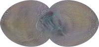
Here's a good map for contemplating tiger stripes in relation to the rest of the moon's surface (15˚ graticles).
A http://rightbasicbuilding.com/2016/01/13/enceladus-gets-another-custom-projection/
|
Posted by: Floyd Jan 13 2016, 12:13 PM
Very nice--Thank you
Posted by: chuckclark Mar 14 2016, 09:46 PM
An LPSC poster is now up, over here:
http://www.hou.usra.edu/meetings/lpsc2016/eposter/2520.pdf
describing how this projection was conceived, and showing three additional aspects (rotated cut lines).
Posted by: stevesliva Mar 15 2016, 03:35 AM
That is very cool! Nat. Geo should just crib the whole thing and stick on one of their maps.
Posted by: eliBonora Mar 15 2016, 03:15 PM
Really nice work, thank you.
Posted by: stevesliva Mar 16 2016, 05:31 AM

That is to say I think it's high quality and I'd like to see it in poster form myself... not endorsing appropriation.

Posted by: chuckclark Mar 17 2016, 12:00 AM
I've posted a high-resolution version of the above map (second row in the poster) over here:
http://rightbasicbuilding.com/2016/03/16/enceladus-b-large-file/
But be sure to read the post. I'm having trouble getting it to load on-screen at full size.
You'll probably have to right-click and select download linked file.
Wish I knew how to fix that problem. Suggestions?
EDIT: Please let me know if you download it successfully.
If unable, send me a message via this forum and we'll figure out a way to FTP the file.
Posted by: Phil Stooke Mar 17 2016, 05:16 AM
Hey Chuckles! I didn't have any problem downloading the image straight into my browser and then saving it.
See you in Houston!
Phil
Posted by: JohnVV Mar 18 2016, 03:17 AM
zero issue seeing it full size
just clicked on the image on that page in Seamonkey
then for a "fit to screen size" i just right click in Seamonkey and select that , or left click the screen when i see the "minus" sign
Posted by: PaulH51 Mar 18 2016, 10:17 AM
Wish I knew how to fix that problem. Suggestions?
One possible issue could be you are using Google Chrome as a browser, Chrome has an issue with displaying some large files, (I have that issue) Try switching to another browser. This works for me....
Posted by: chuckclark Mar 18 2016, 11:01 AM
I'm using Safari, but also happens in Firefox.
I'm beginning to suspect the problem is in my machine, one of the early 27" iMacs with the 5K screen.
The problem shows up when trying to open other very large files in the Safari and Firefox browsers.
But oddly enough (just now try it), the file does open in Chrome!
Thanks for help.
c
Posted by: chuckclark May 11 2016, 09:36 PM
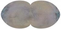
Here's the same projection, but focused on the opposite pole. And with the 0–180 meridian across the middle, left to right.
The trailing hemisphere is the top half and the leading hemisphere is the bottom half.
What I'm wondering is: is there any usefulness to this view? Seems to me that if the incredibly active south pole shows up so distinctly in the first map (above, this thread), and the tiger stripes and the ring around them are due to tidal flexing, we'd see something similar happening at the north pole, where the tidal flexing stresses are presumably no different.
But we don't, right?
(A quick edit: this map is not exactly the same as the first one: the map boundary is slightly altered to reduce maximum shape distortion.)
|
Posted by: JRehling May 12 2016, 02:57 AM
It possible that the tidal flexing is symmetrical at depth, in an underlying rocky mantle, but the rising of that heat upwards is asymmetrical because, having found one outlet to the surface, a cycle of circulation began that rids much/all of the underlying levels of its heat.
Think of a volcano overlying a magma pocket on Earth. It doesn't melt the entire region. It finds expression to the surface in a number of vents possibly just one and the venting there rids the entire local region of heat. In the case of Enceladus, it could be that one vent serves the entire tiny world.
Mars, even, shows signs of very few locales having served as the vents for the entire planet. That's not just one region, and the regions in question aren't that small, but then Mars is a lot bigger than Enceladus.
Powered by Invision Power Board (http://www.invisionboard.com)
© Invision Power Services (http://www.invisionpower.com)