Printable Version of Topic
Click here to view this topic in its original format
Unmanned Spaceflight.com _ Titan _ Huygens News Thread
Posted by: djellison Jan 14 2005, 09:57 AM
Nasa TV will be starting coverage in about 3 mins - but I'm watching multiple TV channels to see if any carry coverage - and will post any news thru the day as it happens
Doug
Posted by: chris Jan 14 2005, 10:00 AM
There goes my productivity today :-)
Posted by: djellison Jan 14 2005, 10:35 AM
Signal detected - it's survived entry 
Doug
Posted by: djellison Jan 14 2005, 10:59 AM
It's on the parachute and a signal is still being recieved 
Doug
Posted by: Sunspot Jan 14 2005, 11:11 AM
I wonder if they will still be able to pick up the signal even after Cassini has passed out of range.
Posted by: TheChemist Jan 14 2005, 11:46 AM
I wonder if they will still be able to pick up the signal even after Cassini has passed out of range.
Batteries will run out soon, unfortunately

Go Huygens ! (where is that Titan emoticon when we need it ?
 )
)
Posted by: YesRushGen Jan 14 2005, 11:50 AM
According to NASA's coverage schedule, we were supposed to have commentary from JPL at 6:30 EST, but that didn't happen.
Still waiting for 7:30am EST back from ESA.
Posted by: TheChemist Jan 14 2005, 12:53 PM
According to the latest commentary, the signal is still being received, and there is evidence that the Doppler experiment is being conducted successfully.
Next update from ESA not before 17.15 CET.
Posted by: Bjorn Jonsson Jan 14 2005, 01:36 PM
It seems Huygens landed between 13:35 and 13:36 CET. A signal is still being received, meaning it survived the landing.
Posted by: BruceMoomaw Jan 14 2005, 01:37 PM
It's been confirmed that Huygens has survived its landing, and is still sending a signal detectable by the Earth radiotelescopes an hour after Doppler data indicated a landing at 4:35 AM Pacific time (19:35 UTC).
Posted by: Bill Harris Jan 14 2005, 01:40 PM
Are there any mirror sites for the ESA and CICLOPS sites? I've tried those "known official sources" and haven't been able to get in. I suspect that most everyone else in the world is trying to, too...
Huygens evidently made it, now if it returned data... whew.
--Bill
Posted by: BruceMoomaw Jan 14 2005, 02:04 PM
As of 6:03 AM (about 90 minutes after landing), Huygens continues to transmit.
Posted by: Bjorn Jonsson Jan 14 2005, 03:11 PM
Huygens was still transmitting as its landing site dropped below Titan's horizon as seen by Cassini.
Posted by: Baltic Jan 14 2005, 03:30 PM
Yeah, 2 hours after landing!
Tom
Posted by: TheChemist Jan 14 2005, 03:59 PM
Great ! Just like the MERs, power is not a problem.
Oh those images, where are they ?
Posted by: Baltic Jan 14 2005, 04:04 PM
Oh those images, where are they ?
On their way to earth I hope!
Tom
Posted by: volcanopele Jan 14 2005, 04:06 PM
Is it still the case that the Earth-based tracking stations would be able to pinpoint Huygens location on the surface fairly accurately? Or did I hear incorrectly?
Posted by: volcanopele Jan 14 2005, 04:20 PM
They're clapping. That's a good sign.
Posted by: Bjorn Jonsson Jan 14 2005, 04:24 PM
Seems some servers are swamped now, I hear only occasional sounds on NASA TV. But I heard a few seconds of clapping...
Posted by: Sunspot Jan 14 2005, 04:29 PM
FRIDAY, JANUARY 14, 2005
1619 GMT (11:19 a.m. EST)
The Huygens data is being received! Applause has erupted in the German control room after the tense and anxious wait. It will take some time to begin examining the information. The first pictures from Huygens could be released later today, if all has gone well.
http://www.spaceflightnow.com/cassini/status.html
Posted by: M_Welander Jan 14 2005, 04:30 PM
At the moment I've found this webcast to be of somewhat higher quality than the main NASA TV webcast:
http://quest.nasa.gov/ltc/ram/nasalive-v.ram
Posted by: Sunspot Jan 14 2005, 04:34 PM
Three thumbs up...thats got to be a good sign lol
Posted by: Baltic Jan 14 2005, 04:45 PM
Damn, I can't see or hear anything from the news conference. 
Tom
Posted by: Sunspot Jan 14 2005, 04:49 PM
I've been watching it here: http://www.unitedspacealliance.com/live/nasatv.htm
Not great quality though
Posted by: M_Welander Jan 14 2005, 04:51 PM
I've found a really good webcast now:
http://science.ksc.nasa.gov/cgi-bin/rrg2.pl?encoder/nasatv.rm
Not a single skip the last ten minutes - though I suppose it'll start breaking up now that I've said it doesn't.
Posted by: Sunspot Jan 14 2005, 04:57 PM
The sound on mine has gone.....whats the latest?
Posted by: Bjorn Jonsson Jan 14 2005, 04:58 PM
I heard a short burst of sound - seems all the experiments did get good science
Posted by: tedstryk Jan 14 2005, 05:01 PM
Something occured to me...will the Huygens data remain just at ESA, or will it make its way to the NASA PDS. I hope it ends up in the PDS system, especially the DISR data....NASA is much better with access.
Posted by: M_Welander Jan 14 2005, 05:11 PM
They believe they have got all the data from all experiments on Channel A (or B - there's some confusion?), however, the redundant Channel B (or A?) appear to be blank.
Posted by: Mongo Jan 14 2005, 05:14 PM
Second try with this post ... the first try seems to have vanished.
According to the current ESA news conference, we are receiving every packet of science and engineering data with no drop-outs. The first 30 minutes of the descent profile was nominal, with the main parachute deploying within 15 seconds of the predicted time. The spin rate of the probe is also nominal.
Bill
Posted by: M_Welander Jan 14 2005, 05:19 PM
The first images could be made available in a little over 2 hours from now.
Posted by: volcanopele Jan 14 2005, 05:24 PM
Channel A, mostly images, maybe blank. This would mean that we lost half the images.
Posted by: Baltic Jan 14 2005, 05:28 PM
Thanks for the links, you saved my day.
Tom
Posted by: volcanopele Jan 14 2005, 05:33 PM
The "fog" light on Disr came on
Posted by: imran Jan 14 2005, 05:40 PM
Channel A, mostly images, maybe blank. This would mean that we lost half the images.
Are you sure about this? Because according to Spaceflightnow the Doppler Wind Experiment may only have been affected.
"One of Huygens' six experiments, the Doppler Wind Experiment, relied in part on chain A of the probe's communications system. It was designed to measure wind speeds by detecting subtle changes in the frequency of radio transmissions as th craft is blown this way or that. If chain A did not work, scientists will lose measurements of that shift between Huygens and Cassini. But Sollazzo said similar measurements from Earth-based radio telescopes will allow scientists to collect similar data to make up the shortfall, assuming the data on chain A is, in fact, lost. "
Posted by: volcanopele Jan 14 2005, 05:48 PM
"One of Huygens' six experiments, the Doppler Wind Experiment, relied in part on chain A of the probe's communications system. It was designed to measure wind speeds by detecting subtle changes in the frequency of radio transmissions as th craft is blown this way or that. If chain A did not work, scientists will lose measurements of that shift between Huygens and Cassini. But Sollazzo said similar measurements from Earth-based radio telescopes will allow scientists to collect similar data to make up the shortfall, assuming the data on chain A is, in fact, lost. "
I just sat in on a status report meeting and they mentioned that Channel A did not downlink and this would cause the loss of half of the DISR images.
Posted by: azstrummer Jan 14 2005, 05:49 PM
Well, half's better than none. Shame the loss is in the images though. How many images are we talking about during the mission duration?
Posted by: Bjorn Jonsson Jan 14 2005, 05:51 PM
That's weird, I understood A and B were redundant with one of the streams transmitted with a short delay to ensure fewer dropouts.
Posted by: pioneer Jan 14 2005, 05:52 PM
Aren't channel A & B redundant channels for Huygens to transmit the same data?
Posted by: volcanopele Jan 14 2005, 05:55 PM
Aren't channel A & B redundant channels for Huygens to transmit the same data?
As far as I know, they are not the same data. Maybe you are confusing this with the fact that Huygens will be retransmitting its data several times?
Posted by: pioneer Jan 14 2005, 06:03 PM
 Perhaps I'm thinking of the Galileo atmospheric probe. Still, I think speculating that half the images are lost is a bit premature at this point.
Posted by: DavidVicari Jan 14 2005, 06:04 PM
No... Huygens will not be re-transmitting its data several times. It sent all its data out in almost real time on two separate redundant channels. One channel was supposed to be delayed by something like 6 seconds so that a temporary comm. loss would not lose data.
Cassini will send its recorded data to earth multiple times and from multiple different memory locations.
Posted by: john_s Jan 14 2005, 06:11 PM
This statement doesn't sound like half the images are lost:
From http://www.spaceflightnow.com/cassini/050114channela.html:
Engineers at the European Space Agency's Space Operations Center in Germany are receiving data from Huygens on chain, or channel, B but not from chain A. Both systems are identical and scientists should receive almost all of the desired data from chain B, Mitchell said.
"The way the probe system works, there are two transmitters on the probe and there are two separate receivers on the orbiter so we have two separate, distinct data links between the probe and the orbiter," he said. "These data links were deigned to be largely redundant, not 100 percent, but nearly so.
Posted by: volcanopele Jan 14 2005, 06:11 PM
No... Huygens will not be re-transmitting its data several times. It sent all its data out in almost real time on two separate redundant channels. One channel was supposed to be delayed by something like 6 seconds so that a temporary comm. loss would not lose data.
Cassini will send its recorded data to earth multiple times and from multiple different memory locations.
Sorry, I meant Cassini will be retransmitting Huygens data several times for redundancy.
Even though Channel A "may" be lost, DISR will still have plenty of nice looking panoramas from the data on Channel B. The Doppler Wind experiment data can be reproduced from the carrier signal on earth and from other Cassini instruments.
Posted by: M_Welander Jan 14 2005, 06:12 PM
From what I've understood, the physical channels A and B (that is, the mechanisms used to create the channels) are redundant. However, the data from the instruments - which are not redundant - is interleaved between the channels in order to use this physical redundance to double the amount of data that can be transmitted during the short time available.
I could be wrong, though. But if I'm not, imagine this scenario, with a sequence of images:
ABABABAB
Now, if we're losing all A's, we'll still be able to get most of the science out of the B's, because we know where the A's where and so by looking at the B's can know what we've lost, either through interpolation or image reconstruction or reprojection or any other means of data recovery.
Posted by: azstrummer Jan 14 2005, 06:14 PM
Ah man, wouldn't you know Sean O'Keefe would use a day like today to do some stumping for his boss and his "grand plan" for space. His speech on NASA TV, even though he touched on Huygens briefly, really rubs me the wrong way. It's like walking into someone's birthday party and announcing you're getting married.
Posted by: Mongo Jan 14 2005, 06:20 PM
One of the questions during the ESA press conference was something like, "what effect will the apparent loss of Channel A have on the scientific results".
The answer given was that there should be very little effect, as the two channels were almost completely redundant. The sound dropped out for me right when the possible effects on the specific experiments were being discussed, but from what I heard, most of the experiments had their data completely duplicated on each of the two channels, while (one or two experiments) split the data between the two channels. One of those 'one or two' experiments would have been the Doppler Wind Experiment, but I don't know which--if any--other experiment may have lost data.
Bill
Posted by: volcanopele Jan 14 2005, 06:30 PM
The answer given was that there should be very little effect, as the two channels were almost completely redundant. The sound dropped out for me right when the possible effects on the specific experiments were being discussed, but from what I heard, most of the experiments had their data completely duplicated on each of the two channels, while (one or two experiments) split the data between the two channels. One of those 'one or two' experiments would have been the Doppler Wind Experiment, but I don't know which--if any--other experiment may have lost data.
Bill
DISR has half their images on Channel A and half on Channel B
Posted by: tedstryk Jan 14 2005, 06:37 PM
The good news is that other than doppler wind data and half the images, everything else was in Channel B. So all data from the other instruments should be recovered.
Posted by: gpurcell Jan 14 2005, 06:40 PM
Ugh. This sounds bad for the DISR images.
How is the data interwoven between the channels? We we lose whole shots, will there be missing patches within shots, or will the image be or lower resolution?
Posted by: trev Jan 14 2005, 06:49 PM
During the entire descent, Huygens will capture and relay to Cassini 1100 images...... so 550 is not bad, i dont know if its the first 550 or last 550 wich may have been lost???....hopefully we still get the full descent... 
http://www.planetary.org/saturn/huygens_mission.html
Posted by: volcanopele Jan 14 2005, 06:50 PM
How is the data interwoven between the channels? We we lose whole shots, will there be missing patches within shots, or will the image be or lower resolution?
Some panoramas are in Channel A, some are in channel B. So we will have whole panoramas, just half of those planned. At least that's my understanding after the status report telecon.
Posted by: volcanopele Jan 14 2005, 06:53 PM
http://www.planetary.org/saturn/huygens_mission.html
see, look on the bright side. The way I understand it, the panoramas are interwoven, as above, ABABABAB. We may have lost more high altitude panoramas than lower altitude panoramas. But it is not an all-or-nothing proposition.
Posted by: tedstryk Jan 14 2005, 07:02 PM
The first pictures of Titan's surface will be released by ESA about 2:45 ET.
BTW, does anyone know the time that the Huygens signal was lost on Earth?
Posted by: tedstryk Jan 14 2005, 07:30 PM
Does anyone know how the DISR images are to be connected...e.g, will loosing half the data mean the loss of all data in one direction consistently throughout descent, or will it be more random.
Ted
Posted by: djellison Jan 14 2005, 07:31 PM
Is the A-channel totally borked - is itt just a bit screwey and thus potential for recovery
Doug
Posted by: volcanopele Jan 14 2005, 07:33 PM
Ted
The loss of one channel will mean they will lose entire panoramas, but other panoramas will reamin intact since they are entirely on Channel B.
Posted by: tedstryk Jan 14 2005, 07:36 PM
Yes, but do you mean 360 panoramas or shorter panoramas that will be assembled into mosaics?
Posted by: djellison Jan 14 2005, 07:42 PM
Consider it like MER. As I see it - you'd have lost the Lion King panorama, and the Endureance Pan Point A Panorama, but the Mission Succes Panorama, the first Endurance Panorama and the Burns Cliff panorama are ok
Doug
Posted by: tedstryk Jan 14 2005, 08:03 PM
Looks like channels!!!!
|
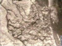
Posted by: Sunspot Jan 14 2005, 08:05 PM
A shoreline? River channels?
http://www.spaceflightnow.com/cassini/050114pic1.html
Posted by: Bjorn Jonsson Jan 14 2005, 08:06 PM
That DISR image I just saw was much sharper than I imagined it would be. The features there were described to look like drainage channels.
Posted by: volcanopele Jan 14 2005, 08:07 PM
HOLY CRAP!!!!!
Posted by: Bjorn Jonsson Jan 14 2005, 08:08 PM
Can't wait to see more images. WOW !!
Posted by: pioneer Jan 14 2005, 08:10 PM
The dark, smooth part on the right looks like a lake of liquid. The squigly lines remind me of a Viking image of Mars showing dried up streams.
Posted by: David Jan 14 2005, 08:16 PM
I want to say that that image literally brought tears to my eyes, being so beautiful and so much of what I'd hoped for. Thanks, Huygens!
Not sure if we're looking at the same image or not, but if we are, then shouldn't those channels (and they can hardly be anything else) be flowing into the "lake" and not away from it, if it actually were a lake? Maybe it's more like a glacier?
Posted by: djellison Jan 14 2005, 08:21 PM
I was the same. It sent shivers down my spine - it was just beyond anything i could possiblt have imagined.
Doug
Posted by: volcanopele Jan 14 2005, 08:25 PM
Not sure if we're looking at the same image or not, but if we are, then shouldn't those channels (and they can hardly be anything else) be flowing into the "lake" and not away from it, if it actually were a lake? Maybe it's more like a glacier?
looks like a delta to me
Posted by: volcanopele Jan 14 2005, 08:27 PM
other possibilities that are coming up are volcanic outflow channels and rain drainage from the last equinox rainy season
Posted by: Roby72 Jan 14 2005, 08:28 PM
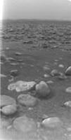
First image from surface !!!!!
http://saturn.jpl.nasa.gov/multimedia/images/image-details.cfm?imageID=1298

Posted by: Pando Jan 14 2005, 08:29 PM
First image from the surface!
http://www.esa.int/SPECIALS/Cassini-Huygens/SEMCXM71Y3E_1.html
Posted by: djellison Jan 14 2005, 08:34 PM
Looks like the bastard love child of Venus and Mars
doug
Posted by: Baltic Jan 14 2005, 08:36 PM
A shoreline? Out there? Okay, it's bitterly cold and not water at all ... but I love the sea and I love lakes, too. I hope *so* this turns out to be a liquid! I'm so thrilled, guys!
Not even Europa has a shoreline! 
Tom
Posted by: djellison Jan 14 2005, 08:38 PM
From John Zarniki (sorry about the spelling)
3 hrs 27 mins and 26 second data in all
1hr 10 minues of data from the surface of titan
Doug
Posted by: SFJCody Jan 14 2005, 08:38 PM
Wow, look how rounded those cobbles are! Maybe the hour+ of surface images could be stacked to improve the resolution.
Posted by: djellison Jan 14 2005, 08:39 PM
Yeah - a thick atmosphere might give a slight bit of motion to the image - perhaps super -res imaging on it
Doug
Posted by: David Jan 14 2005, 08:39 PM
I can't believe that. No delta on earth has outflow channels that get smaller as you go downstream.
Maybe, but I find it hard to see volcanic outflow coming off what looks like multiple watersheds. This looks like a typical earthly drainage pattern.
We know enough about Titan now to know if it has rainy seasons? You're pulling my leg, right?That surface picture -- well, I was wrong about the oozy tar pits.
At least, we didn't land in any. But what's that off on the horizon? Does it look curved because of (1) the optics, (2) because there's some kind of humped formation out there? Oh for a rover!!!
Posted by: Bill Harris Jan 14 2005, 08:43 PM
http://www.spaceflightnow.com/cassini/050114pic1.html
OMG, that is a classic fourth-order dendritic drainage pattern. That is a river. Idea of the scale of this pic?
--Bill
Posted by: David Jan 14 2005, 08:43 PM
Not even Europa has a shoreline!
I would dearly, dearly love for that to be a shoreline and a lake or sea -- just so you know where my biases lie -- but unfortunately I think I see a crater or two in the "lake". If I'm right about the drainage, then the "lake" has to be significantly higher than the surrounding terrain. Could it be, say, the lobe of a (cryo-?)volcanic outflow?
Posted by: tedstryk Jan 14 2005, 08:43 PM
It sure reminds me of the Venera 9 pan. Superficial, but it looks like it. As for the channels...that depends...might this be some sort of a murky delta? That would explain the large channels breaking into a bunch of small ones. The features in the lake could be craters on the lakebed poking through the surface, or, if they are not craters, they may be islands or sand/mud bars,
Posted by: SFJCody Jan 14 2005, 08:47 PM
http://www.lpl.arizona.edu/%7Ekholso/data.htm
Posted by: David Jan 14 2005, 08:50 PM
I think to some extent that has to do with looking out on a kind of bleak overcast landscape on both Venus and Titan. But the details are quite different; on Venus, we had a wholly rocky surface split into sharp-edged slabs; here we're looking at a "sandy" plain (who knows what that stuff is actually) strewn with rounded boulders. It's more reminiscent of Mars, though the rocks are not shaped like the usual volcanic and impact debris we see on the Martian plains.
Posted by: Roby72 Jan 14 2005, 08:53 PM
Cody, what did you mean with triplets ? Image mosaics ? where could it found ?
Posted by: SFJCody Jan 14 2005, 08:54 PM
Click on the link above.
Posted by: azstrummer Jan 14 2005, 08:55 PM
Wow, quite a hazy trip down it appears. Some of those views in the triplets could easily be delta areas on the Earth.
Posted by: David Jan 14 2005, 08:55 PM
Is number 671, top, a view from low altitude looking across the channels toward the horizon? That's the impression I get. If so, I should like to see it with a bit of enhancement -- it should be very interesting.
Just click on the word "Triplets".
Posted by: YesRushGen Jan 14 2005, 08:59 PM
HOLY COW.
I'm completely speechless with the few images we have so far. We need a longer duration mission to Titan. NOW!!!
I'm guessing it will not take the scientists very long to start lobbying for one.
Anyhow, once these images are processed, and Huygens' position is determined accurately, will we be able to Have Cassini reimage the landing area in high resolution so that we can correlate ground truth with Cassini's observations? Doing so would allow better inferences about OTHER areas that Cassini observes.
Posted by: volcanopele Jan 14 2005, 09:04 PM
wow, I just got back from looking at those
Certainly fluids had a hand in this terrain and we landed in material best described as creme broule (I know I misspelled that)
Posted by: David Jan 14 2005, 09:04 PM
I'm completely speechless with the few images we have so far. We need a longer duration mission to Titan. NOW!!!
I shan't be satisfied with anything less than a half-dozen orbiters and two or three rovers.

Seriously, it's going to be tough lobbying for another Titan lander though we clearly need one. At the press conference they were saying that they don't expect to see another one in their lifetimes (and those guys aren't that much older than me!
). This is going to have to be very, very carefully packaged and sold, and unfortunately has to compete with better-funded and flashier programs.
Posted by: SFJCody Jan 14 2005, 09:05 PM
Compare these...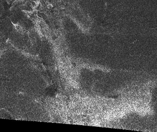

[The one in the centre]
Posted by: tedstryk Jan 14 2005, 09:12 PM
Two questions....are those compressed versions of the images, and is this the complete Huygens set?
Posted by: Mongo Jan 14 2005, 09:19 PM
There are many more photos to come. During the ESA press conference, it was mentioned that they already had received 350 images, partway through transmission from Cassini. The ones released so far are merely the first wave of photos.
Posted by: djellison Jan 14 2005, 09:24 PM
I'm just going to go "wtf" for a while
One part of this looks like a a river catchment area starting at a coastline and working inward...
And another part - just a little further down the coast ( we drifted along this costal feature - we have views from both sides of it )
We have amore classical river channel
I will keep saying WTF till we have a follow on misison
Doug
Posted by: estrand Jan 14 2005, 09:34 PM
Just playing with brightness/contrast on some of the raw images:
http://img9.exs.cx/img9/4122/titancollage0lb.jpg
Eric
Posted by: Fred Jan 14 2005, 09:34 PM
Go here: http://www.lpl.arizona.edu/~kholso/jpeg/ to see lots more triplets. Many of them seem to be duplicates, though.
Posted by: djellison Jan 14 2005, 09:34 PM
Is it feasable that it landed in a small puddle?
That bottom image looks a lot like a shallow puddle - with something sort of sandy in the bottom and pebbles in it - with a torch held next to it
Doug
Posted by: M_Welander Jan 14 2005, 09:35 PM
I find it interesting that we see plenty of smaller impact craters in these images, compared to what appears to be a lack of larger impact craters on a global scale. At the very least, this should help dating the features we see in the images.
Posted by: Fred Jan 14 2005, 09:40 PM
What look like small craters are aparently image artifacts or dust or something. They are in the same place in each image regardless of where the camera is pointing.
Posted by: M_Welander Jan 14 2005, 09:42 PM
You're right, of course. That was stupid of me. I should have noticed that.
Posted by: David Jan 14 2005, 09:50 PM
Right. Well, that detracts from my reasons for supposing that the "lake" was not liquid. I'd still like to see some unambiguous images of the rivers (can I call them that now?) flowing into the "lake".
And if we have that, I'll be happy as a clam to take the quotation marks off.
Posted by: lyford Jan 14 2005, 09:51 PM
doug - mind if I point out some of your great protopanorama work over at BABB? I promise not to slashdot the server!
Or did you lock pics for members only?
Boy - hopping between Mars and Titan and BadAstronomy and Here is hard work!
Thanks
Lyford
PS - It does remind me superficially of the Venera images as well - maybe since the field of view is so small too - for a cold shower just switch quickly between a good http://qt.exploratorium.edu/mars/spirit/navcam/2005-01-14/2N158953499EFFA2GPP1915L0M1.JPG and the http://mer.rlproject.com/wtf3.jpg Hope they improve that much when we send the Titan amphibious rover!
Posted by: Pando Jan 14 2005, 09:52 PM
To me it looks like glacier which is crumbling. The river channels may be cracks where the ice is breaking apart. Just speculating of course.
Posted by: Fred Jan 14 2005, 09:53 PM
I found this strange circular feature in the top image of triplet # 704. Any ideas on what it is?

|
Posted by: djellison Jan 14 2005, 09:53 PM
link from wherever - no probs
just no /.ing - if i get /.'ed - the place will die.
Doug
Posted by: lyford Jan 14 2005, 10:01 PM
Good Lord - that's Port Hueneme, California!


Posted by: Pando Jan 14 2005, 10:04 PM
Esa says the surface closeup shows "ice blocks", hmmm.
This raw image was returned by the ESA Huygens DISR camera after the probe descended through the atmosphere of Titan. It shows the surface of Titan with ice blocks strewn around. The size and distance of the blocks will be determined when the image is properly processed.
http://www.esa.int/esaCP/index.html
Posted by: David Jan 14 2005, 10:08 PM
Well, water is basically a mineral on Titan, right?
Posted by: Baltic Jan 14 2005, 10:21 PM
So ... Huygens was looking in a slightly wrong place?
Tom
Posted by: tedstryk Jan 14 2005, 10:25 PM
I think it will help greatly when we have radar coverage of the site. Hopefully we can use it as sort of a rosetta stone for interpreting radar data from more of Titan.
Posted by: Sunspot Jan 14 2005, 10:29 PM
None of the links work anymore, the pics have been removed?
Posted by: Bjorn Jonsson Jan 14 2005, 10:31 PM
Luckily I managed to download all 367 images with a mass downloader before their removal.
Does anyone know how big the full size images are ? I understand these are just thumbnails.
Posted by: tedstryk Jan 14 2005, 10:35 PM
Darn it, I got a call from the bookstore concerning my textbook order... took so long to deal with that by the time I got off the phone, the images were gone. I have heard that ESA was having fits about their release....Damn them...First Mars Express, and now this.
Posted by: Pando Jan 14 2005, 10:36 PM
From CNN:
For unknown reasons, NASA, which operates Cassini, the satellite orbiting Saturn that relayed Huygens' signal, removed an image of Titan's surface from its Web site. ESA had not released that image. No official information was available about the image from Titan's surface.
ESA's aerial image, a gray low-resolution picture, was snapped 16 km above the surface of the moon. It resolves features, some as small as 40 m across, such as dark winding stream beds.
from: http://www.cnn.com/2005/TECH/space/01/14/huygens.titan/index.html
WTF?!
Posted by: Bjorn Jonsson Jan 14 2005, 10:41 PM
The crackpots are going to love this...
Posted by: Pando Jan 14 2005, 10:44 PM
Well the JPL site still has it!
http://www.nasa.gov/mission_pages/cassini/multimedia/huygens-1.html
http://www.jpl.nasa.gov/
and it's there too on ESA's now?
http://www.esa.int/esaCP/index.html
Posted by: tedstryk Jan 14 2005, 10:45 PM
But the complete set is still gone.
Posted by: djellison Jan 14 2005, 10:49 PM
Well - I got the lot - and there's about - ooo - 150 images from the surface - you know I'm sure you can see the lamp getting dimmer as time progresses
Anyhoo - as someone suggest - I've tried to super-res the surface image from the 150 images taken. sadly - they orig.s were hiddeously jpg'd
but
compared to 
Little difference really.
Doug
Posted by: OWW Jan 14 2005, 10:51 PM
In light of the disappearing images you should read this piece:
http://www.spacedaily.com/news/oped-05g.html
I must say he's right about most of it. I too was screaming at the screen when they showed suits staring at the pictures instead of the pictures themselves. He could have formulated it a bit more politely though.
Posted by: Pando Jan 14 2005, 10:51 PM
Was the complete set ever published at ESA or NASA? If not, I think the reason is that www.lpl.arizona.edu couldn't handle the traffic...
Posted by: tedstryk Jan 14 2005, 10:52 PM
Does anyone know if the compression is a characteristic of the actual downlinked images or if it is just a feature of the public release data? As for the dissapearing data, if that were the case it seems a notice would have been put on the site.
Ted
Posted by: Sunspot Jan 14 2005, 10:53 PM
...ewwwww.......i knew it had to be written by that Jeffrey F. Bell
Posted by: Sunspot Jan 14 2005, 10:58 PM
Are the JPEG artefacts are the result of compressing the images for the web etc? rather than compression for transmission from Huygens?
Posted by: tedstryk Jan 14 2005, 10:59 PM
Maybe this is anger talking, but I think considering we built many components of the probe got it there, relayed the data back, and recieved it on the ground, we should tell the Europeans to shove it and NASA should go ahead and release it without them. Then we should take our sweet time in delivering DSN telemetry from their missions....see how they like it.
Posted by: dot.dk Jan 14 2005, 11:00 PM
Now where is the SOUND of Titan!?
It had a microfone right?
Posted by: Mongo Jan 14 2005, 11:04 PM
I read that piece, and I too must say that I was thinking much the same thing during the ESA press conferences. There was a lot of time concerning various bigwigs congratulating themselves, and very littla actual data released.
Did you notice that the NASA TV descriptions of the two ESA 'images' press conferences did not resemble the actual events all that closely? There were supposed to be about 18 images released during the first conference, with the rest released in the second. Instead, we had ONE image released in the first conference (and there were more available, at least one more image was flashed on the screen for a fraction of a second during the conference, but then hastily removed) and two more in the second 'conference'--although that one was mainly about patting themselves on the back.
Bill
Posted by: M_Welander Jan 14 2005, 11:04 PM
The author is complaining that the TV coverage did not focus on the scientists and the data, but rather on the politicians involved.
It's important to note, though, that the press conferences were - contrary to his claims - to a very large part focused precisely on the scientists and the data. Although one politician did take part in one of the press briefings, the rest of the people there were scientists or technicians.
Furthermore, the author claims that had NASA done a mission like this, there would be no focus on politicans on the Big Day. Strangely enough, I remember NASA TV paying plenty of attention to Al Gore and Arnold Schwartzenegger during the MER landings.
---
That said, I - as a contributor to the organization - still agree that ESA has handled the public aspect of the landing very badly. I too really disliked that they spend ten minutes having people talk about their feelings for the images, and only showed the image for a few seconds. However, I would have been equally displeased if they had let technicians instead of politicians talk about their feelings there. I too would like to see all images released at once, and I would not mind a bit if NASA went ahead and released them without permission (though I know perfectly well they'd never to that, but I can always whish).
Posted by: David Jan 14 2005, 11:07 PM
http://www.spacedaily.com/news/oped-05g.html
I must say he's right about most of it. I too was screaming at the screen when they showed suits staring at the pictures instead of the pictures themselves. He could have formulated it a bit more politely though.
I just got the impression that they were badly set up for publicity and had not really thought through how they were going to deliver information to the public -- or perhaps had not really thought that their job was to deliver information to the public at all, but simply to have an announcement and do an Oscar-night recitation of thanks. I didn't see a lot of politicians around (though I'm a little shaky on who counts as a politician there), but I did feel that too little time was spent on the science.
Posted by: john_s Jan 14 2005, 11:10 PM
Hey, give 'em a break- ESA has never done anything this big before and it's no big deal if they allow themselves a day of self-congratulation. They've been working on this for 15 years and we'll get to see more science results in a day or two, once everyone has calmed down.
Posted by: M_Welander Jan 14 2005, 11:10 PM
One should remember, too, that for ESA this is the very first event of this type with this amount of press interest, where NASA have 30 or more years of experience handling this kind of publicity.
I also think it's misleading to label this behaviour as "European", becase I - as a European - did not recognize it at all. Personally, I would have labeled it "German", but that's just me. I'm sure a German who disliked how the event was handled would have labeled it "French" or something. My point is that claiming that this is how all Europeans do thing, while all Americans do it another way, is misleading at best and dishonest at worst.
Posted by: tedstryk Jan 14 2005, 11:12 PM
Well, except the Giotto Halley encounter. I remember reading that it was chaotically handled as well.
Posted by: OWW Jan 14 2005, 11:14 PM
Yes they were the scientists and technicians and yes they did mention the science, but really; 90 percent of the time it was:
"We are so happy with this partnership"
"ESA did such a wonderful job"
"This shows how Europe can achieve great things"
"Nasa made this possible for us, thank you"
"The team came through! This is an historic event for all partners" ( in 3 languages )
( I should add that these things disgust me too in NASA press briefings. Suits. Shudderrr. )
Posted by: M_Welander Jan 14 2005, 11:17 PM
I must have missed that press briefing - I only saw number two and three.
Let's also keep in mind that during the first three briefings, there were no data available for ESA to comment on.
Posted by: Mongo Jan 14 2005, 11:17 PM
The main thing I remember about Giotto at Halley was a thoroughly unimpressed Margaret Thatcher calling Giotto a 'waste of money'--due, as I recall, to the fact that the Halley images were released to the public in a difficult-to-understand posterised false-color format. When, weeks later, they were released in a more natural 'naked-eye' format, they were far more impressive and easy to understand--but public interest had already waned.
Posted by: tedstryk Jan 14 2005, 11:21 PM
Well, they did say it would be a week on the DISR site before they had proper mosaics. (not to mention color). So that made me think something. When the media show images from Spirit and Opportunity, it is always those first images after landing. Despite the fact that both have returned much more interesting images. So perhaps this also effects their willingness to release raw data early on.
Posted by: M_Welander Jan 14 2005, 11:26 PM
To sum up my position, please criticize ESA for how it has handled certian things, but use real factual arguments rather than racist ones (I'm saying this in relation to the article, not in relation to anything said on this board).
Posted by: Pando Jan 14 2005, 11:32 PM
I was glued to the TV and web when the two rovers landed, and they released the images to the public the moment they were downlinked. In essence, all the world got to see them pretty much at the same time, with Squires, Arnold, and everybody else. That felt really good since we all shared the wonder and awe with the mission scientists. During the MER landings the focus was on the images and the reaction of the scientists. They paid attention to Arnold, yes, but I don't remember him announce anything and congratulate anybody before the first images were shown.
How ESA handled the first image release today was really in a bad taste in my opinion. They are still sitting on a mountain of images, spoon-feeding them to us as *they* feel like it. Same thing goes on with the Mars Express to this day. Seems they want to be 'priviledged' and it is backfiring on them big time.
The DISR guys at arizona.edu put the images up as they got them (in good faith most likely); whether they were removed due to bandwidth or whether ESA came down on them like a hammer, we'll probably never know.
Posted by: lyford Jan 14 2005, 11:36 PM
I have seen several landings in my life, and I really appreciate the NASA image release policy.
Nothing beat that feeling when MER landed and watching live at JPL - basically they had some imagers desktop on the screen- one thumbnail came down, then another, then the whole screen filled with pictures in a flood of data. The applause and screams oversaturated the mic on the cameras there... it was amazing!
I really felt the emotion of the event, as well as the technical triumph.
This is very different. I feel "naughty" for even trying to get leaked images.
Posted by: lyford Jan 14 2005, 11:44 PM
here is a combo of all the sideways shots I got from slashdot - (don't worry they don't know about this board... )
http://homepage.mac.com/lyford/ramm/pano567-nodupes.jpg
I think it was a "splashdown" into a few inches of ???????
Posted by: djellison Jan 14 2005, 11:46 PM
11:38:11 GMT was the Impact timeaccording to the SSP
The SSP wokred fine - all 8 instruments got data
I'm not sure what the hell was going on with the Images - but the practice of a news conference that tells you nothing and includes back slapping and metaphors is certainly not an ESA invetion
That 7th image from the end is just very very VERY like a shoreline, with waves
I thikn we're missing some images from that massive set ( which I got all of ) - as there are two sets of 3 or 4 images that show that coastal feature really well Hopefully the imaging team will focus in on that when they put stuff together for a conference tomorrow
Doug
Posted by: Mongo Jan 14 2005, 11:55 PM
)http://homepage.mac.com/lyford/ramm/pano567-nodupes.jpg
I think it was a "splashdown" into a few inches of ???????
Are those images running in the order that they were taken? If so, it certainly looks to me like Huygens has landed onto a 'reef' some distance offshore.
Looking at the post-landing image, it looks like it is resting in a few cm of liquid, with numerous 'boulders' rising above the liquid.
Once more data are released over the next few days, we should know for certain.
Posted by: M_Welander Jan 14 2005, 11:56 PM
I completely agree with you, that the way ESA handled the publicity was very bad, and the way NASA handles it is very good - at least for the MERs (I still want better Cassini quick-and-dirty raws, even though they seem to have improved recently!).
However, I think the reason for the involvement of politicians during the landing is a lot more benign than some of you seem to think. You have to remember that the Huygens mission is a truly international mission. It's not created by a single country, like the MERs, but by a large number of vastly different countries, many which fought a world war against each other only half a century ago. I don't think it's a stretch to see the involvement of politicians from different countries as part of the political process going on in Europe right now, rather than seing it as a malicious act of mismanagement.
Posted by: djellison Jan 14 2005, 11:59 PM
And lets be honest - we're just impatient - we've waiting 7 years for this - another 48 hours isnt going to kill anyone
Doug
Posted by: lyford Jan 15 2005, 12:00 AM
Very well put.
And Mongo I think those are in order - the probe was spinning at a variable rate so it's facing all over the place...
Posted by: Pando Jan 15 2005, 12:03 AM
Perhaps, but I think they are completely missing it with their PR engine. The best way to bring everybody together in one cause is to release it in one go, without anyone using their priviledges deciding what and when something gets released. That way all people from all nations can feel they are part of the discovery and excitement. I grew up in Europe, I know the cultural and ideological differences all too well.
Posted by: djellison Jan 15 2005, 12:04 AM
I'm looking at the penetrometer data graph -
They think it was a clay, or a wet sand or a snow - with a bit of a crust on the top (Creme Brulle)
Doug
Posted by: djellison Jan 15 2005, 12:08 AM
I think the problem with Europe is that we're happy to work on something together - BUT - we want OUR credit at the end of it - congratulations not as 'europe' but for each member nation.
With MER - you can just go "well done america, now here's some pictures"
Doug
Posted by: lyford Jan 15 2005, 12:14 AM
Doug
Well done, Europe - now here's some pictures :
http://homepage.mac.com/lyford/j/raw/_._.html
Mirror of the raw files. Please let me know if ESA and INTERPOL are on my case...
Posted by: M_Welander Jan 15 2005, 12:17 AM
Really? You must have been traveling a lot, if you know the cultural and ideological differences between, say Estonia and Lithuania, or France and Germany, or Norway and Sweden. I've lived my entire life in Europe, and even I only know a tiny fraction of those differences. Europe is exceptionally heterogeneous. And yes, i deliberately chose countries geographically close to each other. Pick two countries for from each other, and the differences will be even larger.
That's very true. If anything, that could be seen during the management of the Beagle 2 mission.
Posted by: Pando Jan 15 2005, 12:31 AM
lyford -- you da man!
Well, I was a musician and did some traveling back then
, culture was a big part of what I did and where I went, and ideological differences were very apparent when the iron curtain was still up. Oh, and I did grow up in one of the countries you just named above
Posted by: djellison Jan 15 2005, 12:32 AM
It's landed in a bloody STREAM
Watch this carefully
http://www.mars.asu.edu/~gorelick/huygens1.gif
Doug
Posted by: tedstryk Jan 15 2005, 12:35 AM
So is the U.S. But the difference is that the U.S. has been united much longer, politically at least.
Posted by: Pando Jan 15 2005, 12:35 AM
I swear I saw a fish or two in there
Posted by: djellison Jan 15 2005, 12:37 AM
I swear I saw a fish or two in there
well - bits of ice - or bubble or whatever - but twice, something flows thru the scene without doubt.
Doug
Posted by: Pando Jan 15 2005, 12:39 AM
How did you find that gif?
Posted by: Roby72 Jan 15 2005, 12:49 AM
I wonder, if the microphone could hear bubble sounds of this flowing liquid near the probe ?? 
Posted by: OWW Jan 15 2005, 12:52 AM
Are you sure you see a stream? All I see in that gif is that the probe is slightly 'shivering' but the white dots could be artifacts... Can you point the 'stream' out to us?
edit:
Ok, I see some white dots now in some images, but couldn't that be dustparticles blowing in the wind?
Posted by: David Jan 15 2005, 01:08 AM
Watch this carefully
You certainly could be right, though I'm not sure that the picture proves much more than that some areas of the rocky field are oddly flat. I thought when I first examined that image that we might be seeing bits of a dry stream bed; but if the liquid (methane?) is really as pellucid as all that, it would be hard to distinguish in a single image between rocks (ice?) seen through liquid and rocks seen through atmosphere.
The trick would be to see if there are any images that clearly show refraction. I don't know anything about the refractive properties of liquid methane, but I suppose there must be some. It's a pity we have no images of any part of the lander itself resting in or on the "stream" bed.
Posted by: Pando Jan 15 2005, 01:13 AM
What's interesting to me in that gif file is not so much the moving artifacts, but what looks like atmospheric distortion (sort of like what you can see in a hot desert in the distance). Not sure if the effect is real or an artifact of some sort.
Posted by: David Jan 15 2005, 01:15 AM
Here's my imaginative take on it:
Start 2/3 of the way up the image on the left side, where there's an interruption in the rocky field. Follow to the right and down toward the bottom of the image at an angle of about 20 degrees. There is there a broad flat area, which is free of rocks and can be imagined as a liquid pool. Now go back to the middle of the image on the same level, and go down toward the bottom at an angle of 40-50 degrees. Here the 'stream' appears to tumble over a rocky shelf until it hits the large pair of rocks, one horizontal and shaped like a snout, the other rounder and casting a bit of a shadow. The 'stream' flows around and through these rocks and spreads out in a pool below them and to the right. With a bit of imagination, you can see concentric ripples spreading out from the shadow-casting rock; the pool forms a sort of reversed L in a large part of the lower right hand corner.
Can you see it now? Or am I just making all that up?
Posted by: BruceMoomaw Jan 15 2005, 01:24 AM
The word I'm getting now (although I still have to confirm it) seems to be that Jeff Bell did not intend those comments to become public -- they were in an E-mail he sent to me and Simon Mansfield blowing off steam, and Simon jumped the gun and printed it as an article.
Yes, Bell goes overboard sometimes. But -- for whatever reason (which I suspect has more to do with worshipping bureaucracy than with worshipping aristocrats), ESA's PR policies are still consistently lousy and frustrating.
By the way, does anyone have a Web link to the second post-anding science press conference -- the one at which the first images were released (albeit for just a few seconds before the cameras turned back to the Suits)? I slept through the broadcast of that one, and haven't even been able to see it yet.
Posted by: Sunspot Jan 15 2005, 01:27 AM
I should think not

Posted by: Pando Jan 15 2005, 01:34 AM
Here's another mirror for the raws:
http://mars.lyle.org/titan/raw/
Looking at it, does anyone have a tool to put them all running as a movie in sequence (with the descent), *especially* the frames with downward looking camera, which later on shows the light illuminating?
Posted by: volcanopele Jan 15 2005, 01:42 AM
most of those rocks are on the neighborhood of 10-20 cm across, not boulders.
Posted by: David Jan 15 2005, 01:54 AM
Any ideas on what to name those tiny little rivers? I'm thinking Ellison Creek, and Blackwell Rill, and...
Well, I'm sure all the bigger ones are going to be taken by the scientists and engineers who worked on this project, but there's got to be a few hundred thousand left over.
Posted by: BruceMoomaw Jan 15 2005, 02:18 AM
That's OK, David. They can name all those hundreds of thousands of others after all the bureaucrats who keep taking bows during the press conferences...
By the way, a few years Michael Swanwick wrote an SF mini-story on this theme. The guy officially assigned in the late 21st century to work out of a grubby little basement office and invent official names for every single one of the photographed particles of Saturn's rings finds an ancient derelict alien spaceship in there, and -- knowing that no one will ever, ever reexamine his files of photos and accompanying names -- officially names it "Youshouldhavepaidmemore" and then files and forgets it.
Posted by: BruceMoomaw Jan 15 2005, 02:33 AM
Speaking of lousy press coverage, have you seen NASA TV's schedule? After exactly one more report on Huygens -- namely, coverage of a 1-hour ESA press conference tonight -- NASA TV will drop Cassini/Huygens completely and go back to full-time coverage of the [extremely bad word] Space Station instead.
Posted by: volcanopele Jan 15 2005, 02:37 AM
will c-span cover this press conference? Very bad cable at home (blame my landlady)
Posted by: NorbertGiesinger Jan 15 2005, 02:40 AM
Re: they can name all those hundreds of thousands of others after all the bureaucrats who keep taking bows during the press conferences...
good idea ! The Buhlmann river (or creek or arroyo...!?)
But in earnest:
The german minister for Science, Mrs. Buhlmann (yes the lady in the middle of the press conference), is a quite dangerous lady in terms of space policy. She is a severe not to say a furious opponent of manned space flight and strictly against a german participation in the Aurora (manned mars planning) program.
There was a quite sharp question in this context during the press conference without an answer from Buhlmann.
Posted by: Decepticon Jan 15 2005, 06:08 AM
Looking at the Raw data did huygens see ground later on during the decent?
Alot of the pics was smog.
Another question why are the raw pics so small?
Posted by: snake Jan 15 2005, 06:39 AM
>>Decepticon asked: Another question why are the raw pics so small?
The CCD's are small:
HiRes = 160x256 pixels
MedRes = 176x256 pixels
Side Imager = 128 x 256 pixels
source:
http://sci.esa.int/science-e/www/object/index.cfm?fobjectid=31193&fbodylongid=734
Posted by: gpurcell Jan 15 2005, 06:40 AM
It DID land in a stream! Look at the large rock on the left bottom of the animated GIF. You can CLEARLY see water lapping over the top!
Did we get a temperature reading at "sea level" yet?
Posted by: Pando Jan 15 2005, 06:49 AM
Well, if it really is liquid, at -292 degrees Fahrenheit (-180 Celsius) it's anything but water...
Posted by: alan Jan 15 2005, 06:50 AM
I see lots of bright point sources in the "island chains" Could these be active volcanos?
Posted by: gpurcell Jan 15 2005, 06:59 AM
What I am wondering is whether we have a true ground temperature recorded yet, or if the -180 C is from earlier modeling.
Mistyped "water" for "liquid"...Sorry!
Posted by: Pando Jan 15 2005, 07:24 AM
Here is another cool resource for images:
http://anthony.liekens.net/index.php/Main/Huygens
Posted by: slinted Jan 15 2005, 11:01 AM
some new DISR images / mosaics from the ESA press conference :
http://www.esa.int/SPECIALS/Cassini-Huygens/SEMC8Q71Y3E_0.html
Posted by: chris Jan 15 2005, 11:05 AM
I think that one of more of the cameras may be in the liquid. Two obvious bubbles:
One is visible the the bottow left hand corner of the medium res frames (the middle frame). It is there for two frames:
http://mars.lyle.org/titan/raw/triplet.897.jpg
http://mars.lyle.org/titan/raw/triplet.901.jpg
and then vanishes. Compare with this one:
http://mars.lyle.org/titan/raw/triplet.895.jpg
I also think that the high res camera is seeing an out-of focus bubble against its lens for a while. Its harder to see, as the image is overexposed by the light.
For example, at the bottom left of this image:
http://mars.lyle.org/titan/raw/triplet.951.jpg
Here is a shot of the camera lenses in relation to each other, for reference:
http://saturn.jpl.nasa.gov/spacecraft/images/probe-disr-sensor-front.jpg
Posted by: djellison Jan 15 2005, 11:17 AM
Nasa didnt even wait for that Press Conf to finish. They got bored of people talking about the first ever science data from the surface of titan - and cut to some B-Roll of people installing RCC onto a Shuttle.
Nice one
Doug
Posted by: Sunspot Jan 15 2005, 11:36 AM
There's an updated programm about Titan on BBC2 at 2.20pm
Posted by: OWW Jan 15 2005, 11:43 AM
Maybe it will be archived here later:
http://www.esa.int/SPECIALS/Cassini-Huygens/index.html
Posted by: djellison Jan 15 2005, 11:55 AM
I will be watching and will transcribe any cool-ness. They showed the impactor force graph on the program last night - might be something new and cool today
Doug
Posted by: BruceMoomaw Jan 15 2005, 11:57 AM
From Simon Mansdfield: "Have we caused a strike or go-slow -- or is this clown a failed poet? Did you catch that there will be no release of data other than off the video feed? Maybe they'll dump something to Web -- but for now pass the bucket."
While we're on the subject of cretinism in space agencies:
(1) While the ESA scientitic press conference was very well-constructed (no bureaucrats seizing the cameras this time), NASA TV cut it off after 75 minutes -- right while Tomasko was answering a reporter's question -- to resume its Regular Schedule of video clips (specifically, yet another replay of the Deep Impact launch and a speech by Fred Gregory)! Christ. (David Southwood, by the way, actually burst into tears during his talk.)
(2) It turns out that the loss of Channel A on Huygens was not due to any malfunction -- someone at ESA failed to write the software command for Cassini to listen for that Channel! Half the planned 700 descent photos were indeed lost due to this (leading to "holes in the panoramas", according to Tomasko) -- although he says "there was a lot of overlap." (The Doppler wind data can apparently be reconstructed in full from the very good ground-station measurements.) Once again, failure of software rather than hardware is being revealed as one of the major Achilles' Heels in our technological civilization.
As for the science data: it was VERY preliminary, but the following items spring out:
(1) Other than the Channel A goof-up, everything apparently worked perfectly -- one of the 9 sensors on the Surface Science Package stopped working for 3.5 minutes after landing, but then resumed.
(2) The sound recording from the microphone, which was played back, showed virtually no noises other than the wind rushing past the probe during descent -- and the noise from the collection pump for the Aerosol Pyrolyzer switching on and off on time.
(3) Titan seems to be a moist world rather than a wet one. The penetrometer did indeed record what seems to be a thin surface crust with something underneath it the consistency of "clay or wet sand", into which the penetrometer sank 15 cm. There was no mention at all of any liquid seen on the surface -- instead, the dark stuff around those ice chunks on the surface seems to have gaps a little downstream of them. All this suggests, as Tomasko said, that we're looking at surface "soil" which has been softened by liquid trickling along and into it through those drainage channels at a slow pace. (This, in my opinion, may not be all that surprising if Titan's regolith is indeed porous, since the production rate of both liquid ethane and solid organics in the atmosphere is supposed to be very low -- those channels were probably carved over geologically long times by little trickles of liquid, which at some point then tends to soak back into the surface, maybe leaving a residue of dark solid organic stuff behind in the "lakebeds".)
(4) However, there does seem to be a fair amount of atmospheric moisture, in the form of methane/ethane aerosols. The only GCMS data released yet is methane measurements, which took a sudden uptick at about 15-20 km (at 0.5 bars pressure), suggesting a cloud layer -- and the GCMS heated inlet, after landing, also showed signs that liquid methane was being evaporated out of the soil into the instrument. And that intriguing whitish band along the "shoreline" in the sideways DISR photos of it turns out to be invisible when seen from above -- raising, to quote Tomasko, the possibility that the whitish band is actually a strip of methane or ethane ground fog along the "lakebed's" edge.
(5) The first spectrally colorized post-landing photo of the surface was released by Tomasko. Big surprise: both the ground and (to a lesser extent) the sky are orange. However, his spectra of the surface just before landing show it to be mostly water ice, with a surprisingly small amount of hydrocarbons mixed in. Once again, we seem to be looking at a moist world rather than a wet one: one featuring slow, small trickles of precipitated liquid which carve out those channels only very slowly.
I'll listen to my recording of the press conference again to see if I've overlooked something -- there were a few numbers for wind speed and surface temperature which I haven't mentioned here. Meanwhile, there may be be some kind of wrap-up broadcast on NASA TV at 9 AM Pacific time tomorrow morning after all, although I'm trying to confirm this.
Posted by: centsworth_II Jan 15 2005, 11:58 AM
Maybe lost satalite link?
Maybe same problem that lost "chain A" data from Huygens?
Posted by: BruceMoomaw Jan 15 2005, 12:07 PM
Nope -- an official notice was flashed: "Coverage of the press conference is completed."
However, ESA has reprinted some of the press conference data after all -- although none of the graphs: http://sci.esa.int/science-e/www/object/index.cfm?fobjectid=36369 .
Posted by: David Jan 15 2005, 12:14 PM
I'm having a hard time comprehending this. Are we to understand that they never tested the communications between Cassini and Huygens before deploying Huygens? I'm no engineer, but I thought that engineers were in the business of testing stuff. It seems that we've narrowly missed another "Beagle" -- how easily it might have been the case that both channels were lost.
Posted by: djellison Jan 15 2005, 12:15 PM
iirc - Huygens couldnt be tested whilst bolted to the side of Cassini because the lack of dopler would put the two out of tune
But - they did test the Huygens Relay equipment by transmitting a simulated huygens signal which cassini sucefully recorded and relayed back.
Doug
Posted by: BruceMoomaw Jan 15 2005, 12:29 PM
To repeat: apparently the problem is that someone at ESA failed to include, in the set of Cassini software commands for the Titan encounter itself, the command that would actually allow Cassini to receive Channel A telemetry. (Channel A had worked perfectly on previous in-flight tests.) David Southwood stated twice that the failure was ESA's -- not NASA's -- and promised an investigation.
Posted by: David Jan 15 2005, 12:33 PM
Thanks, Bruce. I just assumed that they would have used the same set of commands that they would have used during tests, and that if not, then this was the first time they'd used these commands because they hadn't even done tests. Thanks for setting me straight.
Posted by: Sunspot Jan 15 2005, 12:46 PM
Sounds from the Huygens "Microphone"
http://planetary.org/sounds/huygens_sounds.html
http://esamultimedia.esa.int/multimedia/sounds/cassini-huygens/Sound_of_Titan-After_Impact.mp3
Posted by: David Jan 15 2005, 12:55 PM
It seems that the surface of Titan is a very, very quiet place. I didn't even hear crickets chirping. 
Posted by: tedstryk Jan 15 2005, 12:57 PM
Am I correct in assuming that the jpeg artifacts are an actual characteristic of Huygens transmission? Also, after my comments about ESA yesterday, I still stand by the fact they did a terrible PR job. Just like NASA, with O'Keefe using it to plug the Shuttle/Station, and then cutting away from a press conference to show the Deep Impact launch again.
Posted by: Roby72 Jan 15 2005, 01:42 PM
I miss probe images of heights under 1km..anyone know about this images with resolutions of about 20cm´s ? Did show it nothing, because boulders are smaller ?
Posted by: Roby72 Jan 15 2005, 01:43 PM
or are they lost in the death channel ?
Posted by: Roby72 Jan 15 2005, 02:04 PM
Currently Tomasko refer only to images taken in 8km and 16m, the images taken higher in the atmosphere do not show much, because of the fog layer in about 20km. This layer was mentioned in the news conference a few hours ago.
I´ve added a table of the planned image cycles which I found in a PDF document of the Descent Trajectory Working Group (DTWG). I suspect the mosaics in 13.7 and 11km heigth are lost due the channel problem, also the deeper cycles below 8km. Other explanations ?
Posted by: BruceMoomaw Jan 15 2005, 02:34 PM
Another theory about the drainage channels: since the heated inlet on Huygens' GCMS managed to evaporate at least traces of what seems to be liquid methane out of the local water-ice "soil" in one of dark "lakebed" drainage areas, is it possible that there are occasional methane rainstorms that reach the surface on Titan and carve those channels? In that case, the channels would be arroyos, usually but not always dry. We might be looking at an eerie analog of one of Earth's deserts. (And this may be more plausible that assuming that just the extremely slow, faint downfall of radiation-produced liquid ethane was enough to carve them -- that rain by itself would be so slow that the liquid might well just soak directly down into the regolith as soon as it struck the surface.)
Posted by: djellison Jan 15 2005, 02:50 PM
From the BBC program - about 95% repeat from last nights program, 4% the images we've already seen,
The probe is resting at about 12 degrees from Horez - perhaps resting on one of the little pebbles.
Temperature profile - similar to the earth - there's a minimum temp at altitude of -200 deg c - and warm up by about 20 degrees on the ground
Sonar - evidence of echos at height - possibly clouds laden with liquid -
And that's it
Doug
Posted by: DEChengst Jan 15 2005, 02:55 PM
That Open University guy was wondering what on Earth could cause that. I think it's more interesting to know what on Titan caused it
Posted by: Decepticon Jan 15 2005, 03:04 PM
I fing it funny they call the images Hi-Res images when they look like Tumbs to me.
Posted by: Decepticon Jan 15 2005, 03:07 PM
Has anyone tried to stack the images? (Ground Images)
I have no clue how its done.
Maybe that will clean up the images.
Posted by: BruceMoomaw Jan 15 2005, 03:16 PM
ESA confirms it screwed up Cassini software: http://www.space.com/missionlaunches/huygens_update_050115.html . Thank God they didn't screw up the instructions for BOTH channels. Still, it's no worse than Lockheed Martin designing all four of the parachute switches for Genesis upside down. Once again, it's becoming clear that nowadays design error -- including software error -- now causes more malfunctions than random manufacturing mistakes do, and it's high time that a lot of businesses besides spcecraft builders realized this.
I will try to find out just what DISR images actually were lost as a result of this screwup, but I make no promise that I can do so in the immediate future.
Posted by: David Jan 15 2005, 03:20 PM
If Titan has other weathering processes, like wind erosion (and I'm sure it does), then I'd expect the rainstorms to be more than just occasional to produce the intricate drainage seen in the pictures. Otherwise I'd expect the erosion to have effaced the smaller channels. I am frankly quite suspicious of any explanation that does not involve the regular flow of liquids along these channels. They should probably drag in some professional hydrologists -- I don't imagine that the scientists strongly expected that that competence would be required eight hundred million miles away.
If we had a more complete map of Titan, we could tell whether we only had these small drainage basins, or if they here and there unite into larger river-systems. Also, do they flow only into the dark areas, or are there other places where we have drainage?
Posted by: dot.dk Jan 15 2005, 03:43 PM
The SOUND of Titan!
http://esamultimedia.esa.int/images/huygens_alien_winds_descent.mp3
How cool is that!?
Posted by: Decepticon Jan 15 2005, 03:54 PM
Lots of pics here.. http://danajohnson.quriophotos.com/peerServer/guest/explode.jsp?id=772
Posted by: alan Jan 15 2005, 04:09 PM
Did Huygen ride the parachute all the way to the surface or did it cut it lose and freefall the last part to keep the parachute from draging or covering it.
Posted by: djellison Jan 15 2005, 04:11 PM
I have no clue how its done.
Maybe that will clean up the images.
Little to no benefit because the camera doesnt move. To do super res imaging on mars - they bump the camera around a tiny bit
Oh - and it parachuted all the way to the surface
Doug
Posted by: SFJCody Jan 15 2005, 04:25 PM
http://www.spacescience.ca/titan/Titan_huygens_landing_site_mosaic_big.jpg
Posted by: tedstryk Jan 15 2005, 04:26 PM
I was hoping atmospheric distortion might create a similar effect. We are lucky the parachute didn't cover the camera's field of view!
Posted by: azstrummer Jan 15 2005, 04:37 PM
Alright, I've heard the audio files from the ride down and the meager sounds of wind while on the surface. Where's the file we're all interested in the most - the sound of the probe hitting the surface?
Posted by: Sunspot Jan 15 2005, 04:39 PM
Im still wondering if all the severe compression artefacts are present because theye been saved for posting online or the images were transmitted in that way? Can anyone elaborate?
Posted by: OWW Jan 15 2005, 04:48 PM
In the BBC program one of the scientists showed that 360 degree mosaic on a printed piece of paper and it had the same JPEG 'blocks' as the online version. So I think it's just a result of low contrast on Titan.
Posted by: David Jan 15 2005, 05:09 PM
Judging from the mosaic, the river systems we've seen are all on a peninsula -- which could explain why we're seeing such small drainage basins. It would be wonderful to see images of the middle of one of the "continents". Oh well -- I suppose we're going to have to make do with muddy Cassini images for another decade -- or more.
It is much better than nothing.
Posted by: Decepticon Jan 15 2005, 05:26 PM
It is much better than nothing.
Don't rule out cassinni images yet.
The more images we get of titan the clearer they will be.
And don't forget the radar.
Posted by: SFJCody Jan 15 2005, 05:36 PM
So the light areas are icy uplands riddled with dendritic drainage channels. What process is creating the uplands?
Other things:
Not a single impact crater.
Where are the aeolian features? It looks fluvial to me.
Posted by: tedstryk Jan 15 2005, 06:17 PM
Once we have built up a good amount of Radar, Vims, and ISS data, I think our picture will improve. BTW, here is my attempt at a super resolution view of the surface view. It is a combination of an image I made from 131 frames and an image I generated from selecting ten good frames from throughout the surface mission.
|
Posted by: tedstryk Jan 15 2005, 06:37 PM
Here is a colorized version.

|
Posted by: Baltic Jan 15 2005, 06:44 PM
I have a problem with one of the green lines (A). I added some yellow ones to make clear why this is so. What do you think?
Tom

|
Posted by: stonehat Jan 15 2005, 07:32 PM
While amazed and delighted we got there at all, I am somewhat disappointed because from the actual imaging instrument's site, I was led to expect this sort of image ( warning it 2500x2500 ) :
http://www.lpl.arizona.edu/~kholso/images/team_images/h3_500_big_gnom.jpg
Did something go wrong ( channel A ? ) or was this sort of resolution never really expected ? ( In which case, why the picture on the arizona site ? ).
Stonehat
Posted by: volcanopele Jan 15 2005, 07:36 PM
I have a problem with one of the green lines (A). I added some yellow ones to make clear why this is so. What do you think?
Tom
I think both the green a line and your yellow line are not correct. I will post my version when I get in to work. I am going to try to put together some panoramas before a public event here tonight.
Posted by: Baltic Jan 15 2005, 08:02 PM
Stonehat
I think I read somewhere that they need at least a week to put something like that togather.
Tom
Posted by: alan Jan 15 2005, 08:24 PM
I have a problem with one of the green lines (A). I added some yellow ones to make clear why this is so. What do you think?
Tom
The features don't line up right because the colorized mosiac at the bottom is put together wrong. I see one obvious feature that is duplicated. The right third of it probably does not fit on that side.
Posted by: Sunspot Jan 15 2005, 08:34 PM
http://www.lpl.arizona.edu/~kholso/images/team_images/h3_500_big_gnom.jpg
Did something go wrong ( channel A ? ) or was this sort of resolution never really expected ? ( In which case, why the picture on the arizona site ? ).
Stonehat
The first panoramic image released today was an "absolute raw" image according to the scientist that produced it at the press conference.. As others have said, I suspect when they've had enough time to properly process the images a much better version will be released.
Posted by: tedstryk Jan 15 2005, 08:36 PM
Considering the confusing details, they probably need to use spacecraft attitude data to make sure they aren't lined up wrong.
Posted by: Decepticon Jan 15 2005, 08:36 PM
http://www.lpl.arizona.edu/~kholso/images/team_images/h3_500_big_gnom.jpg
Did something go wrong ( channel A ? ) or was this sort of resolution never really expected ? ( In which case, why the picture on the arizona site ? ).
Stonehat
The first panoramic image released today was an "absolute raw" image according to the scientist that produced it at the press conference.. As others have said, I suspect when they've had enough time to properly process the images a much better version will be released.
But will the images be bigger?
Posted by: tedstryk Jan 15 2005, 08:40 PM
The images are full size. Remember, these are framelets that are to be assembled into images. The problem is that we are missing half of them, so I hope they can put them together.
Posted by: David Jan 15 2005, 08:57 PM
Assuming an ocean on Titan -- either now or in the past -- would it be subject to tides? What would the intervals between those tides be? Would they be larger or smaller than those on Earth?
I'm wondering whether these "shoreline" areas experience periodic inundations and desiccations, and if so, what the intervals between those inundations might be -- and whether this could be something that Cassini could detect.
Posted by: OWW Jan 15 2005, 10:03 PM
The bottom camera shows an object in triplets 897 and 901 that is absent in all other surface triplets. It's in the bottom left corner. Other evidence for 'dust in the wind' or 'particles in a stream'?
Now you see it: http://homepage.mac.com/lyford/j/raw/triplet.901.jpg
Now you don't: http://homepage.mac.com/lyford/j/raw/triplet.903.jpg
Also, some of the bottom camera pictures show the lamp shining brighter than in others. Battery fluctuations?
Posted by: NorbertGiesinger Jan 15 2005, 10:20 PM
As I posted on other sites since months, tides must be there with a fundamental period of the order of revolution /2 = 8 days.
The tidal amplitude in a hypothetical free global ocean would be of the order of about 15 meters !
In smaller basins it will be substantially lower, but I guess 1-3 m will be possible in basins of some 100 km diameter.
There is another very important action in smaller basins seldom mentioned: the "seiches". These are bathtub waves. On Lake Geneva, with a lenght of about 60 km, the seiches are of the order of 1m in amplitude and some hours full period. Seiches are exited not by tidal interaction, but by the wind.
On lake Constance, the mean amplitude is only about 25 cm, but in rare circumstances, there have been aperiodic seiches in the bay of Constance with an amplitude of 1,5 m and a period in the range of an hout
A strong steady wind is important. You have it on Titan - the wind speed must not be high since the surfave atmospheric density is about 10 times the earth atmosphere density so I guess some m/sex will be sufficient.
I think there are some calculations by exoerts about this matter for Titan - however I never read about in newsgroups etc.
Some people said there are no tides since Titans rotation period is equal its revolution period. Thats would be true for e=0, but there is a very substantial eccentricity of its orbit of 0.03 which will result in strong tides.(I published about it in 1982 in the german "Sterne und Weltraum")
Posted by: Mongo Jan 15 2005, 10:32 PM
There is a very interesting collection of images at http://anthony.liekens.net/index.php/Main/Huygens.
Images that particularly caught my attention included:
This http://anthony.liekens.net/titan/titan_panorama_polar.jpg, and this http://anthony.liekens.net/titan/titan_panorama.jpg, by Christian Waldvogel, similar to the one released by ESA, but of higher quality.
Another http://anthony.liekens.net/titan/mosaic2.jpg of the 'shoreline'. by Kevin Dawson and enhanced by Anthony Leikens.
Kevin Dawson also compiled http://anthony.liekens.net/titan/points_of_reference_to_mosaics.jpg, comparing reference points between two mosaics at different heights.
This site was brought to my attention by Neil Halelamien.
Bill
Posted by: Bill Harris Jan 15 2005, 11:29 PM
>As I posted on other sites since months, tides must be there...
And nature is full of systems that get started and develop a resonance, no, a cyclic behavior. Good discussion of the possiblity of Titanian tides.
I wonder, would it be possible to explore Titan with a series of lighter-than-air blimps? What is the pressure/density/temperature of the atmosphere below the cloud deck, say at 5-15 km?
I imagine that a SAR/SLAR radar system similar to what was used with Venus would be wonderful to do the prelim recon of Titan.
Wonderful images, data and discussion!
--Bill
Posted by: tedstryk Jan 15 2005, 11:42 PM
Well, we already have that on Cassini. Now, if in an extended mission it can get into orbit and provide global coverage with it, we might get some great imagery!
Posted by: dot.dk Jan 15 2005, 11:55 PM
Wouldn't it require a hell lot of braking speed=fuel for Cassini to get into Titan orbit?
Maybe an extreme aero capture combined with a big main engine burn could do it
Posted by: Mongo Jan 16 2005, 12:07 AM
A few years ago, I read a Cassini Mission report on several options for a Cassini Extended Mission. One of the options was in fact aerobraking into a Titan polar orbit. I don't know which, if any, option was eventually chosen. The summary of the Titan Orbit Extended Mission option was that it held the potential for greatest scientific return, but was also the riskiest to perform.
Bill
Posted by: dot.dk Jan 16 2005, 12:18 AM
Here is a list of options for Cassini in extended mission
http://digilander.libero.it/lucktam/EXT.html
Even escape gravity of Saturn is apparently an option
So let's go for Uranus and Neptune
Posted by: chris Jan 16 2005, 12:43 AM
Good plan!
Now, if we just can get Huygens back, we can investigate Triton as well
Posted by: Sunspot Jan 16 2005, 12:46 AM
Hopefully it will be possible for the science teams to add some colour to the panoramic images taken during decent.... just as they have with the image taken on the surface.
Posted by: dot.dk Jan 16 2005, 12:48 AM
No problem. We slingshot Cassini back to Earth. Installs a new Huygens probe build to land on Triton. Then we fuel Cassini and off we go again
Sounds like a great plan
Or maybe to far fetched after all...
Posted by: BruceMoomaw Jan 16 2005, 02:19 AM
No plan has yet been devised for any ultimate mission for Cassini, nor have even any plans for its first extended mission been accepted -- it all depends, after all, on what interesting things it finds at its various targets, and it's very easy to visualize the scientists wanting to take a better look than originally planned at, say, the rings or Enceladus.
However, Robert Mitchell did tell me a few years ago that, as things now stand, better surface coverage of Titan is regarded as the single most important goal in any extended mission.
Posted by: tedstryk Jan 16 2005, 02:20 AM
Except that with Triton's thin atmosphere, the descent would last a minute or two max, followed by a high speed impact that would probably leave a crater and all traces of the Huygens. Retrorockets would be needed on Triton.
Posted by: BruceMoomaw Jan 16 2005, 02:22 AM
The revelation last night that the heated inlet of the GCMS after landing evaporated some liquid methane from the "soil" of Titan in the dark drainage area where it landed suggests to me that Titan's surface may be an eerie analog of Earth's deserts, with water ice serving as the sand and rock, and the drainage channels being its arroyos -- channels carved by occasional light rains of liquid methane coming down from Titan's small clumps of clouds, with the liquid then evaporating or soaking into the porous water-ice regolith (pulverized by the rain of meteor impacts over the eons) to form drying "mud".
This may actually be a lot more likely than my earlier theory that the channels might have been carved even more slowly by the geologically slow drizzle of liquid ethane from the skies. Quite apart from that liquid methane in the soil, the ethane downflux is so slow that it's hard to visualize it totally erasing even the most recent small impact craters on Titan's surface ( which are indeed totally missing in all the pictures we have); and since it's so slow, I would also tend to think that it would all soak vertically down into the soil instead of running horizontally across the surface -- although I suppose it might encounter a solid underlying stratum a short distance down across which it would then flow sideways underground, thus carving out the channels by underground sapping rather than surface flow. (That latter theory, however, could also fit the idea that the arroyos were carved by liquid methane rain.) The black goo would be the residue of solid organics very dilutely mixed with the rain and accumulated on the floors of the arroyos and drainage playas over the eons, having been washed off the higher ground.
By the way, we have here an indication that the heated GCMS outlet -- by itself -- has told us a lot more about Titan than all of Zarnecki's SSP sensors combined. Indeed, except for the acelerometers -- and maybe the thermal conductivity and speed-of-sound sensors -- I imagine all of them were utterly useless in that solid (or thick semi-solid) material; even the graph of the echo sounder's data shown last night showed a clear echo from the surface during the last 100 meters of descent, but no sign of any subsurface structure visible in each echo. (But then, I'm surprised that all the SSP sensors and the heated GCMS inlet even functioned after landing -- those two experiment packages protrude some distance below the lander's main deck, and Ralph Lorenz had predicted they'd both be wrecked if the lander came down on any significantly hard surface. Incidentally, the ESA wasn't the only group hesitant to put the SSP on Huygens -- in its 1992 instrument recommendations for the Cassini mission, COMPLEX suggested that impact accelerometers should be the only specifically surface-related sensors on it.)
Posted by: BruceMoomaw Jan 16 2005, 04:35 AM
I've put out an E-mail to Tomasko, Lorenz, Peter Smith and Katie Holso asking them whether Huygens did get any images between 8 km altitude and the surface, or between 16 and 8 km. No replies yet.
An examination of the description of the DISR ( http://www.rssd.esa.int/SB/HUYGENS/docs/SP1177/tomask_1.pdf ) would suggest that they could have alternated very easily between Channels A and B for the images below 8 km. After a final 36-image panorama at 5 km, Huygens was supposed to NOT completely fill its DISR buffer again before downloading its accumulated images to the probe's radio system, in order to avoid the possibility that it might crash and fail before the final images could be sent back. Insted, it was supposed to take -- and then immediately send back -- isolated image triplets between 3 km and 500 meters, and then 2 to 5 isolated individual frames from the down-looking HRI between 2 km and 500 meters -- and it could easily have alternated the transmission of these individual triplets or singles between the two channels, since by then it was taking 2 minutes or more to fall one kilometer. Whether they actually followed this seemingly common-sense course of action, or devoted all the final pre-impact images to Channel A for some reason I don't yet understand, is the question. (I do know, thanks to last night's press conference, that they duplicated all the DISR spectral measurements -- which had a smaller data volume -- on both Channels, right to the end.)
Posted by: David Jan 16 2005, 04:51 AM
Why do we need to invoke rainfall at all, except as a source to replenish the methane with which, it sounds like, the ground is soaked? [Not exactly parallel to a desert.] Most rivers on earth are fed either by the melting of a permanent snow and ice cover, or by springs from which excess groundwater emerges. Why couldn't the channels we see be fed by an underground "methanifer"?
Posted by: BruceMoomaw Jan 16 2005, 05:52 AM
Well, Huygens touched down in one of the dark areas -- presumably one of the places onto which the channels drain (the "playas", as I'm starting to think of them). And to assume that the channels are initially supplied from an underground methane aquifer, one would, I think, have to assume that this aquifer, located on higher ground, is somehow itself at higher altitude than the drainage basins without filling them directly.
There has been some difficulty explaining the valley networks on Mars as due to underground sapping for this reason -- in that case, the assumption is that either local geothermal heat melted some underground ice in some of Mars' higher-altitude regions, or that local precipitation (maybe snow which later melted) dumped liquid water onto some areas in Mars' high-altitude terrain and some of it trickled directly down through the ground to supply a high-altitude aquifer there. But these theories can't apply on Titan -- there seem to be drainage channels leading away from virtually EVERY patch of higher ground there.
Posted by: BruceMoomaw Jan 16 2005, 06:03 AM
News which pleases me no end: Bashar Rizk, the head of the DISR imaging team, has just gotten back to me via E-mail with the following message:
Moomaw: "Given the loss of half the DISR images due to the foul-up with Channel A, could you tell me whether Huygens returned any images from between 8 km altitude and the surface -- and also whether it returned any from the two panoramas planned for 14 and 11 km altitude? Thanks very much for your time and trouble -- and congratulations."
Rizk: "Yes, we got some 56 images between 8 km and the surface, by our estimates, but this could be off by 5 or 10 in either direction, because our altitude scale is still uncertain. We returned images from all altitudes, just half as many as expected due to the loss of Chain A. The images were lost from the transmission randomly, because our onboard software, not knowing about the lack of power on the RUSO on the orbiter, kept adding to chain A, as well as chain B. If the failure had occurred on the probe, we could have directed every image to chain B and had complete triplets at the cost of fewer panoramas, a trade we would gladly have made, but c'est la vie. We feel grateful and lucky to have even gotten data, considering that DWE got nothing."
Obvious next questions (which I've asked him):
(1) When will those lower-altitude images be released?
(2) If Huygens sent individual frames in each panorama to both channels, how did they get the complete 360-degree panorama at 8 km altitude which was released at last night's press conference?
Still, while he seems unhappy that they got discontinuous panoramas at a wider variety of altitudes rather than complete panoramas at a smaller number of altitudes, I'm absolutely delighted that they apparently did get some really low -altitude aerial views of Titan's landscape as well. I will, of course, let you know immediately when I hear more news on all this. (Also, note his flat statement that the failure came because the RUSO receiver on Cassini had not been turned on.)
Posted by: alan Jan 16 2005, 06:16 AM
Bruce I skimmed through the pdf you linked to. According to it the surface science lamp comes on at 400 meters and the last image is taken at 200 meters The light appears to be on in these images:
http://homepage.mac.com/lyford/j/raw/triplet.710.jpg
http://homepage.mac.com/lyford/j/raw/triplet.716.jpg
So it looks like they got at least two images back from below 400 meters. Not much to see in them, I guess the rocks were to small to be resolved at that altitude.
Posted by: sjdprods Jan 16 2005, 06:16 AM
Hi all --
Been lurking here for several months, mostly on the MER boards, but have enjoyed the Titan discussion as well. Thanks.
On the topic of the "official" first image release (the "drainage channel" image at about ~11:50PST (~19:50UTC) on Friday), and the subsequent applause by the gathered officials: I could have sworn I saw the image on the screens of the Huygens mission control room before the official program began. Sure enough. On reviewing the tape, during the live feed of the control room ~3 minutes before official program begins, the image of the "drainage channel" comes up on a couple of the big screens (you even see a couple of people remark on it, though they don't look that excited about it). They then cut to the little ESA / Huygens intro, then there's the whole "event" with Martin Ransom, the "reveal" (without actually seeing the image), extended applause, and that commentary by various officials.
Perhaps I was completely foolish to think that was the first time those gathered individuals had seen the image, but I felt rather misled, particularly when contrasting it with the spontaneity of not only the MER image releases on those first nights, but even the commentary by Carolyn Porco of the Saturn ring images as they streamed down shortly after SOI. I have my problems with NASA TV coverage, but the kind of "staged" release that I saw from ESA really drives me insane, and makes me thank my lucky stars for NASA and JPL.
Anyway, back to the real stuff, which due to the wonders of the web we have in hand (the lack of "official releases" notwithstanding).
Thanks again for all your great insights and imaging work.
Posted by: BruceMoomaw Jan 16 2005, 06:19 AM
In this connection, a question for Lyford: you claim that your (very useful) collection of images at http://homepage.mac.com/lyford/j/raw/_._.html is a mirror of the raw files that were originally posted at http://www.lpl.arizona.edu/%7Ekholso/data.htm before the ESA demanded that they be yanked. But your site lists fully 367 triplets, whereas (judging from the number of links) there were only 16 triplets on that DISR page. What gives?
Posted by: Pando Jan 16 2005, 06:48 AM
Bruce, they were all posted in http://www.lpl.arizona.edu/%7Ekholso/jpeg/ before they were yanked, the web server gave the whole list as a directory listing. The website had (and still has) links to only 16 of them.
Posted by: BruceMoomaw Jan 16 2005, 07:14 AM
In that case, there's still a puzzle -- those 367 triplets included, by definition, 1101 individual frames, and only about 122 of the triplets seem to have been taken after landing, leaving us with about 735 frames on Lyford's site that were apparently taken before landing. But only about 350 are supposed to have been returned before landing (and the original plan, according to http://huygens.oeaw.ac.at/Papers/DTWGRev3.pdf and http://www.rssd.esa.int/SB/HUYGENS/docs/SP1177/tomask_1.pdf , was indeed to return only about 600 before landing and another 250 during the first 10 minutes after landing). So one is virtually forced to the conclusion that there must be one hell of a lot of duplicates on Lyford's site, and thus in the original DISR raw images file. Also, are the 2 to 4 non-triplet individual HRI shots that were supposed to be taken below 500 meters in there somewhere, or were they lost on Channel A?
Posted by: David Jan 16 2005, 07:52 AM
I'm not sure why that's a problem. Mountain springs are not exactly rare. If springs are feeding the channels in the pictures, they are obviously a lot closer to the elevation of the dark area. I know of a spring that bubbles up within a hundred feet of a lake and is probably only one or two feet higher in elevation.
As for the (apparent?) "dry" state of the landing site, first of all I'm not really clear on how "dry" it is; from the description, it sounds as if the ground is actually mud or liquidy sand. How do we know that the outflows aren't just soaking into the dark area and saturating the ground but only pooling at altitudes lower than where the lander is sitting?
The "shoreline" formations suggest to me that the area has been inundated, or gets inundated regularly, with the same stuff that leaves the dark deposits in the channels. Maybe this is just a relic of a past climate. Or perhaps in eight days a tide will come in and wash Huygens out to sea.
But if we're looking at a dry ex-lake bed, why don't we see channels cut through the dark zone as well? If you had periodic inundations and an unstable surface, of course any channelling through the dark zone wouldn't last. But if you have a dry dark surface and periodic if rare rainstorms cutting arroyos through the light zone, I see no reason that they shouldn't cut through the dark zone as well.
Posted by: BruceMoomaw Jan 16 2005, 09:30 AM
Nice montage of images at http://www.spaceflightnow.com/cassini/images/050115montage.jpg -- including one which, it's absolutely clear from the context, was taken at considerably lower than 8 km altitude.
Posted by: Bill Harris Jan 16 2005, 09:40 AM
It is a mystery about the early release of images at lpl.arizona.edu. I downloaded those images at work at about 3:15 PM CST and as a "CYA" copied them to floppy to take home. I have 11 images, and skipped some of the "duplicate" surface images.
Have the contacts at lpl.arizona been contacted?
My impression of the landing site is being very humid and "drizzly", much like the Pacific Northwest of America. I'm not sure of the hydrologic cycle of methane but I presume that it evaporates, condenses and precipitates like dihydrogen oxide.
--Bill
Posted by: NorbertGiesinger Jan 16 2005, 11:02 AM
http://homepage.mac.com/lyford/j/raw/triplet.710.jpg
http://homepage.mac.com/lyford/j/raw/triplet.716.jpg
So it looks like they got at least two images back from below 400 meters. Not much to see in them, I guess the rocks were to small to be resolved at that altitude.
Concerning remarks "not much to see" or even "blank" for a number of bottom pictures of the triplets - some quick contrast processing shows that there is some information content in it. Lets see what the "masters of the DISR" will do with them...
Posted by: Decepticon Jan 16 2005, 11:34 AM
I have yet to see any atmosphere data?
I'm curious as to what Huygens detected element wise.
Posted by: Sunspot Jan 16 2005, 11:38 AM
This is an enhanced version of triplet 700, it does seem to show some linear surface features in an area that, at least from the RAW image, look featureless..
|
|
Posted by: tedstryk Jan 16 2005, 12:51 PM
We also have to remember that in addition to being transmitted in a lossy way, the "raw" images have also been jpeged, so perhaps there is more low-contrast detail in the originals the DISR team is working with.
Posted by: remcook Jan 16 2005, 01:07 PM
never mind - link was already posted
Posted by: remcook Jan 16 2005, 01:41 PM
my opinion about the PR stuff (i wasn't online when all the fun started )
ESA should have done better in that respect, but as long as the science is good, you don't hear me complaining much.
I could be wrong, but I thing Europeans aren't nearly as web-based as the americans. I don't think a lot of europeans were watching the webcast. What impressions do you people get about this?
Anyway, I hope ESA will learn from all of this (incl. MEX) and will improve PR. Because in the end, it's the taxpayers who are paying.
Posted by: Bill Harris Jan 16 2005, 02:18 PM
What was the stage of the tide at the time of the landing? Was this at low tide or high tide? I'm not sure where the peri-whatever of Titan's orbit is.
--Bill
Posted by: lyford Jan 16 2005, 07:35 PM
Hi Bruce -
they had an open directory that I was able to surf - there were never more than 16 links on the front page though, you are right.
I didn't get them all from the open directory (it was closed before I finished downloading- I was pacing myself!), but through another board and slashdot I was able to recreate the whole list - I haven't tweaked them at all. If this were an antiquities investigation, I could not vouch for the entire lists pedigree, that is I cannot trace each file to an orgin at ESA, but it appears to be complete and untarnished to my unprofessional eye, including the numbering.
Basically I put them up to save the bandwidth bills of some other fine folks who are running mirror as well. There are several places and blogs where you can find the same files now...
My personal speculation is that the DISR team wanted to share, but were told not to without ESA approval. They may have "inadvertantly" left a hole open on the site for a savvy seeker, and the rest, as they say, is history.
If any MIB from the ESA show up, I will deny it all. oops - probably shouldn't have typed all this then.
EDIT: doh - note to self - always read the NEXT POST DOWN before replying - thanks Pando for filling in the details....
Posted by: BruceMoomaw Jan 16 2005, 10:45 PM
Hmmm. Just how much is my continued silence about your ruthless criminal activities worth to you, Lyford?
More seriously: I went over that compendium of 367 triplets again last night, and -- while it's impossible to be absolutely certain, given the number of blank-looking ones -- there seems to be a minimum of 170 triplets actually taken during the descent on it. Since the original plan was to send back about 200 triplets (plus 2-4 single frames during the last few hundred meters), and since that return was halved by the Channel A failure, there MUST be some duplicates in there. (I still haven't heard back again from Bashar Rizk.)
Posted by: djellison Jan 16 2005, 10:50 PM
I see a lot of duplicates - perhaps their automated processing was expecting triplets like...
a.b.c.d.e.f.g.h.i.j.k.l.m
but because some were on channel a - it automatically filled in the expected images with ones it had - so we get
a.a.c.d.e.e.g.h.i.j.j.j.m
Perhaps?
Doug
Posted by: imran Jan 16 2005, 11:37 PM
Check this out:
http://www.futura-sciences.com/communiquer/g/showphoto.php/photo/511/size/big/sort/1/cat/525
Posted by: tedstryk Jan 16 2005, 11:37 PM
Speaking of the channel A loss, any word of what can be recovered from ground based measurements. Or to be more clear, just how much doppler data will we be able to recover?
Ted
Posted by: Mongo Jan 17 2005, 12:03 AM
http://www.futura-sciences.com/communiquer/g/showphoto.php/photo/511/size/big/sort/1/cat/525
Unfortunately that location cannot be correct--the wider context does not match.
A large http://anthony.liekens.net/images/titan/bigmosaic.jpg of the Huygens landing are shows a very distinctive fish-hook shaped feature just 'offshore', slightly to the left of center of the 'shoreline', while on http://anthony.liekens.net/images/titan/bigmosaic2.jpg, covering a larger area, we see the same 'fish-hook' at the bottom right of the mosaic. After allowing for the different orientations of the two mosaics, it is clear that the 'ocean' has land, with drainage channels, on BOTH sides. The Huygens landing site therefore could not be where it is placed in that montage.
Posted by: David Jan 17 2005, 12:32 AM
I think it would be nice to re-introduce the cartographical convention of the compass rose -- simply stick a tiny medallion or arrow in the corner of these close-up mosaics, so we know which way north (south, east or west) is.
Posted by: OWW Jan 17 2005, 12:46 AM
"Titan probe's message not what was expected":
http://www.dailystar.com/dailystar/dailystar/57153.php
I quote:
The probe also tipped, losing its sensory lock on the sun - which will make analyzing the components of Titan's mysterious atmosphere a slower process that was originally planned. At first, he said he and his sleep-deprived colleagues in Germany didn't think they'd be able to salvage that data at all.
Why is that? Was the spectrometer supposed to look directly at the sun or something? I don't understand what he means.
Posted by: tedstryk Jan 17 2005, 12:52 AM
I am not sure we know which way is which with any great precision at this point.
Posted by: alan Jan 17 2005, 01:02 AM
a.b.c.d.e.f.g.h.i.j.k.l.m
but because some were on channel a - it automatically filled in the expected images with ones it had - so we get
a.a.c.d.e.e.g.h.i.j.j.j.m
Perhaps?
Doug
Makes sense to me. It would explain why the three views in most of the triplets don't match.
Posted by: tedstryk Jan 17 2005, 01:25 AM
I would be interested to know just how the camera frames nest together, if they do at all. That way the surface triplets could be combined into a photomosaic, although the bottom camera images don't appear good for too much after landing, for understandable reasons. Also, how high was DISR off the ground while on the surface. This would depend on how much Huygens dug into the ground, and how it was tilted.
Ted
Posted by: BruceMoomaw Jan 17 2005, 01:56 AM
(1) The DISR team has put the raw images, back onto their site, claiming that they took them down while "analyzing the data": http://www.lpl.arizona.edu/%7Ekholso/data.htm . It's possible that they may have cranked up the contrast from the originals; I haven't done a detailed comparison yet to the originals on "Lyford's" site. (Also, I still don't see the 2 to 4 isolated HRI frames that they were supposed to get between 500 and 200 meters altitude; I suppose they might have lost those on Channel A. I'm awfully hard to satisfy.)
(2) The DISR camera head was supposed to be 45 cm (18 in.) off the ground after landing, assuming that the probe landed upright and didn't sink in. Since it MAY have sunken in a little, the images may be even closer to the ground.
(3) It was stated at the last press conference that the excellent Huygens tracking from those 18 ground radio telescopes (and they showed two graphs to show just how clear the Doppler and VLBI data was) should be able to recover the data lost from Cassini's own Doppler wind measurements "in full", although it may take a while to complete the analysis.
(4) Even if Guillaume did miscalculate Huygens' exact landing spot, his work seems to me absolutely superb, and indispensable right now for anyone interested in Titan.
Posted by: tedstryk Jan 17 2005, 02:17 AM
I would agree concerning William's (to anglicize his name )work, despite the fact he is from that country And before anyone accuses me of being racist, I have travelled to France twice and am actually quite fond of the place...I am just poking fun at current jingo attitudes.
I am more than pleased to hear that we recovered the doppler data on the ground. That I think would have been a greater loss than a random half of the images. Also, does anyone know how the tilt of the lander effected the DISR. I have read that it was tilted a few degrees, but how it was tilted with respect to DISR's location would also effect its altitude. I hadn't realized that it was so low. That certainly, a la pathfinder before IMP was deployed, explains why it seemed to be in a field of giant boulders (although in the case of Pathfinder a few of the rocks proved to actually be quite large).
Posted by: lyford Jan 17 2005, 03:45 AM
I agree - Bruce - I think they are higher contrast "raw" images - unless the first batch weren't ready yet - check out

TRIPLET.0.JPG
against my copy:

hmmm - need to download them AGAIN!
Posted by: BruceMoomaw Jan 17 2005, 04:03 AM
The best technical description of the DISR anywhere -- including the data on the angular overlap of its three cameras' viewfields -- is at http://www.rssd.esa.int/SB/HUYGENS/docs/SP1177/tomask_1.pdf . There, we learn that there were actually two sun sensors -- one for directional data both to tell which direction its cameras were looking, and crucial for interpreting the atmospheric composition data from its upward-looking spectrometers. (Huygens, however, had backup azimuth information from its roll gyro, which continued to operate throughout the descent.) The other was a solar aureole sensor to allow data to be obtained on the particle size of haze and cloud particles. It's hard to tell which of these the Arizona Daily Star is referring to.
I can't find a reference either in this article or anywhere else to the item I thought I'd read that the DISR would be 45 cm off the ground if Huygens landed on a flat surface without being sinking in -- it's possible I had it mixed up with the very definitive description of the spatial dimensions and angles of those post-landing images which can be found at http://www.planetary.org/news/2005/huygens_images_0115.html , and which says flatly that the DISR was about 40 cm above the surface when those photos were taken. (The accompanying size-calibrated photo is direct from the final Hugyens press conference.)
Continuing my monomania about the altitude at which the final returned images were sent: Tomasko's description says that, during the drop from 500 to 200 meters, single HRI images would be taken at intervals of about 8 seconds, with each one sent back immediately. Since Huygens actually hit the surface at about 4.5 meters/sec, it seems certain that it actually had time to take 7 or 8 HRI images during this period -- and once again I find it had to believe that all of them were returned via Channel A. Given the number of duplicated "triplets" on the DISR raw image site, it's possible that some of those last-second HRI images are sitting there falsely mixed in with unmatching "triplets" and unrecognized by us.
Posted by: tedstryk Jan 17 2005, 04:30 AM
Either that or they haven't been released.
Posted by: lyford Jan 17 2005, 04:48 AM
Man - been scrolling through the new ones at http://www.lpl.arizona.edu/~kholso/data.htm...
is it just me or are there compression artifacts galore, especially on the descent images?
Is this compression in the raw data you think, or just the web versions? Maybe introduced when they upped the contrast? Maybe that is the compromise that allows the PI's to get first dibs on the good stuff?
Compare triplet 226- 
and
Posted by: BruceMoomaw Jan 17 2005, 05:05 AM
Tomasko's description of the DISR reveals that JPEG compression was actually used in the DISR before it sent its images to the transmitter -- in fact, a modified version of JPEG which is mildly lossier was used, to save weight in the system. So, when you JPEG a JPEG, it's not exactly surprising that the quality is somewhat low...
Posted by: lyford Jan 17 2005, 05:26 AM
Ah, found it, thanks - on page 22:
Well, I would venture to say that those pics quality for low contrast status! - Now to plow through the rest of this document!
Perhaps they can reconstruct some of the missing pixels from other images...
Posted by: BruceMoomaw Jan 17 2005, 09:50 AM
I believe that last sentence contains a typo by Tomasko; he must have meant to say "...the SIGNAL is increased above shot noise..."
Posted by: Sunspot Jan 17 2005, 01:13 PM
Whats that honeycomb pattern on the bottom image of triplet 0?
Posted by: djellison Jan 17 2005, 01:15 PM
Possibly some sort of refraction based thing due to a totally out of focus image sent down an optic fibre bundle?
Doug
Posted by: stonehat Jan 17 2005, 01:47 PM
Can someone please clarify:
Are the images at http://www.lpl.arizona.edu/~kholso/triplets1.htm *exactly* the JPEG images from the spacecraft or have they been JPEG ( i.e. Lossy ) compressed again on earth, meaning that there exist better images, somewhere in ESOC or Arizona ?
Posted by: djellison Jan 17 2005, 01:51 PM
well - they are jpg's - so they will have lost some quality from whatever they actually originate by virtue of the JPG process.
Bottom line - if you want the ACTUAL image data - wait 6-12 months and it should be on the PDS
doug
Posted by: tedstryk Jan 17 2005, 01:56 PM
My concern is that a lot of the artifact features are also showing up in public release material, so clearly a good deal of it is really part of the nature of the images.
Posted by: djellison Jan 17 2005, 02:03 PM
Yes - but given the time and effort that the scientists need to give this stuff (yet no one seems willing to let them have ) - such things can be reverse engineered out to a certain degree - along with any artifacts of the optical system etc.
Doug
Posted by: stonehat Jan 17 2005, 03:32 PM
djellison: Please read my question again. We know the images are JPEG compressed once, before transmission from the spacecraft and we will never get back what that lost. My question is, are the images lossy JPEG compressed a second time here on earth, and are there images without this second compression ?
As to giving the engineers time: the internet public has shown it can work faster and produce better images, and if the powers that be give us all the *raw* data, then we can work in parallel with them.
Hopefully this work will capture the world's attention and make them feel their money was well spent. I do not think ESOC have, to date, done enough to make them feel that way, and this should concern everyone interested enough to post here:
Am I just worrying about not making enough eye candy for Joe Public? Yes.
Will how Joe feels about the quality of the eye candy have an impact on future mission budgets ? Yes.
Posted by: lyford Jan 17 2005, 04:38 PM
I understood it to mean the noise introduced by the compression, but I am not an imaging specialist, so I can defer to anyone else's interpretation.
I understand the tradeoff as far as the camera is concerned: Titan presents unique challenge for images. High contrast ground pattterns, but low contrast fog and clouds washes everything out in the atmosphere. What's a CCD to do?
Posted by: alan Jan 17 2005, 04:47 PM
ESA now has the raw images posted, the same overstretched ones you see at DISR
http://esamultimedia.esa.int/docs/titanraw/index.htm
Posted by: djellison Jan 17 2005, 05:28 PM
Joe Public has seen the picture from the surface, seen the one with the very river-delta looking thing - gone "oo - titan - thats interesting - oo look, Kate Winslet's been nominated twice in the Golden Globes' The general publics interest in this sort of thing if fleeting, and momentary. and gone before they finish reading the 500 words on page 8 of The Times. Everyone I've shown the colour surface image has gone "wow - cool" - and then we're started talking about Kate Winslett again. The public does not and will not care. No ammount of released 500 tiny JPGs is going to change that. Ever.
A routine is in place for all space missions - the data is with the scientists who made it for 6 - 12 months, then it is released to the public at large. Cassini and MER have recently broken that mould with essentially useless JPG's - but every other mission, previous oo present - has done no more than ESOC did for the Huygens descent - Three 'headline' pictures and no more, and thats more than enough for the mainstream media - enough to show joe public - not enough to steal the scientists ( who lest we forget have toiled for two decades to get this data ) thunder on doing science with them.
And the proper raw calibrated data takes time to produce using techniques, technology and information that only the people who built the camera can do. No one else can do that. So, for goodness sake, let them get on with it!!
That we got what appears to be much of the data set in jpg format within 48 hrs is just as much as JPL do with Cassini and MER - if it IS the exact data as transmitted from Huygens - then hell - we're 6 months ahead of ourselves already.
We dont know how the images have been treated ( in the same way we dont know how the MER and Cassini images are treated ) - an 'auto levels' seems to be the most obvious way to get the most out of a murkey image of a murkey place in murkey conditions - result being it looks 'over' stretched. The Cassini auto-processing did it for 2 months - making each and every image of a saturnian moon into a white disk on a black background with no detail inbetween. A few weeks, and a few thousand images later - thats been fixed.
People have put 20 years of their LIVES into making these images - let THEM enjoy them - the proper data will be yours to play with soon enough.
Doug
Posted by: tedstryk Jan 17 2005, 05:44 PM
Well, yes, but I think of the Voyager Neptune flyby. They showed the images as they came down to the ground. And lots of images, which kept the public interested. And come on, pictures simply at a quality that looks good on a television screen are not good enough to steal the science, so to speak. Same with the JPEG releases JPL does. Yes, scientifically, they are useless, but it allows the planetary society and other groups to generate decent looking images to keep enthusiastes interested. It seems like a good way of going about it. I think it is a fair compromise. I am certainly willing to leave measures in place to ensure those on the mission teams get first crack at scientific analysis. But good grief, I'm not a scientist, I am not going to supplant them. And for all their work, without taxpayers such as myself and most of us, whether we be Americans or from one of the ESA countries, they still wouldn't have had a mission, so I think we do have the right to see the results. I think the MER/Cassini approach has proven an excellent way to go, as was the Voyager approach for the pre-internet era. I would actually grant more flexibility to the DISR and Galileo teams...in both cases, one by design and one by the HGA problem, you had teams that had so few images that releasing them at high quality right away (although the DISR team seems to have done so anyway), even as JPEGS, would have left them to be scooped every time they released an image. But we are becoming so awash in images from MER and Cassini that this isn't as much of an issue. The stretching thing helps too, as, once fine tuned, it allows one to get a good look but prevents scientific analysis.
Posted by: alan Jan 17 2005, 06:04 PM
I think part of the reason the ESA held onto the raw images is the result of a bad experience with Giotto the probe that flew by Comet Halley. The first image released was done in false color to emphasize brightness variations which the general public was not able to interpret. Margaret Thatcher called the mission a waste of billions of dollars. The news media just shows the first images released and quickly forgets about it goung back to the latest celebrity trial. Not wanting the public to remember only some bland and grainy images they released only the best they had and held back the ones people would be disappointed by until the media has moved on. About the policy of holding data for six months to let the scientist on the project to study it first I think most of the science will come from the other instruments such as the spectrometers and chromotograph thus releasing the images shouldn't be a problem for them.
Posted by: tedstryk Jan 17 2005, 06:15 PM
Imaging does result in a lot of science. As for basic geomorphology, the "raws" they release are somewhat useful. But as for multispectral analysis, they aren't good for much...for example, beyond being jpegs, you don't know if a patch that comes as red is really blue and is simply less blue than surrounding areas, or is really red, thanks to the stretching. And I think multispectral analysis may be where the greatest discoveries are made.
Posted by: Sol Jan 17 2005, 10:44 PM
http://esamultimedia.esa.int/docs/titanraw/index.htm
Yes -- splendid. I've gotten to page 16. The surface features are becoming more distinct, sharper.
Am grateful for the 350 images secured; a pity about the loss of the other 350.
All these years, wondering what's beneath the haze...am really enjoying this historic "piercing of the haze."
Posted by: pioneer Jan 17 2005, 11:12 PM
I'm not too disturbed by the loss of half the images since they were probably redundant of the ones already taken. We did get images from varying altitudes and most importantly from the surface.
Posted by: OWW Jan 17 2005, 11:20 PM
And remember that many of the 350 lost images would have been from high up where visibility is almost zero and from the surface where practically nothing changes. So the number of lost 'useful' pictures is less than 350.
Posted by: Analyst Jan 18 2005, 08:51 AM
Does anyone know how long Huygens operated? There are conflicting reports:
- The surface science experiment worked for 3h 37min, including 1h 10 min on the surface.
- Radio telescopes on Earth received a carrier signal even after Cassini turned away from Titan (more than 4h 30min after entry interface). Was Huygens still transmitting data to Cassini at this time? Or only a carrier signal?
Did we miss data because Cassini couldn't see Huygens any more? Or was Huygens already dead?
Analyst
Posted by: OWW Jan 18 2005, 09:42 AM
It seems criticizing ESA is becoming a sport these days:
http://www.spacedaily.com/news/oped-05i.html
While I agree with this ( and J.Bell's ) article in that the press conferences were overly nationalistic and pompous ( poetry... ) I do get the impression that spacedaily just tries to flak ESA because it can.
I mean Bell started reasonable with the complains about the poor quality webcast and endless nauseating compliments to eachother. But then he takes off and calls Europe a backwards, feudal aristocracy and such. And now this article. Again some good remarks about the poetry in the press conference. But whining that the pwetty pictures didn't come first and were not pwetty enough in the end is so incredibly... childish. This author probably never heard of building up tension or holding on to the best things. Not to mention that DISR is only one of the many instruments onboard.
I noticed complains about the picture quality on other forums as well, but as these are the same places where people see dinosaur teeth in mars rocks I can see where those complains are coming from.
Posted by: BruceMoomaw Jan 18 2005, 12:01 PM
Actually, Simon Mansfield's argument was more that ESA built up excessively high expectations in advance for the quality of the DISR photos, and so their actual fuzzy appearance was invariably a severe letdown that is going to unnecessarily turn more of the general public off of space exploration -- presumably in the sme way that ESA's bungling of the live presentation of Giotto's photos of Halley infuriated Margaret Thatcher, with God knows what effect on Britain's later level of contributions to ESA.
But I'm not sure I agree with him -- after all, if ESA HAD made it clear in advance that the Huygens photos were inevitably going to be rather mediocre in visual resolution, that would have turned the public off just as effectively. And ESA handled this latest Huygens press conference far better than it handled the last one -- no bureaucrats stealing the limelight this time (except maybe for Lebreton, Southwood and Diaz taking up the first 20 minutes or so of the p.c., for which I think they can be forgiven. I was actually unexpectedly touched by Southwood suddenly bursting into apparently sincere tears during his statement.) My only real objections to this p.c. were:
(1) ESA still hasn't released, on the web, the various graphs that were shown as slides -- slides that, even at this state, contain some very interesting-looking information, but which were almost impossible to read properly during the Webcast. (More on this subject later, since I've just spent a couple of hours squinting at them on Spaceflight Now's recording of the p.c., and as I said I think there's some quite interesting stuff visually apparent on them that wasn't mentioned verbally by the scientists.)
(2) The really sloppy job the DISR team did on pasting together that panorama, which I myself found to be very interesting and rather dramatic-looking -- but which was so badly put together that the horizon lines in the various frames didn't even match up properly. Christian Waldvogel's version at http://www.futura-sciences.com/communiquer/g/showphoto.php/photo/509/sort/1/size/big/cat/525/page/ is infinitely better. (Despite that, the ESA panorama DID get a round of applause from the reporters -- they weren't THAT disappointed with the photos.)
(3) The last straw, for me, wasn't ESA's fault at all -- it was NASA TV's fault, for cutting away from the p.c. right in the middle of Tomasko's reply to a rather important question to switch back to their endless round of rerun video clips (in this case, a stupefyingly dull clip of some piece of Shuttle equipment being installed, followed by the trillionth replay of the Deep Impact launch.) I came very close to throwing something at my computer screen at that moment.
So: ESA still very badly needs to clean up its act when it comes to its overall public presentations of space science data -- but it wasn't as bad, overall, as Simon and Jeff Bell have made out.
Posted by: djellison Jan 18 2005, 12:09 PM
One has to consider ESA's performace w.r.t. the main stream media. The next day's papers, and that evenings news. For that - their performace and output was sufficient. A couple of pictures, a couple of sound bites - thats all that was required. Anything above and beyond that is a bonus for the TINY minority who have a greater than passing interest in it.
Doug
Posted by: Sunspot Jan 18 2005, 12:26 PM
If these two ****** from spacedaily can build a better camera with the technology available 10/11 years ago, have it survive the launch, another 7 years of spaceflight, entry into the atmosphere into a totally alien environment, temperatures of -200 then I think they're in the wrong job.
Posted by: djellison Jan 18 2005, 12:53 PM
Yes - sadly, there are some who think that because they can buy an 8 megapixel digital camera on the highstreet there's no reason why you cant put one on Titan.
Jim Bell's articles are best avoided. He's a troll that somehow - is given the title 'journalist'. In the forum of life - he should have been banned some time ago. He gives other, more decent writers ( JimO, Bruce ) a bad name.
Doug
Powered by Invision Power Board (http://www.invisionboard.com)
© Invision Power Services (http://www.invisionpower.com)