Printable Version of Topic
Click here to view this topic in its original format
Unmanned Spaceflight.com _ Titan _ Rev 236 and T120
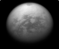
Posted by: titanicrivers Jun 7 2016, 12:27 AM
Nice Titan cloud monitoring images from Rev 236 http://www.ciclops.org/view/8365/Rev236?js=1 taken on June 4th at 1.5M km. The CL1 CB3 image is centered on Senkyo and is rotated so north is up where Kraken is visible (but not many clouds). Yalaing terra appears just below center looking much as it did before the Arrow storm of September 2010 http://www.unmannedspaceflight.com/index.php?showtopic=6738.
|
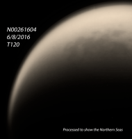
Posted by: titanicrivers Jun 11 2016, 05:04 AM
Cassini over the Northern Seas during T120
|
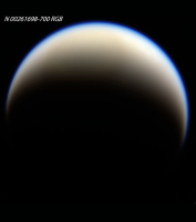
Posted by: titanicrivers Jun 12 2016, 05:37 PM
A June 10th haze monitoring RGB image from 1.38Mkm is shown below. A Celestia http://www.shatters.net/celestia/ program location grid is superimposed. The Solar System Simulator program http://space.jpl.nasa.gov/ was used to obtain the view of Titan from Cassini at the time the images were taken.
|
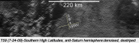
Posted by: titanicrivers Jul 30 2016, 11:31 PM
T 120 SAR images are highlighted in Photojournal http://photojournal.jpl.nasa.gov/catalog/PIA20708 . The labrynthine terrain shown in PIA20708 http://photojournal.jpl.nasa.gov/figures/PIA20708_fig1.jpg may be an extension of the similar terrain imaged during T 59 shown below.
|
Powered by Invision Power Board (http://www.invisionboard.com)
© Invision Power Services (http://www.invisionpower.com)