Printable Version of Topic
Click here to view this topic in its original format
Unmanned Spaceflight.com _ MRO 2005 _ May 23, 2007, HiRISE release
Posted by: AlexBlackwell May 23 2007, 04:01 PM
http://hiroc.lpl.arizona.edu/images/PSP/release_0027.php
Posted by: djellison May 23 2007, 04:10 PM
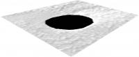
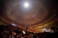
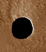
Ustrax - finally - you have what you asked for
http://hiroc.lpl.arizona.edu/images/PSP/diafotizo.php?ID=PSP_003647_1745
http://hiroc.lpl.arizona.edu/images/2007/details/cut/PSP_3647_1745_cut_b.jpg
THAT...is an abyss.
Doug
Posted by: ngunn May 23 2007, 04:12 PM
Well, just look at that great big hole in the ground !!!!!!!!!!!!!!!!!!!!!!!!!!!!!!!!!!!!!
Posted by: ustrax May 23 2007, 04:20 PM

THAT...is an abyss.


If I knew the service was so fast I could have ordered one http://www.unmannedspaceflight.com/index.php?s=&showtopic=4214&view=findpost&p=90492...

EDITED: A view:
|
Posted by: lyford May 23 2007, 04:59 PM
It's obvious that's an Acme Portable Hole that Wile E. Coyote left behind....
http://video.google.com/videoplay?docid=-569080467828405640
Posted by: Juramike May 23 2007, 05:12 PM
Wow!!!
Is that the entrance or exit? 
Posted by: nprev May 23 2007, 06:12 PM
 ..okay, THIS made my jaw drop! Why so circular? Almost looks like a meteor punched right through a thin surface crust & into a deep dark chamber (undoubtedly making the patented Wile E. Coyote as he goes off a cliff "bomb dropping" whistle all the way down in the thin Martian air...)
Either that, or we finally found the ejection end of the linear accelerator that launched H.G. Wells' invading cylinders... 
The imagination runs wild. If these things are really deep, you could have some interestingly high atmospheric pressure down there...
Posted by: djellison May 23 2007, 06:16 PM
Well - unless its many many km's - then there are other places which will have higher atmos.press at 'ground' level. But it's still a very very exciting and interesting feature
Doug
Posted by: stevo May 23 2007, 06:21 PM
Looks to me like one of Kim Stanley Robinson's Mars moholes.
Alternatively, we could extrapolate wildly from Titan and assume that anything that dark and featureless has to be liquidish, sort-of. Or not.
Posted by: hendric May 23 2007, 06:39 PM
I wonder what IR will show us, especially at night. I don't think we'll be able to look down the hole directly, unless MRO's orbit is modified, right? Maybe we need to wait for a nice, strong dust storm to kick up the tau, so that more light is sent down the hole from all around. Pretty amazing that it is pitch black!
I'm sure it's possible with to make an estimate of the minimum size and depth of the cavern based on that. Maybe we'll get lucky and something interesting will show up on IR, like the extent of the roof over the cavern. Do either of the radars on Mars have the resolution to check this out?
I don't quite understand why the incidence angle != angle of the sun above the horizon; only thing I can think of is that we're looking at a slope.
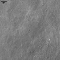
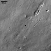
Anyone locate a wider context shot of that location? I couldn't see any lava-tube features, but the whole image might be one.
EDIT: Looks like this is Jeanne:
http://themis-data.asu.edu/img/browse/V18315002?band=3&stretch=S2
Took me a bit to convince myself it's the same location.
Posted by: ElkGroveDan May 23 2007, 07:20 PM
Can someone less lazy than I do the calculations on this? If we know the angle of the sun and the angle of this photo it should be easy to calculate a minimum depth for this chasm if we assume that sunlight illuminating the bottom of this hole would be visible in the image. Since nothing is visible, the depth must exceed that minimum.
Posted by: elakdawalla May 23 2007, 07:20 PM
See this topic for more information and links to context images from Odyssey:
http://www.unmannedspaceflight.com/index.php?showtopic=4036
--Emily
Posted by: AlexBlackwell May 23 2007, 07:24 PM
The excitement in this thread is one thing. Just wait till the kooks get wind of this image.
Posted by: volcanopele May 23 2007, 07:32 PM
Given this image's location on Mars, I would presume this is a skylight of an old lava tube. Very interesting though.
Posted by: tty May 23 2007, 07:43 PM
Yes, but it must be a very large tube since the hole is more than 100 meters across. I can't remember ever seeing a window into a lava tube that big on Earth. I wonder if lava tubes scale with gravity somehow.
Posted by: nprev May 23 2007, 07:48 PM
(groan)...don't remind me. I'm traveling now, but next week one of my consipiracy-minded co-workers is going to jump me on this for sure if it hits Hoaxland...at least he's retiring soon!
Posted by: AlexBlackwell May 23 2007, 07:54 PM
Who? Your co-worker or Hoagland?
Posted by: nprev May 23 2007, 08:08 PM
The former; maybe he's tight enough with the latter to persuade him to follow suit? </wishful thinking mode>
Posted by: djellison May 23 2007, 08:21 PM
38 degrees. Call it 130m across - sohcahtoa and all that - 101 metres is the cutoff at which we wouldn't see light at the bottom.
Doug
Posted by: elakdawalla May 23 2007, 08:22 PM
According to the caption on the image, though, HiRISE should be able to see deeper than that:
--Emily
Posted by: elakdawalla May 23 2007, 08:41 PM
Just for grins, I went to HRSCview and located the http://www.geoinf.fu-berlin.de/cgi-bin/ion-p?page=product.ion&code=81675006&image=0968_0000. Here's a crop from that:
|
I also noticed another skylight in the same HRSC view:
|
It doesn't look to me like that one's on the Cushing et al list (see my http://www.planetary.org/blog/article/00000984/ for that list and image). Or is it?
--Emily
Posted by: nprev May 23 2007, 08:53 PM
Nice find, Emily! Seems like it's right in line with that (apparent) collapsed lava tube to the upper right...
Posted by: Juramike May 23 2007, 10:06 PM
Ouch!
Am I the only one that didn't immediately see the pun??
GROAAAAAAAN!

Posted by: tuvas May 23 2007, 10:36 PM
Ahh, they finally released this picture. The one's got all of the scientists perplexed, we've come to a conclusion it's likely an overhanging of some kind, meaning that the lava tube is really big... I think we've figured it must be at least 200 m deep as well. Still, it's certainly quite a mystery.
Oh, for those of you wanting to overlay MOLA data, it's already been tried, without any luck.
Posted by: ElkGroveDan May 23 2007, 11:34 PM
Were any THEMIS images taken?
Posted by: tuvas May 23 2007, 11:35 PM
Of course, that's what prompted us to take the picture in the first place. Besides, THEMIS has photographed just about everywhere on Mars.
Posted by: ElkGroveDan May 23 2007, 11:38 PM
OK now I see the history of this with Odyssey. Sorry been out of the loop with assorted obligations the past few months.
Good to know. Mike has yet to impliment the Midnight THEMIS Browser
, so I haven't been able to keep up on that instrument either.
Posted by: dvandorn May 23 2007, 11:48 PM
Looks like a good landing site for MSL -- if it stood for the Mars Spelunking Laboratory...
-the other Doug
Posted by: antipode May 24 2007, 12:06 AM
Martian bungee jumping anyone?
Surely this will kick off a more systematic look at the slopes of the Tharsis and Elysium volcanoes, if it isnt already happening. Who know how many of these things might turn up, and who knows how big they might be? Hmmmmm, 0.38 gravity.....
P
Posted by: antipode May 24 2007, 02:08 AM
Actally, regardless of how deep these things are, at SOME time of the day at SOME time of the year (given their near equatorial location, around local mid day and around the equinoxes) the sun will illuminate the floors of these caverns. Being lucky enough to have an MRO overpass at one of these short periods is another matter of course...
P
Posted by: mchan May 24 2007, 03:20 AM
MRO is in sun-synchronous orbit so the nadir point below is either early morning or late afternoon local time to provide decent shadowing for most imaging. The orbit would have to be substantially adjusted to get a fly over noon local time.
What is the range of illumination angles due to seasonal variations from axial tilt?
Posted by: CosmicRocker May 24 2007, 04:55 AM
I took a hint from your discovery and started panning over that region with HRSCview, and I thought I saw several very small skylights that were not very convincing. I also came across the one you posted an image of, and then finally another apparently "new" one that was large enough to be convincing. It's actually a pair, but the second one is rather small.
|
Posted by: AndyG May 24 2007, 07:26 AM
Excellent. ~100m across? >200m deep? What a place to dome over and start building.
Andy
Posted by: ustrax May 24 2007, 09:36 AM
Is it really impossible to dig out something from the black?
http://s148.photobucket.com/player.swf?refURL=/&file=http://vid148.photobucket.com/albums/s18/spacEurope/Filme.flv&os=1&ap=1
What I did was an attempt to enhance some features that were already visible in the image shown http://hiroc.lpl.arizona.edu/images/2007/details/cut/PSP_3647_1745_cut_b.jpg on the right but that also come out from the http://hiroc.lpl.arizona.edu/images/PSP/diafotizo.php?ID=PSP_003647_1745.
Note: I know that it has already a name but Cernunnos, the Celtic God of Fertility, Life, Wealth and the Underworld sounded just perfect for the occasion...
Posted by: djellison May 24 2007, 10:22 AM
Yes - it really is impossible. That's not details - that's noise.
Doug
Posted by: zoost May 24 2007, 11:25 AM
Judging from the non-sense making overhangs visible in the picture, I vote for liquid.
Posted by: djellison May 24 2007, 12:12 PM
What sort of liquid at .006 bar and -80degC? Would a liquid not have specular reflection etc. Orbital images of lakes and seas on earth are not black. Do not confuse the 'black lakes' of Cassini Radar imagery with the optical wavelengths of HiRISE.
There is nothing nonsensical in the concept of overhangs. We see them on Earth - they could be even more extreme in the 1/3rd G of Mars.
Doug
Posted by: climber May 24 2007, 12:33 PM
I can't imagine anything else than a hole in a (lava) tube.
I don't remember the width of the path of MOLA. Somebody suggested that the depth can be find in the data. Is that possible?
Posted by: ngunn May 24 2007, 12:42 PM
Regarding that overhang:
We are told that the sun was 38 degrees above the horizon, or 52 degrees from zenith. This means that if the angle of overhang was less than 52 degrees from the vertical the sun would be directly illuminating part of the overhang wall surface underneath the visible rim. This would add significantly to the level of downward illumination inside, so my guess is it's not happening. That makes the angle of overhang quite severe and the rim quite thin. The direct sunlight entering through the skylight would then be falling on the floor of the cavern some distance down-sun. The light scattered from that bright spot would then be shining upward, illuminating the interior roof but not the part of the floor in our line of sight.
Posted by: djellison May 24 2007, 12:42 PM
^
"Oh, for those of you wanting to overlay MOLA data, it's already been tried, without any luck."
Doug
Posted by: zoost May 24 2007, 12:47 PM
There must be some liquids (carbon based) that absorb most /all visible light (independent of the light frequency). Is there any evidence that this hole is a hollow tube / entrance to a cave / ? Why is there no light on one of the walls?
Posted by: djellison May 24 2007, 01:02 PM
Because the ceiling is overhanging. It's a collapse to a lava tube. We've seen other hirise images that take this to the extreme just leaving a single piece over the top of the old lava tube - itself with overhanging edges (the 'bridge' picture). The mechanism behind a formation like this is certainly not that unusual and indeed terrestrial analogues are not uncommon either.
http://www.texasbeyondhistory.net/plateaus/images/ap17.html
We're looking almost straight down it - so in actual fact it wouldn't take that much of an overhang to mean we don't see the sides even if they're lit.
That opening is 11,000 sq m . If there were 11,000 sq m of an unusual liquid - CRISM would have found it and we'd know about it. It's 8 or so Crism pixels across.
Doug
Posted by: akuo May 24 2007, 01:16 PM
http://s148.photobucket.com/player.swf?refURL=/&file=http://vid148.photobucket.com/albums/s18/spacEurope/Filme.flv&os=1&ap=1
It's mostly noise, but on the scale of the whole hole, the upper part of the circle is lighter than the lower part. This might be the floor showing.
They just need to increase the exposure time for the next pass.
Posted by: ustrax May 24 2007, 01:17 PM
Thanks Doug, not even a tiny single chance?
I've justaposed what I got to the original image and that damn noise has the ability to act as if following some features in the contour of the rim...


|
Posted by: djellison May 24 2007, 01:19 PM
I'm not saying that you're not pulling out three different shades from an 8 bit greyscale image, for which some photons from the bottom my be responsible. I'm saying it's impossible to say "that's the bottom". Lest we forget, similar techniques turned a black dunefield into all sorts of things.
I'm not sure that HiRISE can take longer exposures - 4x4 binning might help but of course we can do that with the image on the ground already
Doug
Posted by: ustrax May 24 2007, 02:04 PM
Lest we forget, similar techniques turned a black dunefield into all sorts of things.
Neither am I, I was not saying "look how dark is the bottom, it might even be a pond!"
I was focusing on the "walls"...
For now...
The problem of that dunefield was being a dunefield, let's remember that the techniques applied to Ultreya were accurately developed specifically to deal with an abyss...
EDITED:
Yes, I found that curious because it seems to be an extension of the disturbed lighter soil patch outside the hole:
|
Posted by: akuo May 24 2007, 02:21 PM
Binning done in the electronics before AD transformation is a lot more effective than in software, and I think this is what they talk about when some Hirise image is 2x2 binned etc.
Increasing is exposure time is of course problematic because Hirise has a scanning type detector. It will be interesting to see what the future plan is.
Posted by: centsworth_II May 24 2007, 02:40 PM
Will we have to wait until there is a laser altimeter or radar that can look to the bottom? How soon
can that be? I'm guessing a camera sensitive enough to see down there would not be worth it.
Posted by: Tesheiner May 24 2007, 03:30 PM
True. But we had good times imagining what "those sort of things" might be.
Posted by: Juramike May 24 2007, 04:10 PM
It's not an abyss, it's a martian oubliette!
And when we finally get illumination down there we'll find both Mars Polar Lander and Beagle 2 at the bottom!
( "My God, I see stars....")

[This image has totally tickled me pink. Aside from it's sheer image impact, a collapsed lava tube is a great way to get a peek at relatively protected Martian basalt.]
-Mike
Posted by: Gray May 24 2007, 04:25 PM
Perhaps we could we could use the name 'Cernunnos' for the underground chamber(s) for which there may be more than one entrance.
Posted by: Stu May 24 2007, 04:43 PM
Maybe one day...
|
Posted by: tuvas May 24 2007, 08:14 PM
MRO flight rules limit the off-NADIR pointing to 30 degrees. But that's only 24 degrees difference, it might allow one to see the bottom of the cave. It would almost certainly allow seeing the wall of the cave. Still, this is turning to be a highly unusual feature.
Oh, SHARAD might be able to find the depth of the cave, I'm just guessing though.
Also, you might be interested in knowing that the HiRISE team talked about the cave in a HiOPs meeting last Monday, we were joking that MSL should repel down into the cave, and then we thought, well, it can already repel, skycrane... Hmmm...
Posted by: ustrax May 25 2007, 08:08 AM
Regarding the "work" I've done with the image, Alfred McEwen told me that it may be "scattered light", "the camera optics are excellent but not perfect."
But, might I add, the closest to perfection I have ever seen...
Posted by: ngunn May 25 2007, 09:01 AM
Thinking about the possible pattern of illumination in the cavern made me think again of that wonderful Pantheon photo. The patch of sunlight in this case might be falling on a horizontal floor, but more likely somewhere part way up one sloping side of the tunnel, thus preferentially illuminating the opposite side with scattered light. I have a sketch of the geometry which could produce the apparent slight grading in interior illumination that may be showing on that image, but unfortunately no easy way of posting it here.
Posted by: ngunn May 25 2007, 10:01 AM
Am I the only one that didn't immediately see the pun??
GROAAAAAAAN!
Actually you saw it before me, so - it was all in the eye of the beholder! (Maybe a case of the pot calling the kettle black? How appropriate.)
By the way I'm going to be incommunicado for a few days - probably just as well.
Posted by: ustrax May 25 2007, 01:47 PM
I've made a http://s148.photobucket.com/player.swf?file=http://vid148.photobucket.com/albums/s18/spacEurope/Cernunnos2.flv&os=1&ap=1 focusing on the top-right quadrant.
Noise? Scattered light?
I just love the way the appearing features, layers-like, matching so nicely with the rim, seem to belong there...
Posted by: tedstryk May 25 2007, 03:03 PM
Perhaps they could rotate the spacecraft to compensate for motion, allowing longer exposure times (same principle as CPROTO with MOC, but using the reduced speed at which the surface goes by for longer exposure time per line instead of higher resolution. Would be difficult, but worth trying once if at all possible.
Posted by: marswiggle May 25 2007, 03:23 PM
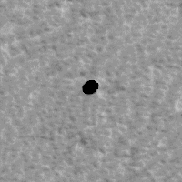
I had a quick look in the MOC Gallery for similar features around the Arsia flanks and happened to find these. The first one is clearly Dena, from http://www.msss.com/moc_gallery/r03_r09/images/R08/R0800159.html. The second one is from http://www.msss.com/moc_gallery/s05_s10/images/S09/S0901483.html (lower right of the narrow angle img), and AFAIK it has not been referred previously. Both images are full size crops from the gif files, so I think the sizes are ~about~ proportional. The second one certainly could be an artefact, but it is very similar to the other ones anyway. A thorough search in the MOC imagery could reveal more.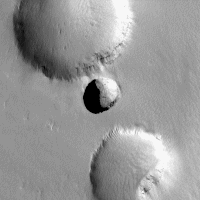
Posted by: ustrax May 25 2007, 04:15 PM
They may not know yet what happened to their loved one but let's have some respect by http://i16.photobucket.com/albums/b14/ustrax3/bwwn.jpg privacy...
Posted by: nprev May 25 2007, 05:05 PM
Wait a minute, ustrax...are you sure that's not actually their home?
Posted by: Gray May 25 2007, 05:22 PM
Marswiggle,
The image of Dena that you posted has much better resolution and lighting than the image published in the Cushing, et al. paper (http://www.lpi.usra.edu/meetings/lpsc2007/pdf/1371.pdf).
Are we actually seeing the bottom of the pit in that one?
Posted by: marswiggle May 26 2007, 11:30 AM
While I don't know, let them answer, in that very report:
MOC observation of Dena at ~2 p.m. (R0800159)
actually does show an illuminated floor, allowing us to
tightly constrain the depth using a 1-D photoclinometry
routine. This routine returns a depth of ~130 m for
the illuminated floor, while the minimum depth estimated
from the THEMIS observation is only ~80 m.
Because THEMIS IR observes at 100-m resolution,
cavern skylights with diameters much smaller
than that are probably not thermally distinguishable
from regular temperature variations on the surface
(The last paragraph also explains why the possible new skylight in S0901483 has not been observed with THEMIS, it evidently and perceivably being less than 100 m in diameter.)
Posted by: Gray May 26 2007, 02:01 PM
Thanks.
I should do more than look at the pictures. 
Posted by: tty May 26 2007, 06:31 PM
130 meters deep, that is really something for a lava tube. I've tried to find out what the maximum diameter of lava tubes on Earth is and the largest figures I have found is about 40 meters. However I remember seeing a considerably larger collapsed tube on Iceland so very likely it is the high gravity that limits the diameter.
When it comes to lengths, tubes here on Earth can extend many kilometers. Interestingly the longest seem to be on Hawaii (sensu stricto) which of course is the largest shield volcano complex on Earth, so on Mars' vastly larger shield volcanos tubes might very well be hundreds of kilometers long!
A tube 200 km long and 200 meter in diameter, how about that for an underground habitat?
Posted by: Stu May 27 2007, 09:48 AM
What's causing that lighter area to the top of the hole?
|
Is wind coming up out of the hole? If so, that could suggest caverns linked by a tunnel network around here, maybe?
Does anyone else think the ground in this lighter area looks more rippled (duned?) than the other terrain?
Posted by: dvandorn May 27 2007, 10:08 AM
Actually, Stu, I think the lightened area looks roughly the same in terms of the extent of duning as the rest of the surrounding terrain. It looks more to me like the lightened area has seen more deposition than the surrounding terrain -- the underlying lava-flow surface is more muted and softened in the lightened area.
I think what's happening here is that the prevailing winds are coming from the bottom of the image. As they pass over the hole, the air sinks a bit, and winds strike the rim of the hole along the top arc (all directions -- top, bottom, etc. -- relate to the orientation of your posted image). So the top arc of the rim is being eroded a little more rapidly than the rest of the rim, and the erosion product (basaltic dust, most likely) has been deposited on the ground beyond the top rim arc.
It's also at least somewhat possible that winds are entering the hole, swirling around, eroding the interior of the lava tube, and blowing dust out from the cavern and onto the ground above the top rim arc. I just don't think that Martian winds are powerful enough to reach into such a deep hole and scoop dust out of it, but I could be wrong. At any rate, it's impossible to model airflow into and out of that hole without having a decent idea of the size and shape of the empty lava tube, and we really have no way of determining that...
-the other Doug
Posted by: Stu May 27 2007, 10:21 AM
Ok, just me then!
I did think first about airflow over the crater being responsible for the change in brightness, but I can't help wondering if there are other - smaller, so as yet unseen - holes in this area and they're all linked together... would that allow winds to be generated within a tunnel network leading to a higher-than-usual speed for winds coming up out of a hole like this? Please, no-one cuff me around the ear for asking that if it's impossible or stoopid, I'm just thinking aloud...
And talking about smaller holes... anyone taken a closer look at these dark spots?
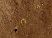
|
No sign of lighter "streaks" above them, so maybe I'm just seeing holes that ain't there... or maybe they are holes that just aren't big enough to generate much airflow...
As I said, just thinking aloud...
Posted by: djellison May 27 2007, 11:38 AM
I doubt it's wind through the lava tube itself. Think of a crater - that can have a dust tail of some sort and there's no network to do that. I imagine it's just a function of prevailing wind and topography. Wind blowing over a lage flat area suddently finding a big hole is going to get chucked up a bit - you might even find that the area under the hole is at a slight negative pressure relative to the surrounding area because of it.
Another thought - given that this tube is beginning to collapse at this one obvious site and potentially many others, it's quite likely that the tube itself isn't much of a tube anymore and more like a range of adjacant chambers. Who knows...I can't imagine we will for a few decades.
Doug
Posted by: Stu May 27 2007, 03:13 PM
True... but fun to imagine...
HOLE TRUTH
Look at that beckoning circle of black.
Darker than a dying sharks eye,
a hole cut out of Mars ancient hide
revealing nothing. Nothing At All.
No light falls on the far-below floor;
this is not a doorway but a pit
and deep inside it secrets lie in wait.
No world beneath is glimpsed
through this perfectly-punched puncture
in the planets brittle crust; just
more black, more emptiness,
a lack of everything is all we see
beneath this round-rimmed void.
Its as if one of Saxs laser beams
screamed from the salmon sky
and bored into Barsoom right here,
cauterising the wounded, light-seared
land but more likely a giants hand of a meteor
smashed through the stone to the underworld
below, where no sol-light has ever shone
and millennia of darkness have passed
in cold, silt-softened silence.
Once lava, scarlet as Saurons eye ran
under here in smoking smears; for years
red and orange rocky vomit belched
through countless corridors of heat-and light-
baked stone yet this one alone has been revealed,
its shielding ceiling stabbed through by
who knows what. All we know is that all
are cold now, weaving and meandering
beneath these badlands like dust-clogged
arteries running through a mummys corpse.
If I stood shaking on its crumbling ledge,
daring to gaze oer the edge of this abyss,
what blissful wonders would I see?
With my torch beam slicing through the gloom
would I swoon at the sight of stalactites
jabbing down like serpents teeth
from the ground beneath my feet?
Or on the shadowed floor far far below
would my sweeping light ray show
a carpet of pastel-paint hued life?
Enough streaks and plumes of green and blue
to make some cry I KNEW it!
Or would a Balrogs fetid breath blow
over me before I felt its flaming whip
grip my ankle and drag me to my doom..?
© Stuart Atkinson 2007
Posted by: nprev May 27 2007, 03:58 PM
Chilling yet fascinating, Stu...really captures the ominous feel/excitement of what it might be like to stand near the edge of one of these things...well done!
Posted by: tty May 27 2007, 05:30 PM
I think the two elongated black spots with white rims in the 11 o'clock position from the big hole look like better candidates.
Posted by: J.J. May 28 2007, 03:12 PM
That. Is. Incredible.
Interesting, how this one image has completely usurped the others in the press release. It's interesting to speculate on what's it's like inside...I wonder if the floor has a thick coating of dust from (perhaps) eons of storms. Any way you slice it's, it's a beautiful image.
P.S.--Groovy poem.
Posted by: tuvas May 28 2007, 05:22 PM
It's interesting, not since the Victoria crater picture has a HiRISE picture gathered so much interest as this one. And that's the only one that I know of that has surpassed the interest in this picture of any one image we have taken. Kind of funny how that works out sometimes.
Posted by: Oersted May 30 2007, 10:55 AM
Good one thinking of my photo, I didn't even do that, but yes, there are definitely similarities in the spatial lay-out!

Something like this?

My "Pantheon - Earth and Moon-page":
http://www.dalsgaard.eu/Pantheon/
Posted by: bdunford Jun 1 2007, 06:04 PM
I don't know if this is news to anyone, but FWIW, after a similar amount of interest about this image on my site, I asked the MRO team for some more info, and received this reply from Nathan Bridges on the HiRISE team, via Suzanne Smrekar:
"1. Yes, HiRISE is planning to image this again. We can't do much about the Sun angle because MRO's orbit is close to 3:00 P.M. and we are near the equator. Seasonal variations mostly affect the solar azimuth at this latitude, not the angle above the surface. However, we can change the angle that MRO looks at the target. So, for our 2nd observation, we will do a large roll to the east in the hopes of seeing the west-facing wall.
2. The two prevailing hypotheses is that this feature is either a deep collapse pit or a "skylight" ( opening) into an ancient lava tube. The location is between Pavonis and Arsia Mons, two large shield volcanoes, so a volcanic origin is appealing."
Posted by: Juramike Jun 1 2007, 07:12 PM
What would it sound like next to the hole? Would it whistle in the wind?
How fast would the wind have to go past the hole to get any sound at all?
(High frequency or low frequency? How would it compare to a similar setup on Earth? Is the frequency dependant on the absolute depth and inner structure?)
Any wild guesses?
-Mike
Posted by: ngunn Jun 4 2007, 09:55 AM
Yes, and thanks for the additional image. The only difference between this and my sketched geometry is that I have replaced the spherical internal shape of the Pantheon with a horizontal cylinder representing the inferred lava tube. The internal illumination pattern then depends on the azimuth difference between the illumination direction and the cylinder axis, as well as the sun's altitude.
Posted by: AlexBlackwell Jun 18 2007, 08:47 PM
http://planetary.org/radio/show/00000241/
Planetary Radio
Monday, June 18, 2007
Posted by: ustrax Mar 19 2009, 08:24 PM
Wow! They were able to actually get the bottom of a pit out of the dark!
http://www.universetoday.com/2009/03/19/hirise-looks-down-to-the-bottom-of-a-pit-on-mars/#more-27497
Nothing new here...done it two years ago...
http://www.unmannedspaceflight.com/index.php?s=&showtopic=4220&view=findpost&p=90761
Powered by Invision Power Board (http://www.invisionboard.com)
© Invision Power Services (http://www.invisionpower.com)