Printable Version of Topic
Click here to view this topic in its original format
Unmanned Spaceflight.com _ MRO 2005 _ MRO-HiRISE
Posted by: JohnVV Mar 29 2016, 12:03 AM
last Friday Phil Plait over on " Bad Astronomy "
posted a cool image
http://www.slate.com/blogs/bad_astronomy/2016/03/25/conical_structure_on_mars_in_a_sand_dune_field.html
it took the weekend to process all 18 HiRISE red ccd images into one mapped image ( 1.3 gig )
then run a SFS on it , well a crop but still 8192x8192 image
http://imgbox.com/gRItQCbn
reduced size ( 2048x2048 mesh ) test renders in Blender
http://imgbox.com/PbwT2oNU http://imgbox.com/2ZwDYlMp http://imgbox.com/0grOu1KG http://imgbox.com/YuLUaYNf
http://imgbox.com/N4Bd3nau http://imgbox.com/On6EuK3B http://imgbox.com/pTCIykFg http://imgbox.com/mmoDPsC0
Posted by: JohnVV Mar 31 2016, 01:02 AM
higher resolution mesh and slightly recolored B&W red HiRISE image
http://imgbox.com/MwbSQiUr http://imgbox.com/bE4BuAIZ
Posted by: Sean Jan 5 2017, 07:40 PM
Here is a selection of renders from recent HiRISE DTM's...
Software;HiVIEW/Blender/Max/Photoshop
Uzboi Vallis
https://flic.kr/p/PHeZYR
https://flic.kr/p/QTnAN1
Noctis Labyrinthus
https://flic.kr/p/QL8Ayi
https://flic.kr/p/PH1BtB
https://flic.kr/p/QL8FG4
https://flic.kr/p/PH1Nvg
Elysium Planitia
https://flic.kr/p/QVLj7X
https://flic.kr/p/PGbAXx
Posted by: scalbers Jan 5 2017, 11:38 PM
Really nice renders Sean! With this I can imagine rover visits to each of these places. Would be interesting to see where you are in Noctis Labyrinthus relative to the context say from some Viking images that I recall.
Posted by: Sean Jan 6 2017, 02:57 AM
Thanks Steve...http://www.uahirise.org/PSP_009118_1665 is the location...
and a test flight...click on the image to see the video.
https://flic.kr/p/PF7NAY
*edit*...and another of the same area, click thru to see the video...
https://flic.kr/p/QXUxCX
Posted by: Sean Jan 6 2017, 10:56 AM
http://www.uahirise.org/PSP_006788_1955
https://flic.kr/p/PFCAKJ
https://flic.kr/p/QUxHRy
https://flic.kr/p/PFCBUh
https://flic.kr/p/QUxHou
Posted by: Sean Jan 6 2017, 01:06 PM
http://www.uahirise.org/dtm/dtm.php?ID=ESP_017173_1715
HiRISE data parsed by HiVIEW, Blender, Max, Photoshop & After Effects
https://flic.kr/p/QJZdSL
https://flic.kr/p/PJxrpR
https://flic.kr/p/PJxr9F
https://flic.kr/p/QJZdm5
https://flic.kr/p/PJxqEz
https://flic.kr/p/PJxqrP
https://flic.kr/p/QJZcLN
https://flic.kr/p/QY8mHz
https://flic.kr/p/QJZcrQ
https://flic.kr/p/QY8mh4
Posted by: Sean Jan 6 2017, 01:08 PM
last two for this batch...
https://flic.kr/p/QJZc9W
https://flic.kr/p/QY8kWK
Posted by: charborob Jan 6 2017, 05:06 PM
How much vertical exaggeration is there in your renderings?
Posted by: Sean Jan 6 2017, 06:31 PM
None. This is straight from the DTM.
Posted by: scalbers Jan 6 2017, 06:42 PM
Indeed glad you are faithful to the terrain - and besides vertical exaggeration wouldn't be needed anyway!
One thing that might be worth a try sometime is the inclusion of scattering by atmospheric dust, depending on how much in the way of the optical parameters can be included in the rendering software.
Posted by: Sean Jan 6 2017, 06:49 PM
Its on my list Steve, this initial splurge was spent optimizing the workflow. I managed to shave a few hours off!
Posted by: HSchirmer Jan 6 2017, 07:32 PM

https://flic.kr/p/QY8kWK
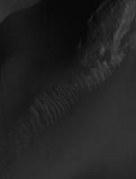
Wow, amazing razerback ridges emerging from the dunes.
Anybody else reminded of a voice over from Ricardo Montalban
"these are the last indigenous residents of Ceti Alpha 5...."
Posted by: Sean Jan 6 2017, 07:40 PM
http://www.uahirise.org/PSP_006788_1955
Click on the image to see the video...
https://flic.kr/p/PK6FjF
Posted by: Habukaz Jan 6 2017, 09:42 PM
It's Uzboi - I know that place.

I'm used to looking at a lot of HiRISE images, and with that perspective, the first one in colour looks spectacular (and they are all quite informative - something to keep in the back of my mind the next time I look at related 2D images).
Posted by: Sean Jan 6 2017, 11:56 PM
I'm used to looking at a lot of HiRISE images, and with that perspective, the first one in colour looks spectacular (and they are all quite informative - something to keep in the back of my mind the next time I look at related 2D images).
Uzboi? Geez...so many files spelt incorrectly....thanks for the correction, post updated.
Here is a clip of the http://www.uahirise.org/ESP_017173_1715
Click on the image to see the video...
https://flic.kr/p/QVEVUw
Posted by: Sean Jan 7 2017, 04:48 PM
http://www.uahirise.org/dtm/dtm.php?ID=ESP_014081_1440
https://flic.kr/p/Qr9QSQ
https://flic.kr/p/R1ipAB
Click the image to see the video...
https://flic.kr/p/PLBxKB
HiRISE data parsed by HiVIEW, Blender, Max, Photoshop & After Effects
Posted by: Sean Jan 8 2017, 03:14 AM
http://www.uahirise.org/dtm/dtm.php?ID=PSP_002932_1445
HiRISE data parsed by HiVIEW, Blender, Max & Photoshop
No vertical exaggeration.
https://flic.kr/p/QQLLzn
https://flic.kr/p/PMBiuB
https://flic.kr/p/R2e9bk
https://flic.kr/p/QXQYy7
Posted by: nprev Jan 8 2017, 10:10 AM
These are just spectacular. I hardly know where to begin. Thank you VERY much, Sean. 
Posted by: Sean Jan 8 2017, 03:31 PM
Thank you very much, I'm having a LOT of fun making these.
I will be introducing scale reference into the images and here is a sample from the next video I will upload soon...
https://flic.kr/p/PKSqfo
https://flic.kr/p/QYZmCW
Posted by: Sean Jan 8 2017, 07:55 PM
http://www.uahirise.org/dtm/dtm.php?ID=PSP_002932_1445
Here is the video with an Astronaut scaled to the model... Click thru to check it out.
https://flic.kr/p/PP6CpZ
As usual...no vertical exaggeration.
Still lots to improve on... atmosphere, colour, animation etc.
DTM suggestions welcome.
Posted by: scalbers Jan 8 2017, 08:29 PM
Thanks Sean for really advancing things on how we can view Mars. As for DTM suggestions one can consider a helicopter style view following the tracks of Curiosity, Spirit, and Opportunity?
Another one (unless you've done this) would be in Valles Marineris, harking back to a passage from Cosmos where Carl Sagan narrates a fly through animation poetically saying "...careening through the corridors of the Valley of the Mariners"
Posted by: Sean Jan 8 2017, 08:44 PM
Thanks Steve... I love that Carl Sagan idea!
I'm currently working on a Curiosity shot so watch this space!
Posted by: HSchirmer Jan 8 2017, 10:18 PM
As usual...no vertical exaggeration.
Still lots to improve on... atmosphere, colour, animation etc.
DTM suggestions welcome.
Astrid, A Princess of Mars...
ala Edgar Rice Burroughs
http://www.erbzine.com/mag14/1438.html

Posted by: Sean Jan 9 2017, 10:58 AM
More Mounds... these are rendered at full available fidelity in the model and texture to determine qualitative difference compared to the previous 'optimized' versions.
https://flic.kr/p/QQL89S
https://flic.kr/p/R4Ut6K
https://flic.kr/p/R4UsU2
Posted by: jasedm Jan 9 2017, 07:57 PM
Seconded. These are phenomenal.
I particularly like the lack of vertical exaggeration.
Thanks Sean.
Posted by: Sean Jan 9 2017, 09:45 PM
Thanks, I'm glad you are enjoying them.
If you are familiar with a nice location covered by DTM then please let me know and I will see if Astrid will pay a visit.
Posted by: dtolman Jan 10 2017, 03:12 AM
https://www.nasa.gov/feature/jpl/earth-and-its-moon-as-seen-from-mars
SE Asia, Australia, and Antartica are in view. A calibration image taken November 2016.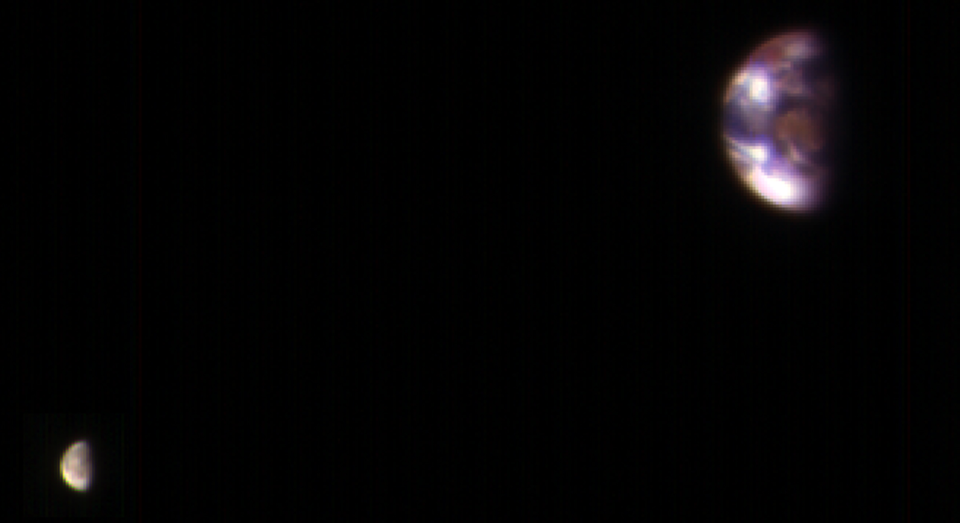
Posted by: Sean Jan 10 2017, 02:41 PM
http://www.uahirise.org/dtm/dtm.php?ID=ESP_016213_2315
https://flic.kr/p/QwLFZC
https://flic.kr/p/QVtSLV
https://flic.kr/p/PPDWtw
https://flic.kr/p/R6XNmk
https://flic.kr/p/PSn5RD
Posted by: Sean Jan 10 2017, 10:40 PM
Here is a video from the same location as the previous post...
https://flic.kr/p/PT1PXV
Posted by: Sean Jan 11 2017, 10:50 AM
There is a to-scale astronaut in the following image...
https://flic.kr/p/R8nFev
Posted by: Ron Hobbs Jan 11 2017, 06:48 PM
Found her!
Thanks for this challenge. Great way to inspect this incredible terrain. (Or should that Arerrain?)
Posted by: Sean Jan 12 2017, 12:49 AM
So it turns out that this area is Domoni crater and the nice folk at PIRL let me know that HiRISE had full coverage so I was able to extend the scene in 3D to provide the following images...
https://flic.kr/p/QzbNub
https://flic.kr/p/R9pU4t
https://flic.kr/p/PUPS2e
using these assets...
http://www.uahirise.org/dtm/dtm.php?ID=ESP_016490_2315
http://www.uahirise.org/dtm/dtm.php?ID=ESP_016846_2320
http://www.uahirise.org/dtm/dtm.php?ID=ESP_016213_2315
Posted by: vjkane Jan 12 2017, 02:15 PM
Thank you for sharing these!
Posted by: Sean Jan 13 2017, 01:57 PM
Click thru for a video tour of Domoni Crater...
https://flic.kr/p/PUsumd
Posted by: Sean Jan 13 2017, 09:37 PM
http://www.uahirise.org/dtm/dtm.php?ID=PSP_002878_1880
https://flic.kr/p/QC9gVm
https://flic.kr/p/R8Z2LU
https://flic.kr/p/QYcYEJ
https://flic.kr/p/PV39Vw
https://flic.kr/p/R1QU1g
https://flic.kr/p/QC9nWj
https://flic.kr/p/R1QXG4
Posted by: Sean Jan 14 2017, 07:54 AM
http://www.uahirise.org/dtm/dtm.php?ID=PSP_002878_1880
Click thru for the video...
https://flic.kr/p/R2sDYg
Posted by: PaulH51 Jan 14 2017, 08:56 AM
These are great Sean, have subscribed to email alerts this sub-forum so I dont miss any
Fingers crossed there is enough data that will enable you to create a few of Gale crater. If I could be permitted to throw an idea your way, maybe one of the entire path from landing from an elevated camera position, with tags on the ground for the rovers position every 50 sols or so? (just thinking out loud)
Probably a big ask
Posted by: Sean Jan 14 2017, 09:56 AM
Fingers crossed there is enough data that will enable you to create a few of Gale crater. If I could be permitted to throw an idea your way, maybe one of the entire path from landing from an elevated camera position, with tags on the ground for the rovers position every 50 sols or so? (just thinking out loud)
Probably a big ask I'm working on Gale but its a big job and I want to do it justice... I'm filing the edges off the workflow with these posts.
Posted by: Sean Jan 14 2017, 09:59 AM
Can you spot the astronaut in this image?
https://flic.kr/p/QYVXZS
( Answer is in the subsequent image on Flickr )
Posted by: Sean Jan 15 2017, 02:46 PM
http://www.uahirise.org/dtm/dtm.php?ID=PSP_010301_2200
https://flic.kr/p/Q1GAfn
https://flic.kr/p/R27sgj
https://flic.kr/p/R27rTL
https://flic.kr/p/RfmfCM
https://flic.kr/p/PXXxcN
https://flic.kr/p/RbUAao
Click thru for a video...
https://flic.kr/p/RbXjPs
Posted by: scalbers Jan 15 2017, 03:17 PM
Amazing how much detail there is in all of these DTMs that Sean is bringing to life. I'm curious about what the brighter material is near some of the higher terrain. Nice to see an atmosphere showing up in the background. I wonder if future plans might also consider the effects of the atmosphere between the observer and the terrain?
Posted by: Sean Jan 15 2017, 03:56 PM
Its on the list Steve. Although given the limited coverage of the area I wonder how much atmos to add.
Posted by: scalbers Jan 15 2017, 04:28 PM
Interesting question Sean. For a ballpark answer I would suggest that we can estimate an overall optical depth tau (~0.5) and dust scale height of 11km. This means the extinction coefficient at elevations near the ground would be 0.5/11km or 4.55 * 10^-5 m^-1 (tapering off exponentially as we go upward). From this both the inscatter and outscatter can be determined in the path between the observer and point on the terrain.
The impact might be subtle in the foreground, though becoming more noticeable for distant features in the background when looking near the sun.
Posted by: Sean Jan 15 2017, 05:05 PM
Thanks for your response Steve. Horizon haze is on the to do list as a priority.
Posted by: Sean Jan 16 2017, 05:25 PM
http://www.uahirise.org/dtm/dtm.php?ID=ESP_030715_1440
https://flic.kr/p/Q1aGgo
https://flic.kr/p/R71yAe
Posted by: Sean Jan 17 2017, 07:46 AM
Here is a still from a forthcoming animated tour of Hale Crater Hills.
https://flic.kr/p/QJnqAA
Added some atmospheric scattering.
Posted by: Sean Jan 17 2017, 07:39 PM
Another one from Hale Crater Hills...
https://flic.kr/p/Q57eei
Posted by: scalbers Jan 18 2017, 12:32 AM
Great to see this realistic atmospheric effect!
Posted by: Sean Jan 18 2017, 01:02 AM
Thanks Steve... I figured out a way to automate/bake it into the workflow so it should help a lot with future images. More work to be done on the skybox.
Posted by: Sean Jan 18 2017, 06:36 AM
http://www.uahirise.org/dtm/dtm.php?ID=ESP_030715_1440 http://www.uahirise.org/dtm/dtm.php?ID=ESP_030715_1440
Click thru to see the animated tour in 4k...
https://flic.kr/p/Rkj5wi
Stitched together from 2 DTM's.
Posted by: PaulH51 Jan 18 2017, 01:14 PM
Can't get enough of these....
Posted by: Sean Jan 19 2017, 12:11 AM
Hale Hills oblique...
https://flic.kr/p/Q58WJG
rendered at 20000 x 10000
Posted by: jasedm Jan 19 2017, 06:57 PM
To re-iterate, these are simply spectacular Sean - almost Ansel-Adamesque. Thanks for sharing them.
Posted by: Sean Jan 19 2017, 07:25 PM
Thank you, quite addictive making them! The data is amazing...these renders are optimized to run on my machine so there is room to squeeze a little more detail out. There are lots of 'improvements' on the way...sky, colour and hopefully some kind of contextual compositional solution, if I can get my head around the myriad sources!
Posted by: Art Martin Jan 19 2017, 11:31 PM
I understand the addiction. Years back when I was knee deep in the Microsoft Flight Simulator I found that users could add photorealistic scenery to areas and found DEM files from NASA and aerial photography shots from my county and combined them together to make the Phoenix area I was always flying over more realistic. The results were stunning. Suddenly the mountains and riverbeds looked exactly like reality and I began creating 3d buildings and objects, taking photos of their exteriors and wrapping them over the vertices. I spent months adding more and more. It eventually ended up a side business as people convinced me others would buy my work. It never was about the profit though. Was about the creativity it unleashed. A major addiction when it all comes together. Your work is wonderful.
Posted by: Sean Jan 20 2017, 11:30 AM
Thanks for the story Art and given that your compliment means a lot!
I suppose it has something to do with making these inaccessible places tangible in some way, there is a visceral thrill when the elevation data & satellite imagery come together. Suddenly it is a place.
Here is a best quality available video of RGB pass from the Mounds in Ganges Chasma...
https://flic.kr/p/RcZY1X
Posted by: Sean Jan 20 2017, 01:08 PM
Now able to render at full available texture resolution!
A small breakthrough which might only result in a tiny perceptible qualitative improvement given compromises on elevation data...
https://flic.kr/p/RkoGKd
...shots closer to models would hold up better though.
Posted by: Sean Jan 20 2017, 11:13 PM
Here is RGB data mapped to 3D model to show parallax...
https://flic.kr/p/QQfhHu
Posted by: Sean Jan 23 2017, 02:27 PM
Culled this animation from a 9 DTM strong swathe of Mt Sharp... too wieldy to be productive yet so the following uses only 1 DTM
click thru to see the video...
https://flic.kr/p/QcKTK1
http://www.uahirise.org/dtm/dtm.php?ID=PSP_009149_1750
Posted by: Sean Jan 23 2017, 07:25 PM
Hematite Ridge portrait
5 DTM's at full texture res, 12k x 6k work in progress so please forgive the misalignment!
https://flic.kr/p/Rr8ZcW
Posted by: Sean Jan 23 2017, 08:16 PM
Sharp Slope
Click thru for the video...
https://flic.kr/p/RrdrCJ
Posted by: Sean Jan 24 2017, 12:05 PM
Here is a link to a 450 megapixel test render of
http://www.gigapan.com/gigapans/195470
over at Gigapan.
Rendering at this level shows up some errors in alignment & textures ( not loading ) but is a good prep for upscaling to 65k pixel output
Posted by: climber Jan 24 2017, 09:15 PM
Any chance you point out where's Oppy or where she'll enter the scene? Thanks
Posted by: Sean Jan 24 2017, 09:24 PM
Here is a link to another Gigapan 450 megapixel extravaganza...
http://www.gigapan.com/gigapans/195482
And the Flickr version...
https://flic.kr/p/Ri6Hmf
I was quite aggressive culling the DTM borders to conform to the chosen viewing angle.
Lots of work in Photoshop to balance out the jigsaw of exposures.
Each of the 5 DTM's were rendered separately, the foreground render then acted as a guide for conforming the rest to the base Mt Sharp render which is visible in the background crater rim and the upper left of the image. A depth pass was used to introduce atmosphere and soften transitions.
An amazing dataset!
Posted by: scalbers Jan 24 2017, 09:35 PM
I've had some luck studying these with the route maps and another site where you can zoom into HIRISE (though it is offset a bit): http://curiosityrover.com/rovermap1.html
I can surmise for Curiosity that it will enter soon at the right edge of Sean's neat Hematite Ridge rendering, about 40-45% of the way between top and bottom.
Posted by: Sean Jan 24 2017, 09:52 PM
You mean Curi, surely?
In the most recent Gigapan you can see Murray Buttes at the bottom center right of the image, tracing the route up toward the natural break in the dune field to the left of Ireson hill you can almost discern a path leading up to Hematite Ridge. In time I will make a version with the notional route.
In the first Gigapan rendering, Hematite Ridge, Curi's current position near Ireson Hill is just above the center stage right.
I can surmise for Curiosity that it will enter soon at the right edge of Sean's neat Hematite Ridge rendering, about 40-45% of the way between top and bottom.
Posted by: climber Jan 25 2017, 07:57 AM
Thanks and haha! Yes Cury, don't ask me why? May be Oppy=hematite for the last 13 years 
Posted by: vjkane Jan 25 2017, 02:59 PM
The Gale Crater movie is perhaps the most awesome rendering of planetary image data I've seen. Thank you! It really brought the places Curiosity is exploring to life, which the overhead images don't.
If you ever have the time and inclination, it would be fascinating if the movie could retrace the Rover's journey.
Posted by: Sean Jan 25 2017, 09:39 PM
Thanks vjkane, although to be fair there have been awesome animations using the same data over on Youtube since 2010.
I do have a nice 4k animation cooking at the moment but its going to take a while before it is ready.
In the meantime here is another take on the HiRISE coverage of Mt Sharp...
https://flic.kr/p/Ry4kMv
and the 450 megapixel Gigapan version...
http://www.gigapan.com/gigapans/195525
Posted by: nogal Jan 25 2017, 10:21 PM
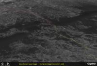
I grabbed a crop of Sean's "Mount Sharp Northwest Flank" (from Gigapan) and roughly marked Curiosity's route up to sol 1589 (green), it's current position (yellow star) and the latest "notional route" from JPL (red). Hopefully it will be helpful. Sean's work has added another dimension to my awe for this mission.
Fernando
|
Posted by: Sean Jan 27 2017, 05:52 PM
Thanks Fernando. The wide field view of Curi's journey is a sight to behold!
So my plan is to image the entire mission zone along with the route so far & notional route, in as big an image as Gigapan will host, I'm not sure what their upper limit is. I think Photoshop will only go to 65k pixels square.
The trick will be to get a good angle without making the quilt-work of DTM's too obvious against the lores mesh of Gale Crater.
Posted by: Sean Jan 30 2017, 04:02 PM
'Bob'
Here is a 4k video covering a 4 DTM swathe of Mt Sharp
https://flic.kr/p/RscShW
Each DTM was rendered separately then combined in After Effects to blend variable exposures.
Posted by: Sean Feb 18 2017, 10:39 PM
http://www.uahirise.org/dtm/dtm.php?ID=PSP_001918_1735
https://flic.kr/p/Sf9Gdv
Posted by: Sean Mar 1 2017, 08:03 PM
Spirit Zoom...click thru for video
https://flic.kr/p/SiRASr
Blending 3 layers of 2x HRSC sets & 1x HiRISE set
Posted by: Sean Mar 1 2017, 08:06 PM
http://www.uahirise.org/dtm/dtm.php?ID=ESP_035243_2080
https://flic.kr/p/RZh2qE
https://flic.kr/p/Skeq3w
http://www.uahirise.org/dtm/dtm.php?ID=ESP_043742_1800
https://flic.kr/p/Ske9rS
https://flic.kr/p/Sz6G7a
Colorized texture pass based on RGB strip
https://flic.kr/p/Sog468
https://flic.kr/p/Sof9Fi
Posted by: monty python Mar 2 2017, 07:33 AM
THANK YOU for the "SPIRIT ZOOM". It really gave me context of the area, and how fortunate we were to have those interesting hills nearby to make the mission great!
Posted by: Sean Mar 2 2017, 04:25 PM
Thanks Monty P
More colorized dunes based on HiRISE RGB strip...
https://flic.kr/p/SwSEgL
https://flic.kr/p/SmGNQq
https://flic.kr/p/S1KeXU
https://flic.kr/p/SmGNCw
https://flic.kr/p/RiX9Bu
https://flic.kr/p/SmGNjf
Posted by: climber Mar 2 2017, 08:43 PM
Sean, you're totally changing our view of Mars. You're a pioneer. You're a new explorer. Thank you SO much...
Posted by: scalbers Mar 20 2017, 08:00 PM
Interesting video from HIRISE images here with a variety of quick flyovers: https://www.wired.com/2017/03/stunning-video-mars-took-three-months-stitch-together-hand/
Posted by: Sean Mar 28 2017, 11:27 PM
HiRISin'
Click thru for video...
https://flic.kr/p/TajXgV
Celebrating 50,000 orbits
Posted by: nprev Mar 28 2017, 11:59 PM
 ...I'm gonna need a loan to make the requisite deposits in the swear jar.
Incredible work, Sean; thank you!!!
Posted by: climber Mar 29 2017, 11:39 AM
See post #79! Thank you (Frantz-kly)
Posted by: brellis Mar 29 2017, 07:06 PM
Majestic!
Posted by: Sean Apr 1 2017, 01:22 PM
Thankee!
http://www.uahirise.org/dtm/dtm.php?ID=PSP_002047_1890
Click thru for video...
https://flic.kr/p/TsoMDH
And some 4k stills...
https://flic.kr/p/SSpyFA
https://flic.kr/p/SSpyVd
https://flic.kr/p/SSpyYj
https://flic.kr/p/SSpz3C
Posted by: Sean Apr 2 2017, 12:48 AM
Terby Crater
Click thru for video...
https://flic.kr/p/STfPty
Posted by: Sean Apr 2 2017, 03:13 AM
Faulted Layers in Meridiani Planum
Click thru for a video...
https://flic.kr/p/TpHkab
Re-rendered in 4k
Posted by: scalbers Apr 2 2017, 01:51 PM
That's nice Sean - it's remarkable how regular the tilted layers are. Have you done anything around the North Polar layering, similar to these examples?
http://www.uahirise.org/dtm/dtm.php?ID=PSP_001738_2670
http://www.uahirise.org/dtm/dtm.php?ID=PSP_010008_2630
http://photojournal.jpl.nasa.gov/catalog/PIA21465
Elsewhere, here is an interesting cluster of mesas that you might have done? http://www.uahirise.org/dtm/dtm.php?ID=ESP_026040_1880
I gather this is the Arabia Terra rendered in post #85 - pretty neat: http://www.uahirise.org/dtm/dtm.php?ID=PSP_002047_1890
Posted by: Sean Apr 2 2017, 02:38 PM
Thanks Steve.
Thanks for the links & suggestions, I really appreciate the feedback.
I have those polar layers in the queue... I will move them up!
The mesas are also on the to-do list but I want to put them in context so its a little more work.
I have updated the Arabia Terra post with the source link.
http://www.uahirise.org/dtm/dtm.php?ID=PSP_002063_1735
Click thru for a video...
https://flic.kr/p/ScGExu
Posted by: Sean Apr 3 2017, 01:01 AM
http://www.uahirise.org/dtm/dtm.php?ID=ESP_028387_1790
https://flic.kr/p/SdGY4W
https://flic.kr/p/Tgpu55
https://flic.kr/p/SdGYCb
https://flic.kr/p/TiLPLK
Posted by: PaulH51 Apr 3 2017, 11:19 AM
Simply Stunning Sean
Posted by: Sean Apr 3 2017, 01:30 PM
Thanks Paul
http://www.uahirise.org/dtm/dtm.php?ID=ESP_028387_1790
Click thru for a 4k video...
https://flic.kr/p/ThhztE
Posted by: Sean Apr 3 2017, 07:42 PM
http://www.uahirise.org/dtm/dtm.php?ID=PSP_001918_1735
Click thru for 4k video...
https://flic.kr/p/SfaXos
Posted by: lyford Apr 4 2017, 01:51 AM
Delurking to say !!!!!
Posted by: Sean Apr 4 2017, 07:18 AM

http://www.uahirise.org/dtm/dtm.php?ID=PSP_009118_1665
Click thru for a 4k video...
https://flic.kr/p/Tm6rxg
Posted by: Sean Apr 4 2017, 09:35 AM
http://www.uahirise.org/dtm/dtm.php?ID=ESP_024728_1595
https://flic.kr/p/TmfbBg
https://flic.kr/p/TmfbbM
https://flic.kr/p/Sg8T8m
https://flic.kr/p/Sg8SSS
Posted by: Sean Apr 4 2017, 11:09 AM
http://www.uahirise.org/dtm/dtm.php?ID=ESP_039502_1380
https://flic.kr/p/SiSZ8D
https://flic.kr/p/Tu9J3w
https://flic.kr/p/Tu9HGS
https://flic.kr/p/SiSYVp
https://flic.kr/p/SXSnLL
Click thru for a 4k video...
https://flic.kr/p/SYcWr7
Since uploading the video I felt it moved too quickly, so here is a longer cut...
https://flic.kr/p/TyFWt6
Posted by: Sean Apr 6 2017, 12:58 AM
http://www.uahirise.org/dtm/dtm.php?ID=ESP_024728_1595
Click thru for a 4k video...
https://flic.kr/p/SjDv4d
*updated with much higher bitrate to accommodate detail
Posted by: Sean Apr 10 2017, 10:53 AM
http://www.uahirise.org/dtm/dtm.php?ID=ESP_016490_2315
Click thru for a 4k video...
https://flic.kr/p/T98Ytm
Here is Domoni in full...
https://flic.kr/p/QzbNub
Posted by: scalbers Apr 10 2017, 06:04 PM
Interesting to see such a deep bowl shaped crater at about 0:58 time in the Ladon Valles video. Looks to be consistent with the higher depth/diameter ratios for small craters mentioned in http://www.lpi.usra.edu/meetings/lpsc2009/pdf/2419.pdf, possibly around 0.3? Intricate terrain overall.
Nice music with Domoni too.
Posted by: Sean Apr 12 2017, 02:19 PM
Thanks Steve.
http://www.uahirise.org/dtm/dtm.php?ID=ESP_012873_2045
Click thru for a video...
https://flic.kr/p/TAxcLn
I also updated the Arabia Terra clip, now longer with better bitrate.
https://flic.kr/p/SvqgVj
Posted by: Sean Apr 13 2017, 10:21 AM
http://www.uahirise.org/dtm/dtm.php?ID=PSP_003569_2035
Click thru for a video...
https://flic.kr/p/TPnkzz
Posted by: Sean Apr 13 2017, 11:14 AM
http://www.uahirise.org/dtm/dtm.php?ID=PSP_007110_1325
Click thru for a video...
https://flic.kr/p/TPqS82
Posted by: Sean Apr 15 2017, 03:40 AM
HiRISin' 2
Click thru for a video...
https://flic.kr/p/ThenDS
Posted by: brellis Apr 15 2017, 04:45 AM
Sean, these vids are gorgeous! Thanks for posting
Posted by: Sean Apr 20 2017, 11:18 AM
Thanks brellis.
http://www.uahirise.org/dtm/dtm.php?ID=PSP_002932_1445
Click thru for a video...
https://flic.kr/p/TYCKZy
Updated this with better bitrate, textures & atmospheric scattering
Posted by: Sean Apr 21 2017, 07:23 PM
Jezero
Click thru for video...
https://flic.kr/p/TQDFNj
data by HiRISE, HRSC & CTX
Updated with better bitrate, masking & dropped the awful sepia tint.
Posted by: Explorer1 Apr 22 2017, 01:55 AM
Eagle crater in color (at last)! So much dust covering the lander, it's almost poignant... https://solarsystem.nasa.gov/news/2017/04/21
Posted by: Sean Apr 23 2017, 12:10 AM
http://www.uahirise.org/dtm/dtm.php?ID=ESP_014153_1430
Click thru for a video...
https://flic.kr/p/TSQoW9
Posted by: Sean Apr 23 2017, 11:19 PM
http://www.uahirise.org/dtm/dtm.php?ID=PSP_006794_2200
Click thru for a video...
https://flic.kr/p/TXbpXn
Updated this to 4k with better texture, higher bitrate, extended path & atmospheric scattering.
Posted by: Sean Apr 25 2017, 09:46 AM
http://www.uahirise.org/dtm/dtm.php?ID=PSP_009149_1750
Click thru for a video...
https://flic.kr/p/TZNNRp
Music by Andreas Vollenweider
Flying over Vera Rubin Ridge & lower Mt Sharp.
Posted by: Sean Oct 14 2017, 01:11 AM
Here is a 686 Megapixel portrait of Kaiser Crater...
https://flic.kr/p/Z1ZSJ5
...and a 4k wallpaper.
https://flic.kr/p/CiDWio
Posted by: Sean Oct 14 2017, 01:16 AM
Mojave Crater 4k...
https://flic.kr/p/YnEMYr
...and a 4k 60fps flyby
https://flic.kr/p/YjLsYQ
Posted by: Sean Oct 14 2017, 07:58 PM
Some synthetic RGB work...
https://flic.kr/p/Z3mDKm
https://flic.kr/p/ZmQjoN
Posted by: Floyd Oct 14 2017, 08:44 PM
Very nice, I really like the haze effect on the distant objects.
Posted by: Sean Oct 15 2017, 04:37 PM
Another pass at Mojave, this time using Curiosity mosaic color info to influence the synthetic rgb texture...
https://flic.kr/p/Z4CjHf
[ 20 Megapixel ]
and a postcard...
https://flic.kr/p/ZsFY8c
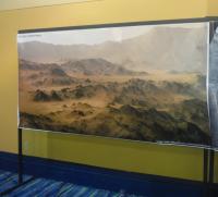
Posted by: Phil Stooke Mar 20 2018, 08:12 PM
Here is one of Sean's images on display at LPSC on Monday morning.
Phil
|
Posted by: Sean Mar 20 2018, 08:21 PM
Thanks for this Phil...do you mind if I share it on that thing called social media?
Posted by: Phil Stooke Mar 20 2018, 08:34 PM
Yes, use it any way you like!
Phil
Posted by: Sean Mar 28 2018, 09:49 PM
Some updates...
A new Jezero flyby made with CTX & MARCI
https://flic.kr/p/24oMQpu
https://youtu.be/mYVuY9IUKl0
Gale crater color study made with HRSC & MARCI...
https://flic.kr/p/25woiLd
https://flic.kr/p/22QwnBh
Lots of wrinkles to iron out of this workflow still...
Posted by: jccwrt Mar 30 2018, 11:56 PM
Now make a simulated landing video in Jezero crater 
Posted by: Sean Jun 16 2018, 08:32 AM
Gorgonum Chaos...made with synthetic rgb mapped to HiRISE rgb
https://flic.kr/p/288xKEy
https://flic.kr/p/28dqbog
40 megapixel...
https://flic.kr/p/JzFGkV
Details...
https://flic.kr/p/L6GtKf
https://flic.kr/p/26RZUpH
Flyby animation...
https://flic.kr/p/L5jx9E
https://www.youtube.com/watch?v=XZc6ictXuIo
Posted by: Adam Hurcewicz Jun 16 2018, 11:00 AM
Great job Sean! Thanx 
Posted by: Sean Jun 16 2018, 10:42 PM
Gorgonum Chaos 2...a lower flyby with synthetic color pass derived from HiRISE rgb, extended sky & horizon.
https://flic.kr/p/26UcULZ
https://youtu.be/ODoZTcpqcN0
Posted by: monty python Jun 17 2018, 08:37 AM
Just fantastic as always from you.
I used to look at these scenes and think - look what water has done. But because of Oppy I think - look at what fault control has done.
Long live Oppy!
Posted by: Sean Jun 25 2018, 04:01 PM
New pass on 3xDTM Domoni Crater...
https://flic.kr/p/279hhsT
http://www.gigapan.com/gigapans/209243
https://flic.kr/p/28vVZ2r
http://www.gigapan.com/gigapans/209241
HiRISE RGB mapped to synthetic color [ for the color version ] & lots of remixing & repairs in Photoshop
Posted by: Sean Jul 15 2018, 09:46 AM
Ceti Mensa
https://flic.kr/p/295y4Gf
HiRISE RGB mapped to synthetic color
http://www.youtube.com/watch?v=J0sQU7t1lk8
Posted by: wildespace Jul 15 2018, 10:50 AM
Great work, Sean, as always.
I'm happy to see my HiWish fulfulled, it being some impressive dark sand dunes in Melas Chasma.
|
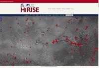
The proper https://www.uahirise.org/ESP_055322_1680 for it at HiRISE website will be up in August, but I did get the images at a preliminary stage:
Standard map projected images (RDR):
http://hirise-pds.lpl.arizona.edu/PDS/RDR/ESP/ORB_055300_055399/ESP_055322_1680/
Extras (RDR):
http://hirise-pds.lpl.arizona.edu/PDS/EXTRAS/RDR/ESP/ORB_055300_055399/ESP_055322_1680/
The two dunes are about 1 to 1.5 km wide and 5 to 6 km long.
These dunes are so large, they have dunes of their own:
|
Any ideas as to how such big dunes got there, in that part of Valles Marineris?
The IRB image looks so cool!

|
Oblique view from Google Earth:
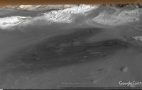
|
P.S. When we do get the stereo pair, could somebody please make a 3D model based on that and make a cool flyover video?
Posted by: monitorlizard Aug 5 2018, 07:03 PM
This is mostly on topic, does anyone know what science observations MRO is taking during the dust storm? Specifically, HiRISE imaging would seem to be a waste of precious downlink volume. Are other instruments being used more?
Posted by: Sean Aug 5 2018, 07:58 PM
Thanks. I'm not sure what criteria is used to determine which stereo pairs are converted to dtm's. I do know that only a small fraction of stereo pairs have been converted and that the computation required to do so is intensive.
Posted by: Explorer1 Aug 5 2018, 08:49 PM
https://www.jpl.nasa.gov/images/mer/20180613/Zurek-3-16.jpg
There seem to be some observations of wind movement with HiRISE, but the other instruments (CTX, CRISM, MCS, and Marci) are contributing to observations in other ways.
Posted by: Sean Aug 31 2018, 05:34 PM
Another portrait of one of the mounds in Ganges Chasma...
https://flic.kr/p/2ax2J7y
Posted by: Sean Sep 4 2018, 04:04 PM
Ganges Mensa
https://flic.kr/p/NCjfkb
4k version on https://youtu.be/oGGltr6emGw & https://vimeo.com/288191145
Posted by: Sean Sep 4 2018, 05:25 PM
Glacier
https://flic.kr/p/NCrhJf
4k version on https://youtu.be/obt9saX_i8U & https://vimeo.com/288209952
Glacier portrait
https://flic.kr/p/2aLau4Z
Posted by: Sean Sep 30 2018, 04:30 PM
Columbus
https://flic.kr/p/2atVx1N
4k version on https://youtu.be/RuJ6aaBNTJ8 & https://vimeo.com/292564916
https://www.uahirise.org/dtm/dtm.php?ID=PSP_005429_1510
Posted by: lyford Sep 30 2018, 05:56 PM
Sean, at this rate someone will need to rename the header "AMAZING IMAGES" from "interesting images!"
Posted by: hendric Oct 1 2018, 04:19 PM
Sean, with the discussion on Arsia Mons, is there DTM data? Could you do a flyby, esp. of the SW flank where the clouds seem to be starting? Thanks!
Posted by: djellison Oct 1 2018, 05:56 PM
Sadly there's no HiRISE DTM's of the area.
Some HRSC Images do though.... -
http://viewer.mars.asu.edu/planetview/inst/hrsc/H0263_0000_DT4#P=H0263_0000_DT4&T=2
There may be others according to HRSC View.
|
Posted by: Sean Oct 2 2018, 09:54 AM
It might be a while before I can look at that area, any decision to render will depend on data coverage/quality & aesthetic.
Zephyria region...
https://flic.kr/p/2afnxdz
4k on https://youtu.be/GRxoRfZBdBc
http://www.uahirise.org/dtm/dtm.php?ID=ESP_017825_1760
Posted by: Sean Oct 3 2018, 04:37 PM
A flyby of polygonal ridges in the Syrtis region.
https://flic.kr/p/2azLRVJ
4k on https://t.co/MCZaES6xk0 & https://vimeo.com/293160601
https://www.uahirise.org/dtm/dtm.php?ID=ESP_019133_1975
Posted by: nogal Oct 3 2018, 11:18 PM
Congratulations Seán! And many thanks for taking this topic.
I posted pointers to the video on the Zooniverse https://www.zooniverse.org/projects/mschwamb/planet-four-ridges/talk/668/753284 project's chat.
I expect volunteers to be ecstatic, as I am. It is so much nicer to see them with perspective!
Fernando
Posted by: nogal Oct 3 2018, 11:33 PM
While working on classifying subsets of CTX images on the https://www.zooniverse.org/projects/mschwamb/planet-four-terrains and https://www.zooniverse.org/projects/mschwamb/planet-four-ridges projects on Zooniverse, I often need to visualize the full CTX or search for nearby CTX or HiRISE images.
That used to be easy using the http://image%20explorer from ASU. Having loaded the reference CTX with the image explorer, I just clicked the "View this image in context on an interactive map" button. Sadly this capability seems to no longer be working for CTX and HiRISE images, despite still being available for THEMIS.
Does anyone know what happened or how to bypass an eventual problem? Thanks
Fernando
Update: the capability has been restored. Thanks are due to those making it happen!
Posted by: Sean Oct 6 2018, 10:47 AM
Thanks Fernando, here is Ius Chasma...
https://flic.kr/p/2anc9CH
4k on https://youtu.be/iG8BJHJsqIA
https://www.uahirise.org/dtm/dtm.php?ID=ESP_024954_1720
Posted by: nogal Nov 27 2018, 11:13 PM
It seems that the correction to MRO CTX Viewer problems I mentioned in Post http://www.unmannedspaceflight.com/index.php?showtopic=8179&view=findpost&p=241323 did not catch everything.
The "View this image in the context of an interactive map" button now works almost perfectly. It does open a map, but it is centered on the wrong coordinates.
For instance, for image F13_041029_0968_XN_83S057W the map opens centered on 83.3º N / 302.5º E. North when it should have been South.
The absolute value of the latitude is used to position the map.
It would seem the code is parsing the image ID but fails to take the N or S indication into consideration.
Perhaps some viewer of this forum knows someone able to fix it? Thanks.
Fernando
Posted by: RoverDriver Nov 28 2018, 01:02 AM
Perhaps this is related to the direction in which the HiRISE strip is captured? Some have North up and some South up. That information is present in the .LBL file. I don't think it is possible to determine it from the file name.
Paolo
Posted by: nogal Nov 28 2018, 10:14 PM
Thank you Paolo. I am aware of this "image flip", I believe it is not it. I really do not know what is causing it, but several of the PlanetFour:Terrains project's volunteers (myself included) are heavy users of the viewer. It is quite handy to view the CTX in context in order to find near ones and overlaps. The CTXs used by the project are from the south pole area, so we were surprised to be taken to the north polar area!
Fernando
Posted by: Sean Jan 16 2019, 02:15 PM
Testing some new rgb / synthetic rgb blends...
Medusa Fossae
https://flic.kr/p/23CUY2c
For the 3D texture I target HiRISE rgb and build out a synthetic rgb map then blend in Photoshop.
Posted by: Sean Jan 17 2019, 09:02 PM
Medusa Fossae Bullseye
https://flic.kr/p/2ecb9jd
rgb / synthetic rgb
https://youtu.be/lNn5QGM8fwU
Posted by: Paul Marshall Feb 5 2020, 08:17 PM
3D Flyby of the Grand Canyon on MT Sharp in false colour.
Best viewed on a 4K TV: https://youtu.be/9Ug5bvRRaEI
https://youtu.be/9Ug5bvRRaEI
HiRISE DTM used: https://www.uahirise.org/dtm/dtm.php?ID=PSP_006855_1750
Posted by: Sean May 31 2020, 06:17 PM
https://flic.kr/p/2j7voLf
Full 33 minute version in 4k on https://youtu.be/m_geeog42mk
Here is a link to the https://twitter.com/_TheSeaning/status/1267090543529603082
Posted by: Hungry4info Jun 2 2021, 02:07 AM
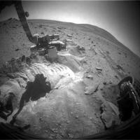
A new image of the Spirit rover, taken 25 Apr 2021.
https://www.uahirise.org/ESP_069122_1650
https://twitter.com/kevinmgill/status/1399769072917639175
|
Posted by: kenny Jun 6 2021, 07:31 PM
Fascinating... doesn't it look dusty?
Not the slightest glint of shiny metal.
Posted by: PDP8E Sep 2 2021, 10:33 PM
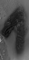
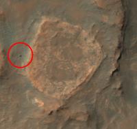
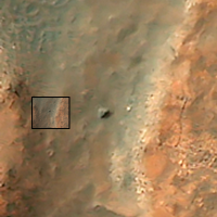
April 2021 MRO of MER-Spirit at 'Home Plate'
(finally got this image off the back-burner)
Spirit is stuck in Scamander / Troy -- the front of the Rover is roughly NW in the image
I think you can make out the 'churned up' area to the N/NW of the rover. Spirit was trying very hard to back out.
2021 MRO image inside the larger image
|
churned up area in front of the rover (from Spirit)
|
Powered by Invision Power Board (http://www.invisionboard.com)
© Invision Power Services (http://www.invisionpower.com)