Printable Version of Topic
Click here to view this topic in its original format
Unmanned Spaceflight.com _ MRO 2005 _ The power of HiRISE
Posted by: Stu Oct 9 2008, 08:04 PM
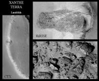
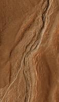
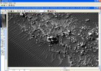
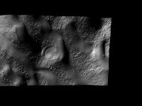
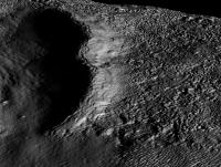
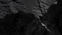
Busy preparing a new Outreach talk here, and have been trying to find some images to illustrate the "power" of HiRISE for a non-technical audience. Playing about with - sorry, carefully looking at the images on - the addictive http://global-data.mars.asu.edu site I found a cute landslide on Xanthe Terra that does the trick nicely. Using the IAS Viewer you can zoom in on the boulders carried down the slope by the landslide and even see cracks and splits in them... unbelievable...! 
|
Anyone else got any fave examples?
Posted by: stevesliva Oct 9 2008, 09:20 PM
Emily's series about White Rock is good, too. 
(Course now that I go looking, it might not have gotten to HiRise!)
http://www.planetary.org/blog/archive/35/
Posted by: elakdawalla Oct 9 2008, 09:35 PM
I did -- but you remind me I promised to wrap this up, and I haven't delivered on that promise yet...
http://www.planetary.org/blog/article/00001419/
--Emily
Posted by: Stu Oct 9 2008, 10:29 PM
Yep, Emily's "White Rock" sequence is an outstanding piece of work, to be sure. I'm not comparing this Xanthe sequence to it at all; I was just struck by the detail visible in those shattered rocks 
Posted by: mchan Oct 10 2008, 03:14 AM
As in Emily's presentation, consider adding scale bars to the images?
Posted by: Fran Ontanaya Oct 10 2008, 08:10 AM
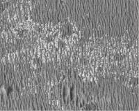
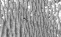
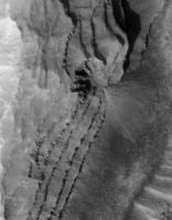
Spider:
http://hirise.lpl.arizona.edu/PSP_003087_0930
The famous avalanche:
http://hirise.lpl.arizona.edu/PSP_007338_2640
Rolling stones:
http://hirise.lpl.arizona.edu/images/2008/details/cut/PSP_007547_1895_cut.jpg
Frost covered gullies:
http://hirise.lpl.arizona.edu/PSP_001552_1410
Posted by: AndyG Oct 10 2008, 08:48 AM

http://hirise.lpl.arizona.edu/images/2008/details/cut/PSP_007547_1895_cut.jpg
I've not seen the image on the right before - I make that an Evel Knieval-like ~17m jump across the crater. Imagine being sat in the bottom of that as a 4m rock zips over your head...
Andy
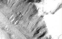
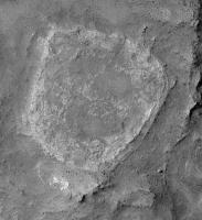
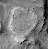
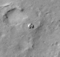
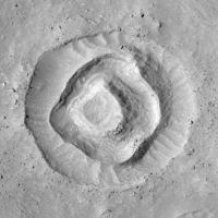
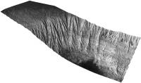
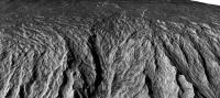
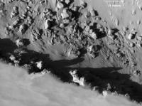
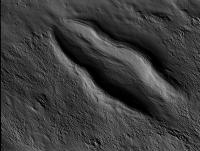
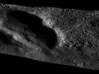
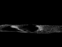
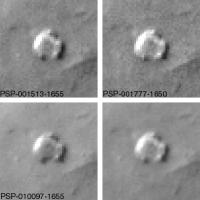
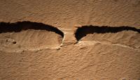
Posted by: peter59 Nov 28 2008, 09:08 PM
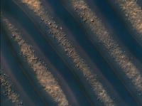
I found another unusual boulder track. You can see clearly how increased speed of the boulder on the slope. Jumps were increasingly longer, even a few dozen meters.
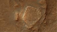
Hills Northeast of Mojave Crater (PSP_008430_1895) - general view
|
Hills Northeast of Mojave Crater (PSP_008430_1895) - "Rolling Stone"
|
Boulder in the final position
|
I was very skeptical before Mars Reconnaissance Orbiter mission. Another mission to Mars similar to the Mars Global Surveyor mission, what's interesting in this. I was wrong, MRO is the ultimate achievement in the field of imaging of Mars from orbit.
Posted by: charborob Nov 28 2008, 09:23 PM
Judging from the freshness of the tracks, this event must have happened quite recently. Did MRO by any chance image this area before?
Posted by: Nirgal Nov 28 2008, 11:18 PM
Yes, Absolutely. MRO almost "feels" more like viewing the martian landscape out of a helicopter window than from orbit ...
When I was younger I have always been dreaming about future Mars missions involving balloons or airplanes and wondered how phantastic a feeling it would be to view all the images and vistas those aircrafts would take from above ... finally bridging the gap in scale between the ground level images of the landers (Viking) and the very low resolution views of the orbiters ... Now we don't have martian airplanes yet but we have MRO ... and it's even better for it's global scope of operation
Posted by: ilbasso Nov 29 2008, 04:33 AM
I would love to see an anaglyph of that scene!
Posted by: OWW Nov 29 2008, 01:37 PM
Interesting thought. Is there a way to calculate at what altitude a human (eye) has the same resolution as HiRise? Is it comparable to a helicopter flight or looking down through the clouds from an airliner?
Posted by: RoverDriver Nov 29 2008, 03:21 PM
Assuming that the human eye visual acuity is about 0.59 arc min and HiRISE at 0.25m/pixel you get an altitude of about 1456m or about 4800' (if I did my math correctly).
Paolo
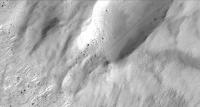
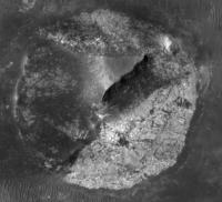
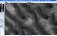
Posted by: Tman Nov 29 2008, 03:48 PM
|
|
What's circa the size of that boulder? 3x4 meters?
Posted by: hendric Dec 1 2008, 10:33 PM
There was some concern before that HiRise's resolution would actually be greater than the Mars atmosphere would allow due to twinkling. Has anyone taken a look at that again? What's the new maximum theoretical resolution from orbit? Less than 5cm?
Posted by: Nirgal Dec 1 2008, 10:49 PM
I don't know the exact numbers but from looking at many hundreds of HiRise image it does "feel" like the highest resolution level indeed lacks some of the "crispness" of the larger scale zoom levels ... don't know if this is due to atmosphere twinkling or other optical and/or image processing effects though ....
Posted by: Sunspot Dec 2 2008, 09:08 AM
The camera developed a fault not long after science operations began. There has been an obvious deterioration in image quality as a result - images are much grainier and not as crisp.
Look at this first picture obtained of Spirit at Home Plate
|
Posted by: SteveM Dec 2 2008, 02:44 PM
The reported degradation of the camera has been found to be minimum in past discussions; see, for example:
These two statements are 100% correct. Just thought I'd point that out.
and
"Alfred McEwen of the University of Arizona, Tucson, principal investigator for the camera, said, "I'm happy to report that there has been no detectable degradation over the past five months." "
"McEwen said, "Given the stability we've seen and understanding the nature of the problem, we now expect HiRISE to return high-quality data for years to come." "
yay!
Steve M
Posted by: Stu Dec 10 2008, 02:39 PM
Hey, look... HiRISE is on Twitter now, too...
http://twitter.com/HiRISE
Posted by: lyford Dec 10 2008, 04:18 PM
A picture is worth 140 characters!
Posted by: Stu Dec 11 2008, 08:46 PM
Just... beautiful... 
http://cumbriansky.wordpress.com/2008/12/11/the-glory-of-mars
Posted by: OWW Dec 11 2008, 09:01 PM
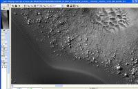
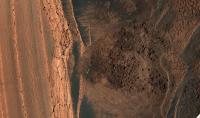
Many of the recent images are very noisy indeed. Others however, are still very good. This image of Gusev was taken just three months ago.
http://hirise.lpl.arizona.edu/PSP_010097_1655
|
Posted by: akuo Dec 11 2008, 10:20 PM
AFAIR the noise problem was present only in some of the CCDs in Hirise's CCD array. Also the problem was remedied somewhat by warming(?) the CCDs.
I think the atmospheric conditions on Mars play a bigger role. That could be seen in some of the images taken during the major dust storm around rovers' regions.
Posted by: Stu Dec 21 2008, 07:09 PM
Inbetween writing Christmas cards and eating mince pies today I've been playing about with the wonderfully addictive website http://global-data.mars.asu.edu that lets you explore Mars through the eyes of spaceprobes from Viking to MRO. I like just dipping in at random, playing a kind of "martian lucky dip" if you like, and seeing what turns up. I just found something interesting... well, I think it is.
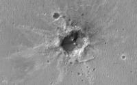
Image http://hirise.lpl.arizona.edu/PSP_005665_1800 is entitled "Change detection in Dark spot", so I thought it was worth a look... change is always a good thing on Mars, after all... into IAS Viewer and fine, looked just like one of those "fresh impact craters" to me - a dark "splash" of colour on a bright background. Zoom - and yep, right in the centre there's a small cluster of craters. But that's not what caught my eye - what made me go "hmmm" were the many dark lines and trails coming off the terrain around it. There are hundreds of them! I'm just puzzled what I'm seeing... this isn't a polar area, so the light terrain can't be frost- or snow-covered, yet it looks like something is coming out from underneath a surface layer..?
|
Anyway, just thought it was interesting - note: not odd, interesting! - and wondered if anyone has any thoughts about it.
HiRISE. What a fantastic camera!
Posted by: ElkGroveDan Dec 21 2008, 07:11 PM
Stu, do those lines appear throughout the region or just in the immediate proximity to the new craters?
Posted by: Stu Dec 21 2008, 07:16 PM
Best to take a look yourself Dan... they're more common close to the craters I think, but not exclusive to the immediate area.
Posted by: OWW Dec 21 2008, 09:27 PM
They look like ordinary dry dust avanches.
Posted by: imipak Dec 21 2008, 09:28 PM
Fascinating, good catch, I'm looking forward to finding out what on Mars it is... 
Edit: OWW - thanks!
Posted by: Stu Dec 21 2008, 09:37 PM
Exactly what I thought... wasn't suggesting anything else... just thought it was an interesting area and thought others might think so, too. Still a bit puzzled by the process tho... there are an awful lot of them, and they do look like they're coming from beneath a surface layer of some kind, to my eye at least. But I'm no geologist, obviously.
Posted by: OWW Dec 21 2008, 09:58 PM
Me neither.
But I don't see any layers. To me, it looks like they all begin at the top of the 'plateaus'.
Posted by: Stu Dec 21 2008, 10:15 PM
Hmmm, you may be right. I'm just very impressed with the area in general.
Posted by: OWW Dec 21 2008, 10:39 PM
Easily impressed huh? Dust, dust and... more dust.
To me this terrain looks much more diverse, interesting and....beautiful:
http://hirise.lpl.arizona.edu/PSP_009537_2045
Follow that riverbed at 50% zoom and be amazed.
And one weird crater:
http://hirise.lpl.arizona.edu/PSP_009320_2150
|
Posted by: Stu Dec 22 2008, 08:36 AM
Dust, dust and... more dust.I'm impressed by the thought of all that dust sliding down those slopes, yeah, cos I can imagine being there and seeing, what, dozens of avalanches of dark dust and stones hissing and slithering down the sides of the ridges or plateaus or whatever they are all around me, triggered by - what? Gentle rumblings in the rocks beneath the mighty volcanos that lie to the east? A tremor running through ground after a faraway impact?
Sometimes it's what you can't see that makes a martian landscape magical.
Love your weirdy crater tho - present for you
http://img.photobucket.com/albums/v509/cumbriansky/OWWcrater2.jpg
Posted by: OWW Dec 22 2008, 11:44 AM
Then you're gonna Love this one:

http://hirise.lpl.arizona.edu/PSP_004390_1035
Here's another strange crater.... I THINK it was a crater once.
http://hirise.lpl.arizona.edu/PSP_010206_1975
|
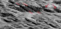
Posted by: sariondil Dec 22 2008, 03:22 PM
But I don't see any layers. To me, it looks like they all begin at the top of the 'plateaus'.
There are some coarse layers (red lines in the attached image) in the underlying material (Medusae Fossae Formation according to the Geologic Map of the Western Equatorial Region) and some hints of fine-scale layering (see arrows). But these layers are apparently not the sources for the dust. It could be created by surficial weathering of the layered rocks, consistent with the observed sources near the top of slopes.
|
Posted by: mchan Dec 24 2008, 03:03 AM
The Face that was Erased. Hoaxland will have a field day.
Posted by: Stu Jan 5 2009, 02:27 PM
Couple of new shots here...
http://cumbriansky.wordpress.com/2009/01/05/more-hirise-highlights
Posted by: centsworth_II Jan 5 2009, 05:04 PM
shots here...Dancing with the stars!
|
Posted by: Nirgal Jan 5 2009, 05:16 PM
full inline quote removed - mod
Wow: the perfect shot
(and the perfect title, centworth II
Posted by: tuvas Jan 25 2009, 05:12 PM
I think the atmospheric conditions on Mars play a bigger role. That could be seen in some of the images taken during the major dust storm around rovers' regions.
The noise in HiRISE images was almost completely eliminated by warming up the CCDs prior to use, the only exception was that IR 10-1 is still a bit noisy, which was the worst of the CCDs. I think they might have even gotten rid of that one too, but it's been a while since I've checked...
Posted by: Stu Apr 23 2009, 07:19 PM
HiRISE zooms in on Pavonis...
http://cumbriansky.wordpress.com/2009/04/23/hirise-zooms-in-on-pavonis
Posted by: Stu Apr 25 2009, 08:04 AM
... and another "volcanic treat" from HiRISE...
http://cumbriansky.wordpress.com/2009/04/25/another-hirise-volcanic-treat
Love that camera!
Posted by: ngunn May 7 2009, 11:47 AM
Stu, I hope you don't mind me posting this link here (since you haven't yet). I found it fascinating. Your impact sites seem to be arranged in a nice 'landing ellipse'! Several questions come to mind. Is the group statistically significant in terms of spatial and temporal density such that a common origin is a serious possibility? Is the 'landing ellipse' consistent with an atmospheric break-up, or is it too big? Folks here can shed light I'm sure.
http://cumbriansky.wordpress.com/2009/05/06/incoming-tharsis-not-a-good-place-for-a-mars-base/
Posted by: nprev May 7 2009, 12:05 PM
Shooting from the hip here, Stu's impact cluster (great find & great article, BTW, dude! ) covers a very large amount of surface area, so I wouldn't expect them to originate from the atmospheric breakup of a single object. Mars' atmosphere is super-thin anyhow, and nowhere is it thinner than in the Tharsis Bulge area.
However, one interesting possibility is that this is what's left of the impact of five or more discrete objects that were once one, but were disrupted while still in space into a loose association separated by tens of km or more. Perhaps a small comet nucleus that had been fragmented after perihelion passage then had the misfortune to encounter Mars on the outbound leg?
</wild speculation mode>
Posted by: Stu May 7 2009, 02:08 PM
Thanks guys, glad you found the post interesting. It's probably just a coincidence that those "fresh craters" are all in the same area (roughly), but hey, you never know. I just thought it was an interesting find. Man, I love HiRISE!
Posted by: Stu Aug 12 2009, 04:02 PM
Very very very cool pic of Victoria Crater released today... oblique view...
http://hirise.lpl.arizona.edu/ESP_013954_1780
Oppy's tracks stand out really clearly on it, too...
|
Posted by: Phil Stooke Aug 12 2009, 06:49 PM
Nice! And here's the intrepid rover itself.
Phil
|
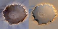
Posted by: Astro0 Aug 14 2009, 06:55 AM
A comparison between the two HiRise images of Victoria Crater.
I've taken the original view and have oriented and distorted it to a similar perspective as the latest version.
|
Posted by: Stu Sep 2 2009, 11:45 PM
Colourised crops from image of gullies in Gale Crater, released today...
|
|
Posted by: ElkGroveDan Sep 3 2009, 12:08 AM
The absence of any impact features at any scale here is just amazing.
Posted by: elakdawalla Sep 3 2009, 01:52 AM
Wow...well spotted, Stu.
The quantity of space imagery being released these days that I don't have time to look through is both marvelous and depressing 
--Emily
Posted by: nprev Sep 3 2009, 02:09 AM
Remarkable; thanks, Stu!!!
Correct me if I'm wrong, but is that an island in the middle of the channel? Hmmm exp hmmmm....
Posted by: djellison Sep 3 2009, 11:45 AM
Gale still gets my uneducated MSL vote. It's just more spectacular than the others.
Posted by: mhoward Sep 3 2009, 03:11 PM
I could explain the lack of impact features to myself, since this is a small area presumably on a crater wall. But an island seems really interesting.
Is this actually Gale, or is it Hale? I saw a gullies in Hale image posted, didn't see Gale yet.
Posted by: djellison Sep 3 2009, 03:36 PM
Stu said those a few posts ago were Gale.
Posted by: ElkGroveDan Sep 3 2009, 04:10 PM
I agree. I'm particularly concerned about Ebrswalde which I fear looks enticing on a macro scale but like Gusev it could become a disappointment (the serendipitous Columbia Hills notwithstanding), possibly hard sandstone maybe even overlaid with some kind of cap-rock obstruction. I like Gale but I also think the likely breathtaking scenery at Holden would be something to keep Stu's inkwell stirred.
Posted by: Stu Sep 19 2009, 11:09 AM
"Baby" gully on a new HiRISE image..?
http://cumbriansky.wordpress.com/2009/09/19/gorgeous-gullies-2
Just wondering... all input appreciated
Posted by: Hungry4info Sep 19 2009, 12:48 PM
I'm certainly no geologist, but I agree with your interpretation of that. Definitely would be nice to get a second image of it later.
Posted by: dvandorn Sep 19 2009, 05:22 PM
If it's a "baby" gully, it's been a baby for quite a while. The sand ripples evident in the image seem to have conformed to the dip into the linear depression. If this feature were a new gully that is just beginning to form, you wouldn't expect that there would have been time for such conformal ripples to have formed along the topography.
-the other Doug
Posted by: Stu Sep 19 2009, 11:04 PM
Ah, good thinking Doug, thanks. All input appreciated; it was just something that caught my eye.
Posted by: ElkGroveDan Sep 19 2009, 11:51 PM
I would add however Stu that the age of dunes on this steep slope doesn't necessarily correspond to the age of dunes on the plains of Meridiani. So don't abandon your idea yet. For all we know these dunes migrate down that slope on a much more frequent basis. And if the composition is different from what we've seen previously then the mechanical properties of the particles comprising them will be different too. Show me this same photo two years hence and then we can come to some conclusions.
Posted by: climber Sep 24 2009, 04:49 PM
A teleconference scheduled shortly (today): http://www.spaceref.com/news/viewpr.html?pid=29221
Posted by: Julius Sep 24 2009, 07:00 PM
teleconference was about water on the moon! Solar wind trapped in lunar soil:hydrogen ions combining with oxygen in the soil to form hydroxyl and water molecules...higher concentration at the higher latitudes towards the poles...diurnal variations with higher concentrations in the morning and dusk!
Posted by: djellison Sep 24 2009, 07:25 PM
That was the lunar press conference.
Right NOW - there is a teleconference about MRO -
http://www.nasa.gov/news/media/newsaudio/index.html
http://www.nasa.gov/mission_pages/MRO/news/mro20090924.html
They have spotted ice in fresh craters. Not 1% ice in Moon soil. 99% ice in mars soil
Would you like some ice with your lunar regolith? How about some martian regolith with your ice.
Posted by: Greg Hullender Sep 24 2009, 08:26 PM
As with Dr. Johnson's dancing dog, the wonder is not that there's great ice on the moon -- the wonder is that it's there at all.
However, I'll admit Martian ice in fresh craters is pretty cool too.
--Greg
Posted by: Stu Sep 30 2009, 11:08 PM
Colourised crop from one of today's HiRISE releases...
http://twitpic.com/jrojd/full
Posted by: nprev Sep 30 2009, 11:45 PM
THAT is an incredible image, Stu; thank you!!!
Posted by: Holder of the Two Leashes Oct 1 2009, 03:00 AM
I think I saw one of those carved into a cliff at Chaco NHP.
Posted by: DFinfrock Oct 1 2009, 05:13 AM
Chaco is one of my favorite parks. I was there once during a total lunar eclipse. It was magical.
David
Posted by: JohnVV Oct 1 2009, 06:55 AM
Nice photo .It almost looks like we have some "crop circle Artists " up there
Posted by: Stu Oct 1 2009, 11:55 AM
The latest batch of releases also features a rather http://hirise.lpl.arizona.edu/ESP_014413_0930 of some of the "martian spiders" - sorry, "radial channels" ... couple of colourised crops here...
http://twitpic.com/jtjdy/full
http://twitpic.com/jtjf8/full
Posted by: Stu Oct 9 2009, 05:39 AM
Just a gorgeous, gorgeous view...
http://twitpic.com/krklr
Posted by: Nirgal Oct 10 2009, 11:19 PM
Wow: great find Stu ! ... one of the most phantastic, surrealistic martian dune formations yet
Posted by: Tman Oct 11 2009, 03:05 PM
Subtiler, but DDs can do beautiful artwork too. It's fascinating to see how the DDs spun around.
Cropped and sharpened image:
2.7MB full res. http://www.greuti.ch/mro/ESP_014426_2070.jpg
0.65MB http://www.greuti.ch/mro/ESP_014426_2070s.jpg
Posted by: stevesliva Oct 11 2009, 03:34 PM
I love the combination of slope streaks and dustdevil tracks! It's a smoking gun of sorts.
Posted by: sgendreau Oct 11 2009, 04:05 PM
http://twitpic.com/jrojd/full
Any geological types want to hazard a guess what this is? Crater with multiple rims, maybe? (I'm not good at whether a feature is an innie or an outie.)
Posted by: centsworth_II Oct 11 2009, 06:15 PM
The smoking gun of coincidence!
Posted by: volcanopele Oct 11 2009, 06:19 PM
hmm, looks like craters that's been eroded down to their "cores". The boulders could be megabrecia.
alternatively, could be eroded, heavily jointed basalt... In which case you are looking at the tops of plutonic dikes.
Either way, lots of erosion.
Posted by: stevesliva Oct 11 2009, 09:28 PM
Not so much. I meant the DD tracks are second very visual indication that a lot of dust moves around in the atmosphere, and dust avalanches can occur when things get past the angle of repose.
Posted by: climber Oct 15 2009, 08:27 PM
What about this one?

|
Posted by: ElkGroveDan Oct 15 2009, 08:38 PM
That is amazing. It looks like a blanket with an artistic pattern.
Posted by: Phil Stooke Oct 15 2009, 09:23 PM
This is where we need the guy who says 'Zis is not nuts, zis is super-nuts!'
Phil
Posted by: Greg Hullender Oct 15 2009, 10:34 PM
My gosh! At first I thought it was a joke picture of someone's tattoo. Where/what is it?
--Greg
Posted by: Phil Stooke Oct 15 2009, 10:38 PM
Not a bad idea... I think I will get that tattooed on me.
Phil
Posted by: infocat13 Oct 16 2009, 12:31 AM
are the dunes in valleys?
are the surrounding terrain hills?
and mars has a thin atmosphere
do the wind cyclones die as they leave the valley and terminate at the tops of the hills?
of course the counter argument is on earth the valleys would be cold at there floors this must not be the mechanism on mars for energy for a cyclone or tornado.
tornadoes on mars must be driven differently then on earth
Posted by: Astro0 Oct 16 2009, 12:42 AM
Where/what is it?
Check it out http://hirise.lpl.arizona.edu/ESP_014426_2070.
Posted by: nprev Oct 16 2009, 12:57 AM
This one just gets more fascinating every time I look at it; definitely one of HiRISE's Top 10 most beautiful & intriguing images!
Posted by: Stu Oct 16 2009, 11:38 PM
(Looking at LROC image...)
Call that a bouncing boulder? THIS is a bouncing boulder..!
http://twitpic.com/lsry0
http://twitpic.com/lss3l
(from HiRISE image ESP_01439_2045)
Posted by: nprev Oct 17 2009, 02:16 AM
...holy [clinking] [clink!!!!] Can't believe what I'm looking at here, Stu, what a find!
Posted by: elakdawalla Oct 17 2009, 03:59 AM
Stu, that's not resolving; can you check your source? I think there should be six digits in the first cluster of numbers.
Posted by: ElkGroveDan Oct 17 2009, 04:42 AM
Emily try http://hirise.lpl.arizona.edu/ESP_014394_2045 .
Posted by: elakdawalla Oct 17 2009, 05:18 AM
Thanks Dan!
Posted by: Stu Oct 17 2009, 05:39 AM
...holy [clinking] [clink!!!!] Can't believe what I'm looking at here, Stu, what a find!It's not a "find"; the image is already labelled "bouncing boulder" on the HiRISE site. I just coloured it in a bit :-)
Posted by: nprev Oct 17 2009, 05:54 AM
Aah, you still deserve the props, big guy. It's an important image for understanding the behavior of these things; thanks for bringing it to life!
Posted by: Pavel Oct 17 2009, 06:04 AM
How could a dust avalanche flow around the boulder so neatly?
Posted by: Stu Oct 17 2009, 06:37 AM
If you liked that, Nick, you'll love this...
http://twitpic.com/lug9n
Posted by: nprev Oct 17 2009, 06:47 AM
HA!!!  Christmas in October! What a stunning sight; thanks, Stu!
Posted by: stevesliva Oct 17 2009, 01:12 PM
Has this been mentioned here before? I'm not sure how old it is!
http://hirise.lpl.arizona.edu/earthmoon.php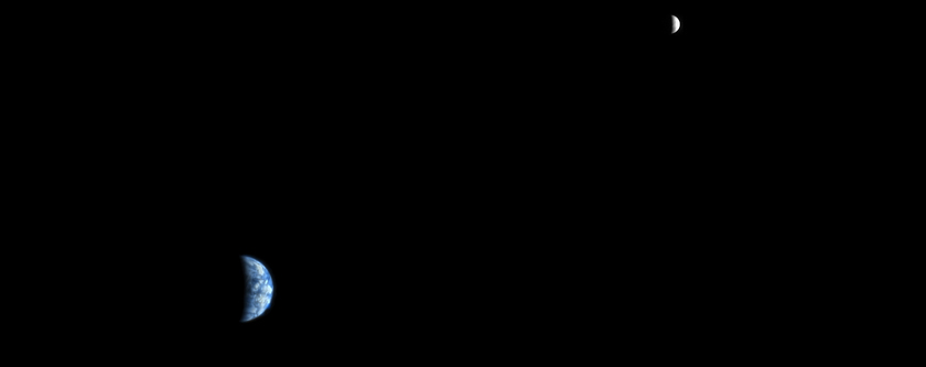
Posted by: Tesheiner Oct 17 2009, 02:08 PM
It's stated on that very same page: "... acquired at 5:20 a.m. MST on 3 October 2007"
Posted by: stevesliva Oct 18 2009, 03:46 PM
Clearly I should have started a new topic for it, then.
Posted by: djellison Oct 18 2009, 05:51 PM
It's two years old - and for some reason Spaceref decided to feature it a few days ago without explaining why. Quite odd.
Posted by: imipak Oct 19 2009, 11:08 PM
http://twitter.com/HiRISE/status/4995880269 :
"Bouncing Boulder Blocks a Slope Streak http://tinyurl.com/ykp5q92 One of our fans pointed out how cool this image is!"
Posted by: Stu Nov 19 2009, 08:41 AM
Some colourised crops of the amazing layers visible in the new MRO image of Arabia Terra ( http://hirise.lpl.arizona.edu/ESP_014033_1910 )
http://twitpic.com/q31tf/full
http://twitpic.com/q31ul/full
http://twitpic.com/q31wk/full
Posted by: brellis Nov 19 2009, 01:18 PM
thx for those crops Stu. Looks like some dried up terraced hillsides. Those Martians must have really been into gardening!
Posted by: PDP8E Nov 19 2009, 02:57 PM
Stu,
Your work rocks!
(next time I am in England, I need to stop by for a tutorial from the color master! What is your hourly rate?)
Cheers
Posted by: climber Nov 19 2009, 07:18 PM
Also some view of Arabia Terra plus more on this "must see" video, whether or not you'll like the music associated (I did): http://nasawatch.com/archives/2009/11/todays-video-hi.html
Posted by: Stu Nov 29 2009, 08:59 AM
Magnificent dunes, with extra added gully goodness!
http://twitpic.com/rfom1/full
( from http://hirise.lpl.arizona.edu/PSP_001558_1325 )
Posted by: pgrindrod Dec 12 2009, 09:52 PM
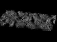
In the spirit of HiRISE releasing some DTMs, I thought I'd put up a couple of shots of my recent attempts at making some of these monsters.
I made it using exactly the same method (hopefully!) as the USGS, so switching between ISIS and SocetSet. It was one of the first I made, so it's got some striping in the overlaid orthoimage, but not in the underlying DTM. The recent hiequal command in ISIS has got rid of that striping now, but I don't have images of that attempt with me at the moment.
Whole DTM:
|
Close-up:
|
I thought I'd put them up here seeing as there's some chat over in the img2png thread. I've got to say that even though I use them everyday in my job, I still have to pick my jaw off the floor on a regular basis - awesome camera!
Pete
ps Doug - think you could work some of your movie magic with this?
Posted by: machi Dec 12 2009, 11:24 PM
Wow, magnificent view (especially second image)!
I always regret, that processing of raw HiRISE images are beyond capabilities of my current computer and internet connection.
Posted by: elakdawalla Dec 12 2009, 11:58 PM
That's OK. As you know, there are plenty of wonderful views to discover in older data sets that are not so difficult for your computer!
Posted by: machi Dec 13 2009, 01:27 AM
Yes!
So much to do and so little time.
Thanks for NASA, ESA, JAXA, IKI (and others) and their archives!
Posted by: Nirgal Dec 13 2009, 09:34 PM
Great work, pgrindrod !
the possibilities with those ultra-large, ultra-high precision data sets given to us by HiRISE are endless ...
It will take years and decades to fully realize the potential buried within this ocean of data
How true ...
Posted by: OWW Dec 25 2009, 11:31 PM
Interesting. Part of this layer seems to have collapsed. Impact crater or gravity?
http://hirise.lpl.arizona.edu/ESP_014033_1910
|
Posted by: stevesliva Dec 26 2009, 12:12 AM
Almost looks like an impact into really friable sandstone, and then gravity took over.
Posted by: charborob Dec 28 2009, 01:38 AM
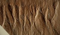
Here's an interesting image of some Mars spires. Judging from the length of the long shadow near the center of the image, the spire casting that shadow must be between 30m high (assuming a sun elevation of 30 degrees) and 50m high (assuming the sun at 45 degree elevation). Must be quite a sight from ground level.
(Unfortunately, I did not take note of the image number, and now I can't find it anymore. I just took a screen grab. I think it was somewhere on the flank of one of the Martian volcanoes.)
|
Posted by: charborob Dec 28 2009, 04:21 AM
Just from an aesthetic point of view, I find this image exceedingly beautiful:
(HiRISE Image PSP_010221_1420)
|
When I start browsing HiRise images, I could keep on for hours.
Posted by: Stu Jan 9 2010, 12:44 AM
Colourised view of gullies...
|
Posted by: djellison Jan 9 2010, 03:48 AM
For those wondering, at some point, yes, I will be doing this
Posted by: Astro0 Jan 16 2010, 06:32 AM
ADMIN OOPS!
Accidentally lost this message when it was moved to this thread.
Sorry Den.
Den posted (along the lines of):
Amazing image from Hellas.
http://hirise.lpl.arizona.edu/ESP_016022_1420
Was it a lake at one time?
Posted by: Stu Jan 16 2010, 08:58 PM
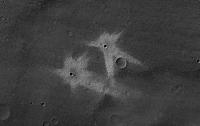
Wow... a natural "cairn" on Mars...
(cropped from ESP_016036_1370)
|
Posted by: sgendreau Jan 16 2010, 10:50 PM
What you mean "natural?" It's OBVIOUSLY an artifact.
Posted by: climber Jan 18 2010, 10:49 PM
More and more ammazing beauty
|
Posted by: nprev Jan 18 2010, 10:57 PM
...okay, THAT is flat-out cool as hell!!! How did you define your colorization scheme? That middle stripe of orange in each of the dune valleys is quite striking!
Posted by: helvick Jan 18 2010, 11:58 PM
Aren't they the dune peaks? If they aren't then something truly odd is going on with all those boulders on the tops of the dunes...
Posted by: nprev Jan 19 2010, 12:05 AM
Yeah, you must be right. It's hard (for me, anyhow) to gauge perspective in this image.
Posted by: Floyd Jan 19 2010, 12:11 AM
My guess--Orange stripes are dune peaks, rocks at valley bottom--like dunes on bedrock around Opportunity.
Posted by: Ames Jan 19 2010, 09:39 AM
No the dunes are very dark and the bedrock is light and strewn with boulders. Really plays games with your shadow perception.
Posted by: Stu Jan 19 2010, 10:02 AM
It actually helps - as is often the case with HiRISE images, I think - if you look at the black and white version first. Then it is clear that the boulders are "filling in the gaps" between the dunes...
|
(very cool dust ripple filled crater between the dunes there, don't you think?)
The bright "stripe" along the top of the dunes appears to be the dunes' actual peak..?
|
Posted by: climber Jan 19 2010, 11:51 AM
Very easy: copy-paste from a link @jpl
Posted by: tharrison Jan 19 2010, 01:36 PM
The orange stripe in the color image is actually in the slope of the dune face. It's probably just a different grain size than the surrounding material, as that's typically what HiRISE colors indicate. The dune crest is the smooth-looking dark portion in the grayscale image.
Posted by: Nirgal Jan 19 2010, 06:06 PM
here is a quick try at a single-image-SFS-DEM from the JPG above:
|
|
|
Note that in this case the algorithm in its current implementation does have troubles with the extreme albedo differences between the blackish dunes and the light colored rock (i.e variations in brightness that are not caused by illumination only) which causes distortions in the low frequency variations ...
Nevertheless the visual impression turned out quite interesting so I decided to post it anyway (and the vista does give a general idea on how this scene might look like when seen from the ground )
Posted by: OWW Jan 27 2010, 01:02 AM
In the CTX image http://viewer.mars.asu.edu/planetview/inst/ctx/P21_009058_1349_XI_45S255W
I saw this strange feature. What is this?
|
Posted by: nprev Jan 27 2010, 01:15 AM
Freaky-looking thing. The whole area looks like either an outflow plain or perhaps even a dust-covered glacier. Perhaps an oblique crater pair that was subsequently overrun by an ice or water flow?
Posted by: Juramike Jan 27 2010, 01:18 AM
I'd go with a deposit leftover from some sorta glacier-thingy. Almsost seems like there is a trail behind it. There's a lot of areas nearby that look like they slumped out.
Posted by: elakdawalla Jan 27 2010, 03:01 AM
Nice catch; that is truly weird. Based on other nearby features I'd say it was the remains of a multiple crater rim but it looks truly odd. Note the image is not HiRISE but CTX! I checked HiWish and there is no HiRISE image over the feature. I won't preempt your find; you should go to HiWISH and ask for a higher resolution view!
Posted by: sariondil Jan 27 2010, 09:53 AM
I don´t think this is part of a crater wall. Note how flat-topped and steep-sided it is, quite unlike the variously degraded craters around this feature. My bet is that these are http://en.wikipedia.org/wiki/Esker
There seems to be a lot of ice-related geology in this area. Those lobes coming down from the mountain in the center of the scene look like ice sheets with crevasses and flow lines.
Posted by: OWW Jan 27 2010, 10:57 AM
You're right. Forgot to mention that. There is no "The power of CTX" thread yet...
You can go right ahead if you (Hi)wish.
But I don't think a higher resolution image would help in this case. The http://hirise.lpl.arizona.edu/HiBlog/2010/01/22/more-hiwish-questions-answered/ warns:First, make sure you justify the image in terms of small-scale features that might be seen, things like boulders or thin layers or dunes, not giant volcanoes or channels. We need to know how HiRISEs meter-scale resolution is necessary, especially if there are existing MOC, CTX, HSRC or other images of the area.
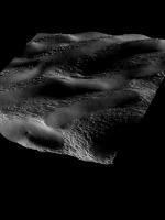
Posted by: Nirgal Jan 28 2010, 12:35 AM
I saw this strange feature. What is this?
Interesting. let's see how this thing might look like from the ground
here is my attempt at rendering a few 3D views of the formation, obtained from the single-image SFS DEM algorithm (described in more detail in the other thread)
|
|
|
|
|
|
Posted by: OWW Feb 1 2010, 07:56 PM
Nice work Nirgal. Looks very flat. Judging by the shadows I thought it had more relief.
Slightly different topic: Has anyone else had trouble with the HiRise site last couple of days? The Layout is all messed-up in my browser. I can't see the links to the IAS-viewer images anymore.
Posted by: OWW Feb 2 2010, 09:58 PM
This is very strange. I can see those links again in Firefox, but in IE8 they are still broken. Does anybody know what could be causing this?
Posted by: Tman Mar 24 2010, 09:30 PM
The "Crater garden" west of Victoria from ESP_016644_1780 (24 March):

|
Boomboomboom...! Who counts the number of impacts?
p.s. I added a bit sharpness
Posted by: SFJCody Mar 24 2010, 09:43 PM
Fresh looking crater (crater-pair?) about 9.5km south of Oppy's present position (also from ESP_016644_1780).
|
Posted by: Stu Mar 24 2010, 10:42 PM
Oppy's Lewis and Clark trek across the great martian desert of Meridiani...
|
Posted by: Explorer1 Mar 25 2010, 01:27 AM
What part of the route is this? Everything's beginning to blur together for me, it's been so long and so far...
Posted by: Poolio Mar 25 2010, 02:19 AM
Beginning of the westward route. Those are Nereus and Nautilus at the top of the image.
Posted by: Explorer1 Mar 25 2010, 05:09 AM
Thanks.
That was so long ago, it's hard to believe so much time has passed since we left Victoria, but it has.
Posted by: Stu Mar 25 2010, 10:53 PM
A crop from http://hirise.lpl.arizona.edu/PSP_002419_1675
|
Ansell Adams on Mars...
Posted by: JohnVV Mar 26 2010, 06:20 AM
how about this from the same hirise image
[attachment=21202:crop.png]
or
[attachment=21203:crop1.png]
Posted by: Stu Mar 27 2010, 05:13 PM
New astropoem, dedicated to all the people on the MRO and HiRISE teams..
http://twitpic.com/1bb60q
( text only version: http://astropoetry.wordpress.com/2010/03/27/ansel-adams-on-mars )
Posted by: Stu Apr 7 2010, 10:50 PM
Today's batch of new releases includes an image of Spirit's landing site, taken Feb 15th, on which Spirit herself can clearly be seen. Here's a colourised crop...
|
Posted by: Stu Apr 7 2010, 11:09 PM
... and a new, rather gorgeous avalanche shot...

|
(cropped and colourised from ESP_016423_2640 )
Posted by: nprev Apr 8 2010, 12:18 AM
Those are both exceptional images, Stu, thanks! Spirit's 'wings' are clearly resolved, amazing!
Posted by: ElkGroveDan Apr 8 2010, 03:30 AM
Looking like a frozen house fly stuck to a frosty window.
Posted by: Explorer1 Apr 8 2010, 04:01 AM
So this is what, the 3rd avalanche caught in the act? Are we sure MRO has no motion-sensor onboard? It sure seems that way!
Posted by: nprev Apr 8 2010, 04:15 AM
The fact that MRO doesn't have any motion detection capability is testimony to the (apparently) astonishingly high rate of occurrence of these events.
Really interesting stuff happening here. Is the Cap being replenished anywhere near as rapidly as its edges are eroding?
Posted by: centsworth_II Apr 8 2010, 06:05 AM
http://www.unmannedspaceflight.com/index.php?s=&showtopic=4268&view=findpost&p=156984a few weeks ago, it was revealed that there are avalanches in almost every MRO image during the 'avalanche season', and five avalanches from one image were shown.
Posted by: Tom Gwilym Apr 8 2010, 07:27 AM
Quote removed - Mod
Just about to go to bed, then I come across these new images. Can't sleep!
Very cool!
Posted by: OWW Apr 9 2010, 12:30 PM
Crater near graben in Syria Mons: http://hirise.lpl.arizona.edu/ESP_016529_1350
Was the smooth stuff deposited before or after the ripples formed?

|
Posted by: OWW Apr 9 2010, 01:18 PM
square crater(?). http://hirise.lpl.arizona.edu/ESP_016537_1425

|
Posted by: sariondil Apr 9 2010, 02:56 PM
Probably not a square crater, but an outcrop of folded stratified rock. There are several more U-shaped outcrops in the vicinity of this one.
Posted by: Stu Apr 10 2010, 07:13 AM
"Baby" avalanche spotted on an image ( ESP_016449_2650 ) in the latest big image release...

|
Posted by: schaffman Apr 11 2010, 01:21 PM
Was the smooth stuff deposited before or after the ripples formed?
Looks like the smooth stuff formed after the ripples. The smooth stuff resembles the material in the middle of the graben. (Note the presence of subdued craters in both units). This suggests that the smooth unit once covered a more extensive area and has been eroded away, exhuming an ancient rippled lanscape. This would mean that the ripples formed long ago and are most likely inactive today. Any other interpretations?
Tom
Posted by: Explorer1 May 11 2010, 01:30 AM
Oh wow!
http://www.universetoday.com/2010/05/10/latest-mars-avalanche-likely-triggered-by-impact-event/
Impact event thought to have caused an avalanche! Amazing picture, as usual!
Posted by: nprev May 11 2010, 02:14 PM
Interesting, but I dunno if I buy it. Why isn't there the usual dark ejecta apron around the postulated recent crater? Also, there's something not quite right about the diffuse upper boundary of the streak; that also seems atypical.
Posted by: Tesheiner May 11 2010, 02:56 PM
Because it was covered by the dust from the avalanche? My 2c.
Posted by: ElkGroveDan May 11 2010, 04:32 PM
I agree with Eduardo. Nick you of all people should know about avalanches. If you are unlucky enough to trigger one, the material both above and below you moves down the hill. Moreover, in this case it was more like those mortar shells that the ski patrol use to clear slopes. The airburst triggers the movement milliseconds before the object's impact over a broader area, both up and down the slope (and left and right). And from these images, that's what it looks like to me.
Posted by: climber May 11 2010, 07:44 PM
I'll be interested to know how steep is the place. May be you know that on Earth, natural (snow) avalanches start at 30° and they may be are the most dangerous (since one wouldn't believe they can start with such a low angle).
Posted by: schaffman May 12 2010, 11:56 AM
The dust avalanche is now featured at the HiRISE website:
http://hirise.lpl.arizona.edu/ESP_017229_2110
The location is in the Olympus Mons aureole (Lycus Sulci) not the slopes of the volcano as the earlier article indicated. This is an area of rough, highly jumbled terrain thought to be formed from huge gravity-slide deposits shed from the lower slopes of Olympus Mons. This region is extremelt dusty and dust streaks are ubiqutous.
I couldn't determine the slope of the hillside on which the avalanche occured from MOLA elevation data. The area in the portion of the CTX image shown in the article is very small (only about 2 X 2 km) and below the useful resolution of the gridded MOLA dataset from the JMars program. Maybe someone knows a more sophisticated way to determine the slope. In any case I would guess that 30 degrees or more of slope is certainly possible.
Tom
Posted by: Stu May 16 2010, 07:01 AM
Anyone else having trouble opening up images with the IAS Viewer?
Posted by: JohnVV May 16 2010, 07:20 AM
never used it till now.
it is crashing on Arch Linux Firefox 3.6.3
Posted by: Stu May 16 2010, 07:33 AM
Thanks, John. Anyone else?
Posted by: nomisn May 16 2010, 08:15 AM
Hi Stu
Just tried opening a HIRISE photo using IAS viewer from the HIRISE website and it didn't open ( I selected JP2 quicklook
IAS viewer) and got the following messages " Error in JPEG2000 Client unable to resolve host address "hijpip.lpl.arizona.edu"
and "unable to init IAS_TCPclient for server/port:hijpip.lpl.arizona.edu/8064"
Obviously something is up with IAS or the Hirise site at present
Posted by: Tman May 16 2010, 08:24 AM
Yes, (here) it stops when the main window has opened and it has displayed sporadically a "Asynchronous Warning".
Posted by: Stu May 16 2010, 08:25 AM
Thanks everyone who responded, appreciate it. So does my PC; it was *this* close to being hurled out the window...
Posted by: tharrison Jun 8 2010, 05:27 AM
The dark areas seen around most new martian impact craters are not ejecta features, but rather blast zones. The impacts basically blow away the dust on the surrounding surface, making it appear dark compared to the adjacent dust-mantled surfaces.
Posted by: climber Jul 16 2010, 02:32 PM
More beauties here: http://www.spaceflightnow.com/news/n1007/15hirise/
Posted by: Phil Stooke Jul 29 2010, 02:21 PM
Somewhere recently we were discussing the possibility of using super-resolution with scanning cameras, specifically HiRISE. I did an experiment using pictures of the old Spirit lander. I tried finding images of other places at Meridiani - Beagle crater, Eagle crater... but the difficulty was finding multiple high quality images of the same location with comparable lighting and atmospheric conditions. Despite what you might think there are not many places where the coverage is OK for this. For instance, Opportunity can be illuminated from either the north or the south at different seasons, and that wrecks any chance of combining images effectively. If you compare the three raw images you can see how each one samples the target slightly differently.
Anyway, here's a composite of five images of the Spirit lander, compared with the three best images of the set (the other two are less satisfactory in image quality and lighting). I'm using the versions which are not map projected, but I have then had to do some work myself to register them reasonably well.
The composite was made by enlarging to 4x the original scale and registering, but without the addition of sharpening any layers. It shows some promise, I think, but the process would benefit from specially targeted images taken at the same season. Not very likely in my opinion!
Phil
|
Posted by: ElkGroveDan Jul 29 2010, 02:34 PM
Thanks Phil. http://www.unmannedspaceflight.com/index.php?showtopic=6623&view=findpost&p=162349
This is a concept that fascinates me and I believe what you did here shows there is some promise to this. Long before I learned of the super-res application in digital images, I penciled out an analogous process for film photography that I never got around to experimenting with. I won't clutter up this discussion with it. Meanwhile I think I'm going to go try this with some distant horizon photos here on Earth.
Posted by: Stu Oct 6 2010, 08:24 PM
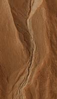
Oooh, that's pretty...
|
(crop from ESP_018827_2640 )
Looks like a LOT of rock fell from the scarp face, slammed into the ground below, exposing some ice beneath the surface..?
Posted by: elakdawalla Oct 6 2010, 08:30 PM
Although I'm not totally sure I agree with the ice part of the interpretation (because that spot in the fan should be an area of deposition, not exposure, if I'm seeing things correctly), that is a well spotted find!
Posted by: Stu Oct 6 2010, 08:36 PM
Hmmm. Good point about the deposition, hadn't thought of that... Just thought it was a fascinating view.
Wow... just spotted this is my 4000th post. Doesn't time fly when you;re having fun?
Posted by: ngunn Oct 6 2010, 09:54 PM
'Dry water' has just been in the news: http://www.telegraph.co.uk/science/science-news/7964109/Scientists-create-dry-water.html
Apparently if you subject the powder to pressure you can squeeze the water out of it. What I don't know is whether this form of water is more resistant to sublimation under Martian conditions than ordinary ice. It does make me wonder though if something akin to 'dry water' could be present in Martian sediments. If so then the transient appearance of ice in avalanche debris might not be out of the question.
Posted by: vikingmars Oct 7 2010, 12:33 PM
Great work Phil ! You are really the leading landing sites imaging cartographer ! CONGRATULATIONS.

Although they are not of your quality work, I did also some tries in 2007 combining several HiRISE images together to get more details for Viking and MPF :
- VL1 : http://www.unmannedspaceflight.com/index.php?s=&showtopic=4508&view=findpost&p=97402
- VL2 : http://www.unmannedspaceflight.com/index.php?s=&showtopic=4532&view=findpost&p=97712
- MPF : http://www.unmannedspaceflight.com/index.php?s=&showtopic=4521&view=findpost&p=97572
Enjoy !
Posted by: fredk Oct 10 2010, 02:38 AM
So maybe there were chunks of ice that came down with the avalanche, and those whitish areas are the remnants of the last of them as they sublimate away. That would mean it was a recent avalanche, but we have caught them in action before...
Posted by: Juramike Oct 10 2010, 04:44 AM
..has been around since 1968. It is the "potential" application extensions that made news.
Official ACS press release http://portal.acs.org/portal/acs/corg/content?_nfpb=true&_pageLabel=PP_ARTICLEMAIN&node_id=223&content_id=CNBP_025778&use_sec=true&sec_url_var=region1&__uuid=6e367c28-02d5-4c21-ad2c-a37d6f908f2c.
It is basically a http://en.wikipedia.org/wiki/Gel#Hydrogels, except it is encapsulated in silica rather than in a polymer. (Think of it as teensy drops of water surrounded by a silica coating.) The silica prevents evaporation, but allows the diffusion in of gases through the silica barrier. (I'm guessing the strength of the water network prevents the individual water molecules from easily escaping.)
I'm not sure how easily this could be formed naturally on Mars....
Posted by: nprev Oct 10 2010, 05:10 AM
Yeah, that looks like a pretty unlikely substance, all right.
Hmm. Why does it have to be ice? We've seen Spirit's bum wheel churn up all sorts of bright deposits, including white stuff. Maybe it's a big deposit of MgO, or even CaCO3. If so, dust deposition will gradually cover it up.
Posted by: lavaphile Oct 19 2010, 05:40 PM
The blue color is typical of ice in HiRISE "enhanced" color images. These cliffs are along the margin of the polar cap and are composed of mostly ice (H2O) with coloring/coating by dust. So I think the blue is exposing clean ice from broken blocks that fell to the base of the cliff. What is really hard to appreciate from these images is just how steep and tall these cliffs are...
Posted by: sgendreau Oct 21 2010, 10:41 PM
About 700m (2500 ft) and darn near vertical.
Posted by: monitorlizard Oct 29 2010, 09:36 PM
Don't really want to start a new topic, so I'll put this here. I've noticed that the weekly releases of new images on the uahirise.org website have only had one extended phase (ESP prefix) image per week, with the rest being primary science phase (i.e., older) images. I found something from the September 2010 MEPAG meeting in a presentation titled "Current Orbiter Capabilities for Future Landing Site Selection" that might help explain this:
"HIRISE: Team has used longer and more frequent warm-ups to compensate for increasing ADC (analog to digital converters) bit flip errors. Considering an onboard annealing sequence which ground testing indicates could reduce errors by breaking up and dispersing the ADC contamination."
Later in the presentation it says "need to use the capabilities conservatively where instrument and/or spacecraft limitations dictate." Also of interest is where it reports CRISM capabilities have decreased because of degradation of its gimbal (used for high resolution) and coolers (needed for IR observations). I don't think these degradations are reversable.
Hopefully, HiRISE can successfully do the annealing fix before maximum data transmission rates are reached again next year.
Posted by: nprev Oct 30 2010, 12:13 AM
Rats. Nothing serious (yet), but it always hurts to see spacecraft begin to age.
At least the restart issue seems to have been cured, so hopefully the ADCs can be healed as well.
Posted by: monitorlizard Oct 30 2010, 06:33 PM
I should add, for those who are interested in CRISM, that the same presentation said the following about future CRISM operations:
"Plan: Use full VNIR/IR capability for 2 weeks every other month in mini-campaigns focused on high priority items(especially during periods of higher data rate)
--VNIR-only mode can be used at other times (but avoid major dust events)
-----VNIR (0.4 to 1.1 micrometer) aqueous mineral signatures are limited to ferric minerals
Bottom Line: Full-resolution VNIR/IR targeting reserved for high priority targets"
It's sad to see the instrument in decline, but cryocoolers like CRISM's are hard working pieces of machinery that can't be expected to last forever. They sure did a good job until now, though.
Posted by: Stu Nov 17 2010, 08:20 PM
|
Colourisation of 'rock bridge' seen on one of today's new HiRISE releases (seen before, but still cool!) http://hirise.lpl.arizona.edu/PSP_001420_2045
Posted by: vikingmars Dec 23 2010, 10:52 AM
Some stunning pics of the interior of giant Mars pits...
Link : http://news.nationalgeographic.com/news/2010/12/photogalleries/101221-mars-pits-pictures-photos-science-nasa-space-caves/#/mars-pits-larger_30636_600x450.jpg
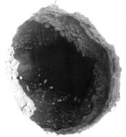
|
Enjoy !
Posted by: SteveM Dec 23 2010, 04:20 PM
Link : http://news.nationalgeographic.com/news/2010/12/photogalleries/101221-mars-pits-pictures-photos-science-nasa-space-caves/#/mars-pits-larger_30636_600x450.jpg
Enjoy !
Steve M
Posted by: Tesheiner Dec 23 2010, 04:41 PM
Here's the page at the HiRISE site: http://hirise.lpl.arizona.edu/ESP_019997_1975
Look at the bottom for some geometry info.
Posted by: helvick Dec 23 2010, 06:56 PM
Well the info lists http://hirise.lpl.arizona.edu/PSP_003317_1975 as an anaglyph product for the image this enhanced clip has been taken from so one of the wizards here might be able to reprocess both similarly and then produce an anaglyph, the convergence angle looks pretty high to me but I'll let others comment on whether that makes this unusable or not.
Posted by: ElkGroveDan Dec 23 2010, 06:59 PM
This is the link to the http://hirise-pds.lpl.arizona.edu/download/PDS/EXTRAS/ANAGLYPH/PSP/ORB_003300_003399/PSP_003317_1975_ESP_019997_1975/PSP_003317_1975_ESP_019997_1975_RED.JP2 image.
Even without the enhancement it should be not a problem to calculate the depth of the bright sunlit segment.
Posted by: djellison Dec 23 2010, 08:59 PM
Approx 300m across and 180m deep - I did the trig on the distance from the side to the shadow using the illumination angle some time ago.
Posted by: SteveM Dec 24 2010, 08:11 PM
Steve M
Posted by: antipode Dec 24 2010, 09:09 PM
Its very easy to imagine the bottom of that hole continuing as a lava tube under what seems to be an overhang at the right of that image, and possibly all the way through to the left hand side. May be an illusion of perspective and lighting though.
p
Posted by: OWW Jan 12 2011, 12:52 AM
http://hirise.lpl.arizona.edu/ESP_020058_1865 in the latest PDS release.
Similar to the http://hirise.lpl.arizona.edu/ESP_016022_1420 or not?
Posted by: JohnVV Jan 12 2011, 02:44 AM
"Weird looking terrain in the latest PDS release."
it's odd but then this is Libya
http://spaceflight.nasa.gov/gallery/images/station/crew-18/hires/iss018e014770.jpg
http://www.spaceref.com/news/viewsr.html?pid=30394
Posted by: tharrison Jan 12 2011, 05:11 PM
Similar to the http://hirise.lpl.arizona.edu/ESP_016022_1420 or not?
No, the landforms in ESP_020058_1865 are thought to be lithifed aeolian dunes that have been partially eroded. This is seen in multiple places around Arabia Terra. That HiRISE image was actually a case where we here on the CTX science ops team saw that terrain in a CTX image and then specifically asked HiRISE to shoot it for a higher-resolution look. Attached is a subframe of CTX P17_007571_1859_XI_05N335W, which covers the area of that HiRISE image (it's a little murky, as Arabia Terra is often cloudy).
No one really knows what the heck is going on in the stuff in western Hellas (referred to informally as "taffy pull terrain").
~Tanya
|
Posted by: lyford Mar 22 2011, 02:56 AM
I am a twitter abouthttp://twitter.com/HiRISE/status/50002881004306432.... ???
Posted by: tharrison Mar 23 2011, 10:43 PM
I'm pretty sure it has something to do with this: http://www.skyandtelescope.com/news/home/117806243.html
Posted by: marsbug Mar 23 2011, 11:05 PM
For convinience here is the http://www.lpi.usra.edu/meetings/lpsc2011/pdf/2314.pdft from LPSC. It makes for interesting reading, but I suggest great caution in declaring liquid water found, much less a habitable environment. Hopefully CRISM observations will make a stronger case or put this to bed.
Posted by: sgendreau Mar 24 2011, 04:40 AM
In the literature, McEwan has been a critic of wet formation mechanisms. I don't think you need worry that he'll overreach.
Posted by: marsbug Mar 25 2011, 11:30 AM
Thats good to know.
Posted by: ElkGroveDan Apr 22 2011, 03:32 PM
Discussion of paper on Spectral Evidence for Liquid Water on Mars, LPSC 2011, Renno and Mehta moved
HERE -> http://www.unmannedspaceflight.com/index.php?showtopic=6949&st=0
Posted by: climber Aug 21 2011, 02:06 PM
Another cave: http://www.onorbit.com/node/3681
Posted by: Lewis007 Sep 9 2011, 07:05 AM
An article about the recent problems with HiRISE camera
Operators of NASA's Mars Reconnaissance Orbiter are resuming use of the mission's highest resolution camera following a second precautionary shutdown in two weeks. The High Resolution Imaging Science Experiment (HiRISE) instrument powered off on Aug. 27 and again on Sept. 6. In each case, commanding for an observation was not properly received by the memory module controlling one of the instrument's 14 electronic detectors (CCDs, or charge-coupled devices). Between those two incidents, the camera successfully resumed observations for five days using its other 13 detectors. The second entry into the power-off, thermally protected mode occurred during an attempt to add use of the 14th detector. The camera is resuming observations with 13 detectors today while plans are developed for other diagnostic tests.
The detector remaining out of use pending further tests lies at the outer edge of the lineup of detectors. It is one of 10 detectors observing through red filters. The other four are pairs observing through blue-green or near-infrared filters, yielding color images in the central portion of the observation. Without this 14th detector, observations can still cover as much area, in images slightly narrower, but longer, than usual. The typical cross-track width of a HiRISE image without use of that detector is about 3.4 miles (5.4 kilometers), compared to about 3.7 miles (6 kilometers) when using all detectors. The coverage area can be maintained by extending the length of the observed area by about 10 percent.
HiRISE has returned more than 20,400 observations since the Mars Reconnaissance Orbiter reached Mars in 2006. Each observation by this telescopic camera covers several square miles, or square kilometers, and can reveal features as small as a desk. The Mars Reconnaissance Orbiter completed its primary science phase in 2008 and continues to work in an extended mission. HiRISE Principal Investigator Alfred McEwen, of the University of Arizona Lunar and Planetary Laboratory, Tucson, said, "This isn't a significant loss to the science capability of HiRISE. However, it is a sign that the instrument is aging and could suffer further degradation in the future."
Source: http://www.marsdaily.com/reports/Orbiter_Resumes_Use_of_Camera_999.html
Posted by: Fran Ontanaya Dec 2 2011, 03:16 PM
A bright wispy feature from the image I downloaded to give feedback on HiView:
http://hirise.lpl.arizona.edu/ESP_024579_1790
|
Powered by Invision Power Board (http://www.invisionboard.com)
© Invision Power Services (http://www.invisionpower.com)