Printable Version of Topic
Click here to view this topic in its original format
Unmanned Spaceflight.com _ MRO 2005 _ HiWish
Posted by: ElkGroveDan Jan 20 2010, 05:16 PM
http://www.uahirise.org/suggest/

|
Posted by: elakdawalla Jan 20 2010, 08:26 PM
I thought we needed a new thread to post about all of our own suggestions! I'm curious what other people are picking. I wrote about my first picks http://www.planetary.org/blog/article/00002312/: a spot identified in my one and only peer-reviewed publication, and some interesting-looking fluvial features.
Posted by: elakdawalla Jan 20 2010, 11:08 PM
I inquired about what would be a reasonable turnaround time to expect on HiWish images. The shortest conceivable time between request and image being delivered to the PDS is two months, which is pretty amazing when you think about it, but in reality the lag will probably be longer. Images get delivered to the PDS on a monthly basis.
Posted by: cassioli Jan 21 2010, 07:57 AM
I really wish to have a second/third/fourth look to Mars caves region (Arsia mons), but diagonally rather than horizontally, both to better estimate caves depth and to figure out if "normal" caves with vertical entrance exist.
Posted by: ngunn Jan 21 2010, 08:44 AM
Similarly, I'd like to see verification of the 3D structure of the putative natural arch.
Posted by: djellison Jan 26 2010, 04:42 PM
I've gone for some Barchan Dunes previously seen in March 2008 - to monitor for dune migration and evolution, particularly as there are some hugely long tendirl like dune features that might hint at shifts in prevailing winds. http://hirise.lpl.arizona.edu/PSP_007676_1385
I'm temping to try and point out the lack of colour coverage over Eagle Crater (Backshell, parachute, lander) and the Spirit Lander / backshell - apart form monitoring what the parachute's are doing in the wind, and the evolution of the impact crater made by Opportunities back shell, I'm sort of struggling a bit. I need a scientist to justify it with photogrammatic reasons.
Posted by: Den Feb 4 2010, 05:57 PM
I propose photographing numerous channels east of Hellas.
Their lower parts sure look a lot like ancient rivers and even delta sedimentation (for example, http://www.google.com/mars/#lat=-41.450961&lon=99.184570&zoom=7&map=infrared - note completely covered over largish crater a bit to the left from center). Ancient water history, yay!
Going "upriver" we eventually reach highlands and what looks to me like volcanic plains created by Tyrrhena Patera eruptions.
Unless I am mistaken again and this terrain is not volcanic. It has confusing "young" look with crisscrossing ridges:
http://www.google.com/mars/#lat=-28.149503&lon=120.234375&zoom=6&map=infrared
On one hand, it looks like very wide lava flows. OTOH, lava flows covering territory much bigger than Olympus Mons base? Is this realistic?
Posted by: djellison Mar 4 2010, 04:10 PM
Imaging the Spirt Lander/Backshell/Parachute/ is DONE 
"ID 43290
Title Spirit Lander Backshell Heatshield and Parachute in color
Suggester djellison
Suggestion Date 2010-01-31
Number of Observations 1
Primary Theme Future Exploration/Landing Sites
Secondary Theme Landscape Evolution
Retired By ESP_016677_1650
Date Success 2010-02-11"
If I'm reading that right - the time between my suggestion and the image being taken is just 12 days. I'm going to make the assumption it was planned for anyway.
Posted by: djellison Mar 4 2010, 04:31 PM
Or maybe it's not actually been taken yet - it was just added to the list of future observations on that date.
Beyond awesome, can't wait to see it!
Posted by: Stu Mar 4 2010, 04:35 PM
(cough) fix! (cough)

That will be a very interesting image. Maybe we'll see one of those pesky Gusevian Gorillas pulling bits off it... 
Posted by: mhoward Mar 4 2010, 04:41 PM
What does "Retired By ESP_016677_1650" mean? I'm reading that as saying the requested observation already was done so it won't be repeated, but it's not really clear.
Posted by: djellison Mar 4 2010, 05:04 PM
It means it's been scheduled as an observation, so the 'request' to take the image is now retired.
I don't know if that image ID is in the past, or the future, so I don't know if it's been taken or not. I can't find a place to tell me the current orbit number to figure it out.
Posted by: djellison Mar 4 2010, 05:07 PM
Via twitter - I've learnt it was a coincidence
Posted by: DataMiner Mar 4 2010, 08:48 PM
Just a little explanation about suggestion retirement: We try to retire target suggestions as early as possible in the planning phase. Since we have multiple cycles being planned simultaneously we want to make sure that once a target has been picked up for planning in one cycle, it won't get picked up again by another. So suggestions often get retired several weeks before the observation is taken.
As for your target, Doug, we do have it on the ground, but I think we will probably unretire it. ESP_016677_1650 fell a little too far east of the Spirit landing site area, but covered enough of your suggestion footprint to cause it to be automatically retired.
Posted by: djellison Mar 4 2010, 08:50 PM
Ooo - does that put that color section inbetween my proposed target, and the previous ones straight over the columbia hills and Spirit's current location? We could end up with most of the traverse being documented in color, which would be very nice (and sort of a sensible thing to do anyway I would have thought)
Opportunity did us a favour by driving south, down HiRISE CCD paths.
Thanks for the details - I'm sure the selecting planning and sequencing is more complex than I'm imagining it. Keep us posted!
Posted by: DataMiner Mar 4 2010, 09:15 PM

Opportunity did us a favour by driving south, down HiRISE CCD paths.
Thanks for the details - I'm sure the selecting planning and sequencing is more complex than I'm imagining it. Keep us posted!
Yeah, the color swath on this one is right over columbia hills and home plate, although I don't think there is much, if any *new* color coverage, since this observation is part of a monitoring project. Just so you know, this observation will most likely be released the first week of April. We still need some time to validate it, and there's also a big data gap in one of the red ccd's that *might* still get filled in (although I think it is unlikely at this point).
Posted by: Bobby Apr 8 2010, 08:53 AM
I ran across a website from our local TV Station Channel 5 here in Seattle where the public can decide
what HiRise will photograph next.
Here is the King 5 article site: http://www.king5.com/news/slideshows/New-photos-of-Mars-with-locations-picked-by-the-public-90029622.html?gallery=y&c=y&ref=%2F
and here is the site where we can decide what Hirise should take pictures of next: http://www.uahirise.org/hiwish/
I might suggest HiRise take pictures of Endeavor Crater and the area Opportunity will drive to get there?
Merged with existing HiWish thread - Mod
Posted by: djellison Apr 8 2010, 11:45 AM
Did it not occur to you that they might already have imaged those areas?
Posted by: Habukaz Sep 5 2016, 10:21 AM
Through http://www.uahirise.org/hiwish/view/126478 I recently learnt how remarkably unremarkable remarkable things in CTX images might look in HiRISE images.
This what the target looked like in CTX observation http://viewer.mars.asu.edu/planetview/inst/ctx/F03_036888_2278_XN_47N098W#P=F03_036888_2278_XN_47N098W&T=2: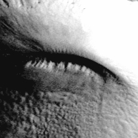
It more or less looked like a ridge that had (or consisted of) spines of some sort (and it looked liked the narrow shadows behind the ridge confirmed it; although in hindsight, maybe they have improper orientations).
This is what the ridge looks in the http://www.uahirise.org/ESP_046620_2275:
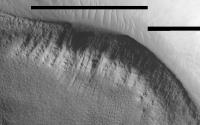
|
Not remarkable at all, and I basically got cheated by Mars.
Posted by: wildespace Jul 15 2018, 10:58 AM
My still open HiWish
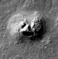
|
I really want to know what that feature looks like in high-rez and under different sun angles.
Cydonian sphinx, move over.

Posted by: Adam Hurcewicz Jul 15 2018, 11:47 AM
|
|
I really want to know what that feature looks like in high-rez and under different sun angles.
Cydonian sphinx, move over.
Wow! Where is it on Mars? Any other images are?
Posted by: wildespace Jul 15 2018, 02:05 PM
6.712°, 92.713°E
https://www.uahirise.org/hiwish/view/153460
There's only one CTX image covering that feature (at least that I'm aware of): http://viewer.mars.asu.edu/planetview/inst/ctx/B17_016403_1878_XN_07N267W#P=B17_016403_1878_XN_07N267W&T=2

|
P.S. don't forget to check out the "exlamation mark" nearby: https://www.uahirise.org/ESP_020794_1860
Posted by: marsophile Sep 14 2018, 05:33 AM
Have any science images been taken of the night side of Mars? According to this link
https://www.universetoday.com/96576/hirise-camera-to-attempt-imaging-curiositys-descent-to-mars/
images of the night side were taken in preparation for imaging the Curiosity descent, but they were dumped and not returned to Earth. Night images may have been taken for calibration purposes but I'm not sure if they were returned.
Imaging the night side might seem like a waste of time but surprises do happen. Perhaps Aurora phenomena or meteor trails might be seen, or even hotspots, if the imager is sensitive to infrared.
Powered by Invision Power Board (http://www.invisionboard.com)
© Invision Power Services (http://www.invisionpower.com)