Printable Version of Topic
Click here to view this topic in its original format
Unmanned Spaceflight.com _ MRO 2005 _ HiRISE DEM's
Posted by: djellison Apr 13 2008, 10:46 AM
Late last week I stumbled upon a few HiRISE derived DEM's (Randy Kirk works his magic once again!)
http://webgis.wr.usgs.gov/ftphirise/index.jsp (URL now down)
I'm working on both Vic Crater and the Columbia Hills. Fortunately, now I've got a Mac, I can use ISIS. I've figured out a fairly simple flow ( isis2raw as 16 bit unsigned, and then imported into Photoshop ) to take DEM CUB's and make 16 bit PNG's 
Just to demo how important that is for me as an animator - sliced comparisons of 8bit vs 16 bit.
A busy week unfortunately, but animations of various sorts are in the pipeline.
|
|
Posted by: Bjorn Jonsson Apr 13 2008, 10:15 PM

In general, I find 8 bit DEMs almost useless. They can sometimes be used by converting them to 16 bits and smoothing them - I almost never use them without fairly extensive processing.
Posted by: djellison Apr 14 2008, 10:41 AM
Still figuring out the best way to explore and display these dems - especially the Colubia Hills.
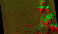
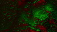
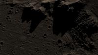
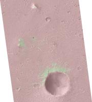
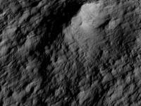
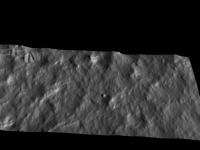
Meanwhile - a revisit of an idea I had some years ago using a MOC dem. This is the 'power goodness' display - lit from the north in green, the south in red. A wider angle, and a close angle.
|
|
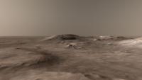
Posted by: djellison Apr 15 2008, 07:33 AM
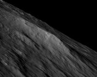
And using the Victoria one to simulate shadowing with the sun high in the sky, and as low in the sky as it gets ( 63ish degrees )
http://www.planetary.org/blog/article/00001395/
D
Posted by: djellison Apr 20 2008, 07:30 PM
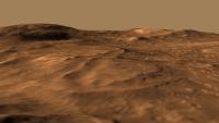
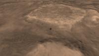
I've had a hard time trying to do justice to these data sets, the Columbia Hills and the Victoria Crater HiRISE Dem's.
Here's my effort for the Columbia Hills
http://www.unmannedspaceflight.com/doug_images/columbia_dem_480.mov
(4.8 meg)
Victoria Crater (with added 'rover') tomorrow
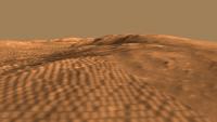
Posted by: djellison Apr 21 2008, 09:04 AM
And Victoria crater
http://www.unmannedspaceflight.com/doug_images/victoria_dem_480.mov
3.8 meg.
Enjoy.
D
Posted by: Stu Apr 21 2008, 01:07 PM

Cooler than a penguin sat on an iceberg, sucking an ice lolly and wearing underpants full of ice. 
Posted by: ilbasso Apr 21 2008, 05:27 PM
Agree, very very cool!
All that's needed to make us happy is to tack onto the end of the movie a little video of Oppy SAFELY driving out of VC!!
Posted by: djellison May 5 2008, 01:14 PM
I rendered a jumbo 4kx4k fisheye then polar-to-rectangled it back into this.
It's hard to get the rover wheels to sit on the terrain when the terrain doesn't actually appear until you render it
|
|
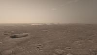
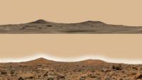
Posted by: djellison May 15 2008, 11:24 AM
I hope you all enjoyed the movies at full res courtesy of Emily on TPS's Blog
I'm open to requests etc. My favorite thing to play with is lighting, this is a particularly nice shot, although it does bring out the trouble with the CCD's.
|
Posted by: djellison May 19 2008, 04:12 PM
http://antwrp.gsfc.nasa.gov/apod/ap080519.html
Doug
Posted by: Stu May 19 2008, 04:20 PM
Well done! About time your work on these DEMs was recognised properly.
Posted by: ustrax May 19 2008, 04:50 PM
Magnifique! 
Posted by: nprev May 19 2008, 05:05 PM
Bra-VO!!! Superbly rendered...and appropriately recognized at last!!!
Posted by: djellison May 19 2008, 05:09 PM
Just for fun, I actually have a better version on the burner right now Clouds, sun, haze etc. Results over the next few days.
Posted by: john_s May 19 2008, 05:31 PM
These are great- nice job Doug!
I'm still looking forward to seeing more near-surface images or animations from HIRISE DEMs of other places that we haven't sent rovers to- these could be even more interesting than views of the familiar Spirit and Opportunity landscapes.
Posted by: djellison May 19 2008, 05:38 PM
Well - there are four done for various Phoenix sites, but, how can I be nice about this....
They're dull. Very very dull.
I think many of the MSL candidates will get a DEM treatment, hopefully those will make it out the door as well.
Doug
Posted by: climber May 19 2008, 07:34 PM
Your work put everything in a new perspective and that's what exploration is all about
Hat off
Thanks
Posted by: dilo May 19 2008, 07:38 PM
Congrats, Doug!
Unfortunately, the movie is almost invisible on my PC (it starts very slowly, then stops download after few frames...). Moreover, I do not find the old Emily's blog movies! 
Some help???
Posted by: ngunn May 19 2008, 08:03 PM
I thoroughly enjoyed seeing these on TPS - why did I forget to say so right away? - Vertical scale looks realistic too, though Victoria's cliffs seem a bit rounded off.
Posted by: djellison May 19 2008, 08:37 PM
The cliffs are a bit rounded off, just a symptom of the resolution (1m per 'pixel' for elevation) really.
And, to the very best of my abilities, they are accurate for elevation, as close as I could possibly make it. The clincher is that rendering the Columbia one from the landing site - it's a perfect replica of the success pan images of the hills.
The proper movies are here - http://planetary.org/blog/article/00001423/ - although I intend to update the Columbia one later today - links later Randy Kirk got some nice emails about them, which is good because it's his hard work that made the data, and his kindness that put it 'out there' for nutters like me to play with.
Doug
|
|
Posted by: Del Palmer May 19 2008, 09:19 PM
Ah, I knew that was one of yours, yet when I checked APOD this morning (10:00), your name wasn't in the credit line (which I thought was a bit out of order).
|
Posted by: djellison May 19 2008, 10:14 PM
I didn't know it had been posted on there. I got an email from Randy who had got emails from people saying how cool it was. He told me, and then told Bob to edit the descriptor. Then we realised is talked about MSSS / MOC / MGS, and tweaked that as well. Then I realised Bob had linked to my highly unfinished and quite broken soon-to-be-blog.
Posted by: djellison May 19 2008, 11:19 PM
Finished thing is now here : http://www.dougellison.com/?p=5
Enjoy
Posted by: ElkGroveDan May 19 2008, 11:34 PM
Not found 
|
Posted by: nprev May 19 2008, 11:48 PM
Yeah, went hunting myself...no joy.
Did enjoy the "sermon" post, though...
Posted by: dilo May 20 2008, 06:36 AM
Now I can see them and are superb! Thanks.
What do you think about adding a local high-res texture based on last panoramas, all around the MERs? I think this would add dramatic realism, reducing also the innatural contrast between rovers and smoothed DEM terrain...
Posted by: djellison May 20 2008, 06:58 AM
Two problems with that. If I had, say, 1cm/pixel imagery around the rover - then my image map would have to be 1cm per pixel. There isn't an easy way to accurately place a second texture on top of the MRO one without actually making the whole thing 1cm pixel. That would mean a texture 800,000 pixels across. No cigar. I went down that road with CTX - on - HRSC DEM's. It was a bloody nightmare, and the results didn't pay off.
The other problem is that at the moment, it all sits together quite nicely. Panoramas don't make good maps very easily.Only a few M from the rover, it's warped and distorted beyond the point of usefullness. ( for eg - http://pds-imaging.jpl.nasa.gov/data/mer2-m-navcam-5-mosaic-ops-v1.0/mer2om_0xxx/browse/navcam/site0126/2nn792ilfaqvrtcyp1908l000m2.img.jpg ) and for the brief moment we are close to the rover, it wouldn't be worth the hassle.
Adding terrain meshes to the Victoria crater one is something I've already had a look at ( I thought the capes might benefit ) but given up on. The meshes themselves just don't stand up to the level of quality to make it worth while.
Always helps to actually publish the damn thing
http://www.dougellison.com/?p=5 is now working. That, for now, is my last treatment of the Columbia one. What I'd REALLY REALLY love to be able to do, is some sort of realtime thing where you can drive around it on a quad bike. I'm sure Half Life 2 could manage it, but I just don't know how to put a million polygons into a game like that Doug
Posted by: climber May 20 2008, 07:31 AM
When I've opened up the "view new posts" I've seen your message here above (I know that you're ok by now) and then this one from Doug from the "Lidar" topic
"Upgrade the DSN to the proposed 400 x 12m dish arrays, and put a 6m dish on the spacecraft - then you can do 320 Mbps from Mars to Earth"
When you put them together aside, it's kind of, what, injustice? Frustating?

Posted by: dilo May 21 2008, 10:26 AM
Doug, I perfectly understand the issue you described, I had same problem when I tried to realize a "power of 10"-like movie initially showing all the red planed and then zooming on one rover (Emily suggested such idea long time ago, do you remember?).
Now I solved the issue by making a dedicated POV-RAY script who shades between various textures with different scales, anyway I abandoned the mars-zoom idea due to absence of time (for the moment!). Anyway, this idea is working well only if you strongly zoom on a planar surface, so is not applicable to your 3D DEM... I think the best way to avoid use of mega-textures is to overlap a local, texturized "mini_DEM" surface on the big one, eventually using 3D terrain model computed from MER stereo cam (someting like this was available on venerable "Maestro" JPL software... now I do not know where to find it). In the outer parts, such mini-DEM should appear progressively shaded in order to have a smooth transition effect. I know is not simple, it is only a suggestion for possible, future works...
About your last treatment of the Columbia movie, I like it very much. My only observation is about the colors: personally, I would like more saturation, with different hue between red terrain and a yellow artificial sky...  What do you think about?
Posted by: djellison May 21 2008, 10:42 AM
I think you should have a go yourself
I know what you mean about the colour. The sky colour is, imho, quite accurate. The ground colour is a little washed out. The simulation from here http://www.marslive.co.uk/?p=5 is a better looking product, BUT, the orientation of the sun when rendering, and when the HiRISE image was taken would contradict. The sun has to be to the west, and reasonably high, to be honest to the shading of the texture on the surface.
I'm not touching it again for a long time. I'm happy to put the 16bit PNG DEM up somewhere if you want to grab it and have a go.
Doug
Posted by: mhoward May 21 2008, 12:04 PM
I'd love to try using it... maybe in a month or two. It would be neat if it were possible to use it in MMB, with rover POV images overlayed on a modeled background. But I won't have time to even think about that for a couple months at least.
Posted by: Kevin Jun 15 2008, 04:14 PM
I would love to take a stab at this in a realtime stereo visualization environment. If the 16bit PNG DEM were available I could probably get something up and running in a day or two. It would be a real test for my system.
Cheers,
-Kevin
Posted by: djellison Oct 13 2008, 09:18 PM
I prepared this for someone else - thought forum people might enjoy it
1) Install ISIS 3 - instructions here http://isis.astrogeology.usgs.gov/documents/InstallGuide/index.html
2) While letting that happen - grab one of Randy's DEM's - I'm using the Victoria Crater bundle as an example
3) Find DEM_1m_VictoriaCrater.cub.gz (it's in the ISIS_EQUI360_OC folder ) and expand it
4) Run isis2raw
5) In the 'FROM' window - point to the .cub
6) Copy and paste the path and filename into 'TO' - but change the extension to .dem or something simiar
7) U16BIT data type ( screenshot attached)
8) Hit Run.... if this bit doesn't work - it's almost certainly your ISIS3 installation that needs looking at, make sure you got all the Base Data.
9) Find the .cub and open in text edit and find this part...
/* Core description */
CORE_ITEMS = (1278,1694,1)
10) Open Photoshop, and open the .dem.raw that ISIS3 produced
11) Width is the first of those three figure under CORE_ITEMS. Height is the second. Depth should be 16 bits, Byte Order as IBM PC, Header as size 0
12) Hit OK
13) Save out as 16 bit PNG, celebrate, have lunch, dump into your favourite animation package.
Posted by: djellison Oct 19 2008, 06:02 PM
Gale Crater dem up
http://www.dougellison.com/?p=44#content
Doug
Posted by: mhoward Oct 19 2008, 06:51 PM
OK, now that's cool.
Posted by: thare Nov 13 2008, 05:14 AM
For those that don't want to or can't install ISIS3 I thought you might want to know how to do this using GDAL.
1.) Install FWTools (Lunix, Windows) or GDAL framework for Macs:
Linux, Windows: http://fwtools.maptools.org/
mac: http://www.kyngchaos.com/wiki/doku.php?id=software:frameworks
--Now I don't have experience getting these mac frameworks working. But I have heard it is easy.
once GDAL is installed and working, run:
1.) gdalinfo -stats DEM_1m_VictoriaCrater.cub (or GIS Tiff)
--note the min and max.
2.) gdal_translate -of PNG -ot UINT16 -a_nodata 0 -scale stats_min stats_max 1 10000 DEM_1m_VictoriaCrater.cub DEM_1m_VictoriaCrater_unit16.png
where
-of PNG = output format PNG
-ot UNIT16 = output type Unsgned 16 bit Int
-a_nodata 0 = Set all input NULL value to 0 on output
-scale in_min_value in_max_value out_min_value out_max_value = will apply a linear scale from input to output.
then just the input and output filenames.
That is it. It would be nice to know if this method works for anyone.
-thare
Note: I picked 10000 as the max scaled output but you may have to play with that value for your 3D app.
1) Install ISIS 3 - instructions here http://isis.astrogeology.usgs.gov/documents/InstallGuide/index.html
...
13) Save out as 16 bit PNG, celebrate, have lunch, dump into your favourite animation package.
Posted by: djellison Sep 21 2009, 10:13 PM
Doing an updated 2009 version of my Columbia Hills DEM. Bit of a bug in the first render, but should be finished tomorrow night.
Just got a new Core i7 860 CPU. My Q6600 has been retired to status of render node. New rig does these frames in about 35 seconds. Old rig in about 60 seconds - so I've nearly trebled my rendering power
|
Posted by: djellison Sep 22 2009, 08:13 PM
FINISHED
http://www.dougellison.com/?p=82
Not perfect - but it's about the best I can do.
Posted by: Roby72 Sep 22 2009, 08:54 PM
Like flying around - brilliant !
Robert
Posted by: elakdawalla Sep 22 2009, 09:22 PM
Love the dusty quality of the atmosphere. An easy post for tomorrow
--Emily
Posted by: PDP8E Sep 22 2009, 09:34 PM
Hi Doug,
unbelievable job on the fly around! Thank you.
You say its the best you can do....but for me...that fly-around is the best I could ever dream about doing.
Cheers
Posted by: remcook Sep 23 2009, 07:13 AM
I love how Spirit appears suddenly behind Home Plate. Very dramatic! Great job!
Posted by: imipak Sep 23 2009, 08:15 AM
Superb.
Posted by: antipode Sep 24 2009, 08:04 AM
on Mars, on Mars, on Mars...

Thankyou.
p
Posted by: Stu Sep 24 2009, 01:40 PM
Ah, always nice to meet a fellow KSR fan...
Posted by: ustrax Sep 24 2009, 02:19 PM
Doug, that's just...beautiful. With all the beauty the word can carry. Thanks.
Posted by: climber Sep 24 2009, 04:38 PM
I knew you were not going to sent the MER team "only" a postcard for the 3rd anniversary...
Very dramatic and beuatifull indeed, thanks.
Posted by: JRA Sep 25 2009, 02:50 AM
Great animation djellison. I really like it a lot.
I never knew about the hi-res topography data on USGS, so I decided to download some of it for myself to play around with. I went and downloaded Victoria crater and it has everything in a .tif format (as well as the .cub files) and it all works except for the DEM .tif file. When I load it up in photoshop it's all black. I went and downloaded GDAL and loaded up the DEM .cub file and it shows up in there. I exported it as a .tif from there, but it still does not show in photoshop. Does anyone know what I'm missing here?
Posted by: elakdawalla Sep 25 2009, 04:06 AM
I haven't tried to work with the DEM data at all, so this is a shot in the dark, but my first question would be: is the file 16-bit, and if so, is all the data down in the first 12 bits? That's one reason things can look black in Photoshop. Check Image > Adjust > Levels and see if the histogram shows anything at all.
Posted by: JRA Sep 25 2009, 04:16 AM
The file is 16-bit. And the histogram seems to be blank.
Posted by: elakdawalla Sep 25 2009, 04:32 AM
Well that's pretty much all my ideas. Guess you'll have to wait for the Sun to rise on the UK
Posted by: djellison Sep 25 2009, 07:33 AM
This is the only way I know - so far - and it's very long, convoluted, and I'm SURE there is a better way to do it - but it works.
1) Install ISIS 3 - instructions here http://isis.astrogeology.usgs.gov/document...uide/index.html
2) While letting that happen - grab one of Randy's DEM's - I'm using the Victoria Crater bundle as an example
3) Find DEM_1m_VictoriaCrater.cub.gz (it's in the ISIS_EQUI360_OC folder ) and expand it
4) Run isis2raw
5) In the 'FROM' window - point to the .cub
6) Copy and paste the path and filename into 'TO' - but change the extension to .dem or something simiar
7) U16BIT data type ( screenshot attached)
8) Hit Run.... if this bit doesn't work - it's almost certainly your ISIS3 installation that needs looking at, make sure you got all the Base Data.
9) Find the .cub and open in text edit and find this part...
/* Core description */
CORE_ITEMS = (1278,1694,1)
10) Open Photoshop, and open the .dem.raw that ISIS3 produced
11) Width is the first of those three figure under CORE_ITEMS. Height is the second. Depth should be 16 bits, Byte Order as IBM PC, Header as size 0
12) Hit OK
13) Save out as 16 bit PNG, celebrate, have lunch, dump into your favourite animation package.
I'm hoping to figure out a workflow that involved just ImageJ or Photoshop without ISIS3 (as it's a hell of an install, and a pain in the butt to get running for a temperamental artists like me )
Posted by: djellison Sep 25 2009, 02:45 PM
1080 Full HD version
http://www.archive.org/details/ColumbiaHills2009DemAnimation
Thanks to Gary Murphy for suggesting archive.org as a place to put it
Posted by: PhilCo126 Sep 25 2009, 04:57 PM
Superb work Doug, it didn't go unnoticed on other websites & blogs 
Posted by: djellison Sep 25 2009, 05:05 PM
Nancy talked about it on Universe Today, Emily did the same on planetary.org/blog
Has it shown up anywhere else? It'd be cool to know.
I HAVE noticed that it's jumped to 9000 views on Youtube. I beat the 5000+ Helen got for her world record Thriller dance routine
Posted by: SFJCody Sep 25 2009, 06:53 PM
Beautiful work as ever.
Posted by: stevesliva Oct 3 2009, 05:44 AM
Doug, I get an email newsletter called "Good Morning Silicon Valley," and I think it has fairly wide circulation. It's pretty pithy and as far as email newsletters go, entertaining. You were "Off Topic" for September 28th. Sorry I didn't mention it until now, but I thought you might know! Guess youtube does let you know the referrers. I noticed a twitter post of yours from awhile back.
http://blogs.siliconvalley.com/gmsv/2009/09/off-topic-344.html
That probably got some clicks outside the usual enthusiasts.
Posted by: tharrison Jan 10 2010, 11:10 PM
NASA Ames is working on a stereo pipeline for automated DEM generation: http://ti.arc.nasa.gov/project/ngt/stereo/
Their documentation has instructions for HiRISE. MOC and CTX are in there as well, although I will point out that their camera model for CTX is incorrect so any CTX DEMs created with this software are inaccurate.
Posted by: elakdawalla Jan 21 2010, 02:35 AM
Is this news?
http://hirise.lpl.arizona.edu/HiBlog/2010/01/20/first-pds-release-of-hirise-dtms/
http://hirise.lpl.arizona.edu/dtm/
Posted by: Nirgal Jan 21 2010, 01:29 PM
Absolutely phantastic !!
This must be the *perfect* complement for my single-image shape-from-shading (SFS) based DEMs.
While the SFS-DEMs provide real 3D detail down to the single-pixel level (i.e. without "draping" of the high-res 2D image over the terrain) it is unfortunately not very accurate in the mid- and large scale variations. ... but this is just where the HiRISE DEMs seem to be impressively accurate... so one of the next things I would like to try is to combine the high-frequency SFS-based 3D details with the accurate low-frequency variations of the published HiRISE DEMs.
... the result should be really interesting.
Posted by: ElkGroveDan Jan 21 2010, 03:02 PM
If you view any of those fly-overs, be sure and set the QT viewer to full screen - the resolution is that good, and worth the experience. I'm not sure I would have taken the same flight path over Columbia Hills but it's an amazing ride nonetheless.
Posted by: charborob Jan 21 2010, 04:50 PM
Not having the knowledge nor the time to make use of these DEMs myself, I hope some more enterprising members of this forum try their hand at producing some flyovers.
Posted by: Zack Moratto Jan 24 2010, 08:11 AM
Their documentation has instructions for HiRISE. MOC and CTX are in there as well, although I will point out that their camera model for CTX is incorrect so any CTX DEMs created with this software are inaccurate.
Care to elaborate on what is wrong with the CTX models? It might be an easy fix to send to the ISIS developers as our camera models are their camera models.
Posted by: djellison Jan 24 2010, 10:16 AM
I've picked four favorites from the new batch - plus a few others from Pete - which I'll be trying to get rendered this week. Probably not as polished and pretty as the Columbia Hills anim, but they should be a bit of fun
Posted by: tharrison Jan 24 2010, 07:45 PM
I don't know what it is that's off, I was just told by the software folks at MSSS that there was an issue. Trent Hare is getting in touch with them to figure out what the problem is.
Posted by: Zack Moratto Jan 25 2010, 05:53 AM
Okay fine. I'll bug Trent next week when I see him. A while back MSSS did work with Larry Edwards that involved ASP. Since the open source release his custom camera models for MOCNA and CTX are no longer a part of our software. We now use ISIS to provide those. I hope to get this all worked out as a lot of our users are creating 3D models from CTX.
Posted by: tharrison Jan 25 2010, 06:26 PM
Trent got in touch with our software folks this morning and we figured out that the issue was the prototype vs. the official release of the stereo pipeline. Joe Fahle says that the camera model in ISIS was obviously wrong until iak/mroctxAddendum003.ti, but now there is little difference between the MSSS CTX camera model and that used by ISIS. So, it sounds like the newly released version should be all right...sorry about that, I was told not to use the pipeline because of this issue in December, after the "new" release, so I assumed the problem still applied.
Posted by: djellison Jan 27 2010, 03:36 PM
The results of processing the new HiRISE team DEM's are beginning to appear. They're not as polished and pretty as the Columbia Hills one. Main reason is time. These are taking approx 1-2 mins per frame, at 750 frames each, so even with my i7 desktop, plus Q6600 render zombie (with occasional pauses for Helen and I to have some practice in dealing with the upcoming zombie apocalypse via L4D ) - it's 6-12 hrs each. So I had to turn down the 'pretty' quite a lot just to get through them in terms of rendering - AND in terms of processing. BJ's all new img2png helps speed up the processing pipeline massively.
Early results so far :
Athabasca Valles
http://www.youtube.com/watch?v=uQYDElIMQ2s
from http://hirise.lpl.arizona.edu/dtm/dtm.php?ID=PSP_002661_1895
Mojave Crater
http://www.youtube.com/watch?v=Fp8WU05W0Jg
from http://hirise.lpl.arizona.edu/dtm/dtm.php?ID=PSP_001481_1875
My render queue still includes Gale Crater, Bahram Vallis, Candor Chasma, Juventae Chasma. If you see a particular DEM from HiRISE and think " I MUST SEE THAT " - shout, and I'll see if it's worth animating.
Posted by: Vultur Jan 27 2010, 04:11 PM
Interesting how there's a crater right on top of the Mojave Crater wall.
But I suppose if you drop enough asteroids on a planet some will land in unlikely-looking places...
Posted by: remcook Jan 27 2010, 04:31 PM
Still pretty wow !
Posted by: elakdawalla Jan 27 2010, 05:22 PM
Wow there's a lot of texture in those DEMs! Marvelous. Can't wait to see the rest.
Posted by: Mars3D Jan 27 2010, 06:04 PM
Here's a couple of images created from the new HiRISE DEM's.
http://www.mars3d.com/mons.jpg
using the DEM from http://hirise.lpl.arizona.edu/dtm/dtm.php?ID=PSP_001432_2015
http://www.mars3d.com/gullies.jpg
using the DEM from http://hirise.lpl.arizona.edu/dtm/dtm.php?ID=PSP_001714_1415
- Adrian
Posted by: Nirgal Jan 27 2010, 10:21 PM
Early results so far :
WOW ! those movies are simply breathtaking ... Mars not only in 3D but in true 4D -> awesome.
Just a quick question: how many 3D posts (or polygons) are there rendered in each movie frame ?
Posted by: djellison Jan 27 2010, 10:42 PM
It's done in the renderer as required by each frame - I've done actual models of most of these as well, up to about 1.2 million polygons, and in the near-field, these renders look better than those models. Certainly several hundred thousand in each rendered frame. Technically - you could pull about 50 million polys out of each one.
Posted by: nprev Jan 27 2010, 10:43 PM
Man, am I glad I finally got a new computer for Christmas...fantastic work, all!!!!
Posted by: djellison Jan 27 2010, 10:52 PM
Update : - Gale Crater uploaded
http://www.youtube.com/watch?v=Lh_bfrl9wk0
Posted by: The Singing Badger Jan 27 2010, 11:18 PM
Dude, you made it onto the Huffington Post!
http://www.huffingtonpost.com/2010/01/27/mars-video-new-animations_n_439304.html
Posted by: belleraphon1 Jan 28 2010, 12:49 AM
TOTALLY AWESOME.
Gold standard Forum this is!
Craig
Posted by: Bjorn Jonsson Jan 28 2010, 01:29 AM
This is simply awesome. But only 1.2 million polygons - are you thinning the polygon mesh by reducing the number of polygons where the terrain is flat?
Posted by: djellison Jan 28 2010, 07:28 AM
I think it's being selective in not generating more polys than the are pixels to enjoy them - so in the distance, they are less dense. It regenerates every frame, producing the polys as they're needed. You can turn it up and down, and I basically turn it up till till it start having artifacts, or stops improving in detail. There are far better ways of dong it - you and Adrian have the know-how there. I'm just a tempramental artist
Posted by: charborob Jan 28 2010, 02:33 PM
Its interesting to compare Doug's Mojave crater flyover to the flyover posted on the HiRise HiClips page: http://hirise.lpl.arizona.edu/media/. (The link to the movie itself is: http://hirise.lpl.arizona.edu/media/clips/mojave_v002_web_720.mov)
Posted by: djellison Jan 28 2010, 06:08 PM
Interesting in what way Good/bad/indiferent
Posted by: helvick Jan 28 2010, 07:46 PM
I prefer your lighting, and you have a better flight path IMO (which is entirely subjective). They have the drop on you with the texture overlay though.
Posted by: charborob Jan 28 2010, 08:38 PM
Doug, your animations are great. The flyover on the HiRise site has finer detail on the ground, it seems. Maybe they made their animation with a different data set than the DEMs that they posted. Personally, I also prefer their color overlay.
Posted by: djellison Jan 29 2010, 07:17 PM
Two more - http://www.youtube.com/watch?v=wswCRehrBNY - West of Juventae Chasma and http://www.youtube.com/watch?v=c4w4d_pfBS0 Bahram Vallis.
Posted by: pgrindrod Jan 29 2010, 07:54 PM
they are sweet doug - well done!
take a break now, otherwise you'll have nightmares about render farms and tie points. but hey, at least they'll be in 3D! that said, i'm still looking forward to your home-brewed DEM...
pete
Posted by: climber Jan 29 2010, 08:16 PM
I believe I can fly.
Thanks Doug.
Posted by: Poolio Jan 30 2010, 07:23 PM
Finally got the chance to watch these full screen and in HD. Just... wow. Greedily I await the next.
Posted by: djellison Feb 1 2010, 02:35 PM
Just getting the data that Pete helped me make (in the same way a surgeon 'helps' a patient have surgery) into 3DS Max.
Early results = promising.
|
Posted by: elakdawalla Feb 1 2010, 05:47 PM
I'd amend that to
early results = awesome!
Posted by: charborob Feb 1 2010, 06:10 PM
If this is only "early results", I can't wait to see the finished work.
Posted by: djellison Feb 1 2010, 06:16 PM
It's rendering now. Start with Pathfinder pan view like that screenshot - fade it out to DEM - fly up and out, round the back of Twin Peaks - over to Big Crater, a high pass over to the top of the DEM, then fly back past North Knob to the landing site with a view of Big Crater, and fade BACK to the Pathfinder Pan.
Posted by: djellison Feb 2 2010, 11:23 AM
Time for DEM hatrick....
One of Pete Grindrod's DEM's - Candor Chasma
http://www.youtube.com/watch?v=yaEdssbD1LU
One of the HiRISE teams - Slope Streaks (NW scarp slope of Olympus Mons, I beleive)
http://www.youtube.com/watch?v=GQFyW4a-oDw
And the one I've been dreaming of for 3 years. Mars Pathfinder. DEM by Pete (with hindrance and biscuits by me ) last week.
http://www.youtube.com/watch?v=uE_Ih0hgnlw
Posted by: charborob Feb 2 2010, 02:11 PM
Fantastic animations! Congratulations, Doug!
Posted by: ElkGroveDan Feb 2 2010, 02:38 PM
Go ahead and take the rest of the week off Doug and send me the tab for the first round at your favorite bar tonight.
Posted by: djellison Feb 2 2010, 02:49 PM
When I first popped the pathfinder pan back over the pathfinder dem.... I swore quite loudly.
"**** off, no WAY is it going to match that well"
And it did.
I'm trying to improve it with an HRSC or CTX image as a virtual table-cloth under the place-mat that is the HiRISE dem. Sadly - the HRSC DEM of that site isn't available ( as far as I can tell. There were two observations on that orbit. 3147_0000 and 3147_0001 gues which one's pathfinder. Now guess which one's got a DEM available on ESA's PSA... yup - the OTHER one)
Posted by: hendric Feb 2 2010, 03:36 PM
Doug,
Simply amazing. When you redo this one, can you add a few seconds pause after a slow fade back to the Pathfinder pan? That would be great.
Posted by: djellison Feb 2 2010, 04:24 PM
I'm doing a MAJOR 2.0 that's quite different - but will end with a fade probably, to the twin peaks.
It starts about 20km above the deck
Posted by: eoincampbell Feb 2 2010, 06:23 PM
For some reason only Quicktime wants to play it smooth... for anyone with older machines...
Really is gorgeous, thanks for sharing.
Eoin
Posted by: nprev Feb 3 2010, 02:48 AM
Man, oh man...watched each several times, never gets old. Thanks, Doug!
Posted by: Stu Feb 3 2010, 07:37 AM
Truly excellent work Doug, I've toured the Pathfinder site a dozen or so times now, thanks to you!
Now, if we can just get you and James Cameron in the same room, maybe, just maybe, the two of you can bring "Red Mars" to the big screen...!
Posted by: Hungry4info Feb 3 2010, 08:30 AM
Very nice work!
Posted by: pgrindrod Feb 3 2010, 02:17 PM
This was raised over in the Opportunity distant vistas thread, but I think this is probably the better home for it.
After helping Doug make the Pathfinder DEM, we were trying to figure out how well it matched up with the panorama from on the ground (suspiciously well!). So using the same method as in the other thread, here's my attempt at trying to show the distant features that show up for something about 1.5 m off the deck at Pathfinder's location.
Here's a hillshade basemap of the DEM, with a colour map overlain. I had to stretch the colour to show off the subtle topography at Pathfinder, hence the cut-off at big crater. You can also see the only error in the whole DEM near the top. The red dot is Pathfinder.
|
And here's basically the visibility of that DEM from Pathfinder. Same colours as before - green is visible, red is not. Twin peaks and big crater show up quite nicely.
|
Pete
Posted by: ElkGroveDan Feb 3 2010, 02:21 PM
What a fantastic and useful technique Pete! The work you guys are doing is amazing!
Posted by: djellison Feb 3 2010, 02:29 PM
What was amazing was that just the very tip of North Knob was visible - and bingo, the Viewshed called it out perfectly.
Posted by: Nirgal Feb 5 2010, 10:08 PM
just out of interest, here are a few quick views of the pathfinder area ("twin peaks" and the area immediately surroundig the lander) rendered using the single-image shape-from-shading (SFS) method described in the other thread ...
|
|
|
|
although the SFS based DEMs are probably far less accurate overall than the near perfectly precise official stereo/altimeter based HiRISE DEMs, it is still amazes myself how much 3D detail can be squeezed out from a single image already...
Posted by: djellison Feb 5 2010, 10:09 PM
You used the annotated one
Posted by: JRA Feb 23 2010, 12:38 PM
I'm having some problems with the DTM .IMG files from the HiRISE site. It seems like the same (or similar) problem I was having back in page 4 of this thread.
I'm using the latest version of FWTools (2.4.7) and I can open up the .IMG in OpenEV. But I can't convert it to a .jpg, .bmp, .gif, or a .png file. It just says "unable to create output file...". When I try converting it to a .jp2 or a .tif file, it appears to work, but when I open the exported file into photoshop, it's completely black in the .tif file and completely grey in the .jp2.
Does anyone have any idea what's going on? Is there something I need to do to it before exporting it to another file format?
Posted by: djellison Feb 23 2010, 01:02 PM
Use Bjorn's latest version of img2png - it'll turn it into a PNG for you.
Posted by: JRA Feb 24 2010, 05:57 AM
Thank you djellison, that worked.
Now to see if I can do anything interesting with them in 3dsmax
Posted by: helvick Mar 17 2010, 08:15 PM
Seems like the video's are still entrancing new fans, just noticedhttp://gizmodo.com/5495401/the-most-accurate-flyby-of-mars-to-date picked it up via Twitter from Roger Ebert.
Edited - I just noticed Emily's comment on the Discovery article regarding the attribution of the video and corrected my own mis-attribution. Hangs head in shame.
Posted by: djellison Mar 17 2010, 11:19 PM
Yup - it's Adrians awesome work. Mine don't look anywhere near as good, and mine take minutes per frame, rather than 30 frames per second.
I've emailed the Gizmodo writer, commented at Discover, hopefully they'll get the message and correct it. Adrian is the one who deserves the credit for this, not me!!
Posted by: charborob Aug 5 2010, 09:50 PM
New DEMs have been posted on the HiRISE website http://hirise.lpl.arizona.edu/dtm/.
Maybe some of the imaging wizards on this forum can use them to create flyovers, oblique views... I wish I could try it myself, but I don't have the tools to do it, nor the time to learn how to do it (there's a thing called "work" that gets in the way). I know everybody here has his own occupations, so I understand that it's not possible to fully exploit all those goodies.
Posted by: Mars3D Nov 7 2010, 11:33 PM
Hi all, I've finally had enough free time to do some more animations based on the HiRISE DTMs. I hope you like them.
http://www.youtube.com/watch?v=GTum-TUol3k
http://www.youtube.com/watch?v=ftS4rujxJWo
http://www.youtube.com/watch?v=D-wc7f_V1fY
http://www.youtube.com/watch?v=7J8nbuKyLPs
Posted by: charborob Nov 8 2010, 05:36 AM
Just totally awesome, especially when viewed in full-screen mode!
Posted by: nprev Nov 8 2010, 06:41 AM
Absolutely. Freaking. Spectacular.
Thank you!!!!!!!!!!
Posted by: djellison Nov 8 2010, 08:38 AM
Meh.
Posted by: machi Nov 9 2010, 01:15 PM
Mars3D:
Finally I downloaded your animations (HD) and with proper music, it's really ecstasy!
Posted by: Mars3D Nov 25 2010, 12:03 AM
Thanks for kind words.
I have uploaded some more videos, these ones are in 1080p format.
They were created from DTM's I've used in previous animations but the paths are different.
http://www.youtube.com/watch?v=k7ji4wM74wo
http://www.youtube.com/watch?v=QutMf79sFhk
http://www.youtube.com/watch?v=SyeK-q31c-Y
You'll need to manually select 1080p for the best quality as it usually defaults to 360p.
- Adrian
Posted by: JRA Nov 25 2010, 06:47 AM
Absolutely amazing. I love your animations. I do have a question if you don't mind. How do you handle the large .25m images and in real time no less? Do you chop them up into more manageable pieces? Or do you just have a really powerful computer/graphics card? I've been using 3dsmax and it really doesn't like large images, so I have to chop mine up into small bits, which can be a bit of a pain. I'm just wondering if you have a better technique or solution.
Thanks.
Posted by: Mars3D Nov 25 2010, 07:36 PM
Hi JRA,
I have 4GB of ram (only 3GB is usable because I'm running a 32bit OS) The maximum image size I have been able to load into system memory is 32768x49152. Because its greyscale it uses 32768x49152x1 bytes which is 1.6GB. The image is then broken into tiles in memory and a cache of visible tiles are stored on the graphics card, so although I have a graphics card with 1.5Gb of RAM I think 512MB of video RAM would work ok to.
Some of the dataset images are bigger than what I can load into system memory e.g. Mojave, so I have to crop them. A 64bit OS with 6GB of RAM would allow me to not crop any of the datasets and run at the maximum resolution.
I am using a dual core CPU @ 1.8Ghz, CPU speed is not a limiting factor and mid range GPUs can handle the number of polygons I'm rendering. The biggest issue is the high system memory requirement.
I don't know 3dsmax so I cant give you any advice on that.
Posted by: JRA Nov 26 2010, 06:25 AM
Hey, thanks for the reply and information. I think I'll have to stick to chopping them up into bite sized pieces for now then.
Posted by: RRussman Aug 22 2013, 06:45 PM
These are all great visualizations of the HiRISE elevation data, Doug your flyovers are simply superior. I am still crashing my spacecraft through the surface or veering off into the vast whiteness of space. I also think your layover http://www.unmannedspaceflight.com/index.php?act=attach&type=post&id=20575 is outta this world, literally.
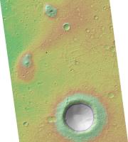
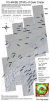
I wanted to visualize how the Gale Crater (msl study site) surface projects itself in terms of different sensors, as well as between the 10 adjacent HiRISE dtms listed on the map. A two-framed flashing movie http://www.flickr.com/photos/marsmojojojo/9540049251/ is an example of feature dislocation at the edge of the orthographic images. The map below projects those differences at 50-meter breaks spanning the 10 HiRISE dtm extent. The difference at the edges (featured in red) is most apparent in the Northern portion of the image. The hilly terrain to the south values are offset slightly compared to the Northern portion, but still visibly offset by some tens of meters in places. This offset affects the mosaic, and every model I run afterward, which is in conflict with my longing for order, especially in the overlapping regions of the map at larger extents. I have a couple ideas I may try but my mars time is slipping away rapidly to studies of a more earthly nature.... If anyone has experience geo-referencing or creating orthos I would greatly appreciate your comments.
|
Posted by: djellison Aug 22 2013, 07:19 PM
Any HiRISE DTM (and I assume HRSC DTM ) gets matched to the reference MOLA data. In same cases, there might only be one or two MOLA points within an entire DTM with which to do that.
The uncertainty of MOLA, the sparsity of its data compared to the HiRISE or HRSC footprint, the size of a MOLA footprint, and os on and so forth - this results in the differences between neigbouring DTMs.
It's a non-trivial task to remove those differences - one which I know some developers here on lab have tried to solve using a gradient domain solution that took several months.
Posted by: RoverDriver Aug 22 2013, 07:48 PM
RRussman, each DTM is ortho rectified an as such they are projected on a flat plane but each DTM is projected on a different plane so at the edges the planes exhibit the largest co-registration error. You would need to re-project all DTMs on a common plane but besides being non-trivial, the map you obtain is not really "ortho" anymore as you would have significant distortions. The other thing you could do is to project each DTM on the spheroid and then do a cylindrical projection. There's no good solution and what I do is to just work on one DTM at a time (currently still on PSP_010573_1755).
Paolo
Posted by: Phil Stooke Aug 22 2013, 07:48 PM
One lesson to take from this is that DEMs and associated orthophotos look beautiful but are not gospel. You have to treat them with a bit of suspicion.
Phil
Posted by: RRussman Aug 24 2013, 11:35 PM
Doug, Im pretty sure everything is matched to MOLA after 2000, but as you point out, the sampling is sparse even along track. By sparse I mean there are 48,211 mola points (PEDR) over several tracks/orbits in the map extent, and yes, some dtms are far more populated than others are. The HRSC and HiRise products are continuous data sets with much finer resolution. An excerpt from the literature on the resolution mismatch:
Because of the low horizontal resolution of the MOLA data set compared to HiRISE images, vertical accuracy will likely be governed by the difference between localized topographic features and the broader-scale relief as measured by the altimetry, and may be several meters. The resolution mismatch between the two data sets is likely to make direct use of MOLA for horizontal control almost impossible. Our approach is to control lower-resolution images to a shaded relief product generated from MOLA data gridded at 1/256 or 231 m/pixel, then to transfer control from these images to the high-resolution stereopair. (McKewen, etal, 2007) (fromhttp://onlinelibrary.wiley.com/doi/10.1029/2005JE002605/abstract, access required for full text)The discontinuity is most noticeable in the northern portion of the map with the DTEEC_010573_1755_010639_1755_U01 appearing offset more, relative to the adjacent overlapping regions, as well as the general flow of the collective model at multi-product extents. It might simply be that this model received less rigorous processing to the north and away from the msl region of interest.
Since editing is extremely time-consuming, it is usually done on easily corrected errors and in the areas of most interest to the researcher. (From the http://hirise.lpl.arizona.edu/dtm/about.php)
Paolo, I appreciate your suggestions and will experiment with re-projecting the dtms. I have experimented with re-geo-referencing the orthos (3rd order polynomial RMS:~0.7). The distortions were minimal, but as you mentioned, they lose their distinct relationship to the dtm and coordinate system, not to mention time consuming, tedious work. It makes your solution sound very appealing.
Phil, I am suspicious of every data set I open, especially my own
Powered by Invision Power Board (http://www.invisionboard.com)
© Invision Power Services (http://www.invisionpower.com)