Printable Version of Topic
Click here to view this topic in its original format
Unmanned Spaceflight.com _ Cometary and Asteroid Missions _ CE-2 flyby of Toutatis
Posted by: Paolo Aug 25 2012, 04:27 PM
I thought it was time to split the subject from the Moon forum.
Admins, can you move the relevant messages here?
anyway, just out: an interesting blog article by Bill Gray explaining how he recovered the probe and how he computed the orbit yielding the 13 December flyby date
http://www.planetary.org/blogs/20120825-change-2-the-full-story.html
Posted by: Paolo Aug 27 2012, 10:02 AM
a few more observations of Chang'e 2 (designated 2010-050A by the COSPAR) in solar orbit were made last saturday by the Catalina Sky Survey
http://www.minorplanetcenter.net/iau/DASO/000000/DASO_000449.txt
I hope Bill Gray will soon be using them to update its orbit determination and encounter estimates
Posted by: TheAnt Sep 1 2012, 10:03 PM
Interesting story thank you for sharing.
Mr Gray seem to be quite the detective and he do use the word 'sleuth' as well. =)
Posted by: rlorenz Sep 1 2012, 10:19 PM
I don't suppose they'll rename the spacecraft 'Obelix'....
Posted by: Paolo Oct 7 2012, 08:37 AM
I have got a copy of this paper presented at last week's IAF Congress
http://www.iafastro.net/iac/paper/id/15724/summary.lite/
I will not share the paper, but I can tell you something more about the Toutatis flyby
- first of all: 13 December 2012 is confirmed as the date. no distance nor relative speed or other details are given
- we are told that the Beijing Aerospace Control Center called for proposals on a mission beyond L2 in January 2012.
- there were lots of interesting proposals including one that would flyby Earth and Moon repeatedly, visit the L1 and L2 Lagrangian points, flyby a hundred-meter sized asteroid and finally explore the L4 Sun-Earth point in 2017 (the paper states that CE-2 would have been the first mission to do so. I think one of the two Stereos was first)
- in March 2012 the Toutatis flyby, proposed by the Chinese Academy of Space Technology was selected
- in a non-optimized form, the mission would have cost 107.5 m/s of the remaining 120 m/s delta-v budget
- a 6.2 m/s correction on 15 April "was mainly used to keep the Lissajous trajectory". it was previously reported as the date CE-2 was maneuvered out of the L2 halo orbit
- trajectory optimization was only carried out starting on 16 April. After optimization, an additional 22 m/s delta-v was gained that could be used to ensure a successful flyby
- the first targeting maneuver was carried out on 31 May (32.9 m/s)
- the second targeting maneuver (46.5 m/s) was to be carried out on 24 September
Posted by: tolis Oct 10 2012, 01:45 PM
According to JPL's HORIZONS ephemeris service,
(Some of) The vital statistics of Toutatis on the 13th December 2012 are as follows:
Epoch (UT) () Geocentric distance () Apparent Magnitude () Solar Elongation
() (AU) () () (deg)
13/12 00:00 () 0.0466 () 10.73 () 125
13/12 12:00 () 0.0471 () 10.65 () 128
14/12 00:00 () 0.0478 () 10.59 () 132
Toutatis will be east of the sun and so an evening object in the sky. Judging from the magnitude and
solar elongation, I would say that it is well within reach of backyard observers (including myself).
Regards to All,
Tolis.
Posted by: Paolo Oct 10 2012, 03:15 PM
I saw it in November 1996 using a small, 114 mm telescope. under dark skies, it was easy to spot and it was amazing to see it clearly glide against the background stars
Posted by: Paolo Oct 11 2012, 07:00 AM
today on arXiv: http://arxiv.org/abs/1210.2853
Posted by: tolis Oct 12 2012, 10:22 AM

It will be moving quite fast on this occasion too, about 1/3 degree per hour.
Posted by: Paolo Oct 28 2012, 08:43 AM
to answer Phil Stooke's question in another thread http://www.unmannedspaceflight.com/index.php?showtopic=6675&view=findpost&p=193809 about the CE-2 end of mission I noted playing with the http://www.projectpluto.com/pluto/mpecs/cheprobe.htm that the orbital period of the probe is now 1.044 years that is it will trail behind the Earth by 15 degrees every year. in four years that is in July 2016 it will pass close to the trailing Lagrangian point L5. It will then be back in the vicinity of Earth in 24 years.
I pointed this out to someone in China who worked on orbit design for the Toutatis flyby but he told me that this is a pure coincidence and that it was not done on purpose
BTW I posted this graph of the orbit of CE-2 up to the end of 2016 in a fixed Sun-Earth reference to the NASAspaceflight forum a few weeks ago. L5 is the red dot.
|
Posted by: Phil Stooke Oct 28 2012, 01:38 PM
Excellent - thanks for this.
Phil
Posted by: Tom Tamlyn Oct 28 2012, 03:49 PM
The link to Bill Gray's August 25 planetary.org article in post # 1 is broken.
I found the post at:
http://www.planetary.org/blogs/guest-blogs/20120825-change-2-the-full-story.html
Posted by: Paolo Dec 5 2012, 06:29 PM
just tweeted by @asrivkin at the AGU meeting
which to me confirms the difficulty of imaging Toutatis with a push-broom camera instead of a proper 2-dimensional CCD
Posted by: Phil Stooke Dec 5 2012, 07:10 PM
Check out this e-poster from the current AGU meeting:
http://fallmeeting.agu.org/2012/eposters/eposter/p31a-1873/
This is about radar imaging of Toutatis. Even if we only get a couple of reasonably well resolved images of Toutatis, it will be a big help in interpreting the radar images which contain complex ambiguities. There is a detailed shape model, but such models are also not without problems. Plus of course, there will be some information (we would hope) about albedo variations etc. which the radar does not give.
Phil
Posted by: Paolo Dec 5 2012, 07:20 PM
I saw it. It's a pity that 2 pics will not be enough to reveal the complex spin of Toutatis
Posted by: Phil Stooke Dec 5 2012, 07:51 PM
No, but radar does that very well.
Phil
Posted by: Paolo Dec 5 2012, 08:04 PM
speaking of which, the first radar image of the 2012 flyby
http://echo.jpl.nasa.gov/asteroids/Toutatis2012/Toutatis2012_planning.html
Posted by: Paolo Dec 6 2012, 08:15 AM
from this post to the mpml asteroids and comets group http://tech.groups.yahoo.com/group/mpml/message/27635 the two pics will be taken one on the inbound leg, the other on the outbound leg. my Chinese sources say the targeted distance will be 1000 km.
I guess what this means is that CE2 will aim at the point in space where Toutatis is supposed to be and wait for it to cross the field of view of its push-broom camera at the correct angular rate. then it will be reoriented to take a second picture with the same technique on the outbound leg
Posted by: machi Dec 6 2012, 10:58 AM
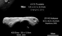
So we can expect images with resolution ~100 m/pix at best. This isn't much for such small body like Toutatis (~2.5 km diameter), but still it can be very interesting.
~25 image elements per diameter is enough for major units, like albedo regions or big craters and it's sufficient for Emily's size comparison poster.
Posted by: Explorer1 Dec 6 2012, 11:19 PM
So the images will be the equivalent of what Deep Space 1 did, assuming they pull them off?
Posted by: machi Dec 7 2012, 12:43 PM
Deep Space took images of Braille with resolution around 180 m/pix. Braille is two times smaller than Toutatis. So with some luck, we can expect images four times better than those of asteroid Braille (4× more pixels across diameter of asteroid).
This is what we can expect, if everything goes well and image will be taken close to 1000 km flyby distance.

Posted by: Paolo Dec 7 2012, 01:17 PM
anyway, as the camera has two linear CCDs, a forward looking and a rearward looking one I would rather expect two couples of pictures instead of two pictures
Posted by: Phil Stooke Dec 7 2012, 02:11 PM
Machi, that is Steins, not Braille.
And Paolo - doesn't that suggest the forward camera will take one and the rearward camera will take one? Otherwise you seem to be suggesting the spacecraft reorient itself during each sequence.
And there's another new image here:
http://echo.jpl.nasa.gov/asteroids/Toutatis2012/Toutatis2012_planning.html
Phil
Posted by: machi Dec 7 2012, 03:11 PM
Yes, I know.
That is image of Steins from Rosetta used for demonstration as Toutatis may appear from CE-2.
I thought that I wrote this clearly, if not my apologies, it was lost in translation.

In fact this image was uploaded with name "http://www.unmannedspaceflight.com/index.php?act=attach&type=post&id=29102", but evidently forum system still uses some kind of thumbnail with different name even for small images.
Posted by: Paolo Dec 7 2012, 07:56 PM
the camera has two parallel CCDs, one looking 8 degrees forward of the nadir (when in lunar orbit), the other 17.2 degrees to the rear. To me the most logical sequence would be one where Toutatis crosses the field of view of the first CCD almost perpendicular to it and then about one minute later (the exact timing depends on the encounter geometry, which is not known) that of the second sometime on the inbound leg. Around closest approach the probe is reoriented so that Toutatis crosses again both fields of views in the outbound leg. this gives two pairs of images.
If no reorienting is done, you get only one pair of images a few tens of seconds apart
Posted by: Paolo Dec 8 2012, 08:46 AM
third radar picture http://echo.jpl.nasa.gov/asteroids/Toutatis2012/Toutatis.dec4-7.p125us.p032Hz.s439.b.gif
it's amazing how the quality and resolution of these images has increased since 1992
Posted by: machi Dec 9 2012, 10:59 AM
According to this http://echo.jpl.nasa.gov/asteroids/Toutatis2012/Toutatis2012_planning.html, flyby distance will be around 300 km.
If it's true, then images from CE-2 will much better than in my simulated image (maybe 4× better).
Posted by: tasp Dec 9 2012, 01:21 PM
I'm not thinking of any other 'rocks' imaged with ground based radar getting a nice visible light camera flyby. (It is REALLY early for me though, and no coffee yet) (we need a 'sleepy' emoticon)
Anyone recall any others?
Posted by: Paolo Dec 9 2012, 01:23 PM
Itokawa had been imaged by radar before Hayabusa arrived
Posted by: machi Dec 9 2012, 02:34 PM
Anyone recall any others?
Not exactly "rock", but also http://www.planetary.org/blogs/emily-lakdawalla/2010/2742.html.
http://echo.jpl.nasa.gov/asteroids/Itokawa/ostro.etal.2004.itokawa.pdf is article about "Radar observations of asteroid 25143 Itokawa".
Posted by: Phil Stooke Dec 9 2012, 02:53 PM
Comparing the Itokawa radar images and shape model with the spacecraft images shows the limitations of using low resolution radar data. The basic size and elongation are well established but the two-lobe shape is not seen. For Hartley-2 two lobes are also resolved but not much more. But for Toutatis we have high resolution radar data and a detailed shape model, and nothing with that kind of radar data has been visited by a spacecraft. So this will be a very interesting encounter.
Phil
Posted by: JimOberg Dec 9 2012, 05:47 PM
Technical info is great. Hsieh hsieh.
Big picture question: has anybody received any word about the health of the spacecraft in the past two months?
We're only days from the encounter. Is the absence of any news from China something to worry about?
Posted by: Explorer1 Dec 9 2012, 08:38 PM
The absence of news is business as usual over there. Has there even been an official announcement of this flyby yet from CNSA in Beijing?
Posted by: JimOberg Dec 10 2012, 06:14 AM
I beg to differ. When things have been going well, China has released a stream of information, even ahead of actual events. They have been far more open then the Soviets were in Space Race days. I remember and can compare/contrast.
This silence is unusual.
Posted by: Explorer1 Dec 10 2012, 06:32 AM
Yes, I've read Don Mitchell's page on the old Soviet missions to the Moon and Venus, and the lengths he had to go to. I'm not sure if he posts on here, but I;m sure has has good insights too.
I'm just saying we should not get our hopes for a real crisp and immediate release like we've become used to from NASA or even ESA. I'd even be happy with a Halley's nucleus type blur.
Posted by: Paolo Dec 10 2012, 08:15 AM
there was a long article on the development of CE-2 on a Chinese site recently
http://zh.cnr.cn/2100zhfw/zhhz/201211/t20121114_511342196.shtml and http://zh.cnr.cn/2100zhfw/zhhz/201211/t20121114_511342196_1.shtml
at a certain point it is stated (my adaptation of a google translation):
Posted by: JimOberg Dec 10 2012, 03:13 PM
Thanks, Paolo, that's encouraging.
I also found this more recent URL but I can't get my translators to work:
http://news.e23.cn/content/2012-12-10/2012C1000084.html
Posted by: Paolo Dec 10 2012, 06:01 PM
another long article in Chinese linked today http://bbs.9ifly.cn/thread-9843-109-1.html
http://y234.cn/?p=6128
Posted by: JimOberg Dec 10 2012, 08:01 PM
I see a picture of chang'e-2 but can't get translator to work. Any help?
Posted by: stevesliva Dec 10 2012, 08:13 PM
^ http://translate.googleusercontent.com/translate_c?depth=1&ei=nUHGULCFK8ThiwKWvYCgAw&hl=en&prev=/search%3Fq%3Dhttp://y234.cn/%253Fp%253D6128%26hl%3Den%26safe%3Doff%26tbo%3Dd%26biw%3D1280%26bih%3D671&rurl=translate.google.com&sl=zh-CN&twu=1&u=http://y234.cn/%3Fp%3D6128&usg=ALkJrhg3uBTCy-6BG4knSQqLmQRkcNCDrw
... seems to be a blogger asking similar questions. It appears based on english articles, so you get what we already know translated to chinese and then google-translated back. Wouldn't assume that will do anything but subtract information.
Posted by: elakdawalla Dec 10 2012, 08:13 PM
Google translate worked for me. There's no new information in here -- in fact it links to Bill Gray's guest blog on planetary.org and to MPML. It provides background on Toutatis and on NEOs. Mostly it asks why the national space agency isn't ballyhooing this more, and then answers the question by explaining that Chang'E 2's ability to get good data on the encounter is limited, concluding that while any data will be interesting, the significance of this is more as an engineering test of the Chinese ability to make the encounter succeed, providing "valuable experience." Seems like a very nice explainer -- hopefully the author will get some traffic from Chinese readers
Posted by: JimOberg Dec 10 2012, 09:17 PM
thanks. i agree that the technology demonstration of the SEL2 dwell, and the departure to the toutatis intercept point, are awesome new levels of space navigation capabilities. it would be nice to get images but your own blog put that in perspective.
i'm working to get my own media clients to appreciate the accomplishment and not to set artificially high success criteria.
would clementine have faced the same problem with asteroid imaging, or was its survey camera of a different design?
Posted by: mcaplinger Dec 10 2012, 09:51 PM
The Clementine cameras were all framing cameras with filter wheels, so no.
That said, slewing a pushbroom imager is not that big a deal; see http://mars.jpl.nasa.gov/mgs/msss/camera/images/9_11_98_phobos_rel/ Of course I don't know how CE2's attitude control system works.
Posted by: Phil Stooke Dec 11 2012, 02:59 PM
http://echo.jpl.nasa.gov/asteroids/Toutatis2012/Toutatis2012_planning.html
New images appearing on this site now - one other difference between radar and CE2 images, worth remembering - the visible images will have MUCH better signal to noise - radar images are speckly and show very little detail near the terminator (except bits of it which are tilted towards the radar, like a crater rim) - in fact it's sometimes hard to see where the radar terminator is. So the new images really will be complementary in many ways.
Phil
Posted by: machi Dec 11 2012, 05:06 PM
Very interesting images. Here is image pair from 9. December in more "visible" look:
|
Posted by: Phil Stooke Dec 11 2012, 06:04 PM
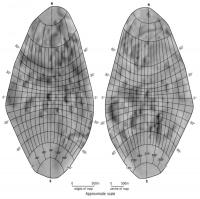
15 years ago I made a map of Toutatis, using an experimental image interpretation method. It was never published because of a dispute about the validity of the concept I had devised. This is the map, in case anybody is interested. Apart from the concept I used to convert the geometry of radar images to the equivalent of visible images for mapping (that's where the dispute came in) I also tended to push my interpretation of craters too far in those days. Every little hollow became a crater in my map. Now I would be more cautious in my interpretation. (Note - rotation is about the long axis - and because of ambiguity in the images, this might be a mirror image of the real surface)
Phil
|
Posted by: Paolo Dec 13 2012, 01:07 PM
anybody knows whether ESA is providing tracking support to CE-2?
otherwise, has anybody tried computing the windows of visibility for the Chinese Deep Space Network stations? just to know when we can expect to have some news of the flyby
Posted by: Greenish Dec 13 2012, 03:00 PM
The images at http://echo.jpl.nasa.gov/asteroids/Toutatis2012/Toutatis2012_planning.html get better every day. Will be really interesting to see how the delay-doppler representations compare to the visible light ones.
I just noticed the following on that page: "Scheduling update: due to an equipment failure, radar observations of Toutatis at Arecibo were cancelled." Not sure when this appeared... Can anyone explain what the potential impact could be on the observing campaign? Not that I'm complaining, the Goldstone quick results are great and impressive on their own.
Posted by: Phil Stooke Dec 14 2012, 03:57 PM
I don't see anything in the online chinese press yet.
Phil
Posted by: Paolo Dec 14 2012, 04:14 PM
I have seen a release (in Chinese) on the site of the Chinese Academy of Sciences.
I don't have a link at hand, but it really didn't say anything new.
Posted by: machi Dec 14 2012, 04:43 PM
I read on multiple Chinese pages, that they planned ~12 images of Toutatis.
But source is unknown, respectively it's some astronomer in Beijing.
EDIT:
http://translate.googleusercontent.com/translate_c?depth=1&hl=cs&rurl=translate.google.cz&sl=auto&tl=en&u=http://www.cas.cn/xw/kjsm/gndt/201212/t20121214_3707543.shtml&usg=ALkJrhhyxlz-d-eNOBeZqg0aBeqeASpatw is info from Chinese Academy of Sciences.
Posted by: Paolo Dec 14 2012, 05:46 PM
be sure to check this!
http://www.youtube.com/watch?v=waH9zfEbNJs
Posted by: Phil Stooke Dec 14 2012, 06:51 PM
The radar video is great - first time I have seen something like this, and it does a fantastic job of resolving the front-to-back ambiguity. In a still image you can often see two lobes appearing to intersect, but you can't tell which is in front and which behind.
Phil
Posted by: machi Dec 14 2012, 07:53 PM
The video is great, but Toutatis looks somewhat distorted.
On every image all sides are doubled, so it looks like two overlaid images of Toutatis:
|
Posted by: Phil Stooke Dec 14 2012, 08:05 PM
That's because of the bizarre geometry of radar images. Imagine looking out over a range of hills with peaks at varying distances. Now imagine they are semi-transparent so you can see hills behind other hills. At the radar limb in these images, that is what we are seeing. The geometry is totally different from visible images. But with many images the ambiguities can be resolved - which is what this is all about, and why the Chinese images will be really useful. We have never had both high resolution radar and (reasonable resolution) visible imaging for any object before.
Phil
Posted by: tedstryk Dec 14 2012, 09:04 PM
Assuming it is better than the 2002 NY40 images, this could be significant.
Posted by: yaohua2000 Dec 14 2012, 11:27 PM
Video: http://news.cntv.cn/china/20121215/100850.shtml
Relative speed at 10.73 km/s
Closest flyby at 3.2 km altitude
Sequence (local time):
• Dec13 15:25 Return solar panels to 180 degrees
• Dec13 15:30 Switch to inertial attitude control
• Dec13 15:45 Switch to star orientation 10
• Dec13 15:48 Switch to star orientation 2
• Dec13 16:20 Solar panel monitoring camera power up
• Dec13 16:30 Closest flyby
• Dec13 16:45 Solar panel monitoring camera power down
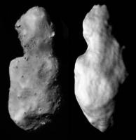
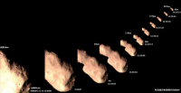
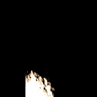
Attached image: captured at 93–240 km distance between 16:30:09–16:30:24, maximum resolution 10 meters/pixel

|
Posted by: Cosmic Penguin Dec 14 2012, 11:30 PM
Just in from the Chinese news TV reports an hour ago: the fly-by was a success! The closest fly-by was at 08:30:09 UTC on December 13 at an altitude of just 3.2 km and at a relative velocity of 10.73 km/s. Quite a few photos were snapped by the CCD camera - including this series of photos taken 93 - 240 km away from Toutatis:

Chinese news report about the fly-by (may translate it later if I have time): http://news.cntv.cn/china/20121215/100850.shtml
P.S. My first post here! (my interest in planetary exploration started in grade 1 after seeing photos from the twin Voyagers)
Posted by: tedstryk Dec 14 2012, 11:35 PM
Woah! That is better than I was expecting. Welcome to the interplanetary club, China!
Posted by: machi Dec 14 2012, 11:56 PM
Fantastic and great news!
Now we have another country in "discovery" class! Congratulations!
BTW, very nice surprise. Images are much better than expected.
Posted by: Explorer1 Dec 15 2012, 12:06 AM
Very fast release! I'm glad to have been wrong in my earlier speculation. I wonder how real/fake the color is.
Posted by: elakdawalla Dec 15 2012, 12:09 AM
I wonder, were these images taken with the webcam-style cameras they used to monitor deployments and rocket firings?
Posted by: Phil Stooke Dec 15 2012, 12:18 AM
3.2 km? Amazing, just amazing. Solar panel monitoring camera power up... I guess it was that one. Does this mean there's more to come from the main camera?
Phil
Posted by: mcaplinger Dec 15 2012, 12:28 AM
Can that be right? Navigationally I'd have thought getting that close was impossible without some kind of autonomous or at least very fast-turn optical navigation. Impressive if true.
Posted by: elakdawalla Dec 15 2012, 12:38 AM
I'm trying to figure out what the scale of the image is, with the endgame, of course, being the addition of this body to my asteroids-visited-by-spacecraft montage. A major question for an elongated body is: are we seeing its maximum dimension, or is it foreshortened?
From http://echo.jpl.nasa.gov/asteroids/4179_Toutatis/toutatis.html, the radar-derived dimensions of Toutatis:
"The asteroid's maximum extents along the principal axes are (1.92, 2.29, 4.60) +/- 0.10 km. "
Measuring on the photo, I get that the long axis here (which may not be the full length, if it's not broadside-on) is 792 pix
The short axis here should be somewhere in between the 1.92 and 2.29 axes, and it's 312 pix
That ratio is about 0.4, which is almost identical to 1.92/4.60
Which would mean that (assuming the JPL numbers are correct) we really are looking at it pretty close to broadside-on, with the plane of the sky being close to the plane of the minimum and maximum principal axes.
Somebody please check my work!!
Posted by: machi Dec 15 2012, 12:59 AM
My measurements are: long axis ~800 pix, short axis ~330 pix and ratio 0.4125.
Posted by: Phil Stooke Dec 15 2012, 01:06 AM
I can confirm that this view shows the long dimension, probably no more than a little bit foreshortened. I think it's pretty much being viewed along its shortest axis, so we are seeing the long and intermediate axes.
Phil
Posted by: Phil Stooke Dec 15 2012, 01:26 AM
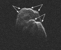
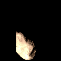
Bringing out a bit more detail in the brighter areas:
|
(Thanks, Chinese space agency, for these great pictures)
Phil
Posted by: machi Dec 15 2012, 01:46 AM
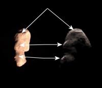
Attempted comparison with Goldstone radar imagery.
|
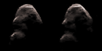
Posted by: ElkGroveDan Dec 15 2012, 02:37 AM
Is there any doubt that we are looking at two distinctly separate objects in contact?
Posted by: Phil Stooke Dec 15 2012, 02:47 AM
If this is an approach sequence, there may be a departure sequence as well.
Phil
Posted by: elakdawalla Dec 15 2012, 02:58 AM
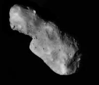
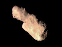
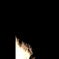
Beginning to look at the image and try some early (read: arm-waving) interpretation. Some things I notice: there are boulders that remind me of Itokawa. But they're sparse; it's substantially smoother than Itokawa. So I'd interpret that to mean it is mostly covered in a regolith. I also see circular depressions of a wide variety of sizes, the sort of thing one would tend to interpret as impact craters. Some have sharper edges than others. Of course, you have to be cautious; smaller ones especially might be collapse pits. I'm intrigued by the apparent roughness of the larger end. Again, though, I need to be careful; its apparent roughness could be due to lighting geometry. It's a pretty low-phase-angle image. Overall, it seems faceted. A slope map of this thing would be fascinating.
Posted by: yaohua2000 Dec 15 2012, 03:01 AM
More info: 20 Kbps at 7 million km, 90% data has been received so far.
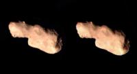
This is a television screenshot of a close-up image at 5 m/pixel, captured at 08:30:05, 47 km away. (Hope to have raw image soon)
|
Posted by: tedstryk Dec 15 2012, 03:07 AM
Thanks for posting that! I think you mean 5 m/pixel.
Posted by: Phil Stooke Dec 15 2012, 04:30 AM
Shape model and slope map here:
http://echo.jpl.nasa.gov/asteroids/4179_Toutatis/hires.pdf
Phil
Posted by: Paolo Dec 15 2012, 07:37 AM
wow! China releases the first pics and I happen to be sleeping?!? btw it's good to be proven wrong about the number of them!
Kudos to the Chinese!
EDIT: gotta love this! in the west we tend to compare asteroids to potatoes. someone on the 9ifly forum is comparing it... to a ginger root!
Posted by: Paolo Dec 15 2012, 08:32 AM
is this schema is to be believed http://english.cri.cn/mmsource/images/2012/12/15/9305c82a4f8c441bb172d8e4073c048f.jpg they were indeed all taken using the webcams (CMOS and not CCD cameras)
from 9ifly forum, this seems to mean that the solar panel that the webcam was designed to monitor was rotated out of the camera fov
Posted by: Doc Dec 15 2012, 09:08 AM
Outstanding Chinese performance. Thanks for posting the images so quickly! Really took my breath away
Posted by: Tayfun Öner Dec 15 2012, 09:30 AM
Here is a 3D PDF of the shape model. (It is heavily optimized to be under the 1MB attachment limit.)

Posted by: machi Dec 15 2012, 11:14 AM
http://news.cntv.cn/program/zdxwzx/20121215/102491.shtml dedicated to Toutatis flyby and ChangE program.
I recommend you last few minutes (from ~55:00), where you can see some shots from planned ChangE-3 mission.
As I understand from these pictures, they tried some imaging around closest flyby distance (~3.2 km) by different camera, so maybe we can expect even better images in future.
|

|
Posted by: Drkskywxlt Dec 15 2012, 11:58 AM
Congrats to the Chinese! There's some depressions that obviously look like craters there, but not as many as I'd expect and they seem "muted". Would this suggest a low-density "rubble pile" composition?
Posted by: Stefan Dec 15 2012, 11:58 AM
Phil
I wonder if this "approach sequence" is in fact a single image shown at different sizes.
Posted by: machi Dec 15 2012, 12:41 PM
Yes, all images are almost equal (apart from size), but this is exactly what one can expect, when spacecraft is flying in this kind of trajectory (fast and extremely close flyby). From a greater distance, it looks more like a fall.
Posted by: tolis Dec 15 2012, 02:07 PM
Amazing stuff!
Apart from the sheer speed of the flyby, I would imagine that Toutatis' extremely long rotation period
(~24hr) would contribute to it appearing the same - apart from a change of scale - in all images.
Also interesting is the relative absence of craters and the presence of boulders. In this sense, Toutatis seems to
be intermediate between larger asteroids (eg Eros) where you have both craters and boulders and Itokawa
where craters are virtually absent.
Posted by: Paolo Dec 15 2012, 02:12 PM
this is what a Chang'e 2 CMOS webcam looks like. and some treat from earlier in the mission
|
Posted by: Phil Stooke Dec 15 2012, 02:31 PM
Comparison of the new image with the radar shape from the paper I linked to above. I think the new image is tilted a bit, with the top end tilted perhaps 20 degrees toward the camera.
Phil
|
Posted by: Paolo Dec 16 2012, 09:53 AM
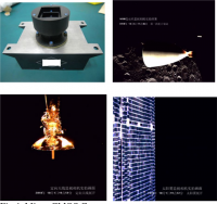
Chinese sources such as this http://www.stdaily.com/stdaily/content/2012-12/16/content_552959.htm acknowledge that the CMOS monitoring webcam has been used. the 200 g, 1024 x 1024 pixel camera apparently shot 5 pictures every second for more than 100 seconds around closest approach. The camera has a 7.2 degree fov.
I wonder whether any science camera picture was finally taken or not. from the timeline on the left of this picture http://i.dailymail.co.uk/i/pix/2012/12/15/article-0-16868F40000005DC-269_634x422.jpg which yaohua2000 translated here http://www.unmannedspaceflight.com/index.php?s=&showtopic=7433&view=findpost&p=195772 I think it was not even powered on.
Chinese sources also report that a domestic telescopic observation and orbit determination effort was carried out on Toutatis. This was not strictly needed for such a well known object, but was still an useful exercise for an encounter with a more obscure object.
Posted by: machi Dec 16 2012, 10:15 AM
I have somewhat different informations about ChangE-2 cameras.
According to this http://translate.googleusercontent.com/translate_c?depth=1&hl=cs&rurl=translate.google.cz&sl=auto&tl=en&u=http://wuxizazhi.cnki.net/Search/HFYG201102001.html&usg=ALkJrhi-cTauj7TZzZCq9fOyO573GkMmhA, CE-2 has four monitoring cameras (+ fifth camera - scientific stereo camera). Three cameras are designed to provide engineering monitoring of spacecraft (solar panel, engine, antenna) and one camera is used for moon imaging.
Moon imaging camera weights 502 g and has CMOS chip 1280×1024. Engineering cameras weights 352 g.
Posted by: Cosmic Penguin Dec 16 2012, 11:30 AM
Apparently the main camera was not powered on (nor it seems the other instruments on the spacecraft either), due to these reasons:
1. The data transfer from the main CCD camera would be very bad at such a long distance from Earth
2. The double linear-phase CCD camera has such a small FOV that it would not be able to take photos at such a relative speed during the fly-by
I might need to dig around the 1 hour special report on the Chinese news TV channel yesterday to look for other interesting facts on the fly-by.....
Oh and forget about another mission by CE-2, it has less than 10 m/s of delta-v capacity left....
Posted by: Paolo Dec 16 2012, 12:01 PM
I don't want to belittle the CE-2 achievement, but I have a question for the scientific data minded: beside basic shape and topography, what can be extracted from this kind of webcam-like, probably uncalibrated images? not much I suspect.
as for another extended mission, I think even merely tracking the probe as long as possible, without firing the engine anymore would provide useful experience for future missions beyond the Moon
Posted by: machi Dec 16 2012, 12:36 PM
We can look to the past. CE-2 flyby was in many ways similar to the NEAR flyby around Mathilde.
http://adsabs.harvard.edu/cgi-bin/nph-abs_connect?db_key=AST&db_key=PHY&db_key=PRE&qform=PHY&arxiv_sel=astro-ph&arxiv_sel=cond-mat&arxiv_sel=cs&arxiv_sel=gr-qc&arxiv_sel=hep-ex&arxiv_sel=hep-lat&arxiv_sel=hep-ph&arxiv_sel=hep-th&arxiv_sel=math&arxiv_sel=math-ph&arxiv_sel=nlin&arxiv_sel=nucl-ex&arxiv_sel=nucl-th&arxiv_sel=physics&arxiv_sel=quant-ph&arxiv_sel=q-bio&aut_logic=OR&author=&ned_query=YES&sim_query=YES&start_mon=01&start_year=1995&end_mon=01&end_year=2013&ttl_logic=OR&title=Mathilde&txt_logic=AND&text=&nr_to_return=200&start_nr=1&jou_pick=ALL&ref_stems=&data_and=ALL&group_and=ALL&start_entry_day=&start_entry_mon=&start_entry_year=&end_entry_day=&end_entry_mon=&end_entry_year=&min_score=&sort=SCORE&data_type=SHORT&aut_syn=YES&ttl_syn=YES&txt_syn=YES&aut_wt=1.0&ttl_wt=0.3&txt_wt=3.0&aut_wgt=YES&obj_wgt=YES&ttl_wgt=YES&txt_wgt=YES&ttl_sco=YES&txt_sco=YES&version=1 about Mathilde and NEAR.
CE-2 engineering cameras are not scientific instruments, but it's better than nothing and images from those cameras can be useful for shape determination, topography (as you said), geology (cratering record, boulders), rudimentary photometry etc.
Another thing: Flyby was very close, so it's maybe possible to refine mass measurements of Toutatis and with better shape model, we can better derive its density and models of internal composition as well.
Posted by: tedstryk Dec 16 2012, 01:22 PM
It may also provide a bridge between what we are seeing in radar imaged asteroids vs what we are seeing with from spacecraft flybys.
Posted by: Phil Stooke Dec 16 2012, 03:24 PM
"beside basic shape and topography, what can be extracted from this kind of webcam-like, probably uncalibrated images? not much I suspect."
Basic shape and topography tell us a lot - geological history, surface age from crater counts, redistribution of regolith by downslope processes, existence or not of 'ponds' as on Eros or smooth plains areas on Itokawa, hints of internal structure such as fractures or rubble-pile structure. The literature on small bodies extracts a great deal from images like these. Even without the big scanning camera, the close images from the smaller camera(s) will give us great details for many kinds of analysis.
Phil
Posted by: mcaplinger Dec 16 2012, 04:29 PM
What does "webcam-like" mean? A camera is a camera. These images might be a bit blurry, but they're a lot better IMHO than the science camera's on, for example, Deep Space 1. Most use of panchromatic or relatively broadband color imaging is morphologic and has little to do with calibration. As often as not, calibration is more about removing objectionable image signature, not data analysis, and these images look pretty good. I'm impressed, and even more so by the close flyby distance.
Posted by: dilo Dec 16 2012, 10:15 PM
I tried to make a stereogram using the fourth and last (biggest) image in the https://planetary.s3.amazonaws.com/assets/images/9-small-bodies/2012/20121214_toutatis_change2_multi-pic_slide.jpg?__utma=113505944.694187299.1351254349.1355673579.1355685211.12&__utmb=113505944.0.10.1355685211&__utmc=113505944&__utmx=-&__utmz=113505944.1355649729.10.4.utmcsr=google|utmccn=%28organic%29|utmcmd=organic|utmctr=%28not%20provided%29&__utmv=-&__utmk=265550031:
|
Not sure about the result, however... if a parallax does exist, it is very small indeed!
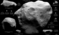
PS: I just updated asteroids/comets poster:
|
Posted by: tasp Dec 17 2012, 04:40 AM
Appreciate the stereogram effort very much. I think the compression noise in the images is what's giving me a headache, but underneath the noise, there does seem to be some appropriate depth in the image. For me, the upper right crater like depression seems appropriately bowled out, and the divot at the right end looks gougy enough. Let's hope some better feedstock turns up, or maybe some more massaging of the image can alleviate the compression artifacts.
Posted by: Paolo Dec 17 2012, 09:39 AM
thanks everyone. as I said, I didn't mean to belittle the achievement, I was merely trying to get an idea of what could be extracted (beside ooohs and wows) from images by a camera not meant for science.
according to JPL experts it may even be possible to get some info on the mass of Toutatis from tracking data. http://www.skyandtelescope.com/news/home/Toutatis-Revealed-by-Chinese-Spacecraft-183673171.html
Posted by: JimOberg Dec 17 2012, 01:57 PM
My thinking exactly. I don't know any interplanetary nav team in the solar system who would AIM at such a fly-by with a required error of +/- 2 km. Is it possible that the aim point was much farther out and this is just an accidental close pass?
Posted by: JimOberg Dec 17 2012, 02:05 PM
Tracking to determine the exact course change from the close fly-by will give superb data on asteroid mass. With images that show volume, you get real density data. Accidental or not, the very close fly-by itself is a major scientific experiment.
Posted by: JimOberg Dec 17 2012, 02:09 PM
On a policy issue note, we must realize that China kept this encounter secret -- even the date -- with the intent, arguably, to cover up any failure. Not revealing it until almost 48 hours after fly-by is a very discouraging retreat to 'Space Race' soviet-style secrecy. Glory and kudos to the spacecraft operators, for sure -- and more to come. Shame on the government information managers.
Posted by: ElkGroveDan Dec 17 2012, 02:12 PM
Thanks dilo that demonstrates nicely how the size fits in the gap between Itokowa and Eros. It's interesting that the surface features as someone pointed out above, appear to be transitional; somewhat like Itokowa, but with hints of characteristics of larger bodies.
Now if we could come up with a popular-press unit of measure. Too big to measure in "battleships" like Itokowa, not big enough to measure in "manhattans" like Eros. Can someone think of a well known, elongated island 2.5 to 3 miles long?
|
Posted by: ngunn Dec 17 2012, 03:28 PM
Venice?

|
Posted by: Phil Stooke Dec 17 2012, 03:31 PM
"China kept this encounter secret -- even the date -- with the intent, arguably, to cover up any failure. "
Jim, post #5 at the start of this thread suggests to me that China did not keep anything secret.
Phil
Posted by: JimOberg Dec 17 2012, 04:09 PM
Jim, post #5 at the start of this thread suggests to me that China did not keep anything secret.
Phil
Good point, and I'd seen that paper -- so was puzzled by total lack of run-up and real-time coverage of the encounter.
To modify my complaint: despite disclosure to the space science community of the planned intercept date [a fact independently discovered and published by foreign astronomers], there was no Chinese media attention to the progress of the mission for months leading up to, and days AFTER, the encounter.
I'm still dismayed by that behavior. And to discourage it happening again, I urge those who share my dismay to pass it on to their Chinese contacts.
It really was out of character of recent Chinese public information release policies, which have been satisfyingly candid and open, even about future plans and actions. We had gotten accustomed to an open publicity policy. Seeing this one exception to it startled me.
Posted by: Paolo Dec 17 2012, 06:21 PM
apparently, they aimed a point 15 km from the asteroid (its center of mass, I think). ephemeris uncertainties of the two objects probably summed (in the worse possible direction) to yield 3.2 km (I don't know whether this is measured relative to the surface or center of mass. in the former case, it would translate in a miss distance from the center of mass of some 5 to 6 km)
Posted by: JimOberg Dec 17 2012, 08:06 PM
Source, please?
Posted by: machi Dec 17 2012, 08:41 PM
http://www.stdaily.com/stdaily/content/2012-12/16/content_552959.htm, I suppose.
Posted by: JimOberg Dec 17 2012, 10:05 PM
You've picked a language I can't handle, please translate the relevant portion. Hsieh hsieh ni.
Posted by: tedstryk Dec 17 2012, 10:28 PM
http://www.stdaily.com/stdaily/content/2012-12/16/content_552959.htm I know the Google translation is rough, but it is what most of us non-Chinese speakers are using. Not clear as to why you couldn't do this.
Zhou Jianliang said: "through the precise measurement and control, we can control the distance between the Chang-e II and Tutadisi asteroid if they collided, the impact of the asteroid is small but we should not have caused it any impact. "he said, need to take pictures on the Tutadisi" Chang E on the 2nd design orbit is to make them as close as possible without collision. Our current monitoring and control capability, the minimum distance if they rendezvous designed for 15 km, the collision probability is less than one ten-millionth.
According to reports, Chang E II with Tutadisi asteroid rendezvous when the distance is only 3.2 km.
Posted by: JimOberg Dec 18 2012, 04:00 PM
Thanks! Since the article mentions the actual 3.2 km fly-by, does this mean it was published AFTER the actual fly-by -- or is it dated before the encounter?
ADMIN - Jim, UMSF is a place for discussion and collaboration. It's not a short order grill where you can show up at the counter and make demands. That is exactly how your previous three posts have come across. You have the same resources available to you through the Internet that the rest of us have. Investigate it yourself and let us all know.
Posted by: JimOberg Dec 18 2012, 05:06 PM
Unnecessary quoting removed
Acknowledged and agreed!
Posted by: jgoldader Dec 18 2012, 05:40 PM
The success of this flyby makes one wish for a few spacecraft stationed at one of the Earth-Moon Lagrange points that we could dispatch, with sufficient notice, for flyby inspections of other closely approaching NEOs. A visual camera and perhaps a near-IR imager with well-chosen filters or an imaging near-IR spectrometer, maybe even a magnetometer, would make for a nice payload. I suspect that in some cases, navigation strategies might exist that could eventually return the spacecraft back to the Lagrange point for additional encounter opportunities.
Jeff
Posted by: dvandorn Dec 18 2012, 07:01 PM
Good concept. However, since you'd have a wide variety of approach trajectories for these various NEOs, any such on-demand intercept spacecraft would likely need to start out its mission with an awful lot of delta-V available in its fuel reserves. With enough energy packed into the fuel tanks, and with possibly a small fleet of such interceptors, you could use some to perform high-delta-V intercepts once or twice in their lifetimes, and others to perform low-delta-V intercepts many times.
Not only would this be a good way to collect data on the various NEOs that pass through the neighborhood, it would be really good operational experience for deploying a small fleet of interceptors whose purpose is last-minute trajectory deflection on objects that are spotted late and could impact Earth. We obviously don't have good or proven strategies for last-minute deflection technology at the present time, of course... but by the time we decide what measures would be effective, we would have a lot of good operational experience at deploying on-demand spacecraft to intercept approaching objects.
-the other Doug
Posted by: elakdawalla Dec 18 2012, 07:20 PM
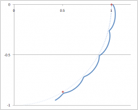
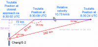
Michael Khan from ESA has done a little trigonometry using the distance information on that graphic and came up with the head-scratching result that, assuming the distance and time information on the graphic is correct, Chang'E 2 passed the asteroid at 59 kilometers:
|
The other thing that has me a little puzzled is that the images on the multi-view montage must not all be shown at their original pixel scale; the range to the target decreases by only a little more than half, yet the apparent size enlarges by more than a factor of 10. Examining them closely, the smallest image looks fairly clean, while the largest one has artifacts that suggest it's been enlarged.
Posted by: machi Dec 18 2012, 09:08 PM
I did some calculations based on two highest resolution images (47 km/16:30:05, 93 km/16:30:09) and resulting distance is anywhere between 0 - 33 km. Time for closest approach is 16:30:00-01. Errors are caused by inaccuracies in time information.
It looks that some informations are definitely incorrect. Because we have evidently images with 5 and 10 meters resolution, I think that 240 km and 16:30:24 are wrong informations.
Another possibility is that flyby distance wasn't 3.2 km, but 32 km. 32 km can be result in all calculations (based on informations 47 km/16:30:05, 93 km/16:30:09, 240 km/16:30:24).
Posted by: mcaplinger Dec 18 2012, 09:21 PM
Isn't this just the same image replicated at different sizes, as was pointed out earlier?
If it was a full sequence, one would expect to see a big change in phase angle from inbound to outbound since the geometry changes rapidly around C/A.
[Unless the whole image sequence was taken a fair time out from C/A, which doesn't make a lot of sense. Still don't know what the camera FOV or IFOV was or how the spacecraft was pointed during the fyby. Was it just inertially fixed?]
Posted by: Phil Stooke Dec 18 2012, 09:51 PM
The illustration might just be an 'artist's impression' of the approach, not the actual image sequence. We don't really know what audience it was intended for. It might not support too much analysis.
Phil
Posted by: machi Dec 18 2012, 10:21 PM
If flyby distance was really 3.2 km, then changes in phase angle were minimal even few seconds after flyby .
I did simple graphic with two images, for which we know (?) distance. For comparison I've added 240 km distance.
If Paolo is right, then FOV is 7.2° and camera has 1024×1024 CMOS detector (or maybe 1280×1024). This roughly corresponds to published resolution 10m/93 km, 5m/47 km.
|
|
Posted by: elakdawalla Dec 18 2012, 10:47 PM
http://www.stdaily.com/stdaily/content/2012-12/16/content_552959.htm discusses the camera's resolution as follows (in Google translation, but it seems a pretty straightforward discussion of the relationship between range and resolution):
That fits with the smallest image in the multi-image view, which is about 60 pixels long at a reported range of 240 km.
Mike, I agree I don't see any rotation from one image to the next, but I do see more detail in the largest image than could possibly have arisen from enlargement of the smallest one. I think there's at least two images here but I don't know how many more than that. In the discussion leading up to the flyby I'd heard that the plan was to take only two images!
Posted by: mcaplinger Dec 19 2012, 01:23 AM
True, but the small one could be a shrink of the large one.
Seems like there are two images in machi's last post, but I'm not sure where they came from -- video grabs?
Still

Posted by: elakdawalla Dec 19 2012, 01:39 AM
For now, is just about the most informed comment I can make, too.
A thought: would anyone who is a more skilled image processor than I like to take a crack at a rigorous approach to determining whether we can tell if we're looking at multiple copies of the same image, or at different images? Are we even sure that the rumored 47km one (of which we only have a screen grab from a webcast, as far as I know) shows anything distinctly different from the ones in the multi-image montage?
Posted by: Phil Stooke Dec 19 2012, 03:26 AM
I took the smallest image and blew it up to the size of the largest, pasted it over the largest and flipped between them (as layers in Photoshop). There seemed to be a real sense of a small amount of rotation - really a change in view direction, not rotation of the asteroid. I can't post it as an animated GIF (maybe someone else can) but it looked real to me.
Phil
Posted by: elakdawalla Dec 19 2012, 04:29 AM
Thank you. Since I have a history of "seeing" parallax in image pairs that don't have it, I didn't trust my own examination.
Posted by: Stefan Dec 19 2012, 07:55 PM
Somehow I am reminded of the time of the Huygens landing, when somebody posted an anaglyph of two identical DISR images on the web, and people claimed to see depth...
Posted by: Paolo Dec 19 2012, 08:41 PM
the translation of an interview on the Chinese-led international effort to refine the orbit of Toutatis, using telescopes in China, Hawaii and Chile
http://translate.googleusercontent.com/translate_c?depth=1&hl=en&rurl=translate.google.com&sl=auto&tl=en&twu=1&u=http://news.cqnews.net/html/2012-12/19/content_22661107.htm&usg=ALkJrhjItKC_DMxHq5pfEayz1jbqoh7j2g
I was wondering whether optical navigation was ever carried out by CE-2 before the encounter. I don't think any of the cameras was suited for this. the webcams were probably not sensitive enough to spot Toutatis more than a few hours before the encounter, and the science camera had its well known limitations
Posted by: Paolo Dec 22 2012, 09:09 AM
I was able to get a copy of this paper, which I will not redistribute. it's in Chinese, but you also have a table with the camera characteristics that is quite understandable.
for pixel count, the "landing" and engine monitoring cameras are 1280 x 1024, while the two other cams are 1024 x 1024. they are all 8-bit, color cameras.
the solar panel monitoring camera is just 358 grams in mass and consumes 2.45 W.
what the paper lacks is a table giving the field of view of each camera. in the case of the engine monitoring one it is stated in the text to be 40 degree wide, while the antenna monitoring camera seems to be a 139 degree fisheye, if I understand correctly the google translation.
there is a picture of each camera, and the solar panel monitoring one looks slightly different from the others for its longish optics, probably some kind of narrow angle lens (which would make sense for its use in the Toutatis encounter)
Posted by: Phil Stooke Dec 23 2012, 03:58 AM
I am surprised that an optical astronomy campaign would have been needed to refine the orbit of Toutatis. I would have thought that the radar data collected over the last two decades would have made it one of the best known orbits of any asteroid.
Phil
Posted by: Paolo Dec 23 2012, 08:38 AM
I don't think it was strictly needed either. after all, the ephemeris of Toutatis in JPL's Horizon have uncertainties of the order of several kilometers, which is notable for an asteroid. plus, it's not through optical astrometry that you are going to get a more precise orbital determination.
my feeling is that the Chinese wanted to demonstrate the full process that would normally be needed for an asteroid mission. I have seen lists of alternative flyby candidates for CE-2 and they are all smallish, unnumbered objects for which an optical astrometry campaign would have been necessary.
Posted by: Paolo Dec 23 2012, 10:26 AM
just found a paper (marked "for academic exchange only") that gives some technical overview of the asteroid flyby target selection
http://www.docin.com/p-413770925.html
Posted by: Paolo Jan 3 2013, 08:35 PM
I am a bit surprised and disappointed that neither Science nor Nature (nor Aviation Week) have said a single word on the flyby in their latest issues...
Posted by: JimOberg Jan 8 2013, 05:25 AM
I agree. Three weeks have passed and not another peep about the success in the Chinese news media. This is very odd.
Posted by: Phil Stooke Jan 8 2013, 08:22 PM
SBAG meeting:
http://www.lpi.usra.edu/sbag/meetings/jan2013/agenda.shtml
9:3010:15 a.m. Chang'e 2 flyby of Toutatis (Han Li, Chinese Academy of Sciences)
This is where we can expect something useful.
Phil
Posted by: Paolo Jan 15 2013, 08:16 PM
I couldn't see the presentation on webex (I was at work at the time) and I have seen only a few details of it on twitter and facebook. anybody knows more?
Posted by: Phil Stooke Jan 18 2013, 11:39 PM
http://www.lpi.usra.edu/sbag/meetings/jan2013/presentations/sbag8_presentations/TUES_0930_CE_Toutatis.pdf
!
Phil
Posted by: Paolo Jan 19 2013, 09:24 AM
the repositioning of the solar panels reported http://www.unmannedspaceflight.com/index.php?s=&showtopic=7433&view=findpost&p=195772 makes even more sense: they had the solar panels covering part of the field of view and they ensured that they would be seeing the dark side of them.
it would be great to have the video embedded in that presentation...
Posted by: Liss Jan 19 2013, 10:12 AM
That's interesting:
(1) Revised flyby timeline, shifted some 5 seconds against the 15 Dec images;
(2) Authors claim to calculate distances from asteroid size, not from times;
(3) Yet again time intervals between images are too small to fit the pairs of distances.
Posted by: Paolo Jan 19 2013, 10:14 AM
and here is the image sequence. the complete sequence should include something more than a hundred images resolving Toutatis
|
Posted by: Paolo Jan 20 2013, 09:43 AM
Daniel Fischer (cosmos4u on twitter) has publishedhttps://www.facebook.com/photo.php?fbid=4617215903329&set=a.4145962122279.2148279.1080556720&type=1 of the distances and times in the prez. they seem to make quite some sense
Posted by: machi Jan 20 2013, 12:36 PM
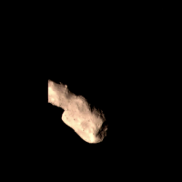
This is composite image from last four published images (with highest resolution).
Resolution is ~4.5 m/pix.
|
Posted by: tasp Jan 20 2013, 03:16 PM
Thanx for the composite image!
The 'divot' (lower right) is even more interesting at this resolution; the grooves, or scratchesif you will, are parallel to each other and to the sides.
Posted by: Decepticon Jan 21 2013, 12:41 AM
Excellent work!
Posted by: Paolo Jan 22 2013, 05:54 PM
I got a copy of the video that was embedded in the SBAG presentation from the author (hint: her address is on the first slide)
I will not redistribute it, but here are some of the frames. note that the quality and compression seem a lot better than we have seen until now

|
|
|
|
|

|
Posted by: Paolo Mar 2 2013, 10:07 AM
that paper has now been published in a proper peer-reviewed journal:
http://ams.cstam.org.cn/EN/Y2013/V29/I1/123#
Posted by: Paolo Apr 28 2013, 12:56 PM
papers to be presented at the Beijing IAF congress in September:
http://www.iafastro.net/iac/paper/id/16780/summary.lite/
http://www.iafastro.net/iac/paper/id/17795/summary.lite/
Posted by: Paolo Jun 8 2013, 01:01 PM
the latest issue (5 2013) of SCIENCE CHINA Technological Sciences http://tech.scichina.com:8082/sciE/CN/volumn/current.shtml has a bunch of papers (in Chinese) on the CE-2 flyby of Toutatis.
nothing yet on the English version of the journal http://tech.scichina.com:8082/sciEe/EN/volumn/current.shtml
Posted by: Phil Stooke Jun 8 2013, 01:11 PM
The first one is a summary of the CE2 mission with some Moon images. Two more on the trajectory, navigation etc., but not actually anything on the Toutatis observations yet. Unless I missed something.
Phil
Posted by: Paolo Jun 8 2013, 01:16 PM
you are right.
one of the papers (the one on page 478) seem to describe how they determined the flyby distance from the monitoring camera images
Posted by: Paolo Jun 19 2013, 05:18 AM
still more papers in the 8 June issue of the journal
tech.scichina.com:8082/sciE/CN/volumn/volumn_6667.shtml
from a quick look, they seem to be mostly engineering papers
Posted by: Explorer1 Nov 21 2013, 08:19 PM
Closest approach was apparently less than a kilometer from the surface, according to this new post! :0
http://www.planetary.org/blogs/emily-lakdawalla/2013/11211107-imaging-results-from-change2-toutatis.html
Talk about good aim, and Toutatis's slow rotation! Hats off to the Chang'E navigators!
Posted by: Paolo Nov 22 2013, 06:22 AM
one of the papers at this year's IAC had a closest distance of 1,564 +/- 10 m. from the center of mass, I think
Posted by: ElkGroveDan Nov 22 2013, 03:11 PM
http://www.planetary.org/blogs/emily-lakdawalla/2013/11211107-imaging-results-from-change2-toutatis.html
Be careful, you can't believe everything you read on the internet.
Posted by: elakdawalla Nov 22 2013, 03:51 PM
That's pretty amazing considering the long axis is 4.5 km.

Posted by: Paolo Nov 22 2013, 05:31 PM
I checked the paper "http://www.iafastro.net/iac/paper/id/16780/summary.lite/" and it states:
so they are indeed not determining the distance from the surface. and later they conclude
note also that the paper by Huang et al referenced by the Icarus paper is this one: http://tech.scichina.com:8082/sciE/CN/abstract/abstract511202.shtml
Posted by: Paolo Nov 22 2013, 05:33 PM
by the way, Huang et al. (page 600) state, google translated:
Distance from the geometric center of the overflight time: 1.32 km ± 120 m;
Posted by: elakdawalla Nov 22 2013, 06:36 PM
Thanks very much for digging those up! I will add those details into my blog post.
Posted by: Paolo Dec 12 2013, 05:47 PM
another (open access, this time) paper on the scientific results of the flyby
http://www.nature.com/srep/2013/131212/srep03411/full/srep03411.html
Posted by: Dysgraphyk Dec 13 2013, 04:58 PM
according to this paper
quite a close shave...

Posted by: Paolo Dec 13 2013, 05:04 PM
it still surprises me that they seem to have done it entirely without optical navigation. they just knew the exact orbit of the asteroid thanks to radar tracking and that of the probe thanks to ranging and they managed to pull out the closest flyby ever with these data
Posted by: ElkGroveDan Dec 14 2013, 12:58 AM
There probably was some serendipity involved.
Posted by: Paolo Dec 14 2013, 08:41 AM
actually, they had a trajectory correction (and a sizeable one, 3.3 m/s) the day before the flyby, so I guess they were aiming for a very close encounter on purpose
Posted by: Paolo Apr 10 2014, 05:28 PM
a paper on the future orbit of CE-2, due for publication in the Chinese Science Bulletin: http://www.docin.com/p-650957694.html
Posted by: Paolo May 29 2014, 08:07 AM
this interesting paper on the imaging strategy of CE-2 at Toutatis (which was also discussed on UMSF) has been published in Chinese Astronomy and Astrophysics: http://www.sciencedirect.com/science/article/pii/S0275106214000289.
the English version is unfortunately behind the paywall (but I have tried to contact the author to have a copy), while the Chinese version is available http://www.pmo.cas.cn/xscbw/twxb/xbll/2013_54/2013_54_5/201310/P020131008659666504848.pdf.
Posted by: Paolo Oct 25 2014, 06:34 AM
this was just published online in Advances in Space Research (and, incredibly for Elsevier, seems to be in open access): http://www.sciencedirect.com/science/article/pii/S0273117714006334
from a first, quick look, lots of interesting infos not published elsewhere:
- a detailed timeline of the corrections maneuvers leading to the flyby
- the targeted flyby distance was approx. 30 km but CE-2 ended being much closer (less than 2 km) to Toutatis
- distant images of the Earth and Moon were taken after departure, on 31 July and 1 August 2012. apparently, these were taken to test the camera (the CMOS monitoring camera used during the flyby, I suspect). it would be nice to see these images...
Powered by Invision Power Board (http://www.invisionboard.com)
© Invision Power Services (http://www.invisionpower.com)