Printable Version of Topic
Click here to view this topic in its original format
Unmanned Spaceflight.com _ Cassini's ongoing mission and raw images _ Enceladus August 11, 2008 encounter
Posted by: Floyd Aug 3 2008, 06:54 PM
Just 8 days until the next Enceladus encounter.
CICLOPS Rev 80 Looking Ahead will appear http://ciclops.org/news/looking_ahead.phpsoon.
Cassini Enceladus 080EN Mission Description is http://saturn.jpl.nasa.gov/multimedia/products/mission_descriptions.cfmnow.
We get to fly through the south polar jets again.
-Floyd
[edit] Soon = somtime before encounter 
Posted by: ElkGroveDan Aug 3 2008, 07:28 PM
Yikes they are really going to be diving trough those ice plumes. Makes me wonder if a post encounter view of Saturn might look something like this:
|
Posted by: jmknapp Aug 3 2008, 11:20 PM

I just made an animation of the encounter (60MB MPG file, right-click on image below to download):
http://cboh.org/~jmk/enceladus_aug2008a.mpg
It's from the point of view if the ISS narrow-angle camera, using pointing & position info from the SPICE kernels--pretty frenetic panning around at times! For a lot of the approach the camera looks to be pointing out into space--maybe towards where the plumes are located?
Posted by: nprev Aug 4 2008, 12:35 AM
Let me be the first to say both "OOO!!!" and "AHHH!"....damn cool!!!!
Doug will probably dislike your chosen background music, but he'll get over it...  Really beautiful work, man; absolutely inspiring. Thank you for sharing it with us!
Posted by: jasedm Aug 4 2008, 09:15 AM
Joe that's an inspirational piece of work! - many thanks for sharing it with us.
Am I right in concluding that the sequence planners may have allowed for some saturnshine exposures on the outbound leg?
I think the camera pointing into space is a consequence of other instruments being 'prime' during the very closest approach, in order to get other data on the plumes themselves.
Can't wait for the results on this one.
Posted by: jmknapp Aug 4 2008, 11:16 AM
My pleasure... and thanks to Cassini for timely updating of the ftp://naif.jpl.nasa.gov/pub/naif/, allowing such looks into the future.
I think the camera pointing into space is a consequence of other instruments being 'prime' during the very closest approach, in order to get other data on the plumes themselves.
Can't wait for the results on this one.
Don't know about specific plans. The team does publish such info sometimes in their "science plan" SPICE files, but the current plan, S42, ends on August 11 (hours before the Enceladus flyby
 ) and the next plan, S43, hasn't been posted yet. Usually there's a several day gap between the end of one plan and the posting of the next.
Maybe the links Floyd gave in the first post will tell some more, when updated.
Posted by: ynyralmaen Aug 4 2008, 11:56 AM
That may well be true, but I suspect it may also be related to the rapid motion of Enceladus across the sky as seen from Cassini during such a low altitude encounter... the spacecraft can't turn quickly enough to track the surface during the entire encounter, so before closest approach, the attitude is set ready to image the south pole, with the remote sensing instruments pointing north. The south pole is then in the field of view as soon as possible, yielding the highest resolution images.
Posted by: ilbasso Aug 4 2008, 12:27 PM
I imagine they also want to avoid exposing the camera to a high-speed encounter with particles in the plumes.
Posted by: tallbear Aug 4 2008, 06:02 PM
Enceladus is in eclipse from 224-21:42 to 225-00:08 --- T
Posted by: jmknapp Aug 5 2008, 01:36 PM
Note to self: figure out how to model eclipses sometime. Saturn's oblateness makes it even harder than otherwise.
Posted by: Decepticon Aug 5 2008, 04:32 PM
Is there any chance for Saturn Shine imaging during this encounter?
Posted by: volcanopele Aug 5 2008, 07:08 PM
There is some chance. But keep in mind that the sub-solar point is pretty close to the sub-Saturn point during the encounter, so areas illuminated by Saturn would also be illuminated by the Sun.
During the eclipse, well, you'd be seeing the same areas we would be seeing immediately before the eclipse starts, at good resolution, in sunlight.
Posted by: Floyd Aug 6 2008, 12:00 AM
Link to map of http://planetary.org/image/enceladus_flyby_map.pngon Emily's What's up in the solar system for week of http://www.planetary.org/blog/article/00001587/
Posted by: jmknapp Aug 6 2008, 12:35 AM
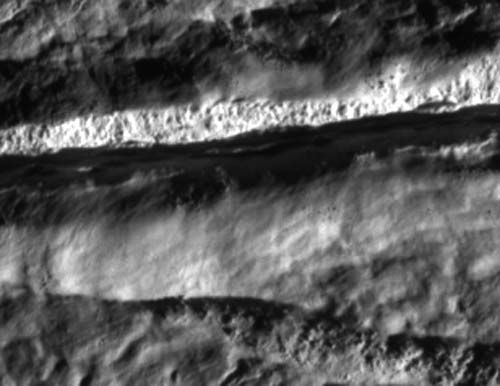
Looking at the planned ISS pointing during the encounter in more detail, it looks like there is a long dwell time on the Cairo tiger stripe, vent 'E':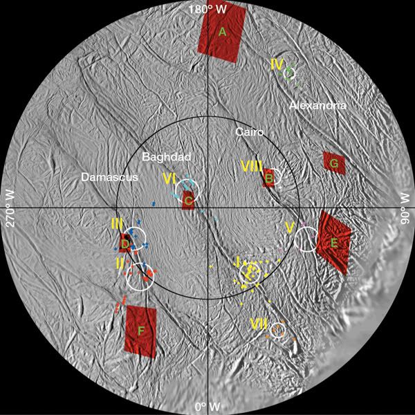
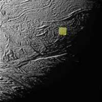
Any particular reason to concentrate on that one? One interesting thing is that it's exactly on the day/night terminator at the time of the observation (the green square shows the NAC view):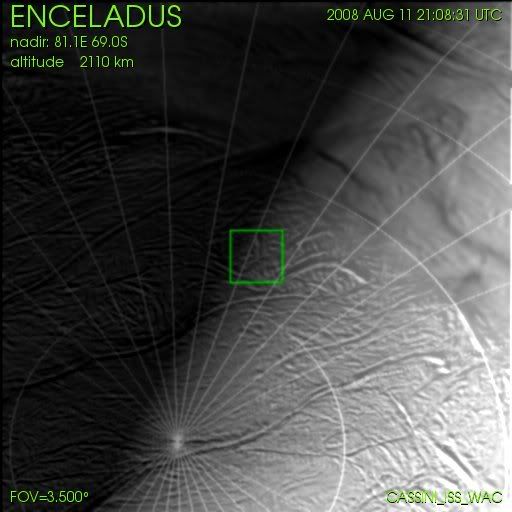
Posted by: nprev Aug 6 2008, 01:07 AM
Might've answered your own question in your post. Bet they're looking for some high-phase optical plume pics.
Posted by: jasedm Aug 6 2008, 10:27 AM
That would be very cool - this is high speed flyby (compared to most for Cassini) so lots of trade-offs at C/A, but perhaps there will be an attempt to take a number of images over cairo vent 'E', to enable the construction of a crude movie of the plume - similar to that achieved by Voyager 2 at Triton.
It would make sense to concentrate on the day/night terminator, as the plume would show up better against the nightside.
Posted by: jmknapp Aug 6 2008, 04:57 PM
Here's another animation, a much less frenetic, real-time view of the first four minutes or so after closest approach:
http://cboh.org/~jmk/enceladusRT.mpg
It starts just before closest approach with the ISS cameras pointing out into space (almost due north). The cameras fixate on the Cairo tiger stripe (vent E) for quite a while. This is only the first four minutes--looks like there's about a half-hour of ISS time possible before the eclipse.
Posted by: Floyd Aug 6 2008, 08:29 PM
The Mission Description is up. http://saturn.jpl.nasa.gov/multimedia/products/mission_descriptions.cfm
http://saturn.jpl.nasa.gov/multimedia/products/pdfs/20080811_enceladus_mission_description.pdf http://saturn.jpl.nasa.gov/multimedia/products/pdfs/20080811_enceladus_mission_description.pdf
Posted by: Holder of the Two Leashes Aug 6 2008, 10:04 PM
My appetite is whetted. Big time.
Posted by: Juramike Aug 6 2008, 11:01 PM
That was beautiful! Thank you for making those!
Posted by: Floyd Aug 6 2008, 11:19 PM
Joe, Really great animation!
Posted by: Juramike Aug 7 2008, 04:13 PM
CICLOPS description is now up (with a really nice detailed explanation of the camera pointing sequences): http://ciclops.org/view/5156/Enceladus_Rev_80_Flyby
Posted by: belleraphon1 Aug 7 2008, 04:24 PM
Wow!!!! This is going to be some encounter!!!!
Craig
Posted by: ugordan Aug 7 2008, 04:32 PM
A detailed description indeed. Reminds me of the (still definitive) Iapetus imaging sequence plan by Tilmann Denk.
Posted by: jmknapp Aug 7 2008, 04:40 PM
Wow... fantastic detail in the description!
I like the comment at the end from Carolyn Porco: "Prepare to be amazed!"
Posted by: nprev Aug 8 2008, 02:06 AM
Unfortunately, it's too much to hope for a few bugs on the windshield as well...
Not to stray too far OT here, but I really wonder how much material a future Enceladus plume sampling instrument could accumulate doing flybys like this. Perhaps Cassini is testing the water...? (yeah...go ahead & shoot me for that, it's deserved.)
Posted by: stevesliva Aug 8 2008, 03:17 AM
They're blogging the encounter here:
http://blogs.nasa.gov/cm/blog/cassini-aug08/
And there's a pretty sweet encounter video there...
Posted by: Holder of the Two Leashes Aug 8 2008, 04:00 AM
It is a good encounter video, and informative, but I find our own "less frenetic" simulation compliments this new (and official) one pretty well. I like them both.
There has been a lot to look forward to on this mission, but I rate this encounter among my personal big three. First there was the anticipation of the first aerial and surface pictures of Titan from Huygens, and they didn't disappoint. Then there was waiting for the first shots from the Iapetus flyby. Needless to say, well worth the wait.
Now we await the best photos we will see from this mission of the tiger stripe active vents. We will see ...
Posted by: jasedm Aug 8 2008, 11:28 AM
Wonderful. This has to be the best flyby yet in terms of availability to the public of instrument plans, sequences and computer simulations of the encounter.
It's very obvious the amount of work and close-scrutiny that has gone into the spacecraft attitude, trajectory, and pointing so that every conceivable opportunity for measurements with all of the instruments can be achieved.
It looks like Cassini will be operating at the absolute limits of its capabilities with regard to screwing as much science as possible out of the flyby - I'm particularly interested to see what comes out of what's being referred to as the 'skeet-shoot' images - it seems very experimental seat-of-the-pants stuff.
I'd be surprised if any spacecraft to date has executed a more complicated list of commands during such a short near-encounter timescale.
Can't wait.
Posted by: jmknapp Aug 8 2008, 01:37 PM
Sounds like an impressively complicated and exacting maneuver to get Cassini's rotation to just cancel out Enc's apparent motion during the skeet shoot.
From the description, looks like they're taking just one photo at each of the skeet shoot locations--so no closeup "movies" of plumes? What are the odds the plumes would even be visible, looking down on them?
Hypothetically, anyone know what the typical shutter times are for the ISS cameras in this kind of lighting, also the minimum cycle time in "burst mode"?
Posted by: ugordan Aug 8 2008, 02:01 PM
As I understood it, Cassini's rotation won't be able to cancel out Enceladus' motion at all. They'll spin the spacecraft as fast as possible and wait for the moon to overtake the camera FOVs. This will at least lower the motion smear somewhat.
I'm very, very skeptical any plume will be visible at roughly a 90deg phase angle, looking down on sunlit (albeit terminator) area. I don't believe that's even the goal.
You can pretty much forget about any "movies" from such a close range. The C/A part of the encounter is practically gone within a minute and the fastest the ISS camera can take frames is IIRC every 20 seconds, and that's using at least 2x2 binning, possibly lossy compression as well and probably the fastest telemetry pickup rate available to the instruments (in other words, it's the only instrument producing significant quantities of data - this probably also excludes "BOTSIM" ISS mode).
Shutter times for the WAC can be a few ms only, I think NAC needs at least 20-ish ms (thin air figure) for good S/N ratio at 90deg phase icy terrain illumination.
Posted by: jmknapp Aug 8 2008, 02:43 PM
I was going by this quote:
"A special spacecraft maneuver implemented for this flyby first points Cassini's ORS platform ahead of Enceladus while the spacecraft is spun at its fastest speed in the direction that Enceladus moves across the sky. When Enceladus' apparent motion eventually overtakes the spacecraft spin and passes in front of the ISS cameras, the relative motion of the camera boresight across the surface of Enceladus will be briefly matched well enough so that the ISS NAC will be able to obtain seven very high resolution snapshots of selected geological features."
So call it "briefly matched well enough."
Thanks for the info on camera specs.
Here's yet another animation, concentrating on the ISS pointing for the half-hour or so after closest approach, ending just before the eclipse:
http://cboh.org/~jmk/enceladus_iss2.mpg
That one runs at about 10x real-time (compared to 90x for the first animation).
Posted by: volcanopele Aug 8 2008, 02:47 PM
The skeet shooting images will be full-frame images, actually. Exposure times are on the order of 15-35 ms, though I have seen lower for the NAC.
Posted by: Holder of the Two Leashes Aug 8 2008, 03:00 PM
Speculation here: might we see a plume shadow, similar to the martian dust devil shadows we see in pics from mars orbiters?
Posted by: ugordan Aug 8 2008, 03:05 PM
I don't believe a shadow can/will be visible, the plumes are much more subtle than martian dust devils are and the low exposures will likely add a bit of noise to the images as well. The fact the plumes are only visible at high phase angles means they don't intercept much light in the first place. What is intercepted is mainly scattered, otherwise the plumes would appear dark.
Also, keep in mind the solar illumination will be coming in at a low angle so topography will be very pronounced, it would be much harder to spot shadows on that than a smooth martian surface.
Posted by: jmknapp Aug 8 2008, 03:12 PM
How about plume material that might be up in the sunlight, but silhouetted against the night side?
Posted by: ugordan Aug 8 2008, 03:19 PM
That would be potentially visible in an ideal situation, but again, there are two problems: the phase angle is still too low and scattered light off the sunlit surface might swamp out any signal from the plumes. I don't think I've ever seen a clear sign of the plumes at a 90 deg phase angle in distant Enceladus imagery.
It'd be nice to be wrong on this, though!
Posted by: elakdawalla Aug 8 2008, 03:30 PM
Here's some more good stuff on the WAC part of the closest-approach imaging, from Anne Verbiscer, who wrote the looking ahead feature on the ciclops site:
Neato

--Emily
Posted by: ugordan Aug 8 2008, 03:43 PM
So there's a wide-angle shot over the limb while no sunlit terrain is visible? If any image shows the plumes, it will be that one! I can't wait!
Posted by: Anne Verbiscer Aug 8 2008, 05:30 PM
Sorry, ugordan, it's a WAC over the terminator, not limb. After ring-plane-crossing in 2009, the plumes will still be sunlit while the surface will be in darkness, providing just the opportunity you describe for ideal plume imaging.
Posted by: jasedm Aug 8 2008, 06:00 PM
Good to see the interest that this flyby has garnered - guess we'll all have to wait and see
My vote for close-up plume shots/movies would be the later (equatorial flybys) - back-scattered light on the outbound leg perhaps.....
Posted by: Stu Aug 8 2008, 07:56 PM
For a change this is pretty good timing for us Brits... Anyone wanting to stay up late to follow the fly-by will be able (weather permitting) to catch one of the year's best meteor showers too.
The Perseid meteor shower is due to peak at 06.00BST on the morning of August 12th, so anyone staying up late the previous evening will - again, weather permitting - see more shooting stars than usual, and by the time the sky brightens early a.m. next morning we might be getting some Enceladus images, maybe? So, my timetable looks like it's set... finish work at 10, online by 10.20 to follow the fly-by here, go outside around 11.30 to watch the meteor shower, back inside at around 04.00 and check how the fly-by went, head off to bed 6ish... Hmmm, I like the sound of that plan.
Posted by: volcanopele Aug 8 2008, 09:08 PM
I got 0530 UTC for images to show up on the JPL Raw images page.
Posted by: Stu Aug 8 2008, 09:21 PM
Thanks VP, appreciate that tip. Looks like bed at 7 instead of 6 then

Posted by: Anne Verbiscer Aug 8 2008, 11:48 PM
For those interested primarily in the close approach imaging (including the Skeet Shoot), that playback won't start until nearly 1800 UTC on 12 August.
Posted by: scalbers Aug 9 2008, 07:24 PM
http://cboh.org/~jmk/enceladus_iss2.mpg
That one runs at about 10x real-time (compared to 90x for the first animation).
Very nicely done animation - I enjoyed listening to the accompanying Gayne Ballet Suite.
Posted by: jmknapp Aug 10 2008, 01:53 AM
YouTube has the clip from 2001: A Space Odyssey:
http://www.youtube.com/watch?v=anjVjj4w5rA
Posted by: Floyd Aug 10 2008, 02:06 PM
Nice atlas and map of Enceladus posted a few days back, in case you missed the link on the Latest from Saturn Multimedia Images page.
http://saturn.jpl.nasa.gov/multimedia/images/image-details.cfm?imageID=3173 http://saturn.jpl.nasa.gov/multimedia/images/image-details.cfm?imageID=3166
Posted by: Doc Aug 10 2008, 02:11 PM
I plan to make a mosaic or 2 from the coming data. In the meantime can anyone please direct me to information concerning the optics of ISS. Particularly on the focal length, etc.
Posted by: Roby72 Aug 10 2008, 06:36 PM
I remember one Cassini image with the NA camera which showed a slightly smeared surface of Enceladus. Many icy blocks were visible along the scarred surface. It was presented as the highest resolution image of that moon. Further I remember that it was 2x2 binned and a WA image was taken along (BOTSIM mode).
Can anyone check which resolution this NA image was ? It should taken in 2005.
It would be interesting to compare it with the best NA images of tomorows flyby.
Robert
Posted by: scalbers Aug 10 2008, 06:46 PM
On the CICLOPS page it says 4m/pixel, though with some blurring it might be about 8m resolution.
http://www.ciclops.org/view/1250/Boulder_Strewn_Surface?js=1
Posted by: Holder of the Two Leashes Aug 10 2008, 06:50 PM
You will find those two on Emily's blog site, where she has posted all the Enceladus pictures from Cassini flybys.
Here is the http://planetary.org/data/cassini/enceladus_011.html
They are near the bottom, under caption ISS_011EN_ICYEXO001_UVIS
These pictures were taken under less challenging conditions than this flyby, with a lower relative speed.
The distance to target was between 500 to 600 km.
Edit: They were taken from a range to target of 319 km, while Cassini was at an altitude of 208 km above Enceladus. The resolution of the NAC was 4 meters/pixel, with a little smear.
Posted by: elakdawalla Aug 10 2008, 07:21 PM
Yeah, those super-close images weren't originally on my page, because for some reason in Bjorn's database a bunch of the geometric data, including the range to target, was missing for that observation. (The range is what I use for the select query to get the best images.) Thanks to Holder for pointing out they were missing. I just went and checked the headers of the files and found that the geometric information is there, and it's different from what shows up on the Cassini raws website. My page has been re-updated with the geometric information. The resolution is about 5.5 meters per pixel after 2x2 binning, but there's also significant motion blur. I'm guessing the difference in the numbers may have to do with there being some slant angle to the Cassini observation, which isn't important if you're far from your target but if you're this close it means the range is longer than the range to nadir.
--Emily
Posted by: Anne Verbiscer Aug 10 2008, 08:38 PM
Doc, the definitive guide to ISS is found in Porco et al.'s 2004 article in Space Science Reviews. The following site includes a link to a .pdf version of the paper: http://ciclops.org/sci/reports.php#ISS
Posted by: jmknapp Aug 10 2008, 09:17 PM
When they say x meters/pixel, is that the average resolution in the image? Maximum? Minimum? Particularly if the boresight is off-nadir, there could be appreciable differences within the image.
Posted by: ugordan Aug 10 2008, 09:22 PM
I'd say they quote the resolution at the middle of the image. The NAC FOV is sufficiently small that resolution won't vary much except for very oblique angles.
Posted by: Stu Aug 10 2008, 09:31 PM
I know, I know, here I go again, laying on weepy, over-sentimental "Little House On The Prairie" feelings and emotions with a trowel, giving another robot tree-huggy feelings...
THROUGH THE PLUMES
What strange, warm-water wonderland will lie beneath me
as I fly high overhead?
Below me, rushing past a snow-globe scene,
a fractured, cratered wintry plain of gleaming
ice as hard as stone, criss-crossed with groaning
fissures that open and close like the bone-
dry maws of some fearful buried beasts
that feed on vacuum, and scream in pain
each time they feel Great Saturns pull
Peering down upon the gravity-sculpted ground
Ill feel a million Terran eyes upon me,
wondering what wonders I will see
when I fly into bright sunlight once again:
miles-high plumes of tinkling, twinkling vapour
shining bright against the endless night
of space? Racing through them might my face feel
the gentle touch of Enceladean dust?
Tomorrow I will know, and as snow falls softly
on the moon below I watch it grow and grow and grow
© Stuart Atkinson 2008
Posted by: belleraphon1 Aug 10 2008, 10:53 PM
[quote name='Stu' date='Aug 10 2008, 05:31 PM' post='123231']
I know, I know, here I go again, laying on weepy, over-sentimental "Little House On The Prairie" feelings and emotions with a trowel, giving another robot tree-huggy feelings...
Stu.. you just keep on being weepy robot tree-huggy.... plenty a folks can quote the facts....
not many can give us the feel.
Craig
Posted by: nprev Aug 10 2008, 11:01 PM
Hear, hear!!! UMSF's Poet Laureate has a job to do, which he does exceedingly well: documenting the unprecedented drama and beauty implicit in humanity's exploration of the Solar System. We can't be there ourselves; he takes us there. Well done, sir!
Posted by: jmknapp Aug 11 2008, 12:33 AM
Take for example the case cited above:
"They were taken from a range to target of 319 km, while Cassini was at an altitude of 208 km above Enceladus. The resolution of the NAC was 4 meters/pixel, with a little smear."
The camera is http://ciclops.org/sci/docs/CassiniImagingScience.pdf at 5.99 urad/pixel, so at a range of 319 km, wouldn't the resolution be 319000*5.99e-6 = 1.9 m/pixel (assuming a nadir shot)?
As for "the bone-dry maws of some fearful buried beasts that feed on vacuum," Cassini can only tell them "say cheese."
Posted by: ElkGroveDan Aug 11 2008, 12:44 AM
That's one of your best Stu.
I can almost picture Christmas carolers out for a sleigh ride on the snows of Enceladus.
Posted by: belleraphon1 Aug 11 2008, 12:48 AM
Hmmmmmmmmmmmmmm...
"fissures that open and close like the bone-dry maws of some fearful buried beasts that feed on vacuum, and scream in pain" I hope they do not scream "Tekeli-li! Tekeli-li!" Just joking... Stu... I get the same feel as you but am not talented enough to express it.
What marvel's will we eventually find there? What wonders lie under those portals to subterranian seas?
A spelunkers dream (or nitemare).
Craig ... a Lovecraft fan
Posted by: Bjorn Jonsson Aug 11 2008, 01:16 AM
In some cases geometric data is missing from the LBL and index files for super-close images for some reason. I've seen it happen for some of the Enceladus flybys, including (if memory serves) the very close nontargeted flyby in February 2005, some of the later targeted flybys and also the very close nontargeted Tethys flyby.
Does anyone know if the ultra-close images to be obtained during the upcoming flyby are BOTSIMs? This is not mentioned in the flyby descriptions I've read (I haven't checked everything yet though).
In any case this seems to me to be the most complicated Cassini flyby so far and one of the most exciting and interesting ones as well - good luck to everyone involved.
Posted by: ugordan Aug 11 2008, 01:27 AM
Yep, but that image was binned 2x2 so the effective pixel scale is 2*1.9 m/pixel, exactly as advertised.
Posted by: volcanopele Aug 11 2008, 01:42 AM
Only the last skeet shot image shown in the attached image from the http://ciclops.org/view/5156/Enceladus_Rev_80_Flyby contains a CL1/CL2 BOTSIM. There is a botsim at the start of that trigger, but it is over the nightside.
|
Posted by: ugordan Aug 11 2008, 01:49 AM
The reason there aren't more BOTSIMs might lie in what I wrote about earlier - they're twice as data intensive so might limit the speed at which ISS can take images, which in a high speed flyby is most undesirable. This is due to the fact the SSR recorders and their support system (what was it - the CDS?) can handle up to 384 kbps (I think). It doesn't physically prevent snapping a new picture, but the ISS generated packet buffer is emptied slower into the SSR if both cameras are generating much data and new images have to be "queued" until the buffer is emptied.
As a matter of fact, it's not unusual for CCD frames to have a delayed readout (there's a PDS image flag by that name) if the telemetry pickup is slower than the speed the camera reads out lines from the CCD and encodes them. This messes the dark current calculation as the rest of the image just sits on the CCD for a period of time and one can actually see higher dark currents starting at a certain line in some WAC raw images if you really brighten them.
But, I digress...
Posted by: jmknapp Aug 11 2008, 01:55 AM
Ah, I missed that earlier comment.
Using NAIF data to figure the ground speed of the ISS boresight during this flyby, I get this graph:
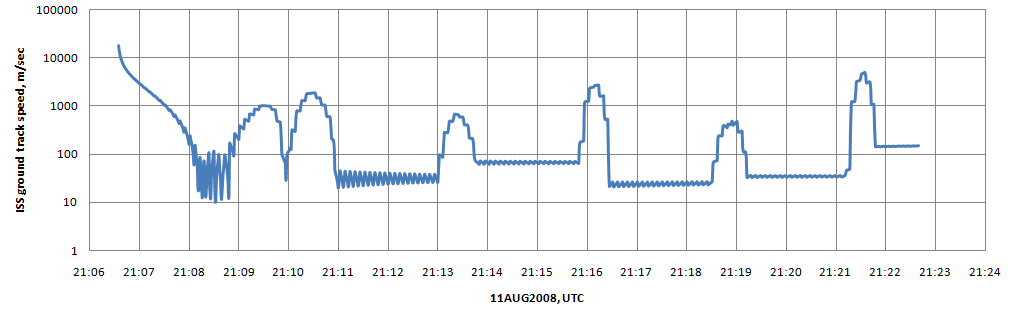
The "skeet shoot" is over around 21:11:09, then the 8-tile mosaic starts (not all of the latter shown).
Posted by: mchan Aug 11 2008, 05:40 AM
Well, Bob Shaw, who hasn't posted in over a year, would appreciate that. As do I.
(The images of the myriad of dark circular storm centers in Saturn's southern atmosphere remind me of the eyes of the Shoggoths.)
Posted by: dmuller Aug 11 2008, 11:21 AM
Better late than never, I have copied http://www.planetary.org/news/2008/0808_Cassini_to_Shoot_Past_Enceladus_for_Its.html into http://www.dmuller.net/realtime/index.php?mission=cassini
Posted by: Bjorn Jonsson Aug 11 2008, 08:10 PM
The distant (~450,000 km) images from today's 3 hour "early" downlink seem to be do down. At a quick glance I didn't notice any plume material but the automatic contrast stretch messes things up so this may not mean anything.
NAC image with Enceladus nicely centered:
http://saturn.jpl.nasa.gov/multimedia/images/raw/raw-images-details.cfm?feiImageID=165786
Scanning around somewhere near Enceladus:
http://saturn.jpl.nasa.gov/multimedia/images/raw/raw-images-details.cfm?feiImageID=165828
Posted by: ugordan Aug 11 2008, 08:29 PM
Wouldn't it be kind of weird seeing the south pole plumes while looking down onto the north pole?
Posted by: elakdawalla Aug 11 2008, 08:32 PM
I agree with you that it seems weird to be looking for plumes when you're looking down on the north pole, but that observation is described in the mission description as "Inbound Enceladus plume observations (distant)".
--Emily
Posted by: Bjorn Jonsson Aug 11 2008, 08:45 PM
The plumes are big so they should be there poking above the nightside limb. They may not be conspicuous here due to the viewing/lighting geometry (brightest part behind the limb, phase angle not high enough etc.).
Posted by: ugordan Aug 11 2008, 08:48 PM
They probably *are* poking behind, but at that point they're very faint and diluted. I wouldn't expect to see them even in calibrated imagery, a simple sunlit sliver is enough scattered light to drown out anything near.
Posted by: jmknapp Aug 11 2008, 09:51 PM
The first image--a WAC image at 21:07:19--will be framed something like this:
From the Verbiscer writeup:
Looks like some material from that fissure could easily be up in the sunlight but silhouetted against the night side? I think from the NAIF data the angle of the shot is something like 40 degrees from the local vertical.
Posted by: remcook Aug 12 2008, 08:34 AM
lots of blank white images of Enceladus in the raws...I wonder what's the cause of those.
Posted by: jmknapp Aug 12 2008, 10:53 AM
http://www.jpl.nasa.gov/news/news.cfm?release=2008-157:
Cassini's signal was picked up by the Deep Space Network station in Canberra, Australia, and relayed to the Cassini mission control at NASA's Jet Propulsion Laboratory in Pasadena, Calif.
"We are happy to report that Cassini's begun sending data home," said Julie Webster, Cassini team chief at JPL. "The downlink will continue through the night and into tomorrow morning.
Posted by: tedstryk Aug 12 2008, 01:57 PM
Someone on Enceladus was having fun pointing a laser pointer in Cassini's camera! 
Posted by: Floyd Aug 12 2008, 03:51 PM
If i'm reading the timeline from the Mission Description page correctly, the images we have are from the first (3 hr)downlink (pre encounter). The second (5 hr) downlink should have reached the ground a few hours ago. The third (9 hr) downlink is currently in progress and should finish about 7 hours after the time of this post. Hopefully there are a bunch of images on the completed second downlink which they will post soon.
-Floyd
Posted by: volcanopele Aug 12 2008, 03:54 PM
No images from the second downlink that I can see. I'm sure they will all show up in the 9 hour downlink (which actually starts up in a little under 1 hour).
Posted by: jasedm Aug 12 2008, 04:15 PM
See post 45 above - looks like it will be tomorrow morning before the very close shots appear (but we may get the Northern hemisphere shots prior to that )
Posted by: volcanopele Aug 12 2008, 04:19 PM
I know that My point was that the "we may get northern hemisphere images earlier" idea looks to not be correct. But it will just carry over to this next playback.
Posted by: ugordan Aug 12 2008, 04:23 PM
Why tomorrow morning? Anne Verbiscer said 1800 UTC today. Which is in a little less than two hours.
Posted by: volcanopele Aug 12 2008, 04:30 PM
Not sure where 1800 UTC came from. The 9 hour long playback hasn't started yet (20 minutes to go!). The images from that playback will show up on the JPL raw images page and the CICLOPS page at 0530 UTC (or thereabouts, that's the earliest) Tomorrow. No images other than the 2.5 km/pixel distant "plume tendril" observations are available at the moment.
Posted by: ugordan Aug 12 2008, 04:39 PM
I guess the ISS playback wasn't scheduled to start until about an hour into that 9 hr long playback or something.
How come there'll be such a long delay for the raws? Typically they show up as soon as they get down, you can sometimes actually catch the raw page being updated every minute with new images.
Posted by: volcanopele Aug 12 2008, 04:50 PM
The images on the raw images page shows up 4 hours after the playback ends. That isn't part of the real-time stream.
Posted by: Mariner9 Aug 12 2008, 05:28 PM
We are all getting spoiled. Remember how agonizingly slow it was waiting for Galileo images to get downloaded (at around 3 images per day)? Worse than that, during the first few orbits they were saved up until a press conference announcing the latest discoveries.
But at least you could eventually get to all of the images on the web, as opposed to the old days of Voyager where only a subset were published in magazines or books.
So.... much as I really, really, really want to see the closeups of Enceladus, I guess I'll just have to wait another 24 hours or so.
Posted by: peter59 Aug 12 2008, 07:26 PM
Que sera ? Big disappointment or images like this artist's painting :
http://saturn.jpl.nasa.gov/multimedia/images/image-details.cfm?imageID=3039
Posted by: vmcgregor Aug 12 2008, 07:27 PM
Approach images are now going to the raw image page. More will be coming!
Posted by: ugordan Aug 12 2008, 07:34 PM
Yay! I was hoping they'd pull something like this to cut down the wait for the public. Looks like outbound images at that, I thought we'd be seeing the inbound imagery first as that was scheduled to be downloaded first.
Posted by: jmknapp Aug 12 2008, 07:36 PM
Hey, those are receding shots, e.g.:
http://saturn.jpl.nasa.gov/multimedia/images/raw/raw-images-details165836.html
"N00118300.jpg was taken on August 12, 2008 and received on Earth August 12, 2008. The camera was pointing toward ENCELADUS at approximately 202,865 kilometers away..."
Is the science advisor being briefed? 
Posted by: Juramike Aug 12 2008, 07:39 PM
Camera still works! (*whew*)
Posted by: ugordan Aug 12 2008, 07:40 PM
Looks like no bugs on the windshield, too!
Posted by: Holder of the Two Leashes Aug 12 2008, 07:44 PM
They got the subject in the frame (fingers crossed)!
Posted by: elakdawalla Aug 12 2008, 08:03 PM
Some inbound shots there now...
Posted by: Paolo Amoroso Aug 12 2008, 08:33 PM
What do pictures like http://saturn.jpl.nasa.gov/multimedia/images/raw/raw-images-details165824.html show? Plumes?
Paolo Amoroso
Posted by: jmknapp Aug 12 2008, 08:38 PM
Yep, a couple from 109,000 km out. Actually almost all the money shots will be outbound, past closest approach. Should be a couple more inbound at around 40,000 km though.
Posted by: ugordan Aug 12 2008, 08:39 PM
Paolo:
Stray light, most likely from Enceladus itself. This is the reason I'm skeptical any plumes can be seen while sunlit terrain is actually in the frame, be they silhouetted against the blackness of space or not. The plumes are very tenuous.
Posted by: vmcgregor Aug 12 2008, 09:25 PM
The team is working to manually post a few of the images that are in the raw image cue. We know you're all waiting.. patiently..
Posted by: elakdawalla Aug 12 2008, 09:27 PM
There are a few more up -- looks like they are not the skeet-shoot, they are frames from the post-CA multispectral mosaic...
http://saturn.jpl.nasa.gov/multimedia/images/raw/raw-images-details.cfm?feiImageID=165845
http://saturn.jpl.nasa.gov/multimedia/images/raw/raw-images-details.cfm?feiImageID=165847
http://saturn.jpl.nasa.gov/multimedia/images/raw/raw-images-details.cfm?feiImageID=165848
http://saturn.jpl.nasa.gov/multimedia/images/raw/raw-images-details.cfm?feiImageID=165849
--Emily
Posted by: ugordan Aug 12 2008, 09:33 PM
Veronica, be sure to to send our sincerest thank you to the team folks for going that extra mile when they really aren't obliged to! Amateur enthusiasts do appreciate gestures like that.
Posted by: Roby72 Aug 12 2008, 09:36 PM
one image more:
http://saturn.jpl.nasa.gov/multimedia/images/raw/casJPGFullS43/N00118314.jpg
Robert
Posted by: Holder of the Two Leashes Aug 12 2008, 09:39 PM
Your efforts are much appreciated. Thank you.
Posted by: Roby72 Aug 12 2008, 09:47 PM
a saturnshine image ?
http://saturn.jpl.nasa.gov/multimedia/images/raw/casJPGFullS43/N00118315.jpg
Posted by: elakdawalla Aug 12 2008, 09:48 PM
Couple of eclipse photos up there now...
http://saturn.jpl.nasa.gov/multimedia/images/raw/raw-images-details.cfm?feiImageID=165851
http://saturn.jpl.nasa.gov/multimedia/images/raw/raw-images-details.cfm?feiImageID=165852
A general plea to folks: if you are going to link to images, please link to the HTML pages and not the JPG image files. That way we can see useful information like the filter choices and the range to the target. If you have questions, having that information makes it much easier to answer.
In response to your question, Roby72, those were taken in eclipse. It won't be Saturnshine, since Enceladus is in Saturn's shadow. We're seeing ringshine, and Anne Verbiscer said that Titanshine would also play a role.
--Emily
Posted by: belleraphon1 Aug 12 2008, 09:48 PM
Greatly. greatly, greatly appreciated.
New vistas on new worlds.... wow.
Craig
Posted by: jmknapp Aug 12 2008, 09:55 PM
The mosaic shots look to be framed exactly as they predicted--that may bode well for the skeet shoot pointing accuracy.
Posted by: Stu Aug 12 2008, 10:03 PM
This is never les than thrilling, is it? We sit here, staring at our screens, and then suddenly a picture appears of a place never seen by human eyes before, or at least never seen in such detail before... then another... then another.. and it's easy to forget that we all have reserved front row seats for the making of history here... just as it's hard to believe that out there, in the outside world, people are just going about their business completely unaware that signals are beaming back to Earth from halfway across the solar system, carrying with them portraits of an alien world that will one day be explored in person by men and women...
Seriously, doesn't it ever do anyone else's head in?!?!? 
Posted by: Bjorn Jonsson Aug 12 2008, 10:08 PM
To echo what others have said this is greatly appreciated - thanks. This is one of the more exciting planetary/satellite flybys I can remember and I'm eagerly waiting for the ultra-closeups.
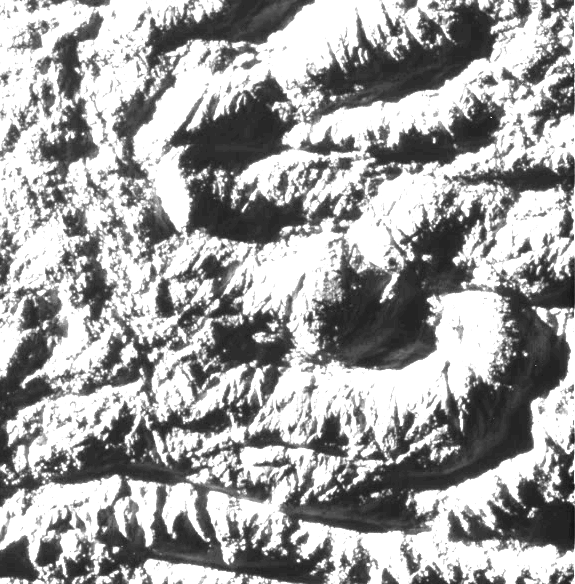
Several very interesting images of highly "wrinkled" terrain from ~20,000 km out like this one:
http://saturn.jpl.nasa.gov/multimedia/images/raw/raw-images-details.cfm?feiImageID=165849
Interestingly most/all are 2x2 binned (512x512 pixels).
Posted by: ugordan Aug 12 2008, 10:11 PM
A typical method they use for gathering color at a lower data volume cost and greater acquisition speed - one clear frame and several (usually 3) multispectral, binned frames. Problem is, this pesky line truncation can often reduce the vertical resolution by another factor of two if there's a lot of going on in the frame. There certainly is a lot going on in that frame you linked to, it caught my eye as the most interesting one so far, too. Can't wait to see that in full res.
Posted by: elakdawalla Aug 12 2008, 10:22 PM
Just for fun, trying to follow along with where these frames are. The graphics from the "looking ahead" article really help out a lot. I've downloaded each of the images from the south polar mosaic, de-interlaced them, and rotated them 180 degrees to match the orientation of the maps.
http://planetary.org/data/cassini/enceladus_080_raw.html
--Emily
Posted by: Ken90000 Aug 12 2008, 10:25 PM
Wow Emily:
That was fast.
Gret job.
Posted by: ugordan Aug 12 2008, 10:27 PM
I second that, great work, Emily. I might as well quit looking at the raws page and just wait for them to appear at your page, all nice and dandy
If I get it correctly, the highest resolution view will be somewhere in the top center portion of this footprint: http://planetary.s3.amazonaws.com/data/cassini/enceladus/raw/17495_N00118311_GRN_di_rot180.png
Posted by: Stu Aug 12 2008, 10:29 PM
Was just thinking the same thing... excellent work Emily, thanks on behalf of everyone following the adventure!
Posted by: belleraphon1 Aug 12 2008, 10:31 PM
Stu.... does my head in constantly.
My workmates appreciate my enthusiasm, but simply do not FEEL the esctasy of the moment the way I do.
Every UMSFer has this spacer consciousness.... (well, if you did not, you would not be on this forum, would ya...duh) the only thing better would be to BE THERE IN PERSON.
We woke up this morning with these vistas unseen..... and soon a page in space history will turn and we see scenes
no human ever has.
It IS amazing.
Craig
Posted by: Holder of the Two Leashes Aug 12 2008, 10:34 PM
Bloggette par Excellence!
Posted by: belleraphon1 Aug 12 2008, 10:37 PM
Emily ... you are fantastic!!! Thanks So much.
Craig
Posted by: ugordan Aug 12 2008, 10:51 PM
Using Emily's page and planned imaging footprints, here's what I get for a rough location of the highest resolution 8 m/pix image:

|
The uncertainty of my location is probably something like +/- 0.5 NAC FOV on both axes. It'll be interesting to see where the actual footprint landed given the timing sensitive skit shoot.
Posted by: vmcgregor Aug 12 2008, 11:05 PM
Update: At 23:00 UTC, in 4 minutes, we'll have some additional images manually posted to the blog at http://blogs.nasa.gov/cm/blog/cassini-aug08/
and the saturn page at saturn.jpl.nasa.gov and the CICLOPS page.
Posted by: JTN Aug 12 2008, 11:07 PM
Here they come...
http://saturn.jpl.nasa.gov/multimedia/images/image-details.cfm?imageID=3182
Wow.
Posted by: volcanopele Aug 12 2008, 11:12 PM
Close up images are now up at http://ciclops.org/view_event/88/Skeet_Shooting_Enceladus?js=1
Posted by: Stu Aug 12 2008, 11:19 PM
I'm sorry, but that's just ridiculous...
Those are absolutely STUNNING...
Any CASSINI guys reading this... you are AWESOME. Many, many congratulations on those breathtaking images. Classics within moments of them being released.
Posted by: Bjorn Jonsson Aug 12 2008, 11:22 PM
WOW!!!!!!!!!!!!!!!!!
Assuming the pointing is accurate: Big congratulations to everyone involved.
This is beautiful - the images look sharp despite the fast relative Cassini-Enceladus motion. There's even some detail visible in the shadowed areas.
Again: WOW!!!!!!!!!!!!!!
Posted by: elakdawalla Aug 12 2008, 11:23 PM
Awesome!
I just updated my page. Skeet shoot 1, 3, and 4 are interestingly chosen -- they can be mosaicked.
http://planetary.org/data/cassini/enceladus_080_raw.html
--E
Posted by: belleraphon1 Aug 12 2008, 11:25 PM
To me SKEET#7 looked at first glance as if there was some wispy plume activity, but I think it is actually just smooth icy terrain giving an illusion of plumes.
I am absolutely AGOG!!! I do not see any blurring..... incredible job.
THANKS CASSINI TEAM for getting these out to us so quickly!!!!!!!!!!!!
Posted by: ugordan Aug 12 2008, 11:28 PM
Outstanding imagery and crystal clear, no sign of motion smear! Congrats to all involved!
Here's the actual http://ciclops.org/view/5188/Enceladus_Rev_80_Flyby_Skeet_Shoot_1 context:
|
What a way to really kick off the extended mission!
Posted by: JTN Aug 12 2008, 11:29 PM
Fine texturing on inner surface of ridges (e.g., http://photojournal.jpl.nasa.gov/catalog/PIA11107) reminiscent of Europa (e.g., http://photojournal.jpl.nasa.gov/catalog/PIA00849), at least to me. Probably no big surprise.
[EDIT: Scale looks to be about the same, too.]
Thanks so much for putting these up.
Posted by: Bjorn Jonsson Aug 12 2008, 11:29 PM
After a quick look at the images the pointing seems very accurate at least for the last one - I was too excited to check for this when I first saw the images. Again, congratulations.
Posted by: mhoward Aug 12 2008, 11:33 PM
Those are absolutely insane. Never seen anything quite like it.
Posted by: elakdawalla Aug 12 2008, 11:37 PM
Mosaic of skeet shoot 3 & 4, with Cairo Sulcus across the center and an unnamed fracture in upper left corner. I couldn't make skeet shoot 1 match -- maybe the geometry shifted enough that it's not just a matter of shrinking and tiling it in?
--Emily
|
Posted by: Bjorn Jonsson Aug 12 2008, 11:39 PM
The last skeet shoot frame looks somewhat similar Europa, especially the big fracture near top. For example, take a look at this Europan fracture:
http://photojournal.jpl.nasa.gov/catalog/PIA00589
Posted by: volcanopele Aug 12 2008, 11:45 PM
I just updated my page. Skeet shoot 1, 3, and 4 are interestingly chosen -- they can be mosaicked.
shhh, don't say that!
Posted by: Stu Aug 12 2008, 11:52 PM
Good thing CASSINI didn't get any closer... remember what happened to the Millenium Falcon...
|

Posted by: ugordan Aug 12 2008, 11:56 PM
My attempt at a 1, 3, 4 quickish mosaic before calling it a day:
|
Posted by: jmknapp Aug 13 2008, 12:00 AM
Here's a comparison of predicted (NAIF data) vs. actual pointing for SS #7:
actual: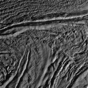
predicted: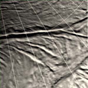
Looks shifted a bit. I used Steve Albers' map for the predicted image. It'd be really interesting if they see differences in the surface from the earlier shots.
Posted by: belleraphon1 Aug 13 2008, 12:05 AM
Yeah... especially like those cavernous structures in skeet#4.
Look very shoggoth friendly 
Spelunking anyone?
Craig
Posted by: volcanopele Aug 13 2008, 12:05 AM
You have a cleaner mind that me when I first saw that feature.
Posted by: Holder of the Two Leashes Aug 13 2008, 12:08 AM
I'm going to force myself away from the pictures long enough to add my congratulations to the Cassini team. Well done.
Posted by: Bjorn Jonsson Aug 13 2008, 12:08 AM
There might be a discrepancy between the Albers and "official" maps so this might actually be less (or if unlucky: more) shifted. I'm too lazy to check this now (I'm just enjoying the new images at the moment) but I know there was some discrepancy between the Mimas maps (I've been building a DEM of Mimas using stereo pairs so I'm rather familiar with Mimas imagery and maps).
Posted by: tedstryk Aug 13 2008, 12:10 AM
One can really make a lot out in the dark, thanks to reflected light.

|

|
Posted by: mgrodzki Aug 13 2008, 12:15 AM
so can we assume that there are particles streaming from these fractures, but they are just so fine we cannot see them? i would have expected at least a haze or something like that, no?
oh and
wow. shocking clarity.
Posted by: belleraphon1 Aug 13 2008, 12:23 AM
oh and wow. shocking clarity.
There are some hints of haze, especially in skeet#7, but cannot really tell if real or an illusion do to smooth ice/snow draping the terrain.
Craig
Posted by: belleraphon1 Aug 13 2008, 12:39 AM
Sorry for all these one liner WOWS....... but just cannot help it.
These images are so crisp we can count the feakin boulders. Let our eyes wander the shades, shadows, and snow sprinkled margins, can imagine standing frozen in awe on the lips of those groaning fractures.
Just beautiful...... what a moment.
Thanks CASSINI team.... this is Golden.
Craig
Posted by: jmknapp Aug 13 2008, 12:46 AM
Here's a crop:
the wispy stuff seems to jut into the shadow areas.
Posted by: belleraphon1 Aug 13 2008, 01:03 AM
Thanks jmknapp. Hard to really tell whats going on here.
Craig
Posted by: jmknapp Aug 13 2008, 01:08 AM
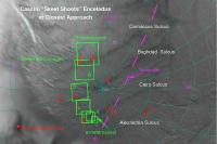
Note that SS7 is in an active vent region (the circle marked II below), between hotspots D and F:
From Anne Verbiscer's description:
Posted by: belleraphon1 Aug 13 2008, 01:19 AM
Hmmmmmmmmmmmmmm.... thanks... very interesting indeed. Cannot wait for all the science teams to integrate all their data!!!!
Craig
Posted by: mchan Aug 13 2008, 01:32 AM
Adding my congratulations to the Cassini team for this excellent work, and thanks for getting out the early looks so quickly.
Posted by: nprev Aug 13 2008, 01:33 AM
 ...that is a VERY suggestive crop, Joe; thanks! (I understate; that's an APOD submission if I ever saw one.)
Major congratulations to the Cassini team; what an achievement!!!
Posted by: mchan Aug 13 2008, 01:42 AM
Freaking house-sized boulders.
(Or, dare I say it, freaking shoggoth-sized boulders!)
Posted by: Hungry4info Aug 13 2008, 01:46 AM
I must say I'm quite amazed by these images. Are these the highest-resolution images ever taken of Enceladus? Or are the ones from 2005 a tad better?
Also, I'm sure you all know this, but the next Cassini flyby of Enceladus will happen in 57 days, and will fly by Enceladus at an altitude of 25 kilometres... half the altitude of this flyby. Does anyone know where Cassini will be near closest approach? And what is the observation agenda? If if anything like this, and I hope it is, we should get some even more awesome images of Enceladus.
If anyone with the Cassini Team goes to this forum: I personally thank you, and congratulate you for this awesome achievement here!
Posted by: belleraphon1 Aug 13 2008, 01:53 AM
I'm tellin ya..... those caverns to the right in this version of skeet#4 are perfect shoggoth holes.
http://planetary.s3.amazonaws.com/data/cassini/enceladus/raw/02621_PIA11109_rot180.png
Seriously.... just like the curly symmetry of those structures...... (apologies to our geology friends for the terminology).
Really interesting surface.
Craig
Posted by: Hungry4info Aug 13 2008, 01:58 AM
http://planetary.s3.amazonaws.com/data/cassini/enceladus/raw/02621_PIA11109_rot180.png
Must be a really small shoggoth
On a more serious note, in the bottom of that... hole... would be an amazing place to stand up and look around (with ample lighting of course).
Posted by: jsheff Aug 13 2008, 01:59 AM
My congratulations also to the Cassini team; this is as real as exploration gets!
And thanks, Emily, for helping to put it all in context!
BTW, it's striking how there are no impact craters here, at any resolution. This is a young surface, everywhere.
- John Sheff
Cambridge, MA
Posted by: mgrodzki Aug 13 2008, 02:06 AM
the wispy stuff seems to jut into the shadow areas.
that is the same area i was thinking i saw that as well its hard to say if that is some kind of streaming material or just reflected light on an icy surface. i mean we are looking at an active vent, but just cannot see the materials venting at this close a view right? suppose this is only something we can see happening back-lit from afar or perhaps if we were right on the ground looking straight at it?
Posted by: belleraphon1 Aug 13 2008, 02:08 AM
On a more serious note, in the bottom of that... hole... would be an amazing place to stand up and look around (with ample lighting of course).
Ah, my Hungry friend .. that hole is actually pretty big when you figure that the resolution here is 66 feet per PIXEL
And yes, be something indeed to stnad there and look around.
Craig
Posted by: Floyd Aug 13 2008, 02:12 AM
Thanks all on the Cassini team for obtaining and sharing these fantastic images. Also thanks for providing excellent and extensive information about this encounter this past week.
-Floyd
Posted by: mchan Aug 13 2008, 02:18 AM
It's been pointed out here that imaging would be smeared by the flyby speed if done at closest approach . The highest resolution image this time around was from 1300 Km range.
As I recall, the XM Enceladus encounters for this year all have relatively high flyby speeds. The encounters in 2009 and 2010 have less than half the 2008 flyby speeds and may offer more opportunities for higher resolution images.
It would be awesome if a slow flyby like that of Iapetus could be done for a very close approach of Enceladus, but that is not in the cards at this time.
Posted by: elakdawalla Aug 13 2008, 02:24 AM
Although the next flyby will have similar geometry, I'm told that the closest approach will be given over to the in situ instruments -- CDA, INMS, CAPS, etc. Actually, it's great there's two flybys right over the south pole with similar geometry so that optical remote sensing can control one and fields'n'particles can control the other. ORS got first dibs. So we're not going to get anything like this next time.
A little bird told me that most of the images are down -- and was surprised they haven't shown up on the raws page yet. F5, F5, F5, F5, F5, F5, F5, F5........I'm going to singlehandedly break the Cassini website
There's really not any possibility of a slow flyby past Enceladus because of the orbital geometry. Enceladus is pretty close to Saturn, so Cassini always flies past it at periapsis, when it's traveling quite fast. The Iapetus flyby happened at apoapsis on a really big orbit, so it was quite slow. Only way to do a slow flyby past Enceladus is if Cassini changes its orbit to be really really small, with apoapsis nearer to Enceladus.
--Emily
Posted by: elakdawalla Aug 13 2008, 02:27 AM
Whoah -- F5 worked -- new stuff! Inbound stuff, lots of it. Can the rest of the Skeet Shoot be far behind?
--Emily
Posted by: elakdawalla Aug 13 2008, 02:33 AM
Here's the WAC that started off the Skeet Shoot
http://saturn.jpl.nasa.gov/multimedia/images/raw/raw-images-details.cfm?feiImageID=165976
Oh my -- it's all there. Got to go bathe the baby and put her to bed and then it's playtime for Mommy!
Posted by: Juramike Aug 13 2008, 02:41 AM
http://saturn.jpl.nasa.gov/multimedia/images/raw/raw-images-details.cfm?feiImageID=165976
At 545 km!!
Ha! Looking at those sharp fractures, faults and cracks, it seems that the Cassini platform is more stable than the surface is!
Beautiful job!
-Mike
Posted by: nprev Aug 13 2008, 03:03 AM
..Don't know how you do it all, ma'am, but thanks so much for doing it!My idea of multitasking is to open a beer while simultaneously surfing UMSF...
Posted by: belleraphon1 Aug 13 2008, 03:22 AM
..Don't know how you do it all, ma'am, but thanks so much for doing it!My idea of multitasking is to open a beer while simultaneously surfing UMSF...
Yes, Emily, we all truly appreciate what you do. My office mates (both female) tell me that men can't multi-task.
UH.... what was I gonna do next ???? Darn. Had it a minute ago....
Craig
Posted by: elakdawalla Aug 13 2008, 03:25 AM
Just for fun, here's the WAC "shot in the dark." I don't think there's anything to be seen -- except for the coolness of the caption, "The camera was pointing toward ENCELADUS at approximately 202 kilometers away..."
http://saturn.jpl.nasa.gov/multimedia/images/raw/raw-images-details.cfm?feiImageID=165974
--Emily
Posted by: mchan Aug 13 2008, 03:40 AM
The speeds are high because the eccentricity of Cassini's orbit is so high right now. Drop the eccentricity while maintaining the encounter with Enceladus near periapsis, and the flyby speed would also drop. E.g., there are some distant encounters of Pandora and friends in 2010 near periapsis that have slower flyby speeds than Iapetus in 2007. However, I am guessing here that to do something similar for Enceladus using Titan flybys would require a long time (years?) and a lot of delta-V to setup due to phasing. E.g., imagine a Hohlmann with periapsis at Enceladus orbit and apoapsis just beyond Titan orbit.
Posted by: belleraphon1 Aug 13 2008, 03:46 AM
Hm...
Just a general impression looking at all the skeet shot images.....but I get the feeling that the active vent regions may
be adjacent to the lighter toned and more muted fracture zones. Lighter tones might be due to snow emplacement as plumes blow off their material.
Really looking forward to what the other instruments saw and also the refined targeting analysis as to which areas along the tiger stripes really got imaged....
And I remembered what I was going to do next..... get to bed given I have to get up for work in four hours.
Amazing night friends.....
Craig
Posted by: CosmicRocker Aug 13 2008, 04:07 AM
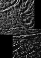
I managed to stitch 1-2-3-4. I can't get 5 to match. I'm not sure, but there seems to be very little, if any, overlap between 4 and 5. I had to reduce the size to 75% and convert the png to jpg to get it to an acceptable size to upload here.

|
Posted by: CosmicRocker Aug 13 2008, 04:17 AM
Here is the 6-7 stitch. This is at full size, but jpeg compressed.
BTW, both of my mosaics have been rotated 180 degrees to match the skeetshoot closest aproach map on http://planetary.org/data/cassini/enceladus_080_raw.html.

|
Posted by: dvandorn Aug 13 2008, 04:37 AM
I played a little with brightness and contrast on what I think is Skeet Shoot 1 (at least it's the first one to be posted in the thread), and I'd like y'all to take a look at this and tell me if you see what I see:

|
It looks to me like there is a braided channel in the bottom of this big crack. The lighter-toned material appears to flow around darker material, and the whole thing bears a remarkable resemblance to braided river beds on Earth.
I'm having a hard time imagining the kind of processes that might account for this kind of thing in Enceladan conditions. Any thoughts?
-the other Doug
Posted by: mgrodzki Aug 13 2008, 04:40 AM

i know we were looking at a similar area previously for venting
but i think this area is really more interesting. does anyone else think that the wispy/wavy lines on the upper edge of the fracture is plume venting?
Posted by: dvandorn Aug 13 2008, 04:46 AM
Yes.
-the other Doug
Posted by: mgrodzki Aug 13 2008, 04:55 AM
-the other Doug
word.
Posted by: mchan Aug 13 2008, 05:02 AM
Elaborate?
The discussion prior to the flyby made the points that venting is extremely low density and essentially invisible with the phase angles in these images. If the image here is showing some kind of flow, it appears to be of slow velocity like fog drifting over and down on incline, not the escape velocity gas that erupts and goes into the E-ring. You'd have to postulate a new mechanism to explain what this might be.
Posted by: MizarKey Aug 13 2008, 05:06 AM
http://saturn.jpl.nasa.gov/multimedia/images/raw/raw-images-details.cfm?feiImageID=165976
Oh my -- it's all there. Got to go bathe the baby and put her to bed and then it's playtime for Mommy!
I've blown W00048467 up 4x, lightened it and cropped the area of interest. The three areas I've pointed to seem to remain bright past the edge of the crevasse.

|
Posted by: Shaka Aug 13 2008, 05:20 AM
What about all that similar stuff right below the word "outgassing"?
Posted by: Exploitcorporations Aug 13 2008, 05:26 AM
Effin' aststonishing ...congratulations and thanks to the ISS team.
Here's a stitch of the 8-frame south polar mosaic at reduced scale.

|
Posted by: mchan Aug 13 2008, 05:28 AM
Wowza! Beautiful work.
Posted by: CosmicRocker Aug 13 2008, 05:32 AM
O'Doug: I think that is closest-approach image #4. I have been playing with contrast stretching the darkest regions in these images, and I've seen the kinds of patterns you are describing.
While they do bear some resemblance to braided channels, I think they could very well be the same kinds of faults and fractures apparent in the more brightly illuminated areas. The contrast in these deep, dark cracks is pretty low, and fine detail is lacking.
Posted by: Stu Aug 13 2008, 06:03 AM
Was hoping you'd join the imaging party for this one! That is gorgeous, thanks! I could - and will - scroll and pan around that image for ages...
Posted by: dvandorn Aug 13 2008, 06:16 AM
While they do bear some resemblance to braided channels, I think they could very well be the same kinds of faults and fractures apparent in the more brightly illuminated areas. The contrast in these deep, dark cracks is pretty low, and fine detail is lacking.
Yeah -- in fact, in the 6-7 mosaic a similar crack has a slightly more well-illuminated floor, and the dark "islands" appear to resolve into cracks within the lighter-toned material. I'm beginning to lean towards the concept that the dark cracks are vents, and the lighter-toned materials are mass buildup as some of the escaping water vapor condenses out into ice along the sides of the vents.
That feeling is reinforced by a couple of details from the 6-7 mosaic, where what appear to be vapor effects swirl off the top of small deposits of the light-toned material. I think it actually shows vapor coming out of the vent, with part of the plume spraying off of the slowly building ice construct.
It remains, though, that the light-toned materials and the dark areas that *may* be vents do meander. I see no indication of dendritic branching, so there is no surface drainage involved, but the dark streaks and the light materials meander within the confines of the floors of the large V-shaped valleys. Could we possibly be seeing the surface expression of underground flows of hot ice, or even liquid water? That might explain the meandering quality of these units.
-the other Doug
Posted by: centsworth_II Aug 13 2008, 06:29 AM
There is a definite softening of the terrain in some areas in contrast to the relative sharpness in others. Could this be from deposition of "snow" or "sleet"?
Posted by: Gladstoner Aug 13 2008, 06:33 AM
.
Posted by: Exploitcorporations Aug 13 2008, 07:17 AM
Here's the Skeet-Shoot mosaic in context.

|
Posted by: djellison Aug 13 2008, 07:40 AM
I don't think that's outgassing - I think it's simply snowy deposits from where the outgassing is happening. As people have said time and again, the outgassing is so optically thin, you're never going to see it in anything other than very extreme lighting conditions.
Posted by: Astro0 Aug 13 2008, 08:00 AM
Just taking a bunch of the released images and placing them together to provide context for the Skeet Shoot shots.

|
A breathtaking place!
Astro0
Posted by: Tman Aug 13 2008, 08:05 AM
Don't think too. In vacuum, without any other medium to react, the gas have to be even denser to cause smearing in photos.
Speaking of multitasking I just have breakfast and watching the time trial at the Chinese wall while enjoying additionally all these outstanding pictures, mmmmh!
Posted by: ugordan Aug 13 2008, 08:27 AM
I'd like to join Doug in once again emphasizing just how faint these plumes really are. People, they are exceedingly faint. Seeing outgassing in this imagery is an exercise in human eye seeing what it wants to see rather than what is really there. They simply cannot be seen under any but very high phase angles and even then you have to cut down on other sources of light in the scene. The viewing geometry in these shots is nowhere near favorable for seeing the plumes against darkness of space let alone against sunlit terrain.
Posted by: Exploitcorporations Aug 13 2008, 08:28 AM
For better visibility of the smaller footprints, here's a blowed-up section of the mosaic.

|
Posted by: jmknapp Aug 13 2008, 10:43 AM
Wow, amazing collection of images and mosaics to wake up to!
On interpreting shadows, etc., in SS7, it's important to know the direction of the fairly low sun: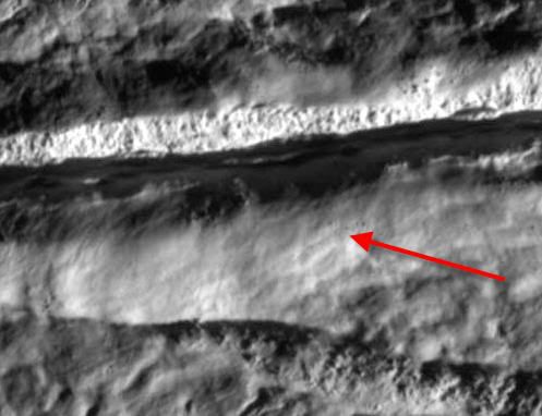
So the shadow behind the main ridge is actually quite long, just at an oblique angle. For example, one can see the shadow of the jagged bit of ridgeline above the arrow cast quite a bit off to the left at the bottom of the crevasse.
Posted by: jmknapp Aug 13 2008, 11:47 AM
On the other hand, saying categorically that the geysers are thus-and-so based on information to date could come under the blind men and the elephant problem. The jets imaged so far are those with very small particles (even gas) that have reached escape velocity and can be imaged far out into space, but other things could be going on near the surface, even chunks of ice being thrown a short distance.
Posted by: Juramike Aug 13 2008, 11:59 AM
I'm having a hard time imagining the kind of processes that might account for this kind of thing in Enceladan conditions. Any thoughts?
Tidally driven cycloid cracks?
(It has been proposed for the Tiger Stripes of Enceladus) Maybe this is some type of sub-harmonic???
-Mike
Posted by: belleraphon1 Aug 13 2008, 12:12 PM
Good Morning All (at least it is morning (08:00am) in NE Ohio, USA, Earth).
Logging in from work for just a moment.... had to say a big thanks to all you image mages for the mosaics you've done ..
Exploitcorporations... welcome back online and your stuff always blows me away... incredible.
Fascinating to compare the Enceladean south polar terrain to what we see at Europa. Commonalities in the geophysics
of ice bodies are showing through....
As for that haze some of us think we are are seeing... probably take some anaysis to confirm of not... and I agree with jmknapp that we could be seeing other processes on the surface.
Ain't it great we have the data to even ask the questions (right or wrong).
Craig
Posted by: belleraphon1 Aug 13 2008, 12:33 PM
All..
look inside the fracture in
http://planetary.s3.amazonaws.com/data/cassini/enceladus/raw/02628_N00118365_rot180.png
Is that shadow or is there a "seam" of darker material running along the inside?
Craig
Posted by: bobw Aug 13 2008, 12:42 PM
I have been looking forward to searching for hot spots in Damascus Sulcus since that picture was supposed to be the best one to see the bottom of the fracture. The captions for the "Skeet Shoot" images says they are upside-down from the track preview images so I rotated http://ciclops.org/view/5190/Enceladus_Rev_80_Flyby_Skeet_Shoot_7?js=1 , brightened it up and had a look.
It looks like the frozen waterfalls from my ice climbing days overlaying the bottom edge of the rift. I think this spot is in about the same place as the one with the yellow circle.
Does that stuff look like 3 km icicles to anybody else?

|
P.S. Great coverage of this topic here. Thanks for the big mosaics.
Posted by: ilbasso Aug 13 2008, 12:54 PM
My first visual impression of some of the closeups is "elephant skin."
And our rushing to interpret reminds me of the tale of the blind men and the elephant, who each felt only a piece of the elephant and declared it to be something completely different.
Posted by: ugordan Aug 13 2008, 01:06 PM
My guess is it's a shadow with the higher parts of the shadowed ridge cliff illuminated by sunlight off the other side, making them look brighter. If only there was time to see this area in IR3 vs shorter wavelength filters during the closest imaging phase...
I'd expect the whole sulci and immediate surrounding to be "bluish" crystalline ice, but it would be interesting if any significant small scale variations would be seen. Overall, the crystalline ice is less reflective in the long infrared (hence the blue-green color in false color shots) so it would appear slightly darker than pure, amorphous ice would through the clear filter. I *think*.
Posted by: pioneer Aug 13 2008, 01:43 PM
Does this surface remind anyone of Europa? It sure does for me.
Posted by: djellison Aug 13 2008, 02:01 PM
It reminds of the love-child of our moon and Europa. Cracked...but smooth in places.
Posted by: bobw Aug 13 2008, 02:06 PM
It doesn't look to me like the surface of Enceladus has broken up as much as Europa. I haven't noticed anyplace that looks like a rotated ice floe but have seen places that look like they have slipped along a fault and places that look like they have been flooded.
Posted by: Ames Aug 13 2008, 02:21 PM
What I find interesting is that the high ridges either side of the "scratches" seem to be much smoother than the surrounding plains (if you can call them plains!).
I would have thought that the ridges, having been thrust up, would have been much more highly textured.
Could deposition of say, "snow" or dust be burying the finer scale geology locally to the vents.
Ok we can't directly see the vents or what is vented, but we can see the fallback.
Nick
Posted by: volcanopele Aug 13 2008, 02:25 PM
Brain-dead after working on Enceladus images since a little after noon yesterday....
Posted by: nasaman58 Aug 13 2008, 02:39 PM
After the flyby, I stretched the first photo--taken with the most extreme sun angle--to see detail in the shadows. Think that's reflected light? Here's a link to the original from Emily's blog ( http://planetary.org/image/01288_PIA11105_rot180.png ). In my stretched, note the craters in the bottom left shadow. Maybe this part is tad older.

|
Posted by: ElkGroveDan Aug 13 2008, 02:56 PM
All that faulting makes me think "tectonic." I can imagine standing on that surface and feeling a steady rumble with frequent severe shaking. My gut feeling is that this surface is very, very active on time scales we are accustomed to. I can't wait to see comparison photos between the same locations several months apart - assuming such images are planned down the road.
Posted by: Hungry4info Aug 13 2008, 02:59 PM
A little bit brighter than the E-ring, right?
And the E-ring is completely invisible to the naked eye.
Posted by: jmknapp Aug 13 2008, 03:26 PM
Anyone else finding the CICLOPS Skeet Shoot web page very slow this morning? Looks like the images are a smash hit.
Posted by: Stu Aug 13 2008, 03:31 PM
Not sure why, but my eyes keep wandering back to this big boulder and its loooong shadow, seen on Skeet Shoot #3...

|
Posted by: tedstryk Aug 13 2008, 04:56 PM
I can't wait for the pds release of the shot in the dark from 202 km. I don't think it shows anything, but there are some tantalizing features that might, just might, actually be something, but I can't tell with the jpeg artifacts.

|
Posted by: scalbers Aug 13 2008, 06:49 PM
I'm still catching up with all the amazing images and posts. I have found that my Enceladus map is off by about 1-2 degrees near the south pole, mostly along the direction of the largest tiger stripes. This encounter in conjunction with the recently updated official map (together with info on Emily's Enceladus page) should help me quite a lot in filling in the gaps and assessing the correct geometry. Now all I need is a generous supply of time for the purpose of updating the map.
Steve
Posted by: Philotas Aug 13 2008, 08:39 PM
Note the ridges inside the sulci; like in http://www.nasa.gov/mission_pages/cassini/multimedia/pia11107.html of Damascus Sulci:
(click on the image for full resolution)
http://img55.imageshack.us/img55/1809/5190116611kopifd1.jpg
Posted by: David Aug 13 2008, 08:40 PM
The technical term for a tall, upright stone (or other block) standing widely separated from other upright objects is:
monolith.
Posted by: David Aug 13 2008, 08:42 PM
One is a sulcus, that is, "a furrow" in Latin; two or more are sulci.
Posted by: Philotas Aug 13 2008, 08:48 PM
Noted.
Posted by: tty Aug 13 2008, 09:39 PM
In Skeet #5 it is interesting to compare the two faults in the lower part of the image. The upper fault apparently has moved very little since features match across the fault with very little offset. The lower fault on the other hand has moved quite a bit - features don't match at all across it.
Posted by: Astro0 Aug 14 2008, 01:05 AM
A poster to celebrate this encounter...Enjoy

|
Astro0
PS: I'll post a link to higher res version on this thread later today.
Posted by: nprev Aug 14 2008, 01:22 AM
Oh, man...now I have to find a color plotter somewhere at work, 'cause I want this for my office! Beautiful work, Astro0, thank you!!!
Posted by: Juramike Aug 14 2008, 01:57 AM
Beautiful work, Astro0!!
(And super-fast, too! Didn't those images just come down, like, yesterday?)
Posted by: elakdawalla Aug 14 2008, 02:25 AM
I finally got a chance to finish laying out the raw images page for the Skeet Shoot and south pole mosaic. All images are de-interlaced and rotated 180 to match the orientation of the maps. One set of images from that south pole mosaic seems to be missing -- I think -- someone please point me to the images if I'm wrong!
http://planetary.org/data/cassini/enceladus_080_raw.html
--Emily
Posted by: ElkGroveDan Aug 14 2008, 02:37 AM
Great work - really user-friendly. Thank you for taking the time to create that page.
Posted by: JTN Aug 14 2008, 02:50 AM
A couple of random thoughts on looking through the rest of the raws:
In the outbound full-disc views, it's striking me how dark the whole south polar region looks to me (subjectively, at least). The "tiger stripes" are particularly dark in IR, of course (http://saturn.jpl.nasa.gov/multimedia/images/raw/raw-images-details.cfm?feiImageID=165997, http://saturn.jpl.nasa.gov/multimedia/images/raw/raw-images-details.cfm?feiImageID=165992) -- the "blueness" http://photojournal.jpl.nasa.gov/catalog/PIA06249 -- but even through some of the other filters (http://saturn.jpl.nasa.gov/multimedia/images/raw/raw-images-details.cfm?feiImageID=165999) the south pole looks darker than other parts that close to the terminator -- kind of a dark smudge. Does dark=smooth here?
(Apropos of nothing in particular, I just rediscovered http://photojournal.jpl.nasa.gov/catalog/PIA03551 of the south polar region.)
http://saturn.jpl.nasa.gov/multimedia/images/raw/raw-images-details.cfm?feiImageID=165973 and nearby images look like a stellar occultation while Enceladus was in eclipse (I assume it's not a moon as we're staring at the south pole). Were other any instruments observing this? Would we be looking "down the plume" to any meaningful extent at this point?
Posted by: jasedm Aug 14 2008, 09:24 AM
Well, I can only echo the sentiments of others here - fantastic images, magnificent flyby!
I'd never heard of Paul Helfenstein prior to the flyby (he apparently designed the 'skeet-shoot' images), but if he's ever down my way, there's a beer or two waiting for him.
Can't wait to see the CIRS results overlaid on the imaging data - did they properly nail those vents?
Wonderful.
Posted by: jmknapp Aug 14 2008, 11:16 AM
http://planetary.org/data/cassini/enceladus_080_raw.html
Great reference--bookmarked!
Also, excellent real-time image processing on the http://www.ustream.tv/recorded/631822 ustream webcast yesterday.
Posted by: vexgizmo Aug 14 2008, 11:49 AM
Me too...
Posted by: Astro0 Aug 14 2008, 12:00 PM
As http://www.unmannedspaceflight.com/index.php?showtopic=5371&view=findpost&p=123626 above, I have linked the higher res version of the 'Skeet Shoot' poster http://www.speedyshare.com/377667638.html.
Enjoy
Astro0
Posted by: john_s Aug 14 2008, 01:56 PM
Yup, we nailed the vents- see my http://blogs.nasa.gov/cm/blog/cassini-aug08 on the Cassini blog.
Paul Helfenstein, at Cornell, has designed most of the Enceladus image sequences throughout the Cassini tour. This one was by far the most difficult so far, though, because Enceladus was moving so fast across the sky during the "skeet shoot" phase, and the spacecraft had very limited ability to keep up with it. Paul's achievement was to get the cameras to point where we wanted them to in a situation where our pointing ability was extremely compromised.
Posted by: nprev Aug 14 2008, 02:15 PM
Thanks for the insight, John, and congratulations to you all again...'magnificent' is probably the best adjective I can summon, and it don't seem like enough!
What kind of spatial resolution are you expecting from the CIRS data? Presumably, it's of great interest to see how the local heating is distributed across the neighboring crust in addition to pinning down the actual hot spot sources themselves.
Posted by: ugordan Aug 14 2008, 02:17 PM
And to add to that question, when can we expect some numbers? Preferably in Kelvins or Celsius, not Fahrenheits.
Posted by: jmknapp Aug 14 2008, 02:36 PM
From the http://blogs.nasa.gov/cm/blog/cassini-aug08.blog/posts/post_1218645638510.html (Bonnie Buratti):
Somewhere, something incredible is waiting to be known. --Carl Sagan
Posted by: ugordan Aug 14 2008, 05:49 PM
A bit of IR3/GRN/UV3 color while we wait for official products. From the eight-tile mosaic, only frames 1 and 2 mosaicked here.

|
Posted by: nprev Aug 14 2008, 05:54 PM
Egad, Gordan!!! Absolutely striking!
I take it that the blue-green color is not natural?
Posted by: ugordan Aug 14 2008, 05:57 PM
No, it's not natural:
Posted by: volcanopele Aug 14 2008, 06:06 PM
Well, it is natural, you just wouldn't see it with the naked eye. Okay, maybe a little, but it wouldn't be that obvious.
Posted by: nprev Aug 14 2008, 06:12 PM
Thanks, Gordan; missed that. Also thanks VP.
Um...interesting. Very.
Posted by: JRehling Aug 14 2008, 07:30 PM
It seems like some basic math should set some parameters on this. If the outgassing were so intense as to be visible, the accumulation of deposits over geological time would have to be incredible. The whole area should be absolutely flat if that were the case. Basically, it seems like comparing the texture of the deposit area and the texture of the adjacent areas without the deposits should give a rough measure of its depth, and from that we could start to talk about the age of the surface and the rate of the deposition (that's two degrees of freedom, and we only have one firm measure, but the relationship between the two should be derivable).
Of course, in a sense, we *are* seeing the outgassing. We just seeing it where it fell down and went to sleep for the last 100 million years or so.
Posted by: DDAVIS Aug 14 2008, 09:23 PM
Yup, we nailed the vents-
Would anyone care to mark where they think the active vents are in the actual images?
Don
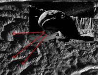
Posted by: bobw Aug 14 2008, 10:16 PM
Don
I think I found where one is, post 195 has a picture, link below. I'm not a scientist so I could be wrong
http://www.unmannedspaceflight.com/index.php?showtopic=5371&view=findpost&p=123564
Posted by: peter59 Aug 14 2008, 10:31 PM
I suspect this region. Bright spots on the bottom, dark deposits on the slope. It looks promising.

|
It's speculation only. Very credible, but it's speculation.
Posted by: scalbers Aug 14 2008, 11:34 PM
Perhaps this has already been done - as it might be interesting to compare one of these images prepared with a natural color balance (having possibly the subtle coloration) with some Earth glacier analogs of similar resolution. I do believe a blue color can be visible in earthly ice, so I wonder if this is analogous to Enceladus in any way?
Posted by: jmknapp Aug 14 2008, 11:57 PM
It's true that very blue ice is all over the Arctic/Antarctic nature shows these days. It's like with HD the secret can finally be told.
Posted by: volcanopele Aug 15 2008, 12:31 AM
Press Release: Cassini Pinpoints Jets on Saturn's Moon Enceladus
http://ciclops.org/view.php?id=5207
Mosaic: Great Southern Land
http://ciclops.org/view/5206/Great_Southern_Land
Mosaic: Damascus Sulcus on Enceladus
http://ciclops.org/view/5205/Damascus_Sulcus_on_Enceladus
Mosaic: Baghdad and Cairo Sulci on Enceladus
http://ciclops.org/view/5204/Baghdad_and_Cairo_Sulci_on_Enceladus
Enjoy!
Posted by: jmknapp Aug 15 2008, 12:58 AM
Love the Great Southern Land.
Also this quote:
Imaging scientists suggest that once warm vapor rises from underground to the cold surface through narrow channels, the icy particles may condense and seal off an active vent. New jets may then appear elsewhere along the same fracture.
Posted by: elakdawalla Aug 15 2008, 02:49 AM
Really awesome work, Jason, to get that 8 frame mosaic done so quickly, and in color to boot. You deserve a cookie.
Anne Verbiscer cleared up some confusion about that mosaic for me. I couldn't find one set of images from the mosaic -- turns out the diagram originally posted on the looking ahead article had an error, with a nonexistent "frame 3". There's now a new version of the diagram, with that spurious frame gone and with the final frame in the mosaic correctly placed. I've posted the new diagram and fixed my page at http://planetary.org/data/cassini/enceladus_080_raw.html but I still need to process and upload those last five frames. Of course...why do it now that Jason has done all the work? (I'll still do it, as that page is still valuable until the PDS release happens.)
--Emily
Posted by: claurel Aug 15 2008, 05:40 PM
Indeed--it can look almost jewel-like. Unretouched photo of some glacial ice chunks I saw in Chilean Patagonia:

|
My understanding is that the blue color is the natural color of the ice. It's only the presence of air bubbles that make it whitish, and these tend to get squeezed out when the ice is compressed at the bottom of a glacier. No idea if this is what accounts for the bluish tint on the surface of Enceladus.
--Chris
Posted by: ugordan Aug 15 2008, 06:24 PM
Whoa! That is blue!
As far as tiger stripes go, they do have a subtle blue tint to them in natural color, but it would probably be pretty hard to notice unless you looked carefully.
Here's the only good RGB shot of the stripes I could dig up from the PDS, it's a wide angle magnified 2x:

|
If this were gamma corrected, the blue color would be even less conspicuous.
Posted by: elakdawalla Aug 15 2008, 06:31 PM
Thank you, Gordan, that's a helpful image to have in the library!
Emily
Posted by: scalbers Aug 15 2008, 11:54 PM
Interesting image Gordan. In spite of the gamma correction aspect it seems to me to be a rather visible blue coloration given the fairly low resolution. I can see this easily (by comparison) if I turn off the color in the image. One could surmise the blue might look fairly impressive at high resolution in RGB.
Nice image as well Chris. I have some slides somewhere I took inside a glacier (that was tunneled out) in Switzerland and it looks like a similar deep blue.
Posted by: vexgizmo Aug 16 2008, 12:47 AM
The bluish color is generally associated with large ice grain sizes in clean ice. Ice preferentially absorbs the red light. The "bluish" false-color of Galileo Europa images is attributed to this effect, i.e. absorption of near-IR light.
In the recent press release associated with the regional-scale Enceladus false-color image ("Great Southern Land")
http://saturn.jpl.nasa.gov/multimedia/images/image-details.cfm?imageID=3188
the Cassini Imaging Team reports the following:
"Areas that are greenish in appearance are believed to represent deposits of coarser grained ice and solid boulders that are too small to be seen at this scale, but which are visible in the higher resolution views, while whitish deposits represent finer grained ice. The mosaic shows that coarse-grained and solid ice are concentrated along valley floors and walls, as well as along the upraised flanks of the "tiger stripe" fractures, which may be covered with plume fallout that landed not far from the sources. Elsewhere on Enceladus, this coarse water ice is concentrated within outcrops along cliff faces and at the top of ridges."
Posted by: scalbers Aug 16 2008, 03:01 PM
Vexgizmo and all,
Is the white color on Enceladus then due to scattering by boundaries between one crystal and another, or between a crystal and empty space? Even though we wouldn't have air bubbles on Enceladus as on Earth I wonder if there are yet some analogous situations between colorations on these two worlds? In each case I would guess a similar path length of light in clean ice (or in a large crystal) is needed to color the ice significantly.
It seems to me that on Earth one can also get blue ice in cliff faces on glaciers so that may represent a similarity. Here one may be looking at a surface of shear ice that is clean, rather than a fluffy deposit of smaller grained snow that one would see laying on the surface.
Is plume fallout then producing a clean type of ice instead of a fine grained snowy texture?
Steve
Posted by: CAP-Team Aug 16 2008, 03:23 PM
Steve, are you working on a colorized version of your Enceladus map?
Posted by: scalbers Aug 16 2008, 03:57 PM
Cap-Team - at the moment I'm endeavoring to rework the map with an emphasis on refining the navigation of the images. As an example this will help in reducing some apparent positioning errors in places such as the south pole, and some nearby mismatches between adjacent images. The mismatch that I'm most interested in correcting is near Mosul Sulci. This is appropriate in light of the new imagery having good coverage in this area. Emily's TPS page on Enceladus imagery is very helpful in getting at the spacecraft sub-points to help with the renavigation.
This discussion about blue ice does lend itself to thinking about color mapping possibilities To do this one would have to decide whether to try this in RGB natural color or in the false UV-G-IR color. If I wanted to do this in natural color, the RGB imagery may only be available in some locations. Perhaps natural color can be synthesized from the UV-G-IR filters in other locations? At any rate, making color imagery isn't really my forte so I might be able to benefit from some collaboration in producing the individual color images (if available for the B&W ones I used) for placement in the map. It may also be possible to blend low-res color information from additional images into the existing high-resolution B&W map (if they can be registered well enough). I have done this with other satellites such as Tethys and Rhea.
Steve
Posted by: scalbers Aug 16 2008, 04:42 PM
In the outbound full-disc views, it's striking me how dark the whole south polar region looks to me (subjectively, at least). The "tiger stripes" are particularly dark in IR, of course (http://saturn.jpl.nasa.gov/multimedia/images/raw/raw-images-details.cfm?feiImageID=165997, http://saturn.jpl.nasa.gov/multimedia/images/raw/raw-images-details.cfm?feiImageID=165992) -- the "blueness" http://photojournal.jpl.nasa.gov/catalog/PIA06249 -- but even through some of the other filters (http://saturn.jpl.nasa.gov/multimedia/images/raw/raw-images-details.cfm?feiImageID=165999) the south pole looks darker than other parts that close to the terminator -- kind of a dark smudge. Does dark=smooth here?
Yes, even years ago one could notice the darker character near the south pole in low-res images that helped set the stage for the unfolding mysteries. In some cases it seems to me to be due to rougher more chaotic terrain having more shadows (particularly with low sun angles). I suppose the albedo of the surface might differ a bit as well, either due to the bluish ice regions or possibly other coloring agents? Along Mosul Sulci there is a dark strip in B&W imagery that shows up as bluish in the "Great Southern Land" released mosaic.
Posted by: Juramike Aug 16 2008, 08:39 PM
The Frothy Faithful (and Frigid Faithful model too, I think) both explain a deposition of crystalline ice near the vents.
Check out:
Fortes Icarus 191 (2007) 743-748. Metasomatic clathrate xenoliths as a possible source for the south polar plumes of Enceladus. doi: 10.1016/j.icarus.2007.06.013 (Pay-for article, abstract available http://www.sciencedirect.com/science?_ob=ArticleURL&_udi=B6WGF-4P96253-2&_user=10&_rdoc=1&_fmt=&_orig=search&_sort=d&view=c&_version=1&_urlVersion=0&_userid=10&md5=52fea436c3c4b11772bd6c90ea08db78).
If I understood the model correctly, heres how the Frothy Faithful model works:
1) Volatiles produced by hydrothermal activity at rock-ice interface.
2) Volatile gases move around in solution by circulating hot magmatic fluids (hot water).
3) Gassy fluids contact ice, clathrates formed and emplaced.
4) Melts move the clathrate chunks to higher levels in the crust.
5) Above a certain point, clathrates no longer stable, they break down and release gases. (Crustal depths of 20 km or so.)
6) Gas pressure drives water magma and chunks upward.
7) Clathrate breakdown cools water magma gently and produces crystalline ice at depth.
8) Spray of gasses and ice crystals shoots out in a narrow jet (like out the barrel of a rifle), not in an umbrella-like plume.
9) Crystalline ice snows around the the vents
(I think the Frigid Faithful model might also allow slow crystallization of water at depth.)
So the pretty blue ice is consistent with both the Frigid Faithful and Frothy Faithful
Also according to the article, the Frothy Faithful model predicts "vigorous 'plucking' of the conduit walls" to rip up and throw the blocky debris found near the vents. The coarsest stuff (cryoclastic materials) will be closest to the vent/fractures. That could also make the stripes appear bluish, as the CICLOPS caption mentions.
-Mike
Posted by: scalbers Aug 16 2008, 11:01 PM
Interesting Mike, maybe worth stopping by the library. And here's another related abstract/paper:
http://www.sciencedirect.com/science?_ob=ArticleURL&_udi=B6WGF-4NMSRY0-6&_user=10&_origUdi=B6WGF-4P96253-2&_fmt=high&_coverDate=02%2F29%2F2008&_rdoc=1&_orig=article&_version=1&_urlVersion=0&_userid=10&md5=039a90197eca0fdfb482747265f6c06a
"These results suggest recent geological activity at the “tiger stripe” cracks and an intriguing atmospheric environment over the south pole where amorphous ice is produced either through intense radiative bombardment, flash-freezing of cryovolcanic liquid, or rapid condensation of water vapor particles on icy microspherules or on the surface of Enceladus."
Posted by: ugordan Aug 16 2008, 11:30 PM
To do this one would have to decide whether to try this in RGB natural color or in the false UV-G-IR color. If I wanted to do this in natural color, the RGB imagery may only be available in some locations. Perhaps natural color can be synthesized from the UV-G-IR filters in other locations?Creating natural-color looking imagery from IR/G/UV should be fairly straightforward, the moon is not a very colorful place and it would basically boil down to finding the right channel mix and saturation level to match the tiger stripe colors. The slight problem is we don't have a good high resolution shot of the stripes taken in RGB color for reference. We're stuck with distant imagery that doesn't resolve the sulci very well.
For a first iteration it would suffice to take IR3(or better IR1)/GRN/UV3 images and just desaturate them in Photoshop by say 50 units. That would leave them at roughly the "natural" amount of saturation, only the blue hue would possibly be slightly off in realistic color. Then again, blue is blue is blue - it's all subjective anyway...
Posted by: Juramike Aug 17 2008, 12:40 AM
http://www.sciencedirect.com/science?_ob=ArticleURL&_udi=B6WGF-4NMSRY0-6&_user=10&_origUdi=B6WGF-4P96253-2&_fmt=high&_coverDate=02%2F29%2F2008&_rdoc=1&_orig=article&_version=1&_urlVersion=0&_userid=10&md5=039a90197eca0fdfb482747265f6c06a
Thanks for that link!
The companion paper behind it is also very interesting:
http://www.sciencedirect.com/science?_ob=ArticleURL&_udi=B6WGF-4PVPVV3-1&_user=10&_coverDate=02%2F29%2F2008&_alid=778521992&_rdoc=11&_fmt=high&_orig=search&_cdi=6821&_sort=d&_docanchor=&view=c&_ct=40&_acct=C000050221&_version=1&_urlVersion=0&_userid=10&md5=d50ff71782f43e7523d30810dc34335f
"Our measurements show that the particle diameter of water ice increases toward younger tectonically altered surface units with the largest particles exposed in relatively fresh surface material. The smallest particles were generally found in old densely cratered terrains. The largest particles ([ca.] 0.2 mm) are concentrated in the so called tiger stripes at the south pole. In general, the particle diameters are strongly correlated with geologic features and surface ages, indicating a stratigraphic evolution of the surface that is caused by cryovolcanic resurfacing and impact gardening."
Ice chunks coughing out of the vents, snow everywhere else...
-Mike
Posted by: JRehling Aug 17 2008, 03:48 AM
The color has a lot to do with phase angle. In full-disc images, Europa, for example, seems to have a bluer limb in "true color" imagery, so red is absorbed more when it has to double back through the ice. Note that even though this effect is seen over global scales (because only over global scales on a sphere does the angle of incidence change), it may be taking place in extremely tiny scales -- whether the light penetrates one times epsilon or two times epsilon before it reflects back. Finely granulated surfaces equalizes the situation, because each tiny granule is its own spheroid, whether near the center of the disc or the limb.
Fallout from Enceladus's jets ought to land without any gas between the particles. I would assume that they would eventually fuse pretty thoroughly to the surface, although with Enceladus's weak gravity, tiny ice particles may flow pretty slowly.
Posted by: marsbug Aug 29 2008, 11:36 AM
Has anyone heard how long it will take for the CIRS data to be released? I remember for the march flyby it being about a month, has there been any hints whether it will be the same length of time? If I was six I'd be shouting 'are we nearly there yet?'. I'd really like to know which mechanism for the plumes the temperature data supports. I do appreciate it takes time to get these things right, and they need to be right before they get released, but if anyone has a time frame for it it might help control my inner child!
Posted by: scalbers Sep 14 2008, 01:31 PM
http://ciclops.org/view/5206/Great_Southern_Land
Thought I'd revisit the question (perhaps to VP) of how these nifty mosaics are constructed as I may be able to add the color info from this (and similar mosaics) into my Enceladus map. In the caption it mentions an orthographic projection so I assume it means viewing from an infinite distance. I also assume the triaxial shape of Enceladus was taken into account in doing the mapping. Is this mosaic however shown reprojected onto a sphere, or onto the ellipsoid?
Overall I'm past the halfway point in renavigating my entire Enceladus map. I'm also adding in several B&W images from the Rev 80 flyby.
That's the latest,
Steve
Posted by: Rob Pinnegar Sep 16 2008, 04:24 AM
I was off at a wedding during the Enceladus flyby, got sidetracked by the frantic preparations for the flight out of Calgary, and only just now got around to going through this thread (and checking out the pictures).
Wow. You go away for a couple of months and everything changes. That's Cassini for you.
Posted by: scalbers Sep 27 2008, 03:22 PM
Thought I'd share this "work in progress" version of my Enceladus map. The entire map has been renavigated and 5 images from the August encounter are included to help show the south polar regions at high resolution. Color information has been added from the "Great Southern Lands" mosaic. The full-res map is at http://laps.noaa.gov/albers/sos/sos.html#ENCELADUS. Shown below is a quarter-res version:
|
Here are a few of the items I'm continuing to look at to try and improve the map:
1) adjust the navigation on the "frame 4" image over the south pole from the August encounter as some mismatches are evident
2) adjust image brightnesses to reduce some of the obvious seams
3) extend coverage of the August imagery over Mosul Sulci
4) attempt to reproject some of the other released color mosaics onto a cylindrical projection so I can utilize the color info. This appears to be a non-trivial exercise for some or the mosaics, compared with the "Great Southern Lands".
That's the latest,
Steve
Posted by: john_s Oct 6 2008, 10:04 PM
We have now released some information on the temperatures we saw in the August 11th encounter- see http://saturn.jpl.nasa.gov/news/press-release-details.cfm?newsID=874. It took us a while, because we had some calibration issues with data from that flyby, but we're now comfortable saying that observed temperatures along the part of Damascus Sulcus that we saw in detail were in the 160 - 167 K range. Temperatures could be hotter elsewhere, of course, and we also can't rule out tiny areas at higher temperatures in the regions where we did look.
The press release also says a bit about the magnetometer results from the August flyby, in addition to looking forward to the October flybys.
OK, please settle down in the back seat now
John.
Posted by: marsbug Oct 7 2008, 09:31 AM
Thanks John S and every one working on Cassini, I will now sit quietly and enjoy my goodies!
Posted by: peter59 Jul 1 2009, 12:13 PM
Raw images are now available.
http://pds-imaging.jpl.nasa.gov/data/cassini/cassini_orbiter/coiss_2047/
Powered by Invision Power Board (http://www.invisionboard.com)
© Invision Power Services (http://www.invisionpower.com)