Printable Version of Topic
Click here to view this topic in its original format
Unmanned Spaceflight.com _ Cassini's ongoing mission and raw images _ A Global DEM of Rhea: Almost Complete
Posted by: Bjorn Jonsson Mar 31 2009, 12:39 AM
I'm now getting very close to finishing a near-global DEM of Rhea using stereo images. This has been a true 'monster project' involving 71 image pairs, a significant amount of software improvements and some impatience  .
.
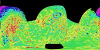
This has been an extremely interesting project but the results are fairly interesting. I have 'discovered' a highly degraded impact basin similar in size to Tirawa - it's not obvious in the source images. There are some interesting features near Tirawa's antipode that I think are real but I'm not completely convinced - if real they may or may not be associated with Tirawa's formation. I will post more details plus some crater depth measurements once I finish the DEM sometime in April.
There are a few frustrating gaps in the DEM, the biggest one in the north polar region for obvious reasons and another one near longitude 0. The latter may get filled following a nontargeted flyby in June 2010 (assuming Rhea gets imaged the way I want ).
I will probably be posting a flyover movie before mid-April and possibly a rotation movie as well. Meanwhile I'm posting two test renders:
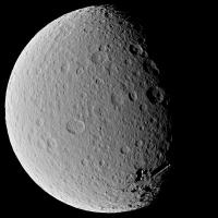
|
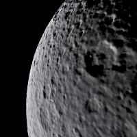
|
The first one is from 3100 km from Rhea's center and has a FOV of 30°. The other one is from an altitude of 340 km and has a 45° FOV. I didn't drape a texture map over the DEM. The DEM is global so this wouldn't look realistic. The first one looks fairly realistic even though it is very obvious that it is computer generated. The second one reveals that the resolution of the DEM is several times lower than the resolution of the source images - they typically have a resolution of ~1 km/pixel.
And as previously noted: There's more to come in the not too distant future. And an interesting decision: Which satellite to do next.
Posted by: Hungry4info Mar 31 2009, 01:05 AM
Wow. For a second, I didn't realise that the first image of Rhea wasn't a Cassini image. Very nice work!
I don't suppose you could release this in a way that would be usable in Celestia, could you?
Posted by: ElkGroveDan Mar 31 2009, 01:29 AM
Bjorn, I am speechless. Warn me before you post the final product as I'm likely to pass out. Needless to say, however long it took you was time very well spent.
Posted by: Bjorn Jonsson Apr 7 2009, 11:56 PM
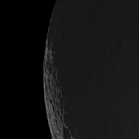
Just for fun here is a test image that represents a 'work-in-progress' version showing Tirawa and its 'twin' to the southwest:
|
Looks decent despite the seams, except for the 'noisy' area below and slightly right of center. This represents low quality data because of the high solar elevation angle and rather small difference in the viewing geometry of the two source images I used for this area. I'm hoping for better data from a June 3, 2010 nontargeted flyby.
Once all of the seams visible in this image have been removed from the DEM I have almost completed work on it until better data and gap fill data arrives.
Posted by: tedstryk Apr 8 2009, 09:58 AM
That is amazing! I do have to say that it looks like Rhea is under construction here (as if panels are being put in place!).
Ted
Posted by: Phil Stooke Apr 8 2009, 11:28 AM
Fantastic work on the DEM!
However, the second basin has been seen before, by both Cassini and even Voyager:
http://www.unmannedspaceflight.com/index.php?showtopic=1676&st=45
http://www.lpi.usra.edu/meetings/lpsc2001/pdf/1074.pdf
Phil
Posted by: Bjorn Jonsson Apr 8 2009, 09:51 PM
Thanks - I had forgotten the second basin was seen by Voyager but needless to say it is conspicuous in many of the Cassini images.
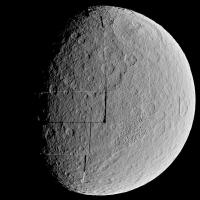
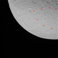
However, the basin I mentioned in the first message of the thread I had 'discovered' is a different one. It is the big one at the center of this image:
|
I'm sure this feature is real and not a processing artifact. The maximum depth of the basin is ~2 km, typically ~1.5 km and parts of it are less than 1 km deep. In contrast, Tirawa's maximum depth is ~5 km (this is a somewhat preliminary number), typically ~3 - 4.5 km and in addition it has a ~10 km high central peak relative to the crater floor. I don't know exactly how accurate these numbers are but they should give a fairly accurate view of the altitude of specific features relative to neighboring features.
This big basin isn't exactly conspicuous in the DEM's source images. This is its approximate boundary (the exact boundary is somewhat indistinct):
|
Finally I should mention that the big gap in the DEM I mentioned previously is visible in the first image. It should be possible to fill this gap following a June 18, 2010 nontargeted flyby. Actually this terrain has been fairly well imaged - the problem is simply lack of stereo coverage (or at least I couldn't find anything useful there for stereo).
Posted by: DrShank Apr 8 2009, 10:08 PM
Nice job!
ive done a similar map on my own, and reported on it at the 2007 LPSC. I found an old degraded basin in the same place and it seems to be real. ive have my own monster project almost done with and will get to this and finish it soon!
cheers
paul
|
Posted by: Bjorn Jonsson Apr 25 2009, 12:27 AM
I have now made some improvements to the DEM and created an experimental animation (about 13 MB) that can be downloaded http://www.mmedia.is/bjj/anim/rhea_dem_flyby.avi.
This animation is much better than I was expecting a few weeks ago and I'm very happy - it is still very obvious that this is computer generated. We start at an altitude of 335 km and end 3500 km from Rhea's center. The field of view is 35°. I recommend full-screen viewing in a dark room (Rhea's nigthside isn't completely black, it is lit by Saturnshine).
The viewing and lighting geometry is carefully selected to ensure that only the highest quality parts of the DEM are visible. Parts of the DEM are of lower resolution and/or are more noisy. They will be revealed in a rotation movie I'll do sometime in the next several days.
Three stills from the animation:
|
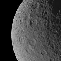
|
|
Posted by: CAP-Team Apr 25 2009, 12:53 PM
Great work!
Is it possible to create a normal map using this DEM?
Posted by: ugordan Apr 25 2009, 04:23 PM
Impressive work as always, Bjorn!
Interesting photometric function you used, its limb-brightening character reminds me of something I can't quite put my finger on. I think it could be far ultraviolet ISS images of the moons which show quite a dependance on solar incidence/look angle, unlike longer wavelength filters.
Posted by: stevesliva Apr 25 2009, 06:04 PM
I was thinking the limb looked pretty sweet, too.
Posted by: Bjorn Jonsson Apr 25 2009, 06:28 PM
I'm using a Hapke function with preliminary values for the parameters. They are not accurate - the limb is too bright, making this look a bit like UV images. The next step is refined photometric parameters (hopefully different for R/G/B) and a global albedo/color map. This is needed to make features like bright craters with rays visible.
Posted by: Bjorn Jonsson May 3 2009, 10:42 PM
Thanks to DrShank's great map I realized that I had omitted two images showing only Rhea's limb. This enabled me to fill most of the gap near longitude 0 but significantly better coverage should still result from the nontargeted flybys I mentioned earlier. DrShank's map also enabled me to verify that a few features I had some doubts about are real.
Following this, and after filling a few small gaps that remained by 'cloning' adjacent data I made a rotation movie: rhea_rotation_s.avi ( 4.44MB )
: 601
rhea_rotation_s.avi ( 4.44MB )
: 601
Compared to the previous movie I'm using a bit different photometric parameters but they are still preliminary.
It's obvious from this movie that the DEM's quality varies significantly although overall I'm happy with it (in the previous movie I took care to show only the high quality stuff ). There is noisy terrain south of Tirawa, rather low resolution near 250°W and small gaps and low quality data near 0°W (terrain near the limb in the source images). Significant improvement should be possible by using imagery from future nontargeted flybys plus data from the February 2, 2009 nontargeted flyby.
The next step is to do a color/albedo map from low phase images.
Posted by: scalbers May 3 2009, 10:54 PM
Very nice DEM and animation Bjorn. I suppose if one has the time (easy for me to say) it would be interesting to produce animations of Cassini flybys, then to show the actual images as they were acquired next to the animation.
Steve
Posted by: Bjorn Jonsson Jun 4 2009, 11:06 PM
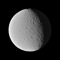
Yet another animation, this time with a color/albedo map draped over the DEM. The map was created from low phase global RGB images and manually modified by removing shadows where they were present. The DEM has not changed but eventually should become better from an aesthetic point of view following manual retouching. And as previously mentioned, there are some nice nontargeted flybys that I look forward to.
Two stills from the animation:

|

|
And finally the animation:
rhea_rot_color_c.avi ( 7.03MB )
: 608The field of view is 35 degrees and the distance from Rhea's center is 3150 km. The photometric parameters have been improved a bit but are not final.
Next stop: Dione.
Posted by: Floyd Jun 4 2009, 11:14 PM
Wow!!! that is really impressive.
Posted by: nprev Jun 4 2009, 11:23 PM
 ..."Stunning" doesn't even BEGIN to describe it, Bjorn!!! Absolutely, positively, heart-stoppingly beautiful!
Posted by: Poolio Jun 4 2009, 11:39 PM
Wow! I am stunned. Speechless. I'll probably never understand how you do something like this, but I will always enjoy the fruits of your labors. (That sentiment actually applies to a great many of you folks around here.)
Posted by: CAP-Team Jun 8 2009, 06:12 PM
Any chance you're going to release these maps for the public?

Posted by: brellis Jun 9 2009, 02:30 AM
This is wonderful work! Amazing how the shadows progress on the deeper craters as they reach the horizon.
Powered by Invision Power Board (http://www.invisionboard.com)
© Invision Power Services (http://www.invisionpower.com)