Printable Version of Topic
Click here to view this topic in its original format
Unmanned Spaceflight.com _ Opportunity _ Cape York - The "Lakelands"
Posted by: Tesheiner Sep 1 2011, 04:30 PM
http://www.unmannedspaceflight.com/index.php?s=&showtopic=681&view=findpost&p=178234. It's time to move on.
Next target? Philosilicates.
-----
Edited on Sep 16 2011.
This thread is dedicated to the exploration of Cape York, starting on sol 2703 when Opportunity left the "rocky garden" and started moving towards Chester Lake.
Posted by: jvandriel Sep 2 2011, 08:27 AM
The Navcam L0 view on Sol 2703.
Jan van Driel
|
Posted by: Tesheiner Sep 2 2011, 11:01 AM
As soon as we move to the east edge of CY, I think the view to Endeavour's far side and the north rim will improve significantly.
Posted by: mhoward Sep 3 2011, 01:43 AM
Sol 2703-2704 Navcam panorama (updated)
http://midnightmartian.com/space/images/MERB2703_2704NavcamLeft.jpg
http://midnightmartian.com/space/images/MERB2703_2704NavcamRight.jpg
http://midnightmartian.com/space/images/MERB2703_2704NavcamAnaglyph.jpg
Posted by: Tesheiner Sep 3 2011, 09:05 AM
I just finished reading http://www.planetary.org/news/2011/0901_Mars_Exploration_Rover_Update.html (by Salley Rayl @ TPS); a great reading with a lot of goodies, as usual. I'm copying here a reference about our next waypoint:

A really rough surface, isn't it? Easy to understand why they didn't use the RAT on it.
Posted by: fredk Sep 3 2011, 06:23 PM
Some good quotes about the future in that update:
From Squyres:
Posted by: Stu Sep 4 2011, 10:21 PM
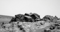
Some goodies from today...
|
|
Drive direction?

|
Rather yummy-looking outcrop/ridge?
|
A(nother) beaten up breccia of a mongrel of a rock...
Posted by: mhoward Sep 5 2011, 02:37 AM
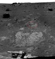
In order, labels are: "HBC" (whatever that means; maybe "B" is for Bedrock?), "Kirkland Lake", and "Marion".
In the second one I assume "Kirkland Lake" is the largest feature. We've seen it from the side. The triangularish rock on the left in that one must be "Trailbreaker", then, I guess. (As Tesheiner figured. Of course, keep in mind this is still partly guesswork.)
Posted by: Phil Stooke Sep 5 2011, 02:58 AM
To any Canadian, HBC can only mean Hudson's Bay Company... though maybe to a MER driver it means something different... did Oppy lose a hubcap?
Phil
Posted by: Sunspot Sep 5 2011, 06:10 AM
So what might these 3 plus billion year old clay deposits actually look like to Opportunity's cameras? Are they likely to be dramatically obvious or very subtle perhaps indistinguishable from their surroundings?
Posted by: mhoward Sep 5 2011, 02:24 PM
This may help visualize where we are: http://midnightmartian.com/space/images/MERB2703-2706View1_labels.jpg http://midnightmartian.com/space/images/MERB2703-2706View2_labels.jpg
Posted by: Tesheiner Sep 5 2011, 06:08 PM
Definitely yes!
Looking at Tisdale 1 from this perspective I think it's almost clear it has the same "bright top" as Tisdale 2. There were some pancams of it planned to be taken thisol (2707) and I believe those shots should confirm it.
Would like to know the meaning of "HBC" too; I presume it is related to the bright patch of bedrock to the right of those three rocks. Actually, the rover moved to that area some hours ago. Map update in a minute.
Posted by: jamescanvin Sep 5 2011, 07:45 PM
Here is the HBC mosaic:
http://www.nivnac.co.uk/mer/index.php/b2706
Posted by: ugordan Sep 5 2011, 08:06 PM
Nice!
Posted by: mhoward Sep 5 2011, 08:21 PM
Sol 2707 Navcam http://midnightmartian.com/space/images/MERB2707NavcamLeft.jpg http://midnightmartian.com/space/images/MERB2707NavcamRight.jpg http://midnightmartian.com/space/images/MERB2707NavcamAnaglyph_far.jpg
http://midnightmartian.com/space/images/MERB2707PositionView.jpg
Posted by: Jam Butty Sep 6 2011, 01:30 AM
'Kirkland Lake' from the south,
pancam flicker gif, sol 2706
|
Posted by: marsophile Sep 6 2011, 03:54 PM
I'm thinking that without the mini-tes, it might be difficult to distinguish them. Now the loss of the MTES starts to hurt.
Posted by: Stu Sep 6 2011, 10:16 PM
Ooh, pretty view...

|
Posted by: fredk Sep 8 2011, 02:57 AM
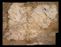
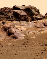
I love the crazy lustre of the bedrock in the latest pancams - Chester Lake perhaps?
http://qt.exploratorium.edu/mars/opportunity/pancam/2011-09-07/1P368674572EFFBN00P2394L7M1.JPG?sol2709
How much information does the lustre give the geologically minded here about the rock? Can't wait to see this in colour...
Posted by: vjkane Sep 8 2011, 03:47 AM
I think it's going to awhile before the geologists get tired of this place
Posted by: NickF Sep 8 2011, 04:00 AM
fredk's "Chester Lake" L2-5-7 pancams. Others can undoubtedly do better 
|
Posted by: brellis Sep 8 2011, 06:01 AM
I continue to be stunned and amazed, not only at the imagery coming from Oppy, but the gorgeous processing y'alls are doing. Thank you so many times!
Posted by: Stu Sep 8 2011, 02:11 PM
"Chester Lake" looks very interesting. Ridges of harder, darker rock jutting up out of lighter rock... cracks... pits... it's got it all...
|
(sharpened and colour-enhanced to bring out subtle features on the rock)
Full size version: http://roadtoendeavour.files.wordpress.com/2011/09/v2.jpg
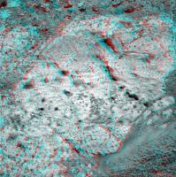
Posted by: ngunn Sep 8 2011, 02:49 PM
Some of the shiny bits do look like knobbly inclusions of a harder material, but others look like flat quadrilaterals bounded by
the surface crack patterns, as if they could be places where thin flakes of weathered surface material have recently broken away. I wonder if any of the loose flakes lying around the vicinity can be matched up shape-wise to individual shiny patches on the rock?
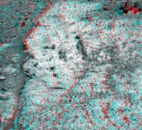
Posted by: jamescanvin Sep 8 2011, 10:13 PM
Chester Lake in 'false but trying' and 'stretched to within an inch' colours.
http://www.nivnac.co.uk/mer/index.php/b2709
http://www.nivnac.co.uk/mer/index.php/b2709
Fascinating...
Posted by: walfy Sep 8 2011, 11:47 PM
Right side of Chester Lake:
|
Posted by: walfy Sep 9 2011, 12:00 AM
Left side of Chester Lake:
|
Posted by: mhoward Sep 9 2011, 03:40 PM
Sol 2710 Navcam panorama http://midnightmartian.com/space/images/MERB2710NavcamLeft.jpg http://midnightmartian.com/space/images/MERB2710NavcamRight.jpg http://midnightmartian.com/space/images/MERB2710NavcamAnaglyph.jpg
Posted by: mhoward Sep 9 2011, 05:18 PM
Just for fun
|

|
Posted by: ngunn Sep 9 2011, 07:22 PM
That's so much better than my paper version, thanks!
And while I'm at it huge thanks to everyone for all the wonderful rockscapes and Endeavour vistas on this thread.
Posted by: Phil Stooke Sep 10 2011, 02:02 AM
A circular version of mhoward's nice new panorama.
Phil
|
Posted by: dilo Sep 10 2011, 05:23 AM
Marvellous, guys! Starts to recall me Spirit Odyssey on Husband hill!
Posted by: jvandriel Sep 10 2011, 12:08 PM
Another Navcam L0 view taken on Sol 2710.
Jan van Driel
|
|
Posted by: fredk Sep 10 2011, 03:09 PM
Some comments on Chester Lake (and a false colour (?!) pancam view) http://opportunityendeavour.blogspot.com/2011/09/story-and-context.html "Paraphrased" from Squyres:
It is something entirely new, or SOS ("Same Old Sulfates")? This is our first major Noachian target, so let's make it count.
Posted by: Matt Lenda Sep 10 2011, 04:12 PM
Had me fooled, too. I asked myself that all day.
The EOSs and SOWG meetings are particularly cryptic these days; these guys talk and head and shoulders above my comprehension!
-m
Posted by: marsophile Sep 10 2011, 05:50 PM
Maybe it is the orbital images of that locality that look Noachian rather than that specific rock.
Posted by: Phil Stooke Sep 10 2011, 06:45 PM
The new target is Salisbury... my home town! - I mean the one in Wiltshire, not one of the Salisburys in the colonies.
Phil
Posted by: Stu Sep 10 2011, 07:13 PM
Another magnifcent view...

|
Full size version here: http://twitpic.com/6iynsp/full
Posted by: serpens Sep 11 2011, 01:22 AM
It looks like an impact breccia, integral to the weathered rim of a crater that pre-dated the Meridiani sediment formation. Could it be anything other than a Noachian construct?
Posted by: Bill Harris Sep 11 2011, 09:28 AM
True that, Serpens. The geomorph of this area is more complex and convoluted than we we assume or possibly can imagine. It's like standing on a small chunk of the Canadian Shield and figuring out depositional environments with a handlens and a Brunton.
Ah, the comparative simplicity of seven years on the playa may have spoilt us...
--Bill (almost giddy with anticipation over impending MI's and APXS)
Posted by: SteveM Sep 11 2011, 03:37 PM
Could some of you tell a non-geologist what kinds of questions the new detail we're encountering might answer. What more will we learn about the history of Mars -- besides the overly mentioned issue of water.
Steve M
Posted by: Phil Stooke Sep 11 2011, 06:11 PM
We don't know all the details, but it seems the sulfate and blueberry rocks of the plains we've just left were formed in a relatively brief period in the middle of Martian history. Water was there, and probably very salty and foul-tasting water! - not very pleasant for life. These rocks at Cape York are much older, and may have formed in very different conditions. What we hope to learn is, what were those conditions? Warm or cold? Reducing or oxidizing conditions? Acidic or alkaline? Lots of water or only a bit? Water in the ground, or melting out of overlying snow? So we would expect evidence of water, but it's the environmental conditions that are most important.
Phil
Posted by: Bill Harris Sep 11 2011, 08:57 PM
That is it, exactly. When a rock like basalt weathers, in the presence of water, it breaks down into clay minerals (the phyllosilicates in the news) and various anions and cations ("minerals" dissolved in the water). The type of clays, and other weathering byproducts, is dependent on the ionic makeup of the water to begin with, as well as the temperature and whether the environment was oxidizing or reducing. By looking at the weathered zone on the hill, we can tell what the conditions were way back then.
--Bill
Posted by: Stu Sep 11 2011, 09:29 PM
Thanks Bill and Phil, that's a really clear, really useful explanation of the significance of this place. Much appreciated.
Posted by: ngunn Sep 11 2011, 10:00 PM
There is the complication of deciding whether any clays that may be found were formed by weathering of the basalts before the impact or after brecciation and deposition on the crater rim. It's not an easy puzzle.
Posted by: Jam Butty Sep 12 2011, 01:05 AM
Stoughton and Ridout,
flicker gif pancam sol 2711...
|
Posted by: jvandriel Sep 12 2011, 08:40 AM
Thanks Phil and Bill for that explanation and SteveM for the question.
Now I, as a non-geologist, understand what is going on on Mars
besides driving and taking pictures and measurements.
That is the purpose of this website, or not ?.
jan van Driel
Posted by: Fran Ontanaya Sep 12 2011, 02:49 PM
That pancam caught a dark embedded pebble in the lower left.
Posted by: Floyd Sep 12 2011, 03:59 PM
Can anyone place the background of this image. Where is it relative to Chester Lake? Is it in one of the pancam or navcam panoramas?
Posted by: Tesheiner Sep 12 2011, 05:19 PM
It's above it. The latest navcam mosaic (from sol 2710) misses the peeble by just a few cm or so but the one taken at the previous site, before the final approach to Chester Lake, catches it. I highlighted the peeble and the whole area on this partly mosaic from sol 2707.
|
Posted by: mhoward Sep 12 2011, 05:38 PM
Actually they took a left Navcam image at the same time as the color Pancam image, and it fits in with the Sol 2710 panorama.
http://mmb.unmannedspaceflight.com/MERB2710_2713_Sept11_2011_View.jpg
Full 360 degree panorama with single color image:
http://mmb.unmannedspaceflight.com/MERB2710_2713_Sept11_2011_combined_medium.jpg
http://mmb.unmannedspaceflight.com/MERB2710_2713_Sept11_2011_combined.mov (5 MB)
Edit: Improved the images a bit.
Posted by: SteveM Sep 12 2011, 07:17 PM
Sorry I didn't get back earlier to thank Phil and Bill fore the helpful answers (doing some remodeling and those who've been there know what that does to free time).
Steve M
Posted by: Stu Sep 13 2011, 10:42 AM
"Brett Lake'...

|
"Larder Lake"...

|
"Kinojevis"

|
Posted by: mhoward Sep 13 2011, 02:03 PM
Time once again to play http://mmb.unmannedspaceflight.com/MERB2710_2714_mmb_view.jpg (Sol 2710-2714). See Stu's post for names; the bottom one with the NASA logo is "Salisbury 1".
Posted by: neo56 Sep 14 2011, 12:00 AM
"Larder Lake"...
"Kinojevis"
Beautiful pics Stu ! Have Opportunity reached the first phyllosilicates rocks ?
Posted by: Astro0 Sep 15 2011, 05:02 AM
As there were a lot of variations on the same image of Opportunity's IDD for 9/11, it was worth moving them all to their http://www.unmannedspaceflight.com/index.php?showtopic=7071.
NB: mhoward's panoramas which included the IDD shot were not moved as they incorporated the wider view of Oppy's current location.
Posted by: charborob Sep 15 2011, 01:02 PM
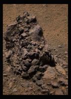
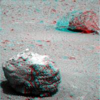
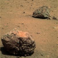
Nice pair of rocks (names?).
|
The one in front makes me think of a block of slag (just an impression, not very scientific, I know).
Posted by: mhoward Sep 15 2011, 02:14 PM
'Biscotasing' and 'Halliday'. Unknown which is which, but I would guess from left to right.
Posted by: Phil Stooke Sep 15 2011, 02:49 PM
A composite of the current pan plus names. I am finding it hard to go back to sites from years ago and recover the names used at the time - even the PDS interface to names is clumsy and incomplete. I would like to encourage our merry band to continue to document names as we have been doing here.
Phil
|
|
Posted by: mhoward Sep 15 2011, 02:54 PM
Good idea. I might have a go at that myself, later; it's kind of a relaxing hobby. If only I could easily get subframe images onto my panorama.
Posted by: neo56 Sep 15 2011, 05:53 PM
Biscotasing and Halliday in color, on sol 2716.
|
Posted by: neo56 Sep 15 2011, 06:03 PM
And Larder Lake, on sol 2715.

|
Posted by: walfy Sep 15 2011, 06:49 PM
Biscotasing rock super gif:

|
Posted by: Sunspot Sep 15 2011, 09:06 PM
It looks like it might fall apart if you touched it.....and it kind of looks like a meatball
Posted by: Jam Butty Sep 15 2011, 10:23 PM
Stoughton, sol 2716 L456
|
Interesting looking light-coloured rock embedded in that block of brecia.
Posted by: monty python Sep 15 2011, 11:09 PM
According to Scott Maxwell's Twitter site, the IDD will brush and APXS - mossbauer the site with a grind on friday. But later says their is a lively debate on getting on with moving.
If they use the limmited resource of the grind, I bet a mossbauer is likely. And with the time that would take would a large super pan or super res shot take place in light of the not so hot tau?
Also the grinder doesn't have many grinds left. If it quits could you use a turning wheel with the rover in place like they did early in the mission to partly decrust rock -without hurting the wheel or contaminating the rock with wheel stuff?
Monty.
Posted by: Matt Lenda Sep 16 2011, 02:33 AM
If they use the limmited resource of the grind, I bet a mossbauer is likely. And with the time that would take would a large super pan or super res shot take place in light of the not so hot tau?
Monty.
I very much doubt we would risk that. We are extra cautious when it comes to using our wheels! Though the RAT seems to be in great health anyways, limited grinds notwithstanding.
-m
Posted by: NickF Sep 16 2011, 02:43 AM
My interpretation of the 'Larder Lake' L2/5/7 pancam images, Sol 2715.
|
Posted by: Tesheiner Sep 16 2011, 06:37 AM
Ok, just finished splitting the "Cape York" thread. This new one starts with the approach to Chester Lake (and the Lakelands) and should be the current one 'til they finish sniffing and exploring this area. All posts related to Tisdale, Odyssey and previous sites should be posted on the other proper threads.
Posted by: jvandriel Sep 16 2011, 08:54 AM
Nice Pancam view on Sol 2715.
Jan van Driel
|
Posted by: jamescanvin Sep 16 2011, 09:02 AM
That is the start of the Endeavour pan. Those 5 will be joined by 10 more tomorrowsol, and hopefully more next week. All in L257 colour.
Posted by: Bill Harris Sep 16 2011, 02:37 PM
This is strange.
Over the last couple of weeks I've had serious problems trying to get the MI's to match up with the Pancams for location images. Today I think I found out why.
One of the oddities of the way MI's are presented is that the images are inverted compared to the "normal" Pancam (and other cameras) view. No problem, as standard procedure I invert the MI's after download so that they match the orientation of the Pancam images. Today I was attempting to match the latest MI's with the latest Pancams and I saw that the MI's are now being transferred in the same "correct" orientation as the Pancam images.
Has anyone else noticed this? I need to go back and check the past few week's MI's, and check also at Hortonheardawho's Flicker site (who frequently makes MI location charts).
--Bill
Posted by: djellison Sep 16 2011, 03:11 PM
Remember - the MI could be oriented different way depending on where the IDD is placed. This isn't a post-production issue, so to speak.
Posted by: NickF Sep 17 2011, 02:36 AM
Another part of the Endeavour L2/5/7 pan, sol 2715.

|
Posted by: brellis Sep 17 2011, 05:48 AM
NickF -- that's quite a tilt in your sol 2715 post. Are we already looking at hills in the distance?
Posted by: Stu Sep 17 2011, 08:37 AM
Back from battling Daleks in London to find...
|
|

Posted by: jvandriel Sep 17 2011, 11:21 AM
The Panoramic L2 view of Endeavour Crater.
Taken on Sol 2715.
Jan van Driel
|
|
Posted by: brellis Sep 17 2011, 01:29 PM
Beautiful Pan von Jan! Now I understand the tilted perspective in NickF's clip.
Posted by: NickF Sep 17 2011, 01:42 PM
Indeed, the rover is on a c. 10 degree slope at the moment.
Here's the straightened version of my previous composite.
|
Posted by: fredk Sep 17 2011, 02:28 PM
The numbers we've seen indicate tau has dropped a fair bit in the last month or so, but with these new pancams we can directly see how much the transparency has improved in the last few weeks. Compare these frames from 2679 and 2718 looking across to Iazu:
http://marsrovers.jpl.nasa.gov/gallery/all/1/p/2679/1P366016008EFFBM00P2384L2M1.JPG
http://qt.exploratorium.edu/mars/opportunity/pancam/2011-09-17/1P369487946EFFBN19P2285L2M1.JPG?sol2718
Posted by: mhoward Sep 17 2011, 03:35 PM
According to the database it's the "Endeavour 1" mosaic, parts 1 and 2. Once it's down, the L257 color version should be really something. The color parts we've seen are already amazing. Lot of work to put it all together, though.
http://mmb.unmannedspaceflight.com/MERB2715_2718_Pancam_Endeavour1_L2_cropped.jpg
Posted by: fredk Sep 17 2011, 05:09 PM
Thanks for the stitches, guys - this is a stunning view. Lots of colour variation too - the L2's are showing very different details than the L7's.
Here's a long baseline anaglyph from sols 2679 and 2718. The lighting is pretty different between the frames, and the stereo effect is pretty extreme for Solander point, so this may be one for the hard-core anaglyphers out there. Some nice structure on the inner slope of Tribulation, though.
|
|
Here's a cross-eyed version for those using stereo photo maker or the like:
|
|
Posted by: Matt Lenda Sep 17 2011, 05:18 PM
Heads up for a RAT hole sometime tonight!
-m
Posted by: eoincampbell Sep 18 2011, 01:58 AM
Thanks to everyone for stitching the latest thrilling pan... what an amazing place this is...
Posted by: jvandriel Sep 18 2011, 11:19 AM
If you want a new background on your computerscreen
here is the one.
Jan van Driel

|
Posted by: Juramike Sep 18 2011, 12:16 PM
"Just wait for me in the car while I go run up that hill for a sec..."
Posted by: Bill Harris Sep 18 2011, 06:42 PM
Nice preliminary RAT MI's this morning, and I was able to get things straightened out and produce a couple of IDD location images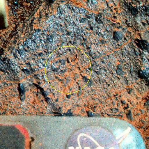
http://i142.photobucket.com/albums/r91/wilga_photo/Oppy/L257-1P368674511EFFBN00P2394L2M1--annot.jpg
Other images at the P'bucket site linked below.
--Bill
Posted by: Eutectic Sep 19 2011, 12:03 AM
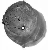
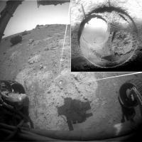
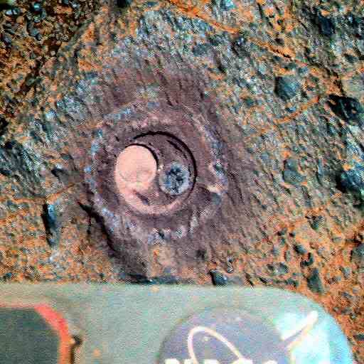
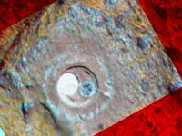
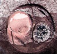
Post-RAT imagery.
|
Posted by: Zeke4ther Sep 19 2011, 01:07 AM
Wow! That rock was awfully soft...look at all of the powder.
Posted by: elakdawalla Sep 19 2011, 02:15 AM
I'm glad the old girl wasn't given anything too difficult to chew
Posted by: Greg Hullender Sep 19 2011, 02:39 AM
Is there a nice summary somewhere of what instruments are still working and what sort of science Opportunity is still able to do? Obviously the pictures alone are still spectacular, but I'm wondering what else is still working.
--Greg
Posted by: djellison Sep 19 2011, 02:45 AM
Pancam - Fine, and less dusty than it has been
MiniTES - Bust
IDD - Azimuth joint bust - can position instrument along a vertical plane, not full 3D space.
APXS - Fine
MI - Fine
RAT - Fine ( but obviously, teeth are consumed to near death )
Mossbauer - VERY VERY tired. We're > 10 half-lives into it - so integrations that would have taken 6 hrs could technically take > 6 months. A good integration now would involved several weeks.
Posted by: elakdawalla Sep 19 2011, 02:52 AM
I can't help but think that if I were the MER team I'd aim for a likely looking rock in early November, do some documentation, put out the Moessbauer, and take a nice long Thanksgiving & Christmas holiday while it integrates!
Posted by: fredk Sep 19 2011, 03:37 AM
From http://opportunityendeavour.blogspot.com/2011/09/day-in-life-bsols-2719-2721-secret.html
Super res?
Posted by: CosmicRocker Sep 19 2011, 04:01 AM
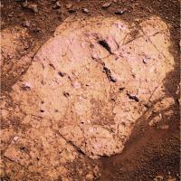
That rock was incredibly soft. I wasn't expecting that. In retrospect, perhaps I should have expected it. The outcrop is worn down just as flat as the surrounding Meridiani sandstones, so why wouldn't we expect it to be soft?
Posted by: stevesliva Sep 19 2011, 05:23 AM
Or dust. Depends on how you see it. They do gamely keep checking it.
Posted by: marsophile Sep 19 2011, 05:59 AM
Does that mean it is not basaltic?
Posted by: djellison Sep 19 2011, 06:30 AM
Check the documentation for the MER Analysts Notebook.
For example - Sol 2261-2267 MER B Downlink Report
*except the Mini-Thermal Emission Spectrometer (MTES) which has experienced a failure. Investigations into the Mini-TES failure are ongoing.
or
Sol 2281-2287 MER B Downlink Report
later, you will just find
Or from the excellent : http://www.planetary.org/news/2011/0901_Mars_Exploration_Rover_Update.html
Or going back further in time
http://www.planetary.org/news/2011/0430_Mars_Exploration_Rover_Update_Spirit.html
This month, the Mini-TES exhibited more anomalous behavior. Specifically, it failed to draw power. A functioning Mini-TES should draw 200-250 milliamperes up to about ¼ amp, according to Nelson. "We're not seeing that current draw," he said.
That would seem to suggest that the Mini-TES is simply not turning on, or that something somewhere between the instrument and motor control board has failed. Although the instrument investigation is continuing, the Mini-TES remains, Nelson said, "effectively out of commission."
It is, as I said.... bust.
Posted by: serpens Sep 19 2011, 07:40 AM
Indeed. Remember Clovis rock - a Spirit RAT in 2004 - image below? Looks a bit softer than Opportunity's last grind. But this is a breccia, probably suevite and the weathering susceptibilities of the constituent elements are different to the Moh's scale resistance to abrasion.
http://marsrover.nasa.gov/gallery/press/spirit/20040820a/sol_a217_rathole_plano-A223R1_br.jpg
Posted by: jvandriel Sep 19 2011, 09:40 AM
Mi cam Sol 2719.
Jan van Driel
|
Posted by: vikingmars Sep 19 2011, 10:21 AM
Yes : great idea Emily and and at a place where the global view of Endeavour is terrific and where a 360° pan can be taken (i.e. somewhere near the top of Cape York), and -even better if possible- with low sun and nice long shadows to enhance the features
Posted by: Bill Harris Sep 19 2011, 10:38 AM
That is what I initially thought but decided that the surface looked "too glassy" to be deeply weathered. I imagine that the actual criteria for hardness of the rock would be Oppy's RAT engineering telemetry, such as the current draw or the grind time of the operation, and not amount of cuttings.
--Bill
Posted by: fredk Sep 19 2011, 03:24 PM
"Poor man's" superres from the 2720 Tribulation/Solander 16 L6 frames:

|
As usual, this isn't a true superres - all I've done is resample to double res, then register and average, to (dramatically) reduce jpeg noise.
Posted by: Matt Lenda Sep 19 2011, 03:31 PM
I'd agree with Scott Maxwell's opinion on such a thing...
"*Yawn*."

-m
EDIT:
Jan van Driel
|
|
Haha, I love the multiple shadows in there. Very clean merge!
Posted by: MarkG Sep 19 2011, 05:42 PM
Jan van Driel
|
|
Is there enough control in the arm and enough brush left to sweep out the grind debris? I remember that the brush bristles were a bit "cattywumpus".
Posted by: djellison Sep 19 2011, 05:49 PM
--Bill
They have indeed done just that - infer hardness based on RAT performance. If you remember back in the early days - a berry was picked up mid-grind as a spike, and later caused the RAT to stall.
Posted by: Jam Butty Sep 20 2011, 01:28 AM
Tribulation L257
sols 2718 & 20

|
Posted by: CosmicRocker Sep 20 2011, 05:44 AM
While fresh basalt is a pretty hard rock, the softness doesn't rule out basalt. If basalt is weathered or altered, especially in the presence of water, it can become quite soft. I think the light color of this rock pretty much eliminates it from having an overall basaltic composition, though the dark, angular rock fragments embedded in the breccia could very well be basalt. The minerals of basalt are very dark in color.
The dark blocks of a different breccia lying on top of the nearby hill look very much like basalt. The geology here is fascinating. I can't wait for Opportunity to explore more of Cape York and send back more pictures.
Bill: You are right about the RAT telemetry being the ultimate measure of the rock hardness, but it will be a while before that data will be available...and I won't know how to interpret it when the data is released. My comment on the rock's softness was based solely on depth of the grind. We know that the remaining life of the RAT is a resource the team is trying to conserve for the most important scientific targets, so I would be surprised if they instructed the rover to grind away on this first target without limits. To me, it looks like other soft rocks they have ground into.
Posted by: CosmicRocker Sep 20 2011, 05:54 AM
sols 2718 & 20
I really appreciate that you post important information like the sol and the filters used in your images. Some people often neglect to provide that information, and that makes it difficult for others to follow up.
Posted by: Bill Harris Sep 20 2011, 09:14 AM
For sure. The surface we are looking at is the product of 3 bln years of deposition, weathering and erosion and each rock fragment tells a story. Some of these rocks are ejectite'd impactites. 
There are going to be many profound papers generated from the data at this site.
I'm sure that they know precisely what the "hardness" of the rock is from the engineering data, which we in the p'nut gallery are not privy to. Just as they have an idea what mineral is represently by every "RGB color" we see in the Pancams. Even with seriously degraded IDD parts, geologists have made do with scratch plates, acid bottles and rock hammers and calibrated "TLAR"eyeballs for decades for mineral identification.
The first thing they are doing on Sol-2722 ("today") is making a FHazcam assessment of the RAT teeth("frhaz_RAT_bit_check_subframe") and getting ready to do chemistry ("front_haz_idd_apxs_doc").
Having snagged the post-grind Pancams of Salisbury1 from the 0:35 Data Express and done my preliminary oooh-ing and ahhh-ing, I'm hitting the sack again... yawnn
--Bill
Posted by: Fran Ontanaya Sep 20 2011, 10:18 AM
Could they be obsidian in a perlite matrix?
Posted by: Bill Harris Sep 20 2011, 11:19 AM
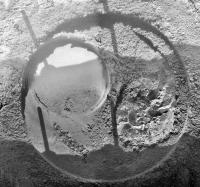
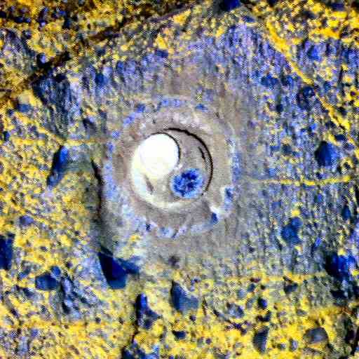
Couldn't get my beauty rest, I ended up working on the new images. Note the implication of different mineralogy-- the RAT cuttings are purplish or gray, instead of the usual ochre or blue.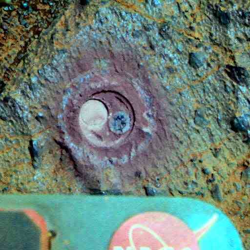
--Bill
Posted by: mhoward Sep 20 2011, 03:10 PM
Here's an attempt at a color flicker pair. L257, R21(synthesized green), animated GIF, anaglyph
|
|
|
|
Posted by: djellison Sep 20 2011, 03:30 PM
All that different to earlier grindings?
http://marsrovers.jpl.nasa.gov/gallery/press/opportunity/20040305a/16-jb-03-hole1-B041R1_br.jpg
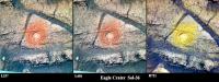
Posted by: Bill Harris Sep 20 2011, 05:51 PM
Good example. This is the first RAT done in Eagle Crater on Sol-36.
More difference than 21km and 2+ Billion years...
--Bill
|
Posted by: Phil Stooke Sep 20 2011, 06:26 PM
It would be interesting to compile a sequence of images showing the RAT holes at different dates - right now we are getting that small circle inside the larger one, which was not seen in the first hole. When did it start looking like that?
Phil
Posted by: centsworth_II Sep 20 2011, 07:14 PM
My guess is, that's what happens when the two grinding wheels are not rotated around each other.
"Two grinding wheels rotate at high speeds. These wheels also rotate around each other at a much slower speed so that the two grinding wheels sweep the entire cutting area."
http://marsrover.nasa.gov/mission/spacecraft_instru_rat.html
Posted by: M@! Sep 20 2011, 07:47 PM
It may be a result of the damage to the RAT brush. At the very least it's not new. I see similar circle-within-a-circle patterns in http://www.unmannedspaceflight.com/index.php?showtopic=6852&view=findpost&p=170958 from Sol 2513.
Posted by: Bill Harris Sep 20 2011, 08:08 PM
The circle-within-a-circle is how the RAT operates. The carbide cutters are on an arm that moves around in a cyclical motion. You can see how it works in the images at the Athena site (the link to the "Honeywell Robotics" RAT site is dead):
http://athena.cornell.edu/the_mission/ins_rat.html
After the grind is done the brush is supposed to clear away the cuttings but the brush is kaflooey...
You can get an idea of how well it works from this animation:
http://images.spaceref.com/news/2004/rover.armspin.mov
--Bill
Posted by: Phil Stooke Sep 20 2011, 08:22 PM
Interesting responses! But that's why it would be interesting to collect RAT images throughout the mission to see how the holes have varied in appearance. Anyone? (I don't have time right now)
Phil
Posted by: Matt Lenda Sep 20 2011, 08:40 PM
We are thinking about doing that sometime soon. There was considerable debate among the SOWG whether or not the extra rubbage in there would contaminate the exposed core of the rock. We've got ground in the loop to look at some things tomorrow and may try another brush+APXS.
Soonest we can count on boogeying on out of the Chesterlake area is... Friday? We'll be hitting nominal sols soon and it'll be day in day out for two weeks.
-m
Posted by: Stu Sep 20 2011, 10:09 PM
Phil
This page might be useful for you, Phil...
http://marswatch.astro.cornell.edu/pancam_instrument/images/merges/merges.html
Posted by: Phil Stooke Sep 20 2011, 10:57 PM
... and even more useful for the person who makes the comparison image! Actually I think straight pancam images would be easier to use for this.
Phil
Posted by: Stu Sep 20 2011, 11:00 PM
Ok, just thought it was worth a look for you. I'll have a delve into the archives tomorrow.
Posted by: Phil Stooke Sep 21 2011, 12:12 AM
It's a great site, Stu! I just don't have time to look at this question right now - up to my ears in Itokawa problems.
Phil
Posted by: Bill Harris Sep 21 2011, 02:55 AM
AFAIK, the next known important site is in the area of the CRISM phyllosilicate signature around that summit crater ~300m NE. And, of course, important sights seen along the way...
--Bill
Posted by: Jam Butty Sep 21 2011, 03:54 AM
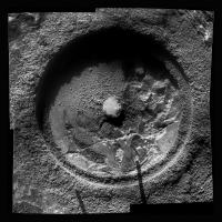
A composite pancam/microscope image of the recent RAT hole in 'Chester Lake'
pancam L456 sol 2721
microscope sol 2719 (jvandriel's image from here)
|
Posted by: CosmicRocker Sep 21 2011, 05:13 AM
That's certainly a possibility, Fran. I didn't think of that, but I suppose it could be obsidian in perlite. I don't have a lot of experience with volcanic glasses, but the few times I saw such rocks in the field, the obsidian inclusions were typically rounded and not angular like these. That's an interesting suggestion that I will have to consider. I have to wonder, though, would we expect to see glasses in rocks that are so old, or would they have devitrified after all this time, perhaps leading to the formation of clay minerals?
Posted by: Bill Harris Sep 21 2011, 02:05 PM
I'm not familiar with that mineral, but AFAIK perlite is a volcanic glass (obsidian) that is hydrated and when heated, it expands producing a light weight, light-colored material. From the few pictures I've found it looks like a medium-greyish rock with a pearly luster. The diagnostic feature is that it expands greatly when heated.
What have we seen here that looks like perlite? And how was it identified? It would be good to find a perlite since that would imply an impact melt that was hydrated because it was created from a wet parent material.
Enquiring minds need to know...
--Bill
Posted by: tanjent Sep 21 2011, 04:53 PM
"Perlite" (I assume it's the same stuff) is a soil conditioner commonly used in hydroponic gardening. It's very soft - you can grind it between your fingers, and I think even under today's martian environmental conditions, exposed perlite would have long since eroded away from just the rarefied effects of the wind. I suppose there might be deposits of it buried underground dating from the noachian era, but very unlikely that it could be mined with just a RAT. (I'm no geologist - please let me know if this is a completely different substance I am thinking of.)
Posted by: ngunn Sep 21 2011, 08:22 PM
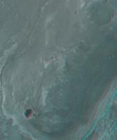
A break from mineralogy: the cyclops is crying.
http://qt.exploratorium.edu/mars/opportunity/pancam/2011-09-21/1P369487087EFFBN19P2285L2M2.JPG
The crater seems to collect and 'focus' the downslope streak.
Posted by: Phil Stooke Sep 21 2011, 09:19 PM
Great view!
Phil
Posted by: Bill Harris Sep 21 2011, 09:24 PM
Ah is a gee-ologist but 40 years outta school. "Perlite", as far as I can tell, is a manmade product created by heating a hydrated obsidian to some 1600*F where the volcanic glass softens and the entrained water causes it to"foam up" and expand. And as far as I can tell, hydrated obsidian, the mineral, is also (and possibly informally) called "perlite". I don't think that the manmade commercial soil additive occurs in natural deposits anywhere. However, I wonder if the "hydrated obsidian" could refer to an impact melt created from a water-saturated source material. With certain temperatures/pressures/timeframes I can see this as "possible".
Over time, a glass can weather or degrade from a "glassy" form to a "crystalline" form, a process called "devitrification". In obsidian samples, this is seen as "snowflake obsidian". It could devitrify into a smectite or a clay mineral, but I've seen no suggestions at Salisbury1 of devitrification of the impact melt.
And, picking nits, obsidian is a siliceous rhyolytic glass which is not compatible with the mafic (silica-poor) basalts we see in this region of Mars, so we're looking for glass of basaltic composition, such as a tachylite.
Why get worked up this much about a volcanic glass? It may well be the best way to do a comparative study of the creation and weathering of impact melt (impact glass) on Mars.
--Bill
Posted by: NickF Sep 22 2011, 01:52 AM
Here's an L2/5/7 composite from sol 2718, part of the 'big pan'. There are some subtlety fascinating variations in colour coming through.
|
Posted by: CosmicRocker Sep 22 2011, 04:48 AM
At this point, even though it appears likely, we really don't know if we are seeing impact melts or not. But the point I was trying to make regarding devitrification was that after about 4 billion years any volcanic glass that may have existed should have had ample time to devitrify. Have you ever seen a Precambrian glass?
I understand that we are expecting to see basaltic rocks here, but we don't "know" that all of the rocks here are mafic. Some silicic volcanics would probably be a very exciting discovery on Mars, but I was simply acknowledging Fran's observation that the current science target does resemble http://v1.cache3.c.bigcache.googleapis.com/static.panoramio.com/photos/original/19894773.jpg.
We have to remember that we are among the first geologists from our planet to have had the opportunity to explore the rocks of another. We should expect to be surprised as often as we find things that are familiar.
N.B: The perlite used in hydroponics and soil conditioning may be derived from the rock known as perlite, but it is not the same thing.
Posted by: Bill Harris Sep 22 2011, 09:19 AM
Good points, Tom.
I think we are seeing glasses (impact melts) here-- we certainly see impact breccias with many angular clasts that have a vitreous appearance. If not from Endeavour, then from any of the several other impacts evident in the area.
We don't see that many Precambrian glasses here on Earth. But PC rocks here have been buried, metamorphosed, tectonicizated and generally weathered in a warm and wet oxidizing environment. On Mars, they've been in dry storage for megamillenia (by comparison), so I think that a glass would stay glassy much longer. But this is the first example we've been of the type, so who knows...
Google in usually your friend, but in this case was a tangle of ambiguity. Most of the hits for "perlite" were for the garden soil additive with loose pointers towards the volcanic glass mineral. And I've not seen my copy of Dana for decades...
What was the source of that "perlite" photo you showed? I tried to back my way out through the "bigcache.googleapis.com" URL but I got 404'd.
Nice new Pancams of site "Chester Lake2" this AM, and the tracking web suggests more MI's upcoming with soem APXS work. Then, I've heard, Oppy'll be moving on by the weekend.
These are interesting times...
--Bill
Posted by: jvandriel Sep 22 2011, 10:02 AM
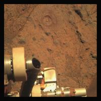
Sol 2722 Front Hazcam.
The RAT is still working.
Jan van Driel
|
Posted by: centsworth_II Sep 22 2011, 01:14 PM
http://www.dicalite.com/perlite_ore.htm from a company whose claim to fame is owning both ore mining and processing facilities:
"Perlite Ore is formed by magmatic ("liquid rock") processes, usually in "domes",that over geologic time periods entrap water into the Perlite matrix. The mechanism through which this occurs is not completely understood, however, it is this entrapped water which gives perlite ore it's unique ability to "Pop" under proper high temperature conditions."
Posted by: jamescanvin Sep 22 2011, 10:10 PM
As there are still missing data I haven't tried too hard to perfect this, but the the view is so astounding that I can't keep this preliminary version to myself! 
http://www.nivnac.co.uk/mer/index.php/b2715
James
Posted by: Stu Sep 22 2011, 10:34 PM
Absolutely gorgeous James! I've been trying to make the same view but can't get the ends to behave, or the colours to all blend, so I've gone with the central section and trying to bring out subtle shades and features in the central dome...

|
Posted by: Phil Stooke Sep 22 2011, 11:37 PM
Both are spectacular! Thanks.
Phil
Posted by: brellis Sep 23 2011, 12:21 AM
wowie! What a spectacular view.
Q- do we see haze in the distance? It looks so much like the San Fernando Valley, my brain computes an earth analog :-)
Apologies if this has already been discussed, I searched for "haze" in this topic and the Cape York thread.
Posted by: CosmicRocker Sep 23 2011, 06:35 AM
I did an image search for "perlite obsidian" and found some photos of obsidian in perlite. That image I linked to came from http://www.panoramio.com/photo/19894773.
Posted by: Bill Harris Sep 23 2011, 11:01 AM
Ah, good search. Being an imprecise name, I didn't use "perlite" with "obsidian" in the same search term.
Did dig up a couple of references via the image search:
The hydration and alteration of perlite and rhyolite
http://jgs.lyellcollection.org/content/166/5/895.abstract
and
--Bill
Posted by: rschare Sep 23 2011, 01:14 PM
I don't know a thing how you all get the pictures and "driving data" from (I think) exploritorium. But, is there a way to see the results of the APXS that we're doing on Chester Lake from that data? Be great to know what the results of the Zinc levels and discuss it here.
Posted by: Phil Stooke Sep 23 2011, 02:11 PM
No, sorry! You have to wait for the APXS team to announce something.
Phil
Posted by: fredk Sep 23 2011, 02:31 PM
APXS = real science! There's no way the team would release the important stuff like that before they had a chance to publish the results themselves.
The pictures have relatively little science value (at least it's unlikely anyone would scoop the team and publish something based on the pics alone). That's why we get to see the pictures in real time.
Posted by: elakdawalla Sep 23 2011, 04:34 PM
I think Jim Bell would beg to differ, as would most of the geologists on the team
 However it's true that pictures alone rarely form the basis of a scientific paper. In any case the scientific value of the pictures is degraded by them being piped to the Web without calibration, auto-stretched, and JPEG-compressed, and one would be an idiot to write a scientific paper based on these raw JPEGs. Although I don't know for certain, I'd hazard a guess that uncalibrated APXS data would be uninterpretable.
Posted by: serpens Sep 23 2011, 11:31 PM
True. It would be next to impossible to identify mineral makeup from pancam using the raw images from the web over only 11 wavelengths. Deconvolving spectra would be a huge challenge and would require data not available such as the CCD and electronics temperatures when the image was taken to enable proper calibration. The calibration target chips included hematite and goethite powder and were conditioned with UV exposure before launch, but after all this time could well have suffered from UV deterioration. I would assume that Jim Bell would have ensured laboratory spectra from expected minerals /combinations over expected temperature ranges using the actual deployed pancam to provide comnparative baselines. Certainly out of the amateur league.
But the Pancam and MI provide a huge amount of visual data and it is the correlation of all data that enables the production of the absolutely outstanding science papers we have become used to.
Posted by: Stu Sep 25 2011, 05:24 PM
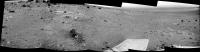
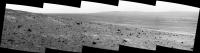
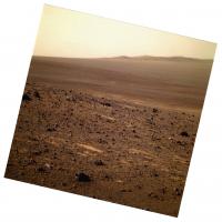
Three years ago today (if I've read the dates right), on sol 1661, Oppy paused in her trek around the edge of Victoria Crater, stopping just in front of a small crater called "Sputnik", and we all marvelled at the incredible vista before her: the great crater's capes and bays stretched away on all sides, its crumbling cliffs and dust-rippled floor all fighting for our attention. Oppy sent back three pictures of "Sputnik" which, when joined together, looked like this...

|
On the far horizon were a few barely-there bumps - the hills marking the rim of a huge crater called "Endeavour", an enormous hole in the ground that was so far away that even thinking of trying to drive to it was foolish; such a journey would take years, years, and require the rover - which had already exceded all expectations - to cross a vast area of unforgiving desert. Oppy wouldn't get even halfway, surely...
Three years later...
|

Posted by: Phil Stooke Sep 26 2011, 01:21 PM
I'm getting dizzy! Hope we don't fall in...
Very nice pic, Stu.
Phil Stooke
Posted by: Matt Lenda Sep 26 2011, 03:44 PM
Love that VE'd pic!
Good thing you're keeping up on the blogging. Things have been crazier than hell at JPL.
I've got a few posts in the queue! I promise!
-m
Posted by: Hungry4info Sep 26 2011, 08:36 PM
Opportunity has been imaged on Cape York by MRO.
http://www.universetoday.com/wp-content/uploads/2011/09/ESP_024015_1775_crop1.jpg.
Posted by: Matt Lenda Sep 27 2011, 03:04 AM
Mossbauer is down on the re-brushed Salisbruy-1 target and integrating away as we speak...*
Yay!
We plan to sit here for at least the remainder of the week, with MB measurements in the planning loop to determine when we like what we see. Some more magic from the team will be streaming out in the next 2 weeks as we hit the Nominal (planning 5 days/week) planning cycle!
-m
*EDIT: Well, in about half an hour... :
Posted by: jamescanvin Sep 27 2011, 03:02 PM
Have you got confirmation of this Matt? 2728 looks like another runout from the tracking data.
Posted by: Stu Sep 27 2011, 03:02 PM
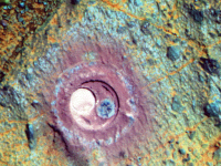
Stitched/sharpened/sprinkled with magic dust view of the Salisbury hole...
|
Posted by: Bill Harris Sep 27 2011, 03:50 PM
Wonderful post-brush MIs from Sol-2728-- they provide more tantalizing insights into character and properties of the rock and cuttings at Salisbury.
--Bill
Posted by: Stu Sep 28 2011, 02:24 PM
Dunes on the floor of Endeavour...

|
Posted by: ElkGroveDan Sep 28 2011, 03:04 PM
Sounds like the title of a Moody Blues album.
Posted by: jamescanvin Sep 28 2011, 08:54 PM
The missing piece came down, so as promised I've had another go at this...
http://www.nivnac.co.uk/mer/index.php/b2715v2
James
Posted by: eoincampbell Sep 29 2011, 02:11 AM
An evocative masterpiece, congrats...
Posted by: Matt Lenda Sep 29 2011, 01:35 PM
Haha... I spoke too soon. There was a hiccup at the DSN literally 10 minutes after I posted! 2728 never made it up.
-m
Posted by: Bill Harris Sep 29 2011, 03:53 PM
Heh, so the best laid plans of RATs and MERs...
Worked up an IDD location montage for Salisbury this morning. Interesting to see from the Pancams what Oppy's been grinding upon.
http://i142.photobucket.com/albums/r91/wilga_photo/Oppy/salisbury_IDD_loc.jpg
--Bill
Posted by: ngunn Sep 29 2011, 05:25 PM
...gang after clay.
Posted by: Phil Stooke Sep 29 2011, 07:48 PM
Oh, that's very good!
Phil
(to clarify, I mean both of the above two posts)
Posted by: helvick Sep 29 2011, 11:23 PM
Possibly the best double act comment pair on the site, ever...
Posted by: stevesliva Sep 30 2011, 01:01 AM
Call it the Burns formation.
Posted by: Bill Harris Sep 30 2011, 10:17 AM
"Say goodnight, Gracie..."
Supposedly Oppy will be doing a MB integration at Salibury for a few days, but in the pipeline are images of the Next Drive Direction (P2397) and a super-res image set at Sutherland Point (presumably the post-C.York target).
--Bill
Posted by: Matt Lenda Sep 30 2011, 01:34 PM
Yeah, there's a veritable fork in the road today and Monday. They are possibly going to simply "rinse and repeat" the last few sols' plans of MB integrations, since we get two "free" sols of it when we make the weekend plans on Fridays. There seems to be agreement that we shouldn't drive away just yet. Monday is likely going to be a "clean up and drive off" day.
-m
Posted by: Bill Harris Sep 30 2011, 02:21 PM
Agreed, the in-place bedrock nearby appears to be similar to Salisbury so Oppy's done all that can be done at this location. They might want to zap the RAT hole with the MB for a longer integration time, but that's all. They need to work their way up-hill to the next outcrop on the way to the CRISM clays near the "summit crater". Geologically there was so much happening here that moving a short distance up in the section will put us in a whole 'nuther sequence of events.
--Bill
Posted by: jvandriel Oct 1 2011, 06:52 PM
The L2 Pancam view on Sol 2732.
Jan van Driel
|
|
Posted by: James Sorenson Oct 1 2011, 07:58 PM
Some really facinating topography here
|
|
Posted by: fredk Oct 1 2011, 08:17 PM
I see you added some shear to the images to "flatten out" the anaglyph, James. Did you do that by hand, or using some automated routine?
Posted by: Phil Stooke Oct 1 2011, 09:24 PM
That's quite the anaglyph! I wouldn't want to try driving over it if that was the real topography...
Phil
Posted by: Stu Oct 1 2011, 10:28 PM
Colourised sol 2732 panorama...

|
Full size version on my RtE blog later.
Posted by: djellison Oct 1 2011, 11:04 PM
It's important to differentiate between color and colorized. That mosaic, Stu - is color. Taking a Navcam pan and tinting it orange would be colorized.
One creates something with more information than the component parts alone, the other, technically, reduces it. Yours - importantly - is the former.
Posted by: Stu Oct 1 2011, 11:11 PM
You're right, my mistake. Long, not particularly clean day at work, knackered, meant to say colour.
Fascinating place, Cape York, isn't it? And we were worried it would be a flat, featureless "Nothing to see here, move along" kind of place. Looking forward to looking back down on it from halfway up Tribulation one day...
Edit: 3D crop view...

|
Posted by: James Sorenson Oct 2 2011, 05:08 AM
I used the warp transform in Photoshop to manually align the red channel (left eye) with features in right eye.
Posted by: Phil Stooke Oct 2 2011, 12:00 PM
Ah - that is why the result has some dramatic wavy distortions in it.
Phil
Posted by: Bill Harris Oct 2 2011, 01:41 PM
Here are some images I've worked up whilst musing the delivery of a set of "Next Drive Direction" Pancams last week.
First off is a recent HiRISE image of Cape York showing Oppy at the Chester Lake outcrop. Annotated, it shows Oppy as R, possible site "Skead Kirkland Lake" as 1, possible site "BostonCreek LarderLake" as 2 and an unidentified rock pile seen on the horizon of the drive direction panorama as 3. The dashed yellow line is simply the observed "trend" in the outcrops seen in the aerials-- the strata on the rim of crater Endeavour are tilted or uplifted and dip towards the northwest. Features aligned along this trend direction are likely of a similar age and, although there may be differences in the rocks, they are linked by time of formation. Strata downhill will be older and strata uphill will be younger in age. As a general rule, more-or-less.
http://i142.photobucket.com/albums/r91/wilga_photo/Oppy/ESP_024015_1775_RED--crop-Next_Drive_Dir_Sol-2730-annot.jpg
http://i142.photobucket.com/albums/r91/wilga_photo/Oppy/1P370627485EFFBN19P2397L2M1-pano.jpg
The outcrop Skead Kirkland Lake is one we've drooled at before and is an interesting-looking exposure. Why is there an unusual purplish iridescent sheen to the rock? I'll guess it's a weathering phenomenon, which is the important step in turning silicate rocks into clays. Wouldn't hurt to have a closer look-- not necessarily a full IDD session, but a series of close-in Pancams would be peachy.
http://i142.photobucket.com/albums/r91/wilga_photo/Oppy/L257-1P370716206EFFBN19P2398L2M1.jpg
Next would be the outcrop BostonCreek LarderLake **. Along the trend-timeline as Skead, but why is it different? Look at the number of beds seen in this outcrop. Whereas most of the rocks seen here have been a massive impact breccia (apparently), this unit is more finely bedded, which implies different depositional processes were at work here. And just over the hill is the "summit crater" with the CRISM clays scattered about, so "Boston" is a important puzzle piece. I tried to merge the color information with the grayscale detail, but couldn't get it to work out, so here are two similar but different views.
http://i142.photobucket.com/albums/r91/wilga_photo/Oppy/L257-1P369207402ESFBN19P2540L2M1-1.jpg
http://i142.photobucket.com/albums/r91/wilga_photo/Oppy/1P370627552EFFBN19P2397L2M1--crop-enh.jpg
--Bill
** "BostonCreek LarderLake" has been named Shoemaker Ridge (after Gene Shoemaker, a planetary geologist).
Posted by: mhoward Oct 2 2011, 03:51 PM
Can't wait to get over that rise.
http://mmb.unmannedspaceflight.com/MERB2715_2732PancamAnaglyphL2R2.jpg
http://mmb.unmannedspaceflight.com/MERB2715_2732PancamL2_360x32_m.jpg
Posted by: Bobby Oct 2 2011, 03:56 PM
Short Question regarding Coloring of Photos.
Is there any site out there that shows how Nasa or JPL converts the Black and White images into true Color Images?
Thanks.
Posted by: djellison Oct 2 2011, 04:21 PM
From the Cornell Pancam team with multiple references:
http://pancam.astro.cornell.edu/pancam_instrument/projects_1.html
That's as close to " how Nasa or JPL converts the Black and White images into true Color Images" as you will find.
This is more of a laypersons discussion of it:
http://www.highmars.org/niac/education/mer/
Posted by: fredk Oct 3 2011, 02:34 AM
From the latest http://www.planetary.org/news/2011/0930_Mars_Exploration_Rover_Update.html some news about Chester Lake:
And discussion about the coming winter:
Posted by: vikingmars Oct 3 2011, 09:55 AM
Well : let's have a nice look at Cape Tribulation : here is a quick merge between super hi-reshttp://pancam.astro.cornell.edu/pancam_instrument/images/Sol2720B_P2544_superres_4x.tif
image and color image from Sol 2721... Some more geological delights to come... Yum ! Yum !

|
Posted by: brellis Oct 3 2011, 06:14 PM
Question about an image posted in the http://www.planetary.org/news/2011/0930_Mars_Exploration_Rover_Update.html: what is the feature running from top left to bottom right? If it's not the rim of Endeavour, is it another crater rim, or some kind of lava flow? A shoreline from the watery past?
Apologies in advance if this has been discussed; searching continues to baffle! 
Posted by: marswiggle Oct 3 2011, 06:57 PM
And as an accompaniment with the above image, a slightly enlarged (120%) and sharpened anaglyph of the southern half of Cape York, all the way to the phyllosilicate crater - complete with Oppy! (Hopefully answering brellis's question too. )
|
Posted by: brellis Oct 3 2011, 06:58 PM
Sifting through the wonderful PS update, it seems to be the SW edge of Cape York. Correct?
edit: thanks wiggle!
Posted by: brellis Oct 3 2011, 07:11 PM
Another question: is the bright feature in the distance in this pic the eastern edge of Cape York? Why is it bright? Okay, that was two questions!
edit: I referred to it as the Ventura Freeway in the context of a crater the size of the San Fernando Valley, CA. A bright feature running through the middle-right of the pic
ADMIN EDIT : Removed embedding of image - it was 4500 pixels across.
Use a link and/or thumbnail
http://www.db-prods.net/marsroversimages/Opportunity/2011/Sol2681-pancam.jpg
Posted by: serpens Oct 3 2011, 10:55 PM
It's a terrace or bench around CY and other rim remnants that seems to delineate the change between the hematite concretion bearing sulphate sediments and the old rim material. We crossed the bench with some haste and currently can only hypothesise from our armchairs over the underlying cause.
Posted by: eoincampbell Oct 4 2011, 02:00 AM
The "Ventura Freeway" from your link appears to be a stretch of bright dunes skirting Endeavour's enormous mound.
Google Mars suggests these dunes are some 3km in the distance...
Posted by: ElkGroveDan Oct 4 2011, 03:04 AM
That's Sherman Way, Brad. The Ventura Freeway is barely visible in the lower right corner.
Posted by: brellis Oct 4 2011, 05:35 AM
Thanks, Dan. I always get lost in the SF valley, lol
Posted by: Tesheiner Oct 4 2011, 08:35 PM
Moved a few posts to start the new thread "http://www.unmannedspaceflight.com/index.php?showtopic=7081".
As usual, posts related to the upcoming destination Shoemaker Ridge, there. Posts related to Chester Lake, still here.
Posted by: Bill Harris Oct 4 2011, 09:06 PM
Technically, we are still in the "Lakelands" area when we get to the next stop "Skead Kirkland Lake ". From a lithologic and staratigraphic standpoint "Skead" and "Chester" are quite similar, whereas "BostonCreek LarderLake" (now known as "Shoemaker Ridge") is indeed quite different than anything we've seen.
No big deal, just noting a technicality...
--Bill
Posted by: serpens Oct 5 2011, 01:51 AM
The PS update noted that Steve Squyres mentioned that Chester Lake "has sort of a basaltic composition. It does not have a zinc enrichment like we saw at [Tisdale 2]."
The published APXS comparative graph for Tisdale 2 showed elevated Zn and Br but did not address Cu. I think that enhanced Br is consistent with basaltic glass but If Cu was also elevated it would possibly indicate past, hot hydrothermal activity. If not then possibly a cold seep or basaltic weathering (plagioclase?). Does anyone have any idea of the Cu level?
Posted by: Bill Harris Oct 5 2011, 01:42 PM
I've not seen any of the details of the chemistry, but this will likely be a hot topic at the next LPSC.
The top of Tisdale which was APXS'd is either a weathered zone and/or has a inherent different chemistry or is a bedding plane/fracture which has a zone of Zn-rich material deposited in it (cold-water hydrothermal). That "weathered" unit has a distinctive light-ochre color is evident in other exposures along Shoemaker Ridge and should be examined further on the traverse to the "summit crater". I intuitively think of this yellowish colour as generally "limonitic", which could include almost anything, actually.
Remember, the original, deep crust here is from not only a warmer and wetter Mars, but a Mars with a hotter amd more mobile/active crust/mantle. The mantle of that era had more hotspots and plumes and there was extensive tectonic activity.
This primeval crust (Ur-crust) has since been pounded, mixed and blended into an impact breccia by countless impacts, and it has, among other things, has a much higher surface:volume ratio than rock and can be much more reactive to chemical weathering, weathering in the presence of water.
In a way, this is a glimpse at what the Earth may have been like in Hadean times, with tectonic cycles starting and bio-processes just beginning.
Exciting times, then and now.
--Bill
corrected (strikethrough)
Posted by: Phil Stooke Oct 5 2011, 02:10 PM
Meridiani on the edge of the Tharsis uplift? That's a bit of a stretch!
Phil
Posted by: Juramike Oct 5 2011, 02:26 PM
best Mars uplift pun ever...
Posted by: Bill Harris Oct 5 2011, 02:42 PM
Oops, you're correct-- I was thinking of something else.
--Bill
Posted by: Nix Oct 5 2011, 03:03 PM

Posted by: Stu Oct 5 2011, 09:39 PM
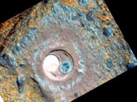
Colour view of the RAT hole...
|
Powered by Invision Power Board (http://www.invisionboard.com)
© Invision Power Services (http://www.invisionpower.com)