Printable Version of Topic
Click here to view this topic in its original format
Unmanned Spaceflight.com _ Opportunity _ To the Cape!
Posted by: djellison Mar 31 2008, 12:16 PM
"Hey folks! Im on-duty with Opportunity this week and its going to be pretty exciting. We are in the process of driving the rover over to the wall of Cape Verde to study the layers of rocks there in much greater detail. I will be posting updates all week with the spectacular new pictures that we should be receiving. Stay tuned, its going to be a pretty cool week!"
Thanks for the update Ryan : http://martianchronicles.wordpress.com/2008/03/31/opportunity-is-going-to-the-cape/
I wonder how close they'll get. I think no closer than the height projected from it's base ( i.e. 45 degrees )
Posted by: nprev Mar 31 2008, 12:34 PM
Rock on!!! 

Posted by: Stu Mar 31 2008, 12:45 PM
Woohoo!! Go get 'em Oppy! About time our gal lifted her eyes off the ground and looked up again. 
Posted by: jvandriel Mar 31 2008, 01:00 PM
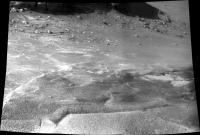
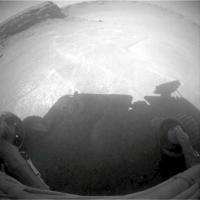
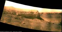
The view in the drive direction on Sol 1484.
Taken with the R2 Pancam.
jvandriel
|
Posted by: SpaceListener Mar 31 2008, 03:00 PM

- Because of the Sun's rays : Mmm... The wall is on the North side. Now Mars is heading close to the solicite, hence Mars' tilt is close to 23.5 and the Sun will rise on the South-East toward to South-West side and I seems that there will not have any shade close to the wall of Cape Verde in all day. (I am not very sure on this, I invite someone to correct me on that part).
- Risk of any some loose material from wall? In spite of the fact there has winds, the rock and terrain are already firm except if there will be some Marsquake.
- Sandy surface due to the deposits from the wall of Cape Verde. Yes, I see some deposits close to the wall but I am not able to precise about its measurements.
Why do you think that Opportunity won't be closer than the distance of the height of wall?
Posted by: djellison Mar 31 2008, 03:44 PM
Restricted visibility for Mars Odyssey communications. You would probably be taking a 1/3rd off total downlink if you brought the local horizon to 45 deg elevation (given that the spacecraft will appear to move slower nearer the horizon, thus more of the session, and thus the data, is sent at the lower elevations. )
Doug
Posted by: ngunn Mar 31 2008, 04:28 PM
I'm probably missing something very simple here, but how long does it take to take a photo? Why can't they do short in-out maneuvers for the close-up snaps, backing out each time to a better location for sunbathing and data transmission?
Posted by: ilbasso Mar 31 2008, 08:19 PM
The problem would be if something unexpected happened that aborted the drive-away, anything from wheel slippage to a 'safe mode' event. That could potentially strand Oppy in a very bad place and the situation could deteriorate rapidly if there wasn't enough sunlight or ability to 'see' the orbiters.
Posted by: climber Mar 31 2008, 08:29 PM
When I sew the title of this new topic (I din't notice it was in Oppy section) I thought : I do not remember of any launch scheduled at Cape ...Canaveral !
After last week news of nearly shutting the rovers down...it's even a much better new !
Posted by: ngunn Mar 31 2008, 09:06 PM
A finite risk, certainly, but maybe manageable. I guess you'd have to do repeated stabs to and fro along the same track going a little further in each time, with the back-outs at the far end being slightly downhill (which they probably would be anyway). I doubt if the total daily insolation anywhere (in fine weather) would be as bad as it was out on the plain during the dust storm, and if you're just edging cautiously out of trouble as opposed to sending lots of data you don't need that much relay time.
If it's the only way to address a major science objective some risk is maybe worthwhile?
Posted by: CosmicRocker Apr 1 2008, 04:42 AM
Thanks, Ryan, for the heads-up on this week's plans.
With regard to how closely Opportunity might approach the cliffs of Cape Verde, I think the local geomorphology also limits the places where Oppy is likely to tread. I would guess that the toe of the talus slope surrounding Cape Verde is a boundary beyond which this rover is unlikely to stray.
Posted by: djellison Apr 1 2008, 07:37 AM
"We're hoping to get close enough to reach out and touch the face of this cliff,"
Squyres, in the TPS Rover update for March.
Mr conservative here got it wrong.
Posted by: Tesheiner Apr 1 2008, 08:33 AM
Great news IMO!
(I was planning to post the exact same piece of info. Doug, you beat me.)
"Opportunity roved the first 5.5 meters (18 feet) of the journey to Cape Verde on Sol 1484 (last Thursday, March 27, 2008) and followed that with another 5 meter (16.4-foot) drive on Sol 1486 Saturday (March 29, 2008)"
Next drive is planned for sol 1489. Images should be down in less then 24h.
Posted by: climber Apr 1 2008, 10:50 AM
So, this is the "surprise" SS talked about a few weeks ago! I like it
Posted by: fredk Apr 2 2008, 12:53 AM
I like it too! And can't believe the "reach out and touch" line. At first I thought: "April fools?"
Based on the blog report, here's my estimate of the target location (enhanced and cropped from a pan posted by CosmicRocker):
|
I can understand the drooling going on contemplating that layering!
Posted by: Stephen Apr 2 2008, 02:40 AM
There is a quote from Steve Squyres in the http://planetary.org/news/2008/0331_Mars_Exploration_Rovers_Update_Spirit.html which relates to this:
"'We're hoping to get close enough to reach out and touch the face of this cliff,' Squyres said Friday. There are a number of things that make that 'kind of scary,' he said. 'One is that there is a very steep and rocky slope right below the cliff and those are always difficult to maneuver on.'"
======
Stephen
Edit: I might add there one or two other tidbits about the Cape Verde adventure in that planetary.org page people might want to check out.
Posted by: dvandorn Apr 2 2008, 03:30 AM
Well... after the number of times I have suggested that Squyres and company might well decide to trundle over to the rock face at Verde, and the equal number of times I've been told that it'll *never* happen, I feel good about the plans right now... 
-the other Doug
Posted by: glennwsmith Apr 2 2008, 04:06 AM
"Here's an obvious scenario that better minds can critique: we will descend hugging the clockwise cliff but also at some safe distance from it (lest a rock should become dislodged during the next wind event or daily thermal cycle and fall on the solar panels), occasionally turning to face it (but still at some safe distance) and using the full reach of the instrument arm to RAT and take micrographs and readings." This from my post of June 24, 2007 starting "The Descent into Victoria" thread, before the sandstorm etc. intervened. As noted, an obvious scenario -- you just have to have a little patience!
Posted by: CosmicRocker Apr 2 2008, 06:14 AM
I liked this SS quotation..."For now, all eyes at Meridiani are on the base of Cape Verde. The stereo images the rover took of this "promontory" from the rim last year show striking layers within the bedrock. "The Pancam image we're going to take once we get into position at the base is going to be just stunning, like nothing you've ever seen," Squyres promised.
I can hardly wait.
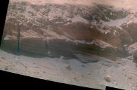
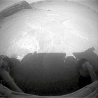
Posted by: jvandriel Apr 2 2008, 02:19 PM
The view in the drive direction on Sol 1486.
Taken with the R0 Navcam.
jvandriel
|
Posted by: fredk Apr 2 2008, 02:54 PM
Testing the surface, I suppose:
http://qt.exploratorium.edu/mars/opportunity/forward_hazcam/2008-04-01/1F260371367EFF8976P1212L0M1.JPG
Posted by: Phil Stooke Apr 2 2008, 11:12 PM
That looks a bit too loose for my liking.
Phil
Posted by: Astro0 Apr 3 2008, 12:38 AM
EDITED - I received some feedback which said... "We are aiming for the triangular piece of layered bedrock that is just to the right of Oppy in your picture. Given the shadows we have seen on images taken on Sol 1489 we might not be able to get so close, but we will try."
OK, Opportunity getting to the base of Cape Verde is just too tempting an image to not start looking at producing an artist's view.
Here's my first second attempt - feel free to chip in with any thoughts (and yes, there are tracks there [which I've also revised, plus a few 'turns in place' tracks]).

|
Revised image based on the advice above.
This will form part of a wider panorama that I am still working on, but the file will be about 25mb when I'm finished.
Here's a small preview.
|
|
Enjoy
Astro0
Posted by: Shaka Apr 3 2008, 01:40 AM
Astro0, Old Matey, Why don't you make a movie 'short' of Oppy puttering around Duck Bay, with the clouds rolling by and a suitable sound track?
On a more serious note, I wonder if someone could do a precise calculation of Oppy's daily solar energy intake in that near-wall position. I fear the result would be disconcerting!
Posted by: glennwsmith Apr 3 2008, 06:22 AM
Yes, the approach looks a little dicey! (How's that for Brit speak?!?)
Posted by: fredk Apr 3 2008, 01:58 PM
We're well past the equinox now, heading towards northern summer. That means that for Oppy, near the equator, the sun has to be on the northern half of the sky all day. It would rise in the ENE, climb up high in the north, and set in the WNW. Definitely not optimal.
Power is one issue, but I wonder what the imaging will be like for shadowed targets. I would think longer than usual exposures would work well. I can't recall any closeup imaging of large shadowed regions from either rover before.
Posted by: djellison Apr 3 2008, 02:43 PM
Oh, hold on - you're right. An equatorial site, during northern summer, will have the sun in the north at noon. At high summer, it would be 25 degrees from zenith. Thus - at noon, mid summers day, a 10m cliff would cast a shadow of about 4.6 metres.
So shadowing WILL be an issue (as indeed, the 4pm navcam image taken a few sols ago shows)
I've got it right this time havn't I? Equatorial sites would have the sun at zenith during northern spring and autumn, and then experience two winters as it were, at northern summer (when a site 25 deg north of the equator has the sun at zenith) and northern winter ( when a site 25 deg south of the equator has the sun at senith)
Doug
Posted by: fredk Apr 3 2008, 04:25 PM
That's right, two very mild winters.
Does anyone know the current subsolar latitude on Mars? Equinox was Dec 10th, solstice is June 25th, so we're past halfway to solstice, but the sun moves northwards much more quickly near equinox, so I'd guess that the sun at noon is currently between 15 and 20 degrees to the north of zenith for Oppy.
Posted by: elakdawalla Apr 3 2008, 05:11 PM
The current subsolar latitude is roughly 20 deg north (this is from Mars24).
Edit: And the current solar elevation for Opportuity is 67.7 degrees.
--Emily
Posted by: helvick Apr 3 2008, 06:00 PM
Sunrise\sunset (on the plains) is at around 5:55AM local mars time at the moment and on a typical Sol the percentages of the the total amount of power generated per hour of each sol is [very roughly]:
12-1PM:15%
1-2PM:13%
2-3PM:11%
3-4PM:7%
4-5PM:3%
5-6PM:1%
(similar numbers apply in reverse to the morning)
My take would be that they could risk being in the shade of the cape for quite a few hours in the evening without it being too risky in terms of overall power loss, being in shade from 3PM would only lose 10-11% of total daily power. It might have a significant impact on thermal management though which is something to bear in mind.
Posted by: Shaka Apr 3 2008, 07:03 PM
Presumably Oppy would be in full shadow all morning, until some time around local noon. Do we have an estimated power input during this shadowed period? Then how many hours of direct sunlight would follow before shadow re-covered it? Can we estimate the southerly tilt of the solar arrays in the near-wall position?
Posted by: climber Apr 3 2008, 08:00 PM
You all love calculations. I love pictures 
 :
:
Let them take pictures of the place they want to go at different hours of the day.
Would be nice, eh ?
Posted by: Shaka Apr 3 2008, 08:27 PM
A start has been made, courtesy of HHAW, for your edification, Climb: http://www.flickr.com/photos/hortonheardawho/2384411265/sizes/o/
However, we need watt-hour numbers to judge the hazard of a given location.
Posted by: Astro0 Apr 3 2008, 10:24 PM
That's some drive ahead of Oppy.
|
Anyone want to pick the route?
Astro0
Posted by: djellison Apr 3 2008, 11:08 PM
left 40
go 10
right 90
go 5
end
MER works like a LOGO turtle right?
Doug
Posted by: helvick Apr 4 2008, 12:05 AM
Judging by Horton's animation it seems that the Oppy's Solar panel deck is effectively already in shadow by 4:30-5:00PM local time. That makes sense as it is at around a 15 degree incline facing away from the setting sun which would correspond to about an hour or so of sunlight.
The shaded zone at Midday seems to be pretty close to the wall so I think that they can probably manoeuvre fairly close in and keep the rover in direct sunlight until ~3:00PM without too much trouble. That would keep the power impact below about a 5-7% reduction from the levels it currently achieves.
Posted by: Astro0 Apr 4 2008, 03:07 AM
Here's a revised version (third) of Oppy at Cape Verde based on some advice and a target.
The path is just my artist's thoughts, not actual. The position of the rover could be in a variety of orientations.
Not science, just art

|
Here's the revised panorama as a thumbnail. Large version will come once Oppy arrives at the Cape.
|
|
Enjoy
Astro0
Posted by: Astro0 Apr 4 2008, 03:12 AM
Based on the above...here's where we could be headed.
Some fantastic layering for Oppy's eyes  and ours
  to bug out on.

|
Cool
Astro0
Posted by: MarsIsImportant Apr 4 2008, 03:32 AM
If Oppy can actually get that close to the Cape safely, then it should be the highlight of the entire mission at Meridiani.
BTW, I would also like to see the rover traverse lower to inspect the deepest layers. I don't know whether that's possible because of the results of that test drive over the dust layer the other day. It looks like Oppy could safely get down to the lower levels, but I don't think it could make it back up the slope along that dust layer. Perhaps it could if it traverse in a Zig-Zag shaped route. I don't know. I hope the MER team finds a way to do it.
Posted by: nprev Apr 4 2008, 03:44 AM
Yeah, I have the same concerns...that deep. loose soil is scary to the nth.
Good thought on the zigzags, though. I'm assuming that the development team at some point determined sideslip coefficients? Would be interesting to know what the limits might be as a function of tilt angle, but they're probably predicated on a more rigid surface...

Posted by: edstrick Apr 4 2008, 08:42 AM
I have not heard *anything* regarding the terrain handling ability of MSL vs MER's. Maximum slope up/down, maximum slope along-slope, soft-sand/dust, etc.
Of course, MSL should be able to handle dust that would be up to or over MER's hubcaps... it's hubcaps are higher!... but what's it's ability in proportionately deeper dust/sand?
Future missions will more and more need greater terrain handling capabilities beyond the baseline level of MSL and MER. Even if a wheel fails, as on Sprit, it should be possible to convert it to a free-wheeling mode, and not terribly cripple the rover on slopes or in soft terrain.
Posted by: Stu Apr 4 2008, 09:00 AM
Going to have to tip-toe through this lot... should be some gorgeous pictures in the days and weeks ahead tho!

|

|
Posted by: Tesheiner Apr 4 2008, 09:29 AM
I'm of the same opinion.
But if you have a look to today's lot of hazcam images, my felling is that the rover drivers don't share our same concerns.
Opportunity drove straight down the slope over the scuff.Here's tosol's (1491) navcam mosaic.

|
Posted by: Doc Apr 4 2008, 12:38 PM
You hav to admit, cape verde is a compelling target. I would be interested to see the layers up close. Particularly those filled fractures. BTW any news on the status of the mini-tes on Oppy?
Posted by: jamescanvin Apr 4 2008, 06:28 PM
This is just the start of the sol 1487 pan but as it shows the region we're all interested in I thought I'd process what is down so far.
http://www.nivnac.co.uk/mer/index.php/2008/04/04/b1487
Click image
James
Posted by: ustrax Apr 4 2008, 07:16 PM
Great blog, great pan! Looks like you'll have a lot of work in the coming days...
Posted by: Stu Apr 5 2008, 11:45 PM
Oh boy we're gonna see some sights over the next few days and weeks... here's the latest view...

|
Posted by: edstrick Apr 6 2008, 05:28 AM
..."...as it shows the region we're all interested in I thought I'd process what is down so far."
I've kept looking at the transition between the cobbly/blocky surface next to the base of the cape and the flatter, but dustier, more mantled surface further from the cape... and keep thinking that slope angle limits permitting...... there's a potentially drivable route...
pant-pant!
Posted by: climber Apr 6 2008, 12:28 PM
James
On the full resolution image we can clearly see the "pavment" under the dust so, I think it'll be driveable.
Posted by: Stu Apr 6 2008, 12:35 PM
Couple more pieces of the puzzle filled in...

|
I know others will do a lot better - by getting rid of those horrible dark lines, for example - but I wanted to have a go... can't resist this low angle lighting...
And a quick 3D of the base of the cliff... looks like there is some interesting terrain over there, some dips and hollows, and some very interesting rocks to look at close-up...

|
Posted by: jamescanvin Apr 6 2008, 05:27 PM
It looks like the 3rd row of the 1487 pan, that is not down yet, is of the sky. So this is a quick go at essentially the finished 6x2 image.
http://www.nivnac.co.uk/mer/index.php/2008/04/04/b1487
Click image
James
Posted by: djellison Apr 6 2008, 06:04 PM
Ryan ( http://martianchronicles.wordpress.com/ ) said that they downlinked all the thumbnails - but then threw away the sky images
They commanded a bigger mosaic than they needed, as it was commanded in the blind before the drive.Doug
Posted by: Ryan Apr 8 2008, 04:21 AM
Yep, didn't want to waste bits downlinking blank sky images. I've posted the full-res false-color (uncalibrated) mosaic in my latest update: http://martianchronicles.wordpress.com/2008/04/07/opportunity-update-sols-1492-1494/
Enjoy!
Posted by: Tesheiner Apr 8 2008, 12:42 PM
There are some fresh pictures on the Exploratorium of the latest move by Opportunity during sol 1495.
The latest significant drive was on sol 1491 (check the route map) and there were two "drive attempts" after that one, on sols 1493 and 1495, both of them resulting on tiny uphill movements.
Have a look to the fhazcam shots from those sols here below (gamma corrected). Don't you think the forward left wheel is sliping and digging in the soil? 
Sol 1491 (original: http://nasa.exploratorium.edu/mars/opportunity/forward_hazcam/2008-04-04/1F260549492EFF8984P1212R0M1.JPG
|
Sol 1493 (original: http://nasa.exploratorium.edu/mars/opportunity/forward_hazcam/2008-04-06/1F260724680EFF8986P1212R0M1.JPG
|
Sol 1495 (original: http://nasa.exploratorium.edu/mars/opportunity/forward_hazcam/2008-04-08/1F260905942EFF8988P1212R0M1.JPG)
|
Posted by: fredk Apr 8 2008, 02:52 PM
On the other hand, we apparently have bedrock not far below the surface here. And the best rover drivers in the solar system at the wheel.
I have to say though that I'm surprized that it appears they intend to take a direct route to the target, over this sandy surface, rather than following the exposed rock to the left (upslope) as far as possible, before heading downslope. Perhaps they've chosen the route with the shallowest slopes.
Posted by: Astro0 Apr 9 2008, 01:16 AM
Animation of Tesheiner's and fredk's observation.

|
This is going to be a long and winding road.
Astro0
Posted by: Tesheiner Apr 9 2008, 01:49 PM
> This is going to be a long and winding road.
Definitely.
Check the latest fhazcam shot from a few hours ago during sol 1496.
|
The original image without any "enhancements" is here: http://nasa.exploratorium.edu/mars/opportunity/forward_hazcam/2008-04-09/1F260992700EFF8990P1213R0M1.JPG
Posted by: mike Apr 10 2008, 03:34 AM
Fear not, they will reach their goal. They must.
Posted by: Tesheiner Apr 10 2008, 07:56 AM
I'm not sure to be correctly interpreting the mobility data from the PCTD but based on that info I calculated the amount of slippage which happened during the driving attempts of last sols. During sol 1493, Opportunity was expected to move some 24cm but actually moved just 7cm; that corresponds to 70% slippage. During sol 1495, she was expected to move 56cm but did only 5cm; 90% slippage. There are not enough data from sol 1496 to calculate any slippage factor.
Opportunity was scheduled to move again tosol (1497). Fingers crossed.
Posted by: djellison Apr 10 2008, 09:34 PM
View from Jan 11th of Oppy in Vic crater.

|
Posted by: climber Apr 10 2008, 09:59 PM
Nice to see her again from the sky. Is this the first pictures from Oppy inside Vicky ?
Something different. I cannot remember whether somebody already pointed out this possibility :
Would be nice to send Oppy there on the way to Cape Verde :
Edit : you'd better click on the image to see what I want to show :
|
Posted by: Stu Apr 10 2008, 10:05 PM
That's really quite moving, seeing Oppy again from above. Brings home just how small she is, but how fearless too...!
Posted by: SpaceListener Apr 10 2008, 10:10 PM
If there is much sleepage, Oppy must move back until the platform and go to closer to Cape Verde and then go down. Not yet I have studied about the degree of transversability of the surface closer to the Cape verde.
Posted by: Tesheiner Apr 11 2008, 07:39 AM
> If there is much sleepage, Oppy must move back until the platform ...
AFAIK that's what they are trying to do, without too much success.
Posted by: Ant103 Apr 11 2008, 01:24 PM
Hi,
Still a long time without make pictures. So, after the beautiful pan of James, I want to show mine 
http://www.astrosurf.com/merimages/Images_opportunity-2008.html#Sol1487
And a little desktop from it, with a new 16:9 format :
http://www.astrosurf.com/merimages/Desktop/ToCapeVerde-Sol1487-desktop.png
Bye,
Damien.
Posted by: Aussie Apr 12 2008, 08:37 AM
Hey Ant, Love your desktops and have had Cape St Mary as my backdrop for a long time. But why such a low resolution for your latest effort?
Posted by: mike Apr 12 2008, 09:23 AM
Thanks for the desktop image.
Posted by: BrianL Apr 12 2008, 02:54 PM
New pics up on exploratorium. Much close scrutiny of the surface by the pancam. Guess I'll await the panel's analysis now.
Brian
Posted by: Ant103 Apr 12 2008, 04:43 PM
Because I was thinking that a lot of people have more 16/9 size screen than traditionnal 4/3. But, If you want, I can make a version with previous resolution I used
.Edit : for those like Aussi who prefer 1280 x 1024 px, here is a version of it : http://www.astrosurf.com/merimages/Desktop/ToCapeVerde-Sol1487-desktop-1280.png
Posted by: Sunspot Apr 12 2008, 07:07 PM
It looks like they may be stuck 
Posted by: Aussie Apr 13 2008, 03:19 AM
Hi Ant,
The 16/9 sizing was great. It was just that a 6kb JPEG doesn't
provide much definition compared to (for example) the 1.7 Meg PNG in your latest 4/3.
Posted by: Tesheiner Apr 13 2008, 10:06 AM
Another attempt to free the rover from the trap (I'm wondering on a name for it...) was executed on sol 1499.
The wheels were commanded to drive for about one meter but Opportunity had a net move of less then 10cm, making for more than 90% slippage.
Posted by: fredk Apr 13 2008, 04:47 PM
(He ducks, expecting to have ruffled many feathers...)
[For non-native Englishers out there, quackmire = quagmire + quack (the sound an English duck makes!)]
Seriously, though, at least some of the other wheels seem to be on pretty firm ground (right rear especially). And it won't take too many 10cm drives to get completely back on firm ground. But this certainly raises questions about getting to the base of the cliff...
Posted by: Stu Apr 13 2008, 10:41 PM
Nice detail visible, even from this far away...

|
Posted by: Aussie Apr 14 2008, 03:13 AM
Quackmire. I think that will stick.
But the question is raises is not about access th the cliff, but rather why they chose to drive back across the excavated holes instead of around them. Or did they intend to go back to do an MI on the scuff and overshot through miscalculation of the slippage going downhill compared to the initial uphill withdrawal drive?
Posted by: Tesheiner Apr 14 2008, 08:31 AM
Are you sure?
Unless my eyes are playing me a trick it looks like the right-rear wheel (left on the images) is not even touching the ground but is floating.
Posted by: BrianL Apr 14 2008, 11:49 AM
What sort of physical situation can cause a rear wheel to come off the ground in this system, and is such a situation possible where it is?
Brian
Posted by: djellison Apr 14 2008, 11:57 AM
The middle wheel digging in will do that quite easily.
Doug
Posted by: jamescanvin Apr 14 2008, 12:07 PM
If you compare the latest rhaz with some from a few sols ago you can see that the right rear has 'moved up' significantly. So it does look like the middle right has started to dig in. Conversely though, it looks like the opposite is happening on the left side which may be a good sign (slightly nervous )
James
Posted by: fredk Apr 14 2008, 03:12 PM

You can see that fairly clearly from an anaglyph:

|
Posted by: Ant103 Apr 14 2008, 03:36 PM
Good catch Fredk. I had the impression by looking at the pictures and I didn't have the idea of the analgyph. And it's clear that the rear-left wheel is above the ground. I'm wondering if it's not the middle-left wheel who is deeply inserted into the ground, and she cause an elevation on rear wheel.
Posted by: Floyd Apr 14 2008, 06:42 PM
The rocker bogie system is great for getting over uneven surfaces as long as they are solid. Unfortunately, there is no way to lock it (or move it) to a 6 flat wheel position for digging out of traps (sort of like 4 wheel drive on a car with differential locked to prevent slipping).
Opportunity's problem, and Spirit getting stuck in the bowl on top of home plate, may cause some re-thinking about rocker bogie designs for future rovers.
-Floyd
Posted by: Stu Apr 14 2008, 07:41 PM
Next section of the latest pan...

|
Posted by: fredk Apr 15 2008, 03:27 AM
From http://martianchronicles.wordpress.com/
Posted by: fredk Apr 15 2008, 03:13 PM
http://qt.exploratorium.edu/mars/opportunity/rear_hazcam/2008-04-15/1R261527492EFF89ABP1314R0M1.JPG

Posted by: djellison Apr 15 2008, 03:19 PM
****
I'll get the low res MER model out when I get home and see what you have to do to the rocker bogie to make that happen. It's more motion than the height of the whole wheel imho.
Doug
Posted by: dot.dk Apr 15 2008, 03:22 PM
Did the IDD stall too?
http://nasa.exploratorium.edu/mars/opportunity/forward_hazcam/2008-04-15/1F261527869EFF89ABP1154R0M1.JPG
Posted by: ustrax Apr 15 2008, 03:52 PM
Looks R-E-A-L-L-Y high to me Doug...
Didn't the ground collapsed on Oppy's front left?...
Posted by: djellison Apr 15 2008, 04:18 PM
Not front left. Middle right.
Doug
Posted by: nprev Apr 15 2008, 05:37 PM
Good grief!!! That ain't right at all!!!
Posted by: Sunspot Apr 15 2008, 06:01 PM
Good Grief...
The middle wheel must be completely covered I should think.
Posted by: ugordan Apr 15 2008, 06:09 PM
What the heck?!?!
Posted by: Tesheiner Apr 15 2008, 07:08 PM
Aside of the "floating" wheel, the rover is clearly tilted to the right!
Just compare the http://qt.exploratorium.edu/mars/opportunity/rear_hazcam/2008-04-15/1R261527492EFF89ABP1314R0M1.JPGwith http://qt.exploratorium.edu/mars/opportunity/rear_hazcam/2008-04-09/1R260992649EFF8990P1312R0M1.JPG.
Posted by: Floyd Apr 15 2008, 07:21 PM
But the good news, looking at those two images, is that we have moved several cm up hill as indicated by the relative position of the triangular rock!
Floyd
Posted by: Tesheiner Apr 15 2008, 08:04 PM
Here're some mobility data associated to today's drive. It was executed in six consecutive steps and each of them was expected to move the rover back some 55cm for a total of 3.3meters. Opportunity moved only 22cm with an average slip factor of 93%.
Fingers crossed!
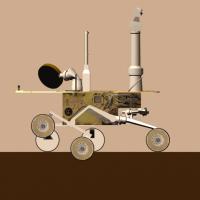
Posted by: djellison Apr 15 2008, 08:31 PM
Actually - it's not as bad as I thought.
My understanding is that the rocker ( the front wheel, thru the diff, to the bogie pivot ) can rotate + / - 20 degrees. The bogie ( the rear two wheels ) can rotate + / -30 degrees. And yes - if they both go max in the same direction, the rear wheel will contact the bottom of a solar array.
BUT - on the upside - I don't think pulling a wheely like we are is as bad as all that after all. Probably about half-buried wheel.
Attached - a low fidelity sim of the RHAZ having a look, the side view of the max bogie tilt, and a movie that shows, I think, the full suspension extent.
Doug
|
|

Posted by: ilbasso Apr 15 2008, 09:16 PM
Excellent illustration and movie, Doug!
Just goes to show what happens when you let things go around on 6 legs, instead of the 3 legs that the God of the Martians intended! H.G. Wells was right, again!
Posted by: nprev Apr 15 2008, 09:45 PM
Well done, Doug, and thank you!
Man, that slip rate from the latest traverse, though...93%? Horrific. I suppose the blueberries are contributing significantly to this. Gee, why didn't the MER designers foresee them?
All humor aside, though, I think that it might well be time to ask some serious questions, as I'm sure the MER team is busily doing. If Oppy goes down there, she really might not be able to get out. The cliff is an extremely tempting and of course scientifically significant target; is this the time to roll the dice?
Hate to say it in a way, but I think the answer is yes. It would be much better to be stranded down there (God forbid) then out on the Meridiani plains with nothing, really, nearby to study. We would've killed to put one of the Vikings right where Oppy's trying to go, after all.
Posted by: Stu Apr 15 2008, 10:17 PM
Having heard Steve S talking on this week's Planetary Radio show, I think it's v v unlikely there'll be any rolling of any dice. He was adamant that VC will NOT be Oppy's final resting place, that she has a lot more work to do outside, back up on the plains. For those who didn't hear the show yet - I say "yet" because everyone should go over to Emily's blog and download the show asap - SS said that they are looking at two possible "campaigns" for Oppy, post-VC. #1: "The Cobble Campaign", where Oppy would re-trace some of her tracks and go back and examine some of the interesting cobbles, stones and meteorites she scooted past in her haste to reach VC. SS said that the "Cobbles" are a very diverse mix, in great contrast to the bedrock seen by Oppy. Some are meteorites, some are ejecta from craters a long way away, and so represent samples of material deeper beneath the surface of Meridiani than seen elsewhere and so far by Oppy. He would like Oppy to go back and take a good close look at these to learn more about the sub-surface of Mars. Campaign #2 would be to go and find some more outcrops of rock and features where water came to the surface.
So, I think that if it comes down to a choice between a glorious game of Rover Roulette and a tactical if grudging withdrawl from VC, I think they'll go with the latter.
Posted by: fredk Apr 16 2008, 12:55 AM
I agree there's work to do out on the plains. Does anyone have a clear idea of exactly what we might learn from an approach to Verde cliff? I mean, we have studied the layers pretty well on our traverse into Victoria so far. But judging from the imagery, the layers they talked about tasting on the cliff are quite a bit lower down than we've sampled so far? Is that all that matters here - getting lower into the layering? Or might they learn something worthwhile by looking closely at the same layers we've already tasted, but now crossing the cliff face?
Posted by: stewjack Apr 16 2008, 01:06 AM
Download
A Mars Rover Update From Steve Squyres ( April 14 2008 ) ( 13.2 MB )
http://s3.amazonaws.com/planetary/radio/pr20080414_64kb.mp3
Stream or Download
Planetary Radio
WEB Page
http://www.planetary.org/radio/show/00000284/
Airdate: Monday, April 14, 2008
Running Time: 00:28:52
Listen: Windows Media | MP3
Jack
Posted by: Aussie Apr 16 2008, 02:42 AM
[quote name='nprev' date='Apr 15 2008, 10:45 PM' post='112364']
The cliff is an extremely tempting and of course scientifically significant target; is this the time to roll the dice?
It would not even be a roll of the dice! Yes they bogged the rover. It happens when you drive over excavated holes, on Mars as on Earth. What I don't understand is that the direction of the drive was down towards the bottom of the scree, not towards the cliffs where there seems to be secure bedrock leading to what seems to be a feasible slope to the cliff face. I still punt on finger problems with distance and slippage when trying to go back and MI the scuffs as I cannot believe that they deliberately crossed the excavations.
It would be helpful if they would do updates when these incidents occur but I guess they have their hands full extracting the rover.
I really can't see the value in examining cobbles of unknown provenance when all those deep layers beckon.
Posted by: centsworth_II Apr 16 2008, 06:51 AM
I remember being surprised and a little disappointed when Opportunity didn't take a closer look at http://marsrovers.jpl.nasa.gov/gallery/all/1/p/658/1P186596059ESF64KCP2584R1M1.HTML before heading into Erebus.

|
Posted by: Tesheiner Apr 18 2008, 10:24 AM
Well, after the attempt to exit the "quackmire" on sol 1502 there was no other one during this week and I fear there won't be any during the weekend too.
As already noted by Horton on the other forum, Opportunity was unable to unstow the arm after that "drive" and a second attempt on sol 1504 failed too. A third attemp is scheduled for today (sol 1505).
Posted by: Bill Harris Apr 18 2008, 10:58 AM
This is not the appropriate time to backtrack and do that. The cobbles and other sporadics should have been examined visually and chemically a couple of years ago during the traverse _to_ Victoria when Oppy was within meters of the rocks.
--Bill
Posted by: djellison Apr 18 2008, 11:19 AM
Given that one can not go back in time - when would be the appropriate time to 'backtrack' and look at them?
Doug
Posted by: Phil Stooke Apr 18 2008, 12:46 PM
There were quite a few cobbles just on the northern rim of Victoria, so they would be a good place to start, only a few days drive away from Duck Bay. After that, I don't think driving back north is necessary. I would do more of the circumnavigation of Victoria, clockwise from those cobbles, looking at the capes again for interesting stratigraphy - is Cape Verde really the only place where we have that deep layered band? Then, head south or southeast into new territory. There's just as much chance of finding meteorites or ejecta out there as there was further north, with the added advantage of potentially interesting new outcrops.
Phil
Posted by: slinted Apr 18 2008, 01:03 PM
The cobbles in the http://www.lyle.org/~markoff/pdspan/oppsol1162_L257_dstar.jpg, taken near the very small blocky crater along the north rim of Victoria, definitely caught my eye while they were up there. I'd love to see those up close.
Posted by: fredk Apr 18 2008, 07:32 PM
The third attempt to unstow the arm seems to have been a failure too:
http://qt.exploratorium.edu/mars/opportunity/forward_hazcam/2008-04-18/1F261788646EFF89ABP1151L0M1.JPG
Posted by: Oersted Apr 19 2008, 02:50 PM
Should we begin to get nervous?- What are the possible failure modes here?
Posted by: nprev Apr 19 2008, 04:06 PM
I wouldn't yet; these guys are good!
Posted by: jamescanvin Apr 19 2008, 04:30 PM
Well it looks to me like the problem is with the shoulder joint again. I find the fact that it moved a bit then stopped a bit worrying, the usual problem with the shoulder motor causes it to stall at the beginning. I think there is a very real possibility that the second winding could have broken during deployment which would be very bad news indeed, especially given the current position of the arm (not stowed yet not in a useful deployed position)
Posted by: dot.dk Apr 19 2008, 04:47 PM
Looks like they'll try another unstow on SOL 1507
Posted by: djellison Apr 19 2008, 04:56 PM
That's what happened when the first winding died....followed by 3 months of not moving.
Arhgh.
Posted by: ilbasso Apr 19 2008, 07:07 PM
Is there some sort of balance or level sensor, i.e., if the rover is in a precarious tilt, is there a sensor that would keep the IDD from deploying and potentially tipping the rover further?
Posted by: djellison Apr 19 2008, 07:12 PM
There is an accelerometer that will tell the rover its own orientation - but even if there were code for 'if tilt > x degrees, don't use IDD' - firstly, we've seen the IDD used on slopes like this - and worse. Secondly, the IDD started to deploy, then stuck at an off-nominal point, and thirdly, any such safety code would get culled when trying to deploy for the 2nd, 3rd, 4th time etc.
Doug
Posted by: PaulM Apr 20 2008, 08:27 AM
Arhgh.
The latest Planetary society monthly report Jake Matijevic said that Oppy could not stay besides Capo Verde for very long because of the limited solar power available at that location. I think that he was also concerned that less power would be available at that location in subsequent months.
Can Oppy survive on the steep South facing slopes at its current location for the rest of the Martian Winter?
I would prefer to see Oppy drive out of Duck bay and onto Cape Frio so that it could spend the 3 months taking a panorama of the cliffs on the North West side of Victoria crater. I guess that a potential problem is that shaking during the drive could further damage Oppy's partialy deployed IDD arm.
A long term issue for Oppy if the IDD can not be made to work is that Oppy would have to find worthwhile jobs to do that would not require the use of the IDD (or of the MiniTES given that that is also not working). A useful task for Oppy might be to complete the circumnavigation of Victoria crater and and take more of those panoramas I like so much.
Posted by: fredk Apr 20 2008, 03:23 PM
Currently Oppy is on a mostly east-facing slope, (actually a bit east-southeast facing), so that shouldn't be a serious problem in coming months. Also we're still far enough away from Verde that it shouldn't shade us even at midwinter. But I sure hope the Quackmire doesn't become our long-term home...
Posted by: DEChengst Apr 20 2008, 07:52 PM
Looks like today's attempt to unstow the IDD failed as well :'(
http://qt.exploratorium.edu/mars/opportunity/forward_hazcam/2008-04-20/1F261969563EFF89ABP1151L0M1.JPG
Posted by: Tesheiner Apr 20 2008, 08:07 PM
Yup.
I'm looking forward a status report to get some details on this issue.
Posted by: ilbasso Apr 20 2008, 10:03 PM
Also note how deeply those wheels seem to be dug in. Maybe not as bad as Purgatory, but still not great.
If (sorry, WHEN) they get out of the Quackmire, I wonder if they'll abandon the attempt to get closer to the cliff wall.
Posted by: Phil Stooke Apr 20 2008, 10:23 PM
I'm interested in why they took that downward turn to this location. It didn't look like the best route to me. There was a nice rocky route across the bay just a bit higher up. But they would have had much more data to use than the superficial view I have.
Phil
Posted by: Astro0 Apr 20 2008, 11:43 PM
OK. Two things...
1) I'm feeling guilty... just after I did the 'Oppy entering VC' image the dust storm hit, and now just after doing the 'Oppy at Cape Verde' image the wheels and IDD get stuck. I know that SS never wears MER t-shirts in case it's bad luck, I think I might have to start leaving the SFX images until after the event.
2) Can anyone identify the direction this image was taken. The file name doesn't give any clues. Maybe it is, but it just doesn't look like its from Sol 1506 and from inside VC.

|
Astro0
Posted by: Astro0 Apr 21 2008, 12:06 AM
While I'm at it...
Here's a nice view: The Road Less Travelled perhaps!

|
Astro0
Posted by: fredk Apr 21 2008, 12:17 AM
Nor to me. All I could come up with was that, even if they followed the exposed rock northwards towards the cliff, and then drove downslope, perhaps they'd still have to drive on a sand covered surface to get to the target destination farther down. It's hard to tell for sure from the imagery. Perhaps they decided that the direct route had a better surface or slope. All this is pure speculation based on the imagery and little more. Like Tesheiner, I'm starving for an official update...
Astro0: That also struck me as an odd view. But you can see that rocky "island" near the centre of your frame also near the upper left of this navcam frame:
http://marsrovers.jpl.nasa.gov/gallery/all/1/n/1462/1N257971490EFF8900P1961R0M1.JPG
Posted by: mhoward Apr 21 2008, 12:39 AM
It's a Pancam frame looking due west (and a little up).
http://www.flickr.com/photos/marscat/2429055635/sizes/l/
Posted by: Astro0 Apr 21 2008, 01:12 AM
Thanks mhoward and fredk.
It just looked so odd and the "horizon" looked so distant, but of course it was just the rim of the crater.
That outcrop seemed to have some nice layering too.
I've got to get myself MMB and download everything one day. It would make life easier.
mhoward: how big would that download be now for everything from both rovers?
Thanks
Astro0
Posted by: mhoward Apr 21 2008, 01:31 AM
It's almost 20GB now just for the raw JPGs. My how the gigabytes go by.
I'm working on a version that will allow folks to play without downloading so much. But I wouldn't expect it soon... got other software priorities at the moment.
Posted by: Tesheiner Apr 21 2008, 10:54 AM
Here's a nice view: The Road Less Travelled perhaps!
|
|
Astro0
To put this mosaic into perspective I tried to stitch these images with some ones looking towards Cabo Verde. Those of Verde were taken from a slightly different location but --given the little move of the the rover in these last weeks despite turning the wheels furiously-- I thought autostitch would be capable to handle them... and it worked!

|
Posted by: fredk Apr 21 2008, 04:29 PM
New Oppy updates http://marsrovers.jpl.nasa.gov/mission/status_opportunity.html Unfortunately nothing about the current predicament other than the phrase "Driving on Mars Is Hard".
Some insight into the initial toe-dip on sol 1489, though:
Posted by: Aussie Apr 22 2008, 03:09 AM
The 'update' only covered the period 3-9 April. They are keeping this incident very quiet.
Posted by: Astro0 Apr 22 2008, 04:08 AM
Actually Aussie, they are keeping very busy trying to resolve this "incident".
The website updates are done through the wider Mars program outreach teams and are not directly linked with the mission.
I'm sure that as they get updates and as time permits the small team puts together the updates and gets them online.
They are not keeping it "quiet", the MER drivers and engineers have a big job ahead of them.
First they need to get the IDD unstowed. Previous experience has shown that this could take weeks.
Next they need to get Oppy out of the 'quackmire'. They are about halfway already, and can continue to egress as soon as the IDD issue is resolved.
The best way to keep updated is to kep an eye here at UMSF and over at Emily's Planetary Society blog.
Keep the faith, and don't think for a minute that the MER teams would ever withhold anything from us.
SS has been very vocal about the openess of this mission and that has certainly been much of the catalyst for forums like ours.
Astro0
Posted by: elakdawalla Apr 22 2008, 04:19 AM
Thanks, Astro0, but when it comes to Spirit and Opportunity I definitely rely on the watchful eyes of UMSFers to keep me apprised of the everyday state of the rovers. I'm worried by what I'm reading here, but Opportunity has gotten stuck before. The thing to do right now is to be patient, and trust the rover drivers to solve one problem at a time.
The one who does get the inside scoop is A. J. S. Rayl, who is no doubt reading this topic herself and preparing her questions to ask for her next update, which will be posted only nine days from now. So at least you have that to look forward to.
(Hi AJSR!)
--Emily
Posted by: Tesheiner Apr 22 2008, 04:17 PM
I said to myself --At last!-- when I saw that title on the MER webpage, just to realize after clicking on the link it was referring to "old news".
Some tidbits on http://marsrovers.jpl.nasa.gov/mission/status_opportunityAll.html#sol1491 are IMHO not 100% correct:
Sol 1493: Opportunity monitored dust on the panoramic-camera mast assembly, stowed the robotic arm, and continued driving toward Cape Verde.
That sol was the first attempt to move backwards.
Sol 1495: Opportunity took spot images of the sky for calibration purposes with the panoramic camera, stowed the robotic arm, and drove toward Cape Verde.
Second attempt to exit the trap.
Sol 1496: Opportunity stowed the robotic arm and drove backward onto bedrock to extract its wheels from the sand before proceeding toward Cape Verde.
Another failed attempt.
I'm looking forward the monthly report at TPS too!
Posted by: fredk Apr 22 2008, 05:22 PM
I've seen the same thing before: reports of a drive towards a target when they actually drive away from it. In each case, though, the backwards drives were intended to be just short, temporary moves before continuing towards the main target. Maybe the update writers consider even the short backwards drives after the toe dip as part of the overall plan of a drive towards the target. It's certainly not clearly written if that's what they meant.
Posted by: BrianL Apr 23 2008, 12:03 AM
Why do you think they are halfway out? With slippage increasing and one rear wheel rising further off the ground, I would be more inclined to think that they are digging in and will be taking a different approach when they resume. As a person who has stayed at a Holiday Inn (and most of you around the globe won't get the joke), I would be driving forward so at least I have the gravity based vector working for me, instead of against me.
Brian
Posted by: SpaceListener Apr 23 2008, 04:44 AM
I think that the best way to get out of the trap is by trying to go back on the same forward track as Oppy got out in the past time. It is matter of the patience, Initially, the sleepage will be high but after some attempts, its will reduce whenever the Oppy 's back get on the firm stone surface.
Hence, keep with patience and persistence!
Posted by: djellison Apr 23 2008, 06:45 AM
The last drive before the idd stall was actually making significant progress out of this little sticking point. The rhaz subframes tracking progress are fairly reminiscent of the last 2 or 3 days before we got out of purgatory ripple. Going forward would be bad. We have the swathes of mobility data from driving into this mess which can help design the driving strategy to get back out again.
Posted by: elakdawalla Apr 23 2008, 11:01 PM
I just got that heart-stopping headline I hate to see in my inbox, "Mars Exploration Rover Status Report," which always indicates bad news. But the news is at least partially good: there seems to be more serious trouble with the shoulder motor, but they aren't giving any indications that the wheels are stuck. They just aren't moving an inch until they diagnose the arm problems.
More http://marsrovers.jpl.nasa.gov/newsroom/pressreleases/20080423a.html.
--Emily
Posted by: mike Apr 23 2008, 11:51 PM
It is unfortunate that the shoulder motor has stalled more than ever, but at least the motor "barely" unstowed (destowed?) the arm before demanding extra attention. I note also that Callas said they were holding off on "backing out" of the sand.. hopefully they still find a way to the craterside.
Keep on truckin'
Posted by: BrianL Apr 24 2008, 03:40 AM
Could someone come up with a nice picture, instead of 1000 words, that shows the current stuck position of the arm, what the arm can't do if they can't get this motor going again, and what motions it would still be capable of?
Thanks
Brian
Posted by: fredk Apr 24 2008, 04:13 AM
Also some new details on the drive attempts http://marsrovers.jpl.nasa.gov/mission/status_opportunityAll.html#sol1498
Posted by: climber Apr 24 2008, 08:49 AM
I have the feeling that we're in this spot for a while
I'd said that we'd better open up a new topic instead of keeping posting in "To the Cape"
Posted by: ustrax Apr 24 2008, 09:18 AM
And additional worries regarding the arm...
http://www.nasa.gov/mission_pages/mer/news/mer-20080423.html
Posted by: djellison Apr 24 2008, 10:15 AM
So - worst case. The shoulder joint is dead - all that's left is the elbow joint. That means all they could do is touch whatever is directly under its current location. It could work - but it'd be hard for targetting.
Doug
Posted by: fredk Apr 24 2008, 03:25 PM
Did you mean that as a statement or a supposition? We don't yet have official word that the joint is dead.
Posted by: djellison Apr 24 2008, 03:27 PM
As I said - that's the worst case based on what we know.
Doug
Posted by: akuo Apr 24 2008, 05:13 PM
Reading between the lines in the press release, I get the impression that they don't expect the shoulder joint to move again. It had only one winding left in the motor, and I guess that has given away now.
I'm surprised that the IDD can still be somewhat used even without the shoulder joint. If the working space is limited only right in front and below the rover, it will be very challenging though. Especially with the wall of Cape Verde right in front, it is hugely disappointing if the final winding has given up especially at this moment. I don't think there is a way to place the IDD on the vertical wall now :-(.
They will take their good time testing the motor, but after that driving will be another challenge. Since the arm is not in a stowed position, it or the IDD might be further damaged if it happens to move around when the rover attempts a drive. This is made even further difficult by the quackmire position that Oppy is in!
So the future looks very difficult! All that said, I hope the best for the rover and the team.
Posted by: Stu Apr 24 2008, 05:57 PM
Bad but not hugely surprising news... she's been through it, our gal, and time has to start taking its toll eventually.
Anyway, a few questions spring to mind... How will this affect the decision on where to send Oppy next? Will having an out of action arm mean she's less or more likely to exit the crater and go scouting for cobbles? After all, if she can't touch the rock of Verde will that mean it's now a less attractive target than Elsewhere? As for those cobbles, I got the impression that studying their composition was their big "sell"; without a working arm would Oppy actually be able to do much with them?
Will this glitch mean Oppy will now become basically a roving photographer, rather than a roving geologist?
Discuss.
Posted by: centsworth_II Apr 24 2008, 06:22 PM
What I most looked forward to was a close-up hi-res pancam pararama of the wall of Cape Verde. That
is not affected by the arm trouble. As far as chemistry goes, did they ecpect to see anything that is not
present in the layers of Duck Bay already explored?
Posted by: imipak Apr 24 2008, 07:51 PM
is not affected by the arm trouble.
The pancam's quite different from the micro-imager optically speaking, but I think the depth of focus is short enough that Oppy could park right next to the west Verde cliff-face and get a sort of "half-way house". The rock surfaces would be closer to the lens than even the ground right next to the wheels - perhaps even as close as it is to the deck, and at that range very small details are resolved, of the order of a millimetre, at a guess? Not a substitute for the MI, but perhaps a consolation prize. The mast cams have never been able to look rock layers "straight in the eye" before, after all.
Posted by: ustrax Apr 24 2008, 07:55 PM
The answer has, obviously, 6 letters: Ithaca!
Posted by: Stu Apr 24 2008, 08:01 PM
I admire your persistence, my friend, but I fear the chance of that happening is about equal to the chance of a rain-soaked Keira Knightley ringing my doorbell in the next 5 minutes, telling me her car has broken down and would I mind awfully if she crashed on my sofa for the evening...
Posted by: fredk Apr 25 2008, 03:14 AM
For a little diversion from Oppy's predicament, compare these two rear hazcams, taken on sols 1502 and 1511:
http://qt.exploratorium.edu/mars/opportunity/rear_hazcam/2008-04-15/1R261527492EFF89ABP1314R0M1.JPG
http://qt.exploratorium.edu/mars/opportunity/rear_hazcam/2008-04-24/1R262326360EFF89AHP1314R0M1.JPG
There's clear signs of movement in the dust around the rock in the lower left. Also the rover tracks have become lighter (notice that the lighting is very similar between the frames based on the shadows and times of day).
It looks like we've had some significant wind come through here - perhaps funneled by the bay? It certainly wouldn't hurt to clean the arrays a bit and reach even higher power levels.
Posted by: BrianL Apr 25 2008, 03:41 AM
It is clear from the photos that light coloured dust is being deposited. You clean sweepers...
Brian
Posted by: djellison Apr 25 2008, 07:40 AM
Look at the little pile of black dust right up by the elbow joint of the IDD ( FHAZ, Left camera ) It's getting blown away.
Doug
Posted by: Tesheiner Apr 25 2008, 08:34 AM
IF the shoulder joint can't be moved anymore I still believe there are attractive and accessible sites to "sniff" with the IDD at/near the wall of Cape Verde.
The wall itself would be definitely out of reach but what about the layering that can be barely seen at the ground, right below the wall? That is actually (imo) a continuation of the wall.

|
Posted by: AndyG Apr 25 2008, 08:45 AM
Let alone point the pancam into the "blast".
Andy G
Posted by: climber Apr 25 2008, 09:27 AM
I (also)admire your persistence, my friend, regarding Keira Knightley...
Posted by: fredk Apr 30 2008, 03:41 AM
Slight movement in the arm on sol 1516. Compare these two frames:
http://qt.exploratorium.edu/mars/opportunity/forward_hazcam/2008-04-29/1F262772941ESF89AHP1158L0M1.JPG
http://qt.exploratorium.edu/mars/opportunity/forward_hazcam/2008-04-29/1F262772990ESF89AHP1158L0M1.JPG
This movement is not in the joint that has stalled, right? I thought the stalled joint was the adjacent joint that rotates about a vertical axis.
Posted by: jamescanvin Apr 30 2008, 08:17 AM
Right. The problem joint is the one that swings the arm 'out', not the one moving here.
Posted by: fredk Apr 30 2008, 01:36 PM
An update at the http://martianchronicles.wordpress.com/2008/04/29/opportunity-update-sols-1513-1515/.
One statement that surprized me:
Also this:
Posted by: Stu Apr 30 2008, 02:20 PM
(Stu puts on his 'Pretty Pictures Aren't Evil!" tin helmet...)
Would Oppy becoming a "Martian tourist" be such a bad thing? I can't help thinking that there could be a lot of great imagery possible if she was given free rein - sorry, if her controllers were! - to just wander around snapping away and not have to worry about doing hard science, saving her energy for taking outstanding "pretty pictures". I know, I know, she's more than just a roving camera, and the loss of the arm instrumentation would be awful from a scientific point of view, but if it's unavoidable then we have to make lemons out of lemonade, don't we? We have to face the fact that she's wearing out, and that her sols are numbered, even if her demise isn't imminent. Soooo, what do we do with the time she has left?
I just find it tantalising to imagine what would happen if people with an artistic eye - like Jim Bell - could take time planning how, when and where to take pictures especially for their Outreach and PR impact, pictures that would be so beautiful, so striking (and we can all imagine them, I'm sure) they would be guaranteed to make the front pages of the newspapers, be picked up by the TV news, and enter the public arena as images that were more artistic than scientific.
Think how many people were turned on to astronomy after seeing the Hubble "Pillars of Creation" image and, a generation or more before that, the Apollo "Earthrise" picture... Now think how many people would be inspired to find out more about Mars, and the universe, after opening their newspaper and seeing an images of a dramatic sunset over Victoria Crater... how many people who wouldn't normally give a second thought to Mars, or astronomy, would be inspired by Ansell Adams-type photographs of the rocks and dust dunes on Victoria's floor casting long shadows as dawn breaks over Meridiani... ?
Not saying "Give up on Oppy". Far from it. Just saying that even without the arm her remaining sols on Mars could be very productive... just not in the way originally planned.
Posted by: Greg Hullender Apr 30 2008, 03:02 PM
I love the pictures too, but I have to ask: if it can't do any more science, does it really justify the cost? We complain about the shuttle and space station because they don't do science; we need to be consistent.
--Greg
Posted by: djellison Apr 30 2008, 03:20 PM
I'd argue that the multi spectral abilities of Pancam, sky obs, albedo obs, atmospheric obs, as well as whatever geology it can observe, more than justify <$1m / month. The in-situ life-testing of every component as well, is worth it.
Comparisons with ISS/STS = argument we don't have at UMSF.
Doug
Posted by: Tesheiner Apr 30 2008, 03:27 PM
Taking SS words highlighted by fredk and also Stu's references to "Outreach and PR", I would say that Opportunity would become the first PR representative at another planet.
Now, seriously, my feeling is that we are on the last mission extension for the MER.
Side note: The monthly report from the planetary society should be online today or tomorrow.
Posted by: Phil Stooke Apr 30 2008, 04:21 PM
The pictures are full of good science. There's no need to feel bad about only taking pictures, if they are of new places. Every outcrop has the potential to be slightly different.
Phil
Posted by: SFJCody Apr 30 2008, 04:35 PM
If the IDD is inoperable (and I hope this is not the case) one potential use of the rover (once Victoria has been 'done') would be to drive hell for leather in a SE direction towards that big crater on the horizon.
Posted by: ustrax Apr 30 2008, 06:40 PM
Can I give you a hug?
We have a rover with two main characteristics, to do good science and to roll.
If the first may be compromised let's take the advantage we can from the second and know and document, a la japonese tourist, the most we can.
I know, I know, utopia...
but Ithaca is the way...
Posted by: ElkGroveDan Apr 30 2008, 06:45 PM
I'll say again. I think they should loop back to the North by going East around the Erebus dune region and back up onto the nice flat tarmac. North of Endurance Crater there there are fresh craters worth inspecting with the visual tools still available.
Posted by: nprev Apr 30 2008, 07:11 PM
I dunno, Dan; if the IDD's indeed gone, then that might change the equation a bit. (I'd personally like to see every cobble we can VERY up-close & personal, but losing the arm would make that a lot less feasible.)
If we're down to good driving capability and the main cams, then I say strike out for parts unknown to survey the area to the greatest degree possible; might be time to go for quantity instead of quality. Your idea makes sense, but I hate to even sort of backtrack for some weird reason (can't even specify it!)...subjective as hell, for sure.
Posted by: Greg Hullender Apr 30 2008, 09:09 PM
How are you about asking for directions? :-)
Seriously, I'd be happy to be told that the rovers are worth it scientifically just for the pictures alone; as someone else put it, there's something that just feels really wrong about shutting down a working space probe. Even so, sometimes feelings aren't correct.
I think Tersheiner has put his finger on it, though; the next mission extension request will be the place where someone has to actually justify the claim that the rovers are worth it for the pictures alone. If that's the case, though, maybe they really do need to take Stu's suggestion and put an artist in charge. :-)
--Greg
Posted by: nprev Apr 30 2008, 09:24 PM
Terrible!
 ...which probably explains it all.
Posted by: Stu Apr 30 2008, 09:58 PM
Interesting discussion this...
I don't think anyone's actually suggesting that all Oppy science should be abandoned in favour of turning her into an expensive DSLR. As Doug rightly pointed out there's still a lot of visual science that can be done with and through her cameras. But we are where we are, the arm is an issue, it might be lost, and those martian dust grains of time are slowly but relentlessly hissing through the hourglass, so we have to start asking some questions, making some choices, and thinking of the endgame. As much as we like to kid ourselves, neither rover is immortal, and across the gulf of US politics people are regarding the rovers' budgets with envious eyes, and slowly, and surely, drawing their plans against them. So theres no reason why - if those arm instruments are offline, and if some planning time becomes available - an effort couldn't be made to take, not every day but when the chance arose, purely beautiful or artistic images.
Im not suggesting Oppy spends ALL its remaining time gawking or wandering backwards and forwards, holding up a paintbrush and squinting like a motorised Matisse, just that there would be an - ahem - opportunity to use her as a more artistic instument.
I suppose I'm just saying lets not close our minds to any ideas that dont have SCIENCE stamped on them in big bold letters. "Pretty pictures" has become a bit of a derogatory term, I know, but never underestimate the power of a beautiful or just a striking picture. When I give a public Outreach talk about Mars I dont show them Powerpoint slides showing graphs of its atmospheric constituents, or charts of the composition of its soil, as informative as those might be. No. I show them sweeping panoramas of the interior of Victoria Crater, or the view from the top of Husband Hill. They make people sit forwards in their seats, I see them mouthing "Wow..." in the darkness. That's not a bad thing.
Posted by: Astro0 Apr 30 2008, 10:53 PM
Stu, you sure do talk 'perdy!
I agree 100%
Astro0
Posted by: mike Apr 30 2008, 11:57 PM
I agree with Stu, science is good, but so are simple pictures of an entirely different world. Almost all of us use our eyes every waking moment, and so.. NASA can focus more on the eyes. The dead/mostly dead arm could even be a boon.. wait and see. And of course, 'simple pictures' aren't devoid of science......
Posted by: ilbasso May 1 2008, 12:56 AM
We could use Oppy as a learning laboratory station for the next generation of rover drivers. Invite promising university students, even high school students, to be a "rover driver for a day", working with someone from the MER teams to plan routes and uplink commands. JPL staff would stay in complete control, but you might not need the full complement of staff that you would if JPL alone were responsible for planning. Have the universities pony up some $$$ for the privilege of participating!
Posted by: dvandorn May 1 2008, 03:58 AM
There are any number of types of extended missions you can design for an Oppy whose IDD is no longer available. Some of them might cost less than others.
For example, I draw y'all's attention to the fact that the MERs are capable of autonavigation. One extended mission I can imagine would have us programming Oppy to drive for five days, taking a Navcam pan at every daily stop, and dumping the Navcams and all the engineering data for the past five days at the end of the fifth day. The MER team then analyzes the data for problems (sand traps, failed wheels, etc.) and, if there are no engineering issues to address, decide if they want to spend some time on Pancam shots of interesting items, and make appropriate changes to the upcoming standardized five-day program. I figure they can do a decent job of that, most times, in 2 days or so.
If there's a serious hardware issue on such an extended mission, you're probably looking at end-of-mission or once-a-month-check-in-stationary-rover mission, so you wouldn't run the risk (or expense) of working tons of hours and spending tons of Mars Yard time trying to work around a major glitch.
Seems like that would save some money -- especially the concept of standardizing a five-day driving program that Oppy could execute without supervision. You build it with easy-to-change parameters for things like daily heading and such, so you can adjust your route as you go along.
Granted, you do face the possibility of Oppy running into trouble while no one is looking. But you're only going to ever be, at the most, five days late in seeing a problem develop, and you simply program Oppy to safe herself if something really serious happens.
You'd still need a driving team and a science team, of course, but many of them would be working part-time on Oppy, the rest of their time could be charged to other programs. And you'd cut the number of DSN sessions down by a half, probably, attacking the extended mission costs at their most expensive spot.
The whole idea would be to move as far as possible, and see as many different aspects of the terrain as possible, documenting the scene every 20 to 100 meters. I can think of a time when you could argue strenuously for the value of a Mars rover that *only* did that!
-the other Doug
Posted by: CosmicRocker May 1 2008, 06:07 AM
There is much science that a rover can accomplish without its shoulder motor. In fact, there is much science that a rover can perform without any of the IDD motors. We don't need to debate all the details at this time.
Even if the arm becomes completely unuseable, the "rover handlers" are unlikely to become simple tourists or artists. As long as a mobile and data-transmitting robot like Opportunity is operational on another planet, I doubt it would be denied a mission extension that could return real-time scientific data and engineering data about the machine's http://www.google.com/search?q=define%3Aviability.
Posted by: jamescanvin May 1 2008, 08:43 AM
Ryan has posted another update on Martian Chronicles:
Not a surprise in my opinion, I was surprised it ever was an option. What was the point of making sure the arm was un-stowed after each drive for YEARS to keep it available if the joint failed and then deciding that you'd rather have it stowed anyway when it did fail!
James
Posted by: Stu May 1 2008, 02:35 PM
Seems like that would save some money -- especially the concept of standardizing a five-day driving program that Oppy could execute without supervision. You build it with easy-to-change parameters for things like daily heading and such, so you can adjust your route as you go along.
Why do I have an image in my head now of Oppy rolling along quietly, cameras turning nervously this way and that, hooting and piping forlornly, looking for all the world like poor R2D2 creeping all alone through that canyon on Tatooine...
Posted by: Stu May 2 2008, 09:13 AM
Looks like we've got a new picture of http://qt.exploratorium.edu/mars/opportunity/pancam/2008-05-01/1P262518198EFF89AHP2853R5M1.JPG...

|
Colourised close-up...

|
Posted by: fredk May 2 2008, 01:53 PM
That frame was taken at 4:15pm local time, a tad early to be seeing planets in the sky...
Posted by: Stu May 2 2008, 02:14 PM
Looks like a good match to me with the STARRY NIGHT sim tho. What are they then? Dust specks?
Posted by: djellison May 2 2008, 02:22 PM
Could very well be camera noise etc. 4:15pm local is getting quite close to dusk. Do you know if those images are even in the right direction?
Posted by: Stu May 2 2008, 02:29 PM
I did wonder about camera noise, but the same specks seem visible to me on quite a few of the pancam shots of this view, thru different filters, so I thought... Oh well, maybe I got this wrong, sorry everyone. Just looked like a good match to me.
That'll teach me to get all enthusiastic about "pretty pictures"...
Posted by: ElkGroveDan May 2 2008, 03:31 PM
I wouldn't necessarily rule it out yet. In late afternoons on this planet I have definitely observed Mars and Jupiter. My intuitive guess would be that both Jupiter and Earth have lower apparent magnitudes on Mars than Jupiter and Mars do from here.
Posted by: akuo May 2 2008, 07:09 PM
The two bright and big specks are only visible in a single frame. Also the lower speck is clearly elongated, making it a lot more likely to be a cosmic ray hit than a planet.
There are bright single pixels that are visible in almost all of these frames, which do stay in the same position. I think these are hot pixels in the right hand side CCD, made more obvious by the long exposure times required in late afteroon.
Posted by: mhoward May 2 2008, 09:18 PM
The images are to the east, but east-southeast not east-northeast. Also, the same bright points are nowhere to be seen either three minutes before or three minutes after in the series of flatfield images. Sorry.
Posted by: Stu May 2 2008, 10:05 PM
Oh well, thanks for setting me straight guys. We live in hope...
Posted by: climber May 6 2008, 09:02 AM
I know, it's a detail only but they get mixed on Oppy Odo updates :
As of sol 1497 (April 9, 2008), Opportunity's total odometry was 11,689.21 meters (7.26 miles).
As of sol 1502 (April 15, 2008), Opportunity's total odometry was 11,691.49 meters (7.26 miles).
As of sol 1510 (April 10, 2008), Opportunity's total odometry was 11,689.53 meters (7.26 miles).
Posted by: djellison May 6 2008, 02:18 PM
Probably a case of commanded odometry crossing over actual progress made.
Doug
Posted by: tanjent May 6 2008, 03:30 PM
full inline quote removed.
No contradiction if the Earth dates (in parentheses) are assumed to be the accurate ones.
Posted by: fredk May 14 2008, 05:05 AM
From the http://marsrovers.jpl.nasa.gov/mission/status_opportunityAll.html#sol1518
And I'm not sure what to make of this comment:
Posted by: jamescanvin May 14 2008, 08:02 AM
Test results indicated that electrical resistance in the shoulder motor at the warmest time of day approached normal levels.
Indeed, that surprised me too. I can only imagine that we have some kind of break that is closed by the thermal expansion of the wire during the day.
Sounds quite promising that they may get some movement out of the joint after all, something I really didn't think was likely. A good news update, especially with a bit of dust cleaning as well!
Posted by: Tesheiner May 14 2008, 08:06 AM
The same report says:
After completing a battery of diagnostic tests, engineers planned to attempt to move Opportunity's shoulder azimuth joint, also known as Joint 1, during the coming week.
That would be this week. I've seen some sequences, which are probably related with this attempt, planned for sols 1528, 1529, and 1530.
However, after checking the pictures downlinked and available at the exploratorium no movement at all is visible. Pictures from sol 1530 (today) are not yet available. Let's see what happens...
Posted by: peter59 May 15 2008, 12:20 PM
Before
http://qt.exploratorium.edu/mars/opportunity/forward_hazcam/2008-05-15/1F264086923EFF89AHP1157L0M1.JPG
After
http://qt.exploratorium.edu/mars/opportunity/forward_hazcam/2008-05-15/1F264087282EFF89AHP1157L0M1.JPG
Posted by: Tesheiner May 15 2008, 12:28 PM
You beat me, Peter.
Arm deployed!!
http://nasa.exploratorium.edu/mars/opportunity/forward_hazcam/2008-05-15/1F264087282EFF89AHP1157L0M1.JPG

Posted by: climber May 15 2008, 01:50 PM
How the troublesome joint is involved there? Isn't it commending side movement?
By any mean, there's progress there.
Probably somebody informed Oppy to stay on the news instead of waiting for Phoenix landing unoccuped.
Posted by: djellison May 15 2008, 02:01 PM
The only motor needed to move from where it was to where it is - is the one that's had the trouble.
If you look at the image sequence, not only did is succesfully drive the arm out, they also then moved it a tiny bit back, and then out again.
Doug
Posted by: Tesheiner May 15 2008, 02:27 PM
In the http://marsrovers.jpl.nasa.gov/mission/status_opportunityAll.html#sol1518 we could find this:
Curiously, today's successful move was executed at 09:20am local time (aprox.). I wouldn't call that the "warmest time of day", would you?
Posted by: slinted May 15 2008, 03:32 PM
Good point Tesheiner, but if they know from testing that it is a temperature problem, the solution might be as simple as waking up from deep sleep a little early, and letting the stuck heater do its thing.
Posted by: akuo May 15 2008, 04:02 PM
I wonder if the heater can still be manually turned on. 9:20 sounds awfully early for a rover to be up though.
Anyway I am very glad about being wrong about my prediction that the motor was finished. Onwards to The Cape!
Posted by: Del Palmer May 15 2008, 04:17 PM
I'm afraid the thermostat that brings the heater on cannot be overridden; you have to wait until the minimum setpoint is reached, and then the heater stays on, and on, and on...
Posted by: climber May 15 2008, 04:23 PM
I guess we're talking about the stucked heater that will be on as soon as deep sleep is over
Posted by: brianc May 15 2008, 05:47 PM
Do you think they will now leave the shoulder so it's pointing as it is now i.e with the upper arm at 90 degress out, surely
driving at such a low speed <1mph is extremely unlikely to cause any damage to the arm or the instruments. I'm very surprised
that they risk stowing the arm before each move.
Posted by: Floyd May 15 2008, 11:53 PM
Does anyone have an inside knowledge of the discussions or reasons that led to the policy of stowing the arm for drives, and unstowing it when the drives are completed. I know that they thought that night temperatures (or thermo cycling) might cause a wire to break in the motor, and so they wanted the arm unstowed. What specifically were the fears of leaving the arm permanently unstowed during drives. Can the joints creep--I think not--but what is the gearing--a worm gear? Worm gears can't creep. Doug or some of you engineers need to better explain the working of the arm joints and why it is (somewhat) dangerous to travel with the arm unstowed. Diagrams and pictures would help
-Floyd
Posted by: fredk May 16 2008, 12:36 AM
Floyd, your question was addressed in http://www.planetary.org/news/2008/0430_Mars_Exploration_Rovers_Update_Spirit.html
Another thing, which does not affect driving so much, but does affect any further operation of the IDD, is, Matijevic said, that there is "going to be increased difficulty and some uncertainty in the placement of instruments." That, in turn, will limit in some respects the kinds of targets the rover can work with and add additional uncertainty in terms of where the rover is actually taking measurements on the target."
Posted by: Tesheiner May 16 2008, 11:13 AM
The last navcam pictures of a big panorama taken during sols 1508 and 1510 were finally downlinked.
01508::p1928::02::20::0::0::20::0::40::navcam_10x1_loco_custom_pri_95
01510::p1929::02::20::0::0::20::0::40::navcam_10x1_loco_custom_lower_tier_pri_95
This is not an usual 360º take because in this case the panorama is made of two rows, making for a bigger VFOV (81º instead of 45º), and the raw pictures have LOssless COmpression (LOCO) applied. Here's the result, although there are still some datadrops on the raw images.

|
The same in polar form.
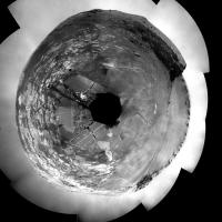
|
BTW, I haven't seen a polar projection posted here since quite a long time! A Mars bar goes to the person who points to the latest before this one.
Posted by: jamescanvin May 16 2008, 12:50 PM
http://www.unmannedspaceflight.com/index.php?s=&showtopic=4570&view=findpost&p=110655? (10th March) Not far from where we are now.
Posted by: fredk May 16 2008, 02:01 PM
I like the latest view!
http://qt.exploratorium.edu/mars/opportunity/forward_hazcam/2008-05-16/1F264186409EFF89AHP1157L0M1.JPG
Posted by: djellison May 16 2008, 02:37 PM
No motion of the unhappy-motor to do that though. I would have thought you would want to bring the arm up close to the vehicle so that any jolting has the smallest torque. If it's all stretched out, the jolting would be magnified quite a lot.
Doug
Posted by: dot.dk May 16 2008, 02:43 PM
Will we see the return of the elbow out stow on the deck?
They did some test driving with that configuration back then.
http://marsrover.nasa.gov/gallery/all/1/n/707/1N190952885EFF64KSP1938L0M1.JPG
Posted by: Tesheiner May 16 2008, 02:51 PM
http://qt.exploratorium.edu/mars/opportunity/forward_hazcam/2008-05-16/1F264186409EFF89AHP1157L0M1.JPG
I was never interested on those pictures before, because the forward view was kind of blocked by the IDD.
Now, I'm really happy to see this same picture after these weeks. Hope to be "on the road" soon.
Posted by: Tesheiner May 16 2008, 03:02 PM
Think so. Enjoy it!

Posted by: fredk May 16 2008, 06:05 PM
I'd be surprized too if they actually started driving with the arm in the current position. I imagine they are just doing tests with the arm now, and it will probably be some time still before we start moving again.
Posted by: djellison May 16 2008, 07:53 PM
Recent imaging looks to me like they've decided to use the left hand side of the Pancam CCD to avoid the worst of the dust on the lens, to get a really good sharp observation of the exit route.
Doug
Posted by: centsworth_II May 16 2008, 07:58 PM
Does this mean the quest to get a better look at the cape is over?
Posted by: Doc May 17 2008, 12:07 PM
It looks like it, i mean if u look at the situation right now it is reasonable to think that driving away from the Cape might be a good idea. Besides, apart from spectacular imagery potential, i am begining to think this quest for te Cape is as foolish as a guy trying to fly (apologies for those who were looking forward to seeing the Cape
)
Posted by: djellison May 17 2008, 01:03 PM
There's no reason why it is any less or more difficult to get closer to the cape. It's looking very unlikely we could put the IDD up against it, and the driving would be hard, but from what we have infront of us in terms of imagery - I don't think we can say they're not going to go, yet.
I would have thought the reason behind the 'exit site' imagery is because they had time on their hands waiting for IDD diagnosis, and given that if they go up to the cape or not, that's the way they're going out, it makes sense to get great quality imagery of that site now.
Doug
Posted by: Aussie May 18 2008, 05:13 AM
Otto Lilienthal must be rolling in his grave. I am sure that there is a lot of risk assessment going on, but I hope they go for it.
Posted by: mike May 18 2008, 06:11 AM
Why not go for the cape, who knows what's over there? You don't know until you try.
Posted by: centsworth_II May 18 2008, 03:05 PM
They've already tried once and gotten stuck. The question is,
do they understand what happened and do they think there is
a way to avoid the same problem on a second try.
Posted by: jamescanvin May 19 2008, 08:37 PM
Which is good news for us, although it does mean I have a lot more images to sort out!

|
Posted by: mhoward May 20 2008, 04:45 PM
I was pleased to see that the new subframe pan works pretty well in MMB. I hope they keep doing it this way; would make things a bit easier for almost everyone (one would think).
Posted by: dot.dk May 20 2008, 06:45 PM
A new update on the arm:
http://marsrover.nasa.gov/mission/status.html#opportunity
"Injured Shoulder Joint Back in the Game"
A very nice summary of what the story has been on that shoulder joint since SOL 2.
And it will most likely never be stowed again.
I never understood the reason to stow the arm on every little tiny drive.. Tiny drives that I can't imagine would do anything bad to the arm. Instead every drive they weared the joint motor during a stow+unstow. Longer drives over rough terrarin I would understand, but not tiny drives or drives over completely flat ground like around Victoria.
Posted by: jamescanvin May 20 2008, 07:01 PM
If you remember, they did experiment with doing small drives back in the 600's when the motor winding broke. The folks in the know, deduced that it could be a problem leaving it deployed and it was worth the risk to stow it. I believe that the thinking was that the motor was likely to fail due to day/night thermal cycling and not through extended use so it probably would have had this problem now regardless, and could have had a bigger problem earlier caused by shaking the deployed arm if the other option had been taken.
Posted by: climber May 20 2008, 08:04 PM
I'm astonished to learn again how good JPL engeneer are. The report say 3 times "This strategy worked for Opportunity until Sol XXXX".
I hope it'll work again until Sol xxxxx
Posted by: Tesheiner May 21 2008, 08:15 AM
This same status update has an answer to my, obviously incorrect, comment about "warmest time of the day" on a http://www.unmannedspaceflight.com/index.php?s=&showtopic=5054&view=findpost&p=113634.
They found that the resistance was lowest (essentially normal) when the joint was at its warmest -- in the morning, following deep sleep, after the heater had been on for several hours, and just before the T-stat opened. They decided to try to unstow the arm one more time under these conditions.
I have now the impression that these rovers will stop working only after completely blind and all motors have failed.
Posted by: BrianL May 26 2008, 12:32 AM
Awfully quiet in here. Where is everybody?
Brian
Posted by: mike May 26 2008, 01:27 AM
Trees on one side, fossils on the other.. they're both good
Posted by: fredk May 26 2008, 03:17 PM
Some news about Oppy buried in the flurry of Phoenix stuff at http://www.planetary.org/blog/article/00001446/
Posted by: Tesheiner May 30 2008, 02:33 PM
While all the attention is focused near the martian north pole, Opportunity is still testing the IDD.
Disclaimer: This is my first attempt to make a movie from still images.
Posted by: djellison May 30 2008, 02:58 PM
Wait...we have rovers now?
Posted by: dot.dk May 30 2008, 03:39 PM
What kind of testing are they doing right now? Moving the healthy joints in small increments. I'm curios what they learn by doing that
Posted by: jamescanvin May 30 2008, 05:00 PM
That has puzzled me too. I can only think that they are calibrating the joints so they can check for any problems more easily after driving with the arm unstowed.
Posted by: CosmicRocker May 31 2008, 06:22 AM
Posted by: ilbasso May 31 2008, 03:05 PM
They're called rovers...but neither one of them has moved much in the past couple of months!
Posted by: dot.dk May 31 2008, 03:40 PM
Something coming up tosol for Oppy maybe?
From the tracking page:
01547 p0161.01 0 0 0 0 0 0 navcam_1x1_az_108_1_bpp
01547 p0755.03 0 0 0 0 0 0 navcam_5x1_az_270_3_bpp
01547 p1214.05 0 0 0 0 0 0 front_haz_ultimate_4bpp_pri15
01547 p1242.02 0 0 0 0 0 0 FrRightHaz_wheel_sub_4_bpp_pri_19
01547 p1242.02 0 0 0 0 0 0 FrRightHaz_wheel_sub_4_bpp_pri_19
01547 p1242.02 0 0 0 0 0 0 FrRightHaz_wheel_sub_4_bpp_pri_19
01547 p1242.02 0 0 0 0 0 0 FrRightHaz_wheel_sub_4_bpp_pri_19
01547 p1242.02 0 0 0 0 0 0 FrRightHaz_wheel_sub_4_bpp_pri_19
01547 p1314.00 0 0 0 0 0 0 rear_haz_ultimate_4bpp_pri15
01547 p1342.01 0 0 0 0 0 0 RearLeftHaz_Wheelie_sub_4bpp_pri19
01547 p1342.01 0 0 0 0 0 0 RearLeftHaz_Wheelie_sub_4bpp_pri19
01547 p1342.01 0 0 0 0 0 0 RearLeftHaz_Wheelie_sub_4bpp_pri19
01547 p1342.01 0 0 0 0 0 0 RearLeftHaz_Wheelie_sub_4bpp_pri19
01547 p1342.01 0 0 0 0 0 0 RearLeftHaz_Wheelie_sub_4bpp_pri19
01547 p1990.07 0 0 0 0 0 0 navcam_1x1_Mast_El_neg60_4_bpp_crit
01547 p1990.07 0 0 0 0 0 0 navcam_1x1_Mast_El_neg60_4_bpp_crit
01547 p2124.03 0 0 0 0 0 0 pancam_cal_targ_L456
01547 p2600.12 0 0 0 0 0 0 pancam_tau
01547 p2600.12 0 0 0 0 0 0 pancam_tau
01547 p2601.03 0 0 0 0 0 0 pancam_tau_L78R48
01547 p2626.03 0 0 0 0 0 0 pancam_sky_radiance_thumbs_L457R247
01547 p2629.04 0 0 0 0 0 0 pancam_horizon_survey_L456
Posted by: Sunspot May 31 2008, 09:43 PM
..don't forget Opportunity.
Back on solid ground:
REAR: http://qt.exploratorium.edu/mars/opportunity/rear_hazcam/2008-05-31/1R265519687EFF89ATP1314R0M1.JPG
FORWARD: http://qt.exploratorium.edu/mars/opportunity/forward_hazcam/2008-05-31/1F265519740EFF89ATP1214L0M1.JPG
Posted by: djellison May 31 2008, 11:16 PM
GREAT stuff - now...onward to Cape Verde!
Doug
Posted by: dot.dk May 31 2008, 11:22 PM
The arm didn't move a single millimeter by the looks of it
And they finally got all wheels on the ground again
Posted by: Tesheiner Jun 2 2008, 10:58 AM
Good to see her out of the trap.
Last drive was executed in many steps, like the previous drive attempts. I calculated the slip factor on each of these steps and we can see a sudden decrease at the end of the drive: 93%, 95%, 95%, 85%, 51%.
Posted by: climber Jun 2 2008, 11:19 AM
I remember when Oppy get free of Purgatory. In the animation we could see the weels getting more and more efficient.
BTW, I guess Oppy has still the depth record in Mars diging. Not for long I guess, not for long.
Posted by: Pertinax Jun 2 2008, 12:53 PM
Please pardon the question: On Oppy's most recent fwd HazCam image, what is the circular brush for on the arm near the upper left of the image? I have not been able to remember it nor have I found any descriptive refrence to it in the little bit of searching I have done thus far this morning.
(And ditto the HURRAY for again being out of the 'trenches' )
-- Pertinax
Posted by: jamescanvin Jun 2 2008, 01:07 PM
That's been asked a number of times before around here.
It's to clean the RAT, in particular the magnets on the RAT I believe.
I can't ever remember it being used however.
Posted by: Pertinax Jun 2 2008, 01:18 PM
Thank you James.
I was sure it had been asked, and likely well more than once! Much to my frustration though I couldn't remember the answer! Arrgh.
Anyway, thank you again.
-- Pertinax
Posted by: BrianL Jun 2 2008, 04:16 PM
I don't know. I don't see Phoenix digging anything like this. Especially if ice is just a short distance down.
http://marsrovers.jpl.nasa.gov/gallery/all/1/r/484/1R171155999EFF55TIP1314R0M1.HTML
Brian
Posted by: Ant103 Jun 2 2008, 06:52 PM
Good to see Oppy finaly released of this sandy crap .
Here is a view front of the rover showing disturbed soil :
http://www.astrosurf.com/merimages/Opportunity/Panoramas/FinEnlisement-02-Sol1547.jpg
Have you seen the boulder ejected by one of the wheel?
Before : http://qt.exploratorium.edu/mars/opportunity/navcam/2008-05-31/1N265517626EFF89AHP1990L0M1.JPG
After : http://qt.exploratorium.edu/mars/opportunity/navcam/2008-05-31/1N265519524EFF89ATP1990L0M1.JPG
Maybe tilt of the ground have contributed to the rolling of this boulder (I want to say the "rolling stone" )
And a panorama at the other side :
http://www.astrosurf.com/merimages/Opportunity/Panoramas/FinEnlisement-Sol1547.jpg
Posted by: climber Jun 2 2008, 08:52 PM
Nice pano, Ant. I don't know why but , it looks different from the one before. May be because I'm more seen too much Northern plain panos
Posted by: Tesheiner Jun 4 2008, 08:51 AM
Well, the fight with the sand trap hasn't finished.
Here you have animated GIFs from the forward and rear hazcams and we can see that the rear-right wheel (left on the image) started to move up again. Slip factor on the two steps of the last drive (sol 1550) was 63% and then 91%.

|

|
Posted by: BrianL Jun 4 2008, 01:49 PM
Oppy, the message is clear. Victoria no longer wants you. She's clearly tired of you constantly staring at her cliffs and has said, nope, these are not for you. Sadly, it's time to move on. There are plenty of craters out there who I'm sure will be more receptive to your advances.
Brian
Posted by: charborob Jun 4 2008, 03:13 PM
I'm with you. Let's get out of here before Oppy gets stuck for good.
Posted by: djellison Jun 4 2008, 03:25 PM
One small quagmire does not render all of duck-bay unnavigable. Saying that Cape Verde is an impossible target is unjustified and probably quite wrong. Neither of you were in UMSF during the thrash to Burns Cliff. It took a long time, it meant getting stuck quite a lot - but it was worth it - it was worth every single sol it took to get there ( and it took a lot )
Doug
Posted by: akuo Jun 4 2008, 03:37 PM
I agree with Doug, Cape Verde is too good to miss now. If anything, the fact that the arm is out front has made it a more justified target now. In this position the arm can reach higher walls, if that is deemed possible. Also the drive to Cape Verde is the shortest distance to a real target, a lot of driving might damage the arm motors or joints if they start searching for science targets.
Posted by: climber Jun 4 2008, 04:38 PM
Plus, SS said they're going there
Posted by: fredk Jun 4 2008, 07:21 PM
Remember that the sun has been sinking lower in the north while we've been stationary here, so presumably it's gotten harder to approach close to Verde. Of course there's good reason to just get closer and image with pancam.
I've also been wondering about the trap that caught them here. It was not apparent before driving into it. How can they deal with this? Perhaps by following the outcrop north before dropping east closer to the cliff. They could certainly drive to Verde without trouble - the problem will be driving back up!
If these drivers are go for approach, so am I.
Posted by: fredk Jun 8 2008, 02:55 AM
Another drive attempt on sol 1552 - not much progress made; we seem to be mostly just rotating about our left side:
http://qt.exploratorium.edu/mars/opportunity/rear_hazcam/2008-06-07/1R265963490EFF89BAP1314R0M1.JPG
Posted by: Sunspot Jun 8 2008, 08:23 AM
http://qt.exploratorium.edu/mars/opportunity/forward_hazcam/2008-06-07/1F265963542EFF89BAP1214R0M1.JPG
Strange, the front wheels don't appear to be embedded in the soil. Perhaps the middle wheels are now stuck in something.
Posted by: Sunspot Jun 9 2008, 09:10 AM
http://qt.exploratorium.edu/mars/opportunity/forward_hazcam/2008-06-08/1F265962877ESF89B6P1242L0M1.JPG
Lots of subframe images from the hazcams.....
I don't like seeing subframes from the hazcams, they always make me nervous.
Posted by: peter59 Jun 11 2008, 06:23 AM
Oppy is free, I hope.
http://qt.exploratorium.edu/mars/opportunity/forward_hazcam/2008-06-10/1F266409751EFF89BKP1214R0M1.JPG
http://qt.exploratorium.edu/mars/opportunity/rear_hazcam/2008-06-10/1R266409699EFF89BKP1314R0M1.JPG
Posted by: Aussie Jun 11 2008, 07:14 AM
Now that is an unusual...thingy. (pointed out by 'Mann' on the yellow forum).
From the shadow it appears tubular with apparent structural rings? No bounce marks so not a rover part (thank goodness). Optical illusion? Any ideas? If nothing springs immediately to mind then a detour to have a quick look would be an attractive possibility. Hope Hoaxland doesn't notice it.
http://qt.exploratorium.edu/mars/opportunity/pancam/2008-06-09/1P264810378ESF89AHP2261L7M1.JPG
Posted by: climber Jun 11 2008, 08:01 AM
Doesn't look like an optical illusion. Seams to be sitting there instead of burried.
Can someone pointed out its location?
Posted by: Tesheiner Jun 11 2008, 08:11 AM
Almost, I would say. Last drive was executed in five steps and slippage was detected in all of them. But while the slip factor was in the 90% range on previous extraction attempts, yestersol it was: 79%, 84%, 76%, 64%, and 47%.
I wasn't doing these calculations before she got stuck here so I don't know if that 50% slip factor can be considered as "nominal" or not. But in any case it shows the trend observed on Purgatory (and similar).
MMB would be perfect, but I don't have it on this computer.
Posted by: Aussie Jun 11 2008, 08:27 AM
Can someone pointed out its location?
Hortonheardawho did a great job locating it in context.
http://www.flickr.com/photos/hortonheardawho/2567159743/
He also did a 3-D that really makes it an interesting item
http://www.flickr.com/photos/hortonheardawho/2567997844/in/photostream/
Posted by: Tesheiner Jun 11 2008, 08:28 AM
Ok. Here's a post of mine with a 360º navcam mosaic taken from almost the same position: http://www.unmannedspaceflight.com/index.php?s=&showtopic=5054&view=findpost&p=113712
The "little thing" can be seen on the soil on the general direction of Cabo Frio.
And here's the original image: http://marsrovers.jpl.nasa.gov/gallery/all/1/n/1508/1N262055670EFF89ABP1928L0M1.JPG.
It's near the bottom right corner.
Posted by: climber Jun 11 2008, 08:47 AM
Distance to Oppy ?
Posted by: Tesheiner Jun 11 2008, 09:05 AM
About 4 meters (based on the route map).
Here's another navcam picture (sol 1418) looking to the same area but from the opposite side but I can't distinguish "it" on the picture. A pancam would be nice however I can't find any.
http://marsrovers.jpl.nasa.gov/gallery/all/1/n/1418/1N254070138EFF8884P1785L0M3.JPG
Posted by: Tman Jun 11 2008, 10:08 AM
It's odd that nothing is visible in the navcam from sol 1418. The pebbles close-by can you pinpoint.
If it is a part from the rover, it may be such lightweight that it left no visible track.
Posted by: ngunn Jun 11 2008, 11:23 AM
'Obviously' a screw cap of some sort. Only one question: is it from the sun cream or the midge repellant?
Posted by: fredk Jun 11 2008, 04:14 PM
I measure 3.7 metres distance. That means it's about 1.5 cm in diameter.
It appears to be a rover part. As Tesheiner pointed out, it's not visible on sol 1418. Here are two navcam shots from slightly closer, on sols 1450 and 1462. In both it's quite clear that there's nothing at that position. But on sol 1486 there is something there. According to Tesheiner's map, we drove just upslope of that position on sol 1484, which is consistent with when it appears in the imagery.

|
Posted by: climber Jun 11 2008, 04:21 PM
What's the little "thing" at 8 hours visible on sol 1450 and 1462 and no longer visible on 1486 ?
Is the "thing" moving ?
Posted by: algorimancer Jun 11 2008, 04:48 PM
http://www.flickr.com/photos/hortonheardawho/2567997844/in/photostream/
Looks like a spring or a portion of a spring. Color would clinch it, but the coil direction seems to be clockwise with elevation, and the end of the wire seems to be at about 7 or 8 o-clock.
Posted by: fredk Jun 11 2008, 06:11 PM
I agree it looks like a spring. Here's a slightly improved image, the average of the two R1 frames we have, and enlarged 100%:
|
Any ideas what part of the rover this could come from?
Posted by: akuo Jun 11 2008, 08:43 PM
Hmm, maybe it's a part of wire covering that has dropped off. Some wires were cut by explosive cutters after the landing. It looks like it might be a part of a wire maybe from the back of the rover, for example visible in the rear hazcam:
http://qt.exploratorium.edu/mars/opportunity/rear_hazcam/2008-06-10/1R266409699EFF89BKP1314R0M1.JPG
Posted by: Aussie Jun 12 2008, 07:36 AM
You have to admire Hortonheardawho's eye for detail although a control comparison (another rock or berry in the frame) supporting Horton's comment that the brightness is comparable to the surrounds would indicate if the close match is significant. But the object at 11 o'clock does seem to fit the coil diameter. If there is a connection between these two then the wire proposal seems less likely.
http://www.flickr.com/photos/hortonheardawho/2571699228/
Say, what is the penalty for littering on Mars?
Posted by: Tesheiner Jun 12 2008, 08:41 AM
I would really like to see a pancam taken during this timeframe looking on that same area, if there is any.
Back to the sand trap topic, I was pleased to see that the planned sequences for sol 1559 contains a "normal pattern" of drive imaging ("penultimate" and "ultimate" hazcam pics). Opportunity is ready to leave this area.
Posted by: climber Jun 12 2008, 10:35 AM
Driving in the "object" direction?
Wondering if they're aware of it
Posted by: fredk Jun 12 2008, 03:13 PM
Me too. I couldn't find any pancam imagery from closeby. The imagery from the top of Verde is too far away to show the object if it was there. Frustratingly, we were very close to the spot on sol 1484 and http://marsrovers.jpl.nasa.gov/gallery/all/1/n/1484/1N259934767EFF8922P1927R0M1.JPG just misses it - the object is just below the bottom of the frame. I'm skeptical of Horton's second object - there are other similar cobbles around. I can't imagine that they haven't noticed it, climber - it's so obvious in the pancam imagery.
As far as the new drive, we have from http://marsrovers.jpl.nasa.gov/mission/status_opportunityAll.html#sol1545
Posted by: Tesheiner Jun 12 2008, 03:50 PM
I tried using the search options at the pancam site (something like "all pancams from sol X to Y and azimuth between A and B") and no luck.
Actually I got a "drive direction" image from that same sol 1484, but it has a pointing similar to the navcam you linked. It misses the area by a few degrees.
Let's see if they survey this area again on the way back from Cape Verde some months in the future...
> The staging area is about 15 meters (49 feet) away
If I did my math correctly, that's almost at the wall!
Posted by: BrianL Jun 12 2008, 04:33 PM
If they are talking about driving directly toward the wall, not angling up or down.
Brian
Posted by: jamescanvin Jun 13 2008, 03:52 PM
I think after The Quackmire and arm trouble, now would be a good time to start a new thread for the real approach:
http://www.unmannedspaceflight.com/index.php?showtopic=5242
Posted by: fredk Jun 14 2008, 02:53 PM
A 3D view of the glorious mess we made, pulling out of the Quackmire on sol 1559:

|
Powered by Invision Power Board (http://www.invisionboard.com)
© Invision Power Services (http://www.invisionpower.com)