Printable Version of Topic
Click here to view this topic in its original format
Unmanned Spaceflight.com _ Opportunity _ Winter campaign at Cook Haven
Posted by: mhoward Dec 13 2013, 04:31 AM
She's there! Opportunity drove down to the "Cook Haven" bright outcrops on Sol 3512.
Even better, news via Twitter that currents on the front right wheel are back to normal. Phew.
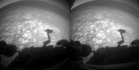
Posted by: jvandriel Dec 13 2013, 10:01 AM
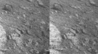
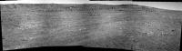
The view on Sol 3512 with the L0 Nav cam.
Jan van Driel

|
Posted by: fredk Dec 13 2013, 11:55 PM
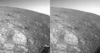
It's been a while since we've seen DD/gusts at Endeavour - here's a new example from sol 3514:
http://qt.exploratorium.edu/mars/opportunity/navcam/2013-12-13/1N440142386EFFCADPP1825R0M1.JPG?sol++++
Compare with this frame if you're unconvinced:
http://qt.exploratorium.edu/mars/opportunity/navcam/2013-12-06/1N439535492EFFCACMP1797R0M1.JPG?sol++++
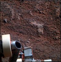
Posted by: mhoward Dec 14 2013, 12:53 AM
Ooh, nice catch. I'm going to claim I missed that because I was looking at the ground.
Here's "Cape Douglas" on sol 3512, at Opportunity's current location. I'd guess that Cape Douglas might actually refer to the larger rocky area she's next to, but hard to say.
|
Posted by: Phil Stooke Dec 15 2013, 01:07 AM
Wow, now there's a rover on Mars as well. What a world we live in!
Phil
Posted by: Pando Dec 15 2013, 03:51 AM
<checking calendar>
Uh, Phil, I thought rovers have been on Mars for a while... 
Posted by: Phil Stooke Dec 15 2013, 04:23 AM
Sorry - all my attention has been diverted to the Moon for a few days!
Phil
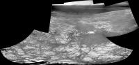
Posted by: jvandriel Dec 16 2013, 07:50 PM
The complete Navcam L0 view on Sol 3512-3514.
Jan van Driel
|
|
Posted by: dilo Dec 16 2013, 08:01 PM

Jan, did you noticed the wide dust devil on the left? I do not recall any dust devil seen by Opportunity before, but probably my memory is failing...

Posted by: centsworth_II Dec 16 2013, 08:09 PM
Check http://www.unmannedspaceflight.com/index.php?s=&showtopic=7708&view=findpost&p=205437
(Same dd image, I presume.)
Posted by: dilo Dec 16 2013, 08:28 PM
(Same dd image, I presume.)
Oops. I missed it! (and yes, my memory is definitely failing!)
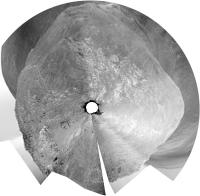
Posted by: Phil Stooke Dec 17 2013, 03:42 PM
Jan's panorama from just above in polar format. We are at the northern tip of a little outcrop that shows up clearly on the latest JPL route map.
Phil
|
Posted by: jvandriel Dec 19 2013, 09:30 AM
The Dust Devil on Sol 3514.
( 1 image Sol 3514 and the other one Sol 3520 )
Jan van Driel
|
Posted by: HughFromAlice Dec 28 2013, 08:31 AM
Quick stitch of Sol 3527 Pan Cams with slight adjustments of contrast etc.
If I wasn't going out tonight I would do more on this interesting set of jpegs.
|
|
And thanks for the comments on the YouTube vid. Pitched at a different audience
 (although I went for as much accuracy as possible). But I hope they like it too. A great adventure.
Posted by: jvandriel Dec 30 2013, 08:14 PM
The L257 Pancam view on Sol 3527.
Jan van Driel
|
|
Posted by: fredk Dec 30 2013, 08:47 PM
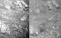
Here's a stretched difference of the (smoothed) 3514 and 3520 frames:

|
By matching features with an orbital view, I estimate the dd's distance as 2.9 km. That translates into a height of at least 230 metres. Since the dd extends to the top of the frame it is likely a fair bit taller than that. (You could estimate the full height from the length of the dark streak to its right, assuming that is its shadow.)
Posted by: fredk Jan 4 2014, 04:01 AM
Oppy's up to http://marsrovers.jpl.nasa.gov/mission/status_opportunityAll.html#sol3520 now. Recently she was 100 Whr below this level, and 371 is pretty high for this time of year. I wouldn't be surprized if levels like this mean more driving flexibility.
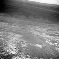
Posted by: Phil Stooke Jan 7 2014, 03:28 PM
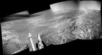
The big panorama being created now includes the best view yet of Cape York from this area. Here is a composite of two frames:
|
|
and a 3x stretch to help interpret it. The distant horizon ridge would run up to the Santa Maria area.
|
|
Phil
Posted by: fredk Jan 7 2014, 04:41 PM
Thanks for those, Phil. I can't wait to see this anniversary sequence in colour...
We haven't been to the distant ridge behind CY, but I see what you mean by it running to Santa Maria.
But we were in the direction of this frame, where we can also now see a distant ridge:
http://qt.exploratorium.edu/mars/opportunity/pancam/2014-01-07/1P442363437EFFCADPP2395L2M1.JPG?sol3539
This frame (more accurately the left side of the frame) is looking roughly towards where we made our big turn east after heading south from Victoria. I mentioned recently that our first sighting of Solander was around sol 2269 - that's also at the turn to the east. So we may now be seeing our route across the plains (though that depends how far away that distant ridge is).
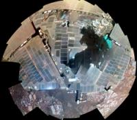
Posted by: udolein Jan 7 2014, 06:32 PM
My color version of Opportunity's Selfie of Sol 3538:
|
http://www.marspages.eu/media/archive4/mer_rover/opportunity/119newyear2014/Sol3538_Rover_Selbstportrait.jpg
Cheers, Udo
Posted by: Tesheiner Jan 8 2014, 06:41 PM
Here's http://www.planetary.org/explore/space-topics/space-missions/mer-updates/2013/12-mer-update-mission-nears-10-year-milestone.html, containing a lot of goodies as usual.
I just would like to highlight a few details about the winter campaign and future plans after this season.
"It's a beautiful stratigraphic section of crust that's exposed on the western side of Endeavour's rim," said Arvidson. "You can walk up and down through time and along time following the outcrop."
Posted by: ElkGroveDan Jan 8 2014, 07:45 PM
Thanks Phil. That perspective really highlights the how and why of the illusion we were all ensnared by a couple years ago where Cape York seemed to be a vertical-rising peak from the overhead HIRISE images.
Posted by: James Sorenson Jan 9 2014, 09:04 AM
I wasn't going to post this and just wait until the color images came down, but here ya go. More to come. 
http://www.flickr.com/photos/43581439@N08/11851064074/
Posted by: atomoid Jan 11 2014, 01:21 AM
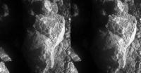
x-eyes of that amusing 'lil chunkster and stereo MI on http://www.midnightplanets.com/web/MERB/sol/03541.html reminds me of a rock I collected as a child in a volcanic steam vent in Hawaii.
|
|
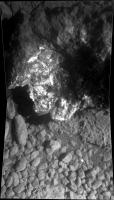
Posted by: mhoward Jan 11 2014, 02:11 AM
Wondering where 'Pinnacle Island' came from? So was I; well, I still am. But it looks like it appeared between Sols 3536 and 3540. So in other words, it probably appeared during the turn on Sol 3540. Neat, huh?
http://www.flickr.com/photos/marscat/11879656235/
http://www.flickr.com/photos/marscat/11879656235/ on Flickr
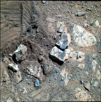
Posted by: djellison Jan 11 2014, 02:15 AM
Fascinating little rock - totally different to the bedrock beneath
|
Posted by: mhoward Jan 11 2014, 03:20 AM
It looks different from the bedrock underneath, but is it? Looking at the bottom edge in particular, I could almost image it's a piece of bedrock that was broken off and flipped over.
Edit: Actually, I figured out what it reminds me of, a bit. http://www.midnightplanets.com/web/MSL/image/00160/0160ML0866000000E1_DXXX.html. (Insert standard 'I'm not a geologist' disclaimer.)
Posted by: James Sorenson Jan 11 2014, 05:04 AM
Or "Tintina".
http://mars.nasa.gov/msl/multimedia/images/?ImageID=5145
But of coarse what we are seeing may or may not be similar materials.
Posted by: mhoward Jan 11 2014, 06:21 AM
I think 'Tintina' was just the name for part of 'Snake River' that got broken off.
Posted by: walfy Jan 11 2014, 08:41 AM
This rock must have popped out pretty far from under the rover's weight. A new record!
Posted by: SFJCody Jan 11 2014, 08:50 AM
Either that or it just fell out of the sky!


Then again, it does have kind of an iron-y, nickel-y look to it...
Posted by: climber Jan 11 2014, 12:36 PM
Any chance it was trapped in the weel and released during the turn?Doesn't tell more about the rock but just wondering about this possibility.
Posted by: mhoward Jan 11 2014, 01:33 PM
I am guessing - just guessing - that our little friend might have come from http://www.midnightplanets.com/web/MERB/image/03516/1P440321040EFFCADPP2380L2M1.html. (She drove over that spot on sol 3512.)
Color version:
|
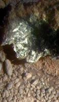
Posted by: jvandriel Jan 11 2014, 04:19 PM
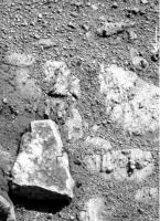
Here is the Mi cam panorama of that piece of rock from Sol 3541.
Jan van Driel
|
Posted by: nprev Jan 11 2014, 05:53 PM
That's almost more confusing. An encrustation of gypsum, perhaps?
Posted by: serpens Jan 12 2014, 03:09 AM
It really is a tiny piece and freshly separated (dust free). When Opportunity next moves it will be interesting to see the area obscured by the left front wheel where I would suspect it originated. A clast separated from the matrix rather than a fractured rock?
Posted by: dvandorn Jan 12 2014, 05:11 AM
The pattern of the light-toned mineralization looks like it followed a set of cracks in the rock. Suggests aqueous intrusion to me.
What also catches my eye in this picture are the extremely fine lineations on some of the darker rounded rubble at the bottom of the image. Many of the tiny pebbles have very fine-grained scallops along the edges, others have hair-like, perfectly parallel grooves, some display aligned pits along their rounded surfaces. I'm guessing these are the remains of extremely thin strata, I guess I would find it harder to believe they're carved by eon-long persistent sand particle saltation.
-the other Doug
Posted by: TheAnt Jan 13 2014, 02:16 PM
My immediate thought were that it might be a small piece of 'fool's gold' (FeS2 compound) but now nprev said gypsum I had a second look and indeed there's a small piece below that might have fallen off and it do look white.
Posted by: Zelenyikot Jan 14 2014, 08:46 PM
I'm not sure, but it seems like a coal 
|
Posted by: serpens Jan 14 2014, 09:53 PM
Probably gypsum although there are other possibilities. An APXS will narrow the field and we will no doubt get the good word in due course. Regardless the deposition implies a fracture which would explain this bit apparently breaking off so easily. There are a couple of displaced fragments of rock evident in mhowards image at post #318, located at the edge of the rock around 205 degrees from Pinnacle Island (taking the top of the image as north) which would seem to define the trajectory.
Posted by: RoverDriver Jan 14 2014, 10:14 PM
I'm not a geologist, but is it possible that could it be that it is http://www.livelaughrowe.com/wp-content/uploads/2013/12/Chocolate-Cupcakes-with-Peanut-Butter-Glaze-2-from-willcookforsmiles.com-and-livelaughrowe.com_.jpg and Oppy dropped it?
Paolo
Posted by: nprev Jan 14 2014, 10:37 PM
Good one, Paolo!!! (Long time no see, welcome back!)
Posted by: marsophile Jan 16 2014, 08:49 PM
Since there is no apparent trail leading to its current position, the rock must have flown through the air a fair distance. It seems difficult to explain how this could be triggered by the rover movement. Have we seen this kind of rover-induced rock mobility before?
Posted by: Phil Stooke Jan 16 2014, 09:01 PM
It's on rock. It wouldn't leave a trail.
Phil
Posted by: serpens Jan 16 2014, 09:35 PM
Ref my post #333, there are a few displaced 'pebbles' that, on rock, would seem to represent a trail.
Posted by: walfy Jan 16 2014, 11:18 PM
Does that trail lead down-slope? I couldn't figure it out by a quick study of the images. If the rock is downhill from its origin, that would explain part of the distance it traveled maybe.
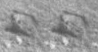
Posted by: atomoid Jan 17 2014, 12:27 AM
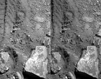
I never could find any trail of crumbs but the resting place is clearly downslope, apparently originating http://www.midnightplanets.com/web/MERB/image/03516/1P440321073EFFCADPP2380L5M1.html on the crushed area as http://www.unmannedspaceflight.com/index.php?s=&showtopic=7708&view=findpost&p=206315. just how far that is, vertically as well, has proven difficult to pin down..
|
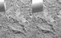
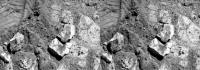
Posted by: mhoward Jan 17 2014, 12:38 AM
Interesting; I think there's more than a few pebbles disturbed. Here's a second attempt at a comparison, and you can see it looks like some bedrock has been disturbed (second circled area). (EDIT: Oops... actually not. On closer inspection, looks like it's just some dirt that got spread on the bedrock.)
Pinnacle Island is more or less northeast of the rover, so it's probably downslope.
http://www.flickr.com/photos/marscat/11988343703/
http://www.flickr.com/photos/marscat/11988343703/ on Flickr
Posted by: mhoward Jan 17 2014, 02:34 AM
Oops... I guess I have to retract the previous post. On closer inspection, it just looks like some dirt got spread on the bedrock. Oh well! Mystery definitely not solved.
|
|
Posted by: fredk Jan 17 2014, 02:38 AM
To me it just looks like the bedrock you're pointing to has had soil scattered onto it from the bottom direction on your image as PI skidded past.
Edit: you retracted before I finished posting!
I suppose that a loose piece of rock positioned just right as a wheel goes over it could be spat out at considerable speed, since the weight on the rock could be substantial. And that's even though the rover moves very slowly.
Posted by: mhoward Jan 17 2014, 02:43 AM
Yep... my bad.
Posted by: marsophile Jan 17 2014, 03:05 AM
That image is from Sol 3516. In Sol 3528 images, P.I. has not yet reached its destination, so that particular disturbed area could not be the origin of P.I. (EDIT: Unless it traveled very slowly.)
Posted by: Explorer1 Jan 17 2014, 03:28 AM
Steve Squyres on the Opportunity 10 year event:
2 theories about this rock's origin: either flicked by the wheels somehow, or a piece of new(!) crater ejecta: lots of sulfur, and apparently twice as much manganese as anything seen so far!
Posted by: serpens Jan 17 2014, 05:27 AM
High manganese deposited along a fracture implies hydrothermal deposition.
Posted by: dvandorn Jan 17 2014, 05:35 AM
Would manganese deposited hydrothermally be suspended in water in the form of a manganese salt? Or are there more complex chemical interactions which would keep manganese in suspension and then initiate its precipitation out of solution? And would this imply warm, or even hot water (i.e., would manganese come out of solution as the water cooled)?
-the other Doug
Posted by: Explorer1 Jan 17 2014, 05:46 AM
It's archived here:
http://www.ustream.tv/recorded/42795898
Skip to 25:20 for his comments on this rock/ejecta/thing. Squyres is skeptical of the ejecta theory, though Hirise would make certain...
Posted by: Pando Jan 17 2014, 07:27 AM
In mhoward's comparison image, looks like there is a second rock as well (circled red) that wasn't there earlier.
|
Posted by: mhoward Jan 17 2014, 04:41 PM
You're right, Pando! Makes one wonder what else is around. I tried a few crazy comparisons between Navcam and Pancam images but haven't spotted any other bits yet.
Posted by: TheAnt Jan 17 2014, 05:32 PM
This a time to play the 'Rolling stones' perhaps. =)
Posted by: Zelenyikot Jan 17 2014, 08:09 PM
The trace of "rolling stone"
|
Posted by: marsophile Jan 17 2014, 09:01 PM
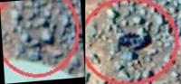
|
A closeup of Pando's comparison.
Posted by: serpens Jan 17 2014, 11:06 PM
More likely oxidation Doug so hot hydrothermal isn't necessary to the process. Interestingly enough Mn deposition has been connected to the authigenic formation of Fe-rich smectites such as nontronite. Fe-Mn oxyhydroxides in hydrothermal fluids can undergo early diagenesis with smectites being the Fe sink and with Mn precipitating, principally as nodules. So the high manganese reading dovetails with the smectites identified from orbit.
Posted by: atomoid Jan 17 2014, 11:29 PM
An excellent point. the only way out of the conundrum seems to be we simply haven't seen the actual disturbed area from which PI originated,
unless it just so happened to be picked up and transported inside the wheel to be released in a perfect ready-to-roll configuration in order to get to its resting place.. that all sounds more plausible the more I think about it. but did the sequence of wheel maneuvers support such a scenario?
otherwise I hope its indeed ejecta and perhaps the source a new priority destination.
whatcha know.. this discussion is getting some press:
http://rt.com/news/mars-rover-rock-appear-650/
http://www.news.com.au/technology/science/appearance-of-mystery-rock-alongside-mars-rover-opportunity-has-tongues-wagging/story-fnjwlcze-1226803349096
Posted by: marsophile Jan 18 2014, 07:03 AM
http://marsrovers.nasa.gov/gallery/all/1/p/3544/1P442802067ESFCAEOP2596R1M1.JPG
There is another disturbed area imaged on Sol 3544.
Posted by: RichforMars Jan 18 2014, 04:04 PM
I check Curiosity Rover's Raw images every day, I forgot about little Opportunity. Interesting how that rock got there.
I was searching for information on where it may be headed next? Once it has observed this location after the hibernation time. I can't find much on it.
Posted by: fredk Jan 18 2014, 04:41 PM
"Hibernation" is a strong word - Oppy should be able to keep working all winter, although probably not driving too much. As for what's next, check out Tesheiner's post http://www.unmannedspaceflight.com/index.php?s=&showtopic=7708&view=findpost&p=206215.
Edit - Sorry, that link doesn't quite take me to the right page - Tesheiner's post is #314, on the previous page. (Is there a technical problem with linking to posts? I got the link from the "Post #314" on the upper right of Tesheiner's post.)
Posted by: fredk Jan 18 2014, 05:00 PM
Gust of wind blowing across Endeavour on sol 3546, compared with a frame taken under very similar lighting on sol 3548:
|
|
Posted by: ngunn Jan 18 2014, 05:21 PM
I think this happens when posts get moved or deleted. The links can't cope with the renumbering that results.
Posted by: walfy Jan 19 2014, 10:05 AM
Regarding the origins of the mystery rock, it seems possible that the accumulated torque of two wheels going from pigeon-toed position to straight-ahead could have had a hand in popping out a rock., ... well, after attempting to put it in writing, I think a simple GIF might say it better, albeit crudely:
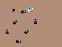
|
Of course, the rocks would have to be perfectly situated and sticking out just high enough for the wheels to get a toehold, with one rock not willing to budge, the other more willing if properly persuaded.
(I'm aware of the many inaccuracies in the above illustration, such as wheel layout, type of rock I picked, and sure there are many more. I don't have time to correct them, just trying to convey idea of two rover wheels doing some prying-apart action. My apologies if someone already floated this idea!)
Posted by: mhoward Jan 19 2014, 03:36 PM
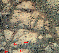
Here's something that Stu spotted that I think is quite interesting. It looks like a couple small rocks with long trails behind them. Stu created an animated GIF with lines next to the trail-like features; they're subtle. I looked up the images in MP for some context: the trails are not obviously downslope, they go more west-ish, although I suppose they could be a bit downslope locally, it's hard to tell. Stu gave me permission to post this to see what you think.

|

|
Posted by: djellison Jan 19 2014, 03:46 PM
Are you aware that the front right steering actuator has been broken for 8 years? It doesn't steer - it's locked with 8 degrees of toe in.
Posted by: fredk Jan 19 2014, 05:33 PM
Of course RF doesn't steer, but that still leaves three steering wheels. Walfy's idea actually sounds like the second good idea we've heard (after the obvious rock-popped-out-while-being-driven-over).
The basic problem is that Pinnacle Island moved a considerable distance, as the debris on its rover side indicates. The slopes here are fairly subtle, around 15 degrees. In Mars gravity, that seems to be too shallow for a rock shaped like PI to roll easily. So PI must have been given a kick somehow. Getting squeezed under a wheel, and now Walfy's idea are the only ideas that seem to work. (The wheel rotation speeds are so slow that I can't believe PI being trapped inside a wheel and then spat out. And the odds of a meteor strike nearby have to be incredibly small.)
Posted by: fredk Jan 19 2014, 05:40 PM
I think the human eye is excellent at finding features like that, but I don't think these are trails left by rolling rocks. We know what disturbed soil looks like on Mars - I'd expect much more obvious darker patches due to the soil underneath being exposed (if these were recent, at least).
Posted by: djellison Jan 19 2014, 06:17 PM
The turning of a steering actuator flicking a rock across the ground? Have you seen how slow the wheels steer? It's incredibly slow. Sorry - I don't buy it. Moreoever - how would a steering actuator throw a rock infront of the rover? Walfy's animation shows it being throw away from the rover....not right infront of it.
I don't know if it's ejecta...it does inherently seem unlikely - but it's not that far beyond the realm of possibility. The modern day cratering rate as derived from orbital discoveries is such that I believe it was characterized thus : Within the duration of one crewed surface mission of a martian year - statistically there would be a new impact crater formed within earshot. We've been here 5 martian years. It's far far from impossible that it could be a piece of ejecta. It could be a tiddlywink's like pinging of a rock from under a wheel. But a steering actuator didn't just flick a wheel several meters....I don't buy it.
Posted by: Juramike Jan 19 2014, 06:33 PM
http://spacecoalition.com/blog/new-info-mars-rock-mystery
"Candidate divot" hinted at in the interview. Which is good, indicating it's originally from close by and can be put in geological context.
Posted by: Explorer1 Jan 19 2014, 06:39 PM
If it is in fact from a crater, visiting something that fresh would be amazing for science return: seeing what else was excavated, maybe even the original meteorite itself if it was a small impact (say Heat Shield Rock sized)
Of course, even if Hirise/CTX spot something new we shouldn't get our hopes up to visit it right away. They'll probably have to wait for winter to end to actually be able to access it (and finish the science campaign right here at Solander).
Posted by: fredk Jan 19 2014, 08:10 PM
Exactly. As Walfy's animation shows, the idea is not that the slow movement of the wheel while steering acted like a golf club or putter to shoot the rock out. Of course that could not happen. The idea is that the rock was stuck in place, which would not be surprizing. As the steering wheels turn against the rock, the force builds until the rock's connection to the ground snaps. Suddenly it's free and you'd expect it to move out faster than the speed of the steering wheels. And there would have been two steering steps, at the start and end of the turn - is it clear that neither could've snapped the rock out in the right direction? Perhaps it ricocheted off another wheel?
About ejecta, we need actual numbers to say anything definite about how likely a nearby hit is. But this is what makes me extremely sceptical: We've seen several meteors within pancam-shot of Oppy, but no evidence of recent hits (last 10 years, say) of meteors or ejecta. So what are the odds that when we do see a fresh piece of ejecta, it hit within a couple of metres of Oppy? Surely it would've been far more likely to hit a few years ago, say, and then we drove up to it. It's the close link with Oppy and the timing that strongly suggests a connection with the bump on 3540.
Posted by: fredk Jan 19 2014, 08:43 PM
Probably what marsophile pointed out above:
http://marsrovers.nasa.gov/gallery/all/1/p/3544/1P442802067ESFCAEOP2596R1M1.JPG
That's on the left-rear side of the rover.
Posted by: nprev Jan 19 2014, 08:51 PM
Doug, you may know this: Is someone actually compiling MRO data to derive an impact probability for a given location on Mars within so-and-so many meters or km over a fixed timespan? If so, I'd guess that they're still acquiring data to firm up the model.
I agree with Fred in any case; odds are overwhelmingly in favor of this being an uprooted rock that was transported for a bit.
Posted by: ngunn Jan 19 2014, 09:39 PM
It's intriguing though that it has a 'very unusual composition'. Does that mean that all the rock at this spot is 'very unusual' or that this particular rock is atypical of its surroundings? In the latter case we are twice fortunate that an unlikely case of wheel tiddlywinks happened to turn up a very unusual rock.
Personally I think everything points to this special rock being spring-loaded. It was primed to leap in the air as soon as anybody touched it.
Posted by: serpens Jan 19 2014, 09:41 PM
That is the most logical explanation to date Fred and Walfy. As previously mentioned this rock looks like it separated along a fracture which would permit the build up of force until the (hydrothermally derived) material deposited within the fracture gave way, providing a reasonably significant kick off velocity. This scenario would I think provide the necessary accumulation of force and instantaneous release, whereas a loose rock, even in duricrust would provide much less resistance and a more gradual release. I am not sure that the actual turning of a wheel would accumulate the necessary force and I would assume that there would be some feedback based control to preclude the wheel turning against significant resistance? I would therefore tend to punt for the RF 'frozen' wheel being the prime suspect as during a turn, for some encounter orientations, it would push against an obstacle rather than over-ride it and the inertia of the rover in the turn would provide a significant force.
Posted by: djellison Jan 19 2014, 10:00 PM
Already done, put to paper, peer reviewed and published
http://www.sciencedirect.com/science/article/pii/S0019103513001693
Walfy's animation seemed to me to suggest it was just a steering actuator bashing something out the way - which I hope we all agree is just not going to happen.
The notion that rover motion (of any sort) could end up 'popping' a rock into motion is fine. This all falls under the tiddlywinks category, surely? It's really not a separate means of flinging material
Posted by: nprev Jan 19 2014, 10:02 PM
Huh. Didn't know they'd found so many thus far. Thanks!
Posted by: marsophile Jan 20 2014, 03:11 AM
A few possible scenarios:
1. One rock acting as a lever, one rock acting as a fulcrum, the rover weight on the lever.
2. Rover starts passing over a slab with a hollow underneath. When the rover is halfway the rock breaks under the weight of the rover. The part that is not under the rover gets flung into the air by the force of the so-called normal reaction to the weight of the rover. (This is similar to Fredk's suggestion except it is the weight of the rover rather than the forward momentum that snaps and throws the rock.)
3. Ngunn's suggestion about spring-loading. The rock may have been under stress to begin with and Oppy's turn was the "straw that broke the camel's back."
4. The soil under the hard crust may be under pressure in places, or perhaps sparks or heat from the pressure of the rover weight reacted with some volatile.
More interesting than the origin may be what the rock can tell us about the subsurface. Perhaps we should try to duplicate the event that produced the rock in other likely places.
Posted by: CosmicRocker Jan 20 2014, 06:32 AM
I'd have to say that walfy's suggestion sounds the most plausible to me. A rock propelled by stored-up energy from the rover's suspension/frame/wheels system during a turn just seems most likely to me; especially considering that we can see a similarly sized, disturbed area quite nearby, and aligned with the projected path of Oppy's wheel tracks.
Regarding the curious composition of P.I, we really don't know whether or not that is anamolous in this locality. Furthermore, we rarely, if ever, have seen Opportunity analyze the bottom side of a flipped-over piece of rock. Who knows which salts might have accumulated in that environment?
It's been a while since we've had a bonafide Martian mystery like this to unravel. Good work, everyone. This is fun.
Posted by: mhoward Jan 20 2014, 05:45 PM
Some post-brush Pancam images of Cape Elizabeth came down. The post-brush color of Cape Elizabeth looks a lot like the interior color of Pinnacle Island to me. Here's the L257:
|
Posted by: marsophile Jan 21 2014, 02:37 AM
I notice the dust factor has been steadily improving over the last several status reports.
The rover has been tilted during this period. I wonder if the simple fact of being tilted could affect the deposition/removal "budget" so that a small net deposition could be transformed to a small net removal. Presumably the deposition comes mostly from the vertical fall of dust so a tilted rover might present a smaller collection area. On the other hand, the wind might be primarily horizontal so a tilt might help there.
Posted by: atomoid Jan 21 2014, 07:51 PM
IMHO, I can't visualize a tiddlywink or leveraged snap-effect scenario really having enough rebound to push a rock more than a few cm, and though I might be completely wrong, this rock seems so crumbly its hard to see much stress building up.
While still somewhat far-fetched, though still seems most feasible to me (and I still don't know if the wheel configuration and maneuvers support it, because it requires the wheel to be upslope for the 'catch' and downslope for the 'release'), is the wheel abutting against the PI source and dislodging it so that it becomes deposited inside the interior of the wheel.
At this point when the wheel turns, since PI would lie flat as a sort of hemi-square wheel shape, it should, as the wheel turns slowly, usually become rotated to a near vertical orientation inside the wheel and so as the angle of lean transfers to the tip-over point, it could either be re-deposited back inside the wheel for another rotation, or if its on the edge of the wheel in the right configuration, can escape in that vertical orientation, and may accumulate some extra height if it hangs on long enough.
So then if the part of PI that then contacts the ground is not the square half, but is the roundish half, and the ground has enough slope to it (a 15 degree slope isn't quite trivial), PI may gain enough speed from that small drop to roll several revolutions until the square sections stall it to flop over into its current location.
Posted by: fredk Jan 21 2014, 08:39 PM
The main problem with propelling PI is converting the very slow rover and wheel movement into rapid PI movement, and what you're saying about the rock inside the wheel hitting the "tipping point" as the wheel rotates sounds like it would do that. Getting PI out of the wheel sounds trickier. The wheel being on a slope might help - with the right tilt, PI would move outwards as well as downwards once it started to slide inside the wheel. You could use basic physics to work out PI's maximum speed as it left the wheel. Friction would make it slower though.
It would help to know exactly where PI came from and how far that is from it's current location. We have a candidate "divot" - it shouldn't be too hard to estimate the distance from there to it's current location. Of course turning in place and driving can do multiple damage to the ground, so the visible divot may be unrelated to PI, and the real source may be underneath us and invisible, at least until we move again.
Posted by: marsophile Jan 21 2014, 11:25 PM
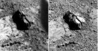
http://marsrovers.jpl.nasa.gov/gallery/all/1/r/3540/1R442458677EFFCAEOP1311L0M1.JPG
The "divot" and some of the area around it is visible in the rear hazcam from Sol 3540.
|
A closeup (but fisheye-distorted). Compare with
http://qt.exploratorium.edu/mars/opportunity/pancam/2014-01-20/1P443512347ESFCAEOP2599R1M1.JPG
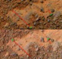
Posted by: MaxSt Jan 22 2014, 09:26 PM
Looking at this:
http://www.jpl.nasa.gov/spaceimages/details.php?id=PIA17761
I think a few small pebbles slightly below the rock moved too.
|

|
Posted by: marsophile Jan 23 2014, 04:20 AM
|
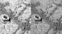
Before and after shots of the disturbance. It seems to have dislodged a large rock. Below and to the left of the moved rock, there may be a smaller disturbed area partly in shadow.
Posted by: Mr Valiant Jan 23 2014, 12:06 PM
Marsquake? Or should we see more substantial alteration to the enviroment? Wait for MRO check for impact theory, if none, then a bit of back tracking might reveal more moving rocks and pebbles.
Posted by: fredk Jan 23 2014, 04:36 PM
Hey marsophile, what image is that on the left side of your composite?
Posted by: RoverDriver Jan 23 2014, 04:53 PM
...
From my observations of the testbed when driving and turning on hard surfaces, the right rocker can store large amounts of energy in the deflection during a turn or a drive. When the energy gets released it is released in a very short amount of time and has quite a punch. So *I* would not be surprised if PI was kicked by the RF wheel using energy stored in the strut during a maneuver. See, not only the rock was moved, but also turned upside down, I think. I doubt we will ever know what really happened.
I also think that Oppy is just trying to steal some of the attention Curry is getting.
Paolo
Posted by: marsophile Jan 23 2014, 05:25 PM
http://marsrovers.jpl.nasa.gov/gallery/all/1/f/3514/1F440141643EFFCADPP1214L0M1.JPG
Front hazcam from Sol 3514.
By the way I had to manually massage the right image (rear hazcam Sol 3540 taken from further away) to get it to approaximately match the perspective. I stretched the Y-coord, rotated, and then squeezed the X.
Posted by: atomoid Jan 23 2014, 09:13 PM
I also think that Oppy is just trying to steal some of the attention Curry is getting.
Paolo
Very interesting and illuminating Paolo. I had visions of this monotonously slow crawl, its good to know Oppy has some 'spunk' in its legs!
In the dislodged rock from http://www.unmannedspaceflight.com/index.php?act=attach&type=post&id=31972' sequence a few posts above, the area 'kicked up' is so flat that it is surprising a rock could have been pulled up, as its definitely a rock and not a 'divot' as evident in the xeye below. That it was actually exhumed without any apparent prominent feature that the wheel could 'hook' onto to pull it up so the wheel must have had to dig in to something at just the right place to pull it up.
That said, it doesn't seem obvious as the source for PI, though there isn't enough detail to be sure, its could be a broke-off section of it..
|
Posted by: fredk Jan 23 2014, 09:22 PM
Yeah, thanks Paolo for that insight.
In today's teleconference, Squyres thought that the source of PI is currently out of view below the rover. They plan to move and image the area to try locate it.
Posted by: fredk Jan 24 2014, 01:04 AM
Speaking of moving, there was a tiny shift in position on 3555 (with new rhazcams). Compare these frames:
http://qt.exploratorium.edu/mars/opportunity/forward_hazcam/2014-01-20/1F443426738EFFCAEOP1110R0M1.JPG?sol3551
http://qt.exploratorium.edu/mars/opportunity/forward_hazcam/2014-01-23/1F443784271EFFCAEUP1214R0M1.JPG?sol3555
Posted by: marsophile Jan 24 2014, 07:07 AM
|
There seem to be some raised parts that might have provided leverage. [EDIT: It's like the old gag where someone steps on the teeth of a garden rake, and the pole jumps up and hits him in the face.]
Posted by: Tycho Jan 24 2014, 09:44 AM
My idea:
First the wheels of Opportunity had loosen the little rock out of the ground, increasing its wind attack surface.
Second step is the wind that came and blew it down the slope.
Do we have any knowledge about the weight of this piece?
And what about wind speed during the last sols?
Posted by: RoverDriver Jan 24 2014, 03:50 PM
If there was a wind so powerful to move and turn over this rock, the solar deck would as clean as new and we would definitely know about it.
Paolo
PS: Happy 10 to all of you.
Posted by: Tycho Jan 24 2014, 07:34 PM
Sorry, Paolo, but I can't imagine even a storm cleaning the solar cells.
I never had a clean car after I ran the German Autobahn.
Posted by: elakdawalla Jan 24 2014, 08:12 PM
Here's an interesting factoid I learned while doing book research: wind more readily lifts sand-sized particles than clay-sized particles, both on Earth and on Mars. It was a mystery until pretty recently how dust was getting lifted off the Martian ground into the atmosphere, when sand didn't seem to move much. Dust devils seen by MGS provided one answer, with their vacuuming effect -- that could lift dust, while straight-line winds couldn't. Then Spirit's MI provided another answer, showing that dust on rocks in Gusev had clumped into aggregates large enough for the wind to effectively pick up before the aggregates poofed apart into their component dust particles. So if you see a surface that's really coated by really fine dust, it's not obvious that even a strong wind will clear that dust off, yet another reason that the fact that cleaning events happen is such a pleasant surprise.
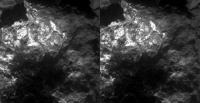
Posted by: marsophile Jan 24 2014, 08:55 PM
|
Parallel-eye, not cross-eye, for better depth perception.
Yesterday's rear hazcam gives a better view of the divot area. The moved rock seems to have broken into two pieces. The upper piece has a cavity.
Posted by: ngunn Jan 24 2014, 10:12 PM
Very interesting. It's obvious there's something amiss with the theory. On Mars the dust is clearly more mobile than the sand or else everything would be grey not red.
Posted by: Tycho Jan 25 2014, 02:09 AM
Once lifted in the atmosphere, clay-sized particles stay there for a very long time, mixed up by the wind again and again and spread all over the planet. The sand falls down immediately. Remember there is no rain to wash out the atmosphere.
Posted by: algorithm Jan 25 2014, 09:04 PM
Looking at post #86 from mhoward, I noticed a coloured patch on the ground above PI the same as it's 'interior'. Does anyone think there is a link? Maybe this is an impact site where the rock landed (launched by your favourite method) and then rebounded, performing a half sommersault, and then landing in it's present position.
Or am I as mad as a bag of badgers?
Posted by: mhoward Jan 25 2014, 09:22 PM
That's the brush mark.
Posted by: algorithm Jan 25 2014, 09:33 PM
You sure?
Strange shaped brush.
Was the inside of the rock brushed as well?
Posted by: fredk Jan 25 2014, 09:41 PM
The brush spins, so normally makes a disc-shaped mark. In this case it looks like the plane of the brush was tilted a bit compared to the ground, so only made contact on a portion of the disc (we can see the lower part of the disc).
I think it's pretty unlikely that they'd try to brush a small, loose rock like PI - I doubt the rock would sit still!
Posted by: algorithm Jan 25 2014, 09:44 PM
I mention brushing the rock because of the similarity in colour. The reason for my post in the first place.
Posted by: ngunn Jan 25 2014, 09:51 PM
Also, being freshly dug up it has no dust on it so it doesn't need brushing.
We have been told that the interior of the rock is chemically unusual but so far nothing about the bright teeth around the perimeter, or have I missed something?
Posted by: algorithm Jan 25 2014, 10:06 PM
Because the colour of the inside of the rock is so similar to the 'brush' mark would that indicate that it hasn't been carried that far, or would it put a limit on how far it could have been carried, or an indication of where it may or may not have come from?
And would the place that it came from now be the same colour as the brush mark?
Posted by: mhoward Jan 25 2014, 10:28 PM
Strange shaped brush.
Yes, pretty sure in this case: the mark wasn't there in earlier Pancam images before http://www.midnightplanets.com/web/MERB/image/03541/1F442544027ESFCAEOP1140L0M1.html. And it looks like a typical glancing brush mark.
Posted by: ngunn Jan 25 2014, 10:30 PM
I don't think it has been carried far, just kicked out by a wheel scrunching around in a turn or whatever. Should it match the place where it came from? Yes.
Posted by: mhoward Jan 25 2014, 10:36 PM
As for whether the corresponding hole in the ground (assuming it exists) exposes the same colors, I believe Steve Squyres said at the http://www.planetary.org/get-involved/events/roverparty/20140123-planetary-radio-live-rovers.html that's something they'd like to find out, and they will be moving the rover soon to try to take a look.
Posted by: fredk Jan 26 2014, 12:57 AM
http://www.sciencedirect.com/science/article/pii/S0019103513001693
Thanks for the reference. I finally had a look at it, and, judging from Fig 4b, the observed cumulative crater frequency is a bit over 2*10^-6 craters/km^2/year. That's for all craters larger than the smallest observed (roughly 1.5 m diameter). So in 10 years, the odds are about 2*10^-5 that a crater would form within one square km of Oppy.
Even if you follow the trend of the models, which predict higher rates than the observations, the odds are perhaps only 10 times larger (hard to be sure, since the model predictions aren't given for the smallest craters). I guess you should also add meteors small enough that they don't produce craters, but the trend of the cumulative curve (4b) is not promising.
Either way, Oppy would be very very very lucky to experience a meteor hit that close.
On the other hand, the odds are good that Oppy has been within very roughly a 130 km radius of a meteor strike in these 10 years...
Posted by: jvandriel Jan 26 2014, 10:16 PM
The Navcam L0 view on Sol 3555.
Jan van Driel
|
|
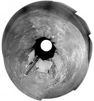
Posted by: Phil Stooke Jan 26 2014, 11:45 PM
This is a quick polar version of Jan's new panorama.
Phil
|
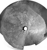
Posted by: Phil Stooke Jan 27 2014, 12:03 AM
And this, by tilting the projection plane and shrinking radially, puts the area in more of a map-like geometry.
Phil
|
Posted by: jamescanvin Jan 27 2014, 09:24 AM
The first of Phil's polar images gives a real sense of the slope Oppy is on. Staring at it in my half awake Monday morning state, I get a real feeling that I may fall off the top of the rover and roll down Solander Point.
Posted by: atomoid Jan 28 2014, 10:44 PM
xeye of the 'Disturbed Clast' from http://www.midnightplanets.com/web/MERB/sol/03550.html
|
I don't see much disturbed in 'Green Island' http://www.midnightplanets.com/web/MERB/sol/03552.html, maybe a scuff at left..
|
|
Posted by: fredk Feb 4 2014, 03:23 PM
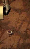
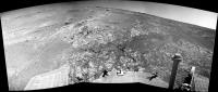
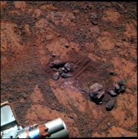
After a short bump downhill we finally have a view of what was under the rover:
http://qt.exploratorium.edu/mars/opportunity/navcam/2014-02-03/1N444761498EFFCAFCP1962R0M1.JPG?sol3566
Pinnacle Island is the small rock just above the left edge of the sundial. We can now see a messed-up area farther uphill that looks like a potential source for PI.
Posted by: jvandriel Feb 4 2014, 08:02 PM
Here is the panoramic view stitched together from L0 Navcam images
taken on Sol 3559-3560 and Sol 3564.
Jan van Driel
|
and Sol 3566
|
Posted by: ngunn Feb 4 2014, 09:36 PM
It's clear from examples like Pinnacle Island, the deliberate crushing of gypsum veins at Cape York, Spirit's serendipitous discovery of silica and other examples that rover wheels are valuable geological tools in their own right, so I have a question for the engineers (including armchair engineers). How might you modify wheel design to maximise this function? Add a thin outstanding flange somewhere in the otherwise wide flattish tread profile perhaps? Have occasional small cup-shaped scoops or spikes at intervals around the wheel perimeter? Extra cameras? Any ideas?
Posted by: walfy Feb 4 2014, 10:08 PM
I've always wondered if a rake has ever been considered, one that can be routinely dragged when roving over promising terrain, just enough to turn over some rocks and stir things up for a better idea of what the dust layers are hiding. Extra science could be had by taking advantage of the routine long drives, by dropping a rake at intervals just behind the rover, followed by a some pictures, and dragging would be well within the capabilities of the wheels. In case the device got stuck in the down position, some explosive bolts could get rid of it!
Posted by: MahFL Feb 5 2014, 01:36 PM
There are probably 50 engineering reasons why that is a bad idea, lol.
Posted by: Phil Stooke Feb 5 2014, 02:01 PM
The rake idea is pretty much what Spirit did when it was dragging a frozen wheel - digging a trench in the soil (making major discoveries as it did so, salty soils and silica) or moving small rocks. So basically that could be recreated at will by driving five wheels and not driving the sixth, without adding the complications and mass of a rake and the mechanisms needed to raise, lower and eject it.
Phil
Posted by: dvandorn Feb 5 2014, 02:49 PM
There are a number of different configurations you could use for a rake-like implement off of a rover, though. A large flap-like rake would serve to disinter buried rocks and pebbles, at the cost of possibly getting hung up and also of piling up large mounds of dirt. However, a dixie-cup-sized device, open at one end and with a mesh at the other, could be used to collect cobble-sized samples which are shallow-buried for a sample return mission.
For in-situ analysis, you would need to identify a need to disinter buried cobbles as part of your sampling methodology for this kind of device to become important. For example, if you come up with a theory that only buried rocks will display a given desired-to-observe chemistry, you might want to develop a way of disinterring such rocks for easy transport to your sensors.
I get the gut feeling that such a sampling methodology would be more useful for sample caching in preparation for a sample return mission than for in-situ analysis. But in either case, I'd think you would need a compelling reason for wanting access to shallow-buried rocks before getting into the complexities of designing such a raking mechanism.
-the other Doug
Posted by: Gerald Feb 5 2014, 02:59 PM
A wheel with a partially sandpaper-like surface may be usable for an on-the-fly rock abrasion.
Edit: E.g. round patches on a wheel; rock could be abraded by steering in-place to the left and right.
Posted by: djellison Feb 5 2014, 03:36 PM
We have the RAT ( on MER ) and DRT ( on MSL ) for that. Using a wheel for it would be a messy affair.
And with all the notions of a 'rake'....you have to consider what would you take off MSL or MER to make room for it in terms of mass, volume, power..and budget. Such notions are not free...and you have to consider the cost to the vehicle.
The wheels do a great job when required for simple trenching, crude abrasion....and at the same time are useful for getting around. Extra hardware really isn't justified.
Posted by: atomoid Feb 5 2014, 05:16 PM
I had always wondered what kinds of pressures could be exerted using the arm, for instance to move a rock, perhaps the RAT would be the most appropriate contact point, my thought is that it would seem possible of being useful, though clearly such purpose was not designed in and re-purposing the existing assembly to do so is evidently fraught with unacceptable risk. I assume some thought went into this general concept for MSL, if not MER, though apparently not chosen as a route worth pursuing..
Posted by: djellison Feb 5 2014, 05:32 PM
You enter a world of many many unknowns when you start trying to shove things around. Will it move at the toque the arm can handle - will something roll back and put torque on the system etc etc.
http://www-robotics.jpl.nasa.gov/publications/Eric_Baumgartner/IPS_IEEE_Aerospace_2005_final.pdf has some good IDD spec - including typical preload forces on the RAT of around 30N. The IDD is a very fragile thing. The Phoenix arm was a brute of a thing that could really bring some torque to the game, MSL's is about inbetween I believe.
Posted by: atomoid Feb 5 2014, 10:10 PM
Thanks for finding that. very illuminating of the ingenuity involved in solving the myriad dilemmas and giving us 5mm positioning accuracy.
a favorite highlight (p4):
"The mass allocation for the IDD of 4.4 kg, including launch restraints and cabling, was also an extreme design driver. The cabling mass alone, mostly to support instruments, was almost 1 kg. The arm had to support a turret of instruments with a mass of 2 kg, provide preload for the RAT, and be capable of achieving the absolute and repeatable positioning requirements described in Section 2.
The mass allocated and load magnifications possible with the 5 DOF robot arm did not allow the structure and joints to be designed in such a way that the arm could not damage itself in all possible operational cases. Instead, an approach which integrated flight software fault protection, operational constraints, and mechanical capability was developed that reduced the risk of damaging the IDD during normal operations. Joint flexibility became particularly important since arm configurations that cause dangerous load magnifications also allow for significant travel past the point of instrument contact before the loads reach their critical stage. A redundant method of terminating IDD motion based on contact sensor feedback and tight limits on over travel past the expected contact point keep the arm in the safe load zone. While the torque used to get the joints started is capable of creating unsafe loads, software quickly ramps the current limit down after movement starts before more movement occurs than arm flexibility can accommodate. Software also limits the torque of the motors when the arm is in configurations that can magnify loads."
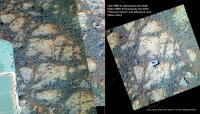
Posted by: atomoid Feb 5 2014, 10:24 PM
http://qt.exploratorium.edu/mars/opportunity/navcam/2014-02-03/1N444761498EFFCAFCP1962R0M1.JPG?sol3566
Pinnacle Island is the small rock just above the left edge of the sundial. We can now see a messed-up area farther uphill that looks like a potential source for PI.

|
Posted by: marsophile Feb 6 2014, 03:03 AM

|
Thanks! That explains how the rover might kick a rock over some distance. But could the rover motion also produce a fresh crater like the one (above image) at Stewart Island?
Posted by: serpens Feb 6 2014, 07:05 AM
That doesn't seem to fit any definition of crater. Seen in context in atomoid's much appreciated x-eye it is pretty clear that the wheels gave that rock a fair working over, pushing the regolith into a mini berm.
Posted by: marsophile Feb 6 2014, 06:17 PM
Are you saying the wheel rotated the rock, causing it to carve out a bowl-shaped depression? Yes, that would explain it.
Posted by: djellison Feb 6 2014, 06:48 PM
I don't think anyone was expecting to see a 'crater' ( this location was, after all, directly under the rover when Pinnacle Island showed up so you would have needed a neat hole straight thru the rover to cause it ) - the 'crater' hypothesis was such that somewhere nearby ( 10's of meters, hundreds of meters, km's away perhaps ) a crater was formed and PI was a piece of ejecta from that.
However - I think we have a smoking gun in the form of wheel/rock/digup/tiddlywink interaction.
Posted by: atomoid Feb 7 2014, 11:03 PM
sol 3568 same disturbed area, slightly different angle I guess

|
Posted by: jvandriel Feb 8 2014, 07:35 PM
The Navcam L0 panoramic view on Sol 3568.
Jan van Driel

|
Posted by: jvandriel Feb 8 2014, 08:09 PM
Mi Cam view on Sol 3569.
Jan van Driel

|
Posted by: Phil Stooke Feb 8 2014, 10:25 PM
Thanks, Jan. I've made your panorama into a circular projection to help show where we are relative to the outcrop.
Phil

|
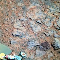
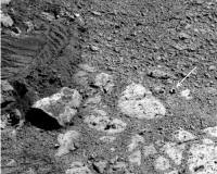
Posted by: mhoward Feb 10 2014, 05:41 PM
'Stuart Island', Opportunity Sol 3571 (L257)

|
Posted by: atomoid Feb 10 2014, 09:36 PM
wonder if Oppy cracked that rock driving over it.
little piles of soil dumped at intervals suggest PI could have been picked up along with soil to exit during one such dump and roll further downslope?

|
Posted by: serpens Feb 10 2014, 09:53 PM
Looks to me as though Pinnacle Island would fit into the missing piece at the top left of Stuart Island.
Posted by: jvandriel Feb 10 2014, 10:00 PM
The complete Navcam L0 view on Sol 3568.
Jan van Driel
|
|
Posted by: Phil Stooke Feb 11 2014, 03:25 PM
Nice pan, Jan!
This is the same pan in a circular format.
Phil

|
Posted by: serpens Feb 14 2014, 10:50 PM
There we go. PI mystery solved. http://www.jpl.nasa.gov/news/news.php?release=2014-051
Posted by: ngunn Feb 15 2014, 12:33 AM
The location may be solved but we still have two hypotheses for the formation of the bright componenet. It's either formed recently near the surface or it is a serendipitous exposure of something ancient. I'm going with number one. There is some water vapour in the air and it must go through cycles of condensation and sublimation. There will be an active layer at some depth where crystals form, like desert roses in Arabia. Maybe that layer is just a couple of centimetres down and we're seeing the products here.
http://i1.trekearth.com/photos/108334/_dsc4210_800.jpg
Posted by: Phil Stooke Feb 15 2014, 12:51 AM
On the other hand - that suggests the products should be found almost everywhere. An excavated stratum of unusual material could be much more limited in extent. Maybe mapping occurrences of rocks like this around the hilltop will help resolve the question.
Phil
Posted by: serpens Feb 15 2014, 02:51 AM
I think I would punt for number two ngunn. Given the miniscule absolute humidity and temperatures it is extremely difficult to see how manganese iron oxide crystals could form, recently, near the surface and internal to Stuart Island, which in itself is potentially an eroded out clast. The Manganese iron oxide crystals alone would seem to point towards a hydrothermal deposition. High magnesium and sulphur content implies a magnesium sulphate. No idea of the hydration state but there would be a high probability that this also formed by ground water mobilisation. We have seen enough kieserite since landing in Eagle crater to imply that water deposition from the atmosphere is effectively non-existent.
Posted by: fredk Feb 15 2014, 06:35 AM
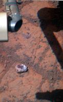
As atomoid reminds us, Oppy's lost bits of hardware before. But I don't think this is a nut, as much as it might look like one:
|
Probably just a fragment of rock from the PI-forming incident.
Edit: this frame from the current location just missed capturing the "nut" at higher resolution:
http://qt.exploratorium.edu/mars/opportunity/pancam/2014-02-10/1P445206735EFFCAGYP2538L5M1.JPG?sol3571
Posted by: Phil Stooke Feb 16 2014, 08:11 PM
The sol 3578 images:
http://www.midnightplanets.com/web/MERB/sol/03578.html
seem to show the right front wheel driving right over Pinnacle Island - an attempt to crush it, probably.
Phil
Posted by: mhoward Feb 16 2014, 08:40 PM
Hmm... I've been wishing they'd do that, but I think PI is still safely at the bottom of http://www.midnightplanets.com/web/MERB/image/03578/1F445826024EFFCAH4P1205R0M1.html, uncrushed, unless I'm missing something. Probably just repositioning, but I do hope they run over it again, and maybe crush some other rocks for good measure!
Posted by: Phil Stooke Feb 16 2014, 08:52 PM
Oh, right... there are later images, but it's another rock the wheel has probably run over.
Phil
Posted by: CosmicRocker Feb 16 2014, 09:21 PM
omg, all of this talk about the violent treatment of rocks has left me feeling faint.
Posted by: marsophile Feb 16 2014, 10:44 PM
http://marsrovers.nasa.gov/gallery/all/1/p/3567/1P444848968EFFCAFCP2535R7M1.JPG
The dark rock on the right looks different from this earlier image.
[EDIT: Sorry for being unclear. Comparing the above image to the image linked in mhoward's post:
http://www.midnightplanets.com/web/MERB/image/03578/1F445826024EFFCAH4P1205R0M1.html
there is a very dark rock that appears to have been crushed. That it is the same is evident from the bedrock underneath although the perspective is quite different. (I think the rock is in one piece in the prior image although it looks cracked and is partially in shadow.)]
Posted by: fredk Feb 17 2014, 03:40 PM
Which two images are you comparing, marsophile?
|
Posted by: marsophile Feb 17 2014, 06:59 PM
|
On second thoughts, it might be an illusion caused by the change in perspective. The rock looks pretty beaten up even in this earlier image.
Posted by: jvandriel Feb 17 2014, 07:04 PM
The Navcam images from Sol 3571 and Sol 3573 stitched together.
Jan van Driel
|
Posted by: atomoid Feb 18 2014, 09:49 PM
As an alternative to truly 'ancient' deposits (hundreds of thousands of years, rather than billions), might it be plausible for the source of humidity to be associated with a recent Milankovitch epoch, one in which an overlying snowpack drift accumulates against and outcrop and becomes buried by blowing sand to linger below the surface long enough to eventually interact and form deposits like this? and the non-ubiquity of such deposits be explained by the initial uneven formation and weathering in the intervening eons?
Posted by: ngunn Feb 18 2014, 10:30 PM
I appreciate both replies on this topic. Regarding the unusual elemental composition, undoubtedly that has to have arrived with the rock itself. That's no surprise. We know the sediments here contain fragments of many different types of source rock, no doubt from diverse locations traversed by the episodic flooding events. So far I'm with serpens. That said, I also think it's likely that atypical rocks that find themselves just centimetres below a freshly exposed surface as erosion proceeds will undergo at that stage more rapid changes than they have done during long term burial. In particular they will be subject to temperature variations and perhaps humidity cycles too: daily, yearly and astronomical (Croll-Milankovich). Also pH changes. So recent recrystallisation processes have to be considered a possibility.
Posted by: serpens Feb 19 2014, 03:38 AM
Temperature is a limiting factor for formation of manganese iron oxide so a bit more than snow or humidity would seem to be necessary. Other than hydrothermal, I guess the most likely mechanism would be formation of bixbyite in the high temperature, steam rich impact cloud when Endeavour formed. Both scenarios would explain the positioning in rim breccia.
Posted by: marsophile Feb 19 2014, 08:32 PM
Couldn't the manganese be in some form other than manganese iron oxide? For example, permanganate? How would that affect the possible genesis and the formation temperature?
Posted by: serpens Feb 19 2014, 09:13 PM
If they state that they identified manganese iron oxide then I think we can accept that that is what it is. Pity the Mossbauer ran out of oomph but they can be pretty definitive in this case using the APXS and visual MI.
Posted by: ngunn Feb 19 2014, 10:35 PM
I'm well out of my depth here on the mineralogy and happy to defer to more knowledgable posters, but I found a couple of things that may be relevant. First I note that bixbyite is a black mineral whereas the encrustation around the perimeter of Pinnacle Island is light toned (maybe white?), so perhaps we're talking about two different parts of the same rock. On another tack, I came across this: http://www.google.co.uk/url?sa=t&rct=j&q=&esrc=s&source=web&cd=3&ved=0CEEQFjAC&url=http%3A%2F%2Fwww.deas.harvard.edu%2Fenvironmental-chemistry%2Fpublications%2FIronManganeseScotMartin.pdf&ei=Wy0FU932FqSO7Qbc7ICABA&usg=AFQjCNFRIL0RnMcLzZoTIoUQE6sYyihbfg&bvm=bv.61535280,d.ZGU&cad=rja
Posted by: serpens Feb 20 2014, 06:40 AM
Ray Arvidson's statement that "The dark red stuff appears to be "iron manganese oxide of some kind," while the surrounding white part "represents some kind of sulphate." Given that Pinnacle Island has a high magnesium content, magnesium sulphate seems a likely contender. Hopefully all will be revealed at the next LSPC.
Posted by: jvandriel Feb 20 2014, 09:10 PM
The L0 Panoramic view from Sol 3578-3579-3581.
Jan van Driel
|
|
Posted by: mhoward Feb 24 2014, 12:32 AM
Wish for Opportunity to crush more rocks: granted. 'Sledge Island', Sol 3585
|
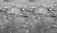
Posted by: atomoid Feb 27 2014, 10:12 PM
crosseye from http://www.midnightplanets.com/web/MERB/sol/03587.html 90-cw rotated MI pair centering on the topmost part of the crush zone highlighted in mhoward's post above.
|
Posted by: Phil Stooke Mar 1 2014, 05:05 AM
Oops, clumsy! They broke Stuart Island.
http://www.midnightplanets.com/web/MERB/image/03589/1P446801631EFFCB38P2545L4M1.html
Phil
Posted by: eoincampbell Mar 1 2014, 07:18 AM
Wow. Oppy does Karate!
Posted by: serpens Mar 1 2014, 08:52 AM
Amazingly fragile rocks.
Posted by: mhoward Mar 1 2014, 03:41 PM
"Nice rocks ya' got here. It'd be a real shame if something 'happened' to them..."
|
Posted by: brellis Mar 1 2014, 06:00 PM
Clouseau strikes again.
"That was a priceless rock!"
"Not any more."
Posted by: CosmicRocker Mar 1 2014, 08:56 PM
Hey Boss, http://imgur.com/fD5R7Xj?
Posted by: dvandorn Mar 1 2014, 09:10 PM
Tonight on Ethel the Frog, we look at Opportunity's obsession that she is being followed by an enormous indurated breccia named Spiny Norman...
-the other Doug
Posted by: atomoid Mar 3 2014, 09:39 PM
Oppy: "Aww, it was already cracked and would have fallen apart on its own,
|
|
Posted by: TheAnt Mar 3 2014, 09:49 PM
Monthy Phyton.
Posted by: fredk Mar 4 2014, 05:32 AM
Oppy's continuing to produce impressive power for this time of year - just past solstice and she's up to 464 Whr!
From the http://marsrovers.jpl.nasa.gov/mission/status_opportunityAll.html#sol3581
Posted by: MahFL Mar 4 2014, 11:45 AM
I did not know they were using the IDD to crush rocks.
Posted by: climber Mar 4 2014, 12:04 PM
Did you also note that people's pictures who write the updates didn't change till 2004? Oppy's still a young lady...
Posted by: RoverDriver Mar 4 2014, 03:31 PM
I didn't know it either, and I believe I was on shift that day...
Paolo
Posted by: Cruzeiro do Sul Mar 5 2014, 10:28 PM
From the http://marsrovers.jpl.nasa.gov/mission/status_opportunityAll.html#sol3581
Whoa!! This last update show a solar array dust factor of 0,691 when the lattest were 0,610;0,590 and 0,594. So, a relatively big cleening event had happened during this last week. Thanks to wind god of Mars (the same of earth; eole?).
Posted by: serpens Mar 6 2014, 01:45 AM
Good point Cruzeiro do Sul. It depends on which mythology you base the naming on I guess. In normal use here on Terra we tend to use the term Aeolian based on the Greek god of the winds Aeolus, although non traditionalists use eolian. But we are now discussing Mars and since that relates to the Roman god of war then we should probably use the Roman wind gods, Venti.
Posted by: dvandorn Mar 6 2014, 03:36 AM
Both mythologies are referenced in scientific jargon. For example, you'll see discussions of aeolian erosion forming ventifact rocks...
-the other Doug
Posted by: Phil Stooke Mar 6 2014, 04:48 AM
Aeolus held the winds in a bag. What did Venti keep them in? A really big cup?
Phil
Posted by: fredk Mar 6 2014, 05:03 AM
Some details about the recent dust cleaning (venti-lation?) in the latest http://www.planetary.org/explore/space-topics/space-missions/mer-updates/2014/02-mer-update-oppy-cruises-through-winter-solstice.html
Posted by: Astro0 Mar 6 2014, 06:04 AM
After reading that in the report I was immediately thinking about the way that sand blows off the top of a dune keeping it almost in continuous motion even in the lightest of winds.

|
Posted by: marsophile Mar 6 2014, 08:49 PM
I think the total tilt (vector sum of North/South and East/West) has been greater recently than at most times in the past. Perhaps that might account for the steady improvement? If this is so, then it might be useful to seek a tilt (perhaps East/West) even during other seasons besides winter.
Posted by: fredk Mar 6 2014, 09:18 PM
Spirit overwintered on the northern edge of Home Plate and got some pretty extreme tilts, but I don't recall any particular effect on dust coverage.
My guess is that the gravitational forces on dust on a tilted panel would be tiny compared to the wind forces.
Posted by: dvandorn Mar 6 2014, 09:42 PM
I don't think it's just a matter of tilt. It's more effective for dust cleaning to tilt into a prevailing wind, I think -- it increases the force of the wind for the surface to be more perpendicular to the airflow. Obviously, the edge of Home Plate wasn't an area where there was much prevailing wind. I'd guess there is more wind where Oppy sits now than there is down on the plains. I think the two -- a windy location plus a tilt into the wind -- worked together to create a gradual cleaning effect.
-the other Doug
Posted by: ngunn Mar 6 2014, 10:16 PM
That sounds right to me. A location where the hillside already faces into the wind plus an extra tilt of the panel in the same direction does the job. The dust is being swept upward off the surface, not sliding downward due to gravity, so tilting alone without the prevailing wind and the right topography would accomplish nothing.
The fact that this is a location where loose surface material is preferentially removed by wind may be part of the reason why we're at this spot.
Posted by: fredk Mar 6 2014, 10:31 PM
I'm still not convinced that the tilt is a factor here. I'd say that the wind along a slope is more or less parallel to the slope. If the wind was directed into the slope, the air would have to compress, which it doesn't do (significantly, anyway). Oppy's panels are tilted compared to level, but they are more or less parallel to the local slope. So the wind should be blowing more or less parallel to the panels, like it did when we were out on the plains.
But the topography could somehow give us stronger winds than we've seen before. Or turbulent lee eddies that might be good at cleaning dust of the panels.
Posted by: ngunn Mar 6 2014, 10:47 PM
I'm looking at Astro0's picture in post 191. Which way would you want to tilt to get your panels cleaned? I'd go for down slope and into the wind.
Posted by: serpens Mar 6 2014, 11:27 PM
I'm with fredk in that Opportunity's solar panels are always pretty much parallel to the terrain and wind. But despite lots of erudite articles and hypotheses the mechanism behind the cleaning events remains something of a mystery. From Larry Crumpler's contour map, during Opportunity's climb up the Solander ridge the topography would seem to put her in a zone of lower pressure and higher velocity. Yellow-bellied glider however raises the question as to what is a drift of pure dust doing in what should be a material removal zone? However, with the need for a northerly tilt for power, for much of the time it would seem that the solar panels would have been at a slight negative angle to the prevailing wind so turbulence, as suggested by fredk, does explain the continued removal, particularly if turbulence is a factor in the electrostatic charge of the dust.
Posted by: charborob Mar 10 2014, 02:30 AM
Sol 3596 mastcam pan:
|
Posted by: marsophile Mar 10 2014, 08:06 PM
Given the slow but steady dust removal, I wonder if it might be worth leaving the MiniTes window open again for a while in the hopes that the MT might be restored?
Posted by: Phil Stooke Mar 10 2014, 09:06 PM
They tried it so many times and it produced no results - probably it's not slow and steady dust removal that it needs, but a very energetic event, and they are completely unpredictable. I think we have to accept MTES is gone for ever. Don't forget that the open/close actions themselves involve extra planning time and sequence complexity.
Phil
Posted by: john_s Apr 22 2014, 06:21 PM
Looks like it's time to start a new topic
John
Posted by: Tesheiner Apr 22 2014, 07:36 PM
You're right John, and I just have created a http://www.unmannedspaceflight.com/index.php?showtopic=7836.
I will, most probably, be moving the latest pages because the "Winter campaing at Cook Haven" have already finished time ago and those posts would not belong here.
Edit: done.
Powered by Invision Power Board (http://www.invisionboard.com)
© Invision Power Services (http://www.invisionpower.com)