Printable Version of Topic
Click here to view this topic in its original format
Unmanned Spaceflight.com _ Opportunity _ Exploring Murray Ridge
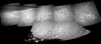
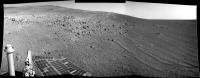
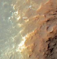
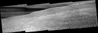
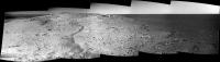
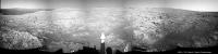
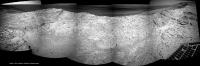
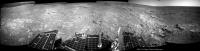
Posted by: charborob Mar 11 2014, 05:28 PM
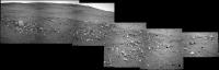
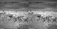
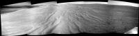
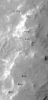
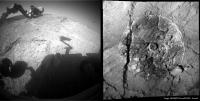
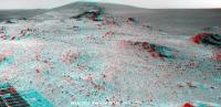
Sol 3600 right navcam pan:
|
---
Apr 24, 2014. This thread is dedicated to the rover activities after the winter campaign at / around Cook Haven. Moved several pages from that thread here.
Tesheiner (Moderator)
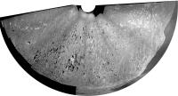
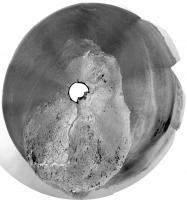
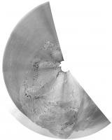
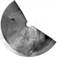
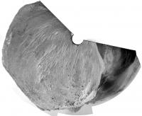
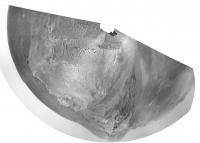
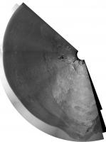
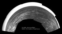
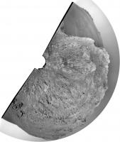
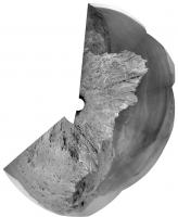
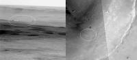
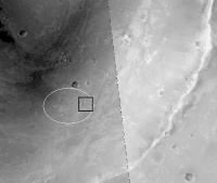
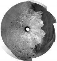
Posted by: Phil Stooke Mar 11 2014, 11:29 PM
Circular view of Charborob's pan.
Phil
|
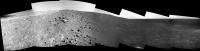
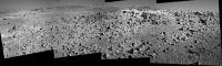
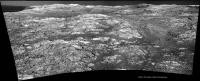
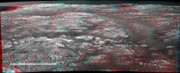
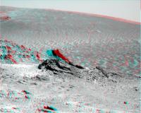
Posted by: jvandriel Mar 12 2014, 08:24 PM
The Sol 3600 Left Navcam view.
|
and the Sol 3601 Left Navcam view.
|
Jan van Driel
Posted by: atomoid Mar 12 2014, 09:30 PM
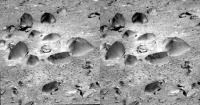
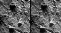
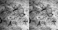
the surreal negative shading effect of filter 2 on the dusty little campfire ring rock garden from http://www.midnightplanets.com/web/MERB/image/03601/1P447864799ESFCBBWP2548L2M1.html
|
..seemed a good candidate for gif illusion (epileptics probably should NOT open)
|
Posted by: charborob Mar 12 2014, 10:43 PM
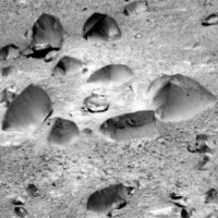
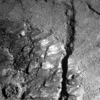
These rocks look like ventifacts.
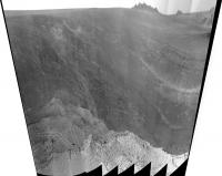
Posted by: serpens Mar 18 2014, 10:30 PM
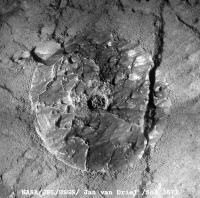
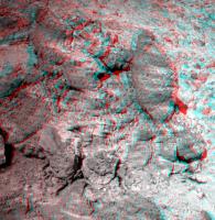
Curiosity might be getting all the attention but for me Opportunity remains the doyen of Mars rovers. Yet another change of scenery in the rock garden at McClure Beverlin West. Lithic breccia clasts eroding out of a sandy matrix?
|
Posted by: Explorer1 Mar 19 2014, 01:46 AM
Hey, when'd we drive to Gusev so fast? No one told me! 
Posted by: atomoid Mar 21 2014, 01:58 AM
sol3609: its nice to finally get a peek over the top

|
look! up in the sky, is it a cross-eyed cloud? is it schmutz? sort of, its just an amateur job at filling missing sky pixels.
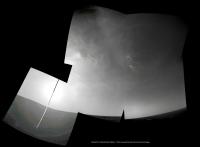
Posted by: Astro0 Mar 21 2014, 06:31 AM
Sol3609 - another fine day on Mars 
|
NB: Sky added for effect
Posted by: jvandriel Mar 21 2014, 01:42 PM
The Sol 3610 L0 Navcam view.
Jan van Driel
|
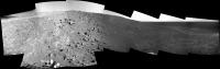
Posted by: jvandriel Mar 21 2014, 02:55 PM
The Navcam Lo view on sol 3608
|
and on Sol 3609
|
Jan van Driel
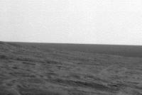
Posted by: fredk Mar 21 2014, 03:08 PM
I'm not sure exactly where we are, but I think this new view is just over a small ridge on Solander, and we can't yet see to the highest part of Solander, or beyond to Tribulation.
But we did see some real clouds tosol:
http://qt.exploratorium.edu/mars/opportunity/rear_hazcam/2014-03-21/1R448668353EFFCBH2P1305R0M1.JPG?sol3610
Posted by: jvandriel Mar 21 2014, 03:21 PM
For the complete view I have added the images from Sol 3607
to the panorama taken on Sol 3608.
Jan van Driel
|
Posted by: fredk Mar 21 2014, 03:32 PM
Actuallly I'm willing to guess where we are - this is not based on data at all, I just stared at navcams and the orbital view for a bit:
|
It makes sense as we head south to stay close to the plains-side of Solander - smoother driving and longer line-of-sight views for planning.
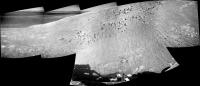
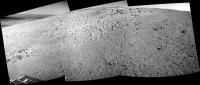
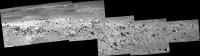
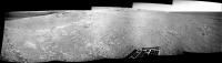
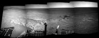
Posted by: charborob Mar 21 2014, 04:35 PM
Sol 3609 pancam pan (similar to jvandriel's pan but with one more image on the left side):
|
Posted by: Tesheiner Mar 21 2014, 06:00 PM

I just extracted the latest info from the pancam website and this is the result. I did no manual corrections at all for the time being but most probably will have to. Your guess based on the navcams should be more accurate.
|
Posted by: Phil Stooke Mar 21 2014, 09:13 PM
Right... that whole track needs to be shifted to the left about one diameter of that crater at the top left edge of the image.
Do we have enough images for a 360 pan from the recent stop at Augustine?
Phil
Posted by: jvandriel Mar 24 2014, 08:36 AM
Here is the complete panoramic view from images taken on Sol 3607 and Sol 3608
with the L0 Navcam.
Jan van Driel
|
|
Posted by: Phil Stooke Mar 25 2014, 03:20 AM
Fantastic - thanks. And with a little bit of geometric magic, it becomes a circular version of the area.
Phil
|
Posted by: fredk Mar 25 2014, 04:23 AM
Power levels http://marsrovers.jpl.nasa.gov/mission/status_opportunityAll.html#sol3603 - that was a good level at the best part of this past summer!
Posted by: serpens Mar 25 2014, 04:41 AM
Sparkly clean.
|
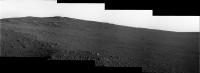
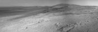
Posted by: charborob Mar 25 2014, 12:21 PM
Sol 3613 pancam pan:
|
Posted by: Ant103 Mar 25 2014, 02:10 PM
I don't totally forget Opportunity, and I found myself processing this color panorama of Sol 3609
http://www.db-prods.net/marsroversimages/Opportunity/2014/Sol3609_pancam.jpg
Posted by: jvandriel Mar 25 2014, 03:36 PM
The Pancam L 2 view on Sol 3613.
Jan van Driel
|
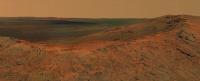
Posted by: Phil Stooke Mar 25 2014, 03:41 PM
Spectacular! What a great place. That picture just makes me think I could walk right up to that ridge and peek over it. It seems that we have still not seen the layers under the impact ejecta that we saw at Cape York (Whitewater etc.) - obviously we were very lucky to find that exposure. But there's lots more crater rim to explore.
Phil
Posted by: serpens Mar 25 2014, 04:28 PM
They identified those layers as the pre impact surface / sub surface, only a few metres above the Burns formation level, so I don't think we could reasonably expect to see it high on Solander. The interesting thing is that Larry Crumpler's LPSC paper identifies that the unconformity between impactites and the pre-impact surface had a dip of some 11 +/- 2 degrees towards the crater centre. This correlates quite nicely to Parker and Bills paper hypothesising that the bench does in fact reflect a previously level coastal geomorphology and there was subsequent tilting towards the crater. Circumstantial, but worthy of thought.
Posted by: Ant103 Mar 25 2014, 04:33 PM
Sol 3613 Pancam panoramic Is that some crater we have behind the crest ?
http://www.db-prods.net/marsroversimages/Opportunity/2014/Sol3613_pancam.jpg
Posted by: neo56 Mar 25 2014, 05:40 PM
Very nice mosaic Damia! Oppy is really doing mountain hiking
There is indeed what looks like a crater on the left part of your panorama. But I can't figure out where it is located on http://www.unmannedspaceflight.com/index.php?s=&showtopic=7790&view=findpost&p=208322.
Posted by: tedstryk Mar 25 2014, 06:01 PM
Is that some crater we have behind the crest ?Wow, beautiful! The best view from Oppy I've seen in a long time.
Posted by: fredk Mar 25 2014, 06:32 PM
Nice view indeed. I think this is the crater in question over the near crest:
|
I don't think we've moved much since the 3610 location.
Posted by: Phil Stooke Mar 26 2014, 02:07 PM
I agree with that crater location. And it was only a small move, 3 m or so.
Phil
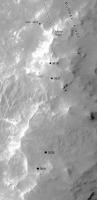
Posted by: atomoid Mar 28 2014, 01:09 AM
concur-o-gram
|
Posted by: atomoid Mar 28 2014, 11:28 PM
sort of interesting detail of "Turnagain Arm" back on sol 3598 makes me forget im not looking at a HiRise of kimberly
|
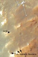
Posted by: Bill Mar 30 2014, 08:09 PM
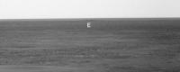
Any idea of what we are seeing West on the horizon ?
http://www.midnightplanets.com/web/MERB/image/03618/1N449387152EFFCC00P1777R0M1.html
|
|
Posted by: Phil Stooke Mar 31 2014, 02:57 AM
Not sure about that... but we are about here at the moment.
Phil
|
Posted by: PDP8E Mar 31 2014, 08:04 PM
Hi Bill,
Here is a Phil-O-Vision (10x stretch, vertical only) of that navcam 3618?

|
I don't know how to obtain azimuths from the pictures (some here do I think)
If I had a bearing we could consult a HiRise image for possibilities
First Guess:: it looks like a rock.
It is as dark if not darker that the surrounding 'horizon stuff', a more distant object could be lighter than the horizon material since there is more atmosphere and dust to see through.
cheers
Posted by: ngunn Mar 31 2014, 09:59 PM
I don't know if we can see out across the plains yet but if so there is a candidate small crater in that general direction that is quite prominent. I gave it the nickname Rockaway when we first saw it. It does look darker than its distance suggests.
Posted by: Phil Stooke Mar 31 2014, 10:47 PM
A little bogus-malogus colour image of Point Bede.
Phil
|
Posted by: jvandriel Apr 1 2014, 02:44 PM
The 360 degree Navcam L0 panoramic view on Sol 3618.
Jan van Driel
|
|
Posted by: jvandriel Apr 2 2014, 01:47 PM
and the Pancam L2 view on Sol 3618.
Jan van Driel
|
Posted by: atomoid Apr 3 2014, 09:24 PM
http://www.midnightplanets.com/web/MERB/sol/03621.html crosseye of biggest rocks Oppy has seen since......?
http://www.midnightplanets.com/web/MERB/sol/03621.html

|
Posted by: jvandriel Apr 4 2014, 11:08 AM
The Navcam L0 panoramic view on Sol 3621.
Jan van Driel
|
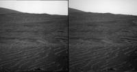
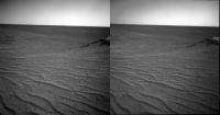
Posted by: fredk Apr 5 2014, 01:54 AM
Some crazy-looking "raked" or washboard terrain from pre-drive 3621:
http://qt.exploratorium.edu/mars/opportunity/pancam/2014-04-04/1P449640660ESFCC00P2560L5M1.JPG?sol3621
I assume we're just seeing lots of fine ripples perpendicular to the line of sight. The ripples are hardly visible in the corresponding navcam:
http://marsrovers.jpl.nasa.gov/gallery/all/1/n/3618/1N449386941EFFCC00P0673R0M1.JPG
That's the same nameless 5-10 metre crater we've been eyeing for some time now.
Posted by: fredk Apr 5 2014, 04:38 AM
And now we're almost at 90% dust factor! 
The cleanest panels since 2006!
From http://www.nmnaturalhistory.org/rover-field-reports-from-mars.html
Posted by: dilo Apr 5 2014, 05:37 AM
Very impressive!
As visible from following plots, in the last 5 years dust factor never went above 79.5% (record set on Sol 2313 or July 27, 2010):

|
Posted by: PaulM Apr 5 2014, 06:43 AM
From http://www.nmnaturalhistory.org/rover-field-reports-from-mars.html
This anouncement in Crumpler's post is very interesting:
"After we take a look at the local outcrops up here on the ridge crest, and maybe drive to the local summit for a good view of the crater, we will start driving south along the west side of the rim."
Given the uneven terrain on the Western side of the rim this means for the next few Years Oppy will always be within a few 100m of a North facing slope, which I think is a good decision
Posted by: dilo Apr 5 2014, 11:33 AM
In fact, they shows 3 possible paths in this region, while "next long-term target is about 600 m south along the west side of the crater rim"; however, the 10-26 sol drive time seems optimistic to me (unless they refers only to full, long drive sols!)
Posted by: fredk Apr 5 2014, 03:32 PM
But the path in question (path "A") stays away from the rough ridge of Solander and would probably be easy driving like out on the plains (and much easier than our climb up Solander so far). So that drive time sounds realistic, considering how fast we drove from Nobby's Head to Solander.
Of course in practice the limiting factor for the drive time will be the science stops.
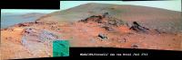
Posted by: charborob Apr 7 2014, 12:04 PM
Sol 3625 pancam filter 2 pan:
|
|
Posted by: vikingmars Apr 7 2014, 12:45 PM
Thanks a lot Charborob.
The view on the plains on the other side of the crater starts to be terrific ! I hope they will image it with the "L7" filter soon to gain more details far away. Thanks again
Posted by: James Sorenson Apr 7 2014, 02:14 PM
I'm working on processing the color images for the deck pan, but here is an L4 mosaic of what I got sofar.
https://flic.kr/p/mS7vMN
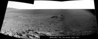
Posted by: charborob Apr 7 2014, 03:02 PM
The view on the plains on the other side of the crater starts to be terrific ! I hope they will image it with the "L7" filter soon to gain more details far away. Thanks again
Here is the left filter 7 pan on sol 3625 (the last image on the right is incomplete; I had to adjust the curves to make it more or less match the others). Are there really more details visible?
|
|
Posted by: Ant103 Apr 7 2014, 04:40 PM
Same view, in colors. Very good sighting there !
http://www.db-prods.net/marsroversimages/Opportunity/2014/Sol3625_pancam.jpg
Posted by: serpens Apr 8 2014, 03:09 AM
An interesting update from A. J. S Rayl.
http://www.planetary.org/explore/space-topics/space-missions/mer-updates/2014/03-mer-update-opportunity-powers-up-in-cook-haven.html
Posted by: craigmcg Apr 8 2014, 11:26 AM
Is there a map of "the bench" referred to in the above article?
Posted by: vikingmars Apr 8 2014, 01:36 PM
Thanks a lot Charborob ! Yes indeed : some craters on the far horizon are readily much more visible (as horizontal dark markings)
Posted by: centsworth_II Apr 8 2014, 06:11 PM

|
Posted by: jvandriel Apr 8 2014, 07:34 PM
The Pancam L7 view on Sol 3625.
Jan van Driel
|
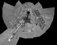
Posted by: James Sorenson Apr 8 2014, 10:48 PM
Almost finished with processing the color images that will be added to this but here is the L4 deckpan sofar.
https://flic.kr/p/mUWbd8
Posted by: James Sorenson Apr 9 2014, 05:37 AM
https://flic.kr/p/mVsP9dhttps://flic.kr/p/mVunTj
Posted by: neo56 Apr 9 2014, 08:52 AM
Really nice work James ! I didn't expect the solar panels to be so clean.
Posted by: Astro0 Apr 9 2014, 12:58 PM
Opportunity: Doing 'selfies' since 2004 

Posted by: Phil Stooke Apr 11 2014, 03:05 AM
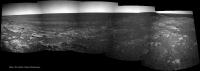
A long-awaited moment (by me at least) - Cape Tribulation viewed over the top of Murray Ridge:
http://www.midnightplanets.com/web/MERB/image/03630/1N450443541EFFCCJ3P1835L0M1.html
Phil
Posted by: ngunn Apr 11 2014, 07:51 AM
Long awaited by me as well. I'm looking out for another glimpse of the Miyamoto 'Mule Ears' off to the SSW. They were not visible in navcams before but we're a bit closer now. There are some camdidate bumps among the noise but nothinjg more so far. I'm hoping that the planned panorama from the local summit will be a full 360 and not just the view into the crater.
Posted by: jamescanvin Apr 11 2014, 08:02 AM
Yay! I was hoping that this drive would finally reveal it and there it is. Nice to see where we're going. 
Posted by: Dig Apr 11 2014, 09:54 AM
Panorama on Murray Ridge. Sol 3630. Navcam left.
https://flic.kr/p/mZi9cD
https://flic.kr/p/mZi9cD
Posted by: Astro0 Apr 11 2014, 10:06 AM
Just wondering if any of our mapping gurus (Tesh, Phil etc) would be able to point to places on the horizon that would be headings for craters like Santa Maria, Victoria etc?
Not expecting them to be visible, just interested in directions.
Posted by: Phil Stooke Apr 11 2014, 03:19 PM
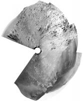
Great pan, Dig - here's a circular view of it to help locate us on the hill.
Phil
|
Posted by: mhoward Apr 12 2014, 01:43 AM
http://marsrovers.jpl.nasa.gov/mission/status_opportunityAll.html#sol3622

Posted by: eoincampbell Apr 12 2014, 04:44 AM
I wonder just how much more spectacular it could get  ...
...
Posted by: Ant103 Apr 14 2014, 04:43 PM
Sol 3633 Pancam panoramic. The view is astounding ! We can see Cape York there !
http://www.db-prods.net/marsroversimages/Opportunity/2014/Sol3633_pancam.jpg
Posted by: Floyd Apr 14 2014, 07:42 PM
Nice, I love the tracks winding up the hill!
Posted by: jvandriel Apr 14 2014, 08:12 PM
The Navcam L0 view on Sol 3632.
Jan van Driel
|
Posted by: jvandriel Apr 14 2014, 09:00 PM
Pancam L7 panorama of the wheeltracks on Sol 3632.
Jan van Driel
|
|
Posted by: Phil Stooke Apr 15 2014, 12:00 AM
Great view, Damia - here's a stretched perspective view of it to make it easier to identify things.
Phil
|
Posted by: brellis Apr 15 2014, 01:42 AM
The ~absolutely gorgeous~ pic assembled by Ant103 in http://www.unmannedspaceflight.com/index.php?s=&showtopic=7790&view=findpost&p=208709 shows the crater I've always wanted to be named the Far Side Crater in honor of Gary Larsen. True?
Fun fact - I premiered a concerto for electronic keyboards and orchestra with the LA Phil in 1989. Someone taped this cartoon to the curtain where I was to pass thru to receive my soloist's applause. LOL
It's the higher crater, IIRC.
Posted by: Ant103 Apr 15 2014, 02:33 PM
New pictures are down today, the occasion to complete the full panoramic over Endeavour crater
http://www.db-prods.net/marsroversimages/Opportunity/2014/Sol3633_3634_pancam.jpg
Thank you James
Posted by: jvandriel Apr 15 2014, 07:58 PM
The complete 360 degree Navcam L0 panoramic view taken on
Sol 3630 and Sol 3632.
Jan van Driel
|
|
Posted by: James Sorenson Apr 16 2014, 07:49 AM
My take sofar on the Endeavour Pan. There is a circular donut area on the left most part of the Pancam images that at leased for me isn't removable with current flat-fields unless however I brush them out. I have noticed this for quite awhile.
https://flic.kr/p/namSER
Posted by: ngunn Apr 16 2014, 10:03 AM
Now as I was hoping we see the horizon to westward included in the pan. I assume the blip near the middle of this image is the same feature discussed in posts 235-8 above but still awaiting firm ID.
http://qt.exploratorium.edu/mars/opportunity/pancam/2014-04-15/1P450891819EFFCCLCP2415L7M1.JPG
I see no very distant features here such as Bopolu or Miyamoto. Perhaps we're still not high enough even on this summit, or perhaps the air is just not clear enough at present.
Posted by: charborob Apr 16 2014, 04:08 PM
Sol 3635 navcam view:
|
We're almost at the top!
Posted by: atomoid Apr 16 2014, 05:30 PM
http://www.midnightplanets.com/web/MERB/image/03635/1P450891393EFFCCLCP2415R1M1.html dune texture makes for interesting xeye
|
Posted by: Phil Stooke Apr 16 2014, 07:57 PM
A circular semicircle from sol 3635, just west of the prominent crater at the top of the ridge.
Phil
|
Posted by: ngunn Apr 17 2014, 08:18 AM
Thanks Phil. From your circular pan we can now see that the blip on the horizon is on a bearing close to 241 degrees. This means it can't be 'Rockaway' which should be near 272 degrees. My best guess for the blip is now a crater about half the size of Victoria and about 15 km distant. If I'm matching up the contour map with CTX correctly that crater and 'Rockaway' are located on the same gentle N-S rise which I think forms our western skyline from this viewpoint.
Posted by: neo56 Apr 17 2014, 05:00 PM
@James : really nice colour mosaic! I'm looking forward to the final panorama
@atomoid : there is a really good 3D effect on your xeye particularly between the foreground and the background. I love these little dunes
Posted by: atomoid Apr 17 2014, 10:42 PM
So the 'blip' crater would seem to be this apparently younger one (arrow), not the eroded scalloped one (Rockway?) closer in.
|
@neo56: if only I could get the clumsy sw I have to not mangle the seams, I was trying for a bit wider vantage of that scene..
Posted by: James Sorenson Apr 18 2014, 01:04 AM
I've been doing some minor fine tuning of control points in my rover deck pan template and I added the rest of the images. Still some fine tuning left to do. Here is the L4 mosaic. The JPL version looks great
|
EDIT: Whoops! sorry please move this post.
ADMIN: Done!
Posted by: ngunn Apr 18 2014, 06:35 AM
Atomoid: That's the one I'm suggesting but I'm using nothing more sophisticated than a school protractor laid on my computer screen. I'm awaiting confirmation or just as likely correction by someone with better tools. I note that this crater has wind streaks extending southeastward from each side suggesting there is significant relief there. The larger crater farther east is more eroded and furthermore lies in a hollow so I don't expect to see it.
[Incidentally 'Rockaway' is not that crater but the much smaller fresh one that appears as a dark spot at the top of your image almost directly above the arrowed feature. If you're interested you can find its original ID in post 259 of 'Distant Vistas' and a good view of it from near Concepcion in post 201 of that same thread.] EDIT: And the contour map in post 123.
Posted by: ngunn Apr 18 2014, 08:58 AM
Maybe I'm wrong about that. Checking the latest images I see a feature which could be that crater just below the horizon and just to the right of the foreground slope: http://qt.exploratorium.edu/mars/opportunity/pancam/2014-04-18/1P451066065EFFCCMZP2417R1M1.JPG
Posted by: jvandriel Apr 18 2014, 02:50 PM
The Navcam L0 view on Sol 3635.
Jan van Driel
|
|
Posted by: jvandriel Apr 18 2014, 03:08 PM
and the one on Sol 3637.
Jan van Driel
|
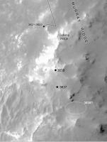
Posted by: Phil Stooke Apr 18 2014, 04:08 PM
I really like this ripply landscape, believe it or not. Here's a circular version of Jan's nice panoramic view for sol 3637, and a map showing where we are.
Phil
|

|
Posted by: ngunn Apr 18 2014, 04:23 PM
Here is an enlarged crop showing the dark streak close to the horizon that I think may be part of the 'Victoria-twin' crater 8 km to the SW of us. I say part because the whole thing should subtend a horizontal angle of about 6 degrees or one-third of a pancam image.
|
Posted by: atomoid Apr 18 2014, 09:34 PM
selected ripply http://www.midnightplanets.com/web/MERB/image/03637/1N451065275EFFCCMZP0725R0M1.html pair stereo. tried to make stereo pan but my tools (and chops) cant handle making the needed adjustments that work so well in http://www.unmannedspaceflight.com/index.php?s=&showtopic=7790&view=findpost&p=209086 fine work, im including sample at right below anyway if for no other than comedic purposes.
|

|
Posted by: PDP8E Apr 18 2014, 10:11 PM
Here is an image of the objects on the WSW horizon.
It is from Pancam on sol 3635
I rotated the image 4.66 degrees CW to get the horizon level(ish).
I then used a high pass filter (line detector with 6 pixel radius) to accentuate the darks (darker) and brights (brighter) at the high frequency pixels on the horizon, and then stretch it vertically (Phil-O-Vision).
A histogram of a high pass filtered image is centered on DN 128 and is normal, with long tails
the object on the right looks like a crater
note the smaller (smaller? farther?) object on the left

|
Posted by: ngunn Apr 19 2014, 07:10 AM
The size you show for the crater is right, I think, for a 500m crater at 15km.
Regarding the smaller feature on the left, the topography suggests that it should be at a similar distance. There is indeed a smaller crater a bit to the east of the 500m one, as seen here, on a line with the 'Victoria-twin':
http://marsrover.nasa.gov/gallery/press/opportunity/20090318a/CTX_Mosaic_notext.tif
Posted by: charborob Apr 19 2014, 07:05 PM
Nice pancam view of Cape Tribulation on sol 3637:
|
Posted by: Ant103 Apr 19 2014, 07:58 PM
In colors
http://www.db-prods.net/marsroversimages/Opportunity/2014/Sol3637_pancam.jpg
Posted by: jvandriel Apr 20 2014, 06:04 PM
The Navcam L0 view on Sol 3639.
Jan van Driel
|
Posted by: Phil Stooke Apr 20 2014, 07:01 PM
Checking in from the UK with a circular version of Jan's pan. I still haven't located it.
Phil
|
Posted by: fredk Apr 20 2014, 10:36 PM
Leave town for a week and suddenly it looks like a new mission! Stunning pans everyone.
I don't know exactly where we are but I think we've moved to the SE somewhere into this area on 3639:
|
This is based mainly on a knob on the near eastern horizon getting larger between 3637 and 3639.
Posted by: Phil Stooke Apr 21 2014, 05:46 PM
Got it - here we are, a big drive south. I only have a location, not a route.
Phil

|
Posted by: fredk Apr 21 2014, 07:26 PM
Yep, that looks right. What a long drive!
Posted by: vikingmars Apr 22 2014, 08:48 AM
Trying to find my way as a mountain hiker...
==> Dear Phil here are 2 pics :
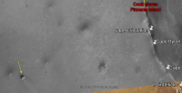
- one taken far away at Sol 2295 and showing Murray Ridge : it appears as an elongated hill with 2 distinct summits, the 2nd being the highest :
|
|
- one taken Sol 3637 with a quick picture interpretation to show where the two summits of Murray Ridge may be located :

|
Correct me if I'm wrong but we are nearing the 1st summit and we need now to travel to the 2nd summit before reaching the best vantage point...
There, we will take the best panoramic pictures with a gorgeous view on the slopes of Cape Tribulation !
Thanks again for your nice maps
Posted by: craigmcg Apr 22 2014, 11:52 AM
Seems like the "winter haven" is behind us?
Posted by: jvandriel Apr 22 2014, 02:17 PM
It looks like Opportunity is on the 1st summit on Sol 3641.
Jan van Driel
|
Posted by: fredk Apr 22 2014, 03:04 PM
As Viking's first pic shows, the "first summit" is very broad and flat, but since we can see over it now it does look like we've crested it.
The "second summit" is along the clay signature we're headed for, and with these energy levels we could get there fast...
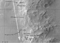
Posted by: Phil Stooke Apr 22 2014, 09:16 PM
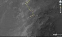
Here's a circular version of the 3641 mini-pan to show where we are, and a map showing the location (I am deliberately not drawing this up as a full map and putting it in the route map thread because I don't want to take over the 'official' Opportunity mapping)
Phil
|
|
Posted by: Floyd Apr 22 2014, 11:19 PM
Hi Phil or any other cartographer--could you post a larger context image of all of Murray Ridge or Murray Ridge and Tribulation (either here or in the map thread). In the map thread I went back a dozen or more pages and could not find a helpful context map. The map of the all of Endurance is too large--sorry to be picky.
Thanks in advance fredk [how did I know fredk would post--must be a time warp]
Posted by: fredk Apr 23 2014, 12:14 AM
http://photojournal.jpl.nasa.gov/catalog/PIA17072 extends just a bit into Tribulation.
Posted by: charborob Apr 23 2014, 11:02 AM
Sol 3642 navcam pan: clear view of Cape Tribulation.
|
Posted by: craigmcg Apr 23 2014, 11:47 AM
I'm sure this was posted here before, but as we get closer to the big clay signature it seemed worth a second look.
http://www.nasa.gov/mission_pages/mer/multimedia/gallery/pia13708.html
Also, one of many papers you get by searching the web for papers on the topic:
http://www.planetary.brown.edu/pdfs/3954.pdf
Posted by: fredk Apr 23 2014, 03:21 PM
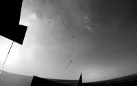
Very nice cloud sequence on 3640, eg
http://qt.exploratorium.edu/mars/opportunity/navcam/2014-04-23/1N451342424EDNCCQOP1567L0M1.JPG?sol3640
There are four good cloud images that piece together in pairs (I can't see the two pairs fit together). Definitely an advanced stitching job for our resident experts, considering cloud movement and stretching differences...
On another topic, http://www.lpl.arizona.edu/~lemmon/mars-tau-b.html have plummetted down close to 0.2 recently, which is very low for this (or any) time of year. There's always some potential degeneracy with dust factor which relies on modelling to resolve, but still this is probably as good as it gets for imaging distant features.
Posted by: Ant103 Apr 23 2014, 04:21 PM
I'm on it
Beautiful clouds there !
|
Posted by: Phil Stooke Apr 23 2014, 05:00 PM
Latest position and a reprojected pan originally from Charborob.
Phil
|
|
Posted by: dvandorn Apr 23 2014, 07:24 PM
Yep -- and I believe that the brighter cloud arc to the right of the (not imaged) solar disc may well be a sundog. Looks like a subtle arc forming a portion of a halo around the sun, not directly associated with the cloud structures.
Cool!
-the other Doug (with my shield, not yet upon it)
Posted by: fredk Apr 23 2014, 07:55 PM
Doug - any chance you could point to your arc candidate on an image?
Posted by: Deimos Apr 23 2014, 08:05 PM
fredk: I would bet on tau retroactively jumping up within a week or so. The reported values are quite extraordinary.
Posted by: dvandorn Apr 24 2014, 12:59 AM
Sure. Here's a piece of the cloud mosaic; the black arrows point to the top and bottom of the arc that I'm seeing. I put a green bracket to the left of the arc I'm seeing, as well.
Now, the thing that makes it look like a sundog to me is that in the middle of the arc, it looks like the cloud structure is unchanged but that it glows more brightly than to the right or left, or even up and down the ring arc a bit. That would be the center of the sundog on the right side of the sun.
I've seen the same kind of thing here on Earth thousands of times, and this looks like the same thing to me...
-the other Doug (with my shield, not yet upon it)
|
Posted by: djellison Apr 24 2014, 01:14 AM
I doubt it's a sun-dog/halo. Those are 22 degrees from the sun usually, and this looks to be at least one NavCam FOV (45 deg) from the sun
Simulations here http://www.atoptics.co.uk/halo/owmars.htm
More likely an internal reflection from the camera
Posted by: fredk Apr 24 2014, 01:15 AM
Should a sundog be at the same elevation as the sun? Your feature appears to be a fair bit higher than the sun - I think most of the horizon in this view is the distant, true western horizon.
Posted by: dvandorn Apr 24 2014, 03:21 AM
OK, kewl. I didn't have a really good way to measure the angular distance from the solar disc. Thanks for that.
-the other Doug (with my shield, not yet upon it)
Posted by: dvandorn Apr 24 2014, 03:29 AM
Honestly, I was looking at the mosaic and thinking that the solar disc was not imaged, was behind the cut-outs on the upper left side of the mosaic. Looking more closely, it does indeed look like the solar disc is imaged (and completely saturates the pixels around it), rather farther down towards the horizon than I was thinking it should be.
Also, isn't Oppy on a slope? I thought perhaps that what looks like horizontal in the image really isn't because the horizon may not be horizontal where she's sitting. With an undulating horizon from a tilted rover, I wasn't very positive that a different distance above the horizon equated to a different elevation.
Again, though, thanks for the comments, guys. It looked like a sundog to me more because of the way the little arc sort of glowed in mid-arc, which does indeed resemble the sundog phenomenon. Dunno if that's an artifact of the mosaicing process or, as Doug suggested, an internal camera reflection, but it did fool me.
-the other Doug (with my shield, not yet upon it)
Posted by: Ant103 Apr 24 2014, 05:28 AM
You have to know that the bright cloud at the center of the image is not really bright, it's an artifact of fusion between frame during the export of the panoramic. It was pretty hard to stitch and to correct the exposure between frames. So the result may not be perfect .
Posted by: jamescanvin Apr 24 2014, 08:00 AM
So if we assume that tau is unlikely to be really as low as 0.2 then does that imply a Pancam cleaning event?
Posted by: fredk Apr 24 2014, 03:12 PM
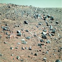
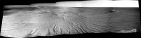
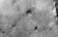
Nice view of a ~100 metre crater out on the plains:

|
I'm surprized we're not seeing Bopolu/Miyamoto rims, considering the low tau and our elevation above the plains. They should be roughly towards the southwest. Maybe there's a subtle ridge to the SW that's blocking our view now, but didn't back in the early sol-2000's when we could see them clearly.
Posted by: Phil Stooke Apr 24 2014, 04:30 PM
A circular fragment of a pan for 3643.
Phil

|
Posted by: ngunn Apr 24 2014, 06:03 PM
I don't think we are that high actually, certainly not as high as when those features were last visible. Here is the link back to Peter Grindrod's contour map: http://www.unmannedspaceflight.com/index.php?showtopic=6438&view=findpost&p=156005. Incidentally I wonder if you can either confirm or improve on my tentative IDs of horizon features in posts 84-96 (the week you were away)?
Posted by: jvandriel Apr 24 2014, 07:20 PM
The Navcam L0 view on Sol 3643.
Jan van Driel

|
Posted by: Phil Stooke Apr 24 2014, 07:36 PM
The new location on sol 3643. I call one crater X15, but I don't know which one it really is. This one is surrounded by blocks. Maybe it's really the more distant one indicated by Fredk. When I know I will fix the map if necessary.
Phil

|
Posted by: atomoid Apr 24 2014, 11:44 PM
nice crater view on sol3643, I don't see x15 in any3643 pancams but it may be the big smudge in this http://www.midnightplanets.com/web/MERB/image/03642/1N451507552EFFCCV4P0734L0M1.html navcam before checking out the trampled ripples..

|

|
Posted by: jamescanvin Apr 25 2014, 07:32 AM
I think you are right Phil. Based on the pointing data I beleve it's the blocky nearby one.
Posted by: Phil Stooke Apr 25 2014, 01:50 PM
Here's a circular pan view of the 3644 location - between the two little craters on a north-south line on the map. The southern crater is seen in this view.
Phil

|
PS I'm in Salisbury for a family visit - not too far from you, James!
Posted by: jvandriel Apr 25 2014, 02:59 PM
The Sol 3644 Navcam L0 view.
Jan van Driel

|
Posted by: fredk Apr 25 2014, 05:33 PM
I think you're right - some higher-resolution contour plots in http://www.unmannedspaceflight.com/index.php?s=&showtopic=6788&view=findpost&p=166793 show better that we're still not as high as we were back around the early sol 2000's. We may need to get a substantial ways up Tribulation before we'll see features like Miyamoto/Bopolu.
About the feature on the SW horizon, I'm skeptical that it's the suggested crater ("A" in my image below), even though the diameter seems to fit as you pointed out. On 3643, the feature lined up with the right side of the much closer ~100 metre crater I posted about above, "D". Sighting along the right edge of "D" takes us well south of "A", see lower line here:
|
Crater "A" should appear well to the right of "D", see upper line. Crater "B" is another possibility. But I think the horizon feature is actually the much closer crater "C". It lines up nicely with "D" and is on a subtle ridge according to the contour plots and has the right width to match the horizon feature.
Posted by: ngunn Apr 25 2014, 06:03 PM
Nice work on the horizon feature and thanks for taking the trouble. There are only a few of us mad enough to care about such a small blip  but I do like knowing how far away the horizon is! Quite close seems to be the answer. It should be easy to confirm your identification by the change in bearing as we move south.
Posted by: jvandriel Apr 25 2014, 08:03 PM
Here is the complete 360 degree Navcam L0 panoramic view from Sol 3639.
Jan van Driel
|
|
Posted by: fredk Apr 26 2014, 10:51 PM
One more crater ID - what appears to be a cluster of craters:
|
is 21 degrees right of the left rim of crater "C", matching the cluster labelled "E":

|
The cluster may appear to be closer than "C", but I think that's just because we can see a much more distant ridge behind "E" that's not visible behind "C".
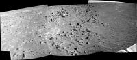
Posted by: charborob Apr 27 2014, 08:22 PM
Sol 3644 pancam view of Lunokhod2 crater:

|
Posted by: jamescanvin Apr 29 2014, 11:02 PM
Here is the full L456 mosaic of Lunokhod 2 Crater (it's been a long time since I've done this, I'm rather out of practice!)

|
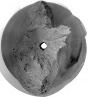
Posted by: Phil Stooke Apr 30 2014, 05:38 PM
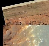
70 m drive on sol 3649 - here's a circular mini-pan (Navcams supplemented by one pancam)
Phil

|
and the approximate location:

|
Posted by: ngunn Apr 30 2014, 08:01 PM
I hope it's just the first of many more to come.
Anybody know why the Lunokhod 2 name was chosen for this crater? Is it related in any way to odometry?
Posted by: Phil Stooke Apr 30 2014, 08:17 PM
Not to breaking the record specifically. Lunokhod 1 is just a short distance further north. My estimate is that there is about 3 km to go before a record can be claimed.
Phil
Posted by: Phil Stooke May 1 2014, 08:22 PM
Quick circular pan - or a quarter of a pan anyway. I'm having trouble finding an exact location with such a small area.
EDIT - two more pics, now I can locate it. I replaced the earlier image with a larger circular pan, and here's the location.
Phil

|

|
Posted by: atomoid May 2 2014, 09:31 PM
http://www.planetary.org/explore/space-topics/space-missions/mer-updates/2014/04-mer-update-opportuniry-roves-next-to-clay-mine.html on planetery.org . Now I want a 3D printer..
Posted by: mhoward May 3 2014, 08:17 PM
There is a May 2 update at http://www.nmnaturalhistory.org/rover-field-reports-from-mars.html (nmnaturalhistory.org) that has a nice oblique drive map, showing the path right up to the Al-OH area just ahead, and looking beyond to 'smectite valley' (probably not an official name).
The http://www.midnightplanets.com/web/MERB/image/03650/1P452220988EFFCC%23%23P2426L7M1.html look intriguing.
Posted by: fredk May 4 2014, 01:07 AM
Yeah, and that field notes blog says:
And the planetary update had this interesting bit about the cleaning events:
Posted by: Ant103 May 4 2014, 12:14 PM
Some Navcam panorama I wanted to stitch, just for the beauty of the site
Sol 3643
http://www.db-prods.net/marsroversimages/Opportunity/2014/Sol3643_pano.jpg
Sol 3649. Notice the pretty clean solar panels
http://www.db-prods.net/marsroversimages/Opportunity/2014/Sol3649_pano.jpg
http://www.db-prods.net/marsroversimages/Opportunity/2014/Sol3649_pano2.jpg
Posted by: Phil Stooke May 4 2014, 10:25 PM
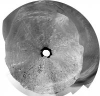
Great pans - and now we have new pictures from 3653, and we are on the rocks. Beautiful. Here's a quick circular view. I want to see a bit more before mapping a location.
The orientation is not correct (north-up), but I will fix it when I have more to go on.
Phil

|
Posted by: charborob May 4 2014, 11:47 PM
Sol 3653 navcam pan:

|
Posted by: Ant103 May 5 2014, 12:08 AM
Sol 3653 Navcan panoramic.
http://www.db-prods.net/marsroversimages/Opportunity/2014/Sol3653_pano.jpg
Posted by: vikingmars May 5 2014, 07:32 AM
WOW ! Thanks Phil, Charborob and Damia !
"Yum - yum" for all those rocks : this is all I can say !
This is indeed a brand new mission and it was worth the trip
Posted by: charborob May 5 2014, 08:35 PM
Sol 3654 navcam pan:
|
Posted by: Dig May 6 2014, 09:28 AM
My version. Opportunity Right Navcam Sol 3654
Increased slightly contrast to better see the details a little cleaning and denoise.
https://flic.kr/p/nvx1ox
Click on image for full size
And polar projection
|
Click on image for full size
Posted by: Phil Stooke May 6 2014, 06:01 PM
The half-pans over the last two sols fit together to make a full one - here's a circular version giving a really clear view of where we are right now.
Phil
|
Posted by: Dig May 6 2014, 06:17 PM
From my previous panorama, I tried to make a simulated composition including a 3D model of the rover. The orientation is not faithful. The rover size is based on the distance and spacing of the footprints in the ground for the placement of the vehicle and give an idea of the approximate scale in the context of the image. I also added a backlight to give a touch of drama to the image.
The post is not intended to be exactly realistic. It is only a test.
Anyway, I think it has been well enough to share it in the forum. Hope you like it.
https://db.tt/MIQ9qZpE
Click on image for full size or this https://db.tt/MIQ9qZpE
Posted by: James Sorenson May 7 2014, 08:05 AM
Nicely done Dig!
Did you make the 3D rover model if I may ask?
Posted by: jvandriel May 7 2014, 09:54 AM
The Navcam images taken on Sol 3653 and Sol 3654 stitched together.
Jan van Driel
|
|
Posted by: Dig May 7 2014, 08:34 PM
Did you make the 3D rover model if I may ask?
Thank you James.
Regarding the 3D model, it is not mine. I searched and found one free. Not much detail, but enough for what I needed. You can find it here.
http://tf3dm.com/3d-model/mars-rover-spirit-opportunity-97893.html
Regards
Posted by: fredk May 8 2014, 12:29 AM
It looks like a sunset ND sequence:
http://qt.exploratorium.edu/mars/opportunity/pancam/2014-05-07/1P452587488ESFCC__P2654L8M1.JPG?sol3654
http://qt.exploratorium.edu/mars/opportunity/pancam/2014-05-07/1P452588460ESFCC__P2654L8M1.JPG?sol3654
Posted by: charborob May 8 2014, 01:13 AM
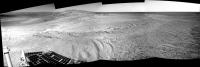
Sol 3655 navcam pan:
|
Posted by: Ant103 May 8 2014, 10:37 AM
My take There is some clouds to the right part of the panoramic :
http://www.db-prods.net/marsroversimages/Opportunity/2014/Sol3655_pano.jpg
Posted by: Phil Stooke May 8 2014, 04:54 PM
This is a circular version of Damia's half pan from sol 3655.
Phil
|
Posted by: charborob May 9 2014, 07:43 PM
Sol 3658 r-pancam filter 2:
|
Posted by: vikingmars May 9 2014, 10:39 PM
Thanks a lot Charborob, this is an incredible landscape !
Posted by: jvandriel May 10 2014, 11:47 AM
The Pancam L2 and R2 view on Sol 3658 in Stereo.
Jan van Driel
|
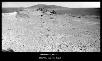
Posted by: charborob May 11 2014, 01:11 AM
Sol 3659 navcam pan:
|
(Panorama is a bit crappy, but the scenery is fantastic.)
Posted by: Phil Stooke May 11 2014, 08:27 AM
Yes indeed, fantastic. I added the partial frame at the right end of your pan and made a circular version of it. Some little veins cutting the rock here and there. Also - where I think we are now.
Phil
|
|
Posted by: jvandriel May 11 2014, 11:21 AM
My view of the Sol 3659 Navcam L0 images.
Jan van Driel
|
|
|
|
Posted by: dvandorn May 11 2014, 12:34 PM
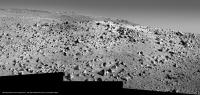
More than just about anywhere else here at Meridiani (or even at Gusev or Gale), this area looks like it was a heavily populated block field which has been worn down to just the nubs of boulders after eons of wind erosion.
This appears to go beyond Steve Squyres' "dog's breakfast" of eroded, jumbled rocks. This area was a huge GIANT dog's breakfast...
-the other Doug (with my shield, not yet upon it)
Posted by: Ant103 May 11 2014, 01:02 PM
My take on this pan, it's a wonderful view
http://www.db-prods.net/marsroversimages/Opportunity/2014/Sol3659_pano.jpg
UPDATED
Posted by: centsworth_II May 11 2014, 02:59 PM
Posted by: serpens May 11 2014, 11:13 PM
Indeed they do, although if this is uplift rim it is a little difficult to correlate to the contention that at the much lower Cape York Matijevic Formation, the contact represented the pre impact surface. Could we possibly be looking at an overturned rim here being the pre-Endeavour sub surface?
The view is superb and I love the contrast between the fall away into the crater to the East compared to the gentle Western slope of the Meridiani onlap.
Posted by: Dig May 12 2014, 10:30 AM
Great! Damia
Posted by: ngunn May 12 2014, 02:07 PM
Are we all that much higher in fact? Even if we are a little higher I don't see much of a problem. We can't assume the pre-Endeavour surface was horizontal to start with, or that different portions of the rim were necessarily uplifted by equal amounts.
Posted by: Phil Stooke May 12 2014, 08:51 PM
Yes, a beautiful place, and that new full panorama is spectacular, Damia. Here's a circular version.
To me these rocks look like the impact breccias (AKA ejecta) on Cape York. There are lots of clasts embedded in the rocks right in front of us.
Phil
|
Posted by: serpens May 12 2014, 11:08 PM
NPREVs point that the height difference is not all that great is well taken, however as Phil points out this is a clastic breccia, akin to the Cape York Shoemaker formation whereas the Matejevik original surface was fine grained. My query about potential overturned rim was prompted by a niggling question as to whether, given the low solubility of aluminium, there would be sufficient groundwater in the rim to enable aluminium hydroxide to form. If not then this could imply a pre-impact formation.
Posted by: dvandorn May 13 2014, 01:12 AM
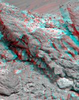
Yep, that's exactly why it looks to me like this used to be a blocky ejecta field that has been eroded down to the ground, so to speak. Because the base rocks all appear to be highly brecciated.
I appreciate the comments, though -- to let a small cat out of the bag, I'm in the middle of a very difficult recovery from the first of two major abdominal surgeries. (The second surgery will happen as soon as I'm well enough recovered from the first one, and I keep developing post-op infections that are getting badly in the way of my recovery). This means that I have had more time and such to read and post to the forum -- but it also means that, at least at times, I'm on some pretty serious painkillers. I check anything I post three or four times to make certain it's not the product of a drug-addled brain, but just to let y'all know, if I post something that seems more incoherent than normal for me, it's likely because of the ocycodone.
But anyway, thanks Phil, I'm happy to see that I'm not the only person who noticed that the base rocks here at Murray Ridge all seem to be breccias, implying this is the remnants of a thickly bouldered ejecta field.
-the other Doug (with my shield, not yet upon it)
Posted by: Floyd May 13 2014, 09:45 AM
Doug--It is a real fight sometimes. Keep your shield up and know we are shoulder to shoulder with you.
Regards, Floyd
Posted by: Ant103 May 13 2014, 11:00 AM
Sol 3633 & 3634 pancam panoramic, now in colors
http://www.db-prods.net/marsroversimages/Opportunity/2014/Sol3633_3634_pancam.jpg
Posted by: vikingmars May 13 2014, 12:56 PM
How nice ! Thanks a lot Damia
Posted by: serpens May 13 2014, 10:59 PM
Beautiful Damia. The view from a height, combined with a bit of colour really helps put the crater and the encroachment of the sulphate sandstone into perspective. Cape York looked quite impressive from orbital images and towered over the landscape in initial DEM presented in this forum, but were it not for the bench one could easily overlook it in the panorama.
Posted by: charborob May 14 2014, 02:37 AM
Sol 3662 navcam pan:

|
Moving a bit closer to the edge.
Posted by: GeoMartin May 14 2014, 08:09 AM
It is impressive how clearly we can see now in this panorama (more to the right) the ejecta and rim of Iazu crater. Even a the cliff-like feature at the northern edge of the ejecta blanket is visible. Furthermore, it appears its rim is pretty "spiky".
The atmosphere seems to be very clear at the moment, so maybe we can see even more distant features if opportunity reaches the top of Endeavour's rim ...
Posted by: Ant103 May 14 2014, 08:54 AM
Thanks
Sol 3662 Navcam panoramic. A very neat place
http://www.db-prods.net/marsroversimages/Opportunity/2014/Sol3662_pano.jpg
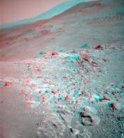
Posted by: Phil Stooke May 14 2014, 11:19 AM
Phil checking in from Heathrow on my way to Washington ...
Fantastic views from up here! The view north to Cape York in the Pancam mosaic is the best yet, and gives us the best view ever of the subdued crater north of Cape York, known as Antares, even showing dunes on its floor. I won't show it here as I'm a bit limited in what I can do right now.
Phil
Posted by: Art Martin May 14 2014, 03:09 PM
There are some large boulders down in the main crater floor below the far rim. I can't get a real sense of their scale from just gawking. Anyone have an idea just how big they are?
Posted by: Ant103 May 15 2014, 08:01 AM
Sol 3663 pancam of the outcrops at the crest.
http://www.db-prods.net/marsroversimages/Opportunity/2014/Sol3663_pancam.jpg
Posted by: RoverDriver May 15 2014, 03:50 PM
At 22Km, each PANCAM pixel is about 5.25 meters tall/wide.
Paolo
Posted by: Phil Stooke May 17 2014, 10:21 AM
This location has been named Pillinger Point in the descriptions of the latest Pancam images. Nice!
Phil
Posted by: ngunn May 18 2014, 07:34 AM
In this image there is a bright smudge near the horizon directly above the rightmost end of Cape York. I don't see it in images from a few days ago:
http://qt.exploratorium.edu/mars/opportunity/navcam/2014-05-17/1N453637490EFFCDAHP0783L0M1.JPG
Posted by: Astro0 May 18 2014, 09:02 AM
Gust of wind perhaps?

|
Posted by: fredk May 18 2014, 02:46 PM
Good eye. It does look like a gust.
Posted by: Eutectic May 18 2014, 10:51 PM
Phil
For those who may have missed the reference, Colin Pillinger was the colorful principal investigator for the Beagle 2 mission. He died on May 7th.
Posted by: GeoMartin May 19 2014, 07:58 AM
These objects look very interesting! But do these boulder-like features have to be http://en.wiktionary.org/wiki/allochthonous necessarily? Maybe they are old remnants of a sedimentary layer that once covered the crater floor. These objects are very big and located pretty far from the steep slope of the crater rim. I am not sure if they could have moved so far on a relatively even surface. Furthermore, we can see in CTX datasets in the southwestern part of the crater floor a little cliff-like feature of a sedimentary layer that has to be http://en.wiktionary.org/wiki/autochthonous. It is in close proximity to these boulders.
So these boulders might be some knobs of a former sedimentary layer?
Posted by: MahFL May 19 2014, 12:05 PM
Oh crumbs he died....
Posted by: fredk May 19 2014, 04:37 PM
My identification of the large blocks we're seeing now:
|
Posted by: Phil Stooke May 19 2014, 04:57 PM
Good identification, fredk, and I would refine it slightly based on some reprojections I played with, to these hills.
Phil
|
Posted by: fredk May 21 2014, 01:50 AM
This is incredible - 761 Whrs and dust factor 0.964! From the latest http://marsrovers.jpl.nasa.gov/mission/status_opportunityAll.html#sol3657.
Posted by: Zeke4ther May 21 2014, 03:03 AM
Wow!
Posted by: eoincampbell May 21 2014, 04:02 AM
Remarkable! And the further she climbs...
Posted by: serpens May 21 2014, 05:18 AM
That is sparkly clean. They did not start publishing the dust factors until around sol 1776 but I would assume that it would have only been a matter of a few sols after landing before the dust factor dropped below this level.
Posted by: Explorer1 May 21 2014, 06:09 AM
So still in Eagle crater? Ah, the memories.
Now the question of whether to credit this to the Martian atmosphere, the mission planners, the local geology (for being so enticing), or all three...
Posted by: James Sorenson May 21 2014, 06:52 AM
Here is a segment of the Pillinger Point pan.
https://flic.kr/p/npsnbt
EDIT:
https://flic.kr/p/nptdcy
Posted by: neo56 May 21 2014, 07:58 AM
Thanks James for this beautiful mosaic! Now I have a new wallpaper
Posted by: vikingmars May 21 2014, 01:07 PM
James, this is a beautiful result, knowing that the filters are aging and the original pics from which you worked are very saturated. Thanks again !
Posted by: tedstryk May 21 2014, 01:45 PM
EDIT:
Just wow.
Posted by: James Sorenson May 22 2014, 03:02 AM
Thank you all for the comments!
Another segment.
https://flic.kr/p/nq1mDT
Posted by: neo56 May 22 2014, 07:37 PM
The black rock at the bottom right of James' mosaic intrigues me. What could be its composition?
Posted by: James Sorenson May 22 2014, 11:25 PM
I'm at work right now, so away from my home computer, but if I recall in the false color images, it was a bluish color. Usually but not always blue roughly translates to a basaltic in origin in the false color images. I'll have to make a false color version. But making any sort of mineral composition judgement from the raws I don't really like to do.
Posted by: James Sorenson May 23 2014, 01:27 AM
Here is a false color of that rock, it's actually pretty dark which in my opinion also looks a bit interesting, not just this particular rock but this whole site.
|
Posted by: eoincampbell May 23 2014, 02:03 AM
Really appreciate your treatments of the Pillinger Point views, thanks James...
Posted by: James Sorenson May 23 2014, 01:38 PM
Thank you
A screenshot of two of the 3 sections roughly positioned together in Photoshop before stitching together.
https://flic.kr/p/nqR32V
Posted by: James Sorenson May 24 2014, 09:49 PM
A screenshot of the false color version of this magnificent place
https://flic.kr/p/nJbaeg
Posted by: Astro0 May 25 2014, 06:42 AM
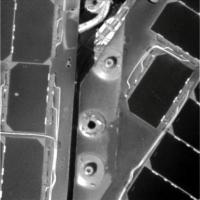
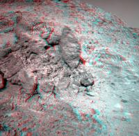
Sol 3671 - Brushing and MIs at Pillinger Point.
GIF animation:
|
Hazcam and MI mosaic
|
Another GIF animation (flicker):
|
Posted by: jvandriel May 25 2014, 07:42 AM
The Mi cam view on Sol 3671.
Jan van Driel
|
Posted by: vikingmars May 26 2014, 03:50 PM
James, please forgive me : I could not resist balancing back your wonderrful panorama into real Martian colors !
Thanks again so much for your nice work
|
Posted by: James Sorenson May 26 2014, 06:28 PM
Good job! I don't mind at all, I'm just waiting for the rest of the images to arrive to complete it.
Posted by: Julius May 28 2014, 01:09 AM
I suppose that Meridiani should be darker in colour but there certainly is a big difference the way MARS looks from pictures taken by Opportunity at Meridiani and Curiosity at Gale. I wonder how real that difference is!
Posted by: James Sorenson May 28 2014, 05:49 AM
I just want to say I'm not claiming of coarse that this is an accurate representation of the colors. For the Raw stretched JPG images, it's more of an art and a guessing game. There are several factors that contribute to the color difference, but I'd say roughly you should compare the colors of Gale with Spirit, or Mars Pathfinder landing sites. But I want to stress, use the calibrated PDS images if you want to do comparison work, not the raw images for MSL or MER.
Posted by: charborob May 29 2014, 04:03 PM
Sol 3677 navcam pan:
|
Moving away from the edge.
Posted by: charborob May 30 2014, 03:46 PM
Sol 3678 navcam pan:
|
|
Posted by: Phil Stooke May 30 2014, 05:32 PM
This is a circular version of Charborob's new panorama. I fixed a few bad bits on the horizon - and missed one, I see now (Charborob, I think if you can get a tie point near the horizon in each seam you can avoid that step effect).
Anyhoo - this lets me identify the location accurately. Next week I will try to post a map of the activities in this area.
Phil
|
Posted by: Dig May 30 2014, 07:54 PM
My version. Opportunity Navcam Right · Sol 3678
http://bit.ly/RPDjhN
Posted by: charborob May 30 2014, 08:27 PM
Sorry about that. But I am making my panoramas using PhotoShop, and it stitches the images automatically without me having to specify tie points. On the other hand, sometimes I get those stitching errors.
I suppose I should be using Hugin or other stitching software for better results. I am making a trade-off between optimal results and rapidity. I tried Hugin, but it asks me for control points, and I don't have the time to specify a bunch of those. It seems a complicated process overall, and I can't invest the necessary time and effort.
Posted by: Phil Stooke May 30 2014, 08:29 PM
OK! Sorry about that. I've never tried Photoshop for stitching.
Phil
Posted by: fredk Jun 3 2014, 02:55 PM
Great stereo views from near the edge now available:
|
Posted by: James Sorenson Jun 3 2014, 04:24 PM
Finally the last image came down just a little bit ago, now I present to you Pillinger Point and Endeavour Crater.
https://flic.kr/p/nNZrr9
http://www.gigapan.com/gigapans/156060
False Color:
https://flic.kr/p/nyxfbH
http://www.gigapan.com/gigapans/156061
Posted by: elakdawalla Jun 3 2014, 07:18 PM
What an awe-inspiring view! Thanks for assembling it, James.
Posted by: vikingmars Jun 3 2014, 08:05 PM
How nice ! Congratulations and thanks a lot James !
Posted by: Dig Jun 4 2014, 07:32 AM
Awesone James! Amazing landscape and wonderful colors.
Now I have a new wallpaper for my monitor.
Congratulations.
Posted by: jvandriel Jun 6 2014, 08:49 PM
The Navcam L0 view on Sol 3678.
Jan van Driel
|
|
Posted by: jvandriel Jun 9 2014, 06:16 PM
and the view on Sol 3684.
Jan van Driel
|
|
Posted by: serpens Jun 9 2014, 11:04 PM
AJS Rayl has provided another information packed summary for Opportunity.
http://www.planetary.org/explore/space-topics/space-missions/mer-updates/2014/05-mer-update-opportunity-hunts-ancient-clays.html
Posted by: Phil Stooke Jun 11 2014, 12:13 AM
Weird... the newest images include a target called Cape Upright... but the same name was used back on sol 3598.
Phil
Posted by: Phil Stooke Jun 12 2014, 11:59 PM
A circular pan - made from Jan's latest panorama, sol 3684.
Phil

|
Posted by: jvandriel Jun 13 2014, 07:21 PM
and here is the Navcam L0 view on Sol 3691.
Jan van Driel
|
|
Posted by: Phil Stooke Jun 14 2014, 12:56 AM
Creeping along the top of the ridge! Here's a circular view of Jan's pan just above. By com paring these with HiRISE I am mapping out the route - I will post something on it next week.
Phil

|
Posted by: vikingmars Jun 15 2014, 06:17 PM
Thanks a lot Jan van Driel for this nice panorama and to Phil for the 360° "donut" pan : we have not yet arrived to the top of the 2nd summit, but are now definitely standing above the 1st summit !
|
|
Posted by: charborob Jun 18 2014, 01:02 PM
Sol 3696 navcam view:
|
|
Posted by: Phil Stooke Jun 18 2014, 02:21 PM
Nice! Here's a circular version of it which lets me find the location.
Phil

|
Posted by: fredk Jun 20 2014, 02:56 AM
Quick and dirty noise subtraction from two of the transparency test frames:

|
I don't recognize the field. This could be done a lot better by looking at multiple frame combinations etc...
Posted by: Gerald Jun 20 2014, 11:22 AM
Assuming the vertical streaks to be mostly stars, here a try to remove some of the noise from FredK's diff:

|
Edit: Tried to identify a couple of stars (mainly constellation Libra) :

|
Posted by: Gerald Jun 21 2014, 01:10 PM
After more accurate combining of the three Sol 3697 nightshots:

|
After registering the three (edit: cleaned) images, summing, and rotating 3.5 degrees, I've used a 7x5-linear kernel of (1,4,6,4,1)-rows to enhance vertical bright lines, cleaned from CRs by intesecting four vertically displaced copies (0,8,16,24 pixel displacement), halved brightness to - once again - apply the linear operator, and subtracted the brightness bias of the linear filter. Annotated the most evident stars.
Posted by: jvandriel Jun 22 2014, 01:40 PM
The Navcam L0 view on Sol 3698.
Jan van Driel
|
|
Posted by: Phil Stooke Jun 22 2014, 03:58 PM
Great! Here's a circular reprojection of it to help locate the rover.
Phil

|
Posted by: jvandriel Jun 23 2014, 09:19 PM
The Navcam L0 panoramic view on Sol 3701.
Jan van Driel
|
|
Posted by: James Sorenson Jun 25 2014, 01:49 AM
JPL released their version of the Pillinger Pan!
http://www.nasa.gov/jpl/mer/pia18393/#.U6onf7EuLSg
note: I noticed a reddish cast to the black background which I assume is a color correction after merging the pan onto the background. For my viewing I just set the black point to the black background and that fixed that.
Posted by: tedstryk Jun 25 2014, 08:06 PM
Nice to see, but are they not going to complete the panorama?
Posted by: Phil Stooke Jun 25 2014, 08:37 PM
Not from there, anyway - they've moved on. There are lots of partial panoramas in the collection.
Phil
Posted by: fredk Jun 26 2014, 04:21 AM
The view of Tribulation is starting to get spectacular as we approach the 2nd summit:
http://qt.exploratorium.edu/mars/opportunity/pancam/2014-06-25/1P456930983EFFCE00P2439R1M1.JPG?sol3703
Posted by: James Sorenson Jun 26 2014, 04:29 AM
Hopefully a color Pancam pan will be taken soon.
Posted by: atomoid Jun 26 2014, 10:44 PM
Spectacular view coming up indeed.. since the MER thread has an 'unmanned'  map thread these days, here's a blind stab at trying to get a fix on where we are... in the ballpark?

|
Posted by: Phil Stooke Jun 26 2014, 11:49 PM
Yes, you're about right. I will post something when I have time.
Phil
Posted by: mhoward Jun 27 2014, 02:28 AM
I usually don't cross-post here, but I though this right Pancam view was just wonderful.

|
Posted by: James Sorenson Jun 27 2014, 04:13 AM
I agree! I'm gonna be working on that one next.
The Sol- 3700 3x1 mosaic
https://flic.kr/p/o7GXxq
Posted by: Phil Stooke Jun 27 2014, 03:46 PM
This is Jan's panorama from sol 3701 in circular form to help locate the rover. I will update the route map soon.
Phil

|
Posted by: fredk Jun 29 2014, 03:00 PM
In the latest post by http://www.nmnaturalhistory.org/rover-field-reports-from-mars.html there's a pancam view that shows what I assume is an overlaid proposed route up Tribulation (green dashed line). That route goes up behind the spectacular knob-ridge-crater structure on the near slopes of Tribulation that we're now getting a great view of. If we took that route the views would be absolutely stunning!
Of course as always that's got to be a tentative route. There's text on the image which seems to suggest two possibilities are being considered:
-or summit CT to see upper Shoemaker?
Posted by: Ant103 Jun 29 2014, 04:02 PM
Sol 3703 Pancam color pan. It truly is a wonderful landscape
http://www.db-prods.net/marsroversimages/Opportunity/2014/Sol3703_pancam.jpg
Posted by: jvandriel Jun 30 2014, 07:56 PM
The Navcam L0 panoramic view on Sol 3705.
Jan van Driel
|
|
Posted by: jvandriel Jul 2 2014, 02:10 PM
and the Navcam L view on Sol 3710.
Jan van Driel
|
|
Posted by: SpaceListener Jul 2 2014, 02:51 PM
Wonderfull picture to permit us to have a great view of Mars' landscape.
Posted by: fredk Jul 2 2014, 03:12 PM
Impressive "tooth" to our south (at the south end of the 2nd peak, I believe). Anaglyph:

|
And cross-eyed:
|
|
Posted by: ngunn Jul 2 2014, 04:31 PM
It is an impressive sight, at least from this direction. Could somebody point to it on a HiRise crop?
EDIT Thanks for the post below - very helpful.
Posted by: fredk Jul 2 2014, 05:26 PM

|
Posted by: jvandriel Jul 3 2014, 12:52 PM
Nice view on Sol 3711.
Jan van Driel
|
Posted by: jvandriel Jul 3 2014, 02:53 PM
and the same view in stereo.
Jan van Driel

|
Posted by: Floyd Jul 3 2014, 02:53 PM
Can't wait to drive up to these beautiful Shark's Teeth. Notice the one on the right is about to exfoliate with another underneath.
Posted by: Explorer1 Jul 3 2014, 10:56 PM
June updated by A.J.S. Rayl: http://www.planetary.org/explore/space-topics/space-missions/mer-updates/2014/06-mer-update-opportunity-nears-end-of-murray-ridge.html
Oppy may have set the traverse record already, but they're still triple-checking before any big announcement....
Posted by: atomoid Jul 4 2014, 12:56 AM
the road behind and ahead http://www.midnightplanets.com/web/MERB/image/03711/1N457634077EFFCEE1P1825R0M1.html in crosseye

|

|
Posted by: fredk Jul 4 2014, 01:58 AM
A description of the possibilities for the future route from that update:
Posted by: Phil Stooke Jul 5 2014, 03:16 AM
This is Jan's 3710 panorama in circular format.
Phil

|
Posted by: Phil Stooke Jul 5 2014, 03:25 AM
And the previous one from sol 3705.
Phil

|
Posted by: fredk Jul 5 2014, 02:35 PM
After another drive closer to the big tooth on 3713, the view of Tribulation is starting to open up:
Anaglyph:

|
Cross-eyed:

|
Posted by: jvandriel Jul 5 2014, 05:15 PM
The Navcam view on Sol 3713.
Jan van Driel
|
|
Posted by: jvandriel Jul 5 2014, 06:03 PM
Sol 3713 in stereo.
Jan van Driel
|
Posted by: Phil Stooke Jul 6 2014, 03:42 AM
Beautiful, Jan. Here is your full panorama from sol 3713 in circular form.
Phil

|
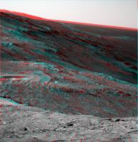
Posted by: fredk Jul 6 2014, 04:55 PM
Spectacular!
|

|
Posted by: marswiggle Jul 6 2014, 05:47 PM
And this pair to the left of above came down in separate days, so that not everyone perhaps noticed it exist in stereo. Spectacular as well!

|
Posted by: SFJCody Jul 6 2014, 06:26 PM
Today's shots are lovely. It occurs to me that if they do climb Cape Tribulation they should get a good look at Iazu to the south.
Posted by: jvandriel Jul 6 2014, 07:20 PM
The Sol 3713 Pancam view in colour with some data missing.
Will be added later.
Jan van Driel
|
Posted by: jvandriel Jul 8 2014, 02:18 PM
The Sol 3716 navcam view in stereo.
Jan van Driel

|
Posted by: fredk Jul 8 2014, 02:39 PM
And a closeup of the black tusk, tweaked a bit to bring out some shadow detail.
Anaglyph:

|
Cross-eyed:

|
Posted by: Phil Stooke Jul 8 2014, 05:36 PM
Black Tusk - good name! Midnight Planets is calling it Fin - or is it just a fin? For people who don't know, Black Tusk is up in the mountains north of Vancouver.
I will update the Opportunity close-up map in a day or two.
PS - road trip update, I'm now in Victoria, BC, staying put for a few weeks except for a trip to Vancouver for the RASC talk. If Opportunity could drive like me we would be almost at Tharsis by now.
Phil
Posted by: mhoward Jul 9 2014, 12:23 AM
I'm remembering that Kirkwood was originally labelled "fin".
For others: "Kirkwood" was the outcrop in front of "Whitewater Lake", the one that contained the fascinating "newberries".
Posted by: James Sorenson Jul 9 2014, 05:38 AM
My take on the incredible view on Sol-3713.
https://flic.kr/p/og4DWe
Posted by: vikingmars Jul 9 2014, 12:36 PM
How nice !!! Thanks a lot James !
Posted by: jvandriel Jul 9 2014, 02:14 PM
Downhill on Sol 3717.
Jan van Driel
|
Posted by: fredk Jul 9 2014, 03:14 PM
Impressive drive on 3717 right up to the base of Black Tusk/Fin.
Anaglyph:
|
Cross-eyed:
|
Also it looks like some mid-drive pancam imaging:
http://qt.exploratorium.edu/mars/opportunity/pancam/2014-07-09/1P458169048EFFCEIZP2548R2M1.JPG?sol3717
And we now have a completely clear (and very scenic) view of the approach to Tribulation:
http://qt.exploratorium.edu/mars/opportunity/navcam/2014-07-09/1N458171252EFFCEJMP0735R0M1.JPG?sol3717
Posted by: jvandriel Jul 9 2014, 07:07 PM
Added 5 images.
Jan van Driel
|
|
Posted by: walfy Jul 9 2014, 07:34 PM
Another great rock formation from recent sol:
|
Posted by: walfy Jul 9 2014, 07:41 PM
Nice glimpse of inner rim of Endeavor:
|
Posted by: fredk Jul 9 2014, 08:58 PM
It looks like those pancam shots were mid-drive imaging of Black Tusk/Fin. What a place this is.
Posted by: jvandriel Jul 10 2014, 01:50 PM
Nice navcam view on Sol 3718.
Jan van Driel
|
|
Posted by: Phil Stooke Jul 10 2014, 02:42 PM
I thought we would spend some time at Fin - but it did look like more breccia.
Phil
Posted by: fredk Jul 10 2014, 03:09 PM
I place the 3718 location here, based on some of the little ripples around us now:

|
It does look like "drive, drive, drive"!
Posted by: Phil Stooke Jul 10 2014, 06:00 PM
You're right, fredk, and here's a circular projection of Jan's panorama to prove it.
Phil
|
Posted by: Zeke4ther Jul 10 2014, 06:36 PM
So, do we know yet what route has been chosen to get to the "smectite valley"?
I think I saw something from L. Crumpler that indicates that Opportunity will be doing some hill climbing.
Posted by: vikingmars Jul 10 2014, 06:42 PM
Me too ! I'm deceived we did not take a 360° pan from this vantage point : I think we missed a very nice & spectacular view with Fin at the foreground...
It would have been great for doing good EPO !
Posted by: walfy Jul 11 2014, 06:40 AM
More beautiful breccia from sol 3717:
|
Powered by Invision Power Board (http://www.invisionboard.com)
© Invision Power Services (http://www.invisionpower.com)