Printable Version of Topic
Click here to view this topic in its original format
Unmanned Spaceflight.com _ Opportunity _ Past Bahia Blanca
Posted by: glennwsmith Feb 8 2007, 06:16 AM
Tesheiner, I read about the 10K mark, and was hoping that you had updated the route map to show the excursion that put us over the mark -- and you didn't disappoint!
By the way, I'm thinking that Oppy's getting ready to head back to Duck Bay, which looks like the past entry path, plus nice vertical cliffs to examine on the way in . . .
Posted by: glennwsmith Feb 8 2007, 06:17 AM
Of course I meant best entry path . . .
Posted by: dvandorn Feb 8 2007, 07:52 AM

I don't know about that. I think from what Squyres has said, they're more likely to enter the crater in the next three or four bays.
I'm thinking that this last drive, up and away from the rim, is a set-up for a short sprint straight east into the dark streaks. Oppy can then work south towards the rim through the major dark streak, characterizing the soils outside the streak, inside the streak, and along the boundaries.
-the other Doug
Posted by: djellison Feb 8 2007, 08:10 AM
They're going a funny way about it....and why would you pick an entry point after seing less than 1/4 of the rim, especially when we've been told they plan to cover something like 120 degrees of crater rim.
Doug
Posted by: kenny Feb 8 2007, 09:16 AM
Maybe they're heading for that crater on the annulus with the pale east rim, then on to the first dark streak? Clealry, they are mssing out Cabo Corrientes. From the area where the first streak meets the rim of Victoria, they'd get a good view of the boulder field inside the crater, the biggest and best collection of tumbled-down rock anywhere inside Victoria. They come from the beds of the layered cape above it (Cape D 1). My guess is they'd like to use those boulders to sample different layers of the strata in the crater wall.
Kenny
Posted by: Tesheiner Feb 8 2007, 09:33 AM
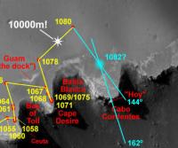
Mmm, I would guess they are still planning to drive onto Cabo Corrientes.
Here is the rationale: The "post-drive" mosaics taken on sol 1080 were headed at 144º, meaning that the rover driver's primary interest for the next move is centered on that heading. In other words, it might be possible that the next move is on heading 144º i.e. towards Cabo Corrientes.
Now, the next move is already planned; it's on sol 1082 (today). Among the planned imaging sequences is, again, the "post-drive" navcam mosaic this time centered at 162º. Based on the previous assumption that today's move will be headed at 144º and (another assumption) the post-drive navcam mosaic is centered on the cape tip, I did the following picture with Opportunity's possible (?) location after today's move.
My two cents.
|
OT: FWIW, sol 1082 activities include one more Phobos transit imaging session.
Posted by: kenny Feb 8 2007, 12:10 PM
Tesheiner, I'm sure you're right about the clues given by the imaging instructions. But I can't understand why they went so far away from the rim to the 1080 position, only to turn around and double back in again, when there's nothing that requires such a big avoidance maneuver. The route from 1078 to 1080 is at an azimuth of about 50 degrees, whereas something about 80 degrees would have taken Oppy much more quickly and efficiently towards Cabo Corrientes.... unless they've gone out there to look at something.
K
Posted by: djellison Feb 8 2007, 12:52 PM
Because they had better drive-direction visibilty that way and could be sure of zero hazards over a longer drive that way? Because they wanted to get some navcam terrain model wedges to augment the ones they will get closer to the rim and build a better model of this area? Because they wanted to test some long distance autonomous driving far from the rim? Loads of reasons why they'd do it. How close to the edge of a jagged cliff do you walk.....blind fold

Doug
Posted by: MarkL Feb 8 2007, 12:58 PM
If you look at the point reached on sol 1066, you can see that it is also further than apparently necessary away from the crater. They are likely searching for a vector to the cape tip that minimizes the chance of falling off an edge. It may be because they are testing auto-navigation and want to give the computer a margin of safety.
Whether the rover goes 20, 30 or 40m on a drive, it can still easily complete it in the time required by the plan so it probably doesn't matter a whole lot (unless you are counting wheel revs) how far they drive.
.
Posted by: fredk Feb 8 2007, 06:42 PM


Posted by: Tesheiner Feb 9 2007, 09:05 AM
> I love how you've got your projected path taking us right onto Hoy, Tesheiner!
We can dream, can't we?
Imaging info from yestersol move (1082) already made their way to the PCDT web, but the exploratorium have no new pics yet. A minor hiccup I would say.
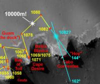
Assuming the mobility data is accurate (and it usually is), this is Opportunity's new position:
|
I will update the route map once we have some pics.
Edit: Doug, would you mind to rename this thread "Past Bahia Blanca, onto Cabo Corrientes" or similar?
Posted by: kenny Feb 9 2007, 09:46 AM
Looking at the 1082 position, we couldn't really fault Tesh's prediction, could we !!??
Posted by: elakdawalla Feb 9 2007, 04:53 PM
Done!
-- not Doug
Posted by: climber Feb 9 2007, 10:20 PM
No need to explain Eduardo : we just can't get to "Hoy" after "manana". We've got to go to "ayer" first
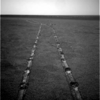
Posted by: jvandriel Feb 10 2007, 06:31 PM
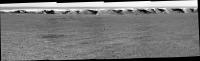
A look in the drive direction on Sol 1080.
Taken with the L2 Pancam.
jvandriel
|
Posted by: fredk Feb 10 2007, 07:00 PM
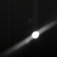
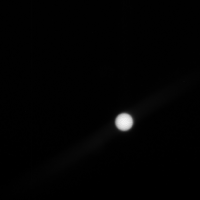
On sol 1082 Oppy took a curious looking Phobos eclipse sequence - the movement of Phobos looks odd, almost as if it changes direction! I think what happened was the sun was slightly overexposed (notice also how the sun is slightly elongated), and somehow that caused the weird apparent motion. Local time was around 14:25, frames are 3 seconds apart.
|
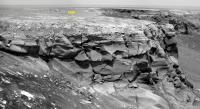
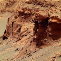
Posted by: jvandriel Feb 10 2007, 08:20 PM
The view in the drive direction ( crater rim ) on Sol 1082.
Taken with th L2 Pancam.
jvandriel
|
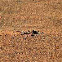
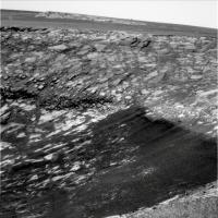
Posted by: Floyd Feb 10 2007, 09:51 PM
There are lots of rocks scattered around on the surface--more rocks from space? 
Posted by: djellison Feb 10 2007, 09:59 PM
Courtesy of JB....
1082B
|
Posted by: nprev Feb 10 2007, 10:11 PM
Hard to say, but I wouldn't be a bit surprised...Meridiani seems more & more like the "Allan Hills" of Mars, but I bet the ice caps are even more fun!
Doug, thanks to you & JB for the enhancement of the eclipse sequence...makes sense now.
Posted by: Stu Feb 11 2007, 08:44 AM
Another mini martian "strewn field" of fallen star stones for meteorite collectors here on Earth to drool over... 
|
Posted by: dilo Feb 11 2007, 10:40 AM
Sol1084, colorized stitch of 3 NavCam frames...

|
Lot of work to do this, I think was worth to do because this view is so beautiful!
Posted by: climber Feb 11 2007, 11:36 AM
this view is so beautiful!
I agree. Vicky is even more photogenic seen from here than it was originaly from Duck's Bay.
Posted by: Stu Feb 13 2007, 08:27 AM
Have we driven onto a "ray" or a streak? The ground seems very dark suddenly...
|
Posted by: Tesheiner Feb 13 2007, 11:49 AM
Not that I'm aware of. Perhaps this image was taken late in the evening?
On another topic, 1087 is a driving sol.

Curiously, the imaging plan includes a sequence (front_hazcam_wheel_sub_256x256_4_bpp_pri_19) which was *only* used before in three events: stuck at Purgatory, stuck at northern Erebus, and stuck at Jammerbugt.
No, I'm not saying the rover is stuck. It might be related to the new driving technics.
01087 p1151 04 2 0 0 2 0 4 front_hazcam_idd_unstow_doc
01087 p1154 01 2 0 0 2 0 4 front_hazcam_idd_unstow_doc
01087 p1201 07 2 0 0 2 0 4 front_haz_penultimate_1bpp_pri17
01087 p1212 09 2 0 0 2 0 4 front_haz_ultimate_2_bpp_pri15
01087 p1244 03 2 2 0 0 0 4 front_hazcam_wheel_sub_256x256_4_bpp_pri_19
01087 p1301 06 2 0 0 2 0 4 rear_haz_penultimate_1bpp_pri17
01087 p1312 07 2 0 0 2 0 4 rear_haz_ultimate_2_bpp_pri15
Posted by: alan Feb 13 2007, 01:44 PM
They've found a way for Oppy to turn in place.
http://qt.exploratorium.edu/mars/opportunity/navcam/2007-02-12/1N224416435EDN79K9F0006L0M1.JPG
Posted by: remcook Feb 13 2007, 01:52 PM
Dangerous games to play next to a cliff! Fortunately Oppy doesn't have a sense of balance or direction like us petty humans
Posted by: Ant103 Feb 13 2007, 01:57 PM
Have the JPL seen Richard Long walks in the desert? Richard Long is a Land-Art artist who draw geometrical figure in deserts with his feets, rocks or many material found in the desert. Details : http://en.wikipedia.org/wiki/Richard_Long_%28artist%29
Posted by: ngunn Feb 13 2007, 02:05 PM
Just making sure they can get back off the top of 'Hoy'?
Posted by: Tesheiner Feb 13 2007, 04:13 PM
Oh man! 
If a drive some days ago was called the "drunken sailor walk", how would you call this?
Posted by: fredk Feb 13 2007, 04:33 PM
Posted by: avkillick Feb 13 2007, 05:20 PM
If a drive some days ago was called the "drunken sailor walk", how would you call this?
How about the "battlebot spin"
Posted by: CosmicRocker Feb 14 2007, 03:34 AM
Compared to the drunken wobbling, I call this ballet. I'm wondering, might this be a method to create a large, distinguishable track feature that could be recognized by the software for a greater distance? That might allow sober walking for some distance afterward.
Posted by: Tesheiner Feb 14 2007, 08:50 AM
Whatever purpose it has, they did it again.
Sol 1087 which is almost finished was another driving day and the "post-drive" http://nasa.exploratorium.edu/mars/opportunity/rear_hazcam/2007-02-13/1R224682608EFF79O3P1312L0M1.JPG show that same zig-zag pattern.
Edited: Short drive; less then 4m. At this pace we won't be at Hoy neither "hoy" nor "mañana" (that's for you Climber).
Posted by: climber Feb 14 2007, 09:40 AM
Must be a big heart for Valentine...
Posted by: Tesheiner Feb 14 2007, 01:59 PM
Ok, I think I have the right name for that funny manouver.

"Dog tail chasing".
Posted by: mhoward Feb 14 2007, 02:55 PM
Considering that the feature is captured in the downsampled Navcam navigation images, I'd say it's an extra good guess it's used for navigation.
Posted by: Bobby Feb 14 2007, 07:54 PM
Possible Wheel Problem with OPPY? I hope not
http://qt.exploratorium.edu/mars/opportunity/forward_hazcam/2007-02-14/1F224681502ESF79MWP1244L0M1.JPG
Posted by: atomoid Feb 14 2007, 11:03 PM
Whoa! back up he truck. this is what, as kids, we would call "doing donuts" after a rain, we'd go out on a grass soccer field and vandaliciously spin the car around with the accelerator gunned and the steering wheel pegged (no, we never got caught, darn kids!).
click attached thumbnail to see the animation
|
Posted by: CosmicRocker Feb 15 2007, 05:24 AM
Good to hear that you had a normal childhood, atomoid. I didn't learn to cut donuts until I "grew up." But I think they are more fun to do on dusty ground. 
Posted by: hendric Feb 15 2007, 05:25 AM
Maybe they're messing up the dirt to create a spot for HiRise to observe over time as the winds cause it to evolve?
Posted by: jvandriel Feb 15 2007, 08:25 PM
The pancam L2 view from Sol 1087.
jvandriel

|
Posted by: dvandorn Feb 16 2007, 01:22 AM
Sounds like a good side effect, but I'd bet this is just another attempt to give Visidom something to look at.
-the other Doug
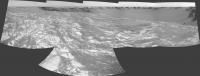
Posted by: jvandriel Feb 17 2007, 01:52 PM
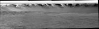
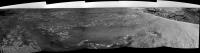
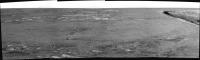
The panoramic view on Sol 1089.
Taken with the L0 Navcam.
jvandriel
|
|
Posted by: Tesheiner Feb 17 2007, 05:22 PM
And this is Opportunity's approximate position as viewed from Cape Desire.
|
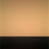
Posted by: Stu Feb 18 2007, 10:42 AM
Where did I put that swear box??!?!?!?!

|
One of the most striking views yet don't you think?
LOVE this planet!!!
Posted by: climber Feb 18 2007, 11:37 AM
Where did I put that swear box??!?!?!?!One of the most striking views yet don't you think?
LOVE this planet!!!
Clink, clink, clink (clinkber
)I agree Stu. There are more : http://qt.exploratorium.edu/mars/opportunity/pancam/2007-02-18/
Can't believe how thin last cape looks like.
Nice Oppy's tracks near The Dock :
|
Lot of dark sand too, with some tiny dark "rays" that seams to feed it from above.
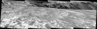
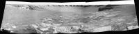
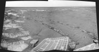
Posted by: jvandriel Feb 19 2007, 08:46 PM
The panoramic view looking back on Sol 1091.
Taken with the L2 Pancam.
jvandriel

|
Posted by: Del Palmer Feb 20 2007, 04:14 PM
It looks like the puzzling driving as seen around Sol 1078 - 1082 may have been due to the live testing of the Field D* autonav software:
http://www.cmu.edu/news/archive/2007/February/feb13_rovers.shtml
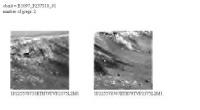
Posted by: jvandriel Feb 20 2007, 08:20 PM
Just added 1 image.
The L0 Navcam view on Sol 1089 and Sol 1092.
jvandriel
|
Posted by: brellis Feb 21 2007, 01:47 AM
Hello all, I'm a n  b to UnmannedSpaceflight. A geological beginner's question about the L2 pancam image from Sol1091: Is the prominent ridge creating the shadow considered to be the point-of-impact when the crater was formed in the first place? To what extent has the surface-level diameter of the crater expanded over eons?
Posted by: CosmicRocker Feb 21 2007, 05:48 AM
Del Palmer: Cool.
Posted by: climber Feb 21 2007, 09:19 AM
Yep, would even be a nice new thread/topic.
Posted by: kenny Feb 21 2007, 09:29 AM
Interesting little rock at the right side of this image. It appears dark in this filter, but light in the other 2.
http://marsrovers.nasa.gov/gallery/all/1/p/1092/1P225125035EFF79QCP2577L2M1.HTML
Posted by: Tesheiner Feb 21 2007, 11:27 AM
Opportunity moved on sol 1094 a few meters to a new location. New pics at the exploratorium.
We can clearly see "Hoy" in this navcam image: http://nasa.exploratorium.edu/mars/opportunity/navcam/2007-02-21/1N225305789EFF79R1P0655L0M1.JPG
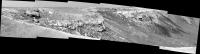
Posted by: Tesheiner Feb 22 2007, 11:15 AM
Roving, roving, roving...
Our little friend moved to almost the other side of the cape few hours ago during sol 1095 and took this 180º navcam mosaic looking north. Bahia Blanca is to the left (west) and cape/bay C3 to the right (east).
|
Posted by: Gray Feb 22 2007, 04:11 PM
Brellis
I'll attempt to provide an answer to your questions. Others may correct me. The initial point of impact of the bolide that formed Victoria crater would have been destroyed in the explosion generated by the impact. The ridge that is visible in the middle background of the sol 1091 panorama has been called "the dock" in this forum and "Guam" by the follks at NASA. As far as I know, there has been no 'official' statement of it's origin.
The scalloped nature of Victoria's perimeter strongly suggests that some erosion has taken place since it's formation. How much erosion has occurred has been the subject of some debate.
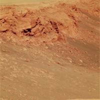
Posted by: Stu Feb 24 2007, 11:54 AM
GORGEOUS views today...
|
Posted by: jvandriel Feb 24 2007, 01:45 PM
The view in the drive direction on Sol 1094.
Taken with the L2 Pancam.
jvandriel
|
Posted by: jvandriel Feb 24 2007, 02:17 PM
Opportunity looking back on Sol 1095.
Taken with the L0 Navcam.
jvandriel
|
Posted by: jvandriel Feb 24 2007, 07:32 PM
Selfportrait of Opportunity on Sol 1096.
Taken with the Front Hazcam.
jvandriel

|
Posted by: mchan Feb 25 2007, 07:54 AM
Nice shot! Thanks for posting it.
Posted by: jvandriel Feb 25 2007, 12:57 PM
The view in the drive direction on Sol 1096.
Taken with the L2 Pancam.
jvandriel
|
Posted by: Stu Feb 26 2007, 01:12 PM
Colourful (and hastily-put-together) Cape Desire...

|
Posted by: MarkL Feb 26 2007, 08:07 PM
Nice local noon shadows and great colour!
Posted by: Tesheiner Feb 26 2007, 09:00 PM
While waiting for some fresh images --today's downlink was a bit sparse-- just say that Opportunity has started its sol 1100.
Posted by: CosmicRocker Feb 27 2007, 06:23 AM
Tesheiner: "...a bit sparse..."  That is such a nicely diplomatic way to say it. There are so many fascinating images waiting in the queue, especially pancams, that I am dying to see. Among those are the Ralls of Madrid and Alava, and...Oh heck, I'll just continue to wait unless someone has a better suggestion. I think praising the 1100th sol is a good reason to celebrate.
It truly reminds me in many ways of the dark material we previously discussed in the Halfpipe formation topic. If that stuff really is some kind of patchy residual soil from an earlier period of erosion, it may not be so surprising to discover another patch of it here.
Posted by: Tesheiner Feb 27 2007, 09:01 AM
Exactly. Here below is a list of images/mosaics on the queue.
01096::p2373::10::16::0::0::16::2::34::pancam_cape_good_hope_longbaseline_L257R2
01096::p2374::10::8::0::0::8::2::18::pancam_dunes_2x1_L257R2
01097::p2375::10::2::0::0::2::1::5::pancam_dunes_2x1_L2
|
01097::p2376::10::4::0::0::4::1::9::pancam_cape_good_hope_longbaseline_L2

|
01097::p2579::17::13::13::0::0::2::28::pancam_madrid_L234567Rall
01097::p2580::17::13::13::0::0::2::28::pancam_alava_L234567Rall
Given that the plan for sol 1099 was almost all untargeted imaging I thought we would finally see those past sols mosaics downlinked at full resolution, not only via the thumbnails, but it wasn't the case. We'll have to wait and, hope I'm wrong, probably it won't be today because sol 1100 imaging plan is drive-related and that takes priority over other data.
PS: For those who haven't seen it, those "pancam_dunes_2x1" mosaics point to the dark dunes at the base of capes D1-D5.
Posted by: jvandriel Feb 27 2007, 07:54 PM
The view looking down on Sol 1094.
Taken with the L2 Pancam.
jvandriel
|
Posted by: CosmicRocker Feb 28 2007, 06:12 AM
I wasn't up to starting a new thread, but this is past Bahia Blanca. The hoped for pancams are not yet down, but the Sol 1100 look back is one of the best ever. Here is my interpretation of this panorama.

|
Posted by: Stu Feb 28 2007, 06:21 AM
STUNNING, Cosmic Rocker, thanks! A great way to start the day... even if I do have to head out to work in 20 mins...
Posted by: Reckless Feb 28 2007, 08:31 AM
Best shot of Victoria from the ground yet Cosmic Rocker.
More capes than a Batman convention.
Roy F
Posted by: Tesheiner Feb 28 2007, 04:47 PM
While looking at the images from sol 1100 I found that they tested what is called VTT (Visual Target Tracking, one of the new software capabilities) during the drive in that sol. There are some references about VTT on the net, including this one on the http://marsrovers.jpl.nasa.gov/mission/status_opportunityAll_2006.html#sol968:
Here below is a navcam image from sol 1098. The rover moved on that direction on sol 1100, passing by a group of peebles seen on the top/right quadrant.
http://marsrovers.jpl.nasa.gov/gallery/all/1/n/1098/1N225663774EFF790EP1963L0M1.JPG (click to enlarge)
That group of rocks was the target, as can be seen on this pancam from sol 1100 named "pancam_VTT_1_L2R2" and taken immediately after starting the driving manouver.
http://marsrovers.jpl.nasa.gov/gallery/all/1/p/1100/1P225836833EFF790GP2892L2M1.JPG
The same group was imaged again at mid-drive (pancam sequence "pancam_VTT_2_L2R2"), then Opportunity left for its destination in the middle of Cape of Good Hope.
http://marsrovers.jpl.nasa.gov/gallery/all/1/p/1100/1P225837906EFF791MP2893L2M1.JPG
It looks like it was "right on the money".
In any case, I hope they don't use this feature on the "lump" or "Hoy". Just in case.

Posted by: Gray Feb 28 2007, 06:38 PM
Ahh, I was wondering why they were focussing on those rocks. (It's the geologist in me). Thanks for the explanation.
Posted by: Tesheiner Mar 1 2007, 02:13 PM
Tosol (1102) imaging plan includes this sequence:
01102::p2379::10::12::0::0::12::2::26::pancam_cape_good_hope_pt1_3x1_L257R2
Part #1? Are we seeing the first part of a 180º color mosaic? I hope so.
Posted by: Tesheiner Mar 2 2007, 10:34 AM
> Part #1? Are we seeing the first part of a 180º color mosaic? I hope so.
Disregard it.
Opportunity is planned to move today (sol 1103). And given the heading (216º) of the post-drive navcam mosaic my take is that the rover will drive towards the lump to take shots of this side of Cabo Corrientes.
Posted by: nprev Mar 2 2007, 01:04 PM
Sol 1102 micro imager pics out of focus... 
http://marsrovers.jpl.nasa.gov/gallery/all/opportunity_m1102.html
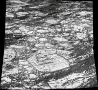
Posted by: jvandriel Mar 2 2007, 07:44 PM
Victoria Crater.
The L0 Navcam view on Sol 1100.
jvandriel
|
Posted by: jvandriel Mar 2 2007, 08:14 PM
Here is my version of the
Sol 1100 R2 Pancam view.
jvandriel

|
Posted by: Pando Mar 3 2007, 12:07 AM
In any case, I hope they don't use this feature on the "lump" or "Hoy". Just in case.
Here's the animation of VTT in action:

Posted by: ElkGroveDan Mar 3 2007, 12:55 AM
Wow. Just wow. Thanks for posting that Pando.
Posted by: Jeff7 Mar 3 2007, 04:57 AM
Wow, that VTT looks quite impressive.
I wonder how much of this new programming will be adapted for use in the MSL, or even upgraded?
Those rovers are so much smarter than when they launched. Target tracking, ability to find dust devils, and reasonably accurate 5-wheel driving capabilities.
Posted by: Tesheiner Mar 3 2007, 07:46 AM
Good animation, Pando!
And the filename too: http://img156.imageshack.us/img156/4994/littlestonehengero3.gif
Posted by: ustrax Mar 3 2007, 05:24 PM
Wowowow!!!
By the way this babies evolve I only expect to see them building a house and having small rovers...
Posted by: Edward Schmitz Mar 4 2007, 04:26 AM
They're both girls!!!
Posted by: CosmicRocker Mar 4 2007, 05:06 AM
Ha!
I'm tempted to make further societal comments, but I'll refrain. 
Posted by: Bobby Mar 4 2007, 05:17 AM
Are The Rovers Male or Female???
Would they give birth to a little Ustrax???
Posted by: Pando Mar 4 2007, 06:26 AM
Only if they go to an abyss together...
Posted by: climber Mar 4 2007, 11:08 AM
Wondering if a big HUG would be enough...
Posted by: jvandriel Mar 4 2007, 02:24 PM
Here is the complete Panoramic view of Victoria Crater.
Taken with the L0 Navcam on Sol 1103.
jvandriel
|
|
Posted by: jvandriel Mar 4 2007, 03:45 PM
Looking back on Sol 1104.
Taken with the L0 Navcam.
jvandriel
|
Posted by: Stu Mar 5 2007, 11:42 PM
Wow, what a mess... can't make much sense out of that view...
|
Posted by: nprev Mar 6 2007, 01:56 AM
Bit of a jumble, all right. Wonder if this is the side of the rim that catches the prevailing winds? Might accelerate erosion locally.
Posted by: Tesheiner Mar 6 2007, 05:32 PM
Just a "bump" to this thread...
Yestersol (1106) was time to take a 12pos (6x2?) B&W mosaic of Cabo Corrientes.
Today is a driving sol (images expected in an hour or two) and tomorrow another mosaic fromof Cabo Corrientes, this time in color.
Posted by: centsworth_II Mar 6 2007, 05:59 PM
"from" should be of?
Posted by: Tesheiner Mar 7 2007, 08:53 AM
Yup. Thanks!
Posted by: Tesheiner Mar 7 2007, 10:21 PM
New update at the MER website.
http://marsrovers.jpl.nasa.gov/mission/status_opportunityAll.html#sol1097
Posted by: glennwsmith Mar 8 2007, 07:12 AM
It's fun to guess about WHEN we're going in -- but (as I sure has already been noted), this will be dictated by WHERE we go in. My money is on Duck Bay, which by coincidence was our arrival point at Vicky. Gradual slope, and steep cliffs on the left to probe on the way down. In other words, Steve is not going to look this gift horse in the mouth, or tempt the fates. A flat out drive back of what -- 20-30 sols? (But! I have not considered sun angle on Oppy if we went in there . . .)
Posted by: Tesheiner Mar 8 2007, 11:51 AM
We are way past Bahia Blanca and Cabo Corrientes so I think it's time to open a new thread.
http://www.unmannedspaceflight.com/index.php?showtopic=4002&hl=
Posted by: jvandriel Mar 8 2007, 10:19 PM
Here is the panoramic view taken on Sol 1096
with the L2 Pancam.
jvandriel
|
Posted by: Ant103 Mar 10 2007, 05:37 PM
I've update the Bahia Blanca view of the Sol 1095 :
http://astrosurf.com/merimages/Images_opportunity-2007.html#Sol1095
Posted by: CosmicRocker Mar 13 2007, 04:48 AM
We received the rest of the sol 1102 look back at the upper lump and Cabo Corrientes in color. It is a nice view. There was a hole in the L2 of the middle frame, which I imperfectly patched. The topographic changes looking back make for a dramatic image. I think the view might even be better from the current location. I haven't checked, but is there another color panorama in this direction in the works?

|
Posted by: Tesheiner Mar 13 2007, 03:28 PM
> ... is there another color panorama in this direction in the works?
These two:
01104::p2381::10::36::0::0::36::2::74::pancam_good_hope_postcard_L456
01108::p2384::10::36::12::0::24::2::74::pancam_cabo_corrientes_longbaseline_9pos
L257R2
Powered by Invision Power Board (http://www.invisionboard.com)
© Invision Power Services (http://www.invisionpower.com)