Printable Version of Topic
Click here to view this topic in its original format
Unmanned Spaceflight.com _ Opportunity _ Oppy's Moving Again!
Posted by: general Jun 30 2005, 08:18 AM
Oppy has finished her investigations at Purgatory Dune, and is about to head... NORTH! (and then east or west 

Latest update from Steve Squyres:
http://athena.cornell.edu/news/mubss/
Posted by: Tman Jun 30 2005, 08:50 AM
Wow, but what's now the result of the study on Purgatory dune?  I hope Steve or the official site comes up with more details later! Are they still in investigations?
Posted by: Tesheiner Jun 30 2005, 12:27 PM
Tman, that is something that I (and most of all) want to know too.
And when Squyres says that they want to go backwards to see which is the best path, by the east or by the west, it means that they shoud HAVE (?) the criteria to decide.
And based on what?
- Dune sizes?
- Slope?
- Termal inertia?
- Color?
Let's do some guessing in the meantime and wait for the next update...
Posted by: Phil Stooke Jun 30 2005, 12:37 PM
OK, I'll do some guessing. My guess is that nothing useful will be learned about the hazard posed by Purgatory - nothing which can be used to avoid another trap. There may be several possibilities, including very fine grain size or a local steep slope - but in the absence of experiments leading to getting stuck or not stuck in lots of other places we will not know for sure what happened. Everywhere else was fine, though, so I expect most driving will continue to be fine, but with various protections built in it might go a bit slower.
Phil
Posted by: general Jun 30 2005, 01:58 PM
I guess Dr Squyres and Co think it's better to be safe than sorry. No more risk taking! After all, they are dealing with a multi-million dollar baby.
If you look at surface of the terrain north of Purgatory Dune (i.e. where Oppy came from - it's as flat as a wet beach) compared to the area south of it (where Oppy was heading - it's more like a choppy sea), it's quite obvious they can't traverse it.
I wonder why it took the operators so long to realize that.
So my idea is that they will go east or west, skirting that 'choppy sea' area until they find an acceptable route to the south.
Posted by: maycm Jun 30 2005, 02:08 PM
Im sure that many things they will have learnt from Purgatory dune will be applied to future rover designs rather than necessarily allowing them to find a different way to tackle this hazard with Oppy.
Posted by: Marcel Jun 30 2005, 02:50 PM
If you look at surface of the terrain north of Purgatory Dune (i.e. where Oppy came from - it's as flat as a wet beach) compared to the area south of it (where Oppy was heading - it's more like a choppy sea), it's quite obvious they can't traverse it.
I wonder why it took the operators so long to realize that.
So my idea is that they will go east or west, skirting that 'choppy sea' area until they find an acceptable route to the south.

Traversability of dunes was fine for hundreds of meters, until oppy got stuck. The morphology of the dunes is absolutely no problem for the mobility system. It's the material that did not support oppy enough to stay on top of it. So, i do not wonder why it took the operators long to realize that. Something happened that was very hard to predict (if not impossible). I agree though on the statement that going back some distance to see whether another route (from the flat part) is better, is the safest next step.
However, i am afraid that there's no other route to Erebus (or Victoria) then through the dunes !
Posted by: djellison Jun 30 2005, 03:16 PM
Well - it's obvious NOW - but wasnt so obvious before
Doug
Posted by: Pando Jul 1 2005, 07:07 AM
We shall find out. We'll be on the road again, in a day or two...
Posted by: dvandorn Jul 1 2005, 02:48 PM
Has anyone heard anything in regards the mini-TES work they did at Purgatory? If anything showed up as characteristic of this particular soft powder, that would help a lot in being able to plan a safe route, regardless of the drift morphology. Just do mini-TES sweeps of various potential routes, and avoid those that traverse through areas with the same characteristics...
-the other Doug
Posted by: Pando Jul 2 2005, 01:41 AM
The miniTES is still flaky, from time to time. But... looks like we're ready to roll now, IDD is stowed so let's get moving!
http://qt.exploratorium.edu/mars/opportunity/forward_hazcam/2005-07-01/1F173462846EFF55WEP1211R0M1.JPG
Posted by: dot.dk Jul 2 2005, 12:29 PM
And we are moving! 

Posted by: abalone Jul 2 2005, 01:19 PM
This shows a nice contrast between new and old wheeltracks. Changes are obvious even though tracks were in opposite direction.
Posted by: Sunspot Jul 2 2005, 01:28 PM
So good to see Opportunity driving again.
How far North do you think they wil go?
Posted by: jvandriel Jul 4 2005, 09:26 AM
A panoramic view of the direction in which Opportunity is moving.
Away from Purgatory Dune.
The old wheeltracks.
jvandriel
|
Posted by: Marcel Jul 4 2005, 11:17 AM
Away from Purgatory Dune.
The old wheeltracks.
jvandriel
Look at the difference in track-depth between left and right ! Depressions are by far safer to traverse.....
Posted by: Sunspot Jul 4 2005, 11:48 AM
Damn ... looks like the exploratorium website is down again - JPL pages are being updated though.
Posted by: jvandriel Jul 4 2005, 05:05 PM
Part of the surrounding of Opportunity. ( rest will follow later ?)
Taken with the L2 Pancam on sol 512.
jvandriel
|
|
Posted by: Bill Harris Jul 5 2005, 12:36 PM
Note that the left tracks are sharper and the right tracks look more wind-eroded. I think that the left tracks are in the wind-shadow of the dune crest. In addition to being a softer surface.
--Bill
Posted by: jvandriel Jul 5 2005, 01:13 PM
Another panoramic view of the surrounding of Opportunity.
Taken with the L2 Pancam on sol 512 after driving a few meters.
Watch the structure of the dunes.
jvandriel
|
|
Posted by: Marcel Jul 5 2005, 01:36 PM
Taken with the L2 Pancam on sol 512 after driving a few meters.
Watch the structure of the dunes.
jvandriel
This is NOT going to be easy to traverse (or go around). It's dunes till the horizon all around.....except to the north

Posted by: Sunspot Jul 5 2005, 02:30 PM
Pictures from Opportunity are being updated at JPL...nothing from Spirit in 6 days though.
Posted by: dilo Jul 5 2005, 11:28 PM
Starting from the two PanCam partial horizon coverages of Sol512 (toward Noth-East and West respectively), I made vertical projection and integrated it with previous one (Sol454, when Oppy was Stuck on the Purgatory dune):
http://img132.imageshack.us/my.php?image=sol454512combo3hf.jpg
Red and blue points show the two rover positions when images were taken; they are about 10.5m apart (scale of 8m/pixel)...
Posted by: Bob Shaw Jul 6 2005, 12:12 AM
Although there's certainly a change between the old tracks and the new, I don't think that we can make judgements about the local erosion environment based on changes to already disturbed material. The fresh exposures elsewhere have actually been amazingly sharp, rather than older tracks being terribly soft (if you see what I mean!).
Posted by: Myran Jul 12 2005, 08:41 PM
Exploratorium update for Opportunity, and for today July 12 even.
These dunes looks like waves.
http://qt.exploratorium.edu/mars/opportunity/navcam/2005-07-12/1N173550454EFF55XKP0603R0M1.JPG
Posted by: mhoward Jul 12 2005, 08:56 PM
That particular image was taken on Sol 511, 10 sols ago. It's already appeared on the JPL raw images page. Still, it's nice to see that Exploratorium is updating again, and it looks like catching up on the backlog as well.
So far the only new images I've seen on Exploratorium have been four Oppy rear hazcam images this morning, and they were also from awhile ago. But I expect we'll be seeing new stuff just any time now.
Posted by: Nix Jul 13 2005, 06:04 AM
Here's a sol 515 view of the dunes. What's a man to do when Spirit's new images haven't yet arrived?
http://www.awalkonmars.com/A2515PCPC8L2synG7E2.jpg
Nico
Posted by: mhoward Jul 13 2005, 06:18 AM
That... is gorgeous.
Posted by: Nix Jul 13 2005, 06:29 AM
Thanks! Made it this morning; the kids got up real early and I needed to stay awake  I couldn't get rid of vignetting though..
Nico
Posted by: Marcel Jul 13 2005, 07:20 AM
I couldn't get rid of vignetting though..Nico
Absolutely great image ! Gives me a real feeling of being there. Also gives me a feeling that is somewhat less comfortable: how on Mars are we going to get trough these fluffies ?
Posted by: Tman Jul 13 2005, 07:31 AM
A higher sky is simply much nicer!
Posted by: SFJCody Jul 13 2005, 09:31 AM
According to the new FDR Oppy has "spent the last two sols driving 15 metres each... on her way south to Erebus crater."
Forward pancams from sol 521:
http://marswatch.astro.cornell.edu/merweb/merweb.pl?choice=obs_summary&obsidtext=B%20%20%20%20%20%20%20%20%20%20%20%20ops521p243405%201&rover=B&test=ops
Posted by: SFJCody Jul 13 2005, 09:38 AM
I think they'll make it through this dunefield without further incident.
Posted by: Nirgal Jul 13 2005, 01:39 PM
Wow ! absolutely awsome color panorama, NIX !
Question: what's the "L2synG7" colorization ? does it mean "green channel
synthesized from averaging red + blue ?
especially like your final color tuning with the warm & pleasant shades of reds
Posted by: aldo12xu Jul 13 2005, 04:36 PM
Awesome, Nico! Another example of the benefits of NASA's open source policy: scientific data transformed into a work of art........Nirgal didn't you render a "colourized" image with the sun low on the horizon as viewed from Larry's Lookout? That one was breathtaking as well.
Posted by: lyford Jul 13 2005, 06:33 PM
WoW Nico -
I wish I had more monitors so I could keep up with the great desktop pictures I get here! 
Thanks
Posted by: Nirgal Jul 13 2005, 08:34 PM
here it is: that hazcam image I've been waiting for two months:
http://qt.exploratorium.edu/mars/opportunity/rear_hazcam/2005-07-12/1R173550291EFF55XKP1314R0M1.JPG
now Oppy finally continues what she has been interrupted from two months ago:
*cruising south* through the sand sea again !
on to erebus ... on to Victoria :-)
Now I hope for two months of careful driving at 10-15 meters a day ...
Posted by: dot.dk Jul 13 2005, 08:58 PM
here it is: that hazcam image I've been waiting for two months:
http://qt.exploratorium.edu/mars/opportunity/rear_hazcam/2005-07-12/1R173550291EFF55XKP1314R0M1.JPG
now Oppy finally continues what she has been interrupted from two months ago:
*cruising south* through the sand sea again !
on to erebus ... on to Victoria :-)
Now I hope for two months of careful driving at 10-15 meters a day ...
I just want to add that that image is 11 days old
Posted by: Nix Jul 13 2005, 09:01 PM
Glad you're enjoying it guys, I spend way too much time on Spirit...but like all of you, I'm waiting for Erebus
Nirgal; I do an average of L3,4 wavelength to color in PS for L2, average L6,7 for L7, take an average and via one or two adjustment layers the final color/appearance. I do the same for R1,2. It's not exactly a consistent process, but then...what is with these .jpegs? 
Nico
Posted by: Bob Shaw Jul 13 2005, 09:15 PM
Nico:
How do you feel about your colours vs the PanCam site's colours? For all that theirs are alleged to be 'true colour', they don't 'feel' right to me! Your version of reality seems, er, realler...
Bob Shaw
Posted by: Nix Jul 13 2005, 10:05 PM
Theirs are the correct colors, the best approximation as to how an astronaut would perceive Mars. You will notice that their images as Daniel Crotty's images show consistency. The methods both use are unquestionable correct. The parameters involved are significant, and scientifically correct.
Especially with .jpegs I can't really produce consistent color.
I won't bother too for the .jpegs. I would like to fully grasp the scientific methods in producing the true color (from RAD's) but now I don't...yet.
I will keep on working with .jpegs for the 'latest' images but the pans should not be regarded as true color, maybe 'near true color' but they will still show too much contrast and oversaturation for some colors with respect to how we would really perceive the scene.
Sorry to dissappoint you there but Mars does seem to look at lot 'softer' and dustier than what we're used to get from the .jpegs..
I like Mars the way it really appears to be but I admit I also appreciate the contrast and saturation you get with the uncalibrated images!
I do already look forward to seeing the upcoming 'Inner Basin' true-color panorama from Cornell!
I just like to think some of the pans I make make nice posters, I'm working on a second version for that sol 510 pan btw, with some 'extra sky' and cropped borders.
Thanks.
Nico
Posted by: stevo Jul 13 2005, 10:58 PM
Delighted to see Oppy moving again, even happier to see her stopping and backing away carefully.
http://qt.exploratorium.edu/mars/opportunity/navcam/2005-07-13/1N173996951EFF5600P1916R0M1.JPG
This image has an interesting small crater in the foreground. I assume that is the dune reforming in front (behind from the wind's perspective).
http://qt.exploratorium.edu/mars/opportunity/pancam/2005-07-13/1P173904618EFF55Z0P2431R2M1.JPG
Steve
Posted by: Nirgal Jul 13 2005, 11:46 PM
Sorry to dissappoint you there but Mars does seem to look at lot 'softer' and dustier than what we're used to get from the .jpegs..
However: if we take into account the remarkable ability of the human vision
to adapt itself to even very slight changes in illumination as well as color hues then I could imagine that for humans living on Mars, once their vision has adapted to the environment, Mars would *appear* to them not nearly as "dull" or "monochromatic" as suggested by the scientifically correct filter composites...
(think of it as a kind of "contrast stretching" automatically processed by the human eye (better: visual cortex) to best utilize the "dynamic range" of the
vision system ... very similar to what JPL does with the contrast enhanced JPEGs)
Perhaps they would distinguish zillion different shades of red just as the Eskimos do with the different kinds of snow
Posted by: Nix Jul 14 2005, 09:09 AM
I suppose that maybe if we colonize Mars in the future that there could be some evolution of our species as an adaptation to the new environment/amount of Sunlight, etc... but I don't know about any impact that could have on our perception..
I don't believe btw that astronauts will offer more credibility on the appearance/impression you'd get from being there. I think even better instrumentation and analysis in conjunction with real-time orbiter-data of the lander-location will provide a perfect model before that time. The skeptics on color will eventually say that the astronaut is obviously in on the complot, he can't judge it fairly because of the UV-protective coating on his window or the camera he was using was designed to operate on Earth ...or something like that.
Don't you think? 
Nico
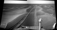
Posted by: djellison Jul 14 2005, 11:56 AM

http://www.unmannedspaceflight.com/doug_images/o_indep.jpg 270kb
Posted by: Nix Jul 14 2005, 12:20 PM
I like that! Terrific look at the manoeuvers and the potential risk.
Nico
Posted by: Bill Harris Jul 14 2005, 12:34 PM
Standing ovation.
Looks good. The surface appears to be firm and stable. I see a couple of "plowed" spots on the tracks, but that seems to be a side effect of dragging the non-steering wheel through turns.
--Bill
Posted by: Tman Jul 14 2005, 12:53 PM
And it's hard to believe
http://www.greuti.ch/oppy/direction_south_517-22.gif
Good girl!
I wonder Oppy drives forward and not backward?!
Posted by: djellison Jul 14 2005, 01:33 PM
they alternate between backwards and forwards every couple of sols
Doug
Posted by: Burmese Jul 14 2005, 01:37 PM
With Oppy headed south again it would be nice to see another Squyers update. Also, I wonder if they are going thru some transition period with the support personnel and that is part of the reason for the erratic updates of late?
Posted by: Bill Harris Jul 14 2005, 01:49 PM
And also Oppy has the bad steering motor on a front wheel and I'd imagine that she steers better with the good wheels in the front.
The Girls are getting old and creaky; I can relate to that.

--Bill
Posted by: maycm Jul 14 2005, 03:02 PM
Is Oppy actually driving South yet?
Difficult to get bearings and orientate from the picture. Is that Purgatory is off on the left?
If so then Oppy drove 'North' as she goes off to the right, then back again and drove East for a bit and is the process of making another turn.
Posted by: odave Jul 14 2005, 03:33 PM
The drive sequence through Sol 517 is on the http://marsrovers.jpl.nasa.gov/mission/status.html#opportunity. in summary:
Sol 516: An 11-meter (36-foot) drive to the east crossed two small ripples and positioned the rover to enter the trough leading south. [...]
Sol 517 (July 8, 2005): [...] this drive, designed to take Opportunity 4 meters (13 feet) east to the north end of the trough, then 11 meters (36 feet) south through the trough.
Looking ahead:
Opportunity will continue the drive south, more slowly than before to ensure a safe path.
Looks like the MER people are filtering back from vacation
Posted by: mhoward Jul 15 2005, 02:34 AM
I love this image and I don't think anyone's posted it yet, so: http://www.flickr.com/photos/36868531@N00/26029955/
Maybe everybody's seen it on the fancy new Pancam page already.
P.S. It's so nice that Exploratorium is finally updating again...
Posted by: CosmicRocker Jul 15 2005, 05:47 AM
Thanks, Doug. That's the path I was picturing from image browsing, and that was certainly a mosaic worthy of posting. I am still getting the impression that this area where Opportunity was stopped in it's southward progress is a higher bank of dunes.
I can't help but speculate. I'm not sure how best to put it into words, but it looks to me as if Opportunity had climbed onto a longer wavelength, higher amplitude dune, upon which are the smaller dunes. The climb seems to have started just prior to sol 439.
Perhaps these longer wavelength dune trains are fluffier than the intervening material because they collect the material that is being actively transported by the wind.
Then again, we had been expecting to see Opportunity climb in elevation as it approached the Etched Terrain and Victoria. Maybe this is just a transition zone where particulates are collecting at the edge of elevated rock layers that are exposed to the south. I pray we can make it a few hundred meters/yards to the south, since this appears to be a transition into something new.
This is true exploration. Is there anyone who's heart is not pounding?
Posted by: sapodilla Jul 15 2005, 07:25 AM
Look at the shadow.
Posted by: Nirgal Jul 15 2005, 12:18 PM
this is sooo true
this (together with JPL's internet "live" publishing) is the most "explorative feeling" space mission ever, including the moon landings and Voyager ...
Nirgal
P.S.:
And the best of all is yet to come: The Great Victoria Crater...
I bet: if we eventually reach it, then we will get the most spectacular images ever
from another planet ...
Posted by: Marcel Jul 15 2005, 01:09 PM
this (together with JPL's internet "live" publishing) is the most "explorative feeling" space mission ever, including the moon landings and Voyager ...
Nirgal
P.S.:
And the best of all is yet to come: The Great Victoria Crater...
I bet: if we eventually reach it, then we will get the most spectacular images ever
from another planet ...
And YOU are going to colour them for us
Can't wait.
Any idea how long we'll have to wait until she gets there ? How much distance to the rim from here ?
Posted by: djellison Jul 15 2005, 02:18 PM
Still a long way to go
Several km's - 3 perhaps
Doug
Posted by: Marcel Jul 15 2005, 03:01 PM
At 15 meters a day that would mean....arrival around februari 2006
Posted by: Nirgal Jul 15 2005, 03:50 PM
-> back to 40+ meters/day when better terrain is reached
Victoria Crater by Christmas !
Posted by: Nirgal Jul 15 2005, 04:10 PM
Can't wait.
Yeah, but for the pancam multi-filter-images there will be nothing better than
the composites from Doug, Horton, Nico, Daniel (slinted) ...
(expect them in the forum way before JPL will be publishing their "Christmas"-Victoria-Panorama
In the mean time I'll do my best for the Navcam & Hazcam coloring....
Together, this forum really makes the best out of the all the raw data brought to us by JPL ...
Posted by: Myran Jul 15 2005, 07:03 PM
And the really interesting area south of Victoria even far later, but I might be hoping for too much there.
Posted by: alan Jul 15 2005, 07:07 PM
A look back at the last few sols progress
http://qt.exploratorium.edu/mars/opportunity/navcam/2005-07-15/1N174611782EFF56F7P1601R0M1.JPG
Posted by: RNeuhaus Jul 15 2005, 08:00 PM
http://qt.exploratorium.edu/mars/opportunity/navcam/2005-07-15/1N174611782EFF56F7P1601R0M1.JPG
It looks like that the rover's driver is driving very well. Before crossing any ripple, always climbs as perpendicular as possible to ripple in order to facility a better climbing up.
Rodolfo
Posted by: gregp1962 Jul 15 2005, 08:33 PM
A look back at the last few sols progress
http://qt.exploratorium.edu/mars/opportuni...F7P1601R0M1.JPG
How far past Purgatory Dune is that picture?
Posted by: general Jul 16 2005, 07:17 AM
New update from Steve Squyres:
"We're making some real progress at Meridiani. Our little jog to the north revealed a good southward route on the eastern side of Purgatory Dune, so that's what we went for. Since then we've been making steady southward progress, and as of now we're almost 90 meters south of Purgatory."
http://athena.cornell.edu/news/mubss/
Posted by: TheChemist Jul 16 2005, 11:18 AM
I think Purgatory is to the top left of the image. Steve said, we are about 90m south from there.

|
Posted by: jvandriel Jul 16 2005, 11:56 AM
A panoramic view of Purgatory Dune and the way around it.
Taken with the L Navcam on sol 522.
jvandriel

|
Posted by: ElkGroveDan Jul 16 2005, 02:15 PM
as of now we're almost 90 meters south of Purgatory."
http://athena.cornell.edu/news/mubss/
I think it's time to break out the overhead maps again.
Posted by: SFJCody Jul 18 2005, 10:15 AM
Post-drive L7/R1 (sol 526)
http://marswatch.astro.cornell.edu/merweb/merweb.pl?choice=obs_summary&obsidtext=B%20%20%20%20%20%20%20%20%20%20%20%20ops526p243805%201&rover=B&test=ops
Posted by: Sunspot Jul 18 2005, 10:27 AM
haz cam subframes of the right front wheel on sol 525:
http://marsrovers.jpl.nasa.gov/gallery/all/opportunity_f525.html
....hope nothing else has gone wrong with it...
Posted by: djellison Jul 18 2005, 11:19 AM
Lots more outcropping appearing
http://marswatch.astro.cornell.edu/oss/merb/ops/ops/surface/tactical/sol/526/opgs/edr/pcam/jpeg/1P174883903EFF5700P2438L2M1_stamp.jpg
And..is that a hint of Victoria?
http://marsrovers.jpl.nasa.gov/gallery/all/1/n/526/1N174883608EFF5700P0693L0M1.JPG
Doug
Posted by: Bob Shaw Jul 18 2005, 11:52 AM
Some interesting lumps, too...
Posted by: RedSky Jul 18 2005, 11:56 AM
http://marswatch.astro.cornell.edu/oss/merb/ops/ops/surface/tactical/sol/526/opgs/edr/pcam/jpeg/1P174883903EFF5700P2438L2M1_stamp.jpg
On the upper left of this image... is that outcrop or light-topped dunes?
http://marsrovers.jpl.nasa.gov/gallery/all/1/p/526/1P174883903EFF5700P2438L2M1.JPG
If its outcrop... might it be the onramp to the Erebus highway? Oppy will have to "change lanes" quite a few times to get over to it.
Posted by: Vladimorka Jul 18 2005, 12:14 PM
http://marsrovers.jpl.nasa.gov/gallery/all/1/n/526/1N174883608EFF5700P0693L0M1.JPG
Doug
More interesting to me is the small filled crater ahead of oppy :-)
Posted by: Bill Harris Jul 18 2005, 12:18 PM
Yes!
Did we ever look closely at those dark, angular-seeming rocks that we've been seeing "recently"?
--Bill
Posted by: Phil Stooke Jul 18 2005, 01:03 PM
I don't think there is any hint of Victoria yet. I think we are still seeing only local relief on a close horizon. At the distance of Victoria, haze would make relief look brighter against a dark nearby horizon, so I think we have yet to see really distant terrain here. It seems we are creeping across a very broad shallow rise, with a horizon that never seems to change but is actually a different row of little mounds each time. I think we will suddenly get to the top or edge and look out on a very different vista.
Phil
Posted by: Nirgal Jul 18 2005, 03:36 PM
Land Ho !
http://qt.exploratorium.edu/mars/opportunity/pancam/2005-07-18/1P174883903EFF5700P2438L2M1.JPG
http://qt.exploratorium.edu/mars/opportunity/pancam/2005-07-18/1P174884154EFF5700P2438L2M1.JPG
http://qt.exploratorium.edu/mars/opportunity/pancam/2005-07-18/1P174883903EFF5700P2438L2M1.JPG
Posted by: djellison Jul 18 2005, 04:16 PM
Not to put too much of an american-teen twist on it...
but that SOooooooo looks like white horses on a choppy sea
Doug
Posted by: john_s Jul 18 2005, 04:44 PM
Land Ho !http://qt.exploratorium.edu/mars/opportunity/pancam/2005-07-18/1P174883903EFF5700P2438L2M1.JPG
http://qt.exploratorium.edu/mars/opportunity/pancam/2005-07-18/1P174884154EFF5700P2438L2M1.JPG
http://qt.exploratorium.edu/mars/opportunity/pancam/2005-07-18/1P174883903EFF5700P2438L2M1.JPG
That's funny- I saw those same images and the exact same phrase, "Land Ho!", came to my mind- I was going to post a message with that title but Nirgal beat me to it. It does feel like we are finally approaching dry land...
Posted by: mhoward Jul 19 2005, 05:18 AM
http://www.flickr.com/photo_zoom.gne?id=27026505&context=photostream&size=o from Sol 526, including the possible mini-crater.
Posted by: CosmicRocker Jul 19 2005, 05:36 AM
Aahhrrg, ye maties. There be rocks ahead!
Drop the Mainsail and prepare to drop anchor...
Sorry, couldn't help myself... Sometimes I feel as if we are pirates, stealing data from the universe. I'm encouaged to notice that the dunes seem less formidable here, as Steve previously pointed out. Hopefully the worst storms are behind us.
 ...
...
Posted by: Nirgal Jul 21 2005, 08:42 AM
just when it started getting fun again ...
the driving-party seems to have stopped again 
From the latest exploratorium images, Oppy hasn't moved at all for
the past two days:
http://qt.exploratorium.edu/mars/opportunity/rear_hazcam/2005-07-18/1R174883427EFF5700P1311R0M1.JPG
http://qt.exploratorium.edu/mars/opportunity/rear_hazcam/2005-07-18/1R174883427EFF5700P1311R0M1.JPG
Hope everything's alright ...
Posted by: Vladimorka Jul 21 2005, 09:54 AM
Moved:
http://qt.exploratorium.edu/mars/opportunity/rear_hazcam/2005-07-20/1R175056599EFF5702P1311R0M1.JPG
just a few centimeters, but it surely moved :-)
Posted by: Sunspot Jul 21 2005, 10:12 AM
I think perhaps they may be re-aligning the rover for it's next drive?
Posted by: Burmese Jul 21 2005, 12:59 PM
They were probably spending extra time looking at the patches of rock poking thru and trying to make that 'SE to the highway Vs S direct to Erebus" decision.
Watches Steve flip a coin...
Posted by: RNeuhaus Jul 21 2005, 01:17 PM
Still an endless desert...following safely thru the Blueberries valleys.
Rodolfo
Posted by: Nirgal Jul 21 2005, 02:33 PM
Watches Steve flip a coin...
don't think so: after two months stuck in purgatory and the limited
remaining lifetime for the long way ahead, I would be surprised if we simply wasted two or three
sols not being used to (at least try to) continue the drive to Erebus where the science waits.
Instead, I think the stopping could be related to "restricted sols" or similar technical reasons ...
BTW.:
new Jul-21 images up at explor still showing no progress ...
Posted by: Nirgal Jul 21 2005, 02:41 PM
anopther possibility for the halt would be the study of possible changes in surface composition in the vicinity of Erebus which would make sense because it could help improving the new hazard-avoidance policies in the driving software ...
Posted by: Sunspot Jul 21 2005, 02:51 PM
I think you can just about make out Endurance Crater in this image:
http://qt.exploratorium.edu/mars/opportunity/navcam/2005-07-21/1N175144546EFF5702P1607R0M1.JPG
A couple of pixels high.
Posted by: RNeuhaus Jul 21 2005, 03:08 PM
http://qt.exploratorium.edu/mars/opportunity/navcam/2005-07-21/1N175144546EFF5702P1607R0M1.JPG
A couple of pixels high.
I am impressed of the uniformity of sand waves (crest). It is not so normal here in Earth.
Rodolfo
Posted by: jvandriel Jul 21 2005, 05:34 PM
Opportunity looking ahead.
View taken with Pancam L2 on Sol 528.
jvandriel
|
|
Posted by: jvandriel Jul 21 2005, 05:47 PM
Panoramic view of a windblown crater.
Taken with the L2 Pancam on Sol 528.
jvandriel

|
Posted by: DEChengst Jul 21 2005, 06:25 PM
You can also clearly see the new driving technique. They stay between the dunes and do not cross them as they used to do. They follow the dune and if it runs out they "change lanes" as Steve Squyres puts it.
Posted by: Nirgal Jul 21 2005, 06:50 PM
View taken with Pancam L2 on Sol 528.
jvandriel
Like your panorama, jvandriel: it once again dramatically shows the "dynamic" surface of this vast "frozen sea of sand" !
wish we'll soon find our feet on firm ground again
Posted by: CosmicRocker Jul 22 2005, 05:16 AM
As they say, "Land Ho!"
Posted by: mhoward Jul 22 2005, 05:25 AM
Even Steve Squyres is saying it! I guess it must just be that obvious.
Posted by: Marcel Jul 22 2005, 07:33 AM
I guess Steve's giving us a hint, to let us know he's been here...
Posted by: Nirgal Jul 22 2005, 07:57 AM
I particularly like the wollowing two of Steve's statements:
Taking together that means: The dream of reaching the
Great Victoria Crater is getting more and more realistic
.... Hmmm ... with time my growing Obsession with Victoria is starting to get as serious as Ustrax's with Ultreya
Posted by: Sunspot Jul 22 2005, 08:48 AM
Changeing lanes:
http://qt.exploratorium.edu/mars/opportunity/rear_hazcam/2005-07-21/1R175239429EFF57BHP1311R0M1.JPG
Posted by: edstrick Jul 22 2005, 09:13 AM
While the view of Victoris from the rim will be fantastic, and there is real science to do if we can get down into the rocks just below the rim where there's "ramps" into the crater (one may be on the northwest), I think the entire interior of Victoria below the upper rim is a sand trap like the deeper interior of Endurance. Be nice if we could, but don't expect to go there, unless it's a fatal booboo.
What I'm most interested in at the Erebus/Victoria range is exploring the XY two dimensional structure of what I assume are evaporite rocks exposed in the etched terrain. We explored the Z dimension in Eagle and the walls of Endurance, but we need to see it layed out in front of us, stripped of -- it looks like up to 2/3rds -- of the overlying sand sheet we're treking across now. We will see small craters in the rock's surface, not in sand with ejected rock, see the erosional degradation cycle of craters, see fissures and fracture patterns in the rock...... and most importantly, have a real chance of seeing shoreline processes and sub-aqueas sedimentary process laid out in their horizontal geometry.
And if little-green-men walked the shores of this salty acid sea, we'll find their footprints, complete with acid-raised blister marks! <grin>
Posted by: Marcel Jul 22 2005, 09:24 AM
I hope for the same. There's one "but": we don't *know* if it is rock. It might be a lighter toned, eroded remnant (soil) material of what once was an outcrop of a crater rim....
We'll soon find out, because oppy's driving like crazy again in lines as straight as a ruler. I wonder how they manage to do this with a 7 degrees off axis front wheel
Posted by: edstrick Jul 22 2005, 09:37 AM
There's one "but": we don't *know* if it is rock. It might be a lighter toned, eroded remnant (soil) material of what once was an outcrop of a crater rim....
AMEN. I'd be very surprised if it was... The highest rez images show all sorts of textures that look like a stripped, eroded bedrock surface, with little spots I'm pretty sure are more and less degraded small impact craters and other fascinating textures at the limit of visibility...
BUT.. it could be... or... "None of the Above"... fossil mats of martian algae?.. I doubt it.. but etched terrain might be a place to look.
Posted by: general Jul 22 2005, 09:47 AM
I hope I'm wrong, but the 'etched terrain' looks like an area full of very rough rock, not unlike 'karst'.
Also, we should not underestimate the distance between Erebus crater and Victoria crater: over a mile long. And if Oppy reaches Victoria, climbing the crater's rim will be quite a challenge, too.
http://i12.photobucket.com/albums/a250/Moolie/etched_terrain.jpg
Posted by: Sunspot Jul 22 2005, 09:56 AM
Where abouts is Opportunity on that map now that they've started driving again?
Posted by: general Jul 22 2005, 10:01 AM
The red dot in the upper right hand corner
Posted by: Sunspot Jul 22 2005, 10:04 AM
hmmm...are you sure? I would have thought they would have moved further south than that by now.
Posted by: edstrick Jul 22 2005, 10:23 AM
"I hope I'm wrong, but the 'etched terrain' looks like an area full of very rough rock, not unlike 'karst'. "
It does look rough, but remember the images we look at have usually been sharpened and very strongly contrast stretched. I think a lot of the roughness is albedo patterning of the wind-and-sand-etched surface, with all the little dips and hollows with a few inches of sand and saltation-rolled blueberries concentrated in them.
Posted by: Nirgal Jul 22 2005, 10:31 AM
one of the reasons I'm so obsessed with Victoria Crater is the fact that
this will be the view of a special kind of alien landscape as has never ever been seen bevor ( except the "foretaste" of Endurance)
We have seen other great views, for example from the Columbia Hills across the Gusev Plains: Breathaking ! but at the same time similar to other views we're familiar with e.g. from the Arizona desert here on earth... not the same as on earth of course, but somewhat similar.
Whereas Victoria as a "Rugged kilometer-sized giant crater filled with a bizarre sea of sand dunes" represents a new kind of landscape that is unique to the planet Mars !
We havn't seen something similar on Earth nor on the Moon or any other planet yet.
Posted by: general Jul 22 2005, 10:46 AM
No, not sure... It's only a general indication of where the rover is/was. She might be much further south already.
Posted by: Bill Harris Jul 22 2005, 12:33 PM
Good comments, Ed (et al).
"We'll see what we see when we see it." I hope that you are correct, but in addition to albedo features I see shadows. I hope that the Etched Terrain surface will be passable, but it might be much like the "ghostly ring" craters like Fram and Vostok and Voyager. This is, after all, a "Terra Incognito". Perhaps landing in Purgatory was a blessing, it alerted us to dangers ahead and now we are proceeding with caution and not highballing at breakneck speed (for a Rover, that is).
Once we get to the Etched Terrain proper, there will be plenty of "scratch and sniff" opportunities, in a manner of thinking. Examining the surface of the evaporite unit will be good geology.
--Bill
Posted by: sapodilla Jul 22 2005, 12:46 PM
The contrast between light and dark make it to look like the dark areas are shadows but I think that the light areas in is exposed bedrock and the dark areas soil so it should be very easy for Oppy to drive.
Posted by: Burmese Jul 22 2005, 01:05 PM
That horizon still looks fairly rugged. My guess is that the terrain between Erebus and Victoria will be somewhere in between 'just drivable' and a maze. Some stuff Opportunity will be able to drive over, elsewhere the rover will need to make painfully circutious routes to make forward progress.
Posted by: Phil Stooke Jul 22 2005, 02:14 PM
The red dot is about where they got stuck. Opportunity is half way to Erebus from there now.
Phil
Posted by: jvandriel Jul 22 2005, 07:25 PM
A 360 degree panoramic view taken by Opportunity with the L Navcam on Sol 527-528.
jvandriel
|
|
Posted by: Phil Stooke Jul 22 2005, 08:07 PM
...and the previous post (thanks!) reprojected to a polar view.
Phil

|
Posted by: RNeuhaus Jul 22 2005, 08:33 PM
Phil
|
|
Phil, Very nice picture. What tool did you employ to strech it out from the top?
Rodolfo
Posted by: Sunspot Jul 22 2005, 10:29 PM
Anyone else think the dunes look as though they are a little smaller now?
http://marsrovers.jpl.nasa.gov/gallery/all/1/f/530/1F175239393EFF57BHP1214L0M1.JPG
Although, it's sometimes hard to tell with hazcam images as they distort objects.
Posted by: Phil Stooke Jul 23 2005, 12:59 AM
Rodolpho, I did this in Photoshop. The vertical scale change is done by stretching the whole image vertically and then shrinking the foregound in several steps (bottom 80% shrunk 10%, then bottom 70% by 10% (of original height) and so on. I've been told another method with a mask layer could do this but I have never figured it out. This is quick and effective but not accurate, of course, it just gives an impression. Dilo's work with Povray is more precise.
Phil
Posted by: Bill Harris Jul 23 2005, 04:35 AM
Sunspot, I have been thinking the same thing: the dunes _do_ look more civilized as we head southward.
--Bill
Posted by: CosmicRocker Jul 23 2005, 05:05 AM
http://marsrovers.jpl.nasa.gov/gallery/all/1/f/530/1F175239393EFF57BHP1214L0M1.JPG
Although, it's sometimes hard to tell with hazcam images as they distort objects.
I think the overall trend in height has certainly been downward since Opportunity has left Purgatory, although it has been variable. Steve Squyres has similarly speculated in a recent update. Each of the camera types do see it differently, and the dunes appear differently from different directions, but I think the trend is real.
Keeping with the nautical theme, let's hope we have left the storms behind us.
Posted by: dilo Jul 24 2005, 09:07 PM
Not sure if anyone already posted and, for shure, aren't very last images but...

|
The drive sequence between the dunes is amazing! Great drivers in JPL, maybe Alonso should worry about!
Posted by: dilo Jul 24 2005, 09:16 PM
And in the next Sol, they made a "chicane" over a small dune (veery dangerous!)

|
Posted by: Nirgal Jul 24 2005, 10:21 PM
|
|
phantastic animations !
Posted by: RNeuhaus Jul 24 2005, 10:44 PM
http://marsrovers.jpl.nasa.gov/gallery/all/1/f/530/1F175239393EFF57BHP1214L0M1.JPG
Although, it's sometimes hard to tell with hazcam images as they distort objects.
Yes, indeed that the front and rear hazcam disorts the images. They are designed for a close up view.
On the other hand, floor is incredibly smooth and compact. Almost no stones except to a small metorite close to heatshield.
Rodolfo
Posted by: CosmicRocker Jul 25 2005, 04:24 AM
|
|
The drive sequence between the dunes is amazing! Great drivers in JPL, maybe Alonso should worry about!
Yes, dilo. It makes a most excellent movie. I also noticed that the downsampled images showed up on the marsrovers site today. There are about 140 images from sol 520 through 523 in the whole thing, and it is quite amazing to watch.
I spent some time trying to make the whole sequence fit into a smaller file for posting, but I gave it up. I have no software that can batch-convert those RGBs into a grey scale, which would have helped reduce the size a lot.
For the MMB users out there, it is command sequence F0006. Just set the time interval between frames to your liking, pick your favorite navcam eye, and launch the slide show. I particularly enjoyed watching an anaglyph version, though you can get a pretty good sense of the topography Opportunity has been traversing from just one of the eyes.
Posted by: Jeff7 Jul 26 2005, 01:01 AM
I spent some time trying to make the whole sequence fit into a smaller file for posting, but I gave it up. I have no software that can batch-convert those RGBs into a grey scale, which would have helped reduce the size a lot.
For the MMB users out there, it is command sequence F0006. Just set the time interval between frames to your liking, pick your favorite navcam eye, and launch the slide show. I particularly enjoyed watching an anaglyph version, though you can get a pretty good sense of the topography Opportunity has been traversing from just one of the eyes.
http://www.irfanview.com/ does have a batch convert option. Its Advanced options include a 256 color (8bpp) option, but nothing that explicitly says "grayscale." Give it a shot, maybe it'll work. If not, maybe it can be suggested to the author.
Posted by: Bill Harris Jul 26 2005, 02:10 AM
Irfanview is an excellent all-around image editor. An 8-bit/pixel image is indeed grayscale. A 24-bit (true color) image is is nothing more than three (RGB) 8-bit datasets combined.
--Bill
Posted by: tacitus Jul 26 2005, 03:30 AM
|
|
The drive sequence between the dunes is amazing! Great drivers in JPL, maybe Alonso should worry about!
Nice animation. Looks like they risked going over a very small dune (pretty safe really) rather than continue into some deeper looking sand. Wise move, I'd say.
Posted by: CosmicRocker Jul 26 2005, 04:41 AM
Thanks Jeff7, and Bill. It sure looks like it should work, but I tried it and it didn't work for me.
Posted by: mike Jul 26 2005, 05:14 PM
Technically, an 8-bit image can be in color - PNGs use 8 bits per pixel, because each pixel is one of 256 colors in a palette that is unique to each PNG (8 bits can store an integer anywhere in the range of 0-255). Each color in the palette is 24-bit, mind you, but you can only select 256 of them per file..
PNGs have built-in non-lossy compression, so an 8-bit PNG might still look decent while not being too large. By the way, PNGs are similar to GIFs (PNGs are patent-free, is all), so if PNG isn't supported GIF might work.
Posted by: clt510 Jul 26 2005, 05:56 PM
These days http://www.kuro5hin.org/story/2003/6/19/35919/4079
Unisys's patent ran out in June, 2003.
Posted by: mike Jul 26 2005, 07:06 PM
That's good to hear. I guess GIF is dead by now anyway.. though apparently the patent also applied to just about every file compression format known to man. Thanks for letting me know.
Posted by: Nix Jul 27 2005, 06:03 AM
On a side note, Opportunity's deck looks quite dusty.
http://marswatch.astro.cornell.edu/pancam_instrument/images/Sol501B_P2555_1_True_RAD.jpg
I hope the latest cleaning event was one of several to come.
Nico
Posted by: djellison Jul 27 2005, 06:47 AM
Well - a 500 -> 650w hike is substantial
Posted by: MERHope Jul 27 2005, 08:53 AM
The big difference though is in color depth. PNG supports arbitrary bit depths, of course. So you can have a 24-bit truecolor PNG. ...but even at 8-bit it's still better than GIF. PNG supports a 24-bit palette -- GIF only supports an 18-bit palette (262,144 colors). GIF's limitations were basically built around the original IBM VGA card, so the palette limitation is there too.
Posted by: edstrick Jul 27 2005, 09:10 AM
Gifs are reasonably okay for uncompressed 8-bit black and white, though I usually use compressed TIF's so there's no lookup table at all.
Gifs are still perfectly good for simple unshaded graphicy things like icons or images of text. A gif of a high rez pen-and-ink line drawning can be saved as a 4-bit image and look perfect. Saturated black ink on white background, and partial-pixels on the edges of lines having graytones.
Gifs are also nice as small monochrome animations. If you want big videos, go lossy compression anyway.
Posted by: mike Jul 27 2005, 05:15 PM
The big difference though is in color depth. PNG supports arbitrary bit depths, of course. So you can have a 24-bit truecolor PNG. ...but even at 8-bit it's still better than GIF. PNG supports a 24-bit palette -- GIF only supports an 18-bit palette (262,144 colors). GIF's limitations were basically built around the original IBM VGA card, so the palette limitation is there too.
Wow, you're right, VGA did only support 6 bits per channel.. I always thought it used all 8. That explains why I didn't get the range I expected when drawing in certain graphics modes, heh. I stand corrected. So yeah, use 8 bit PNG.
Posted by: maycm Jul 27 2005, 06:45 PM
Just a polite suggestion guys but this discussion should be in the Imagery & Tech Issues forum.
Posted by: Sunspot Jul 28 2005, 01:03 PM
SOL 536 drive:
http://marsrovers.jpl.nasa.gov/gallery/all/1/r/536/1R175770709EFF57KRP1311L0M1.HTML
Posted by: Nirgal Jul 31 2005, 08:47 PM
very good to see her moving slowly but steadily and surely day by day ...
even over the weekend (thanks again to the JPL rover team for the great work and commitment !)
And the best of all: Steve must be a Victoria fan too !!
I was quite a bit reliefed when I read the following passage in Steve Squyres' latest mission update:
this can only mean that Victoria is still considered a target at all (something I must admit I was no longer so sure of after the purgatory event)
ok it will not be easy to reach it, but at least it seems that after Erebus, chances are good that they will actually try the go for the Great Victoria Crater
Nirgal
****=> Opportunity final destination: Victoria Crater by Christmas 2005 !
Posted by: dilo Jul 31 2005, 11:25 PM
wrong thread...

|

|
Posted by: dilo Jul 31 2005, 11:48 PM
Did someone noticed this crater near horizon?

|
I do not know direction, but could be the orange-highlighted in this MOC image...

|
Posted by: alan Aug 1 2005, 02:23 AM
Thats off to the east. I remember seeing it in the panarama they made when Oppy was stuck.
Posted by: dot.dk Aug 1 2005, 02:38 AM
That's because the Erebus map is turned upside down. It took a moment before I realised that too
Posted by: Decepticon Aug 1 2005, 02:43 AM
I hope we visit R2 than D2 first.
Posted by: Phil Stooke Aug 1 2005, 03:46 AM
yes, Dilo, I think you are probably right about that crater. And look at the horizon beyond it... a view of much more distant terrain beyond a nearby horizon.
Phil
Posted by: Burmese Aug 2 2005, 01:22 PM
So much for staying in the trenches:
http://marsrovers.jpl.nasa.gov/gallery/all/1/n/540/1N176132024EFF57LRP1605L0M1.JPG
Oppie hopped three dune ridges in one drive, and is running right next to the 'Erubus Highway'
http://marsrovers.jpl.nasa.gov/gallery/all/1/n/540/1N176132376EFF57LRP1605L0M1.JPG
Posted by: Jeff7 Aug 2 2005, 09:44 PM
Quick aside here - check out Irfanview again. The PNGOut Plugin with Irfanview has a Gray option for the output type. You might
want to check out the http://advsys.net/ken/util/pngout.htm first to try to lighten the compression a bit,
because PNGOut does a REALLY thorough job of compressing files, using multiple passes.
Edit: Well duh, now I see it. Under Advanced Options, on the right side is a checkbox: Convert to Grayscale. None of the messing with the Change Color Depth boxes...geez.
Might that do the trick?
Though using PNG for the rover pics would be awesome - I don't know what it'd do the the filesize, but PNG is lossless. I wonder why NASA doesn't use it? Much smaller files than TIF's.
Posted by: mhoward Aug 3 2005, 12:23 AM
Experimenting here... Click on the image for the large version.
http://www.flickr.com/photo_zoom.gne?id=30749920&size=o
Posted by: Airbag Aug 3 2005, 01:18 AM
Looks like you (well, your MMB!) is blending together navcam and pancam images? Very impressive; I noticed you did something similar with false-colour rock close-ups set against B&W navcam images.
How are you doing this - it almost seems like you have access to the camera's pointing vectors - but those have not been released yet for these recent images, surely? I know from experience that panorama generation is not an easy thing to do.
I'm very impressed by these hybrid images!
Airbag
Posted by: mike Aug 3 2005, 02:23 AM
The TIFF format has been around for a long time, whereas PNG is a newcomer.. TIFF also allows you to specify just about everything anyone could ever possibly care about image-wise, whereas PNG deliberately concentrates on the 'basic' image data. Look at the specs for TIFF sometime, you'll see what I mean.
Posted by: mhoward Aug 3 2005, 02:34 AM
Airbag: It's a http://homepage.mac.com/michaelhoward/MidnightMarsBrowser/metadata.html. Shhhh! (Scroll down to the bottom)
But in short, yes, it's a combination of images, and no, I don't have access to the pointing information, I have to deduce it as more-or-less documented in the super-secret link. More detail than that I'd probably reserve for the MMB-specific thread.
Posted by: Jeff7 Aug 3 2005, 04:27 AM
But does NASA actually use any of that extra stuff? All I can find extra in one image I downloaded from their catalog is the kind of compression used (LZW) and what I assume is the program used to compress the file - VICAR Program VTIFF.
I suppose extra info embedded in a file could be useful though.
Posted by: mike Aug 3 2005, 09:57 PM
I suppose extra info embedded in a file could be useful though.
From what I recall, TIFF was created long long ago, when there was wide disparity between how images were represented in various mainframes (and maybe even minicomputers!), and there simply was no unified graphics file format, so they threw everything they could think of into the spec so that nobody would be left out. It's a pretty crazy format - it seemed overly complex when I looked at it way back when, but maybe it would make more sense to me now. Regardless, it's been around so long that it's still 'the' image format to use when you want platform independence. GIF and PNG (and BMP) have always been rather PC-centric.
Powered by Invision Power Board (http://www.invisionboard.com)
© Invision Power Services (http://www.invisionpower.com)