Printable Version of Topic
Click here to view this topic in its original format
Unmanned Spaceflight.com _ Opportunity _ Free!
Posted by: dvandorn Jun 4 2005, 06:21 PM
This event deserves its own thread.
To quote the illustrious Dr. King -- "Free at last, free at last, thank God Almighty, we're free at last!
So, how much y'all want to bet we'll stay here for a few sols, looking very carefully at the tracks and waiting for the MER Team to figure out how to proceed from here?
-the other Doug
Posted by: akuo Jun 4 2005, 07:28 PM
Surely does deserve a new thread. Otherwise people looking at the front page are just going to see the old "Stuck" thread and might miss the news.
People in the other thread weren't very happy with the suggestions to go examine the trench, but in my opinion they have to do that. There should be no fear in doing 180 degrees now and sticking the IDD in the trench for a few sols.
Actaully I am amazed they never took the IDD out during the time Oppy was stuck in the dune.
Posted by: wb6jbm Jun 4 2005, 07:56 PM
WIIGII!!!!!!!!!!
Good Job Mike and the whole Rover Team!!!!
/rick
Posted by: helvick Jun 4 2005, 08:03 PM
Actaully I am amazed they never took the IDD out during the time Oppy was stuck in the dune.

I (for one) absolutely agree they must go back and bring all the instrumentation to bear on the trenches to make sure they understand exactly why it embedded itself.
As far as taking the IDD out while still in the trench I think they were worried about power and driving (or churning) was the priority. They had to go back to deep sleep mode over the past few days because the increasing tau is dropping the amount of power being generated.
Posted by: Phil Stooke Jun 4 2005, 08:04 PM
Yes, free at last! Great - and now to move on...
This is the polar projection of the pan I posted before:
http://www.unmannedspaceflight.com/index.php?showtopic=888&view=findpost&p=9494
(I hope this attempt to link back to an earlier post works... I didn't want to repost the image)
Presumably some time will be spent here looking at the trench and planning the next move... though I really don't know what diagnostic information on drivability is likely to be forthcoming from looking at this quite commonplace drift.
The image suggests to me that the departure might be planned by keeping down in the valleys between these large drifts. But you could only plan that about 10 or 15 m in advance. So Opportunity could drive a sinuous route ahead, day by day, until it gets on to firmer ground (which I think is not far ahead on a patch of darker plains). Now I am *really* looking forward to seeing Erebus.
Phil
Posted by: Reckless Jun 4 2005, 08:15 PM
As I've just been out for a pizza and missed all the action, all I've got to say is squeeee!
Reckless
Posted by: Tman Jun 4 2005, 08:33 PM
Phil
I guess too they will still spent (much) time here. It could be very interesting to investigate around here why or where all-around there is such another ground composite. I guess they aren't so frustrated as we are and dont have the same (big) appetite to go away from here (sadly
 )
)
Posted by: CosmicRocker Jun 5 2005, 01:29 AM
Check out Steve's second June 4th update. He discusses the possibility of investigating the trap, and where they'll go next.
http://athena1.cornell.edu/news/mubss/
Posted by: dilo Jun 5 2005, 08:29 AM
http://athena1.cornell.edu/news/mubss/
About investigating the traps, "we'll only do it if we're convinced it's safe".

The still going to south but, for the moment, no words about new course strategy in order to avoid other stalls...

Posted by: Mode5 Jun 5 2005, 08:32 AM
That's one heck of a deep trench. (With Opie's luck it will be filling up with water soon.) 
From MSNBC:
Where will Opportunity go?
Eventually, Opportunity will resume its southward trek, heading first for a bright feature nicknamed the Erebus Highway, about 130 yards (120 meters) away, Squyres said. The "highway" could be a stretch of exposed bedrock, leading toward Erebus Crater which would be a very good thing for Squyres and his colleagues. Or it could be a huge pile of Martian dust.
"If it's dust, then we've got to stop and rethink a whole bunch of things," Squyres said.
Squyres said the mission team intended to have Opportunity press on to Erebus Crater, roughly 440 yards (400 meters) away, despite the past month's difficulties. "To just turn tail and run after we've had one unfortunate event is just not the way we're going to do business," he said.
But he said Opportunity would go at a slower pace from here on out, taking more advantage of the safety measures built into its software.
"The first rule in a situation like this is, do no harm," Squyres said. "These are literally priceless machines. ... We're going to move thoughtfully on this from now on."
Posted by: RobW Jun 5 2005, 06:50 PM
Well, this is my first post. Let me start by thanking Doug for the great forum and everybody for the great pictures.
The extraction process raised one question. I previous posts in this forum it was mentioned that the rovers did not have a direct method of determining if the wheels were slipping. However, from the pictures it looks like after Opportunity came free it only drove about 0.5 meters. As JPL has been talking about 20 meter drives, did they get lucky and get out after driving 19.5 meters (a 1 in 40 chance), or could they detect that the slippage had stopped?
If they can detect slippage, this will make further driving much easier.
Rob
Posted by: Bill Harris Jun 5 2005, 09:39 PM
OMG, a modified First Law of Robotics...
--Bill
Posted by: Pando Jun 5 2005, 09:41 PM
They could have also included a bogey angle as a trigger to stop the drive. When the wheels leveled out, that was almost a sure sign that the wheels were on firm ground.
Posted by: djellison Jun 5 2005, 10:13 PM
Or motor current - I'm sure that a wheel on the surface will draw fewer amps than one in a trench
Doug
Posted by: jamescanvin Jun 6 2005, 01:30 AM
I think we can all associate with that statement!
What a relef.
James
Posted by: Richard Trigaux Jun 6 2005, 10:02 AM
I am really happy to see Oppy free at last!!!
It is wonderfull to think that such a dramatic situation was repaired only from remote control, at millions of kms... Already Spirit was mended from a software problem some days after arrival. Fantastic!
It is even better than is science fiction. In scifi, there is a super-heroe who uses his superpower to fix problems in some seconds. In reality it is hard work of teams of hundred of ordinary people who do the job, with long hours of work, thorough thinking, long tests, complex calculations. Whoooo!
Spirit and Opportunity are not just machines or money, they are our eyes and nose and fingers (robotic arm and instruments) on a distant world, something that I could even not imagine when I was a child (not so long ago, we knew of mars only a red ball with Shiaparelli's channels). So losing them would be really a love drama and philosophical loss.
More pragmatically, missions in space are so long and so costy, than it is far better to spend money and time for ongoing missions rather than to launch new ones at the cost of ongoing ones. Think to the Voyage probes, now entering the heliopause and in the interstellar space in some years: would we launch a mission to this place, it would not be there before 30 years.
Posted by: Richard Trigaux Jun 6 2005, 10:26 AM
I fully agree with this quote of Steve Squires. Of course, they will be cautious, they will first examine the trap, understand how it happened. Then they will start to move again, slowly and cautiously, but they will go.
http://www.marsgeo.com/Opportunity/Anatolia.htm of Mars Geology's site shows (among other things) a large image of the further path to Victoria (http://www.marsgeo.com/Photos/Opportunity/Etched.jpg, 2Mb download).
The etched terrain looks very tricky, with larger dunes, rocks, rock pits, perhaps the rock-only version of Anatolia. Especially Erebus looks like a profound sand trap. It will be difficult and slow, but here are intersting things.
Posted by: Tesheiner Jun 6 2005, 03:38 PM
Hi all,
I was planning to periodically update this panorama http://img96.echo.cx/my.php?image=progresssol482r1ab.jpg, but the final movement was so "big" (at least based on last week's drives) that I couldn't stitch sol 484's pancam image to the previous ones.
So I made a new one, from pancam images taken on sol 447, overlayed with the overall progress since sol 461 until 484.
http://img108.echo.cx/my.php?image=progresssol484r3vy.jpg
Tesheiner
Posted by: odave Jun 6 2005, 05:53 PM
Wow, I go away for a weekend and look what I missed! Add my belated congrats and Mars Bars to Oppy's team for a job well done.
Since nearly everthing significant the rovers encounter gets a name, is there an "official" name for the offending dune? I'll bet the MER team have several non-family friendly ones the've used
Posted by: alan Jun 6 2005, 06:28 PM
Last image of the left rear wheel before becoming unstuck
I wonder what caused the parallel grooves in the soil stuck to the wheel.
Posted by: mhall Jun 6 2005, 07:14 PM
Maybe the other five wheels were supporting the rover, and this one was just spinning, brushing against the soil surface.
Posted by: dot.dk Jun 6 2005, 07:21 PM
"The Great Escape" the movie 
http://www.upitfree.dk/upload/files/front_left.wmv
http://www.upitfree.dk/upload/files/front_right.wmv
Posted by: odave Jun 6 2005, 07:59 PM
Fantastic, dot.dk! The movies really give an idea of the struggle and timescale. Too bad there's no audio, I'd love to hear the sound of the wheels catching firm ground at the end
Posted by: Reckless Jun 6 2005, 10:22 PM
http://www.upitfree.dk/upload/files/front_left.wmv
http://www.upitfree.dk/upload/files/front_right.wmv
Excellent movies dot.dk and no Jar Jar Binks. bonus
Reckless
Posted by: Sunspot Jun 6 2005, 11:11 PM
http://www.msnbc.msn.com/id/8119808/
NASA plots Mars rovers next moves
After freeing Opportunity, team plans for safer driving
Posted by: dot.dk Jun 6 2005, 11:52 PM
NASA plots Mars rovers next moves
After freeing Opportunity, team plans for safer driving
Team members gathered at a Sunday barbecue to celebrate the breakthrough, and were back in their offices on Monday to plot out the next moves.
Boy, they deserve it

Posted by: Trader Jun 7 2005, 12:28 AM
I'm no geologist but as I look at this shot of Erebus:
http://www.marsgeo.com/Photos/Opportunity/Etched.jpg
It looks like there is a circumferential ring around the obvious center of the crater and that this ring crosses Opie's course right about where she got stuck! Could this be the origional outer edge of the crater which is much larger than supposed and has now been filled with dust? If one uses a lot of imagination one can see parts of a corresponding arc continuing around the southern side of the center. Could it be that Opie started to approach the original rim of the Erebus crater? I have a real bad feeling about going any closer to Erebus center from the north. Better to go around it and approach from the south if it looks more solid in the etched area?
Posted by: dilo Jun 7 2005, 05:24 AM
http://www.marsgeo.com/Photos/Opportunity/Etched.jpg
It looks like there is a circumferential ring around the obvious center of the crater and that this ring crosses Opie's course right about where she got stuck! Could this be the origional outer edge of the crater which is much larger than supposed and has now been filled with dust? If one uses a lot of imagination one can see parts of a corresponding arc continuing around the southern side of the center. Could it be that Opie started to approach the original rim of the Erebus crater? I have a real bad feeling about going any closer to Erebus center from the north. Better to go around it and approach from the south if it looks more solid in the etched area?
This "bad feeling" hit me too, when answering to and interesting question from Vladimorka in the other active thread (http://www.unmannedspaceflight.com/index.php?showtopic=947&view=findpost&p=11968)...
My fear is that, based on bottom of rover tracks profile, Opportunity is entering in a completely new terrain, were hard soil became deeper and is covered by thicker sand layer... extention of this new terrain is clearly visible in this elaborated version of your image (I highlighted upper border):
http://img184.echo.cx/my.php?image=etchededetail2ph.jpg
In the "route map" thread, someone theorized that this terrain (called "Terra Nova") could be an ancient, buried crater, eventually overlapping Erebus north Rim.
If this is true, they should avoid moving directly to South direction and try to circumnavigate the hidden crated going to east!
Posted by: CosmicRocker Jun 7 2005, 06:04 AM
I'd really love to know that name, too.

dot.dk: Nice work, as usual. Those are two animations I really wanted to see. Thanks. I'm on the road and was really hoping someone would do them.
Posted by: Richard Trigaux Jun 7 2005, 06:07 AM
I wonder what caused the parallel grooves in the soil stuck to the wheel.
Parallel grooves on the wheel may be caused by a chunk of stone or something buried. It may be related to the fact that Oppy regained traction, if Trader is right.
Posted by: Richard Trigaux Jun 7 2005, 06:14 AM
Hi Trader and Dilo,
I am afraid you may be right. This suposed buried crater at north of Erebus is not obvious, but now that you showed it, it is visible.
Note that there is also one buried crater east of Erebus. Oppy should avoid both.
If so, you are right, Oppy should go east immediately and only after resume its road south to the etched terrain.
This etched terrain could be only the same layer of rock than in Endurance, just more exposed. But it could also be different, as the abundance of large craters indicates it is more ancient.
Anyway there seem to be, in etched terrain, larger dunes, rocks and pits, which make it very dangerous.
Posted by: wyogold Jun 7 2005, 06:56 AM
--Bill
and so it begins...................

scott
Posted by: dvandorn Jun 7 2005, 07:46 AM
I am afraid you may be right. This suposed buried crater at north of Erebus is not obvious, but now that you showed it, it is visible.
Note that there is also one buried crater east of Erebus. Oppy should avoid both.
If so, you are right, Oppy should go east immediately and only after resume its road south to the etched terrain.
This etched terrain could be only the same layer of rock than in Endurance, just more exposed. But it could also be different, as the abundance of large craters indicates it is more ancient.
Anyway there seem to be, in etched terrain, larger dunes, rocks and pits, which make it very dangerous.
I believe I disagree entirely. We have ground truth as to what the current terrain is like -- that scalloped, fish-scale pattern of light markings are high drifts of very soft material. The first time Oppy tried to drive through the center of the lightest portion of one of those scalloped features, it got stuck in very soft powder.
To the east (right), there is nothing but more of this fish-scale patterning. We know that this is going to be more of the rover-trap soft-powder dunes.
The darker area, on the other hand, looks like it's back to the blueberry pavement with low (10cm or less) drifts. It looks like far safer and faster driving than going to the east.
In fact, I'd head southwest to get to this darker unit as fast as possible, and then straighten out to the south and head for the rim of Erebus. Now, getting from Erebus to Victoria could be dicey, since there are a lot of obvious tall drifts and serious dunes crossing the rim and extending to the east -- just the direction you want to go to reach Victoria...
-the other Doug
Posted by: Richard Trigaux Jun 7 2005, 12:16 PM
Hello dvandorn,
who is right, you or Trader and Dilo?
I have some arguments that white "fish scales" are rocks, as there are some dunes showing in dark over this clear background.
But absolutelly we shall be sure only when there will be a camera on it.
First, they will try to find if the sand Oppy was trapped is different of other sand. Until now we even not know why Oppy dug in this peculiar point. Was the cause internal to Oppy (software bug, safety disabled?) or in the terrain (finer sand, more deep?). If they find that the sand is safe, they will continue that route; if they find it is worse, they will find another one. Perhaps hey will try to run for one metre or so, just to test the sand.
We shall know in some days.
Posted by: mhoward Jun 7 2005, 01:38 PM

Posted by: Trader Jun 7 2005, 03:15 PM
Hi dvandorn,
Appreciate your comments -- have been following your informative inputs for some time.
What is bothering me looking at the terain is the large ridge running east to west across the predominently north-south wind drifts -- what's under there causing this ridge? Why is this orientation so close to an arc segment around the visable center of Erebus -- old rim or shock line? Is this a filled-in, crusted-over Anatolia-like region? If I look at the trenches from Opie's misadventures, they seem to be only partially filled suggesting possible voids, or at least lower density material, under the surface crust. The dug-up powder incidentally reminds me of a ladies cosmetic face powder in both texture and color!
What caused the crusting -- rain or frost on the surface "powder and sand"? Does the surface color (composition) tell us anything about the underlayment for the crust or is it much newer material blown and sorted over the crust? I suspect a lot of "jumbled rock piles" under there with unpredictable voids under the crust. Scares me and I'm fearless!!!
Posted by: dvandorn Jun 7 2005, 04:16 PM
All of this is my best guess -- after all, I'm not an Areologist. But it seems to me that the east-west trending "ridge" is indeed the remnants of the northern rim of an ancient impact crater that has been filled in, its rim almost entirely obscured. The question is not so much whether the "dark patch" north of Erebus is an ancient crater (which I t hink it almost definitely is), the question is how and when was it filled.
If it was just filled by windblown dust, it could be a huge pit of soft powder that will act as a rover trap. But I don't think that's how it got filled.
I think this crater was made *before* Mars dried out and froze up, and that the ancient sea filled it. That would mean it's filled with sediments from the ancient sea, which means that it's filled with more evaporite and sandstone. Which ought to provide good, solid footing under the drifts.
I also don't think there is anything like duricrust on the drift surface that was "broken through" when Oppy got stuck. I think that Oppy got stuck because the drifts are more and more powdery in the white-ish fish-scale drift arcs and it managed to get itself in a position where it had three wheels on one side of the drift crest and three wheels on the other side, causing each side to try and slide in opposite ways. Since the rover can't slide to both sides at once, instead, it dug into the powder rather than riding on top of it. Yes, there is some kind of cementation process that occurs to the soils over a lot of Mars' surface, and yes, there are layers in these drifts that demonstrate varying compositions of the dust that makes them up. But these drifts formed a *long* time after there was rain on Mars, I think -- I don't think that groundwater or precipitation has caused the drift surfaces to become cemented.
In the long run, what I *don't* want to see is the MER Team lose its courage and fret about rover traps over every hill and beneath every drift. The whole purpose of the MERs is to see what's over the next ridge, and as long as we have a fair degree of confidence that we can dig out of soft sands when necessary, I say we should try and visit as many of the landforms here as we can. The darker "fill" inside the ancient crater north of Erebus looks like a slightly different landform, and without any ground-truth that arguies for that fill being unsafe, I'd say go for it...
-the other Doug
Posted by: Richard Trigaux Jun 7 2005, 04:56 PM
Trader,
I also noticed that the volume of disturbed soil seems lesser that before it was disturbed. How to explain this?
This would imply for instance that the dunes were formed in an unique episode, with more air and snow powder. After, the snow evaporated, lefting a low density material which remained in place, forming like a bread with a crust and hollowed inside.
But of course this is very prospective.
I noted on photos of Mars that often the surface facies changes drastically in some hundred of metres, without apparent reason. And as a matter of fact, it changed, from the hard flat layers with very small dunes around Endurance, to larger dunes with less or no hard layer under.
Posted by: dvandorn Jun 7 2005, 05:30 PM
Compaction of soft, fluffy powder. Not hard to explain at all. And the material lower in the drift kicks out quite nicely, so it's already more compacted.
There is similar dust and sand drifting all over the planet. I seriously doubt it was all created in one big global snowstorm three billion years ago, back when snow was possible on Mars. You have to remember, it has been eons since Mars' atmosphere was thick enough to support precipitation like that. These are classic windblown drifts -- there's no reason to postulate precipitation when none has occurred for at *least* millions of years. Besides, we've seen minor changes in the drifts (outside of Endurance) in the time Oppy has been at Meridiani. No, these drifts are still in the process of creation/deflation, and I feel pretty confident in saying they're all simple aeolian features.
First, I bet there's a hard blueberry-paved surface under these drifts. Second, the facies don't change without reason -- we just don't see the reasons at first glance. In this case, the difference is probably as simple as wind erosion shifting from eroding the blueberry paving to eroding a greater percentage of evaporite outcrop, resulting in different grain size and mass. Which creates drifts of different composition and structure. Add to that the windbreaks caused by the low rims of Erebus and its fellow ancient craters (making up the ancient crater cluster that lies to the west of Victoria), and voila! you have all the reasons needed for the change in the facies.
-the other Doug
Posted by: dilo Jun 7 2005, 05:43 PM
Doug, I sincerly hope you are right!
If, after one or two meters movement in south direction, slippage will appear low, MER team should go back to original mission philosphy ("try and visit as many of the landforms here as we can")...
Posted by: Trader Jun 8 2005, 12:46 AM
Hi Richard, Dilo and dvandorn,
First, thanks Richard for the reference (link) that showed the macro picture in the vacinity of Erebus. I had seen this earlier but forgotten about it and had never looked for the detailed features around where Opie got stuck.
dvandorn, you are probably correct about all or most of this -- I sure hope so as your view paints a more optimistic picture than mine. However, I still beleive that we are moving around over a crusted surface with unknown (variable) underlayment and that the observable (small scale) surface covering likely does not correspond to this underlayment configuration or composition. This hypothetical crust is likely varying in thickness but appears to me to be 1 or 2 inches thick and chalky (fair compression and very little tensile strength -- some visable fracture patterns but mostly crumbling features) along the sides of the trenches in the area where we broke through. I would still bet on water genesis even without knowing the area composition and chemistry. As for rain, that was suggested largely in jest; but, frost was not -- we had visable frost on the surface just this past season which, as I remember, some in NASA postulated may have played a role (dust clumping) in the cleaning of Opie's solar panels. This much atmospheric water on the surface today -- how much over even the last thousands and millions (not billions) of years? Perhaps enough to incrementally penetrate the dry powdery soil 1-2 inches and weakly cement the surface with disolved and recrystallized salts? Just an ole country boy's analysis and half baked speculation.
Posted by: Bill Harris Jun 8 2005, 01:59 AM
The fluffy-dust surface material the snared Oppy is indeed unusual. Light and porous, yet cohesive enough to stick to the wheel's treads and then break off leaving tread flakes. And recall how much the disturbed material darkened in just a few days, suggesting that it is reactive.
Interesting stuff and worth a second look, even if to characterize it so that it can be avoided.
--Bill
Posted by: dvandorn Jun 8 2005, 03:18 AM
--Bill
Totally agreed. If you'll recall, back when I picked Sol 479 for Oppy's un-stuck date (OK, so I was five days' worth of optimistic), I also predicted we'd spend several days investigating the dune in which we got stuck before we'd move on towards Erebus.
OK, so I forgot to add the three days of celebration the MER Team would (deservedly) partake in before they got back to working...
-the other Doug
Posted by: Richard Trigaux Jun 8 2005, 06:25 AM
Dvandorn,
thanks for the discution about the possibility of snow precipitation.
When I evocated such an hypothesis, I was not thinking to a wet Mars three billions years ago (the dunes cannot be that old) but to more recent episodes.
What I think is that occasionally there are on Mars volcanic episodes (or mud flows like in Cerberus) which release large amounts of steam or water. Part of it would produce a temporary atmosphere, with wind and snow, perhaps rain in some places. Such temporary wet episodes would explain many things which are otherwise mysterious.
In such a case, a temporary atmosphere would produce a kind of blizzard for some days, until all the water vapour condensates in a way or in another, mainly in the polar caps. In this case the dunes would undergo more changes in some days than in a million years. And a dune composed of 80% basalt dust and 20% snow dust would dry lefting 20% void.
But there are also more classical explanations to the behaviour of the dunes.
Posted by: sranderson Jun 8 2005, 04:07 PM
http://www.marsgeo.com/Photos/Opportunity/Etched.jpg
It looks like there is a circumferential ring around the obvious center of the crater and that this ring crosses Opie's course right about where she got stuck! Could this be the origional outer edge of the crater which is much larger than supposed and has now been filled with dust? If one uses a lot of imagination one can see parts of a corresponding arc continuing around the southern side of the center. Could it be that Opie started to approach the original rim of the Erebus crater? I have a real bad feeling about going any closer to Erebus center from the north. Better to go around it and approach from the south if it looks more solid in the etched area?
Any idea where Oppy was on this image when it got stuck??
Scott
Posted by: dot.dk Jun 8 2005, 04:10 PM
Scott
Here: http://www.unmannedspaceflight.com/index.php?act=Attach&type=post&id=635
Posted by: sranderson Jun 8 2005, 05:51 PM
That's great. Thanks.
My suspicion is that the lighter colored dunes are windblown fine dust eroded from the brighter areas of "etched" rock. If you hit the light colored areas in a dune field, watch out. But the brighter colored "etched" areas are likely to be more rocky (they define rims of craters and do not appear to have dune-like striations). Interdune areas are scoured out (relatively) and should consist of a harder surface. Lee sides of dunes should be softer than windward (they are composed of "fall" dust; windward sides are composed of driven dust). Lee sides should also be somewhat steeper than windward.
What I really wonder about are the slopes of Victoria. They are dark and duneless and are elevated above the surrounding plain. I would assume that they are hard-pan pavement with most dust blown away.
The dunes between where we are now and Victoria, based on their shadows, could be 4 times the size of the ones we are in. They are likely large rolling dunes with smaller dune crests and structures on them that cannot be seen in the orbital images.
Scott
Posted by: Stephen Jun 9 2005, 02:25 AM
This is probably OT but it didn't seem worthwhile creating a separate thread...
Re images on the exploratorium site for 8 June, why would they have got Opportunity to take http://qt.exploratorium.edu/mars/opportunity/navcam/2005-06-08/ of the same patch of the rover tracks?
Also surely http://qt.exploratorium.edu/mars/opportunity/pancam/2004-10-08/1P150464855EFF3691P2432L7M1.JPG among the 8 June panscan downloads cannot be at Opportunity's present site. It looks more like one from way back in Eudurance crater.
Posted by: dilo Jun 9 2005, 04:49 AM
TOTALLY un-needed quote removed - there is no need to quote an entire post when you reply to it. - Doug
Yes, it was taken last October,07 (based on image name) and is a detail of a big rock called "Wopmay" inside Endurance crater.
This isn't the first time that some old images appear in the Exploratorium; some days ago, they posted also images from very first Sols immediately after landing (  ) and I cannot believe they remained inside Rover memory so long...
Posted by: Analyst Jun 9 2005, 04:56 AM
Sorry for being OT (Besides this thread already is OT):
This stupid quoting starts to bore me. 
Posted by: Tesheiner Jun 9 2005, 09:48 AM
Hi Stephen,
Those pics are shots of the rover tracks that make the "movies" posted on this forum and on the MER website.
Tesheiner
Posted by: odave Jun 9 2005, 04:53 PM
Ask and ye shall receive, from the latest http://athena.cornell.edu/news/mubss/:
"And the feature that got us now has a name: Purgatory Dune. We weren't calling it anything back when we were stuck in it, but now that we're out, it seemed there ought to be a name for the thing. "
Very apt, indeed!
Posted by: Mode5 Jun 10 2005, 09:07 AM
Very appropriate as we went in the wrong way. Next up....
Er·e·bus (r-bs)
n. Greek Mythology
The dark region of the underworld through which the dead must pass before they reach Hades.
Posted by: dilo Jun 11 2005, 05:36 AM
There was slight further "back" movement in the last days, now front/left wheel reached the crest of the other dune (already treversed before stuck):
http://qt.exploratorium.edu/mars/opportunity/pancam/2005-06-10/1P171684934EFF55TQP2133R2M1.JPG
Posted by: Richard Trigaux Jun 11 2005, 06:45 AM
Interesting remark:
the new traces are over former traces, and there is NO slippage on these new traces, in places where there was on the former traces.
This is an argument for the slippage being provoked by some driving issue or a software problem, no by the terrain. If so, it is afterall a good new, Oppy can resume her treck without further problems with the soil (if the driving issue is solved, of course).
I wonder why they moved only one metre in one week.
Posted by: dilo Jun 11 2005, 07:33 AM
Yes, and did you noticed also the impressive, rapid cleaning of the wheels, especially right one:

(images were taken less than 1 hour apart!)
I do not like to be the "devil's advocate", but another less comfortable interpretation is that present location is safer (read previous posts on this thread
).We do not know what will happens when southward drive will be resumed, but I hope my suspect is wrong and your arguments are right!
Posted by: jvandriel Jun 11 2005, 11:52 AM
Here is the forward panoramic view of Opportunity after he freed himself out of the dune.
Panorama taken with the L Navcam on sol 490.
jvandriel

|
Posted by: jvandriel Jun 11 2005, 11:55 AM
And here is the panoramic view looking back after Opportunity freed himself out of the dune.
Also taken with the L Navcam on sol 490.
jvandriel

|
Posted by: Jeff7 Jun 11 2005, 01:56 PM
Just a little musing here. I've attached a picture, a little snip from the nice panorama.
The circles are where it looks like Opportunity broke through the crust. It looks almost like there was just thick dust before that, but then it really plowed in hard.
The arrows point to a small crest, or some slight change in the dune. Boundry area perhaps between safe and unsafe terrain? I'll have to see if I can find this in old hazcam pics, before the rover drove back over that area.
After a quick look at some of the first hazcam pics when Opportunity was stuck, it looks like the area in question is directly beneath the rover, almost immediately below the view of the hazcam.
Also, the two "lumps" of material beside the tracks are where the front wheels were after the rover stopped moving when it was initially stuck. (On the left side, outside of the track, near the circle. And on the right side, inside of the track, slightly below and to the left of the circle.)
So if none of my musings makes any sense, at least that can give some idea of where the rover was sitting a month ago.

|
Posted by: dilo Jun 11 2005, 04:20 PM
Interesting observations, Jeff. The small crest you highlight fall exactly in the front wheel position at the moment of rover stuck. ; see contrast enhancement in the left insert of this image:
http://img253.echo.cx/my.php?image=purgatorydune8gg.jpg
However, it could be a coincidence, because there are also other trasversal "sub-dunes" visible in farther in the image and especially because rear and mid wheels smoothly traversed this feature before got stuck.
The dipping you observed in this point could simply arise from the drilling action of the front wheels immediately after stuck, when rover executed many rotations before to stop electric motors...
I think we should search main stall cause in the region where rear (most advanced) wheels stuck, near the end of tracks. Now, looking to these NavCam images, this happened where main dune crest is broken; in this discontinuity region, my attention was hit from the bright patch, probably made of very fine sand with lower blueberries density (see top/right insert taken from a previous hazcam image).
Probably, this region exhibit lower grip and this, joined to deeper sand layer of the dune and the sub-dune you noticed, caused the stall. Do not rimember if someone already gived this explaination but, if it is right, in the future should be easy to avoid this kind of
surface features.
Posted by: David Jun 11 2005, 04:28 PM
Was that feature there before Opportunity got stuck? Opportunity was in the same spot for several weeks -- that could have altered the wind and deposition patterns enough to start re-forming the dune patterns.
Posted by: dot.dk Jun 11 2005, 09:22 PM
Some more meters today
http://qt.exploratorium.edu/mars/opportunity/forward_hazcam/2005-06-11/1F171775749EFF55UGP1211L0M1.JPG
http://qt.exploratorium.edu/mars/opportunity/rear_hazcam/2005-06-11/1R171775815EFF55UGP1312R0M1.JPG
Wonder if they have a turn planned for tomorrow?
But it is really great to see those clean wheels and the fresh tracks 
Posted by: Pando Jun 11 2005, 09:42 PM
Yes, they will turn around and re-approach the dune to investigate it with the IDD arm and mTes over the weekend...
Posted by: dilo Jun 11 2005, 10:28 PM
David, if you refers to the bright patch with few BB, answer is Yes... take a look to this image taken on Sol447, ony 2 days after stall (I brightened the shadow region):
http://img197.echo.cx/my.php?image=brightpatch1tm.jpg
However, you are more probably speaking about the small crest highlighted by Jeff and I suspect you are right! In fact, applyng the same enhancement in the omni-present solar panels shadow, this feature was practically absent the day after stall and became progressively more evident in the following weeks:
http://img142.echo.cx/my.php?image=minicrest8dr.jpg
Posted by: dilo Jun 12 2005, 06:25 AM
...it seems to me they are going a little bit too far!

This is a short animated resume of full rear hazcam view from Sol 465 to 490:
http://img231.echo.cx/img231/5083/unstuckhazrearsmall5da.gif
Posted by: SFJCody Jun 12 2005, 08:56 AM
The latest http://athena1.cornell.edu/news/mubss/ explains all.
Posted by: Tesheiner Jun 12 2005, 02:11 PM
Sometimes it seems that Steve Squyres is a reader of this forum...
Posted by: Jeff7 Jun 12 2005, 03:10 PM
Something I first noticed today - it seems like the back wheels (relative to the rover) did a lot of the driving to get the rover out of the trench.
This is from looking at the panorama posted by jvandriel in this thread, and a high res color picture posted by dilo in http://www.unmannedspaceflight.com/index.php?showtopic=1073.
Now, granted, I don't happen to have a full scale rover model here to take for a test drive, but it just looks like the back wheels did an awful lot of pushing here. The churned middle of the tracks almost goes right up to the level of the rest of the dune. Note in that color picture though, the middle wheel's track. Compressed, and scuffed slightly (tread marks aren't readily visible), but definitely not scraped like the main tracks.
The navcam panorama shows a deep impression right where the front wheels were. It looks like they just flat out dug in for a little while, until they gained solid footing. Whether or not that compressed dirt that follows was crushed by the rover, or if that's the duricrust, I'm not sure. I wonder that it is the duricrust (duracrust is it?), since there are some "flecks" of it behind where the front wheels sat, as though it broke some off and turned it under the wheels as they sought solid ground.
Again, just some more random thoughts on the tracks.
Posted by: abalone Jun 15 2005, 07:19 AM
I hope a stereo image is of some use in getting a different perspective. It shows how far the rear right wheel went over the top of the crest.

|
Posted by: abalone Jun 15 2005, 08:08 AM
Here is the newer perspective.

|
Posted by: jvandriel Jun 15 2005, 09:17 AM
A panoramic view of the wheeltracks from another point of view.
jvandriel

|
Posted by: Marcel Jun 15 2005, 10:48 AM
Great image ! I don't understand though that they dare to move around this "quick sand" just like that ! I thought that driving oppy from now on would take ages.....It doesn't ! (which I like with respect to moving on, but on the other hand i'm afraid history repeats...
Posted by: Nirgal Jun 15 2005, 11:05 AM
just a thought:
from this image it seems that the danger of digging in could be
"simply" a function of the slope/steepness of the dune flanks (rather than
soil composition differences) ...
Oppy crossed the "flatter" dune in the foreground several times with no problems.
The Flank of the "bad" dune (Purgatory) seems to get considerably steeper just where the wheels started to dig in (of course this could also be an optical illusion effect from the differnt perspective of the image)
Posted by: RNeuhaus Jun 15 2005, 04:47 PM
from this image it seems that the danger of digging in could be
"simply" a function of the slope/steepness of the dune flanks (rather than
soil composition differences) ...
Oppy crossed the "flatter" dune in the foreground several times with no problems.
The Flank of the "bad" dune (Purgatory) seems to get considerably steeper just where the wheels started to dig in (of course this could also be an optical illusion effect from the differnt perspective of the image)
I agree it. The steeper, the rover needs greater velocity to overcome it. It is supposed that the rover has no accelerations but at slow and constant speed. Driving on sand dunes is very alike to flying. The pilot must know on where, when and how much is to accelerate or deaccelerate according to the slope pending, height and kind of sand.
The case of Oppys, it must look for a less steep slope and a pavement martian land.
Rodolfo
Posted by: abalone Jun 17 2005, 07:19 AM
Rodolfo
Rodolfo, I think you are correct as you can see from this just how steep this dune face really was
Richard

|
Posted by: Tman Jun 17 2005, 10:17 AM
A difference in composition of the ground should play a decisive role anyway. Thereby as steeper the dunes as firmer have it to be of course. We have seen different deep tracks from Oppy's wheels in the past and when I look this recent Hazcam pic, then I can't believe what I see - the monster dune seems to be firmer than all ground around here...
http://qt.exploratorium.edu/mars/opportunity/rear_hazcam/2005-06-16/1R172218624EFF55VEP1311L0M1.JPG
Posted by: Myran Jun 17 2005, 01:12 PM
- the monster dune seems to be firmer as all ground around here...Yes I peeked in here after checking Exploratorium myself, and from the image posted below I got the feeling they did a short drive then backed off snapping one image in one attempt to check on the soil and if its safe.
http://qt.exploratorium.edu/mars/opportunity/navcam/2005-06-16/1N172218708EFF55VEP1914L0M1.JPG
Posted by: Phil Stooke Jun 17 2005, 01:16 PM
The image in the last post shows a track in the 'valley' west of Purgatory Dune... it's part of the 3-point turn they are making. This image doesn't show Purgatory itself.
Phil
Posted by: Myran Jun 17 2005, 01:48 PM
Yes im fully aware this is all part of the somewhat roundabout turning around to Purgatory.
My post was to suggest they might be on the lookout for possible egress routes at the same time, and since its firm sand it looks good to me at least.
Posted by: Marcel Jun 17 2005, 02:01 PM
OK all you thinkers, this is a hard question that i am wrestling with for days now:
I am completely puzzled about this surface material. How on Mars can there be such a treamendous difference in mecahnical properties, while the surface itself is so homogenous by the looks of it. Right now it's like oppy's on a pavement, two weeks ago she was in it so deep ! I don't have the feeling that some kind of crust does the job (i don't see coherent fragments near the tracks). I don't think the angle of the wheels have something to do with it either. And my former idea that it should have something to do with the density of (salt richer) sediment, seems not to make sense either (the surface of the purgatory dune looks the same in color, grain size, etc.).
Could it simply be the influence of thickness of the loose material on the evaporite layer underneath, that is thicker on the dunes (so it can move sidewards more easily) and thinner in between, the latter being compressed mostly downwards, so the underlayment does most of the support ?
Posted by: RNeuhaus Jun 17 2005, 02:43 PM
The sand has own properties. The sand land has greater slippery than a pavement land. Hence, to climb a sand land, needs greater speed or lower pending degree (around 10 degree -depends on how loose is the sand-). The firm pavement, the pending degree would be greater as long as the tires start to slip. The purgatory sand has a bigger pending and height than the rest. If Oppy has hability to runs faster before climbing, it sure will pass over there. The loose material is found more often on the crest and its side where the wind goes down. Here acumulates the loose sand. The valley are generally firmer than the rest. These are according to my earth experiences.
Posted by: crusafontia Jun 17 2005, 08:48 PM
My guess
is the geometry of the dune combined with the path angle Oppy took. At that angle the dune is somewhat cone/wedge shaped. Think of a big conical wedge being shoved under the wheels. The wedge would tend to force the left and right wheels apart from each other but given the semi firm material (and the solidity of the rover), the *inside* edges of the wheels would tend to dig into it. As soon as they started to dig in, this caused greater resistance and thus wheel spin, which in turn, made it dig in still more. It all depends on the angle over the dune, along with the size and the particular geometry of the dune that would determine whether the rover would start the vicious circle of digging into it as described above.
Posted by: abalone Jun 17 2005, 09:57 PM
I think that's it, there is nothing special about the mechanical properties of this dune. They have been getting gradually higher for some time. If you look back to sol439 where Oppy almost did an unintended 3 point turn it looks like it was on the verge of digging in there. It sailed off course because its right hand wheels were draging and the wheels ruts are quite deep. It just needed a few more degrees of slope for the inevitable to happen. The point is that it did not seriously endanger Oppy just wasted 10% of its entire time on Mars so far, something that we can't afford to happen too often.
Richard

|
Posted by: RNeuhaus Jun 17 2005, 10:21 PM
As I recall, another two points very important about the performance to navigate among the dunes is the weight and surface contact area.
1) The less weight, the easier will the Oppy climb, travese dunes. Now the Oppy weight in Mars around 1/3 of 185 Kg Earth (61 kg that is much easier than ones of 185 Kg.)
2) On Earth, I can deflate the tires so that the tire will have increased surface area contact. Otherwise, the Oppys cannot do it, the wheels have fixed size. The wider and deflated tires, will also helps to increase the dune navigation performance.
For the Oppy's case, Oppy should have wider wheels as an compensation to meet to the Meridian Planum's geological requirement (lots of dunes) and also for Spirit with the Gusev Cracter (better mountain climbing and downhill capabilities).
Rodolfo
Posted by: dvandorn Jun 18 2005, 03:27 AM
I think you're right. They might want to re-think the design of the wheels for MSL to increase the surface area and perhaps increase traction. If we're only going to get one MSL, we need to make it as capable as possible of traversing any of the terrains it's likely to encounter.
And from what I can tell, there are sand/dust drifts and dunes overlying almost every terrain on Mars, so it makes sense to design your vehicles to be able to handle them.
-the other Doug
Posted by: abalone Jun 18 2005, 11:33 AM
-the other Doug
It should not be too difficult to redesign the current wheels so that they have some kind of spring loaded telescopic section that pops out the outside of the rim and locks in to place to extend the wheel width by even 50%. This overcomes the storage problem when it has to be packed down and folded into the cruise stage without the need to redesign that.
Richard
Posted by: jvandriel Jun 18 2005, 02:50 PM
Here is another view of the Wheeltracks leading to the trap, taken with the L Navcam on Sol 496.
jvandriel

|
Posted by: dilo Jun 20 2005, 05:50 AM
The same panorama for Sol499 (final approach to Purgatory dune?):
http://img254.echo.cx/my.php?image=sol4995no.jpg
Posted by: alan Jun 20 2005, 06:33 AM
NO! OPPY NO!
Posted by: dvandorn Jun 20 2005, 06:44 AM
Don't tell me they're *really* going to approach Purgatory from the exact same direction they approached it when they got stuck????
-the other Doug
Posted by: akuo Jun 20 2005, 08:44 AM
Why not?
If Oppy only goes as far as the tracks are a centimetre or so deep, it wont get stuck and the trench will be reachable with the IDD.
I think the direction of approach makes no difference regarding driveability (I know a lot of people disagree on this). The dust is so fluffy that a rover will just cut right into it, regardless how shallow the angle in relation to the dune. Therefore it makes sense to approach from a know direction, where they can see where the deep part of the dust lies.
Anyway, they are to be taking it very very carefully, as usual. I just hope we wont see a week of silly one centimetre bump drives.
Posted by: Sunspot Jun 20 2005, 08:52 AM
Yes, especially considering we have now been here for nearly 8 weeks.
Posted by: edstrick Jun 20 2005, 09:16 AM
Uh... it's pretty obvious exactly how far they can go before it's a good idea to stop...
(grin)
Posted by: djellison Jun 20 2005, 10:10 AM
I still think they should do more work here - figure out the characteristics of this thing, what pressures it can take. If something like MSL or a follow on comes to Meridiani - we need to make sure it can just take something like this in its stride - so this investigation is worth while.
another week, 10 days, and we'll be off again I'm sure.
Doug
Posted by: abalone Jun 20 2005, 10:38 AM
I reckon we charge in to it and not let the sucker beat us.
Posted by: mhoward Jun 20 2005, 01:36 PM
Here's the latest http://homepage.mac.com/michaelhoward/MidnightMarsBrowser/movies/Oppy490_nl_F_med.mov, in Quicktime format (566K)
Posted by: RNeuhaus Jun 20 2005, 02:38 PM
I think that there is no problem with stucking on sand as far as when the Oppy follows on the same previous track before attempting to continue after the end. I calculate that if Oppy continue runing on the same speed on that track, it will go further but it is most likelly that it will stuck again on around 20-40 cms further. Around the Purgatory sand is on a crest and it looks like it have lots of loose sand.
I would like that the Oppys approach specially on the many intrigating dark circle to analyze it and be able to explain us about the difference color. I don't think that they are obliterated minicraters but they must have another chemical composition that reacts differently with perhaps water than others.
Posted by: alan Jun 20 2005, 08:07 PM
Oppy's 500th Sol today!


Posted by: djellison Jun 20 2005, 08:10 PM
A few days old - but I made this in response to a little troll on another forum 
Doug
Posted by: Bill Harris Jun 20 2005, 08:17 PM
Happy Happy!
Which one? Never mind, I'll look it up...
--Bill
Posted by: Bob Shaw Jun 20 2005, 08:26 PM
OT:
A little troll, eh? Trolls are b-i-g! You're not getting hobbitually confused are you? All I can say, is thank goodness for the UK's National Elf Service... ...soon sort you out, once you're on the list to get on the queue...
A little droll, eh?
Posted by: dvandorn Jun 21 2005, 07:19 AM
I'm somehow reminded of the climax of the film "Tin Cup." Just keep driving in, getting stuck, pulling out, driving in again... and sometime around Sol 800 we'll finally get through the thing!
-the other Doug
Posted by: jvandriel Jun 22 2005, 10:21 AM
A panoramic view of the inside of the wheeltrack at Purgatory Dune made with the L7 pancam on Sol 489.

|
Posted by: jvandriel Jun 22 2005, 10:28 AM
and the same view taken with the R1 Pancam on sol 489.

|
Posted by: Bob Shaw Jun 22 2005, 08:39 PM
The Purgatory material seems so cohesive and stable them just turns to dust... ...curious stuff! I really do think that the dunes are very much older than we might expect from Terrestrial analogue sites, and that the firm duricrust is a fossil of past surface dust movement rather than an indicator of current conditions.
Posted by: RNeuhaus Jun 22 2005, 09:02 PM
Bob,
How do you know about the age of dunes? I suppose you count the number of craters around there and also the presence of marks of lava's flow???
Rodolfo
Posted by: Bob Shaw Jun 22 2005, 09:14 PM
Rodolfo:
That's the problem, isn't it? We've got no real way to date the things, other than (perhaps) surface changes as a result of long exposure/re-exposure. All we can really say is that we don't yet know, but that's the sternly scientific view - the romantic vision of marching dunes, psaltating grains a-hopping away, which we have from Earthly deserts (hell, beaches!) makes us tend to see the dunes as younger than they are. I'd bet on them being rather older than we'd expect...
Bob Shaw
Posted by: helvick Jun 22 2005, 10:25 PM
Even though I'd hate to see it, there is a very good argument for turning Oppy around and having her retrace her steps all the way back to Eagle crater occassionally analysing her tracks to build up a better ground truth model of depletion\deposition over the year+ she's been in Meridiani.
Does anyone reading this have any idea what those rates might be? 1mm/year? 1mm/century? 1mm/megayear?
Posted by: djellison Jun 22 2005, 10:48 PM
Well - we have a 6 month sample by re-visiting tracks just after leaving Endurance, and we have a new sample of about 6 weeks here at Purgatory. I think this gives us a two points on the graph that probably dictate the pattern.
Doug
Posted by: Phil Stooke Jun 23 2005, 03:14 AM
I wouldn't say there is a good argument for going back to look at changes in the tracks. Sure, you would learn something... I guess... but the potential to learn a lot is much greater in Erebus and beyond.
Phil
Posted by: Pando Jun 23 2005, 05:25 AM
Left front wheel is starting to dig in again. Didn't get very far on that sol - drive fault?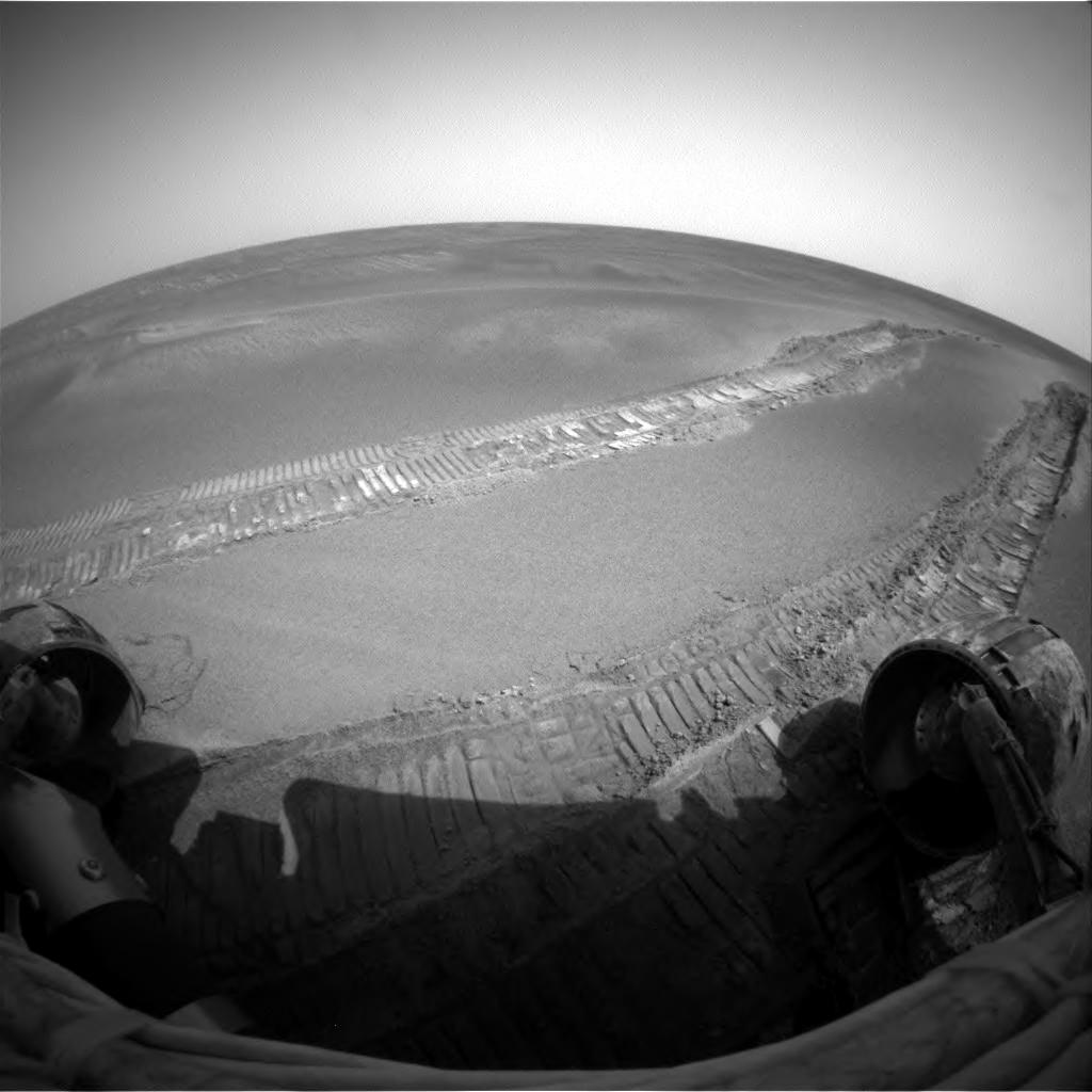
Posted by: alan Jun 23 2005, 05:39 AM
Hard to tell if its digging in or its just crushing the crest of the dune. More likely the latter.
Posted by: dot.dk Jun 23 2005, 05:53 AM
Later that day:
http://qt.exploratorium.edu/mars/opportunity/forward_hazcam/2005-06-20/1F172483402EFF55VMP1214L0M1.JPG
Posted by: Pando Jun 23 2005, 07:13 AM
Oh well, I got the sols mixed up... Time to go to bed...
Posted by: wyogold Jun 23 2005, 08:09 AM
I think you could get an idea from orbital photos of the tracks over time.
scott
Posted by: edstrick Jun 23 2005, 08:22 AM
"I think you could get an idea from orbital photos of the tracks over time."
I think it's already been reported from relatively recent MOC images that the older tracks have lost contrast.
Posted by: Tman Jun 23 2005, 08:31 AM
And the impact place of the heat shield which is even still older.
With it there are already three points on the graph.
Posted by: Sunspot Jun 23 2005, 10:26 AM
Maybe it would be better if they started driving again. Don't want them to get stuck again.
Posted by: Bob Shaw Jun 23 2005, 02:11 PM
There's no doubt that the tracks have become less clear, but that would only take a tiny amount of dust being swirled around. We *do* have a generalised dust sample device, in the form of the upper surface of each rover - and neither is showing much at present. There's the magnets, too...
...but whether a little of the global dust 'payload' being moved around is enough to have made the surface features, that's another story. If somebody came along and said the dunes were 100 MYO I wouldn't blink!
Posted by: abalone Jun 23 2005, 02:24 PM
With it there are already three points on the graph.
We also have the sample trenches dug by the arms of the Viking landers. One of them I believe lasted for many years..Viking 1 just over 7 years I think? Those trenches i dont believe showed a great deal of change either.
Posted by: Marcel Jun 23 2005, 02:41 PM
Does anyone reading this have any idea what those rates might be? 1mm/year? 1mm/century? 1mm/megayear?
No. Don't go back. Erosion and deposition rates can be derived from a lot of data that we allready have (yet, still has to be analyzed though). We have an awfull lot to learn about mothermaterial underneath this dunes in order to find out about earlier (wetter ?) processes and compositional data (though, the instrument sources are starting to be quite depleted i'm afraid, anyone has numbers on that ?).
For me, the one and only target nr. 1 is Victoria. Thats new science.....but it is also further away than ever
We'll see.Marcel
PS: Erosion rates at Mars nowadays have been studied extensively (i.e. by Dr. M. Golombek (MPF) and others). There's a lot of variability between sites and between materials. Deflation/depositional rates vary between 1 mm to 0,01 nm /year. There's also strong evidence that it has been VERY different (higher rates) in the past, compared to today. By the looks of it (not scientifically assessed, just my gut feeling as a ph. geographer) i'd say, that the dunes have been there for tens or even hundreds of millions of years, slightly changing over time. Wind action and erosion wiped out/covered all ejecta blocks (there's none present, besides "Fram" ejecta) around, which takes an awfull lot of time !
Posted by: JES Jun 23 2005, 02:42 PM
Recent micro - images show a mixture of berries and fines. I assume that berries are too large to be wind transported and this would suggest that the dunes are not as recent, having resulted from some other action besides winds alone.
On the other hand, this mixture of sizes creates a very strong matrix (highway bases are made of mixtures in size similar to this, to create a very strong base for pavement). I would think that such a mix should support the rover well. The fact that it pentrated the dune surface and dug in suggests a much weaker matrix such as one that assembled by wind blown fines. These dunes would continue to reshape continuously as winds shifted material.
On the other, other hand, I believe round shaped gravel, although it initially compacts better than irregular shapes, also behaves more like a fluidl than irregular shapes when disturbed laterally such as by wheels rotating.
On the other, other, other hand . . .
Posted by: Edward Schmitz Jun 23 2005, 07:30 PM
The dunes are currently evolving. We saw the difference in the 6 month old tracks at edurance and we saw it while they were stuck for a month. I will agree that the dunes have been there for a long time. The same way that the beach by my house has been there for a long time. The beach by my house is always changing and so are the meridiani dunes. It's not a case of how old - It's how fast?
http://marsrovers.jpl.nasa.gov/gallery/all/1/p/319/1P156501737EFF3940P2571L7M1.JPG
The older track in this image clearly shows the re-exposure of blue berries after Opportunity stomped them into the soil. That's erosion happening during the mission. And the soil had been compacted, to boot.
Posted by: Bob Shaw Jun 23 2005, 09:50 PM
The blueberries might (big 'might'!) be subject to some process similar to frost-heave which could make them jump out of the soil unless they're anchored by the duricrust...
Posted by: Edward Schmitz Jun 24 2005, 12:32 AM
Over a six month period? Doesn't that kind of process requires volatiles and you wouldn't you see a little pile of dirt around them as they erupted? I don't really know that much about it. Does anyone else think that might be what's happening?
ed
Posted by: Bill Harris Jun 24 2005, 01:55 AM
I think that the wind is simply eroding the fines from around the blueberries. I can't envision a mechanism that would make the blueberries pop out of the whell track.
--Bill
Posted by: helvick Jun 24 2005, 06:22 AM
There is a something that would do it but it needs quite a bit of ice - in permafrost zones on earth there's a process called boulder heave which pushes "solid" objects upwards out of soil that goes through a regular freeze\thaw cycle.
It might work without water - if the "soil" matrix has a significant thermal coefficient of expansion and the blueberries don't it could work just as well where the "soil" expands when heated.
Bery unlikely though as it would require that the soil is very well compacted which theimmediate zones around the wheel tracks don't appear to be.
My guess is that we're seeing mostly chemical change with a little bit of wind erosion that removes very fine material thus re-exposing blueberries\coarser dust.
Posted by: dilo Jun 24 2005, 06:29 AM
Sol503 360deg panorama (Navcam):
http://img292.echo.cx/my.php?image=pano5033sr.jpg
Posted by: Bob Shaw Jun 24 2005, 11:27 AM
On Earth, it works in temperate zones, too - farmers used to harvest stones off their fields in the spring, and gardeners still do. It wasn't a terribly *serious* suggestion, though!
Posted by: RNeuhaus Jun 24 2005, 01:41 PM
The only difference that I see the marks of Oppy's trail between 5 weeks is that the older is somewhat burried by very tiny dust (less constrat visual) than the new track ones.
Rodolfo
Posted by: Phil Stooke Jun 24 2005, 03:26 PM
Here is dilo's sol 503 pan in polar form... quite good for showing the activities after getting free.

|
Phil
Posted by: JRehling Jun 24 2005, 03:56 PM
To see year-old tracks they could go back several km, but to see month-old tracks they can sit still and look over Oppy's right shoulder! The preferable choice is obvious.
Posted by: dvandorn Jun 24 2005, 04:59 PM
Remember, too, that while there are a number of final failure modes for the rovers, one of the more likely sets of failure modes would leave us with a working rover that can't move -- or at least can't move very far.
The time to study changes over time is when we can't move and have very little left to do except scan our surroundings for changes. In fact, I think perhaps that the final extended mission for the rovers ought to be such a thing -- measuring local rates of erosion and deposition. That will be especially useful at Meridiani, I think.
-the other Doug
Posted by: pioneer Jun 24 2005, 05:17 PM
How far has Opportunity travelled since it was freed? I say we keep
Posted by: Analyst Jun 24 2005, 07:00 PM
Not much going on here, no drives, no IDD work. We are free for 3 weeks now but still stuck. A 180 turn in this time is bad, even for restricted sols and low solar power. I'm not for 100m drives per day, but some progress, science or movement.
Are there any problems with the rover? Or is Spirit the star this month?
Analyst
Posted by: Nirgal Jun 24 2005, 09:13 PM
Analyst
Steve's next update at http://athena1.cornell.edu/news/mubss/
will tell us ...
Posted by: Edward Schmitz Jun 24 2005, 09:37 PM
Wind tails!
We don't need to move or wait to see signs of erosion. There are obvious wind tails in opportunity's tracks from just two weeks ago. The dunes are active. And if you look again at the old vs. fresh tracks back at endurance, the cleet marks are filled in on the old tracks.
http://marsrovers.jpl.nasa.gov/gallery/all/1/n/484/1N171155474EFF55TIF0006L0M1.JPG
http://marsrovers.jpl.nasa.gov/gallery/all/1/n/494/1N172044102EFF55V4P1914L0M1.JPG
http://marsrovers.jpl.nasa.gov/gallery/all/1/p/484/1P171149599EFF55T4P2543R2M1.JPG
http://marsrovers.jpl.nasa.gov/gallery/all/1/p/496/1P172214421ESF55V4P2550L2M1.JPG
These new tracks are changing fast compared with the endurence example.
Posted by: Myran Jun 24 2005, 10:11 PM
That was a very insightful suggestion you made, even though you backpedaled a bit later, but I think it might be something to it since I have considered frost-heave as one explanation myself for those bluberries that appearently pop up.
We already discussed the possibility here when I looked at the image of that meteorite near the backshell with a friend who asked how it could be sitting so neatly on the surface. My suggestion then was indeed that it could be boulder-heave that have pushed it up over the millennia.
So I rather think you should take credit for it Mr Shaw, since I was too uncertain to speak up. I was simpy too hestitant airing the explanation since im fully aware that Mars is bone dry in comparision with the conditions when that happens on Earth.
Humidity could very well get trapped in the sand, and perhaps it doesnt need to be especially much ice as helvick suggested. The thin layer of humidity around each grain would expand as it freeze to ice and with a lot of sand it could result in quite some movement.
Regardless, on Earth the atmosphere do keep a bit of humidity even below freezing temperatures, and that very small fraction eventually freeze out when it gets really cold which it does on Mars.
So the bottom line is that I dont want to rule out the idea of frost or boulder heave yet.
Posted by: Bob Shaw Jun 24 2005, 10:50 PM
(Blush)
Ideas are *easy* - numbers is difficult!
Speaking of ideas... ...'frost heave' might be responsible for rocks migrating to the surface, but perhaps the mechanisms are not exactly as on Earth. Here, we're looking at things like ice expanding under rocks, while on Mars it might not work quite that way (obviously, ice still expands as it freezes!).
Perhaps it works *backwards* on Mars, with winter hoar frost leading to a salty dribble in spring which then either makes a sort of mulch which becomes duricrust, or - where there's a rock - does some heaving. Then all the water sublimes away, having gently distilled the soil...
We saw what may have been polygons at the Viking 2 site; saw plastic soil flows in Endurance and around rocks at Larry's Lookout; and have numerous bits of large-scale evidence for past surface ice effects, so it's not too speculative, is it?
And the notion that the Heat Sheild meteorite was heaved up to the surface is v-e-r-y interesting, too!
Posted by: Bill Harris Jun 24 2005, 11:22 PM
Yes, I've been watching those for a couple of weeks. I think the tails are especially noticable because the disturbed soil in the ruts is very fine evaporite material which is easily windblown. More clues as to the nature of this odd stuff!
--Bill
Posted by: dilo Jun 25 2005, 07:33 AM
will tell us ...
"restricted sols". This is what happens when Earth time and Mars time line up inconveniently...
So Oppy is almost inactive because they cannot pay people to work at night???
Or it is a DSN comm issue?...
Posted by: djellison Jun 25 2005, 04:51 PM
It's not a matter of people working at night - it's simply that the planning team involves the scientists and engineers, and for more than a year, they've been working from their home institutions on a normal work schedule. You just can not maintain mars-time for a prolonged period - it will burn you out.
Doug
Posted by: dot.dk Jun 25 2005, 05:35 PM
I just find it curious that Opportunity has spend 3 weeks out of the dune and the only things it has done is turn around a do a simple soil measurement.
Look at how much Spirit has done in the last 3 weeks
Posted by: Myran Jun 25 2005, 08:19 PM
Ideas are *easy* - numbers is difficult!
Speaking of ideas... ...'frost heave' might be responsible for rocks migrating to the surface, but perhaps the mechanisms are not exactly as on Earth. Here, we're looking at things like ice expanding under rocks, while on Mars it might not work quite that way (obviously, ice still expands as it freezes!).
Perhaps it works *backwards* on Mars, with winter hoar frost leading to a salty dribble in spring which then either makes a sort of mulch which becomes duricrust, or - where there's a rock - does some heaving. Then all the water sublimes away, having gently distilled the soil...
We saw what may have been polygons at the Viking 2 site; saw plastic soil flows in Endurance and around rocks at Larry's Lookout; and have numerous bits of large-scale evidence for past surface ice effects, so it's not too speculative, is it?
And the notion that the Heat Sheild meteorite was heaved up to the surface is v-e-r-y interesting, too!
Indeed, numbers and calculus for things like this are way beyong my capability.
But I think you are right again, When the humidity evaporates it would indeed leave the salts behind and could very well be the process that create the duricrust, and yes it would be unlike how it happen on Earth since the water go from frozen to a gas almost instantly.
To speculative? Not at all, images from orbit have shown several, please bear with me when I go completely off topic for this thread here. As for past surface ice effects I have spotted a number in images from Spirit. Have a look at the image I hotlinked below. At far right you might see a small darker conical hill.
If I would see one such conical pile in the arctic here on Earth I would instantly say its the kind of rubble pile left behind by a former glacier. The pile of rocks are deposited by the melt water creek that flows under the glacier where it is accumulated at the end of the glacial flow. Now this is Mars, so I dont say it really is that, but it is found at the end of a valley and the soft slopes of the Columbia hills could have been given their shape by glaciers.
http://marsrovers.jpl.nasa.gov/gallery/press/spirit/20040422a/x_pubeng_pan_hills-A108R1_br.jpg
Heat shield meteroite notion: My time to blush, I live in the northern temperate zone and have been one agricultural worker (growing potatoes), so the process of frost heave is very familiar to me. Some scientists considered it a mystery in the same league as paranormal phenomena, others simply said we lost a lot of topsoil with the meltwater.
Despite that we could see a large number of rocks that appeared in the fields each year when the snow melted away. And had to spend considerable time removing them every time before we could start growing our potatoes, if we didnt the rocks would get picked up by the harvesting machinery since they were of a similar size.
Yet it was in one of the last years when I had that occupation that a scientist actually was able to 'solve' the process behind it so the ability to use those 'difficult numbers' doesnt always provide a straightforward solution to a problem of this kind. So i would say that sometimes ideas are good enough and we worry about the math later.

Posted by: dilo Jun 26 2005, 05:56 AM
Doug, I understand the issue, but I still disappointed... Is sad to see Oppy inactive, especially after the fantastic work they made to free it! (Do we need and asiatic MER team?
)Anyway, do you know, approximately, when it will possible to restart normal activities?
Thanks.
Posted by: Sunspot Jun 26 2005, 07:35 AM
http://athena1.cornell.edu/news/mubss/
New update.
Posted by: Bill Harris Jun 26 2005, 10:36 AM
Squyres gave a reasonable update. It is a concern that Oppy is making such dismal progress, but I think that these conservative movements are a side effect of the complacency that had developed. Last month the Rover was nearly turned into a Surveyor when she hit unexpected terrain.
--Bill
Posted by: djellison Jun 26 2005, 05:55 PM
)Anyway, do you know, approximately, when it will possible to restart normal activities?
Thanks.
Restricted sols are an every-now-and-again thing, not a "rover off for 9 days" type thing
They mean that the rover can do stuff, but just nothing that requires people in the loop. It could spend the whole day doing a full remote-obs day or something like that
Doug
Posted by: Bubbinski Jun 26 2005, 09:22 PM
Oppy just put her arm out to examine the dune on Sol 505. From what I can tell of the microscopic images, some of the "pebbles" or "blueberries" were buried pretty deep in the sand. I don't know if they were the same blueberries found at Endurance and Eagle craters.
(Edited so I could attach the image, I didn't realize it would be so big. Trying to be kind to those with dial-up, like I used to have for so many years before getting cable)

|
Posted by: Bubbinski Jun 26 2005, 09:24 PM
Here's another shot of Oppy sticking out her arm at the dune that nearly snared her.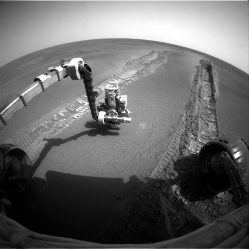
Posted by: Bubbinski Jun 26 2005, 09:37 PM
Here's another shot of Oppy's IDD on Sol 505, this time against her right wheel. Attached because an inline image would be pretty large on the page.

|
Posted by: mhoward Jun 26 2005, 10:20 PM
For raw images, you could just post a link rather than attach it... it might be good to save space on Doug's servers.
I've also been concerned about Oppy's progress recently. Squyres' update explains a lot, though. I hope we'll be rolling again soon.
Mega-kudos once again to Steve Squyres for doing these updates.
Posted by: dilo Jun 27 2005, 05:35 AM
Anyway, MI images are pretty interesting, especially the lower one, which should be taken in the "untouched zone" (based on the time of Hazcam picture) but show some collapsed BB... (natural or did MI inadvertitely pushed them?):
http://img198.echo.cx/my.php?image=sol505mi1wv.jpg
Posted by: dilo Jun 27 2005, 05:46 AM
Found answer:
stitching toghether the four MI images, collapsed region has clear circular shape, so should be due to Oppy pressure (probably done with Mossbauer spectrometer...); maybe also deliberated in order to test how sand is soft! :
http://img198.echo.cx/my.php?image=softsand9sm.jpg
Posted by: Jeff7 Jun 27 2005, 02:49 PM
stitching toghether the four MI images, collapsed region has clear circular shape, so should be due to Oppy pressure (probably done with Mossbauer spectrometer...); maybe also deliberated in order to test how sand is soft!
I second that - there's the large outer circle, and then there's a smaller, untouched circle in the center.
Posted by: RNeuhaus Jun 27 2005, 02:50 PM
Comments about the picture, This terrain has a mix of two types of sand, fine and blueberries.
I don't see any other strange things except to fine sand and Blueberries. Almost pure. No other mixing. No vegetation or marine residues from the old times as it is supposed that Meridiani Terrain was a sea.
Rodolfo
Posted by: Myran Jun 27 2005, 03:56 PM
I don't see any other strange things except to fine sand and Blueberries. Almost pure. No other mixing. No vegetation or marine residues from the old times as it is supposed that Meridiani Terrain was a sea.
Rodolfo
Well that what you would expect, here on Earth you can find seashells and wooden twigs on a beach because they are very recent. In less than a hundred years they will be grided down to sand or dust. White beaches often are made of the former, broken shells from sea living organisms.
If either kind of life ever have been found on Mars, the remnants would be long gone, sandblasted over hundred of millions of years. Fossils in bedrock can be preserved even then, but that takes a dedicated geologist human or robotic with tools to cut rock.
Yet the very low amount of organic material on the Martian surface make me wonder if the planet even could have had single cell life.
When I was a child, it was one almost universal belief that the planet had some kind of vegetation due to the changing appearance over the seasons seen from earth bound telescopes.
We know the truth now, but I still think Mars are one fantastically interesting place.
Posted by: ToSeek Jun 27 2005, 10:23 PM
We don't need to move or wait to see signs of erosion. There are obvious wind tails in opportunity's tracks from just two weeks ago. The dunes are active. And if you look again at the old vs. fresh tracks back at endurance, the cleet marks are filled in on the old tracks.
http://marsrovers.jpl.nasa.gov/gallery/all/1/n/484/1N171155474EFF55TIF0006L0M1.JPG
http://marsrovers.jpl.nasa.gov/gallery/all/1/n/494/1N172044102EFF55V4P1914L0M1.JPG
http://marsrovers.jpl.nasa.gov/gallery/all/1/p/484/1P171149599EFF55T4P2543R2M1.JPG
http://marsrovers.jpl.nasa.gov/gallery/all/1/p/496/1P172214421ESF55V4P2550L2M1.JPG
These new tracks are changing fast compared with the endurence example.
Better, perhaps to show images from the same angle:
http://marsrovers.jpl.nasa.gov/gallery/all/1/n/465/1N169468866EFF55E3F0006L0M1.JPG
http://marsrovers.jpl.nasa.gov/gallery/all/1/n/484/1N171150407EFF55T4F0006L0M1.JPG
I can't say I see much difference here.
Posted by: MahFL Jun 27 2005, 11:45 PM
Me neither, what are we supposed to see that's different ?
Posted by: Myran Jun 28 2005, 04:03 PM
MahFL you might have another look at the pan cam L2 - sol 496 image.
No comparision needed, in the wheeltracks you can see signs that the wind have been at work, its not dramatic, but its obviously there. I would rather say that is about what to be expected. Remember that this is Mars with an atmosphere of perhaps just 6-8 millibar. On Earth you could of course see a bigger change in a single day if it was a bit windy.
Posted by: RNeuhaus Jun 28 2005, 07:48 PM
I can see a small difference. The difference is that the edge of older track is more rounded than the new one.
Rodolfo
Posted by: Edward Schmitz Jun 29 2005, 03:20 AM
Ok, I thought it was obvious but...
http://marsrovers.jpl.nasa.gov/gallery/all/1/p/496/1P172214421ESF55V4P2550L2M1.JPG
Look carefully just below the center of the frame. There are stream lined little islands of dust with a blue berry at head. Wind tails! The wind direction is blowing cross frame and slightly away. The evidence is all over the frame. Take a look at the top track. There are tendrils of dark matterial streching across the track. They also cross multiple treads. And don't appear in the http://marsrovers.jpl.nasa.gov/gallery/all/1/p/484/1P171149599EFF55T4P2543R2M1.JPG. They would appear to be minor ripples that are marching along. Compare the treads between the earlier shot and this one. Or even the top track's treads and the bottom track. They are filling in and eroding away.
This, too me, is evidence that the dunes are currently active. So it is not a matter of how old are the dunes, but how fast are they changing.
Sorry for being too vague in my earlier post.
ed
Posted by: abalone Jun 29 2005, 09:47 AM
http://marsrovers.jpl.nasa.gov/gallery/all/1/p/496/1P172214421ESF55V4P2550L2M1.JPG
This, too me, is evidence that the dunes are currently active. So it is not a matter of how old are the dunes, but how fast are they changing.
ed
You have well and truely convinced me. The amount of change is more than I would have expected given the low pressure. This movement of the very fine particle also implies continual sand (dust) blasting and erosion of the surface blueberries and it follows that they must be right through the dunes.
I don't see how the blueberries could have come from anywhere else than where they currently lie and therefore the dunes are composed of material weathered from the underlying rock rather than blown in from elsewhere. What process could then be responsible for the removal of the salt portion of the underlying rock to leave this surface blanket. It can't be wind erosion since none of the bedrock here is exposed to the wind.
Could it be just simple diurnal temperature cycling over millions of years. The range is 100+ deg. How far down would you have to go to get a stable temp, 1/2m? 1m? that is just about the thickness of the dune material?
Posted by: Myran Jun 29 2005, 04:06 PM
Sorry RNeuhaus I wasnt referring at any rounding at all in the the pan cam L2 - sol 496 image but the streaks with a pebble at the front end and semi-circles.
So Edward Schmitz are correct and we both happened to look at the same thing, it was the 'darker material' and 'streaks' I was referring to.
Posted by: jvandriel Jun 30 2005, 10:26 AM
Another panorama of an Mossbauer imprint in the wheeltrack of Opportunity at Purgatory Dune.
Taken with the MSI Cam on sol 507.
jvandriel

|
Posted by: john_s Jun 30 2005, 03:48 PM
This, too me, is evidence that the dunes are currently active. So it is not a matter of how old are the dunes, but how fast are they changing.
That's impressive- thanks for pointing out the changes. I'm not sure this is evidence for active dunes, though. The tops of the dunes are armored by a layer of blueberries and/or other coarse debris. Oppy's wheels have disturbed that armor, exposing fine dust which is then easily picked up and moved by the wind. The dunes themselves may not move unless the wind is strong enough to disturb the armor or somehow pick up grains from beneath it.
Posted by: dilo Jul 1 2005, 06:10 AM
Mossbauer intrument made some pressure inside the right track (Sol 507)  :
:
http://img86.imageshack.us/my.php?image=mossbauerimprint1zi.jpg
Posted by: RNeuhaus Jul 1 2005, 01:40 PM
:http://img86.imageshack.us/my.php?image=mossbauerimprint1zi.jpg
Incredible fine sand like a powder.
It looks that the sand has somewhat humidity because of the presence of cracks. Who else can tell more about this? Rodolfo
Posted by: dvandorn Jul 1 2005, 02:45 PM
A fine enough powder acts like this in the complete absence of moisture -- in fact, moisture keeps a fine powder from acting this way. Try pressing some flour down onto a plate and see what it looks like... you'll get cracks like this.
-the other Doug
Posted by: Jeff7 Jul 1 2005, 02:57 PM
-the other Doug
Thing is though, a dry day on Earth would probably be outright dank and humid for Mars. This is low grav, low air pressure powder here.
Posted by: dvandorn Jul 1 2005, 03:02 PM
Yes, but an average day on Mars would be considered tremendously dank and humid (and air-filled) on the Moon, and you see lunar dust forming cracks like this, too. In the complete absence of air and water.
It has to do with the grain size and morphology -- fine powders become somewhat self-cohesive, especially in a vacuum or under low pressure. That's what causes the cracking action. As I said, it even works in our own atmosphere with most fine powders.
-the other Doug
Posted by: RNeuhaus Jul 1 2005, 04:46 PM
It has to do with the grain size and morphology -- fine powders become somewhat self-cohesive, especially in a vacuum or under low pressure. That's what causes the cracking action. As I said, it even works in our own atmosphere with most fine powders.
-the other Doug
I agree with you since I have ever observed the powder behavior. The powder has somewhat static attraction property that unites among powders.
Rodolfo
Powered by Invision Power Board (http://www.invisionboard.com)
© Invision Power Services (http://www.invisionpower.com)