Printable Version of Topic
Click here to view this topic in its original format
Unmanned Spaceflight.com _ Opportunity _ Erebus Ho!
Posted by: djellison Jul 26 2005, 10:10 AM
Some L2/L7's came down and I've done a whole lot of channel-mixing to get something fairly nice. 
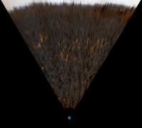
http://www.unmannedspaceflight.com/doug_images/o533_71.jpg (600kb)
And because it highlights the features ahead so brilliantly - i've done the interesting section in 500% Phil-O-Vision
http://www.unmannedspaceflight.com/doug_images/o533_71_pov.jpg (60kb)
Who wants to play 'match the feature' with that and MOC imagery 
Doug
Posted by: chris Jul 26 2005, 10:49 AM
Doug,
You to yourself an injustice. Fantastic.
Chris
Posted by: Sunspot Jul 26 2005, 11:42 AM
Lovelly picture Doug. After all this waiting, I hope Erebus turns out to be more impressive than Vostok lol. I've often wondered where Opportunty might be right now if it hadn't got stuck... although I suppose it could have got into trouble on a dune further down the line.
Posted by: djellison Jul 26 2005, 11:52 AM
Looking at the Phil-O-Vision image I thikn Erebus could actually be a nice panorama - several feet of outcropping it looks like. A strange, new, and unusual vista I am sure 
Doug
Posted by: Bill Harris Jul 26 2005, 12:35 PM
Yes! You can already see dunes and ?outcrops? of the dark "basal unit" within Erebus.
I think that getting stuck was inevitable. Oppy was travelling uncommanded at high speed and the conditions/terrain were clearly changing before she got stuck. The Purgatory incident was a wake-up call; it could have been worse.
--Bill
Posted by: algorimancer Jul 26 2005, 02:52 PM
I'm curious - is everyone else seeing this (and many other Meridiani panoramas) as nearly black? I have to enhance the intensity in order to actually see what's going on. Is this an aesthetic choice, to match a perceived expectation of the actual lighting at Meridiani, simply a matter of preserving the intensity from the original images, or do I need to adjust my monitor?
Incidentally ... with the intensity enhanced, nicely done, and it's good to see Erebus.
Posted by: djellison Jul 26 2005, 03:02 PM
It's far from black on all the systems I use...CRT's at work ( two different ones ) LCD on my laptop, and LCD for my home machine
Perhaps you need to fiddle with contrast/brightness?
Doug
Posted by: Phil Stooke Jul 26 2005, 03:51 PM
Here:

|
I compare views of Erebus from sols 448 and 533. The first was my original posting, the second cribbed from Doug.
My impression is that on 448 we could see a bit more to the south, as if the rover was then up on a slight rise, and now the view is from a slightly lower area. This may explain why we have had so much difficulty seeing anything. I have always thought the etched terrain should be very interesting and scenically attractive, but it's one of those things you don't see until you are right on top of it.
As for matching this to MOC images... I'm not ready to do that yet. Got burned with Home Plate!
Phil
Posted by: Bill Harris Jul 26 2005, 04:00 PM
Perhaps you need to fiddle with contrast/brightness?
Monitor settings have always been a problem with digital viewing. Perhaps we ought to have a "monitor calibration" page onsite; here is the calibration page from my site:
http://www.mindspring.com/~woharris/cal.htm
Doug, PM me if you'd like to use any of these materials here.
--Bill
Posted by: algorimancer Jul 26 2005, 04:25 PM
http://www.mindspring.com/~woharris/cal.htm
Doug, PM me if you'd like to use any of these materials here.
--Bill

Thanks Bill, that did the trick. My contrast was off. Much better now
Posted by: dilo Jul 26 2005, 08:47 PM
Phil, I think you're right! In fact, this explain also why I wasn't unable to make decent vertical projection from Sol 531 partial panorama...
:

|
looking to tracks divergence, I things that in that Sol Oppy was descending...
Posted by: Bill Harris Jul 27 2005, 11:17 PM
Here is an interpretation of Doug's o533_71_pov.jpg image. I used PaintShopPro to set the grey, white and black points of the image to remove the "mars dust" color bias from the image. In this way one can see compositional differences in the surface materials by "dusting".
--Bill
Posted by: dot.dk Jul 28 2005, 01:47 AM
According to the latest flight director update Opportunity will only be 150 meters from Erebus crater after todays drive (SOL 536)!
http://www.jpl.nasa.gov/missions/mer/flightdir.cfm
Posted by: skybum Jul 28 2005, 05:28 AM
Heck with Erebus: Victoria ho? Is anybody else thinking that the little 5-6 pixel rise immediately to the right of Erebus looks a bit hazy, as if from distance, and is in exactly the right direction...?
Posted by: dilo Jul 28 2005, 06:20 AM
If you look to traverse map, this is impossible:

|
From actual position (in red) Victoria should appear about 40deg east of Erebus, approxiametly between the two red marks in this stretched Doug's panorama:

|
Probably, Oppy is too far (and even in a depressed region) to see Victoria rim... the feature you highlight is the Erebus rim...
Posted by: Phil Stooke Jul 28 2005, 02:37 PM
Doug asked if anybody wanted to try matching features between pancam and MOC as we approach Erebus. Well, never let it be said Phil was afraid to take a chance. I've been wrong before but here goes:

|
This is a comparison of the MOC image (south at top) and the vertically exaggerated pancam view from Sol 448 which I posted long ago. I have indicated some dark patched (D1, D2) and ridges (R1, R2). The ridges are probably just dunes. The one which is on the horizon on Sol 533 is the one on the right in this older picture, I think.
OK, rip me apart, ye lions!
Phil
Posted by: Bill Harris Jul 28 2005, 03:47 PM
I hate to make this type of post, but "I agree".
In my color-tweaked exaggerated Phil-O-Vision Stooke-gram in Post #12, we see, from right to left, R-1/R-2 dunes/ridges, and the D-1 and D-2 dark outcrops. The evaporite-paved Erebus Highway moseys from the bottom center to the left horizon. Note the dunes/talus on the far wall between the dark outcrops. I'm interested in examining the dark unit since this appears to be our first major change in lithology since we've been here.
Evaporites, basalt sand, blueberries and misc ejecta/aerolites are interesting, but after a year, we need a change...
--Bill
Posted by: gregp1962 Jul 28 2005, 04:43 PM
I'm with Skybum. I predict that Erebus will be like Vostok. Only, not so exciting
Posted by: avkillick Jul 28 2005, 05:42 PM
I'm secretly hoping (not so secret any more) that there is nothing of interest at Erebus and Oppy continues full steam to Victoria.
Posted by: tedstryk Jul 28 2005, 05:52 PM
I ride the fence on this. If it looks like Vostok, I hope that the rocks aren't too interesting so we can get moving. If it turns out to look like nothing we have seen before, I hope we take our time and explore the place.
Posted by: sapodilla Jul 28 2005, 06:27 PM
I think that Erebus crater and Etched terrain is the same bedrock as Oppy seen before, therefore the next big (long) stop would be Victoria and I hope the slope isn`t too steep so Oppy can drive into Victoria and find deeper layers of bedrock to examine.
Posted by: Sunspot Jul 28 2005, 06:48 PM
If Opportunity reached Victoria and sent back a nice panorama of it i'd be very happy.
getting closer:
http://qt.exploratorium.edu/mars/opportunity/pancam/2005-07-28/1P175773098EFF57KRP2443L2M1.JPG
Posted by: dilo Jul 28 2005, 06:58 PM
Phil, now agree with you! At least identifications of the two rim features appear very reasonable. Here last stretched panorama (10:1) from new Sol536 PanCam:

|
I tried to make a vertical projection (assuming flat terrain); scale is uncertain, due to the fact that terrain is not flat in front of Oppy, but is possible to identify some details of the highway in the MOC image; this help to identify also rover position:

|
Posted by: general Jul 28 2005, 07:45 PM
Don't underestimate the distance between Erebus and Victoria (about a mile) - and the 'etched terrain' between those two craters looks like an obstacle course full of sand traps and rocky ridges. It'll be a miracle if Opportunity ever reaches Victoria Crater.
Posted by: dilo Jul 28 2005, 08:37 PM
This is exactly the kind of miracles that MER team usually made in the last 18 months 
Posted by: dilo Jul 28 2005, 09:50 PM
Now highway features identifications are more easy:

|
Here also the polar projection:

|
Posted by: Bill Harris Jul 28 2005, 11:21 PM
Let me corret myself: it looks like the "dunes/talus on the far wall between the dark outcrops" that I noted earlier are at the near crater rim.
I'm looking forward to seeing Erebus up close.
--Bill
Posted by: skybum Jul 29 2005, 03:01 PM
Dilo -- thanks for the correction on my Victoria over-enthusiasm. I didn't have an overall MOC image showing both Erebus and Victoria readily available, so I searched and searched, and when I finally found one it was at a weird angle that led me to believe that Opportunity was located more west of Erebus than North. Alas.
Still, I cannot wait to see Victoria! Any chance that we might be able to see it from that rise on Erebus' rim?
Posted by: jvandriel Jul 29 2005, 05:06 PM
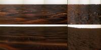
Panoramic view to the South.
Erebus on the right side of the picture in the background.
Taken with the L2 Pancam on Sol 536.
jvandriel
|
|
Posted by: RedSky Jul 31 2005, 11:57 AM
Looks like the on-ramp to the Erebus highway!
http://qt.exploratorium.edu/mars/opportunity/navcam/2005-07-31/1N176036579EFF57LRP0703R0M1.JPG
Posted by: Bill Harris Jul 31 2005, 12:12 PM
Indeed! I've been noticing the chanes in terrain the past couple of "days of exploratorium postings".
This is a recent image, contrast enhanced and sharpened:
I see a couple of the flat evaporite paving plates that have apparently sunk, leaving a depressed area in the overlying soil. Not much in the big picture, but an interesting data point nonetheless. "Hmmm..."
--Bill
Posted by: dilo Jul 31 2005, 11:39 PM
Finally we have a pseudocolor PanCam stitch (Sol539, L2+L7):
http://www.unmannedspaceflight.com/index.php?act=Attach&type=post&id=1039
And corresponding Phil-O-Vision (x10 stretch, more realistic colors):
http://www.unmannedspaceflight.com/index.php?act=Attach&type=post&id=1040
..and (almost) vertical projection:
|
Posted by: Bill Harris Aug 1 2005, 04:05 AM
And here is a Phil-O-Vision Horticolor image; much nicer colors that I was able to prestidigitate.
Note that the near-rim dunes are marching around to the right side. It looks like Oppy's aiming for the eastern rim of Erebus...
--Bill
Posted by: Phil Stooke Aug 1 2005, 04:16 AM
I really must do something about this awful astigmatism...
Phil
Posted by: Burmese Aug 1 2005, 01:54 PM
I'm betting they stop and do a bit of scratch-and-sniff at the exposed patch a few meters ahead.
http://marsrovers.jpl.nasa.gov/gallery/all/1/n/539/1N176036579EFF57LRP0703L0M1.HTML
Posted by: David Aug 1 2005, 09:02 PM
It looks as though, if you could sweep away the dunes (which look much lower and flatter here), that there would be a broad cobblestoned pavement all the way to the south. Is that possible?
Posted by: Jeff7 Aug 2 2005, 01:42 AM
Easy way to find out - send one of those street-cleaning trucks to Mars and let it have a go at it. Just think of all the science - analysis of the dust passing through the collection tank, a good look at clean stones, information on how fast the dunes move, and a clear path for Opportunity.
Posted by: CosmicRocker Aug 2 2005, 03:18 AM
Actually David, that is almost certainly the case. From what we've seen in the occasional windows through the dunes/ripples, the bedrock surface has been mostly flat and cracked up from Eagle crater to Endurance, and all the way south to the current position. I am hoping that when Opportunity gets well into the etched terrain, it will become less flat, with some elevated outcrops to explore.
Posted by: mike Aug 2 2005, 05:44 AM
The question is, is it worth it to spend any time on outcroppings when a huge crater awaits a few meters to the south? I think it would be quite interesting to see just what that meteor uncovered however long ago, moreso than more finely layered bedrock nubs. If nothing else a panorama of a huge crater would be impressive to see.
I wouldn't mind seeing a fossilized whale skeleton sticking out of the Meridiani plains, though.
Posted by: Nix Aug 2 2005, 05:59 AM
Victoria will be awesome no doubt, but there is a slight chance IMO the outcropping near Erebus will be easier to investigate. Looking at Victoria it looks like a though one to enter compared to Endurance and the ejecta blanket seems covered by dark sands.. Perhaps they will need to travel some time around it to determine a safe way to the rim. 'bout your skeleton, who wouldn't? 
Nico
Posted by: dilo Aug 2 2005, 06:39 AM
Sol540 PanCam stitches toward SE (up) and West (bottom); corresponding stretched version on the right (10:1 ratio) suggests a slope of only 0.22 degree toward erebus...
|
Posted by: Sunspot Aug 2 2005, 08:52 AM
http://marsrovers.jpl.nasa.gov/gallery/all/1/n/539/1N176036579EFF57LRP0703L0M1.HTML
Lucky you didn't put any money on that bet lol
http://qt.exploratorium.edu/mars/opportunity/rear_hazcam/2005-08-02/1R176214915EFF57PYP1311R0M1.JPG
Posted by: Tman Aug 2 2005, 09:16 AM
It could also likely be that the outcrops at Erebus are the same stuff as before - then we ride rather fast along I guess, because we can hope to find unusual ejected rocks from a deep Victoria layer.
Posted by: Tesheiner Aug 2 2005, 10:01 AM
Looking to sol 541 drive images and to this small pano made with the pancam pictures, I have the feeling that they will stop on the next collection of patches.
See http://nasa.exploratorium.edu/mars/opportunity/navcam/2005-08-01/1N176215046EFF57PYP0703L0M1.JPG
and
|
Tesheiner
PD: I'm just coming back from my month-long vacations and trying to figure what happened on mars during this time.
Posted by: Nirgal Aug 2 2005, 12:29 PM
I hope so !
if we could maintain the current driving regime (carful, but steady, daily progress at an average of 30 meters a day, *without* extensive stops ), we would cover the remaining 1500 Meters from Erebus to Victoria within about 50 Sols
add to this: restricted sols and another month of unexpected delay/problems, we
could be there as early as November...
Sooo, consulting Helvick's Power Chart, that would leave us still another 50-100 Sols worth of explorating Victoria Crater until Solar power death ...
Posted by: djellison Aug 2 2005, 12:59 PM
Phil
We need a new name for Phil-O-Vision
Vertical Exageration doest quite sound cool enough. Perhaps we could call them a Prolix, as Prolix is latin for long or stretched?
Doug
Posted by: Burmese Aug 2 2005, 01:29 PM
http://marsrovers.jpl.nasa.gov/gallery/all/1/n/539/1N176036579EFF57LRP0703L0M1.HTML
Bah! No stopping here!
http://marsrovers.jpl.nasa.gov/gallery/all/1/r/541/1R176214915EFF57PYP1311L0M1.JPG
Drove over the patch like a dog in the road. They're really in a rush!
Posted by: Bill Harris Aug 2 2005, 01:53 PM
Doug, you're not suggesting Prolixographs? Ugh. 
Stookeygrams have a homey ring, no? 
Yep, the patch looks like a roadkill. I'd like to see her stop and look at one of these bedrock windows, but I doubt that there is anything different here than what we'd see 200 meters down the road.
--Bill
Posted by: djellison Aug 2 2005, 02:01 PM
Anaglyphs and Proliglyphs works for me
Doug
Posted by: mhoward Aug 2 2005, 02:57 PM
Here is the context for Oppy's Sol 541 pancams:
http://www.flickr.com/photo_zoom.gne?id=30622737&size=o
(My question is: Are we actually looking at Erebus crater on the horizon? Is the ridge we see on the horizon actually the *far* side of the crater? Is it just completely filled in?)
Posted by: antoniseb Aug 2 2005, 03:56 PM
Hi, I'm new to this forum.
How far is Opportunity from Erebus right now? The most recent map on the public website is a couple of weeks old, and I'd be guessing that Opportunity should be practically on the rim of the crater right now, but the newest raw images don't suggest that at all (of course in one direction the images are consistantly very dark, so who can tell?).
Posted by: djellison Aug 2 2005, 04:08 PM
I'd push a guess at 150m
Doug
Posted by: Phil Stooke Aug 2 2005, 04:44 PM
"We need a new name for Phil-O-Vision"
So!! I go away for a few days and already the vultures are circling...
Phil
(sneaking a peek while on vacation)
Posted by: Sunspot Aug 2 2005, 05:10 PM
A new update on the JPL Rover website:
OPPORTUNITY UPDATE: Exploring Southward - sol 531-537, August 02, 2005:
Opportunity continued its trek south toward "Erebus Crater," making 61 meters (200 feet) of progress over two sols of driving. The rover is approaching greater quantities of outcrop as it heads south, and the team is excited at the possibility of using the robotic arm before reaching Erebus.
This week, restricted sols allowed the team to drive only every other sol. Next week, however, there will be a shift back to an early planning cycle that will allow driving every sol if desired.
Posted by: Bill Harris Aug 2 2005, 07:03 PM
I'm thinking that the ridge on the horizon is the far rim/wall of Erebus. See my
Phil-O-Vision'd Hortigraph in Post #33 of this thread. There is no concrete data to back up this thought; it just looks far enough in the right direction to be Erebus.
We'll see what we see when we see it...
--Bill
Posted by: ilbasso Aug 2 2005, 07:20 PM
I vote for keeping Phil-O-Vision. If we can have a Moessbauer spectrometer, why not name another investigative tool after its inventor (or implementer)?
Jonathan
Posted here on "Ellison's Folly"
Posted by: ToSeek Aug 2 2005, 07:46 PM
How far is Opportunity from Erebus right now? The most recent map on the public website is a couple of weeks old, and I'd be guessing that Opportunity should be practically on the rim of the crater right now, but the newest raw images don't suggest that at all (of course in one direction the images are consistantly very dark, so who can tell?).
The July 26 http://www.jpl.nasa.gov/missions/mer/flightdir.cfm said that after the next day's drive they'd be about 150 meters away. But that's about six sols ago now.
Posted by: CosmicRocker Aug 3 2005, 05:13 AM
When a geologist traverses a series of outcrops, one cannot predict which part will attract his/her attention. Something as small a a pebble, or even a sand grain may warrant a pause. As of sol 541 imagery, Opportunity is surrounded by more outcrops than it has seen closely in many sols.
"Opportunity continued its trek south toward "Erebus Crater," making 61 meters (200 feet) of progress over two sols of driving. The rover is approaching greater quantities of outcrop as it heads south, and the team is excited at the possibility of using the robotic arm before reaching Erebus."
http://marsrovers.jpl.nasa.gov/mission/status.html#opportunity
Posted by: dilo Aug 3 2005, 06:29 AM
Even closer on Sol541:

|

|
(in the vertical projection, I used also two PanCam images, like mhoward combo).
Posted by: ToSeek Aug 3 2005, 07:22 PM
There seems to be an annoying inverse correlation between what the geologists find interesting and what I find interesting. The rock guys are looking for stuff they can stop and analyze to death - I just want to see photos of a new and different landscape!
Posted by: Bill Harris Aug 3 2005, 08:15 PM
Not really. Every outcrop is a window into the subsurface and it helps to look and see what changes have occurred between Points A and B.
Remember, the importance of Geology to Geography is that without Geology, Geography would have nothing to rest upon...
--Bill
Posted by: RedSky Aug 3 2005, 10:24 PM
OK.... which is the FAST Lane??
http://marsrovers.jpl.nasa.gov/gallery/all/1/n/542/1N176303058EFF5800P0703L0M1.JPG
Posted by: Sunspot Aug 3 2005, 10:36 PM
Bedrock.........!!! I think they might stop soon and do some IDD work.
I wonder how far they drove this last sol, cant make out the outcrops in this forward hazcam image in the one taken the previous sol.
Sol 542: http://marsrovers.jpl.nasa.gov/gallery/all/1/f/542/1F176302941EFF5800P1214R0M1.JPG
Sol 541: http://marsrovers.jpl.nasa.gov/gallery/all/1/f/541/1F176214879EFF57PYP1214R0M1.JPG
Posted by: Nirgal Aug 3 2005, 11:34 PM
I wonder how far they drove this last sol, cant make out the outcrops in this forward hazcam image in the one taken the previous sol.
Sol 542: http://marsrovers.jpl.nasa.gov/gallery/all/1/f/542/1F176302941EFF5800P1214R0M1.JPG
uh oh ! I bet they will turn her a little bit to the right ... and not straddle that dune crest again ... or to cross the crest perpendicularly instead
Posted by: mhoward Aug 4 2005, 04:58 AM
http://flickr.com/photo_zoom.gne?id=31042494&size=o
Posted by: dilo Aug 4 2005, 06:19 AM
Steady progress... here the comparison of the two last Sols "vertical" projections (red triangle show new position):

|
Posted by: Tesheiner Aug 4 2005, 07:47 AM
It's just my imagination or have those pictures been available FIRST on the MER website then on the Exploratorium?
Last images on qt.exploratorium.edu are from sol 541.
Tesheiner
Posted by: Tesheiner Aug 4 2005, 09:24 AM
here the comparison of the two last Sols "vertical" projections (red triangle show new position):|
|
Given that position I would say that we are here:

|
(The background image was posted by Phil Stooke).
Posted by: jvandriel Aug 4 2005, 11:06 AM
Bedrock on the way to Erebus.
Panoramic view taken with the L Navcam on sol 542.
jvandriel

|
Posted by: general Aug 4 2005, 11:48 AM
Roman road? 
http://marsrovers.jpl.nasa.gov/gallery/all/1/f/543/1F176395707EFF5847P1214R0M1.JPG
http://www.utexas.edu/courses/romanciv/life%20and%20society/basalt.jpg
Posted by: Sunspot Aug 4 2005, 12:11 PM
Cool !!!
When was the last time Oppoprtunity had her wheels on solid rock?
Posted by: djellison Aug 4 2005, 12:28 PM
When was the last time Oppoprtunity had her wheels on solid rock?
http://marsrovers.jpl.nasa.gov/gallery/all/1/f/423/1F165741975EFF52GHP1215L0M1.HTML
I think
Doug
Posted by: tty Aug 4 2005, 12:32 PM
http://marsrovers.jpl.nasa.gov/gallery/all/1/f/543/1F176395707EFF5847P1214R0M1.JPG
http://www.utexas.edu/courses/romanciv/life%20and%20society/basalt.jpg
That looks rather like frost polygons.
tty
Posted by: Burmese Aug 4 2005, 12:48 PM
Last images on qt.exploratorium.edu are from sol 541.
Maybe they hired some new, hyperactive interns to handle the daily work of posting raw images to the MER web site.
Posted by: Bill Harris Aug 4 2005, 01:08 PM
>That looks rather like frost polygons.
Or mudcracks.
On jvandriel's sol542 pan, there are a couple of those odd sunken plates on the right side. I don't think they will be terribly significant in the long run, but they are odd enough to make me go "hmmmm" when I see them.
Very strange. I guess we call this the "Via Meridiani"...
Posted by: TheChemist Aug 4 2005, 01:31 PM
On Sol543 we are sitting on top of the far end of the middle outcrop in jvandriels Sol542 panorama. Time for the instruments to do some science ?
Posted by: ustrax Aug 4 2005, 02:13 PM
Or mudcracks.
On jvandriel's sol542 pan, there are a couple of those odd sunken plates on the right side.
Very strange. I guess we call this the "Via Meridiani"...
What an appropriate choice Bill!!!
Hope the guys bak there read the suggestion...
Via Meridiani est Spirictus iter ad Erebus.
Posted by: ustrax Aug 4 2005, 02:17 PM
Hope the guys bak there read the suggestion...
Via Meridiani est Spirictus iter ad Erebus.
Sorry...That should be
'Via Meridiani est OPPORTUNITATE iter ad Erebus.'
Posted by: ustrax Aug 4 2005, 02:36 PM
Here you go Bill:
http://i16.photobucket.com/albums/b14/ustrax3/VIA.jpg
Posted by: Bill Harris Aug 4 2005, 03:03 PM
>Here you go Bill:
Thanks; we're all immortalized now...
--Bill
Posted by: Nirgal Aug 4 2005, 03:55 PM
what a great, great luck !
not long ago we wonderd if the edged terrain could be almost untraversable
mixture of ragged rock obstacles and sand traps....
And now we find the way to Victoria literally paved in-between the sand dunes which also just happen to run in exactly in the right north-south direction...
and all supported by sympathetic martian winds, taking care of cleaning our solar panels ...
what a great luck to witness this amazing journey !
:-)
Posted by: SkyeLab Aug 4 2005, 04:05 PM
Do you reckon Erebus is a submerged one of these? :
http://www.holisticforgeworks.com/gallery/digital_photography/img/italy.colosseum.jpg
Posted by: David Aug 4 2005, 04:56 PM
http://i16.photobucket.com/albums/b14/ustrax3/VIA.jpg
I'm not certain what you're trying to say there, but there's no such form as "nominem" since "nomen" is neuter (accusative is the same form as nominative). Perhaps you mean something like "nominis genitor" (begetter of the name)?
"Guillelmus" might be better than "Guillermus".
And I think maybe you were looking for the dative of Opportunitas, not the ablative: Opportunitati?
Oh yes: ad Erebum (or in Erebum) rather than ad Erebus.
(Sorry -- Latin in H.S. and college)
Posted by: jvandriel Aug 4 2005, 05:02 PM
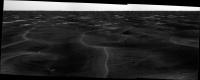
A Panoramic view of the Bedrock.
Have we seen it before?
Taken with the L7 Pancam on Sol 543.
jvandriel

|
Posted by: jvandriel Aug 4 2005, 05:59 PM
A complete 360 degree panorama at the Bedrock Station.
Taken with the L Navcam on Sol 543.
Look at the Drivers Skill.
jvandriel
|
|
Posted by: RedSky Aug 4 2005, 06:21 PM
Once in a while, looking at these MER pictures, a certain feeling will hit me and I'll just be taken aback by what I'm looking at. This picture, for example:
http://marsrovers.jpl.nasa.gov/gallery/all/1/n/543/1N176396406EFF5847P0607L0M1.JPG
At first, its pretty much like what we've been seeing for months now. But then, when its enlarged to full size and fills the monitor... it hits you... the "Dune Sea"... (didn't Obi Wan "live on the other side of the Dune Sea"?) Not only does this look like we're standing on the shore of a sea... but to think that at one time, it *WAS* a sea, and may have looked a lot like this with H2O waves instead of sand dunes and blueberries.
To think that all that evaporate paving (from the large quantities of water) underlie all these dunes for as far as the eye can see! Amazing!
Posted by: Burmese Aug 4 2005, 06:58 PM
I think I can pick out the -tiniest- hint of the edge of Endurance crater way in the distance. Probably the last day that will be possible, at least with NavCam.
Posted by: David Aug 4 2005, 07:40 PM
I had thought that I could pick out these sharply defined, large parallel units of bedrock from one of the route maps, but I can't seem to find them. Can anyone help me?
Posted by: bergadder Aug 4 2005, 08:29 PM
...
Do I see some crack in the bedrock at approx the 2 oclock position, leading off towards the horizon?
Posted by: Trader Aug 4 2005, 09:21 PM
bergadder,
Absolutely:
http://marsrovers.jpl.nasa.gov/gallery/all/1/n/543/1N176396140EFF5847P0703L0M1.JPG
I've been waiting for geo comments!
Trader
Posted by: TheChemist Aug 4 2005, 10:26 PM
There's a crack in the bedrock, what I'magonnado
There's a crack in the bedrock, what I'magonnado
I'm gonna RAT that crack, that's I'mgonnado
I'm gonna RAT that crack ....
Sorry, once it got stuck in my head I had to get it out 
My sincere apologies to UB40 too (where's the Rastaman smilie ?)
Seriously though, dirctionwise Anatolia was going East-West, if I remember correctly.
Isn't this crack North-South more or less ?
Posted by: Bill Harris Aug 4 2005, 10:48 PM
Phil Stooke's route map is pretty good, and oft-quoted. Here is one for sol542-- I've set the white/black points to make the evaporite bedrock exposures stand out, and have sharpened it a tad.
If the dunes/bedrock are trending N-S, then this anatolia fracture does appear to trend NE-SW. Also, in the Oppy image in Trader's post, the anatolia fracture trends SW towards the R1/R2 bump on the horizon, so the trend direction is confirmed.
I've got honey-do's to do and plan to do a Philo-O-Vision exaggeration, unless someone beats me to it...
--Bill
Posted by: Trader Aug 4 2005, 11:03 PM
Bill,
Am I seriously confused?? I see the R1/R2 "bumps" to the SE now SW so that it would not correspond ... ?
Trader
Posted by: Trader Aug 4 2005, 11:08 PM
Oops,
Above map is obviously South-up -- SW is correct and does correspond!!
Trader
Posted by: TheChemist Aug 4 2005, 11:32 PM
Indeed, anatolia was NE-SW. Now that I look at it, several troughs/cracks in this image close and beside Endurance also have the same directional trend.
Posted by: bergadder Aug 5 2005, 02:18 AM
Ok, so I am not seeing some image prosessing issue, but a Crack or trough.
So, what can we understand from them running SW from the current position, in line with these same items seen near Endurance? Can they explain the small depressions we observed in this trip over the sea of sand?
Posted by: glennwsmith Aug 5 2005, 03:56 AM
[QUOTE]Once in a while, looking at these MER pictures, a certain feeling will hit me and I'll just be taken aback by what I'm looking at.
RedSky, I know what you mean. I remember when Oppy first peaked out of Eagle Crater (I think it was looking to the NW), and you could see these neat dune fields. It's what Mars is supposed to look like . . .
Posted by: ustrax Aug 5 2005, 08:44 AM
"Guillelmus" might be better than "Guillermus".
And I think maybe you were looking for the dative of Opportunitas, not the ablative: Opportunitati?
Oh yes: ad Erebum (or in Erebum) rather than ad Erebus.
(Sorry -- Latin in H.S. and college)
David, I didnt had the pleasure of studying latin, I spent five years around Marketing, what has allowed me a job which provides me now the possibility of learning what I want to learn and this means...a lot of stuff, from languages (this forum is a good course for me...), archeology, space exploration, biology...The only problem is that I dont get quite focused on any of them, a bit of this a bit of that...
About latin, my language derives from it (portuguese) so it is possible that some mistakes came from the bad habit of thinking like: OK, in portuguese is like this, in latin must be like...
Lets see where I was wrong...
but there's no such form as "nominem" since "nomen" is neuter (accusative is the same form as nominative). Perhaps you mean something like "nominis genitor" (begetter of the name)?
Yes...I like nominis genitor...but nominem exists:
Adiuva nos, dive maxime,
quod per novus anno appropinquo nominem Romanem digneamus in operibus
nostris.
Which means
Help us, greatest god, that all we do throughout
the coming year be worthy of the name Roman
So, nominem could also mean name, I guess...
The idea was to translate Bill Harris is the father of the name, but Im so used to write in english in the forum that Ive switched positions: Pater Nominem instead of Nominem Pater.
"Guillelmus" might be better than "Guillermus".
I guess you prefer the first form, but Guillermus is also correct, there are a lot of them in history, Im recalling one Ive studied, Guillermus Maynyal.
And I think maybe you were looking for the dative of Opportunitas, not the ablative: Opportunitati?
Yeap...But when I used Opportunitate I was based on a sentence from the ab urbe condita libri by Titus Livius:
ex sua cujusque opportunitate
(as the opportunity of each one permitted)
'Oh yes: ad Erebum (or in Erebum) rather than ad Erebus.'
Time to ask: why?
Ending, you have studied, so youre in a better position to make corrections, and Im thankful for that.
Now...Back to Mars.
Posted by: tty Aug 5 2005, 10:27 AM
Time to ask: why?
Because "ad" always takes the accusative case. And don't ask why, language is often not logical.
 Also latin had already lost a few of the original indoeuropean cases, so things are a bit messed up.
tty
Posted by: ustrax Aug 5 2005, 10:35 AM
Also latin had already lost a few of the original indoeuropean cases, so things are a bit messed up.tty
Thanks tty, something more for bottomless sac of knowledge...
Posted by: Bill Harris Aug 5 2005, 10:54 AM
Sheesh. Takes me back to Latin class 40+ years ago: sum, es, est, summus, estes, sunt.
Here is the Phil-O-Visioned Stookeygram of the anatilia feature.
--Bill
Posted by: paxdan Aug 5 2005, 11:05 AM
What we need now is to photoshop spirit and oppy in the coliseum having a gladiatorial style fight with their IDDs.
ha-ha question for steve:
in a fight who would you put your money on: spirit or oppy?
I am becoming increasingly embarrassed by my lack of image processing skills
still grinning at mental image of spirit and oppy slugging it out with their IDDs
Posted by: djellison Aug 5 2005, 12:11 PM
That's a cracker - Spirit has the snappier mobility with all 4 steering wheels working, but it's RAT is worn away, so it could inflict less damage.
Doug
Posted by: Bill Harris Aug 5 2005, 12:33 PM
I dunno... Oppy has been to Purgatory and back and endured Endurance. And remember, Spirit went schitzy on us early on, so she might Go Postal under stress.
--Bill
Posted by: Jeff7 Aug 5 2005, 03:06 PM
I can just see the grand chase scene too in this battle. Each rover just creeping along, but set to some thrilling music.
Posted by: odave Aug 5 2005, 03:11 PM
Ride of the Valkyries?
Posted by: ilbasso Aug 5 2005, 04:03 PM
No, it has to be the fight music they used in just about every episode of the original Star Trek series (think "Amok Time", "Gamesters of Triskelion," etc.)
"With their ship trapped in a decaying orbit around a planet about to explode, the crew of the Enterprise are forced to fight for their lives for the amusement of an unseen enemy..." That covers about 80% of the episodes, doesn't it??
Posted by: mike Aug 5 2005, 09:15 PM
Star Trek was largely quite cheesy, but they did put out a few decent episodes, and they had the Earth-wide Federation where everyone was happy all the time, and Kirk was a bad actor, and that lizard man suit was the best (YOU MUST MAKE GUNPOWDER, CAPTAIN).
Still, Star Trek was innovative in the mainstream TV realm, in its trekking across the stars premise, although Lost in Space premiered the year earlier, and The Twilight Zone had been on since 1959, and although I can respect the basic premise behind a few ST episodes I always thought the execution was heavy-handed and exceedingly obvious, and unless humanity develops some way of lobotomizing 'disagreeable' types (via drugs, an actual scalpel, or whatever), I don't see everyone living together in 'harmony' (harmony being 'everybody sits around and smiles droolishly at one another'), and hey, guess what, Star Wars doesn't make much sense either (why exactly are the Rebels 'good' and the Empire 'bad', again? alls I know is, Princess Leia is hot and Luke is a real cutey!).
SHE CANNA TAKE ANY MORRRRRE CAPTAIN
Posted by: Bill Harris Aug 5 2005, 09:51 PM
And, meandering back topic-wise, is an Inverse-Phil-O-Vision image. About a 5-times decrease in vertical scale, flattening the landscape and emphasizing horizontal features.
The anatolia feature is still there
--Bill
Posted by: dilo Aug 6 2005, 03:00 PM
On Sol454, no movement but beautiful Pancam images...
So, back to stretched Herebus!

|
It seems there is a clear slope toward west side! (I didn't changed relative orientation between original pictures).
Posted by: Sunspot Aug 6 2005, 04:00 PM
Rat Hole: http://marsrovers.jpl.nasa.gov/gallery/all/1/f/545/1F176575841EFF5847P1148R0M1.JPG
We haven't seen one of those in a LONG time.
Posted by: dilo Aug 6 2005, 05:18 PM
Color version of stretched Herebus:

|
(impossible to add last right frame because L7 image is missing; the bluish illumination from right is an artifact, introduced by me in order to better see L7 dark details...)
Posted by: jvandriel Aug 7 2005, 11:21 AM
A few meters further in the rocky road to Erebus.
Panorama taken with the L2 Pancam on Sol 545.
jvandriel
|
|
Posted by: Nix Aug 7 2005, 01:21 PM
Hey I didn't know we where having another panoparty!
Pan 'em all up guys! Erebus has never been so close..
Nico
Posted by: dilo Aug 7 2005, 02:17 PM
Just downloaded a couple of new pictures to mosaic!
Now wErebus view is complete and this is pseudo-color panorama:
|
|
Posted by: dilo Aug 7 2005, 02:19 PM
Forgot Erebus stretched version...

|
Posted by: TheChemist Aug 7 2005, 03:55 PM
Thanks for these wonderful panoramic views guys !
Could I humbly ask for a favour ? We did not have the Phil-o-Vision streched versions back then when Oppy was approaching Endurance.
Could we have a stretched version of that, so that we could compare the present crater approach view with something we have seen from up close already ?
thanks !
Posted by: David Aug 7 2005, 06:01 PM
Adiuva nos, dive maxime,
quod per novus anno appropinquo nominem Romanem digneamus in operibus
nostris.
Which means
Help us, greatest god, that all we do throughout
the coming year be worthy of the name Roman
So, nominem could also mean name, I guess...
What you quoted seems to be a part of a constructed neo-Latin ritual by a fan of things Roman -- but it's also bad Latin in many respects: per novus anno appropinquo for what should be, I believe, per novum annum posterum, and quod... nominem Romanem digneamus could be something like ut.... nomen Romanum mereamur.
Quite right. I apologize for the linguistic digression.
I should add that I found Bill Harris' Lihp-O-Vision (the flattened terrain) very helpful, and wouldn't mind seeing more of them...
Posted by: Bill Harris Aug 7 2005, 08:12 PM
Be glad to work something up. I was thinking along the same lines, it was fascinating seeing the Endurance rim right when we crawled out of Eagle crater and looking at it and speculating as she approached.
If someone else beats me to an Endurance Stookeygram, fine, I'm not territorial.
I'll also work up a quick-and-dirty image stretching How-To this evening.
--Bill
Posted by: djellison Aug 7 2005, 09:38 PM
Well - from Eagle Crater - Endurance crater was never really 'not visible'
A few frames from sol 58 or so - part of what would become the Lion King Pan
http://www.unmannedspaceflight.com/doug_images/O58_1.jpg 100kb
500% Philication
http://www.unmannedspaceflight.com/doug_images/O58_2.jpg 85kb
Taking a Navcam frame from a bit earlier
http://www.unmannedspaceflight.com/doug_images/O49.jpg 50kb
500% Philication
http://www.unmannedspaceflight.com/doug_images/O49_2.jpg 55kb
Doug
Posted by: TheChemist Aug 7 2005, 10:59 PM
Many thanks Doug and Bill !
Doug's images made me realize how Erebus is really burried on the horizon, compared to Endurance, which popped up really high.
Now I'm even more curious to see Erebus from up close and personal
Thank you guys, you ROCK 
Posted by: CosmicRocker Aug 8 2005, 12:21 AM
With the views of Erebus being better than ever, I thought I'd post panoramas from the other two filters, L7 and R2. Most of these pancams were fairly dark, so I added a little fill lighting to bring out some of the detail around Erebus.
|
|
Posted by: CosmicRocker Aug 8 2005, 12:41 AM
I forgot about the attachment size limit. Here's the R2.
|
|
Posted by: Bill Harris Aug 8 2005, 03:23 AM
Done: http://www.unmannedspaceflight.com/index.php?showtopic=1236
Not surprising. Erebus is old and eroded and barely is above the plain, whereas Endurance is younger and fresher. Also the eastern rim of Endurance is higher than the western rim, so it really sticks out and "shows it's wares", Burns Cliff had been enticing us from the first glimpse.
--Bill
Posted by: CosmicRocker Aug 8 2005, 05:48 AM
I have played with Phil-O-Vision since Phil posted his first. It's a deceptively simple method for bringing out a particular type of detail that one might not otherwise notice. Just increase/decrease the vertical scale of the image by whatever is appropriate. As I recall, Phil also taught us how to create polar projections. ...nods to Phil.
These are not the best I might have created, for reasons beyond my control. But, here are L7 and R2 vertical-exagerations of the Erebus horizon from my previously posted panoramas as of sol 545...
|
|
Posted by: Phil Stooke Sep 5 2005, 05:05 AM

|
If you go all the way back to post # 8 on this thread, page 1, I posted a comparison of two vertically exaggerated views of Erebus from different sols. Here's another from the last few sols.
We are seeing a bit deeper into Erebus now.
Phil
Posted by: Phil Stooke Sep 5 2005, 02:45 PM
Followup on my last post. I added one more pancam image to the left and shrunk the view. For the first time Erebus is becoming clear. A patch of dunes with a finer texture in the image must be on the floor of Erebus as it slopes up to the far side. It certainly look as if we have a darker layer underlying the bright outcrop, possibly what was seen at Burns Cliff or a similar sequence.
|
|
If I have the image names figured out these were taken on sol 572. The last post had an image name with 'sol 562' in it, a mistake on my part.
Phil
Posted by: Bill Harris Sep 6 2005, 09:54 AM
The bright outcrop clearly shows better in the R2 image; I hadn't noticed it before because I usually look at the L2 images when browsing.
We'll get _to_ Erebus eventally (tapping foot; normally patient, but patience is wearing thin...).
--Bill
Posted by: mhoward Sep 7 2005, 04:52 AM
Another sol, http://www.flickr.com/photo_zoom.gne?id=41056599&context=photostream&size=o
Posted by: dilo Sep 9 2005, 06:33 AM
Full 360deg panorama... updated route map asap!
|
|
Posted by: Joffan Sep 13 2005, 06:49 PM
Here's a phil-o-vision towards Erebus using 13-Sep images from exploratorium.
My first effort, nothing fancy...
|
|
Posted by: dilo Sep 13 2005, 07:47 PM
Very nice, Joffan! it seems we have many small dunes near north rim... (see also following detail, based on two right camera pictures / 5x vertical stretch)

|
Posted by: fredk Sep 14 2005, 12:25 AM
Guys, we now really have a great view of Erebus in stereo. It *really* looks like a crater, with outcrops and interior dunes up to the rim. Check out the attached image from sol 582 cross-eyed, or preferably with http://stereo.jpn.org/eng/stphmkr/.
|
|
Posted by: Joffan Sep 14 2005, 02:46 AM
thanks... I thought that the scale change in the drifts probably indicated a distance interval (as well as a change in the drift texture in the sheltered region) and your stereography bears that out perfectly. I had to scale your image quite severely to avoid eyestrain though
Posted by: dilo Sep 14 2005, 05:24 AM
Wow!
When I spoked about "many small dunes near north rim", I didn't realize that I was looking inside the crater (in fact, near South interior portion!). 
Thanks for illumination!!!
Now I made a stretched 3D version, even more impressive (and more easy to see )... from parallax calculator, closest Erebus edge (near image centre) is about 140m away!

|
Posted by: CosmicRocker Sep 14 2005, 05:53 AM
WhooHoo! The new view is amazing. It only gets better from here on.
I get the impression that a lot of people prefer the parallel or cross-eyed stereo pairs, but my old eyes are hard to coax into such positions these days. The stereo pairs need to be sized such that the center-to-center distance is approximately equal to the distance between one's eyes, to be effective. For those two reasons, I like anaglyphs...especially for viewing larger images.
For those who have the requisite filters, here are three versions of the L2R2view of Erebus. They would be nicer if the frame farthest to the right was not missing from the panorama, but I was reasonably pleased with tonight's results. The layers have been slightly sharpened with an unsharp mask, and a bit heavily brightness and contrast enhanced.
1:) Panorama at full scale.
2:) Paorama anaglyph at 200%
3:) ...and for something really bizarre, a Phil-O-Vision anaglyph of 2.5. (5x was just too bizarre.)
|
|
|
|
|
|
Posted by: dilo Sep 14 2005, 06:30 AM
Amazing! 130m from Erebus rim (from Parallax calculator)!
Posted by: Tesheiner Sep 14 2005, 08:58 AM
Oppy seems to be no longer in "restricted sols".
After yesterday (sol 582) drive, there is (was) another one planned for sol 583. Stay tuned...
Erebus, here we go!
Posted by: dvandorn Sep 14 2005, 09:21 AM
This image also makes it very clear that Erebus' rim is defined, on its north side, more by large drifts than by any elevated rim material. I imagine those drifts are piled up against some slightly elevated evaporite rim material, but I frankly don't see anything elevated on the north rim except for large (one to three meter tall, I'd estimate) drifts. It's possible that these drifts are hiding an evaporite rim from our view, but looking at the MOC imagery, it seems unlikely.
The south rim looks like it may have some semi-elevated evaporite rim. But to be honest, seeing how relatively quickly the evaporite seems to erode (witness the erosion of crater ejecta out on the plains into flat "paving stones" with little relief), I guess I'd be surprised at this point to see much in the way of elevated outcrop associated with the Erebus rim.
-the other Doug
Posted by: Bill Harris Sep 14 2005, 10:55 AM
Dang, Dilo, you did it again: a stereo phil-o-vision image. Truly awesome. I won't bother to post the identical one I prepared late last night, I'll be quicker next time.
CR, I prefer the cross-eyed stereo pairs over the anagrams. I've always been able to view stereo pairs with my nekked eyes, although in the last few years reading glasses are helpful...
oDoug, the MOC "aerial" image of Erebus shows bare evaporite bedrock on the north rim plus a couple of large drifts (which may be almost dune-sized) that I've been using as a marker to spot Erebus. I don't know if this is a perspective effect, but the drifts within Erebus seem to be smaller and more aligned. These seems to be a lot of micrometerology caused by any rise above the flat plain.
And look at the far wall: details in the outcrop of the dark material under the evaporite.
This is going to be a good place to visit. I'm getting giddy...
--Bill
Posted by: ElkGroveDan Sep 14 2005, 03:54 PM
It appears from these stereo images that the "dark" features we've been seeing are the shadows of pavement overhang; ie where the layer below the caprock or has been eroded away along the wall of the crater.
Posted by: Tesheiner Sep 14 2005, 04:01 PM
Dilo,
Have you tried to do a vertical projection up to and including the features we currently see from Erebus crater?
Or is it just too far for the attempt? Maybe the errors could be too big, but...
Posted by: dilo Sep 14 2005, 05:29 PM
Have you tried to do a vertical projection up to and including the features we currently see from Erebus crater?
Or is it just too far for the attempt? Maybe the errors could be too big, but...
I didn't tried but I'm sure is too early...
Not only Stretch would be huge: dunes (or ripples) masking still high in some points and (most important) Erebus is not flat but is pretty deep compared to the terrain around... this would introduce unacceptable distorsion and masking (we do not see most of crater interior).
Unless..
...we have a detailed terrain 3D model (so called DTM)! In theory, someone can obtain it through patient parallax measures in a lot of points inside last PanCam views... volunteers????
Posted by: RNeuhaus Sep 14 2005, 08:04 PM
Now I see the rim of the Erberus and am most worried to try to climb it. It looks tough for Oppy to try to edge the rim. The easiest part of rim looks like the northern and eastern of rim. I feel more cautious to get closer to rim since it looks dangerous for Oppy to be stuck and I see there are more tricky sands/ripples around rim.
Oppy, be brave and go on to flirt around rims...to see what might be another surprise inside of Erberus. Maybe a Erberus' Abyssis Hope Usatrax will sponsor it too as a second place...!!!
Rodolfo
Posted by: Tesheiner Sep 15 2005, 02:25 PM
Another drive on sol 583.
And, like on sol 582, there are two sets of panoramas. The first at mid-drive (site/drive 60FD), and the second at the end (site/drive 60I0).
Erebus is clearly visible ahead.
http://nasa.exploratorium.edu/mars/opportunity/pancam/2005-09-15/1P179946649EFF60I0P2369R2M1.JPG
Posted by: alan Sep 15 2005, 03:22 PM
The dark patch near the center just before erebus looks interesting
Posted by: Sunspot Sep 15 2005, 03:29 PM
The different dune/drift pattern inside Erebus is visible.... and is that a cliff/overhang of outcrop I see visible near the horizon?

|
Posted by: Tesheiner Sep 15 2005, 03:54 PM
Think so.
Here are the three pancam pictures autostitched.
PD: If someone tries to make a phil-o-vision image, be careful. This panorama is heavily compressed.

|
Posted by: Bill Harris Sep 15 2005, 04:04 PM
Structure/outcrops on the horizon, drifts in the basin, drifts in the foreground. Here is a 5x vertical exaggeration of the R2 image Sunspot is looking at.
--Bill
Posted by: dilo Sep 15 2005, 07:24 PM
3-frames (manual) stitch, streched x5:

|
Posted by: dilo Sep 15 2005, 08:19 PM
And here superimposed distances with parallax calculator. Closest Rim is between 120 and 160m away:

|
The crater interior seems a depressed continuation of the rippled terrain outside it!
Posted by: Jeff7 Sep 15 2005, 09:38 PM
No wonder it wasn't very visible from far away. Definitely nothing like Endurance was. As you said, it just looks like more drifts all the way through it. Maybe the closest edge has a few exposed outcroppings, like the opposing side appears to have.
Posted by: Tesheiner Sep 16 2005, 12:19 PM
Maybe it is too early to answer this question, but...
Do you think once Oppy reaches Erebus she will drive west to reach those outcrops at the far rim, or will just touch the east side and then head south again?
Personally I think those outcrops are of interest but it is a loooooong drive.

|
Posted by: djellison Sep 16 2005, 12:23 PM
I dont think they will. It would be several weeks to get there, several weeks to get back, and I think they'd rather have that couple of months on the clock toward Victoria. I'm sure there will be a stop at or near Erebus for IDD and Pancam, but not a long one imho
Who knows - the one predictable thing about MER is the unpredictability of it
Doug
Posted by: avkillick Sep 17 2005, 08:24 PM
So has the rover driver taken the weekend off? He certainly deserves it after the past week.
ANyone in the know what we can expect in the next few days? Arrival at Erebus this week perhaps?
Posted by: djellison Sep 17 2005, 09:47 PM
Restricted sols - and seemingly a deck pan is in order - keep Oppy busy.
Doug
Posted by: Bill Harris Sep 19 2005, 05:52 PM
Here is a 5x vertical exaggeration stereo pair of Navcam images downloaded from the Exploratorium today. My distance guesstimate is around 50 meters to the crater rim.
I had to crop quite a bit and couldn't get the images to sharpen, and the stereo effect is not pronounced, but enjoy!
--Bill
Posted by: dilo Sep 19 2005, 10:22 PM
Bill, about distance from the rim, I tried too with 3 methods:
1) Parallax Estimator gived largest value: 120m but with large uncertain (40m)
2) depression below horizon (about 1.25deg) give about 70m distance (assuming absolutely flat terrain, closer if rim is elevated);
3) matching with previous route maps, suggesting about 100m.
average is slightly below 100m, so I thisk Oppy will need at least 4 more drive sols to reach Erebus...
This is stretched version of last 3-pictures panorama:

|
Posted by: mhoward Sep 20 2005, 02:31 AM
The Pancams finally came down. http://www.flickr.com/photos/36868531@N00/44883149/
Posted by: CosmicRocker Sep 20 2005, 05:32 AM
We really are getting closer, slowly but surely. Here is a pancam anaglyph panorama, courtesy of NASA/JPL, MMB, Autostitch, and Photoshop. It was kind of dark, so I boosted brightness and contrast moderately, and applied a mild unsharp mask. A 5X PhiloVision emphasizes some of the features nicely, but I'll leave that up to the users.
Now that we are beginning to see Erebus a little better, I am surprised to notice that it looks deeper than I expected, and I'm not seeing as much rimming outcrop as I expected, either. Maybe those taller drifts are hiding that.
|
|
Posted by: dilo Sep 20 2005, 06:25 AM
107m from the NNE rim! (from update route map and satellite image match).
Posted by: Tesheiner Sep 20 2005, 09:01 AM
... and today is driving day too.
Getting closer & closer.
Posted by: Bill Harris Sep 20 2005, 12:54 PM
Here is a revised 5x vertical exaggeration stereo pair of Pancam images for Sol-588 downloaded from the Exploratorium today. This is almost the same area that I did the fuzzy Navcam yesterday, but shows a significant improvement.
Look at the far outcrops!
I don't know, but I've been told that Oppy is about 107m from the rim...
--Bill
Posted by: Tesheiner Sep 20 2005, 01:56 PM
Sol 589 drive images are at the Exploratorium.
Edited: Parallax Calculator says 23.7m SW for this drive.
|
|
Posted by: avkillick Sep 20 2005, 02:59 PM
For some reason, this reminds me of childhood visits to the sea with my family. At some point, as we drove closer and closer to the beach, we would see evidence and signs that we were getting closer - gulls flying overhead, sandier soil, dunes in the distance, sandrifts on the road. But it was not until the last 50 yards before we saw the ocean.
Posted by: Bill Harris Sep 20 2005, 05:54 PM
And, to complement Tescheiner's Sol 589 pan, here is a Sol 588 5x1 pan, five-times Phil-O-Visionized, knitted from 1P1803881- Pancam images.
--Bill
Posted by: dilo Sep 20 2005, 08:08 PM
Sol589 distance estimations based on Parallax Calculator:

|
Posted by: stewjack Sep 21 2005, 05:57 AM
If you don't have any other form of 3D capability, this flicker gif will help make Erebus stand out!
* *
EREBUS-588PAN-FLICKER.GIF
File size 587kb
http://web.newsguy.com/politicaleconomy/EREBUS-588PAN-FLICKER.GIF
Posted by: Pando Sep 21 2005, 06:02 AM
Wow, considering the episode with Purgatory dune, I don't think there's any chance Oppy will be driving inside Erebus...
Posted by: Tesheiner Sep 21 2005, 08:40 AM
Today (sol 590) is driving day again!
Three days in a row, that's good. And taking into account JPL team words ("The rover team has been commanding Opportunity to drive every chance it gets") I would not be surprised to see another (the fourth) planned drive on sol 591.
Erebus is getting so big on the pancams that tosol's planned "drive direction" panorama is a 8x1 (120º) instead of the usual 5 or 4 frames.
Posted by: abalone Sep 21 2005, 09:52 AM
--Bill
It looks like the etched terrain is areas of higher elevation that have been stripped of their dune cover by the wind. You have to zoom in to see into the crater. I dont think we will be going in there.
I have lightened it up a bit

|
Posted by: Marslauncher Sep 21 2005, 01:15 PM
Ok I have been wondering this for a while.. Where Can I get 3D glasses to view these wonderful pictures?
Thanks
John
Posted by: Burmese Sep 21 2005, 02:09 PM
I would expect that they will try to get to the rim and snap a lot of pics and maybe try to examine some of the underlying rockin the immediate vicinity. But no way will they try to do any extended scouting of the perimeter. As it is, it looks like the path from the east side of Erubus to Victoria is going to be fairly challenging, at least until they hit the high ridge ('Hell of a View'), probably comparable in difficulty to Spirit's efforts in getting up Husband hill..
Posted by: RNeuhaus Sep 21 2005, 02:29 PM
- How would be the inside of Erebus crater?
- How deep is it?
- Does the inside of Erebus crater have a dark material that might be under the outcrop? - What is the estimate time to arrive to Erebus, perhaps in one week?
Rodolfo
Posted by: jabe Sep 21 2005, 02:43 PM
looks like we are here..http://qt.exploratorium.edu/mars/opportunity/pancam/2005-09-21/1P180568827EFF60UPP2379R2M1.JPG
some neat outcrops on other side that we may not be able to get too...
Posted by: Tesheiner Sep 21 2005, 03:32 PM
Frankly, I dunno which is the "easiest" path; east or west. The west path is longer, but if you have a look to the way ahead until Victoria, the west path can be considered as just a "small detour".
IMHO, regardless of east or west path, the path to Victoria is challenging due to the dunes. Have a look to the MOC imagery (at the highest resolution) and compare their size with the ones at Rub-al-Kahli...
Posted by: djellison Sep 21 2005, 03:34 PM
Well - they've turned West a little
http://qt.exploratorium.edu/mars/opportunity/navcam/2005-09-21/1N180568064EFF60UPP1995L0M1.JPG
Doug
Posted by: Tesheiner Sep 21 2005, 03:40 PM
Call that "a small step for a ... rover".
I think until she gets to the rim (or near it), we would not be sure about the selected path.
... unless Steve give us some hint with his Mission Updates.
Posted by: jaredGalen Sep 21 2005, 03:40 PM
http://qt.exploratorium.edu/mars/opportunity/pancam/2005-09-21/1P180568827EFF60UPP2379R2M1.JPG
Seems like we are pretty hard to impress lately.
Awwww, not MOORE layering.

|
Posted by: Burmese Sep 21 2005, 03:52 PM
http://qt.exploratorium.edu/mars/opportunity/pancam/2005-09-21/1P180568827EFF60UPP2379L2M1.JPG
Oppy is just a drive or two from the actual rim of Erubus. How close she will attempt to approach is questionable. Some of these drifts look like they could eat the rover whole.
http://qt.exploratorium.edu/mars/opportunity/pancam/2005-09-21/1P180569210EFF60UPP2379L2M1.JPG
Posted by: djellison Sep 21 2005, 04:00 PM
I think what the far side of Erebus tells us is that the sandy ocean of Meridiani is history and that actually - whilst there may be some harsh driving obstacles on the way to Victoria, it's going to be interesting getting there.
Doug
Posted by: Tesheiner Sep 21 2005, 04:10 PM
Pancam 8x1 (R2) panorama after today's drive (sol 590).
I had to post it at full size. Details would simply be lost if I had shrink it.
|
|
Posted by: Tesheiner Sep 21 2005, 04:21 PM
http://qt.exploratorium.edu/mars/opportunity/pancam/2005-09-21/1P180569210EFF60UPP2379L2M1.JPG
A quick estimation gives me these data:
- distance: 28.9m (one-pixel error: 0.391 m)
- height: 100 pix --> 1.62º --> 0.81m
Oppy shouldn't try to climb it.
Posted by: ToSeek Sep 21 2005, 05:17 PM
- distance: 28.9m (one-pixel error: 0.391 m)
- height: 100 pix --> 1.62º --> 0.81m
Oppy shouldn't try to climb it.
Based on the imagery, it wouldn't surprise me if they decide to give Erebus a miss - the interesting stuff seems to be outside the crater rather than inside, and the approach looks horrendous. Victoria ho!
Posted by: Bill Harris Sep 21 2005, 06:42 PM
Although I'd like to have Oppy examine the outcrops visible on the south-west rim up close, the route around and through Erebus looks very slow and hazardous. We'll have to do with imagery of the far wall and look for representative outcrops on the way south. The drive through this "Sea of Dunes" is less hazardous now that we know to avoid purgatory-like areas, but driving along the ripples is inherently slow.
The approach to Erebus the last few Sols has been fascinating.
--Bill
Posted by: Burmese Sep 21 2005, 07:29 PM
How tall was the one she did plow into? 18"?
Posted by: Bill Harris Sep 24 2005, 06:39 PM
And here is the Payson Promontory of the Mogollon Rim, a 2x1 pano, exaggerated 5x, of today's Pancam offering from Oppy. (Sol 591 or so??).
Interesting bluff-forming unit. I keep seeing (hoping?) a dark unit below the light evaporite, but I'm also with the impression that it may be smoke&shadows... 
--Bill
Posted by: jvandriel Sep 25 2005, 12:34 PM
A 360 degree panoramic view around Opportunity taken with the L0 Navcam on Sol 592.
Almost at Erebus.
jvandriel
|
|
Posted by: Pando Sep 26 2005, 03:40 AM
Hmm, meter-high dunes... Looks like I had http://www.unmannedspaceflight.com/index.php?showtopic=776&st=60&p=7036&#entry7036 that these are coming...
Posted by: jvandriel Sep 26 2005, 10:40 AM
A complete 360 degree panoramic view taken on Sol 572 with the L1 Pancam.
The panorama consist of 27 images and the original one is 14.0MB
jvandriel
|
|
Posted by: jvandriel Sep 26 2005, 12:45 PM
A selfportrait of the mast of Opportunity.
Taken with the R7 Pancam on Sol 575.
jvandriel

|
Posted by: SigurRosFan Sep 26 2005, 03:30 PM
New fantastic rover panoramic view by Tman and me.
Sol 592: Oppy arrived the South Shetland Outcrop
http://xs47.xs.to/pics/05380/Sol_592_Opportunity_Sol_590_1.jpg (425 KB)
Posted by: Joffan Sep 26 2005, 09:55 PM
Taken with the R7 Pancam on Sol 575.
jvandriel
The change in contrast between the two frames make it look uncannily like water in the foreground...
Posted by: alan Sep 27 2005, 02:41 AM
Now there are some big dunes
http://qt.exploratorium.edu/mars/opportunity/pancam/2005-09-26/1P180831018EFF6200P2383L2M1.JPG
Posted by: slinted Sep 27 2005, 02:48 AM
Steve Squyres' http://athena.cornell.edu/news/mubss/ gets right to the point (he knows we're just hungry for the latest info):
"The decision's made... we're going to go west, counterclockwise around Erebus Crater."
Posted by: Airbag Sep 27 2005, 02:54 AM
Sol 592: Oppy arrived the South Shetland Outcrop
http://xs47.xs.to/pics/05380/Sol_592_Opportunity_Sol_590_1.jpg (425 KB)
Now that really gave me a good sense of the scale of the terrain features; great composite image!
It would be even more perfect if there were hints of shadows (no matter how rough) belows the wheels and body to anchor the rover onto the landscape.
Airbag
Posted by: dvandorn Sep 27 2005, 07:38 AM
http://qt.exploratorium.edu/mars/opportunity/pancam/2005-09-26/1P180831018EFF6200P2383L2M1.JPG
I live in Minnesota. I've seen lots bigger snowdrifts than those dustdrifts. Like a lot of people, I stand a little less than two meters tall. Almost every winter here, there are places where snowdrifts are significantly taller than I am. Some probably reach three to four meters in height, in places, given the right dynamics.
Granted, I wouldn't want to try and drive Oppy through any of those snowdrifts, any more than I'd be tempted to drive her through these meter-tall dustdrifts.
-the other Doug
Posted by: Tesheiner Sep 27 2005, 07:53 AM
"The decision's made... we're going to go west, counterclockwise around Erebus Crater."
Let's see how they manage to avoid those meter high dunes (see http://www.unmannedspaceflight.com/index.php?showtopic=681&view=findpost&p=21473). I think she will have to drive NW first then SW.
Powered by Invision Power Board (http://www.invisionboard.com)
© Invision Power Services (http://www.invisionpower.com)