Printable Version of Topic
Click here to view this topic in its original format
Unmanned Spaceflight.com _ Opportunity _ Arrival At Etched Terrain
Posted by: Burmese Aug 4 2005, 01:09 PM
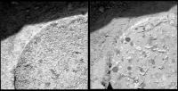
Well, with Oppy on solid ground now I think we can say she has officially arrived at the Etched terrain.
On a side note, is it my imagination, or is the dust in the air clearing a lot the past few days? I haven't seen a shot this clear in ages...or perhaps this etched terrain is on slightly higher ground than the surround sea of dunes?
http://marsrovers.jpl.nasa.gov/gallery/all/1/n/543/1N176396686EFF5847P0607L0M1.JPG
Posted by: MahFL Aug 4 2005, 01:22 PM
Oppy should be able to traverse more quickly over this rocky ground. Is Victoria peeking up from the horizon ?
Posted by: Tesheiner Aug 4 2005, 01:30 PM
> Oppy should be able to traverse more quickly over this rocky ground.
Yes, but see that there are more sandy terrain until we reach Erebus.
> Is Victoria peeking up from the horizon ?
As already said before, Victoria is below the current line of sight.
It won't be visible until a point more or less at the half-way between Erebus and Victoria.
Posted by: RNeuhaus Aug 4 2005, 02:55 PM
I see that around there, etched terrain, there are more outcrop than the north way from the Endurance crater. The question is why it is so?
1) The land is higher than the north?
2) This zone has stronger or more often winds?
3) The water started to flow first around Erebus?
4) "By that time there were more Roman cart traffic?
Rodolfo.
Posted by: Richard Trigaux Aug 5 2005, 09:50 AM
With my opinion Erebus, like Bonneville, is not a major scientific target, as it is filled with sand and probably dangerous to try to descend in. So it is possible that they even not attempt to get closer, taking a short cut through etched terrain toward Victoria. The later is anyway an important target, at it may exhibits a much thicker layer of evaporites than Endurance. So the situation is similar to Endurance, but there may be no way to descend into Victoria, or no way to get out.
At last we are now sure that etched terrain is exposed layers of evaporites.
But with RNeuhaus I wonder why terrains are so different, while sharing the same geological properties (20-40cms of sand on evaporites):
-Near Endurance, flat terrain with only small ripples
-Near Viking, larger dunes
-An now round Victoria-Erebus, dunes separated by troughs hollowed down to the evaporite layer.
Would it be wind channels on Mars? And why?
Maybe the ration sand/blueberries is responsible for the dunes variations? or some component of the evaporites?
Posted by: Bill Harris Aug 5 2005, 10:47 AM
Erebus is potentially an important target since it is a deep excavation in the Evaporite sequence which has much of the ejecta weathered and eroded away. We are essentially left with a big road cut: although the interior of Erebus is sand-filled, the walls are visible With Victoria, it is newer and fresher and has a huge ejecta blanket obscuring details.
IMO, a significant target here ought to the "dark basal unit" (D1, D2 and those &%$# dark angular pieces we see) since it is something we didn't see at Endurance.
--Bill
Posted by: TheChemist Aug 5 2005, 11:44 AM
Let's see what the science instruments tell us about the etched terrain outcrop.
It seems the weekend will be spent there :
Posted by: Cugel Aug 5 2005, 11:03 PM
IMO, a significant target here ought to the "dark basal unit" (D1, D2 and those &%$# dark angular pieces we see) since it is something we didn't see at Endurance.
--Bill

Bill,
Looking at the map there might be some pretty hefty dune fields between Oppy and those targets (D1, D2). Driving through Erebus itself seems totally out of the question, so how likely is it that we can reach these outcrops? On this side of the crater there doesn't seem to be so much interesting stuff, does it? And how much topography does the etched terrain actually offer? Between this location and Victoria it seems to be as flat as a pancake. Maybe this is enough reason to put the pettle to the metal and try to reach Victoria ASAP?
Posted by: Bill Harris Aug 6 2005, 01:34 AM
There may be dune fields, but there is also the evaporite pavement along the north side of Erebus, which might be easily travelled. We'll see what it looks like once we get to Erebus.
--Bill
Posted by: Richard Trigaux Aug 6 2005, 08:22 AM
Bill,
the evaporite pavement near Erebus is already known, and there is no hope to go deeper in Erebus than in Endurance, so I think it is why Erebus is not an important science target.
On the other hand, there is this pavement you mention along the norh side of Erebus, that may be easily traversed. (At rough guess, as it seems that there are many "Anatolia type" pits and cracks in the etched terrain). If they choose this path, they could spare some days to have a look into Erebus.
What makes Victoria very interesting, is that it is much deeper than Endurance, and so deeper layers of evaporite may be exposed, eventually underlying layers of another nature (which seem black in comparison with the evaporites). So They will certainly try to descend into Victoria, even if they could never get out of it. A similar bargain was made when discussing about descending into Endurance.
Posted by: dilo Aug 6 2005, 02:25 PM
New PanCam images!
This is the full-res stitch from L2+L7 filters:
|
|
Posted by: Vladimorka Aug 6 2005, 04:13 PM
And we have a RAT - the first RAT in many months!!!
http://marsrovers.jpl.nasa.gov/gallery/all/1/p/545/1P176575886ESF5847P2573R1M1.JPG
Posted by: DEChengst Aug 6 2005, 04:48 PM
You wouldn't need to go into Victoria crater to examine the deeper layers. After all Victoria is a crater so you could examine the ejecta to measure the same stuff. Ofcourse this wouldn't give you direct information about the depth the stuff came from, but miniTES might help there. Also I think it wouldn't be a big deal if you could get in, but couldn't get out. I guess that other stuff that's different enough from what we've already seen to make it scientifically worthwhile, is probably way too far away to reach it. So going into Victoria and dying there may be very well the right choice.
Posted by: Jeff7 Aug 6 2005, 05:16 PM
This is the full-res stitch from L2+L7 filters:
|
|
Yikes, some of those dunes look pretty darn big.
Loads of exposed rock all over the place here too. Hopefully the wind will have granted us safe passage between the dunes. I too would like to see Victoria. I wonder how many Pancam shots it'd take to get a rim-based panorama of that.
Posted by: um3k Aug 6 2005, 10:57 PM
Loads of exposed rock all over the place here too. Hopefully the wind will have granted us safe passage between the dunes. I too would like to see Victoria. I wonder how many Pancam shots it'd take to get a rim-based panorama of that.
The same number of shots that it would take to get a panorama of anything else.

Posted by: deglr6328 Aug 6 2005, 11:15 PM
http://marsrovers.jpl.nasa.gov/gallery/all/1/p/545/1P176575886ESF5847P2573R1M1.JPG
Wow it looks really deep!
Posted by: Jeff7 Aug 7 2005, 01:36 AM
I thought it had some kind of higher res mode. I guess that's that super-res technique that I'm thinking of. Hm.
Stinks that the rovers haven't got zoom lenses. But I suppose that's just one more thing that could fail.
Posted by: babakm Aug 7 2005, 03:45 PM
What previously appeared like outcrops on the South and West sides of Erebus are looking more and more like large dunes on the flat "pavement that" Oppy is standing on right now. Certainly deserves a closer look, but not as exciting as I originally thought.
Posted by: Sunspot Aug 10 2005, 11:58 PM
On the move again:
http://marsrovers.jpl.nasa.gov/gallery/all/1/r/549/1R176930626EFF58CXP1390R0M1.HTML
Posted by: Bill Harris Aug 11 2005, 02:24 AM
Whew. Look at the Sol 549 MI's of the RAT hole done on Sol 546.
This is super-weird.
--Bill
Posted by: ElkGroveDan Aug 11 2005, 02:36 AM
This is super-weird.
--Bill
OK Bill I'm looking. Help me out here. I always enjoy a good weirding-out at the end of the day, but I'm not seeing it.
Is this the MI series you are talking about?
http://marsrovers.jpl.nasa.gov/gallery/all/1/m/549/1M176920049EFF5847P2936M2M1.JPG
Posted by: Decepticon Aug 11 2005, 02:48 AM
I wish they would clean out they holes they just finished Rating.
Wouldn't it make sense to see what you just bored out!?
Posted by: deglr6328 Aug 11 2005, 02:56 AM
I don't think they CAN clean it out. The stuff is so soft and crumbly its like boring a hole in a cake and then trying to brush the crumbs out of the hole. The wire brush itself is stiff enough to keep dislodging more material from the bottom of the hole!  And if the hole is nearly flat horizontal there's nowhere for them to fall after they have been brushed "away".
Posted by: mike Aug 11 2005, 05:29 AM
It's not necessarily all that soft.. if it were consistently that soft, they could just use the brush and ditch the RAT altogether. I suppose it's possible that every rock has a thin hard outer shell covering a largely soft interior, but that seems unlikely to me.
They could at least try to brush one of them. It is odd that they haven't ever tried.
Posted by: deglr6328 Aug 11 2005, 05:34 AM
Oo-ee, gooey, rich and chewy inside...
Golden, flaky, tender cakey outside..
Wrap the inside in the outside......... 
Sorry, had to.
Posted by: dvandorn Aug 11 2005, 05:41 AM
Now, there's an interesting new perspective on Areology -- that Mars is one giant Fig Newton!
And who knows -- maybe there are chocolate fudge volcanoes on Venus...
-the other Doug
Posted by: dilo Aug 11 2005, 05:58 AM
Now it seems she fully reached the highway!...
http://marsrovers.jpl.nasa.gov/gallery/all/1/r/549/1R176930626EFF58CXP1390R0M1.JPG
Posted by: Tesheiner Aug 11 2005, 07:45 AM
Near this point:

|
(http://marsrovers.jpl.nasa.gov/gallery/all/1/n/543/1N176396089EFF5847P0703L0M1.JPG navcam picture from sol 543)
Edited: And if previous estimations for sol 543 position were accurate, we are about to leave the highway for another 100m of "desert crossing" until standing again on rocky terrain.
Posted by: Bill Harris Aug 11 2005, 08:45 AM
Sol 546 image of RAT: clean, with lots of interesting details seen.
Sol 549 image of RAT: cuttings blown into hole.
Unless I'm looking at a second RAT hole.
Data point: it is especially windy at Meridiani.
--Bill
Posted by: Sunspot Aug 11 2005, 09:08 AM
They might have used the RAT again on the same hole to make it deeper.
Posted by: TheChemist Aug 11 2005, 09:39 AM
It does not look deeper though ...
Gee, two sols of images missing (547, 548), and a RAT hole covered in sand.
Do you think we had a major "cleaning event" that was more fierce than the previous ones ?
Posted by: Bill Harris Aug 11 2005, 12:28 PM
And if you look closely you can see some of the RATted blueberries faintly through the blown dust, so I think this is the same hole.
Given the dustdevil activity at Gusev, I'd suspect similar aeolian activity at Meridiani. We may see fewer (or no) DDs here because Meridiani is less dusty, being paved in blueberries. Recall the rapid changes on the rover tracks at Purgatory-- within a few days, the underlying dust was streaking away from the disturbed areas.
--Bill
PS-- Oppy did take a series of solar panel MI's, so we may know if there was a cleaning event soon. And we can check the solar panel output as it has been decreasing.
Posted by: djellison Aug 11 2005, 12:48 PM
It's the same hole for sure - but wow - lot of dust dumped in there
One would hope that if the nearby dust was blown INTO the hole - then dust would also be blown OFF the rover 
Doug
Posted by: garybeau Aug 11 2005, 10:43 PM
It looks to me like they went back in with the brush. Many of the features looked pitted rather than covered with dust.
|
Posted by: mike Aug 12 2005, 12:59 AM
Yeah, in hindsight NASA has surely brushed at least one RAT hole.. So ignore what I wrote about whatever, blah blah
Posted by: djellison Aug 12 2005, 06:48 AM
Back in with a brush and made it filthy? I dont think so. The clean rat hole is before the dusty rat hole chronologically. Dust deposition makes a lot more sense to me
Doug
Posted by: Bob Shaw Aug 12 2005, 09:53 AM
Doug
Doug:
It looks less like dust deposition to me than the matrix breaking up, with the smooth surface disintegrating into clumps. At the risk of setting another wild goose chase off, I wonder whether static charges could have built up during the RATting which made the very fine particles dance about. I have yet to be convinced about macro-scale aoelian effects (microscopic dust layers, fine - it's just the big chaps that I have my doubts about!).
Bob Shaw
Posted by: Bill Harris Aug 12 2005, 10:44 AM
I'll have to stand over in the confused side of the aisle, too. Initially I saw this and thought "cuttings blown in", but I swear, the surface does look pitted and eroded. Thsi may be an optical illusion, and I'm waiting for more MI's.
--Bill 
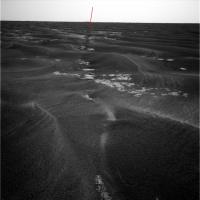
Posted by: djellison Aug 13 2005, 06:27 PM
Strange crack in the terrain -
http://marsrovers.jpl.nasa.gov/gallery/all/1/n/549/1N176927970EFF58B1P1700L0M1.JPG
Doug
Posted by: jvandriel Aug 13 2005, 06:47 PM
A 360 degree panoramic view of Opportunity in the middle of the bedrock.
Taken with the L Navcam on Sol 550
jvandriel
|
|
Posted by: dilo Aug 13 2005, 08:27 PM
Yes Doug, you can see it also in Sol550 jvandriel Panorama (Oppy traversed it) and in previous Sols I noticed other linear structures partially hidden, eventually related to this:
|

|
My idea is that there is a large "macro" crack system connecting many outcrops, and running below the dunes (we should think to a unique cracked pavement partially covered by dunes, in fact
 ...
... They must be deep too and I strongly suspect they are the cause of "minicraters", as suggested by this image of aligned collapsed sand holes on the side of that dune!

|
(I never trusted to minicrater explaination...)
Posted by: Bob Shaw Aug 13 2005, 09:01 PM
Dilo:
Very interesting - a sort of limestone pavement, Karst style topography below the dunes... ...hmmm.
And I never really bought the mini craters, either!
Bob Shaw
Posted by: Myran Aug 13 2005, 09:18 PM
There sure are a crack there djellison, and agreeing with dilo, I was never comfortable with the idea of miniature impact craters.
Opportunity did pass a series of sinkholes on the way to Endurance suggesting there are a karst bedrock below. The minicraters might be paritialy filled sinkholes and the cracked lines like the one djellison pointed out could very well have come from underneath.
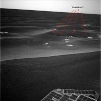
Posted by: dilo Aug 13 2005, 11:32 PM
Starting from Jvandriel last Pano, I made a magnified vertical projection (5 cm/pixel) in order to better identify the macro-cracks:
|
Here I tried to identify them, with possible (not sure) connections:
|
It seems they form an (approximately) orthogonal grid, with one of the two directions going toward Erebus...
Posted by: tty Aug 14 2005, 06:04 PM
Seems reasonable if the cracking is connected to the Erebus impact. Intuitionally I would expect cracking around an impact to be either radial (if caused by the uplift of the crater rim) or concentric (if caused by the overpressure/underpressure couplet of the expanding shock-wave).
tty
Posted by: Bill Harris Aug 14 2005, 09:10 PM
Not surprising or unusual. A strain ellipsoid shows that a deformation will produce a set of orthogonal fractures. Question is, what was the stress that produced this strain?
The anatolia-Karst lineaments are interesting because they have the appearance of solution cavities along a joint system. Interesting, because you need liquid water in quantity to dissolve the evaporite.
--Bill
Posted by: djellison Aug 14 2005, 09:34 PM
Doug
Doug
Posted by: Bob Shaw Aug 14 2005, 09:41 PM
Doug
Doug:
Well, I suppose we *did* see those un-enhanced Dust Devils...
Bob Shaw
Posted by: TheChemist Aug 15 2005, 12:47 PM
Any information for the total lack of images from Sol 547-548 ?
Posted by: djellison Aug 15 2005, 01:00 PM
I guess we'll see with the next update at JPL - bad uplink perhaps - low priority imagery - who knows.
Doug
Posted by: Sunspot Aug 15 2005, 01:05 PM
Doug
The odd thing is, images from Opportunity are updated daily, Spirit seems to get left behind.
Posted by: RNeuhaus Aug 15 2005, 02:06 PM
Opportunity did pass a series of sinkholes on the way to Endurance suggesting there are a karst bedrock below. The minicraters might be paritialy filled sinkholes and the cracked lines like the one djellison pointed out could very well have come from underneath.
The outcrop surface looks like that this was a bottom of a lake which was drained and left dry it for long a time, the land start to crack due to dry land and later it is covered by sands. One interesting is that there is a direction of crack, It seems that the water has flown on a constant direction during its draining process.
About minicraters, I don't think so. Under the minicraters, must have some kind of big fisures where the sand sinks.
Rodolfo.
Posted by: Burmese Aug 15 2005, 02:14 PM
Well run on over to the Spirit pages! They got stuff up thru Sol 574 now. Hills, plains, dust devils, movement, the works.
Posted by: jvandriel Aug 15 2005, 08:54 PM
A panoramic view on Sol 553.
Taken with the L2 Pancam.
jvandriel
|
|
Posted by: Tesheiner Aug 16 2005, 10:39 AM
Mmm, interesting...
Usually they take a set of pancam pics in the direction they plan the next movement. However, all pics taken on sol 553 are to the left (east) --- looking to the Erebus Highway --- instead of straight-ahead (south).
Let's see what happens.
Posted by: dilo Aug 16 2005, 08:06 PM
Jvandriel, I combined the last two panoramas you made in this vertical projection (10cm/pixel):

|
From comparison with satellite image, it seems that bright, central part of highway is hidden, probably due to high dunes and depressed level of outcrops making it...

|
Posted by: Tesheiner Aug 17 2005, 06:29 AM
Came to the same conclusion too.
Even outcrops that were fully seen on previous panoramas are now partially hidden due to the nearby dunes.
Posted by: jvandriel Aug 17 2005, 11:03 AM
Dilo,
great combos.
I have no problems with using my pano,s.
The pictures are from JPL and the American taxpayer.
jvandriel
Posted by: Tesheiner Aug 19 2005, 09:34 AM
An http://marsrovers.jpl.nasa.gov/mission/status.html#opportunityon MER website:
OPPORTUNITY UPDATE: Opportunity Entering Cobble Field - sol 544-551,
July 18, 2005
Opportunity had a busy week! The rover has been using the rock abrasion tool ...
Edited: July 18?
Edited again: ... and I think that I have the answer to this:
Usually they take a set of pancam pics in the direction they plan the next movement. However, all pics taken on sol 553 are to the left (east) --- looking to the Erebus Highway --- instead of straight-ahead (south).
Let's see what happens.
"The planning team wants to ensure that Opportunity has enough flash memory for next week's operations since the plan calls for a continuation of the drive toward "Erebus." The general consensus is that the rover will take the easterly route to the Erebus highway. This route is longer by about 100 meters (328 feet), but should result in much more access to outcrop during the drive. The outcrop is attractive both for rover footing and for science targeting."
Posted by: Jeff7 Aug 20 2005, 05:45 AM
Can we like, launch a 4GB memory stick to Mars? Those things are getting so cheap now, just send it there, plug it into the rover's USB port, and it's good to go. Right?
Posted by: tedstryk Aug 20 2005, 12:47 PM
Of course, there would have to be some way to get the data back to Earth!
Posted by: ilbasso Aug 20 2005, 12:52 PM
I volunteer to go pick it up! Can I pick up anything for anyone while I"m in the neighborhood?
Posted by: ElkGroveDan Aug 20 2005, 03:56 PM
How about bringing me back Sojourner? It would look great on my living room coffee table.
Posted by: mhoward Aug 20 2005, 04:07 PM
Here's a great view back the way we came on Sol 553. Endurance Crater and the heatshield can easily be seen (amazingly).
http://marsrovers.jpl.nasa.gov/gallery/all/1/p/553/1P177277286ESF58D4P2690L6M1.JPG
http://midnightmarsbrowser.blogspot.com/2005/08/opportunity-sol-553-endurance-on.html
Posted by: glennwsmith Aug 21 2005, 04:16 AM
mhoward: That IS amazing -- I didn't realize the images had eoungh resolution that we could enlarge a portion and still see the heatshield (albeit as a speck) and Endurance Crater. Perhaps OPPY was on a slight rise when it took the photo?
Posted by: mhoward Aug 21 2005, 05:26 AM
Looking around the panorama, I believe we are on a very gradual rise as we approach Erebus, which is probably why we can see Endurance again. I think I read or heard something to that effect in one of the mission updates somewhere too, but I can't find it at the moment.
Posted by: Tman Aug 21 2005, 07:49 AM
Yea they released sometime this grafic in a PDF: http://www.greuti.ch/oppy/profile_oppys_terrain.jpg
It's interesting in this Pancam pic around Endurance one see the same brighter plane as in these east views. So I guess now we can say thats probably due to the lack of dunes.
Posted by: Burmese Aug 22 2005, 12:46 PM
How did they get such a detailed profile? There are dips up ahead that Oppy cannot image yet. Mars Express perhaps?
Posted by: djellison Aug 22 2005, 12:51 PM
MOLA could do something like that - 250m sampling roughly
Doug
Posted by: Tesheiner Aug 23 2005, 01:19 PM
With Spirit now near/at the summit, the news about what is happening on the other side of Mars are left on a secondary plane...
Oppy drove (backwards) on sol 561 and another drive is planned for today. She may be moving now or in a few hours.
http://nasa.exploratorium.edu/mars/opportunity/forward_hazcam/2005-08-22/1F177986534EFF58DLP1212L0M1.JPG
From http://marswatch.astro.cornell.edu/merweb/merweb.pl:
Expected EDRs by sequence number and image type:
Sol Seq.Ver ETH ESF EDN EFF ERP Tot Description
--- -------- --- --- --- --- --- ---- -----------
562 p1205.03 2 0 0 2 0 4 front_haz_penultimate_0.5_bpp_pri18
562 p1214.05 2 0 0 2 0 4 front_haz_ultimate_4bpp_pri15
562 p1311.05 2 0 0 2 0 4 rear_haz_ultimate_1_bpp_pri24
562 p1875.00 10 0 0 10 0 20 navcam_5x1_az_90_3_bpp
562 p1876.00 10 0 0 10 0 20 navcam_5x1_az_270_1_bpp
562 p1877.00 20 0 0 20 0 40 navcam_360_start_LVL_AZ_18_1_bpp
562 p1960.00 4 0 0 4 0 8 navcam_lower_2x1_RVR_AZ_0_2_bpp
562 p2102.13 3 0 3 0 1 7 pancam_isc_voc_cal_L267
562 p2104.10 3 0 3 0 1 7 pancam_mtes_cal_target_L267
562 p2354.06 10 0 0 10 2 22 pancam_drive_direction_2bpp_L7R1
Posted by: avkillick Aug 23 2005, 03:06 PM
I'm amazed at how clean those wheels are. Is this the same Oppy that was half buried in a sandy quagmire a few months ago?!
Posted by: dot.dk Aug 23 2005, 03:24 PM
You know, the cleaning service on Mars is top notch
Posted by: mike Aug 23 2005, 03:28 PM
It isn't like what I'd expect on Earth.. I imagine the lack of moisture on Mars makes everything easily just fall off and/or blow away. Quite counter-intuitive.
Posted by: Phil Stooke Aug 23 2005, 07:48 PM
Right, no moisture, no sticking. And yet some folks were swearing that the soil was muddy! But mud behaves quite differently from dry powder. I took a lot of criticism in another place for daring to say the soil was dry. Oh well, that's life!
Phil
Posted by: djellison Aug 23 2005, 07:58 PM
I know where and what you mean Phil "There was frost - it must be wet"

This stuff is like talc or cement dust - dry but strangely adhesive at time.
Doug
Posted by: mike Aug 23 2005, 09:30 PM
There have been some images where the upturned dust/dirt/whatever in the tracks of one rover or another (Spirit?) looked suspiciously 'gooey'. And I suppose it's possible that water could liquify every once in a great while. Alternately, I suppose there could be the tiniest amount of water present everywhere, tiniest as in very, very, very tiny (so tiny as to be meaningless, except insofar as the amount is not 'actually' zero, except that it might as well be, but IT'S NOT).
In general, though, Mars is clearly quite dry, unlike as in that 1960s-era film I saw in science class, where the floating cartoon character said there could be life on Mars and flowers sprouted everywhere.. the cartoon character was wearing glasses, though. That's gotta count for something.. maybe the flowers only sprout every once in a while.
Posted by: Marslauncher Aug 24 2005, 12:10 PM
http://qt.exploratorium.edu/mars/opportunity/pancam/2005-08-23/1P178078462EFF5900P2354R1M1.JPG
Could this be we are coming up to a ridge?? where the terrain finally starts going down hill.?
(or could we be looking into the dip of Erebus?) It looks a lot larger than Erebus
I have cropped and increased in size a little the above picture to enhance it a little
|
|
Posted by: Bill Harris Aug 24 2005, 03:55 PM
Oppy has been driving up a topographic high for a while and we're starting to be able to see beyond this "Sea of Dunes" to the (less dune-y) plain to the East and also back to Endurance and the plains to the North. After she gets past Erebus/TerraNova she should "crest the hill" and the Victoria rim may become visible.
--Bill
Posted by: jvandriel Aug 27 2005, 02:17 PM
A 360 degree panoramic view of Opportunity.
Taken on Sol 562 with the L0 Navcam
jvandriel
|
|
Posted by: SigurRosFan Aug 29 2005, 10:16 AM
Nice panorama! That's my version of your panoramic view.
http://xs44.xs.to/pics/05351/Opportunity_Sol_550_Rover.jpg (287.5 KB)
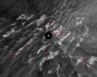
Posted by: Phil Stooke Aug 29 2005, 01:09 PM
I have made another version of jvandriel's new pan, sol 562:

|
I did two things to it: first I removed most of the shading between frames, and the azimuthal shading variation, by using a simple Photoshop trick. It's not perfect, but it works with other streaky images like Lunar Orbiter and some MOC raw images.
1. duplicate the image layer. 2. shrink it to one pixel high. 3. expand back to full image height. 4. invert the layer (make it a negative). 5. Make it 50% transparent. 6. flatten and enhance contrast.
This just averages out the shading variations and removes them.
Then, of course, I made it circular using 'polar coordinates' and the foreground-compression routine I described earlier.
Incidentally, with what I believe people used to call 'a bit of a mind-flip' you can see this area, not as dunes (ripples) with patches of rock between them, but as a continuous rock surface with dunes superimposed on it. I imagine that as we get into the bigger etched terrain exposures that will be increasingly apparent.
Phil
Posted by: RNeuhaus Aug 29 2005, 03:45 PM
|
|
I did two things to it: first I removed most of ... ...
Phil
Incredible kitchen recital: Photoshop Sphere!.
The image is superb for many purposes inclusive it is a perfect picture for remote driving. Rodolfo
Posted by: Bill Harris Aug 30 2005, 12:56 AM
Oppy does not appear to be dead-- she's transferring data and is doing a lot of downsampled Navcams, evidently plotting a new route on the Erebus Highway onramp. No more word (AFAIK) on the 'puter reboot.
One odd series of images-- she seems to have done some back-and-forth-and-over driving across a dune crest, does not seem to be the usual post-drive uplink positioning maneuver:
http://qt.exploratorium.edu/mars/opportunity/navcam/2005-08-29/1N173547490EDN55WGF0006L0M1.JPG
I'm looking forward to getting on the wide bedrock exposures of the Highway...
--Bill
Posted by: jamescanvin Aug 30 2005, 01:39 AM
http://qt.exploratorium.edu/mars/opportunity/navcam/2005-08-29/1N173547490EDN55WGF0006L0M1.JPG
That's an old image from Soll 511, just after getting out of Purgatory Dune.
James
Posted by: Bill Harris Aug 30 2005, 05:50 AM
Ah! That's right, I remember that maneuver. She must be flushing her flash memory.
--Bill
Posted by: peter59 Aug 30 2005, 11:17 AM
Drive on sol 569 planned. Opportunity is OK, I hope.
Expected EDRs by sequence number and image type:
Sol Seq.Ver ETH ESF EDN EFF ERP Tot Description
--- -------- --- --- --- --- --- ---- -----------
569 p1205.03 2 0 0 2 0 4 front_haz_penultimate_0.5_bpp_pri18
569 p1214.05 2 0 0 2 0 4 front_haz_ultimate_4bpp_pri15
569 p1235.04 2 0 0 2 0 4 front_hazcam_stumble_0.5_bpp_pri_56
569 p1311.06 2 0 0 2 0 4 rear_haz_ultimate_1_bpp_crit18
569 p1335.03 2 0 0 2 0 4 rear_hazcam_stumble_0.5_bpp_pri_56
569 p1916.05 12 0 0 12 0 24 navcam_6x1_lvlaz_103_3bpp_crit
569 p2111.05 13 13 0 0 2 28 pancam_cal_targ_L234567Rall
569 p2357.06 10 0 0 10 2 22 pancam_drv_dir_5x1_L2R2
569 p2530.10 13 0 0 13 2 28 pancam_skidmark_L234567Rall
569 p2531.10 13 13 0 0 2 28 pancam_wreckage_L234567Rall
569 p2599.09 5 0 0 5 2 12 pancam_ripple_fender_L257R12
Posted by: Sunspot Aug 30 2005, 12:45 PM
....stumble, skidmark, wreckage? lol... what's that all about?
Posted by: Tesheiner Aug 30 2005, 01:09 PM
Different features seen on the bedrock, I would say.
They used "funny" names also some days ago (sol 565, 566?).
Posted by: djellison Aug 30 2005, 01:14 PM
'Skidmark' is probably the point at which Oppy came to a halt with that reset
Doug
Posted by: ilbasso Aug 30 2005, 07:46 PM
"Skidmark" could also be used to describe what was in our some of our shorts after Oppy abruptly came to a halt yet again...
Posted by: Myran Aug 30 2005, 07:59 PM
Seems the engineers consider that some problem with the miniTES that was responsible.
'Engineers believe Opportunity is in good health, although the team will refrain from using the miniature thermal emission spectrometer pending further analysis of the software reset.'
Posted by: mhoward Aug 31 2005, 01:00 AM
Nice view off onto the plains: http://www.flickr.com/photo_zoom.gne?id=38738058&size=l
Posted by: Bill Harris Aug 31 2005, 08:52 AM
And it seems that the dark "un-dune-y" area on the horizon is getting broader, so we are making progress. And I think I can make out the Erebus Highway ahead of us.
--Bill
Posted by: Tesheiner Aug 31 2005, 03:34 PM
Yes, but see that Oppy still has to dodge a lot dunes on the way to the Highway.
Actually, she is now facing NE (check the pancam images on mhoward's post) so it seems that the MER team are planning some zig-zag.
This is what I think is a possible path to the highway, superimposed on sol 569 navcam panorama (heavily compressed).
|
|
Powered by Invision Power Board (http://www.invisionboard.com)
© Invision Power Services (http://www.invisionpower.com)