Printable Version of Topic
Click here to view this topic in its original format
Unmanned Spaceflight.com _ Opportunity _ Eagle Crater Map
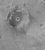
Posted by: Phil Stooke Nov 26 2005, 04:17 AM
This is what delayed my Anatolia map. It shows what is possible with these panoramas, I note that this is easier in very low relief areas...
This is not perfect, and in particular the crater's outer slope was not imaged completely and is distorted here. There are other distortions too, including a sort of fish-eye effect which makes Eagle bigger than it should be and distant areas smaller. The hard part is just making the image in the first place, but once you have it, it can always be rubber-sheeted to fit better positional control.
Eventually, this map (or an improved version) and similar maps of other areas where quite a lot happened, will form the basis for an atlas-style presentation of the whole mission.
Phil
|
Posted by: jamescanvin Nov 26 2005, 04:51 AM
Now that is nice! 
Great work Phil.
Posted by: slinted Nov 26 2005, 05:10 AM
This is a great looking map Phil. I've been pondering of this sort of thing since the misisons began, and you've nailed it. I'm trying something similar in the Paso Robles area for Spirit. Are you projecting onto a terrain model, using images from several different viewpoints? If so, do you overlap the images, or is there some sort of blending to control which image shows through at any given point?
Since Eagle Crater, and all the other interesting terrain features for that matter, are themselves irregularly shaped objects, I guess I shouldn't be too surprised how well you've done with this problem. Very nice job!
Posted by: Phil Stooke Nov 26 2005, 05:16 AM
I'm not using a real terrain model. This is not well controlled. But I am trying to be careful to make sections of the mosaic match each other properly. This could be rectified using a good terrain model, later on if they become available. At the moment my map is more art than science. But all cartography is a mix of the two.
I'd be very interested to see any other things people do like this.
Phil
Posted by: Bill Harris Nov 26 2005, 08:51 AM
Very good, Phil. I'll be looking forward to future releases of this type of mapping.
--Bill
Posted by: Tman Nov 26 2005, 09:03 AM
That's great Phil!
I'm especially fascinated about the visible track of the airbag. It's clearly visible where it runs
Now to me, it seems it was a "hole hanger" 
Posted by: Reckless Nov 26 2005, 10:57 AM
Hi Phil
Great map quite a hole hanger indeed, in fact to me it looks like the lander in it's airbags leaned back a little before rolling into Eagle crater!
Roy F
aka Reckless
Posted by: edstrick Nov 26 2005, 10:59 AM
You can also see "bounce" rock where it was hit by airbags SE of the crater.
Posted by: Nirgal Nov 26 2005, 11:34 AM
WOW, that's awsome, Phil !
unbelievable what your're able to make out of those panoramas
Posted by: dilo Nov 26 2005, 11:54 AM
Congratulations, Phil!
If you need an helping hand for the atlas presentations, I'm here! 
BTW, can someone indicate an existing 3D/elevation map of Eagle crater? this would allow to correct all distorsions Phil is talking about! (otherwise, we need a volunteer armed wit patience and Parallax calculator...  )
)
Posted by: tedstryk Nov 26 2005, 04:09 PM
If you need an helping hand for the atlas presentations, I'm here!
BTW, can someone indicate an existing 3D/elevation map of Eagle crater? this would allow to correct all distorsions Phil is talking about! (otherwise, we need a volunteer armed wit patience and Parallax calculator...
)
That is an amazing projection!
Posted by: CosmicRocker Nov 26 2005, 07:07 PM
Bravo, Phil. Most of the things we try to do with the raw images will have some inherent errors, but that does not prevent the work products from being useful. That's a keeper, and I am saving a copy for future reference.
Thanks.
Posted by: RNeuhaus Nov 26 2005, 08:25 PM
Very good Phil. You has become an polar mapping expert. The picture is very nostalgic since it is the birthplace of Oppy. A very important picture.
Rodolfo
Posted by: MizarKey Nov 28 2005, 08:47 PM
Great work Phil.
With this kind of view it's easy to imagine that if Oppy had rolled the other way and not into the crater, they might not have taken it down into the crater. It would have taken longer to get the 'blueberry' images. I imagine they would have spent a lot more time at Fram before heading to Endurance. I don't think they would have spent much time at Eagle though.
On to Victoria!
Eric P / MizarKey
Powered by Invision Power Board (http://www.invisionboard.com)
© Invision Power Services (http://www.invisionpower.com)