Printable Version of Topic
Click here to view this topic in its original format
Unmanned Spaceflight.com _ Opportunity _ Bottomless Bay
Posted by: Tesheiner Dec 3 2006, 07:43 AM
Time for a new tread.
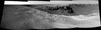
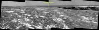
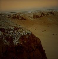
Bottomless Bay is on sight on these fresh sol 1016 pics!
http://qt.exploratorium.edu/mars/opportunity/navcam/2006-12-02/
Edited: Added this quick & dirty mosaic.
|
Posted by: jamescanvin Dec 3 2006, 07:51 AM
Yup. Great view across Bottomless Bay to Cape B1. 

|
|
James
Posted by: Tesheiner Dec 3 2006, 07:55 AM
Opps, you beat me with the panorama.
BTW, has Cape B1 an official name?
Posted by: jamescanvin Dec 3 2006, 08:04 AM
I'm sure it does, but I don't think we know it yet. A sequence name on the tracking site will probably tell us in the next day or so (unless and insider wants to chip in  )
)
James
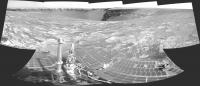
Posted by: jvandriel Dec 3 2006, 01:15 PM
Added one image. 
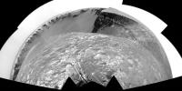
The L0 Navcam panoramic view on Sol 1016.
jvandriel
|
|
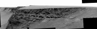
Posted by: Phil Stooke Dec 3 2006, 02:01 PM
Here's a polar version of jvandriel's half-pan:

|
Phil
Posted by: Phil Stooke Dec 3 2006, 04:09 PM
Here is the next cape, with shadows brightened a bit so see what lies in them. Not very exciting yet - pancams will be better.
Phil

|
Posted by: mhoward Dec 3 2006, 06:22 PM
http://flickr.com/photos/marscat/313070814/
Posted by: Nirgal Dec 3 2006, 08:49 PM

here is a quick colorization as a foretaste of the pancams

|
(don't have the time at the moment to do the whole pan, though ....)
Posted by: Oersted Dec 4 2006, 08:30 AM
Phil
How quickly we have gotten used to the views at Victoria Crater...
Posted by: jamescanvin Dec 5 2006, 11:23 PM
Well I was wrong, SS said in his Planetary Soc. interview that it hadn't been named and in the tracking site schedule for tosol (1019) lists the observation as just:
Posted by: jamescanvin Dec 6 2006, 11:08 AM
Oh wow! 

|
EDIT: Replaced with a more accurate projection.
James
Posted by: MarkL Dec 6 2006, 12:24 PM
The views keep getting better. Thanks James. Again, we're seeing very clear striation on these wind scoured rock faces. They are also incredibly smooth, like they've been sandblasted over eons by a very steady and patient wind.
Posted by: Tesheiner Dec 6 2006, 05:20 PM
Given the planned sequences for sol 1019 I initially thought it was driving day. It wasn't.
Agree 100%!
Posted by: hendric Dec 6 2006, 05:28 PM
James
Did anyone else notice this little bit of Martian Graffiti?

|
Translation:
Earthlings drool, Martians rule!
Posted by: MahFL Dec 6 2006, 05:43 PM
You'd have to have bad eyesight to miss it, it jumps out and says "LOOK HERE"......
Posted by: Gray Dec 6 2006, 05:51 PM
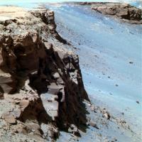
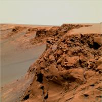
I'll add a few off-the-cuff observations and comments. It looks as if the breccia layer is a little bit thinner here. Perhaps the rate of wind abraion is a bit greater here; or was less breccia deposited?
The lower layer looks as if it still contains large cross-beds. It's not an astounding observation, but it's worthy to note that we're able to trace what is apparently the same layer across two or three bays.
There is some evidence of relatively recent erosion in the form of a rubble pile that rises high up along the middle part of the cliff. It is associated with a distinct cleft in the cliff. Again, not astounding, but it suggests that mass wasting is an on-going process.
By the way those are fantastic images. Thanks to all.
Posted by: mhoward Dec 6 2006, 07:09 PM
90 degree perspective view northeast, just for perspective...
http://www.flickr.com/photo_zoom.gne?id=315862401&size=l
Posted by: CosmicRocker Dec 7 2006, 06:15 AM
I don't recall anyone noting the look-back images of the Beacon from sol 1015. My apologies if I missed someone's post about this. They were downsampled images. I have been pretty much overwhelmed by the flood of data from Mars recently. Gigabyte sized images from HiRise of our favorite parts of the planet, both rovers moving, and now some exciting news of recent changes observed on the planet. Wow.
Some down-sampled images from sol 1015 included a look-back at the Beacon from the other side. It appears more prominent from this direction, does it not? Hand stitched, because my other software complained...

|
Posted by: jvandriel Dec 7 2006, 10:54 AM
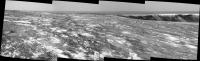
Here is the complete 360 degree panoramic view from Sol 1015.
Taken with the L1 pancam.
jvandriel
|
|
Posted by: climber Dec 7 2006, 11:52 AM
First time since we discovered it that we move AWAY from the Beacon : it will be soon on the FAR Rim
...Pool is opening again
Posted by: Floyd Dec 7 2006, 03:03 PM
Images from opportunity are a bit late showing up today 
Posted by: Martial Dec 7 2006, 03:11 PM
Taken with the L1 pancam.
jvandriel
JVandriel,
Your panoramic are always very interesting, but what's a pity they always are so tinyjava script:emoticon(':unsure:', 'smid_15')

Posted by: djellison Dec 7 2006, 03:36 PM
That was an albedo pan ( i assume tied in with the MRO HiRISE obs ) - so the frames are downsized to begin with. And I for one am glad they're small...backing up this forum has gone from a 1.2 gig operation to > 2 gig almost entirely due to the huge number of attachments that are being uploaded recently.
Doug
Posted by: chris Dec 7 2006, 04:54 PM
Doug,
You may need a HiCapacity backup device.
Chris
Posted by: djellison Dec 7 2006, 08:36 PM
HiDrive
Thing is - I'll fill it with HiSTUFF .
Posted by: Jeff7 Dec 7 2006, 10:30 PM
Images from opportunity are a bit late showing up today Odyssey's safe moded, possibly from some unrest on the sun. It should be back online in a few days.
http://www.unmannedspaceflight.com/index.php?showtopic=3567&st=0
Posted by: Nirgal Dec 8 2006, 12:03 AM
a quick false-color panorama:

|
Posted by: Stu Dec 8 2006, 12:10 AM
The usual high standard Nirgal, very pleasing to the eye indeed. Victoria - the crater that just keeps giving and giving...!
I really want a close look at "Hoy" tho... keep going Oppy, keep going...
Posted by: kungpostyle Dec 8 2006, 03:56 AM
another data pinch
http://athena.cornell.edu/news/mubss/
Posted by: jvandriel Dec 8 2006, 10:26 AM
Here is my coloured version of the L2 Pancam view
on Sol 1019.
jvandriel

|
Posted by: jvandriel Dec 8 2006, 10:33 AM
and the L2 Pancam view in the drive direction
on Sol 1019.
jvandriel

|
Posted by: jamescanvin Dec 12 2006, 06:16 AM
Since the Odyssey safe mode seems to have thrown a spanner in the works as far a images MER images are concerned, we'll have to make do with what we have. So here is the Bottomless Bay mosaic with luminosity from the full resolution L2 and colour from the L257 64x64 thumbnails.
http://www.physics.usyd.edu.au/~jcanvin/mer/index.html#B1019
James
Posted by: dilo Dec 12 2006, 07:41 AM
Excellent work, James!
I taken the freedom to sharpen the luminance channel of this mosaic, lot of details are now visible:

|
Posted by: Tesheiner Dec 12 2006, 09:47 AM
FYI, one of the pancam shots planned (and hopefully taken) on sol 1021 is named "Islas Baleares".
01021 p2438.08 6 0 0 6 1 13 pancam_islas_baleares_L257
I'm pretty sure some of you know them or have already been there.
http://en.wikipedia.org/wiki/Balearic_Islands
Posted by: imipak Dec 12 2006, 08:43 PM
Good to see the http://en.wikipedia.org/wiki/Gecko_%28layout_engine%29 looking so chilled and happy! As it happens, one of those islands hosts a popular club called "Space". I'm sure there's a moral in there somewhere...
The details of the cross-bedding emerging are fantastic. Do I remember someone (Steve Squyres? I've heard a lot of Steve lately, what with Doug's interview, the lecture, the radio programme. I'm spoiled!) mentioning cross-bedding as indicative of dunes, as opposed to running water? Or is it the case that it's consistent with both, but that festoon cross-bedding is (one indicator) that it has to be running water, as opposed to aeolian deposits? Looking at the size of the most obvious examples, I can more easily imagine wind-driven sand /dunes/ than watery sand /banks/. (And we all know what a great guide uneducated intuition is to these sorts of things..
Posted by: Floyd Dec 13 2006, 03:42 PM
Some new hazcams and navcams are down at http://qt.exploratorium.edu/mars/opportunity/
Posted by: jamescanvin Dec 14 2006, 10:27 PM
01021 p2438.08 6 0 0 6 1 13 pancam_islas_baleares_L257
I'm pretty sure these are the Islas Baleares (from the sol 1016 navcams)

|
James
Posted by: PDP8E Dec 15 2006, 01:04 AM
A story on New Scienctist about a blueberries at victoria
http://space.newscientist.com/article/dn10802-mars-rover-nears-bathtub-ring-of-blueberries.html
Steve is heavily quoted
~pdp8
Posted by: Shaka Dec 15 2006, 01:45 AM
"a bathtub-ring of blueberries"

Oh, what a tangled web we weave,
When first we practice simile.

Posted by: CosmicRocker Dec 15 2006, 07:55 AM
That's the same darn blueberry image we argued about earlier. Remember the discussion of cone-shaped berries versus spherical? SS has also used the bathtub ring analogy (I think it is a great analogy) several times previously to describe the concept that the concretions diminished in size and possibly disappeared altogether as Opportunity climbed in elevation, and probably stratigraphically, above an ancient water table.
I think it was a decent article, but it is mostly recycled information from other sources.
Posted by: Tesheiner Dec 15 2006, 09:40 AM
Thx for pointing that. They are much smaller then their terrestrial equivalents.
Posted by: fredk Dec 16 2006, 12:21 AM
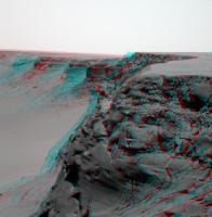
Looking across Bottomless Bay in long baseline 3D. L2 pancams from sol 1019 and 1021:

|

|
Posted by: Stu Dec 16 2006, 12:34 AM
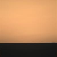
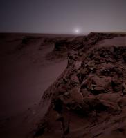
Imagined sunset at Bottomless Bay...

|
Posted by: Floyd Dec 16 2006, 04:05 PM
Stu, very nice!
Has anyone put together the complete navcam pan for 12/15 or did I just miss it in another thread?
Posted by: jvandriel Dec 16 2006, 05:54 PM
Panorama from Sol 1028. Taken with the L0 navcam.
As soon as the other images are down, I will complete
the panorama.
jvandriel
|
|
Posted by: ustrax Dec 16 2006, 06:26 PM
|
|
|
|
Everyone providing a "local" look into into Mars deserves a Xmas present...
That includes you...
Come up with your best wishes!
...And thank you!
Posted by: mhoward Dec 16 2006, 07:38 PM
Couldn't resist...
http://flickr.com/photo_zoom.gne?id=324111761&size=l
Posted by: Phil Stooke Dec 16 2006, 08:20 PM
Here is jvandriel's pan on polar form.
Phil

|
Posted by: jvandriel Dec 17 2006, 12:26 PM
Stretching Autostitch to the limit and added 1 image.
Panorama taken on Sol 1021 and 1023 with the
R0 Navcam.
jvandriel

|
Posted by: Airbag Dec 17 2006, 03:31 PM
The pano above appears to show a nice example of the http://en.wikipedia.org/wiki/Opposition_effect around the Pancam assembly's shadow.
Airbag
Posted by: mhoward Dec 17 2006, 04:37 PM
A special treat on Sol 1030: A bottom row of Navcam images, taken at the same time as the top.
http://www.flickr.com/photo_zoom.gne?id=324963263&size=l
Posted by: Nirgal Dec 17 2006, 11:43 PM
wonderful view !
Posted by: CosmicRocker Dec 18 2006, 11:41 PM
The rest of what we needed for the color view of the B1 side of Bottomless Bay came down today. It is from the sols 1016-1019 position. This would be more artistically pleasing if I darkened it somewhat, but that wipes out some of the bedding details.

|
Posted by: Steve Dec 19 2006, 04:03 AM
I think it was a decent article, but it is mostly recycled information from other sources.
Considering the blueberry bathtub ring after a week or so, I was wondering how well the hematite rich bathtub ring could be roughly mapped with the Mini TES before entering the crater. (Remember http://photojournal.jpl.nasa.gov/catalog/PIA05548).
On that regard, we haven't heard much about the Mini TES lately from NASA -- or on this forum for that matter. Do any of our sources have a way to know what's being done with instruments other than the cameras?
Steve
Posted by: jamescanvin Dec 19 2006, 04:39 AM
NE (Cape B1) side of Bottomless Bay - Sol 1019 - L257
http://www.physics.usyd.edu.au/~jcanvin/mer/index.html#B1019
Sharpened and shadow enhanced version.
http://www.physics.usyd.edu.au/~jcanvin/mer/index.html#B1019
James
Posted by: CosmicRocker Dec 19 2006, 07:21 AM
Right, Steve. For apparent reasons, the simple imagery has always been in the public limelight on these missions. I wish they would feed us more frequently from the other bands. That crude miniTES overlay from Eagle pretty much told the initial story there, and surely guided future operations. I wouldn't mind seeing something similar at Victoria.
As freakin' gorgeous as usual, James. I was coming back to replace my image with a newer version where I corrected the data dropouts, but there is no reason to do that, now. I always wanted to teach myself to fill in the gaps. It was amazingly easy, but the result is still inferior, now that you have returned to the party. I am still amazed by your earlier posting of the L2 version colorized with the thumbnails, as I am with jvandriel's colorization. I am slowly catching on to some of the techniques, but I still find color balancing a challenge.
Posted by: Tesheiner Dec 19 2006, 04:49 PM
WRT sol 1032 activities, it was a driving sol.
The rover moved towards the rim, as can be seen on these two navcam images.
Before (sol 1030): http://nasa.exploratorium.edu/mars/opportunity/navcam/2006-12-17/1N219626059EFF77S3P0715L0M1.JPG
After (sol 1032): http://nasa.exploratorium.edu/mars/opportunity/navcam/2006-12-19/1N219802131EFF77TUP1997L0M1.JPG
There is a single navcam pic at the exploratorium (as of 16:50 UTC) so it's too early to make any driving distance estimation.
Edited: 8m according to the rover's mobility data.
Posted by: Ant103 Dec 19 2006, 06:35 PM
And my own version of the layers of Bottomless Bay
http://www.astrosurf.com/merimages/Images_opportunity-2006.html#Sol1019
Enjoy
Posted by: Julius Dec 19 2006, 08:02 PM
Dont really understand fully the idea of bueberry bathtub ring and the proof that water interaction in the formation of the haematite within the sulphate rich rock was mainly subsurface rather than surface water.I kinda like the idea that Victoria being at a higher elevation than eagle and endurance craters indicates that the surface water was shallower at the higher areas which would account for the smaller sized berries.The higher concentration and bigger sized berries around Victoria would only result from the excavation of such berries by the impact that created Victoria rather than an indication that subsurface was the main culprit .Maybe I still dont get the gest of it!
Posted by: Indian3000 Dec 19 2006, 09:44 PM
I leave my marathon of creation of all spirit's pano for my HiRouteMap to make small pan of sol 1032

|
Posted by: tedstryk Dec 19 2006, 11:33 PM
Wow...that is one of the most spectacular pans yet. Great work!
Posted by: Nirgal Dec 19 2006, 11:48 PM
congratulations ! very well done ... perfect stitching and impressive atmospheric feel with the extended sky
Posted by: alan Dec 20 2006, 01:22 AM
These remind me of a feature in Endurance Crater. Could this be a "bathtub ring"
|
Posted by: CosmicRocker Dec 20 2006, 07:47 AM
The geochemistry of iron during the formative years of the planets has long been been one of my favorite subjects. That element seems to have been quite abundant on/in the inner planets at the same time certain planets' atmospheres evolved from chemically reducing environments to more oxidizing ones, thus changing the chemical behavior of iron. Seeing such apparently ancient rocks with clues to that story, delivered to us by a space-faring robot created by our species, leaves me speechless...
Posted by: alan Dec 21 2006, 12:52 AM
Endurance?
http://qt.exploratorium.edu/mars/opportunity/pancam/2006-12-20/1P218754700EFF7713P2663L7M1.JPG
Posted by: mhoward Dec 21 2006, 03:05 PM
http://qt.exploratorium.edu/mars/opportunity/pancam/2006-12-20/1P218754700EFF7713P2663L7M1.JPG
I wondered that too, but it looks like the image is off to the west, about -79 degrees az. I reckon it's just capturing the after-sunset sky glow.
Posted by: Ant103 Dec 21 2006, 03:17 PM
So, in color, it gave us that :
|
Posted by: Tesheiner Dec 21 2006, 09:42 PM
FWIW, new pics on the exploratorium after driving on sol 1034.
It looks like a small move, few meters I would guess. Perhaps the rover is positioning itself for a Christmas IDD campaing and/or get some long-baseline info from Bottomless Bay.
http://qt.exploratorium.edu/mars/opportunity/navcam/2006-12-21/
Posted by: alan Dec 23 2006, 02:45 AM
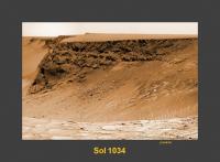
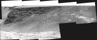
Six image mosaic from sol 1034
|
Posted by: CosmicRocker Dec 23 2006, 05:36 AM
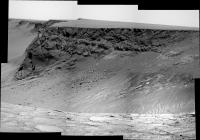
Nice one, alan. I loved the view of the tracks in that direction. The largest block in the ejecta layer on the left right side looks eerily familiar to me.
Here is the panorama in the drive direction. I think this provides the first good view of one of the north side dark streaks. What do you people think? I can't imagine what else it could be.
I wasn't expecting them to have quite as much contrast. I wonder if we'll be able to finally settle the discussions regarding whether they are light dust removal or dark dust deposition features when we get closer views.
|
Posted by: antoniseb Dec 23 2006, 01:37 PM
|
|
This really shows that there is a difference in the amount of dust on the North side faces as opposed to the South side faces. If we only have one shot to pick a place for Opportunity to examine, that's a big clue.
Posted by: mhoward Dec 23 2006, 04:55 PM
Gotta love those tracks.
http://www.flickr.com/photo_zoom.gne?id=330986373&size=o
Posted by: Steve Dec 23 2006, 05:10 PM
Here is the panorama in the drive direction. I think this provides the first good view of one of the north side dark streaks. What do you people think? I can't imagine what else it could be.
I wasn't expecting them to have quite as much contrast. I wonder if we'll be able to finally settle the discussions regarding whether they are light dust removal or dark dust deposition features when we get closer views.
It's interesting that while, according to the drive maps, we crossed over a faint dark streak at the head of Bottomless Bay between Sol 1027 and 1028, there has been no mention of pausing to look at the streak then.
If this seems an important question, it suggests that Opportunity will continue her circuit of Victoria at least until she reaches the really dark north streaks (around bay C5 and D2 in the unofficial nomenclature).
Steve
Posted by: Tman Dec 23 2006, 05:19 PM
Yeah very nice composition!
And also (gotta lov...) your perfectly stitched mosaics!
Posted by: dilo Dec 23 2006, 05:53 PM
I was doing the same but completely manual (I din't like AS output) and with sharpening:
|
Beautiful traks and stratified rocks, illumination is great and Capes sequence on the left is terrific... but, I'm still asking why we didn't visited Beacon balcony??

Posted by: jvandriel Dec 23 2006, 08:08 PM
The panoramic view from Sol 1030
taken with the L0 Navcam.
After adding the bottom 3 images the matching of the horizon
is not perfect.
jvandriel
|
Posted by: jvandriel Dec 23 2006, 08:18 PM
Here is the same view, but now without
the bottom row images.
jvandriel
|
|
Posted by: Stu Dec 23 2006, 09:00 PM
Nice view from here...
|
Posted by: jvandriel Dec 23 2006, 09:16 PM
Here is the panoramic view from Sol 1032.
Taken with the L0 Navcam.
jvandriel
|
|
Posted by: Stu Dec 24 2006, 06:58 AM
Would be a lovely sunset here... (I bet the Sun direction isn't correct but hey, just going for "pretty"! )
|
Posted by: jvandriel Dec 24 2006, 08:43 AM
A Christmas view on Mars.
Taken on Sol 1034 with the L7 Pancam.
jvandriel
|
Posted by: dilo Dec 24 2006, 08:43 AM
Beautiful mood, Stu!
Here below jv-based polar projection:
|
Posted by: nprev Dec 24 2006, 09:10 AM
Gotta love all those beautifully layered rocks, too. Oh, to have one of those in front of me with a pick handy to split the layers apart...
BTW, great image, Stu...it's now my desktop!
Posted by: jvandriel Dec 24 2006, 10:38 AM
Here is the Navcam view from Sol 1034.
jvandriel

|
Posted by: jvandriel Dec 24 2006, 12:28 PM
The view in the drive direction on Sol 1034.
Taken with the L2 Pancam.
jvandriel
|
Posted by: jvandriel Dec 24 2006, 01:10 PM
A mosaic of 2 images made by the Mi Cam
on Sol 1035 after brushing.
jvandriel
|
Posted by: fredk Dec 24 2006, 06:31 PM
Festive red/green images of Mars. Looking across Bottomless Bay, sols 1034 and 1036 long baseline stereo, L7 pancam:
|
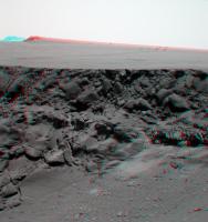
|
As others have said, I love that view of the tracks coming over the ridge leading to the beacon.
I don't have my red/green glasses with me, so I hope the channels aren't switched!
Posted by: jvandriel Dec 24 2006, 07:48 PM
The view until now.
Taken with the L7 pancam on Sol 1034.
jvandriel
|
Posted by: Bob Shaw Dec 24 2006, 10:36 PM
I've commented elsewhere re Victoria's morphology, and pictures such as these simply reinforce my view that Victoria isn't an impact crater.
It was, once, of course. But since then it's suffered an almighty erosional process, so that the high-velocity artefacts imposed on the pre-existing stratigraphy have been for all intents and purposes removed. Thus, no boulder field at the rim, no overturned strata, and probably not even any shock cones. Instead, we have a pit, transformed by erosive processes from a crater - with the inevitable jumbling of histories which that would imply - into a real cross-section of Meridiani Planum. Really, it's far *more* scientifically interesting as a pit than as a crater.
I'd propose that such ex-craters should be named 'Diablos', after the original (well, Spanish) name for the Barringer Crater, before it's external origin was discovered.
Bob Shaw
Posted by: mhoward Dec 25 2006, 03:14 AM
75x45 degree perspective view... Happy Holidays...
http://www.flickr.com/photo_zoom.gne?id=332348084&size=l
http://www.flickr.com/photo_zoom.gne?id=332355163&size=l
Posted by: Ant103 Dec 26 2006, 09:17 AM
Very good Michael
Here is a more natural colorisation of the panorama :
http://www.astrosurf.com/merimages/Images_opportunity-2006.html#Sol1036
I've also made a desktop picture (2Mo png)
http://www.astrosurf.com/merimages/Desktop/CapeSaintMary-Sol1036-desktop.png
Posted by: Tman Dec 26 2006, 10:15 AM
Beautiful!
Also the sight along the rim is specially great at this position.
Posted by: Stu Dec 26 2006, 04:37 PM
Just trying something a little different...
|
Love this location, but can't wait to move a little farther around the edge to see some new details...
Posted by: Tesheiner Dec 26 2006, 05:40 PM
> ... can't wait to move a little farther around the edge to see some new details...
You won't wait too much. Today is driving sol (1039) and we should have new pics in a few hours.
Posted by: Pando Dec 26 2006, 08:16 PM
Yes, something in the order of 55+ meters. There will be some nice new vistas of the Bay of Toil.
Posted by: DFinfrock Dec 27 2006, 01:09 AM
Ant,
I really appreciate when you add the desktop wallpaper versions.
That is really helpful for us image-challenged types.
David
Posted by: CosmicRocker Dec 27 2006, 05:56 AM
Stu: Am I interpreting that correctly? Is that Jack Frost nipping at the plains of Meridiani?
So, next up is the Bay of Toil. Sounds difficult.  The unfolding vista is pretty awesome. If they actually achieved 55 meters, it would have unfolded more awesomely, but it appears that the result of the 1039 drive was more like 23-25 meters. It looks like the next drive isn't in the tracking database yet.
Posted by: Stu Dec 27 2006, 07:53 AM
Sadly not, it's just some weird "huh?" result of my messing about with the colours...
As usual I'm not trying to be 100% colour accurate, but rather going for a "look" and a "feel". I leave the colour perfection to others here with about a gazillion times more expertise than I! The new view's opening up nicely tho...
|
Posted by: Bob Shaw Dec 27 2006, 09:12 AM
Stu:
Interesting colours, rather Bonestellian in tone...
...now, where *did* I park that big glider?
Bob Shaw
Posted by: edstrick Dec 27 2006, 11:22 AM
Hang-gliding on Mars will be only a little more risky than base-jumping with a un-anchored bungee-cord!
Posted by: Ant103 Dec 27 2006, 11:25 AM
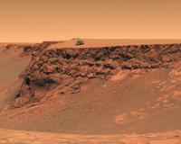
Thanks for your comments
Here is a version with the rover to have a scale of the structure :
|
(sorry for some inclusion trouble, it was a little hard to cut out the rover from JPL press release image)
Posted by: ngunn Dec 27 2006, 03:17 PM
Great to have you back Bob. New computer for Christmas, was it? Time has flown, but not nearly enough bananas.
Posted by: Nirgal Dec 27 2006, 05:48 PM
Wonderful image, Ant ! nice atmospheric color mood and the rover really adds a sense of scale to the cliffs
Posted by: jvandriel Dec 27 2006, 08:07 PM
Here is the 360 degree panoramic view taken on Sol 1039
with the L0 Navcam.
jvandriel
|
|
Posted by: Bob Shaw Dec 27 2006, 08:49 PM
Yes, my siggy has vanished; and no, my cable provider fixed what was wrong (although yes, I have a nice new (to me) dual-processor 800Mhz G4 Mac which despite being a couple of years behind the bleeding edge of computational kit still goes like the proverbial clappers - but this is being typed on my good ol' Dell Latitude C840!).
What I *have* just got, though - prepare to swoon - is an A3 colour laser printer *and* an industrial-scale printer/plotter. Panoramas are calling!
Must find me some bananananas!
Bob Shaw
Posted by: Stu Dec 28 2006, 06:28 AM
Very pretty ledge over there, look...

|
Posted by: kenny Dec 28 2006, 02:30 PM
Steve S confirms that both Bottomless Bay and Duck Bay are feasible entry points, but not yet confirmed as feasible exit points.
http://www.space.com/missionlaunches/061228_rovers_update.html
So far we have found two safe entry routes into Victoria. Those are Duck Bay and Bottomless Bay. We have not yet confirmed that either is a safe exit route, but they both have potential, Squyres advised.
Posted by: Tesheiner Dec 29 2006, 12:55 PM
Yestersol (1041) the rover moved to a point right inbetween the two promontories B1 and B2, probably to spend the weekend at this site doing some IDD work. BTW, does this cape has an "official" name so I can update the route map?
Here is part of the navcam mosaic taken on that sol, mainly looking to the northern rim, in which I tried to identify some nearby features. The next cape northward (B3) is barely visible on the images so looks like it is pointing downwards in a similar way as Cabo Verde. Some features from C1-C2 can be seen behind and to the right of B3.
There is a feature that looks like exposed bedrock in the path from here to B3 and it can be clearly correlated on the HiRISE image too. Would it be the next stop?
|
|

|
Posted by: Floyd Dec 29 2006, 03:50 PM
I would hope that Opportunity goes right to the edge of B2--just a bit to the right of your green arrow. We would get a great view of neighboring bays and capes.
Posted by: jvandriel Dec 29 2006, 08:49 PM
Here is the Navcam view from Sol 1041.
Taken with the L0 Navcam.
jvandriel

|
Posted by: ustrax Dec 29 2006, 10:52 PM
There is a feature that looks like exposed bedrock in the path from here to B3 and it can be clearly correlated on the HiRISE image too. Would it be the next stop?
Not that I know of...
Here's the original suggestion I've sent to Steve:
"Another thing, as Opportunity is moving towards Victoria I leave you a suggestion, it would be great to see the rover arriving at the crater and making it's circumnavigation as Magellan did around the world almost 500 years ago aboard the vessel that gave her the name. What about naming each stop or feature of scientific study with places where the original Victoria set anchor? That would catch the spirit of adventure this rover is living...And there are some curious ones...:
Zebu; Seville; Tenerife; Cape Verde; Brazil; Cabo-Frio; Rio de Janeiro; River of St. Christopher; Point St. Antony; Cape St. Apelonia; Shoals of the Currents; Island of St. Matthew; Bay of Labors; Port of St. Julian; Santa Cruz; Cape of the Virgins; Thieves' Island; Phillippines; Island of Good Signs; Valley Without Peril; St. Lazarus; Macangor; Cabo Matam; Borneo; Carpyam; Caram; Dygua'am; Vay Palay Cucara Canbam; Bolyna; Bamdym; Islets of St. Paul; Mount St. Paul; Island of the Myrolobans; Port St. Mary of August; Quipe; Tamgym; Maluco; Tydor; Targatell; Ternate; Timor; Betachina; Porquenampello; Cape of Palms; Quimar; Camarfya Charam; Islands of St. Antony; Cyco; Quamgragam; Pamo; Camafo; Geilolo..."
Maybe we should expect a Point St. Antony before a Cape St. Apelonia?...
That feature looks to me like it is on the opposite side of the next bay, following the suggested: Shoals of the Currents (I just love this name!!)
Edited concerning aditional named features.
Posted by: ustrax Dec 29 2006, 11:28 PM
Tesheiner...
Yhttp://marsrovers.nasa.gov/mission/status.html#opportunity
I don't know what's the reason for those spanish regions (maybe a tribute to the sailors?) but they're there...
VIVA TIMOR! (Can someone point me out where it is?)
I'm still waiting for a Sabrosa location (the place where Magalhães was born...)...
Posted by: Shaka Dec 29 2006, 11:31 PM
Let's hope the bay we descend into Victoria is named "Valley without Peril"!
Posted by: ustrax Dec 29 2006, 11:34 PM
Awesome...That would be awesome!
Posted by: diane Dec 30 2006, 12:24 AM
I'd like to suggest that the first entry point should be Umatac Bay (Guam) which was Magellan's first landfall after crossing the Pacific.
Posted by: CosmicRocker Dec 30 2006, 05:31 AM
I think they should save "Shoals of the Currents" for the location where the first festoons are observed.
Posted by: jvandriel Dec 30 2006, 02:57 PM
Here is the complete view from Sol 1041 and Sol 1042.
Taken with the L0 Navcam.
jvandriel

|
Posted by: Tesheiner Dec 30 2006, 02:58 PM
Yhttp://marsrovers.nasa.gov/mission/status.html#opportunity
Maybe. I will include some additional ground feature names from time to time; not all of them otherwise the map would be too cluttered.
Names of brazilian locations were (and will be) included for obvious reasons.
Posted by: mhoward Dec 30 2006, 03:20 PM
An alternate version if the sol 1041-1042 Navcam pan:
http://www.flickr.com/photo_zoom.gne?id=338479028&size=o
Posted by: mhoward Dec 30 2006, 03:49 PM
Here's a perspective view (105x80 degrees)
http://www.flickr.com/photo_zoom.gne?id=338501373&size=l
Posted by: ustrax Dec 30 2006, 04:33 PM
Looks good to me...
EDITED: And CosmicRocker suggestion too... I was expecting Cebu (the place where Magellan died) to be kept safe for Oppy's final rest in case of she didnt't make out of Victoria...Thta can only be a good sign...
...And Tesheiner...You have to include ALL the names...
Posted by: mhoward Dec 30 2006, 04:42 PM
Here's a larger screen-sized version, doctored slightly. The "original size" image on Flickr is a PNG, if anyone wants to have a go at doctoring this with more sophisticated tools than "Paint".
http://www.flickr.com/photo_zoom.gne?id=338553151&size=l
Posted by: Phil Stooke Dec 30 2006, 09:39 PM
Just back from a trip - and what better way to celebrate than this? A polar view of jvandriel's latest pan.
Phil

|
Posted by: Stu Dec 31 2006, 10:02 AM
Another nice view...

|
Posted by: Bob Shaw Dec 31 2006, 01:20 PM
Stu:
Remember your old speculative image of Opportunity sitting on the rim of Victoria? I thought at the time that it was overly dramatic, but I think I was, oh dear, what's the word, one I don't use much... ...wrong!
Do you fancy reposting it?
Bob Shaw
Posted by: Stu Dec 31 2006, 01:35 PM
Bob,
Not sure which one you mean, but here are my two "craziest"...

|
or..

|
Posted by: Bob Shaw Dec 31 2006, 01:44 PM
Stu:
No, not those - it was one of your first efforts, well before Victoria was anything other than an argument on the horizon!
Bob Shaw
Posted by: leustek Dec 31 2006, 03:41 PM
EDITED: And CosmicRocker suggestion too... I was expecting Cebu (the place where Magellan died) to be kept safe for Oppy's final rest in case of she didnt't make out of Victoria...Thta can only be a good sign...
...And Tesheiner...You have to include ALL the names...
That would be a poetic end, but not appropriate for Oppy. Magellan was killed on Cebu because he was diverted from the mission of exploration on which he set out, by becoming involved in inter-tribal politics as he tried to force Christianity onto the natives. Magellan, who is associated with the first circumnavigation, actually made it only half way around. The real success is that the littlest of his 3 ships Victoria was the only one to complete the circumnavigation. It limped back to Seville with broken mast, badly leaking hull, 18 surviving crew of 235 that began the mission, and full of valuable spices. This epic ending would better be emulated if Oppy were to continue her mission until her power dips into the death zone.
Speaking of power, does anyone know what the power output is of Oppys panels? Is dust accumulating on the down-wind side of the crater?
Posted by: MarkL Dec 31 2006, 04:04 PM
It's true Magellan didn't make it back home, but he had been further east on a previous voyage so he still gets credit for being the first man to circumnavigate the Earth. Or maybe it was his slave Enrique. Anyway, not seeking to open the debate, just correct a common misconception.
Posted by: Stu Dec 31 2006, 10:11 PM
Ahhhh... this one..?

|
Posted by: Bob Shaw Jan 1 2007, 12:01 AM
Stu:
The very chap!
Bob Shaw
Posted by: jvandriel Jan 1 2007, 11:51 AM
For all the members and readers of this website:
Happy New Year.
jvandriel
Posted by: jvandriel Jan 1 2007, 12:54 PM
and to start the New Year good:
here is the 360 degree panoramic view taken on Sol 1044
with the L1 Pancam.
jvandriel
|
|
Posted by: Nirgal Jan 1 2007, 07:00 PM
here is the 360 degree panoramic view taken on Sol 1044
with the L1 Pancam.
jvandriel
Wow, what a view again ! every time you think those views can not get more scenic & dramatic :-)
Let me take this Opportunity for a special thank you to jvandriel for his prompt and continuous
near-realtime
supply with always the latest navcam panorama-stitches, many of which inspired me for one of my own colorizations in the first place ... !Thanks
Posted by: PhilCo126 Jan 2 2007, 04:53 PM
I'm using the CapeSaintMary as desktop background its' truly amazing !!!
Posted by: jamescanvin Jan 5 2007, 08:03 AM
A bit late with this Christmas stuff but here is my version of the sol 1036/7 view back across Bottomless bay.
http://www.physics.usyd.edu.au/~jcanvin/mer/index.html#B1036
And here is the long baseline (~2.5m) anaglyph pan from sol 1034 & 1036/7
http://www.physics.usyd.edu.au/~jcanvin/mer/index.html#B1034
James
Posted by: Ant103 Jan 5 2007, 11:01 AM
Good work James
I think thatt is the first time that we have the same colors .
Posted by: mhoward Jan 5 2007, 05:41 PM
http://www.flickr.com/photos/marscat/346283571/
Looks like there is some interest in the float.
BTW I found a GreaseMonkey http://userscripts.org/scripts/show/4771 that translates Flickr to BBCode - very useful if you use Flickr and want to post images to a forum like this one.
Posted by: jvandriel Jan 6 2007, 12:47 PM
The view in the drive direction on Sol 1049.
Taken with the L2 Pancam.
jvandriel

|
Posted by: fredk Jan 7 2007, 05:19 PM
Some interesting details from the latest http://marsrovers.jpl.nasa.gov/mission/status_opportunityAll.html#sol1043
Other activities included analysis of cobbles nearby that may be similar to Santa Catarina. Based on the results, members of the science team will either decide to stay and continue investigating the rocks or drive toward the next promontory of Victoria Crater.
Posted by: mhoward Jan 7 2007, 05:46 PM
I was thinking those rocks looked pretty shiny. I was wondering if they could be meteorites that were left behind as the material surrounding them eroded. They've imaged several of them now:
http://www.flickr.com/photos/marscat/349194503/
A little L456 false-color:
http://www.flickr.com/photos/marscat/349188063/
I think the rocks to the right in that last close-up are considerably brighter than they appear in this rendering... the way they stretch those raw image JPGs loses a lot of brightness information, and it's impossible to get it back by "de-stretching". Caveat emptor.
Posted by: Stu Jan 7 2007, 05:57 PM
I said a few posts back that I think they've found another meteorite here, it looked a lot like an iron meteorite to me... Perhaps Oppy has wandered into a "strewn field"... if so, I'm just surprised it didn't happen earlier to be honest.
Posted by: Edward Schmitz Jan 7 2007, 08:32 PM
fragments from the impactor that produced VC? Maybe?
Posted by: CosmicRocker Jan 8 2007, 06:47 AM
Santa Catarina doesn't look like any meteorite I've seen before. It seems to contain a population of angular fragments and another population of very rounded ones. It, and the other nearby float have very different appearances and weathering characteristics, compared to other pieces of float we've seen. I wonder if they might have eroded out of the ejecta.
I see that Opportunity will be forced to go closer to that outcrop behind B3. I can't wait.
Posted by: Tesheiner Jan 8 2007, 11:02 AM
Indeed. Here is a polar projection including the location of all those cobbles, except for two of them supposely imaged on sol 1048 but not yet downlinked so I couldn't locate them.
FWIW, all these features, except the last one, are taking the names of cities related to Santa Catarina (a state in southern Brazil, light green in the picture). You can find them on the following picture too.

|
Posted by: hortonheardawho Jan 8 2007, 01:31 PM
Tesheiner, with your permission, I would like to use this map as a base to link to the 3D color images.
Posted by: Tesheiner Jan 8 2007, 01:51 PM
It will be a pleasure.
Posted by: hortonheardawho Jan 8 2007, 02:39 PM
Thanks Tesheiner.
http://www.flickr.com/photos/hortonheardawho/350416874/ is the linked images from the map.
Posted by: jvandriel Jan 8 2007, 07:27 PM
Here is the view in the drive direction on Sol 1051.
Taken with the L2 Pancam.
jvandriel

|
Posted by: climber Jan 8 2007, 07:35 PM
Taken with the L2 Pancam.
jvandriel
That's exciting! A Cape lower than the others will allowed a nice "from the sky" view.
I also notice that we get closer to the horizontal terrace were "caves" could be located on the east-southern part of VC.
Posted by: Tesheiner Jan 8 2007, 08:19 PM
Pretty nice idea! I like it.
Just saw the plan for the next sols and there are more image targets before moving ahead (btw, no driving plan yet). I'll keep the basemap updated in the mean time.
I'm wondering if some of the outcrops visible at the top of cape C1-C2 are part of the "bright layer" we saw at Duck Bay and also at Bottomless Bay.
Posted by: dilo Jan 8 2007, 08:44 PM
http://www.flickr.com/photos/hortonheardawho/350416874/ is the linked images from the map.
This is wonderful!
I'm amazed by this work, my wild dream is now about entire Mars atlas like this...
Thanks and congratulations!
Posted by: Shaka Jan 8 2007, 11:19 PM
Right, Tesh, do the codes tell you what is happening at Catarina. I hope we're Ratting and doing spectroscopy; I'm aching to see what's under the dust.
Posted by: Shaka Jan 8 2007, 11:24 PM
You bet, Dilo. A year ago I was urging JPL/NASA to put together the whole MER missions like this, with nested hot links to all the data. If they don't get a move on, Horton may beat them to the punch!
Posted by: jamescanvin Jan 9 2007, 02:12 AM
Well I'm not Tesh, but as a fellow tracking site gazer I think I can tell you what we know.
The most resent front hazcams are from sol 1049 and are listed as
So I think we can be fairly sure that Oppy is in the process of doing a lengthy Mössbauer integration on Santa Catarina at the moment. Just more pancam targets for tosol so looks like there is still a while to go yet...
James
Posted by: fredk Jan 9 2007, 02:50 AM
I wonder what the latest status is on this problem, from http://marsrovers.jpl.nasa.gov/mission/status_opportunityAll.html#sol1043
Posted by: nprev Jan 9 2007, 03:18 AM
Random (& probably completely unoriginal) thought here, but what are the odds that a significant fraction of ALL the cobbles Oppy has seen in Merdiani are actually meteorites? After all, the richest 'meteorite-mining' areas on Earth are North Africa & Antarctica, which both feature homogeneous, fine-grained native surface materials.
If this conjecture is accurate, then Meridiani may be a true scientific treasure trove in yet another sense.
Posted by: alan Jan 9 2007, 03:33 AM
Pancam site's version of Bottomless Bay.
http://marswatch.astro.cornell.edu/pancam_instrument/1037B_bottomless_bay.html
Posted by: climber Jan 9 2007, 06:28 AM
If this conjecture is accurate, then Meridiani may be a true scientific treasure trove in yet another sense.
You know, this one/month "big" crater formation detected by MGS could lead to quite a lot of "smaller size" meteorids to fall on Mars frequently. The surface of Mars is quite undisturbed for eons, so, a place like Meridiani with only a few natives rocks around should be a paradise, you're right. I wonder if we can put these two issues together and start some statitics of meteroids numbers from small to crater-doing size.
Posted by: Bob Shaw Jan 9 2007, 08:45 AM
I wonder if there are areas on Mars where meteorites naturally get concentrated? The edges of the northern polar cap, etc?
Bob Shaw
Posted by: Tesheiner Jan 9 2007, 10:02 AM
Agree. It's also noted on the last status report:
Opportunity continued scientific studies of a rock called "Santa Catarina" on the rim of "Victoria Crater." Scientists suspect that Santa Catarina may be a meteorite or a rock blasted out from beneath the surface of Victoria. Opportunity collected extensive measurements to determine the iron content of the rock using the Mössbauer spectrometer and will continue to do so during the coming week.
Here is an updated "map" of the targets on the current site. Did some corrections too, because I thought all names were related to cities but few of them are of Santa Catarina's rivers.

|
Posted by: ustrax Jan 9 2007, 10:31 AM
There's a Mafra in Brasil Tesh? That I didn't knew...
The original is 20kms from my house and surely (more even if you've read Saramago's http://www.amazon.com/Baltasar-Blimunda-Jose-Saramago/dp/0156005204) deserves http://www.cm-mafra.pt/turismo/eng/sightseeing.asp...
EDITED: Of course...I suspected...there's also a http://www.glosk.com/BR/Cintra/-898607/index_pt.htm in Brasil...
Posted by: Tesheiner Jan 9 2007, 11:47 AM
Yup.
http://pt.wikipedia.org/wiki/Mafra_%28Santa_Catarina%29
Edited: To be fair, when I first saw the target's name I though in Portugal's Mafra, but then I said to myself "what if" ... and bingo!
If they keep the current naming pattern we may find http://www.guianet.com.br/sc/mapasc.gif in the following sols before moving for good.
Posted by: ustrax Jan 9 2007, 12:32 PM
Be honest...You'd bite a meteorite to have Porto Alegre up there wouldn't you?...
Posted by: Tesheiner Jan 9 2007, 01:00 PM
... or two.

Posted by: ustrax Jan 9 2007, 01:54 PM
Here is an updated "map" of the targets on the current site. Did some corrections too, because I thought all names were related to cities but few of them are of Santa Catarina's rivers.
I don't see http://marsrovers.nasa.gov/mission/status.html there, are they out of the image range?
Posted by: Tesheiner Jan 9 2007, 01:58 PM
They were expected to be imaged on sol 1048 but there are no data downlinked for that sol. Might be on the queue or perhaps aborted.
01048 p2554.17 13 13 0 0 2 28 pancam_chapeco_L234567Rall
Edited: Re-planned to be imaged on sol 1053.
01053 p2563.17 13 13 0 0 2 28 pancam_chapeco_L234567Rall
Posted by: hortonheardawho Jan 9 2007, 02:48 PM
[quote name='Tesheiner' date='Jan 9 2007, 08:58 AM' post='79819']
They were expected to be imaged on sol 1048 but there are no data downlinked for that sol. Might be on the queue or perhaps aborted.
Mafra and Peixe 3D links now added to the http://www.flickr.com/photos/hortonheardawho/350416874/.
Er, does anyone find it interesting that target http://www.flickr.com/photos/hortonheardawho/351677326/ is named after a river?
Posted by: djellison Jan 9 2007, 03:18 PM
Nothing strange about naming it after a river - we've splattered the names of lakes all over Gusev.
Doug
Posted by: Stu Jan 9 2007, 05:29 PM
Broken-up-on-impact meteorite?

|
Posted by: Floyd Jan 9 2007, 06:30 PM
Looks to me like its just a dead crow.
Floyd
Posted by: tty Jan 9 2007, 09:41 PM
Floyd
West Nile virus strikes Mars!
Posted by: Tesheiner Jan 10 2007, 09:10 AM
Updated the http://www.unmannedspaceflight.com/index.php?s=&showtopic=3544&view=findpost&p=79794 with the latest targets "http://nasa.exploratorium.edu/mars/opportunity/pancam/2007-01-09/1P221663599ESF7800P2562L7M1.JPG" and "http://nasa.exploratorium.edu/mars/opportunity/pancam/2007-01-09/1P221664038ESF7800P2563L7M1.JPG".
Posted by: hortonheardawho Jan 10 2007, 07:02 PM
http://www.flickr.com/photos/hortonheardawho/352976580/ and http://www.flickr.com/photos/hortonheardawho/352976800/ links added to http://www.flickr.com/photos/hortonheardawho/350416874/
Posted by: Tesheiner Jan 11 2007, 09:28 AM
Just checked the planned sequences for sol 1055 (tomorrow): MI and drive. Finally!
Edited: I'll bet for a 30m drive eastwards up to the rim, next to Bay of Toil.

No new imaging targets on the plan.
Posted by: Shaka Jan 11 2007, 06:54 PM
Is the MI sequence of S. Catarina where it was ratted?
After all the portraits of ejecta float in the surroundings, one might expect a close-up look at one or two. That could depend on what Catarina showed, I suppose. Bedrock is fundamentally more informative than float. I still wonder whether we are driving across in situ, though fractured evaporite or jumbled ejecta.
Posted by: fredk Jan 14 2007, 12:31 AM
Apparently the final word on Santa Catarina from the latest http://marsrovers.jpl.nasa.gov/mission/status_opportunityAll.html#sol1049
Also an update on the rat problem:
Posted by: CosmicRocker Jan 14 2007, 06:31 AM
Darn, I should have kept my mouth shut when I previously said it didn't look like any meteorite I've seen. I guess it's some variety of chondrite. Could someone knowledgeable of meteorites chime in?
Posted by: Stu Jan 14 2007, 08:52 AM
If we're talking about the same rock (I've lost track a bit) I'm sure I first suggested it was a meteorite somewhere in the "Victoria Stratigraphy" thread soon after it was spotted... I can't claim to be knowledgeable, but it did ring a bell... and that "Dead Crow" looks even more like a shattered meteorite now, too...
Posted by: nprev Jan 25 2007, 03:47 AM
According to Steve's latest http://athena.cornell.edu/news/mubss/, (and thanks to Bobby for the heads-up! ) he states that Santa Catarina is the "fifth one [meteorite] we've found". Was he referring to Oppy alone, or also including Spirit? I only recall the "Iron Basketball" way back near the heatshield.
Powered by Invision Power Board (http://www.invisionboard.com)
© Invision Power Services (http://www.invisionpower.com)