Printable Version of Topic
Click here to view this topic in its original format
Unmanned Spaceflight.com _ Opportunity _ Leaving Victoria crater
Posted by: fredk Aug 3 2008, 08:50 PM
I guess "to the cape" no longer applies, so a new thread is in order. From http://www.planetary.org/news/2008/0731_Mars_Exploration_Rovers_Update_Spirit.html
The plan is to exit via the entry route.
Also some interesting news on the next destination from the same article:
Posted by: Oersted Aug 3 2008, 08:55 PM
Oh no, that's really sad news. Having to drive out of the crater just as we were nearing the cliff face...
Posted by: Stu Aug 3 2008, 08:56 PM
Wow... she really is leaving...
OK, then thanks for showing us such sensational sights Oppy, we're all very proud of you back here. Now, get yourself out again, take a breather in the full sunshine - you've earned it - and then head on for sights and wonders new. 
Posted by: Tesheiner Aug 3 2008, 09:48 PM
Well, time to leave.
It was becoming really difficult, if not impossible, to get to that wall so I understand the change of plans. In any case, if the left front wheel really stalls I have the feeling it will be "end of mobility" anywhere; here or at the plains. This terrain, Meridiani, is too sandy to drive with a stuck wheel.
Posted by: dot.dk Aug 3 2008, 10:17 PM
Erebus fits that distance and heading.

Posted by: Sunspot Aug 3 2008, 10:25 PM
But Erebus isn't unnamed lol 
Posted by: briv1016 Aug 3 2008, 10:33 PM
Do they have plans to take a full pan of the wall first or are they trying to get out of there like bat out of hell?
Posted by: nprev Aug 3 2008, 10:35 PM
Guess that damn slope & the slippery terrain was just too much for her....dammit.  One hell of an effort, in any case, and safe journey to Erebus!
Posted by: mike Aug 3 2008, 11:13 PM
Huh. Do you suppose they'll get another chance to look at rock this deep? They never really imaged any of the wall closely. And now they suddenly have to leave. Most mysterious.
Posted by: Bobby Aug 4 2008, 12:10 AM
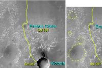
In the current Planetary Society Mars Rover Update. Opportunity will start to explore the cobbles after leaving the slippery slopes of Victoria Crater and then head about 2 kilometers to the north/northwest from its current location to an unnamed crater. Does anyone have any overhead views which might show which crater they are talking about?
Posted by: BrianL Aug 4 2008, 12:51 AM
So, it's back to Erebus.  Oh well, at least she has a track to follow now.
Posted by: nprev Aug 4 2008, 01:06 AM
Gonna go out on a limb here & suggest that that wheel stall was the decision point event. The terrain here is supremely difficult, with occasional slippage rates greater than 90%; getting stuck for good right now wouldn't seem to be in the mission's best interest if they can do other things within the vehicle's capabilities.
Posted by: mike Aug 4 2008, 02:15 AM
I recall them saying they'd go into the crater even if they got stuck there forever. Ah well, maybe they won't be able to make it out and they'll look at the wall after all.. I doubt there's anything comparable out on the plains.
Posted by: Shaka Aug 4 2008, 04:39 AM
Yes, the maximum-age layers remain unanalyzed.
But, truth be told, I have searched long for visually distinctive strata, and seen nothing striking.
It was always a small hope - a couple of dozen meters out of 800.
Perhaps we should strive for new horizons.
(sound of piteous sobs and sighs...)
Posted by: djellison Aug 4 2008, 06:25 AM

And I have explicitly heard Squyres say they're had no intention of getting stuck and always intended to get in - do science - and get out.
Posted by: Aussie Aug 4 2008, 08:32 AM
A good call by the team. Condition monitoring revealing a high probability of a known failure mode, get the rover to a position where some movement will be possible. High slippage slopes and dunefields are not a good environment and a crater over a kilometer away would seem a touch risky, so maybe they will stick to the annulus. But who knows. The design of these vehicles is a tribute to all those involved and they just keep hanging in there.
Posted by: Oersted Aug 4 2008, 09:11 AM
Hardly mysterious, unless you really want to see a conspiracy. The decision making process regarding the rovers has always been extremely open, with all the facts laid bare to the interested public. Much more information than we could demand.
Posted by: centsworth_II Aug 4 2008, 09:28 AM
Not bedrock, but they want to get out and look at the cobbles. These may have come from much deeper... or far away. I don't know what the thinking is on their origin.
Posted by: TheChemist Aug 4 2008, 09:31 AM
We should not forget that one of the great benefits of the rovers being so long-lived, is that the scientists can do "target research".
It is quite possible that full analysis of data obtained "in a hurry" while traveling south to reach Victoria has lead to important clues that call for
a second more detailed look (i.e. the cobbles in this case). If the scientists judge that the benefits of examining the cape's walls are less
prominent than their new science target, it is not a surprise that they choose to get out and pursue that target instead.
PS. Not to mention the "born to be wild" feeling of roving in the plains, too
Posted by: mike Aug 4 2008, 02:14 PM
I'll have to go to Mars myself..
Posted by: fredk Aug 4 2008, 02:52 PM
From the http://www.planetary.org/news/2008/0731_Mars_Exploration_Rovers_Update_Spirit.html:
And underneath that dune field?
"Another dune field," offered Hayes. "It might be either be a completely different dune field below it or it could be that the dune field we're looking at was part of a very, very large dune field. You can have dunes running on the back of other dunes, so it can either something like a 10-to-30-foot dune riding on back of a 100-foot dune field or it's another dune field from another time."
Anyone offer a guess as to which super-res sequence shows this?
Posted by: Bobby Aug 4 2008, 03:50 PM
Does anyone have any overhead views of the area to the North of Victoria that might show this unnamed crater. I have a feeling it's not Erebus
and it's another one.

Posted by: Pertinax Aug 4 2008, 05:20 PM
and it's another one.
http://marsrovers.jpl.nasa.gov/mission/tm-opportunity/images/MERB_766_1.jpg
FWIW, I don't see how it could be anything but Erebus.
-- Pertinax
Posted by: djellison Aug 4 2008, 05:30 PM
That's the wierd thing - Erebus (and Terra Nova, adjacent and overlapping) are both names - but are the only large craters to the NNW.
If, perhaps, they meant to say WNW, then there's a large eroded crater at that sort of range.
Doug
Posted by: algorimancer Aug 4 2008, 05:38 PM
Erebus. A bit boring, not the target I'd have chosen (Ithaca!), but at least the scenery will be changing. In many ways I prefer the journey to the destination.
Posted by: mhoward Aug 4 2008, 06:10 PM
It's been awhile since I've looked at the satellite images, but from what I remember (dunes, drifts, sand) I have a hard time understanding how they could go W-NW, even with perfect mobility. Cobbles are great, but sure would love to see some new terrain. Who knows, if they covered some new ground, maybe they might find some interesting cobbles.
Posted by: PaulM Aug 4 2008, 06:33 PM
Is this the super-res image of the lower dune field that interested Hayes and Lauren Edgar so much?:
http://marsrovers.nasa.gov/gallery/all/1/p/1576/1P268100469ESF90B0P2534R2M1.JPG
This image is part of a large set of apparently identical sub-frame images and so I assume that it is a super-res image. I would really appreciate it if someone was to process this image and other images of Capo Verde to bring out the details that interest MER geologists so much. The panorama which I have seen which seems to best show details of sedimentary structures is the following pan by ant103:
http://www.db-prods.net/blog/wp-content/uploads/2008/07/panol2-quickview.jpg
I think that this pan shows a sequence of cross bedded strata formed by winds blowing from South to North, followed by horizontally bedded strata, followed by cross bedded strata formed by winds blowing from North to South.
I realise that what I call horizontally bedded strata is actually tillted at about 10 degrees to the South. However what I am assuming is that the whole of the Capo Verde cliff has been tilted 10 degrees to the South by subsidence of the wall of Victoria crater.
Posted by: PaulM Aug 4 2008, 07:08 PM
On many occasions SS has expressed an interest in looking at cobbles on the plains after Oppy is finished with Victoria. I guess that his reason is that there is not much variety in the rocks of Meridiani and so the opportunity for Oppy to look at more meteorites and at rocks from elsewhere on Mars (such as "Bounce") is attractive.
I think that Oppy's first scientific target after it has left Victoria on its road to Erebus or a similar crater may be an exotic cobble close to Beagle crater described in the following Opportunity Update:
"Sol 875: ... Opportunity used its panoramic camera and miniature thermal emission spectrometer on a distant potential meteorite; ..."
There are nice color and false color photos of this rock in the following post:
http://www.unmannedspaceflight.com/index.php?s=&showtopic=2417&view=findpost&p=61844
The following map shows the general area that Oppy was in in SOL 875:
http://www.unmannedspaceflight.com/index.php?act=attach&type=post&id=7283
An advantage of Opportunity attempting to drive in the general direction of Erebus crater is that most of the journey could be accomplished without crossing ridge crests. Opportunity only got stuck in Purgatory because it attempted to cross a ridge crest.
Once Opportunity has passed Erebus crater then this will open up the possibility of Opportunity driving many many km across the very easy driving country it encountered at the start of its mission. Anyone who does not believe that Opportunity can drive at least another 12 km should read the following quote from the latest Planetary Society MER update:
These rovers are about 100 years in rover years, but who knows," Soderblom mused, "maybe they'll live to 200. The fact that they're still making such significant discoveries deep into their missions sort of says don't give up on these missions when they're halfway through," he said. We need to keep the funding there to let them get all the fruits they can."
Posted by: nprev Aug 4 2008, 08:17 PM
I'd like to see a focus on the cobbles as well. They're interesting, and probably have a variety of origins (mostly actual meteorites or ejecta from impacts, I'd suspect.) Either way, they seem to offer a way to examine materials from places beyond Oppy's physical capability to reach
Posted by: Shaka Aug 5 2008, 05:21 AM
Like these, for example: http://qt.exploratorium.edu/mars/opportunity/pancam/2006-05-26/1P201865458ESF71A3P2417R2M1.JPG
As we rolled by them, I thought it a shame that we didn't have time to poke around in there.
Maybe we'll get another chance on the way back up north.
Posted by: Stu Aug 5 2008, 05:51 AM
I hope we'll get a closer look at http://www.unmannedspaceflight.com/index.php?s=&showtopic=4151&view=findpost&p=94173 rocks, they fascinated me as we scooted on past, especially that hard-looking blocky one among the crumbly-looking ones (apologies for the technical terms!)...
|
Posted by: dvandorn Aug 5 2008, 06:00 AM
Oh, come now, Stu -- you *know* that geologists just made up words like "friable" so's they could say a rock was crumbly and sound all ed-jee-cated while saying it... 
-the other Doug
Posted by: CosmicRocker Aug 5 2008, 06:40 AM
I am so ready to get get back out on the plains in search of the cobble float! Giddyup. I have my list of favorites that were neglected back up the trail. This should be fun. 
|
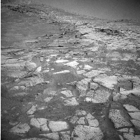
It's curious that they suggested that highres and superres imagery helped identify the contact. It was pretty apparent in previous images and panoramas, and http://www.db-prods.net/blog/wp-content/uploads/2008/07/panol2-quickview.jpg that you linked to. Perhaps those images were the highres ones they referred to.
But to be honest, I have to agree with shaka. I've searched dilligently for distinctive stratigraphy/mineralogy, too, and I haven't seen it in the depths of this crater. Finding one fossil Martian dune field overriding a predecessor is a pretty nifty observation for a rover...don't get me wrong. I don't want to marginalize it. This is one for the robotic rockhound textbooks. But, such a thing is to be expected, and is a relatively common occurence in terrestrial rocks. Let's also not forget that there is another story of the rocks being collected by the MER's geochemical instruments, the details of which we have less access to, and which it seems apparent to this observer, that there is a rich story unfolding.
As we all consider the news about the discovery of the base of a dune unit, don't forget the qualifiers published in that update.
"Another dune field," offered Hayes. "It might be either be a completely different dune field below it or it could be that the dune field we're looking at was part of a very, very large dune field. You can have dunes running on the back of other dunes, so it can either something like a 10-to-30-foot dune riding on back of a 100-foot dune field or it's another dune field from another time."
Oh yeah, and did I note that they appeared to be friable, as well?

Posted by: ustrax Aug 5 2008, 07:30 PM
I'm happy...*
How could we ever reach Ithaca from inside that crater?...
* and back...
Posted by: Stu Aug 5 2008, 07:41 PM
THERE you are!!!
(shouts off to the side: "It's okay guys, you can stop scanning Portugal with HiRISE, we've found him..." )
Posted by: Shaka Aug 5 2008, 07:58 PM
Thought you'd fallen into some abyss somewhere!
What do you hear from SS these days?

Posted by: ustrax Aug 5 2008, 08:00 PM
What do you hear from SS these days?
Not much...been sniffing to much perchlorate to know with certainty what I've been doing...
Posted by: Shaka Aug 5 2008, 08:09 PM
Didn't you see the Warning label on MECA?
"Don't try this at home!"
Posted by: ustrax Aug 5 2008, 08:49 PM
Hey! At my home I'm free to try what I want!
Posted by: climber Aug 5 2008, 09:56 PM
I knew you were an extremofree kind of guy...
Welcome back anyway on the other busy place of Mars
Posted by: BrianL Aug 6 2008, 05:37 PM
New hazcam pics at exploratorium show no significant movement. I'm thinking they will be giving this spot a name shortly. 
Edit: It even looks a bit like they might be trying to back up.
Posted by: fredk Aug 6 2008, 06:18 PM
There was a bit of a turn to the left. And http://qt.exploratorium.edu/mars/opportunity/rear_hazcam/2008-08-06/1R271306561EFF90DCP1314R0M2.JPG I'd guess they're doing these late shots to improve the lighting on the rear wheel area. But a few more of these shots and we'll have a nice sunset shadows animation!
Posted by: Tman Aug 7 2008, 05:47 PM
Still a difficult situation to get progress there
Yes, such an animation would be cool. From the update 02.08 there's an afternoon sun over the cliff around 14:54 LTST/sol1607. The only ground image that matches is from sol1603/11:46. However, the two merged looks nice:
|
Posted by: peter59 Aug 8 2008, 06:23 PM
Significant progress today. 
Sol 1612
http://qt.exploratorium.edu/mars/opportunity/forward_hazcam/2008-08-06/1F271289947EFF90DCP1214R0M1.JPG
Sol 1614
http://qt.exploratorium.edu/mars/opportunity/forward_hazcam/2008-08-08/1F271380143EFF90DKP1202R0M1.JPG
http://qt.exploratorium.edu/mars/opportunity/forward_hazcam/2008-08-08/1F271381811EFF90DXP1214R0M1.JPG
Posted by: fredk Aug 8 2008, 06:29 PM
A turn in place followed by a long drive uphill on sol 1613 - I think we may be free of Quackmire 2!
And again a http://qt.exploratorium.edu/mars/opportunity/rear_hazcam/2008-08-08/1R271392484EFF90DXP1314R0M1.JPG. 
Edit - scooped by Peter!
Posted by: Tman Aug 8 2008, 07:05 PM
Very nice indeed - in two respects!
What a straight turn to the left.
Posted by: Stu Aug 8 2008, 07:30 PM
Time for one last look at the crater floor before turning and heading out..?

|
Posted by: Tman Aug 8 2008, 07:52 PM
Stu, definitely submit it to APOD!
Posted by: Sunspot Aug 9 2008, 12:22 AM
pheww that's a relief, making some progress at last. Was starting to get a little nervous about that situation.
Posted by: Tesheiner Aug 9 2008, 03:29 PM
Glad to see her free from the mess. Let's see if the progress is steady on the next days.
And now back to lurk mode.
(I'm in the middle of my summer vacations and found that the campsite has a wifi connection.)
Posted by: fredk Aug 9 2008, 04:04 PM
Hope you're back soon, Tesheiner, fully recharded from your vacation, since Oppy may get lost without the assistance of her best mapmaker! 
Posted by: CosmicRocker Aug 10 2008, 04:16 AM
You're "roughing it," apparently.
Oppy captured a couple of 6-frame, navcam cloud movies on sol 1614. The best movie had two frames with large dropouts, but the remining four frames show some fascinating cloud formations drifting over Victoria crater. I'm attaching that movie for those who like cloud animations.

|
Posted by: Zeke4ther Aug 10 2008, 05:53 AM
Yes Stu, truly spectacular! You must submit.
Posted by: CosmicRocker Aug 10 2008, 06:37 AM
Thanks for reminding me, Zeke4ther. I meant to add my voice to the call.
Stu: There is something about the long shadows in the 3D view that transposes somewhat intangible data into an almost tangible visit to Mars.
I'd call it a serendipitous intersection of art and science, and I think, one of the best images you have shared with us. I can't imagine APOD not finding a place for it.
Posted by: Stu Aug 10 2008, 07:07 AM
Thanks, glad so many people like it, but to be honest I'd have missed it completely if Peter59 and fredk hadn't pointed it out... I guess I'm just one of many of us who have gotten out of the habit of checking out the MET hazcam images daily... so thanks to them!
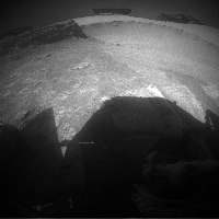
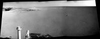
That image just cried out to be made into a 3D, and although it's painfully dark and could be a lot sharper and crisper it just looks so, well, human doesn't it? I know flak has been fired in the past for humanising the rovers, thinking of those chunks of metal, glass and circuit board as something other than just machines, but looking at that shadow stretching off down Duck Bay, almost touching the dune field in the centre of the crater, I get an overwhelming impression of sadness from Oppy... this magnificent crater has been her home for so long... she's watched the Sun wheel around its rim, watched the shadows of the cliffs sweep around her as she's edged ever closer to the foot of Cape Verde... and she was so close, SO close to reaching out and touching it... but now she has to leave without achieving that goal. So like any weary tourist who's run out of time and has to head off to another location she's paused for a moment to drink in the view one last time, looking behind her and remembering what she's achieved and seen inside this amazing, beautiful place, even as she stares at the route ahead, and looks forward to seeing new wonders, and sunsets and sunrises from the world above...
I know... ... but I admit it, I live this stuff, you know!
Posted by: CosmicRocker Aug 10 2008, 07:47 AM
I don't get that impression. I see this machine amazing its creators and controllers, and encouraging them to push it yet, more forward and onward.
This is no time for sadness. It is again, a time for explorations and new discoveries.
Posted by: Stu Aug 10 2008, 07:54 AM
Ok, just me then.
Posted by: djellison Aug 10 2008, 09:43 AM
It's a robot. Much as I love them, you really can take the personification stuff too far.
A robot that's been spending months essentially stuck on sandy slopes, getting a broken arm, symptoms of a broken wheel, unable to really get to the beef of the science in there. Time to get out an do some sprinting? Bring it on.
Doug
Posted by: Stu Aug 10 2008, 09:56 AM
I know it's a robot. It has no heart, no soul, can't think or feel, but it's come to mean something more to me - and to many people here, I'm sure - than just a chassis crammed with circuit boards and instruments.
Some of us here are engineers and techs, some of us are poets and dreamers. The MER mission has touched us all in different ways. Some have been inspired by the technology, others in the scenery. Me, I've been inspired by the journey, and a stage of that journey is coming to an end. So apologies for attributing feelings to Oppy that obviously can't be there, but it's quite an emotional image that, I think. More than just a shadow on a rocky slope. To me, anyway.
Posted by: BrianL Aug 10 2008, 02:17 PM
Stu, I think your comments are spot on. Not for the rovers themselves, obviously, but for the many people who have worked so hard to build and operate these devices. The rovers are the physical extensions of these people, who can feel all these things. Or, to use a religious analogy, the body is on Mars, but the soul is here on Earth.
Keep bringing that humanizing element to this forum, Stu. We can't all be scientists, but we can all be entranced by the wonder of it all.
Posted by: ilbasso Aug 10 2008, 04:00 PM
I think the personification is a projection of our own feelings and emotions onto the rovers. It's a natural and human thing to do. The rovers are physical devices created by us, and as such are projections of our minds and hands and bodies onto another world. Why shouldn't we also project our emotions there as well?
Think of the collective will, the fears, the hopes, the wishes of all the people who created these wonderful devices...and then think about how much time we in the UMSF community have collectively spent looking over the shoulders of these robots these past 4 years. That's probably millions of hours spent "living" with Spirit and Oppy. That's a big investment in psychic energy we have made in them!
I feel confident stating that we would not be imparting "feelings" to Spirit and Oppy if they did not have cameras on them. We can't identify with sensors. The photos make us see these rovers in a REAL place.
I also think the mobility aspect makes them somewhat easier for us to identify with, too. For example, I haven't heard much personification going on about Phoenix. We liked Sojourner and called it cute, but we never said the same thing about the Pathfinder lander. (Do we think of the rovers as "pets"?) We like the probes that can reach out and touch things, but again the identification is increased if the probe can move around to get into position.
I have seen some imparting of emotion to space probes (I remember Time Magazine calling Pioneer 10 "plucky"), but again we don't invest them with the same identification as we do the rovers - maybe because they're not sharing our vantage point of 1.75 meters above the ground.
So my opinion is that it's the combination of cameras, mobility, longevity, interacting with the environment, and seeing things from a human point of view that makes us see Spirit and Oppy as friends, fellow travelers on incredible journeys.
Posted by: Tman Aug 10 2008, 04:56 PM
Agree mostly! It's like the love to your car that brings you to (new) destinations too.
Tried to adjust the cloud GIF with an inverted sky image. It's 600kb http://www.greuti.ch/oppy/clouds.gif
Posted by: djellison Aug 10 2008, 06:15 PM
See - thats our emotions projected upon a robot - that makes sense. One might feel sadness FOR Opportunity at leaving Victoria crater (I feel the opposite), but the vehicle itself does not That's the differentiation of lexicon that makes it make sense.
Doug
Posted by: centsworth_II Aug 10 2008, 07:44 PM
So you also are a member of the UMSF semantics club?
Posted by: Sunspot Aug 10 2008, 07:51 PM
http://qt.exploratorium.edu/mars/opportunity/forward_hazcam/2008-08-10/1F271648925EFF90EHP1214L0M1.JPG
Posted by: Tman Aug 10 2008, 08:15 PM
Hmm, the new tracks from the last drive are odd. Hope this slide of the left front wheel is only due to the (particular) slippage of the left rear wheel.
Posted by: BrianL Aug 10 2008, 08:19 PM
I'm also not sad to be heading out. To be honest, as much as I was relieved to get out of those potentially rover swallowing dunes when Oppy first hit the apron, I find myself missing the almost daily tension that accompanied that journey. I'm looking forward to new sights, new adventures as she makes her way... sorry, as it makes its way to places unknown. Ithaca
Edit: Tman, I'm not quite ready for that tension just yet.
Posted by: Tman Aug 10 2008, 08:33 PM
I'm not yet too...
Posted by: CosmicRocker Aug 11 2008, 04:43 AM
I'm going to have to learn how to do that.
Posted by: Tman Aug 11 2008, 12:41 PM
It's no wizardry - is that a common term in English too? - with PhotoShop.
A cloudless sky image, that comes the exposure/illumination of the cloud image as close as possible, has to be inverted (whitish comes blackish and blackish comes whitish). Then this inverted sky image has to cover up as layer 1 the cloud image with (here) 40 percent. Then you may working additionally some adjustments for better contrast of the clouds.
Posted by: Tesheiner Aug 11 2008, 02:18 PM
You know, I should be at the beach or at the swimming pool right now, but here I'm "stealing" the kids' notebook in between "torrent" movies.
Posted by: Oersted Aug 11 2008, 09:58 PM
I'm sad to see Oppy back off from the rock wall, because I think it would have accomplished more science there than it will by heading off now.
I hope I'm wrong!
Posted by: CosmicRocker Aug 12 2008, 04:35 AM
- with PhotoShop. ...Edit: That's one of the things I like best about this forum. There are all kinds of damn wizards hanging around here.
Posted by: Zeke4ther Aug 12 2008, 05:08 AM
As are you.
Posted by: Tman Aug 12 2008, 08:06 PM

|
Posted by: Tman Aug 12 2008, 08:56 PM
Yeah she drives http://qt.exploratorium.edu/mars/opportunity/forward_hazcam/2008-08-12/1F271824790EFF90FDP1213R0M1.JPG
Posted by: akuo Aug 12 2008, 09:24 PM
Quite striking view on the navcam: http://qt.exploratorium.edu/mars/opportunity/navcam/2008-08-12/1N271825309EFF90FDP1997R0M1.JPG
I don't see why the lower part of the image is so much lighter. It seems to be a real feature of the ground and not some optical effect of the came, as visible on http://qt.exploratorium.edu/mars/opportunity/navcam/2008-08-12/1N271825093EFF90FDP1997R0M1.JPG
Posted by: fredk Aug 12 2008, 09:35 PM
In both the images you linked to it's the same optical effect causing the lighter areas. With the steep slope we're often looking into the sun on these shots and we're seeing some glare onto the camera. The two images overlap a bit, and in one frame the overlapped region is light and in the other it's dark, so it can't be real surface brightness.
Posted by: Tman Aug 12 2008, 09:40 PM
There's another angle of this illumination http://qt.exploratorium.edu/mars/opportunity/navcam/2008-08-11/1N271649704EFF90EHP1997R0M1.JPG
Maybe a mirror effect from an optic part that causes some mixup in the exposure.
Posted by: akuo Aug 12 2008, 09:44 PM
OK, it's clearly an optical effect then. I haven't seen it so clear in navcam images before.
Posted by: Sunspot Aug 13 2008, 10:48 PM
 http://qt.exploratorium.edu/mars/opportunity/rear_hazcam/2008-08-13/1R271925415EFF90GBP1314R0M1.JPG
Posted by: Stu Aug 13 2008, 11:04 PM
Beautiful...

|
Posted by: imipak Aug 13 2008, 11:10 PM
<keanu> woah! </keanu> Fabulous anaglyph too Stu. Is it my imagination or are they edging steadily closer to the lowest possible angle of incident sunlight falling on the slope, ie just the upper relief from the slope illuminated? There seem to have been a lot of similarly framed and timed shots of late.
...and I wonder what the cost per sol number's down to now?
Posted by: akuo Aug 13 2008, 11:18 PM
I wonder if that shadow shot was timed and planned :-)
Posted by: jamescanvin Aug 14 2008, 07:27 AM
I would say yes.
The normal end of drive hazcams were taken as planned at 13:00 LST
01619 13:03:46 p1313.02. 1 0 3 2 0 2 2 rear_haz_ultimate_3bpp_pri15
Then hours later at 16:35LST another rear hazcam shot was taken, and taken at a higher quality.
I can see no need for that apart from for coolness.
Posted by: Tman Aug 14 2008, 12:27 PM
Once Opportunity is back on the rim, it would be so cool to capture a movie-like sequence of the rising shadows in Victoria with the Navcam or a Hazcam - just to say goodbye.
Could it be possible regarding power level or capturing in more than one/two sol?
Posted by: djellison Aug 14 2008, 01:01 PM
For approx $20m/year, you get about 710 sols (355, twice ) - about $28,200 per rover per sol.
The orig 90 x 2 sols for approx $850m was about $4.7m per rover per sol
Posted by: nprev Aug 14 2008, 01:38 PM
Just by way of comparison, the cost of a full fuel load for a heavy jetliner (747, 777, etc.) is right now around $166,000. That's a bit more than 50% of operating costs for a day considering labor, etc. So, the bottom line is that the amortized costs of running the rovers this long are comparable to that of running a very small (two-ship fleet) regional airline; what a great deal for the taxpayers!!!
Posted by: Ant103 Aug 14 2008, 03:41 PM
Two parts of a panoramic taken on Sol 1613.
http://www.db-prods.net/blog/wp-content/uploads/2008/08/sol1613-pano-part1.jpg
And a "pseudo-fisheye" view of the escape path (I imagine )
http://www.db-prods.net/blog/wp-content/uploads/2008/08/sol1613-pano-part2.jpg
Posted by: fredk Aug 15 2008, 03:02 AM
Sorry to be all engineering-minded here, but I thought those images were to get better lighting around the rear wheels. In the afternoon they're in shadows and it can be hard to make anything out.
But I sure love the images!
Posted by: lyford Aug 15 2008, 03:57 AM
Less per sol than a http://www.bloggingstocks.com/2007/10/10/the-most-expensive-hotel-room-in-nyc/
And better views, too
Posted by: jamescanvin Aug 15 2008, 07:29 AM
Well maybe.
But I would have thought a longer exposure while the wheels were in shadow would have been better than doing that if it were needed. Then you would have a nice diffuse illumination with no shadows of the wheel itself obscuring part of the ground.
Posted by: Tman Aug 15 2008, 08:24 AM
Guess you mean rather those http://qt.exploratorium.edu/mars/opportunity/rear_hazcam/2008-08-06/1R271306561EFF90DCP1314R0M2.JPG
Posted by: Sunspot Aug 15 2008, 10:44 PM
The front wheels appear to be on solid rock once again.
http://qt.exploratorium.edu/mars/opportunity/forward_hazcam/2008-08-15/1F272093758EFF90IEP1212L0M1.JPG

Posted by: peter59 Aug 18 2008, 07:24 AM
Sol 1623 - little progress, but progress! 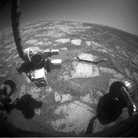
Posted by: BrianL Aug 18 2008, 01:44 PM
Where are you finding those images? The exploratorium URL's that I have are still only up to sol 1621.
Brian
Posted by: jamescanvin Aug 18 2008, 02:47 PM
As they are 200x200 pixels they must be from the Pancam Data Tracking site. Nice work keeping us updated Peter.
Posted by: ddeerrff Aug 19 2008, 02:48 AM
Which wheel is it that gave them problems on Oppy? As they begin to make their way out of Victoria, has that wheel motor been behaving itself?
Posted by: Tman Aug 19 2008, 11:20 AM
It's the left front wheel that got a current spike. So far it looks like it works still fine!
Posted by: BrianL Aug 19 2008, 12:19 PM
Nooooooo!!!!!!
Touch wood, throw some salt, and please refer to it as The Scottish Wheel in the future.
Posted by: centsworth_II Aug 19 2008, 01:29 PM
Or, should we advise Opportunity to "break a wheel"?
Posted by: ddeerrff Aug 19 2008, 04:40 PM
Thanks Tman
Posted by: ustrax Aug 19 2008, 07:17 PM
I don't know if made mention to this already but the crater where Oppy is headed is NOT Erebus, just got an email from SS clearing that point:
"Is the "not yet named" crater referenced (on the TPS blog) here Erebus?
No... it's a different crater, very subdued topographically, but visible in MOC and HiRISE data. We have not made the decision on where to go yet, but it is a leading candidate."
I'm sure you guys can spot it...
Posted by: Reckless Aug 19 2008, 09:07 PM
OOPs removed my own post for silly suggestion Sorry
Posted by: akuo Aug 19 2008, 09:11 PM
Are you kidding? That's Endurance.
Posted by: Reckless Aug 19 2008, 09:14 PM
See above a moment of madness
Posted by: Reckless Aug 19 2008, 09:19 PM
So is it the crater that Erebus is embedded in?
Posted by: stevesliva Aug 19 2008, 10:11 PM
Good MOC context image here:
http://www.msss.com/moc_gallery/r10_r15/images/R15/R1500822.html
The route context image is a bit cropped in that direction:
http://www.msss.com/moc_gallery/r22_s04/images/R22/R2200640.html
Or Hirise, upside down (use "full image")
http://hirise.lpl.arizona.edu/PSP_004289_1780
http://hirise.lpl.arizona.edu/TRA_000873_1780
Posted by: peter59 Aug 20 2008, 07:53 AM
Sol 1625
Next successful drive.


Posted by: djellison Aug 20 2008, 09:19 AM
That's a very succesfull drive - I'll have to send some kudos to Paolo for that!
D
Posted by: Philotas Aug 21 2008, 03:50 PM
Ah, not sure where I should post this, but an image (a pretty decent one I should say) from Opportunity created by an UMSF user was used in a http://www.space.com/scienceastronomy/080820-mars-ice-clouds.htmlarticle yesterday.
Just thought I should mention.
Posted by: Pertinax Aug 21 2008, 04:29 PM
Funny, I just rediscovered that image on my HD two days ago while collecting interesting mars images for 2008 (thus far). Having been one of the world's worst weather observers I have a special place in my heart for landscapes with clouds.
-- Pertinax
Posted by: mhoward Aug 22 2008, 12:18 AM
Heh. They've used that image on space.com before, in fact I think it's popped up elsewhere as well. Someday when I have spare time I'd like to do a QuickTime VR version of that scene using the PDS IMG files... but I'd have no idea how to colorize it, or fill in the gap between the horizon and the sky.
(Adding: and if you don't know the story of http://apod.nasa.gov/apod/ap061017.html, it was actually an http://www.unmannedspaceflight.com/index.php?showtopic=3324 between several people on this forum, myself included.)
Posted by: alan Aug 22 2008, 12:27 AM
Will it be tosol?
01627 p1212.09 0 0 0 0 0 0 front_haz_ultimate_2_bpp_pri15
01627 p1314.00 0 0 0 0 0 0 rear_haz_ultimate_4bpp_pri15
01627 p1981.24 0 0 0 0 0 0 navcam_2x1_rvraz_0_1_bpp
01627 p1994.03 0 0 0 0 0 0 nav_1x1_VictoriaEgress_Leye_1bpp_pri72
Posted by: Philotas Aug 22 2008, 08:08 AM
(Adding: and if you don't know the story of http://apod.nasa.gov/apod/ap061017.html, it was actually an http://www.unmannedspaceflight.com/index.php?showtopic=3324 between several people on this forum, myself included.)
Hehe! The usage in the SPACE.com article doesn't matter that much then.
Anyhow, great work and thanks for the info.
Posted by: Tman Aug 22 2008, 12:15 PM
Oops, didn't see the missing pics came in days ago:
960kb: http://www.greuti.ch/oppy/clouds4.gif
Additionally the visibility of the clouds is improved without too excessive contrast, I think.
Posted by: Ipparchus Aug 23 2008, 09:17 AM
Did Oppy exit Victoria? if not, then how many sols should we wait? have you got any new photos(after Sol1625)?

|
Posted by: djellison Aug 23 2008, 10:07 AM
There are problems with the pipe that chucks the raw imagery online at the moment. There were some post-drive images on 1627 commanded, but not yet downlinked. Not sure about 1626, and 1625 is online.
Posted by: jamescanvin Aug 23 2008, 10:09 AM
No, the latest for sol 1628 shows we're at the same site as on sol 1625.
Looks to me like there was supposed to be a drive on sol 1627 but it didn't happen, I don't know if that was aborted or if there was a change of plan (or if I've misread the database).
The next drive is planned for sol 1630. I'd be surprised if Oppy exited Victoria on this drive, I would imagine they will get close to the top before having a short drive across the lip.
Three more drives, out by next weekend if I had to guess.
James
Posted by: charborob Aug 25 2008, 01:36 AM
Nobody seems to have noticed that on sol 1620, Opportunity had been at Victoria crater for one full Mars year! Keep going, Oppy!
Posted by: peter59 Aug 25 2008, 07:23 AM
Sol 1630 - successful drive ! 


Posted by: Tman Aug 25 2008, 11:47 AM
Definitely the same way out as in:
In: http://marsrovers.jpl.nasa.gov/gallery/all/1/r/1298/1R243418667EFF86KRP1305L0M1.HTML
Out:

Posted by: jamescanvin Aug 25 2008, 02:10 PM
Yes, if you look at the top-left of the centre image peter59 posted you can see the tracks across the rim dune from the entry.
Seems like yesterday.
Posted by: Stu Aug 25 2008, 03:00 PM
I made and posted this a year ago... seems appropriate to post it again as Oppy prepares to drive out of Victoria Crater...

|
Posted by: climber Aug 25 2008, 04:00 PM
I guess they choose to use the entry path to get out and to avoid any inconvenience in crossing the dune...
Yes, it looks like yestersol.
Posted by: CosmicRocker Aug 26 2008, 03:52 AM
Well, that's not really a surprise, is it? They originally chose this spot as the safest way in and out of the crater. Then they did the "toe dip" and backed out to prove they could exit before going deeper. They had proof-positive that Opportunity could climb out here without difficulty. Unless they had been able to drive inside the crater to a different bay, this was almost guaranteed to be the exit point.
Posted by: alan Aug 27 2008, 07:11 AM
Almost
Posted by: Astro0 Aug 27 2008, 07:15 AM
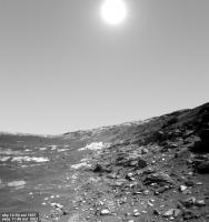
I'm actually excited to see the annulus again!
Flat...featureless...safe.
Roll on Opportunity, new horizons await.
Astro0
Posted by: alan Aug 27 2008, 07:44 AM
comparing the brightened rear hazcam view
to the images from the toedip
http://marsrovers.jpl.nasa.gov/gallery/all/opportunity_r1291.html
the rear wheels are just below the lip
http://marsrovers.jpl.nasa.gov/gallery/all/1/r/1291/1R242799174EFF86IEP1325R0M1.HTML
Posted by: Stu Aug 27 2008, 01:39 PM
http://www.spaceweather.com
Posted by: Stu Aug 27 2008, 02:20 PM
So close... so close...

|
Bet yes, time to move on... Wonder await, Oppy!
Posted by: climber Aug 27 2008, 03:38 PM
Is that the Beacon on the &@%¤ side of Vicky that starts to show in Stu's view?
Posted by: ElkGroveDan Aug 27 2008, 03:44 PM
Flat...featureless...safe.
Not if they are headed over to the region around Erebus again.
Posted by: centsworth_II Aug 27 2008, 06:24 PM
Even if it's to a never-before-seen unnamed crater?
Posted by: ElkGroveDan Aug 27 2008, 06:33 PM
Anything to the north is covered with large dunes until you get back up past Viking and Voyager craters.
Posted by: SpaceListener Aug 27 2008, 07:30 PM
As far as I have heard that the next Opportunity mission would be in looking for any cobblers on the way? Indeed, the during search way would be toward to Erebus crater?
Posted by: centsworth_II Aug 27 2008, 07:50 PM
Remember the Steve Squires hint, and Ustrax challenge:
"Is the "not yet named" crater referenced (on the TPS blog) here Erebus?
No... it's a different crater, very subdued topographically, but visible in MOC and HiRISE data. We have not made the decision on where to go yet, but it is a leading candidate."
I'm sure you guys can spot it...
There are some very subdued craters in the area. I wonder if it's one of those.
|
http://www.nasa.gov/mission_pages/mer/070628/pia09691.html
Posted by: ElkGroveDan Aug 27 2008, 08:11 PM
Well my original point still stands, anything in those directions would involve the old sand dune zig-zag.
But it brings up another point. What the heck is there to investigate in those subdued craters? At least Erebus had some outcrops and rock exposures to examine. But I can't see the point of going to what amounts to a very large Viking Vostok Crater. (But I'm sure they have some goals in mind that we will soon be made aware of.)
EDITED
Posted by: bugs_ Aug 27 2008, 09:12 PM
Maybe someone spotted something interesting in an MRO image.
Posted by: alan Aug 27 2008, 09:28 PM
Oppy's going to run away without taking a closer look at the other 2/3 of Victoria's rim?
Posted by: Tman Aug 27 2008, 10:18 PM
And Oppy! Please do not forget to capture a "complete" image row of the rising shadows in Victoria before you leave!
Posted by: ngunn Aug 27 2008, 10:39 PM
That's what I find surprising too.
Posted by: djellison Aug 28 2008, 07:19 AM
I think they're going to go south and look at more rim.
But exploring the entire rim in the same detail we have done so far would be a 2 year long process, and at some point it just becomes stamp-collecting rather than science.
Posted by: climber Aug 28 2008, 07:46 AM
Yes, I think we'll gain another perspective of Duck bay (at least) which could help to understand the whole story
Posted by: climber Aug 28 2008, 07:48 AM
I love when one write both the question and the answer
Posted by: Phil Stooke Aug 28 2008, 03:27 PM
The hope must be that they expose different layers in the stratigraphic column.
But look out beyond the big crater WNW of Victoria - there are other features beyond it (plus various cobbles en route, no doubt). A cluster of small fresh impact craters (probably secondaries, and so maybe accompanied by exotic ejecta), and eventually a spectacular crater that looks more promising than Victoria as a possible long term goal. So there's a longer term goal, and intermediate steps with a possibility of new exposures. There's no way I'd want to go back to Erebus.
Phil
Posted by: briv1016 Aug 28 2008, 03:32 PM
Is anyone else having trouble getting the latest Exploatorium update to load onto Midnight Mars Browser?
Posted by: djellison Aug 28 2008, 04:54 PM
yes.
Posted by: PDP8E Aug 28 2008, 06:44 PM
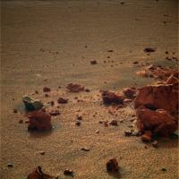
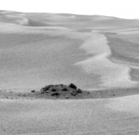
I think the team is looking for these...cobbles... (sol 658?)
|
Posted by: BrianL Aug 28 2008, 06:58 PM
If you are talking about that big one two "endurances" due west, it does look very appealing. The slopes appear (admittedly to my untrained eye) drivable to a deeper level. However, with the strong possibility of an impending wheel lockup, I've pretty much put long term (at least, long distance) goals out of my mind.
Posted by: Stu Aug 28 2008, 07:34 PM
Almost there... almost there...

|
Posted by: PaulM Aug 28 2008, 07:53 PM
I think that it might be possible to send Oppy far further than anyone imagines.
My reason for thinking this is that Oppy originally covered the 3024 m between the heatshield (SOL 359) and Voyager crater (SOL 432) in only 73 SOLs. In this period Oppy travelled on average 41.43 m per day. This included stopping off from time to time at interesting locations such as Vostok crater. On driving days Oppy covered up to 140 m. If my maths is correct this means that Oppy might be expected to drive 15 km per year across the easy driving terrain around Endurance crater.
I expect Oppy to take at least 6 months to traverse the dunes of the etched terrain again. However in 2.5 years time I expect Oppy to be 35 km North of Victoria crater. I believe that this is the distance that one of the Lunakhod rovers drove on the Moon in just a few months.
I wonder if Oppy could reach the clays below the gypsum rich sandstones it is currently driving upon if it was to drive 35km North of its current location? I wonder how far the potential MSL North Merridiani landing site is from Victoria crater?
I realise of course that the problem is that one of Oppy's wheels if likely to fail long before the 2.5 years have passed. However I hope that MSL's wheels are stronger than MER's wheels and that MSL will be able to drive 200+ km in the 10 years that MSL is likely to survive on Mars.
Posted by: centsworth_II Aug 28 2008, 08:18 PM

|
That's the pile just off the Northwest edge of Erebus, right? I was surprised and disappointed when they drove on without checking that pile out. But if Opportunity is not going back to Erebus, it is not going back to that mother load of cobbles.
Posted by: climber Aug 28 2008, 08:38 PM
PaulM, you may want to contact Ustrax to create an OLD (Oppy Long Distance) association.
I didn't thought anyone could have challenged Oppy's driving capabilities more than Rui, but you did
BTW, I'm with you but following waaaaaay behind
Posted by: PaulM Aug 28 2008, 08:52 PM
I didn't thought anyone could have challenged Oppy's driving capabilities more than Rui, but you did
BTW, I'm with you but following waaaaaay behind
The problem in attempting to reach Ithaca crater is the dunes, not the distance. It would be much easier to travel the same distance to the North across a parking lot. Even if there is no obvious target to the North it would still be worth travelling North to sample steadily lower strata in the Merridiani's 700m thick stack of gypsum rich sandstones.
Posted by: hortonheardawho Aug 28 2008, 08:57 PM
sol 1632@16:13 LST OUT!
http://www.flickr.com/photos/hortonheardawho/2806187819/
I think Oppy pulled a fast one and did 2 drives on 1632.
Posted by: djellison Aug 28 2008, 09:28 PM
Almost certainly unrealistic. Nothing like optimism, but please don't do the 'X metres per sol x Y months = Z kilometres'. It only ever worked once - when Spirit went from Bonneville to Pot-of-Gold in 45 sols.
Posted by: jmjawors Aug 28 2008, 09:29 PM
http://www.flickr.com/photos/hortonheardawho/2806187819/
I think Oppy pulled a fast one and did 2 drives on 1632.
Are you sure? Aren't those the entrance tracks?
Posted by: BrianL Aug 28 2008, 09:38 PM
Oppy is still clearly on the inside looking out. But it is nice to see into the distance again. Getting a might claustrophobic in that darn hole.
Posted by: Astro0 Aug 28 2008, 10:28 PM
There's some really nice views coming from Oppy as she clears out the memory before heading back on to the plains of Meridiani.

|
Astro0
Posted by: hortonheardawho Aug 28 2008, 11:08 PM
DOH!
I wondered why the "inside" of Victoria was so smooth!
Posted by: Astro0 Aug 28 2008, 11:17 PM
Another nice view in subdued light.

|
Astro0
Posted by: peter59 Aug 29 2008, 08:10 AM
Goodbye Victoria.

http://qt.exploratorium.edu/mars/opportunity/forward_hazcam/2008-08-29/1F273250045EFF90O4P1212R0M1.JPG
Posted by: Astro0 Aug 29 2008, 12:14 PM
Wow. I'm kinda sad now that we've left Viccy behind.
Hey Stu, there's has to be a poem coming soon, eh?!
Astro0
Posted by: Tman Aug 29 2008, 12:52 PM
Don't think we already left it. That was just the drive out so far.
Posted by: djellison Aug 29 2008, 01:08 PM
No - we're properly out of it now.
Posted by: Stu Aug 29 2008, 01:12 PM
I'm kinda sad now that we've left Viccy behind.Hey Stu, there's has to be a poem coming soon, eh?!
Well, at the risk of coming over as a rover-hugging over-sentimental kaftan-wearing melodramatacist, I'm sad too... it was a heck of an adventure getting to and then into Victoria, one none of us here will ever forget... but Oppy has work to do elsewhere, and who knows what fascinating new sights she'll see? There'll be more dust storms to endure, more glitches to overcome, more challenges to face, I'm sure, but our gal will keep going until the last weary whirr of her wheels.
A poem? Hmmm. Ya think..?
Posted by: ilbasso Aug 29 2008, 01:49 PM
When we finally sing the Song of Opportunity after its journey, we'll need a canto for each of its adventures...The Hole in One, Leaving the Nest, Endurance, The Heat Shield, The Journey South, The Dunes of Erebus, The Slopes of Victoria, Ithaca...
Posted by: hortonheardawho Aug 29 2008, 01:55 PM
er, now?
http://www.flickr.com/photos/hortonheardawho/2807899849/
Posted by: BrianL Aug 29 2008, 02:31 PM
http://nasa.exploratorium.edu/mars/opportunity/navcam/2008-08-29/1N273249874EFF90NVP1937R0M1.JPG
I find this a very poignant shot. Reminds me of when Oppy first arrived and we filled the swear jar.
nostalgic pause
OK, time to move on! Woo-hoo!
Posted by: Stu Aug 29 2008, 04:02 PM
Farewell Victoria...

|
( full size version http://phoenixpics.wordpress.com/2008/08/29/farewell-victoria)
Posted by: belleraphon1 Aug 29 2008, 09:28 PM
Six wheels on level powder...
Boo Hoo and Woo Hoo
Travel on, little rover, travel on...... we are with you.
Craig
Posted by: CosmicRocker Aug 30 2008, 05:44 AM
belleraphon1: Of all the "exit and move on" comments I've read so far, yours was my favorite and the most http://www.google.com/search?q=define%3Asuccinct at this point in time.
I have little to add. Let's get on with it... (Is it only me, or does that wheel appear to be rotating in reverse?)
Posted by: Ant103 Aug 30 2008, 02:43 PM
I'm not so nostalgic to leave Victoria's inside. But, when the rover will definitively leave the crater, yes, I will feel more nostalgic (like when the rover reach out of Eagle Crater, it was like to leave a sort of home).
Last color view of the track and rocks at Sol 1618 :
http://www.db-prods.net/blog/wp-content/uploads/2008/08/sol1618-tracksrocksanddisturbedsoil.jpg
Posted by: Stu Aug 31 2008, 12:06 AM
Think Oppy will take a closer look at these "cobbles", scooted past in April 2007..?

|
Posted by: Shaka Aug 31 2008, 01:30 AM
Those are well off the intended NNW track, aren't they? Way over to the east.
Posted by: fredk Aug 31 2008, 01:57 AM
From http://space.newscientist.com/article/dn14632-mars-rover-clambers-out-of-victoria-crater.html
Alternatively, mission planners may decide to send the rover south of Victoria Crater.... to a "huge" crater that lies 15 kilometres south of Victoria
Posted by: BrianL Aug 31 2008, 04:16 AM
Huge crater? Is there a huge crater to the south? Has anyone noticed this before?
Oh man, is that going to set somebody off!
Posted by: Stu Aug 31 2008, 06:47 AM
Yep, but intentions can change. Just wondering...
Posted by: djellison Aug 31 2008, 09:19 AM
Oh boy. I'm looking forward to AJSR's update tomorrow
I hope they can do a 'done with Victoria' press conf.
Doug
Posted by: Gonzz Aug 31 2008, 04:01 PM
Oh man, is that going to set somebody off!
You bet hehe, I live in Lisbon and I think we can just hear him shouting with Joy way way over there in Sintra
Posted by: Floyd Sep 1 2008, 12:12 AM
Well, since Opportunity has left Victoria Crater, it is time for a new thread.
http://www.unmannedspaceflight.com/index.php?showtopic=5431&pid=124880&st=0&#entry124880
Posted by: jamescanvin Sep 1 2008, 07:15 AM
http://www.planetary.org/news/2008/0831_The_Mars_Exploration_Rovers_Update.html
Posted by: ElkGroveDan Sep 1 2008, 03:20 PM
Well hey now here's some good news:
Posted by: Stu Sep 1 2008, 04:00 PM
Gulp...
That's actually http://img.photobucket.com/albums/v509/cumbriansky/lookingback2.jpg, isn''t it..?
Posted by: mhoward Sep 1 2008, 04:06 PM
I couldn't resist doing a http://mmb.unmannedspaceflight.com/OpportunitySol1637Navcam.mov (2.7 MB)
Posted by: Ant103 Sep 1 2008, 04:16 PM
You couldn't resist Micheal
and you're right. Your VR is great .
In the same time, I've produced the panoramic :
http://www.db-prods.net/blog/wp-content/uploads/2008/09/sol1637-leavingvictoria.jpg
Posted by: Stu Sep 1 2008, 04:17 PM
Brilliant, thanks Mike!
Posted by: mhoward Sep 1 2008, 04:24 PM
Also, here's a postcard of virtual Opportunity exiting the crater. Maybe somebody can produce a more refined version.
http://www.flickr.com/photos/marscat/2817397547/sizes/l/
Posted by: Tesheiner Sep 1 2008, 09:06 PM
Sol 1637: Positioning the rover before taking a last panorama from Victoria?
http://qt.exploratorium.edu/mars/opportunity/forward_hazcam/2008-09-01/1F273511017EFF90OYP1214R0M1.JPG
And have a look to this collection of tracks from now, one year ago and two years ago!
http://qt.exploratorium.edu/mars/opportunity/rear_hazcam/2008-09-01/1R273510966EFF90OYP1312R0M1.JPG


Posted by: ilbasso Sep 1 2008, 11:24 PM
It's quite a shock to see the tracks of those long, straight drives again!
Posted by: Astro0 Sep 2 2008, 12:34 AM
AN OPEN "PLEASE, OH PLEASE!" To Steve Squyres and the Rover driving team.
Before you head off on the Cobble Road, could we please have one relatively short drive to Cabo Frio.
Give 'Sputnik' a quick glance on the way and then take Opportunity out onto that promontory.
Just for that chance to take a look back at Cape Verde, Duck Bay and back along the crater rim that Opportunity drove along.
PLEASE, OH PLEASE!
Astro0
Posted by: Shaka Sep 2 2008, 12:47 AM
tourist
Posted by: brellis Sep 2 2008, 02:05 AM
This normally quiet lurker has a few questions as Opportunity leaves Victoria crater. I'm going to try to answer them via Google.
How deep did Opportunity make it into Victoria? How old are the formations at Cabo Verde? From this http://space.newscientist.com/article/dn13775 on the shoulder problem:
The rover had just come from studying rock layers exposed within the crater walls, including one particularly eye-catching band that formed a bright "bathtub ring" around the crater's inside.
But despite driving more than 40 metres down into the crater – representing a vertical depth of about 8 metres – Opportunity spotted nothing but the same type of sulphate sandstone that it had seen everywhere else on its journey, Banerdt says.
Even layers of different colours appeared only to have either a courser or smoother texture that reflected light differently. Still, scientists are now studying the spectrometry data to learn if the layers also contain minute chemical differences that would reveal clues about the region's ancient history.
"There's all kind of pieces to this puzzle, and there's a lot of them that haven't clicked into place yet," Banerdt says.
Scientists have learned from looking at the crater walls that hundreds of millions or even billions of years ago the area was an active dune field, with winds moving either north to south, or south to north – much as they do now.
How deep is Victoria crater? 70m, according to the http://en.wikipedia.org/wiki/Victoria_Crater
My questions for more informed UMSF members: how deep did we get? From AJSR's report:
That would imply about 9 or 10 meters deep into the 70m crater.
Was the "Bathtub ring" all the confirmation Squyres et al needed to confirm the relationship between Victoria and Endurance?
Thanks
Posted by: CosmicRocker Sep 2 2008, 04:43 AM
brellis: Comparing Opportunity's deepest excursion from Tesheiner's route map to the http://marsrovers.jpl.nasa.gov/mission/tm-opportunity/opportunity-sol1272.html, it appears that Opportunity roved approximately 8 meters vertically below the rim of Duck Bay. The 70 meter total depth looks about right, too. The contour lines on that map are 2 meters apart.
Regarding the infamous "bathtub ring," that's a longer story, and there is not a simple answer to that very good question. The term "bathtub ring" has been used numerous times in different contexts by team members and science news writers. It has not always referred to the bright band of rocks seen around the circumference of Victoria. IIRC, the term was first used by Steve Squyres to describe a geochemical horizon the team was looking for when Oppy first approached the crater...the upper extent of the blueberries (hematite concretions) in the sulphate cemented sands. The term was later used to describe other approximately horizontal layers or boundaries that potentially intersect the hole in the ground that we know as Victoria, and which might prove to link the observations made at Endurance Crater to observations made at at Victoria.
We've seen some rather provocative similarities in the rocks from both craters, but also some differences. An important piece of the puzzle are the geochemical gradients in Victoria, which we know little about. I would expect some news in that regard to come out in the LPSC abstracts this spring.
Posted by: brellis Sep 2 2008, 06:14 AM
Thanks for the schooling, Cos.
How much is known about the deeper layers inside Victoria? Was it determined previous to the wheel zap that the potential returns
would diminish below the 8-meter level? Or, have we left behind some unsolved mysteries in the depths of Victoria?
I ask all this as a http://www.unmannedspaceflight.com/index.php?showtopic=3215&hl=ithaca fan. I love seeing Oppy back out in the open field, and I'd love to see her go much farther across the plains, reaching another impressive target.
EDIT: rereading the Big Crater thread, I noticed that our fearless Administrator djellison made a pretty solid prediction in http://www.unmannedspaceflight.com/index.php?s=&showtopic=3215&view=findpost&p=69016
Posted by: Tman Sep 2 2008, 06:40 AM
The most natural scientists sit down every now and then and enjoy - especially when they've become astronauts.
Posted by: Ant103 Sep 2 2008, 03:31 PM
I have made a movie of Sol 1630 pictures taken by the navcam during the escape from Victoria. I think there will be more image to come.
http://www.db-prods.net/upload/EscapeFromVictoria-Sol1630.mov
Posted by: ilbasso Sep 2 2008, 04:19 PM
Ant, I like your morphing/interpolation technique for the drive movies!
Posted by: Tman Sep 2 2008, 04:55 PM
And the growing shadow ^ ^
Posted by: Stu Sep 2 2008, 07:24 PM
Hope some of you like this...

|
Posted by: climber Sep 2 2008, 07:57 PM
Thanks Stu, one of my favorite, very close to what I feel.
Well, may be Oppy's will still be roving in those remote days
Posted by: ustrax Sep 2 2008, 08:56 PM
Oh man, is that going to set somebody off!
I am sure there are great cobbles to study on that huge crater...
Quite happy to see Oppy out of the deeps and geting ready to hit the road again!
And...great words Stu...great words...
Posted by: Bobby Sep 2 2008, 09:15 PM
Question for the masses here. If an earthling woman had a baby on Mars. Would the baby be Martian or Earthling???
Also. Does anyone have any overhead images of the area to the south of Victoria??? I want to see what crater
they are talking about that they may venture to?
Posted by: ElkGroveDan Sep 2 2008, 09:38 PM
It depends on who the father is.

|
Posted by: TheChemist Sep 2 2008, 10:18 PM
Quite happy to see Oppy out of the deeps and geting ready to hit the road again!
And...great words Stu...great words...
Edited out for inappropriateness after seeing http://www.unmannedspaceflight.com/index.php?showtopic=3642&view=findpost&p=124985.
Posted by: hortonheardawho Sep 4 2008, 03:07 AM
http://www.flickr.com/photos/hortonheardawho/2825774199/
I tried straightening out the ride and addad a little color.
Posted by: Ant103 Sep 4 2008, 08:25 AM
Actually, it's just a fade effect, but it give a good transition between pictures
.I've updated my movie with adding the latest frames :
http://www.db-prods.net/upload/EscapeFromVictoria-Sol1630.mov
(size about 30 Mo, Quicktime movie)
And I made a panorama from Sol 1634 pics, showing the "complex track" near Duck Bay (it remind me a highway exchanger). We can see at the left the first tracks of Sol 951 arrive to Victoria, the departure from Duck Bay to explore crater rim and the return to this place.
http://www.db-prods.net/blog/wp-content/uploads/2008/09/sol1634-retrouvaillesaveclaplaine.jpg
I've also made a colorized version (with Sol 1614 clouds)
http://www.db-prods.net/blog/wp-content/uploads/2008/09/sol1634-retrouvaillesaveclaplaine-coulversion.jpg
Posted by: Astro0 Sep 4 2008, 10:16 AM
Ant, that last one is REALLY, REALLY nice!
Posted by: Tman Sep 4 2008, 10:17 AM
Great works Ant!
The sol1634 colorized mosaic with that clouds and the bit solar effect from above is really a very nice composition!
The only objection I have is the yellowish tone of the image. If you don't mind I changed it a bit - sadly the contrast of the clouds have slightly decreased:
Whaddayathink?

|
Posted by: Juramike Sep 4 2008, 11:24 AM
Wow! Those are all beautiful.
Seeing three sets of tracks fading into the martian distance...there's a regular jeep trail out there!
Posted by: Ant103 Sep 4 2008, 03:10 PM
Ow! Many thanks .
Tman : you made more realistic image . Very good .
Posted by: Bernard Sep 4 2008, 03:21 PM
Superb picture, fourmi 103
Merci
Posted by: jamescanvin Sep 8 2008, 05:39 PM
Tracks. New, old and older.
http://www.nivnac.co.uk/mer/index.php/opportunity-sol-1643-l257-r123-4-pointin
And now, since Doug has very kindly sent me some 3D glasses (Thanks very much Doug! )
Colour Anaglyph.
http://www.nivnac.co.uk/mer/index.php/opportunity-sol-1643-l257-r123-4-pointin
James
Posted by: ugordan Sep 8 2008, 06:57 PM
Talk about burning... errr... rubber
Great mosaic, James!
Posted by: Stu Sep 8 2008, 08:14 PM
Oh great, James is doing spectacular anaglyphs now, too... I might as well just delete Stereophotomaker from my PC!
Posted by: Tesheiner Sep 9 2008, 11:00 AM
Here're some pictures taken on sol 1643 of Opportunity exercizing the IDD: http://nasa.exploratorium.edu/mars/opportunity/forward_hazcam/2008-09-08/
And the plan for sol 1645 (today) includes a bunch of MIs; that would be the first use of it in months! Actually, since sol 1502.
Posted by: Tesheiner Sep 10 2008, 03:31 PM
First MIs in four months.
http://nasa.exploratorium.edu/mars/opportunity/micro_imager/2008-09-09/
Posted by: ilbasso Sep 10 2008, 05:56 PM
I take it these are views of the old tracks?
Posted by: Floyd Sep 10 2008, 11:39 PM
Tracks from 3 times. From left, 2 years ago when Opportunity first arrived, next this past week, next driving in 1 year ago, next last week again. The tracks from 2 years ago went through the worst of the dust storm and are really degraded. Those from a year ago were after the dust storm and look just a little degraded. (I hope I have this correct--please correct me if I am wrong).
Posted by: ilbasso Sep 11 2008, 12:32 AM
Was asking about the MI's - which set of tracks do you think they were imaging?
Posted by: centsworth_II Sep 11 2008, 01:25 AM
The MIs are not of tracks. It looks to me like they are of the circular impression made when one of the spectrometers is pressed into the surface. I wonder if it's a fresh impression or if they have relocated an old one.
Posted by: Tesheiner Sep 11 2008, 07:20 AM
Fresh one. The IDD is positioned at a sand drift built up on the rim to the right of the entry/exit path.
http://nasa.exploratorium.edu/mars/opportunity/forward_hazcam/2008-09-09/1F274217379EFF90PDP1110L0M1.JPG

Posted by: CosmicRocker Sep 12 2008, 04:19 AM
A series of 6 navcam EDN frames were planned for a sol 1647 cloud movie. They came down recently along with 6 others taken approximately 13 minutes later.
----- -------- --- --- --- --- --- ---- -----------
01647 p1588.03 6 0 6 0 0 12 Unexpected sequence!!!!
01647 p1588.03 6 0 6 0 0 12 navcam_cloud_movie_right_eye_pri_57
I was going to post the movies, but I think someone else will do them better
, so I'll hold off. Posted by: Astro0 Sep 12 2008, 04:50 AM
I'm sure that someone with a nice flatfield for Oppy Navcam images will improve this, but here's both sequences.
Sorry for the slight distortion from the original frame size but you get the idea. oppy1647_clouds.wmv ( 247.67K )
: 580
oppy1647_clouds.wmv ( 247.67K )
: 580
Posted by: CosmicRocker Sep 12 2008, 05:39 AM
Nice. You did a better job of compressing it than I did. My good animation was almost 2 megs. I'd love to know how you did that, but now, we are again preparing to evacuate from another arriving storm. cya, next time...
Posted by: Tman Sep 12 2008, 05:31 PM
Very nice hit Oppy!
Here's my try with it: 800KB http://www.greuti.ch/oppy/1647clouds1.gif
It's the sequence from 12:00:51 to 02:39. The other is more difficult.
Good luck, Tom!
Posted by: CosmicRocker Sep 13 2008, 06:34 AM
Thanks, Tman. We are comfortably away from the hurricane, in central Louisiana, and I am hoping to go home tomorrow. As far as I can tell, the storm is much less intense than the various media are depicting it as. Some of them are interpreting this hurricane's "eye" as the large hole in their radar map. It appears to me that their radar can not penetrate to the center on the storm, hence the hole in their radar. I can't see any "eye" in the satellite imagery. There's a breeze here, and a little rain. The reporters are blowing it out of proportion.
If earier reports are correct, our home was seriously damaged by wind, and then levelled by the storm surge. No way... Stay tuned...this is fun...
Posted by: peter59 Sep 16 2008, 08:15 AM
Beautiful cirrus clouds over Opportunity's landing site (Sol 1651).
http://qt.exploratorium.edu/mars/opportunity/navcam/2008-09-15/1N274747914EDN90RPP1588R0M1.JPG
http://qt.exploratorium.edu/mars/opportunity/navcam/2008-09-15/1N274748032EDN90RPP1588R0M1.JPG
I wait for next beautiful animated GIF.
Posted by: Ant103 Sep 16 2008, 02:52 PM
I have forget to upload an updated version of my movie of Oppy's escape from Victoria. It's done
http://www.db-prods.net/upload/EscapeFromVictoria-Sol1630.mov
Posted by: djellison Sep 16 2008, 03:19 PM
I'll never be able to change the forum skin, because your GENIUS avatar, and lovely drop-shadowed thumbnails are just too damn good!
Doug
Posted by: Tman Sep 16 2008, 06:02 PM
Hey, who's said "it gives the forum some profundity..."? It's really a nice eye-catcher!
Sol1651 cloud movie in "false"color:
http://www.greuti.ch/oppy/1651clouds.gif
What do you think? Could it roughly look like that way?
Posted by: RobertEB Sep 18 2008, 03:10 PM
http://www.db-prods.net/upload/EscapeFromVictoria-Sol1630.mov
Nice!
Posted by: Astro0 Sep 20 2008, 02:24 PM
It looks like they are trying to just push on through this sandy material at VC's rim to get to the light soil patch ahead.
Here's a four camera animation of the wheels digging/driving through.

|
Let's hope they make it out and can get on with driving to Endeavour Crater (EC).
Astro0
Posted by: SFJCody Sep 20 2008, 02:39 PM
It makes me nervous seeing the wheels churning away like that when I think about how many revolutions they will have to make to get to Endeavour.
Posted by: BrianL Sep 20 2008, 03:09 PM
I'm sure there will be times of churning on the way to Endeavour. Lots of ripples and some will be soft and embeddable (new word). I think the driving team has so much experience now in these conditions, they aren't afraid to push things a bit. They've gotten both Oppy and Spirit (with her bum wheel, which could happen to Oppy) out of some pretty nasty jams. Perhaps they are even testing one of the new driving techniques that SS spoke of. No more zigging and zagging around ripples, Oppy will just bull her way through.
Posted by: brellis Sep 21 2008, 01:05 PM
AstroO - great work on those movies.
Now that they're "hitting the gas" wouldn't it be great if they could get Oppy to "peel out" on it's way from Victoria!
Posted by: dilo Sep 21 2008, 02:43 PM
I made this comparison between navcam images of wheel tracks taken now and 1 year ago, almost in the same position... to aid, you see some referring points (d location is tentative):

|
Interesting to see that track degradation is small (consider that farthest tracks are 2 years old!).
Posted by: BrianL Sep 22 2008, 04:18 PM
Any driving plans in the works? Still trying to get to the bright patch? Exiting out?
Posted by: Tesheiner Sep 23 2008, 09:08 AM
> Any driving plans in the works? Still trying to get to the bright patch? Exiting out?
Today (sol 1659). And based on Paolo's comments I would say we are leaving this site.
Posted by: Stu Sep 23 2008, 09:37 PM
Does http://img.photobucket.com/albums/v509/cumbriansky/edge2.jpg bring back any memories, guys..?
And cobbles? You want http://img.photobucket.com/albums/v509/cumbriansky/sept22-pit2.jpg..?
Posted by: Tesheiner Sep 24 2008, 09:12 AM
Ladies and Gentlemen, fasten your seat belts because our trip will start soon. Next stop is, mmm, Sputnik? Cabo Frio?
Navcam mosaic from sol 1659.
|
Posted by: ustrax Sep 24 2008, 09:34 AM
Hoo-rah!!!
Next stop?...
The cobble just ahead...and study it for like...three months...
Posted by: RoverDriver Sep 24 2008, 10:14 AM
|
|
Interesting to see that track degradation is small (consider that farthest tracks are 2 years old!).
D is probably under the deck in the 1286 navcam. I also think that this place is seeing too much traffic. We need to get a traffic light installed.
Paolo
Posted by: RoverDriver Sep 24 2008, 10:22 AM
Today (sol 1659). And based on Paolo's comments I would say we are leaving this site.
1659 has been a good sol on Mars. Yanked Oppy from the ripple and covered about 10m. Yes, I know it is not 100m, but at least we have "proven" that in case of an embedding event she can be out in a single drive. Both because we are near VC rim, and also because we still need to set our minds for really loooong drives it will take some time to see the first 100m drive.
Paolo
Posted by: Oersted Sep 25 2008, 10:18 AM
La lunga crociera ha cominciato! Speriamo di arrivare ben in porto dopo di traversare con successo gli oceani di sabbia....
(Ho vissuto quattro anni a Firenze, é per quello che parlo un po' d'italiano...)
Posted by: Astro0 Sep 25 2008, 11:29 AM
And for anyone without a Babel fish in their ear...
A straight Google translation...
The long cruise has begun! We hope to arrive well into port after successfully navigate the oceans of sand ....
(I lived four years in Florence, is what I speak a little 'd'Italian ...)
Very nice words Oersted.
Posted by: Paolo Amoroso Sep 25 2008, 11:46 AM
Those who do have such a device might be interested in listening to RoverDriver interviewed by the http://astronauticast.forumastronautico.it/?p=25 and http://medialab.sissa.it/mrpod/Members/BERNAGOZZI/su-marte-in-retromarcia/ podcasts, both in Italian, I'm afraid.
The long cruise has begun! We hope to arrive well into port after successfully navigate the oceans of sand ....
(I lived four years in Florence, is what I speak a little 'd'Italian ...)
Very nice words Oersted.
I hope the Italian navigator will land in the new world--will let us know how the natives are. Very nice words indeed, thanks.
Paolo Amoroso
Posted by: Stu Sep 25 2008, 05:28 PM
If Oppy's in an "ocean of sand" (fantastic words, Oersted!) she was in danger of becoming becalmed http://img.photobucket.com/albums/v509/cumbriansky/tracks-sept25.jpg...
Posted by: imipak Sep 25 2008, 07:29 PM
I'm not so sure. It was clearly a deliberate manoeuvre into a deep ripple, so perhaps it was a test of the latest autonomous driving /anti-slip functions? RoverDriver's said there are sure to be "embedding events" out there on the plains in future; 100m worth of driving into the same dune, Purgatory style, would be Bad. Automated backing-out if embedding's detected, perhaps?
Posted by: Stu Sep 25 2008, 07:32 PM
Good point. I'm still glad she turned back tho.
Posted by: RoverDriver Sep 25 2008, 07:46 PM
This was done intentionally. No we are not crazy. There was a pretty compelling IDD target in front of the rover but the excessive slip prevented the rover from getting there (we were about 1.5m short). We knew very well this could have resulted in a mini-embedding event but believed the risk of getting stuck there permanently was very low.
Paolo
Posted by: dilo Sep 26 2008, 08:03 PM
Go Oppy Go!

|
Posted by: climber Sep 26 2008, 09:52 PM
Have you noticed that the little ripples in front of us in dilo's image are visible in the HiRise image of the route map by Eduardo (post 2345) of today?
I'm confident, once the general path will be decided, it should "easy" to navigate using the upcoming HiRise imagery...
So, at this stage, on top of "Go Oppy Go", I'll say "Go UMSF image wizards, Go"...
Posted by: Bobby Sep 27 2008, 04:25 AM
On the Road Again

|
Posted by: Bobby Sep 27 2008, 05:07 AM
So Long Duck Bay. May Oppy's Journeys Lead to Amazing New Discoveries

|
Posted by: Ant103 Sep 27 2008, 10:25 AM
By seeing the long tracks toward Duck Bay, I'm feeling a little nostalgic. Oppy is closing a page of his life and open one other.
The Sputnik crater on Sol 1661 :
http://www.db-prods.net/blog/wp-content/uploads/2008/09/pano-victoria-sputnik-sol1661.jpg
And the same pano but in anaglyph :
http://www.db-prods.net/blog/wp-content/uploads/2008/09/pano-victoria-sputnik-sol1661-anaglyph.jpg
The deepness of Sputnik is quite impressive
Posted by: Tesheiner Sep 27 2008, 10:44 AM
> Oppy is closing a page of his life and open one other.
Nice words, ant. I think it's the right time to close this thread and open a new one.
Let's continue here: http://www.unmannedspaceflight.com/index.php?s=&showtopic=5497
Posted by: SpaceListener Sep 27 2008, 06:03 PM
The above small hollow has attracted my attention since it is not common to have small holes along the rimes of the crater. How its formed hole might be explained? I think it is a peculiar case.
Posted by: Phil Stooke Sep 27 2008, 06:16 PM
It's not unusual. It's a little impact crater called Sputnik.
Phil
Posted by: jekbradbury Oct 7 2008, 12:37 AM
Using the VirtualDub/AVISynth script discussed in the Phoenix thread, I revisited the Victoria Egress Navcam movie:
http://www.filedropper.com/slomoreallysmall (256x256, 8Mb)
http://www.filedropper.com/slomosmall (512x512, 30Mb)
http://www.filedropper.com/slomo (1024x1024, 117Mb)
The process introduces some weird artifacts toward the bottom of the image, but the rest of the image looks like full-motion video. It's amazing what free software can do nowadays. It even seems to "know" when it's a new drive/sol and crossfades the image.
Posted by: Zeke4ther Oct 7 2008, 04:26 AM
Pretty cool movie.
Posted by: jekbradbury Oct 7 2008, 11:13 PM
On a previous drive inside VC, it turns out that not only did Opportunity take a "movie" while driving, it took the movie in stereo. This movie has a lower percentage of correctly interpolated frames than the egress movie because the images were taken farther apart and downsampled to 256x256. But that doesn't really matter, since this is a FULL MOTION STEREO MOVIE taken on the surface of Mars. That is truly astounding. All we need now is color images and IMAX resolution.
http://www.filedropper.com/anaglyph (~5Mb, 256x256)
http://www.filedropper.com/sidebyside (~11Mb, 256x256)
BTW, for those interested in the process, http://nerds-central.blogspot.com/2007/04/synthetic-slow-motion-with-avisynth.html explains how to do this "synthetic slo-mo" and http://stereo.jpn.org/eng/stvmkr/index.html is what I used to combine the two views into stereo.
Posted by: RoverDriver Oct 8 2008, 01:59 AM
http://www.filedropper.com/anaglyph (~5Mb, 256x256)
http://www.filedropper.com/sidebyside (~11Mb, 256x256)
BTW, for those interested in the process, http://nerds-central.blogspot.com/2007/04/synthetic-slow-motion-with-avisynth.html explains how to do this "synthetic slo-mo" and http://stereo.jpn.org/eng/stvmkr/index.html is what I used to combine the two views into stereo.
Hmmm, I don't remember any intentional movie frames taken during the drive. What it looks like is the visual odometry frames we take whenever we need to evaluate slip. What sol was this? What frames did you use?
Paolo
Posted by: jekbradbury Oct 8 2008, 02:39 AM
This was from sol 1625, using the 256x256 navcam images (there were 31 stereo pairs, 2 of which had signal drops in one "eye").
Posted by: RoverDriver Oct 8 2008, 11:44 AM
OK, if these were 256x256 they were the Visual Odometr images as I had suspected. They were taken at each step of the drive.
Paolo
Posted by: jekbradbury Oct 8 2008, 10:45 PM
I fired up MMB today and noticed that the two data drops I mentioned have been fixed. Here is a new version of the stereo movie, with the two new images as well as with settings tweaked so that there aren't any straight fades between frames. I also doubled the framerate, so this is now approximately 500x realtime instead of 1000x.
http://www.filedropper.com/anaglyph2 (11 Mb)
http://www.filedropper.com/sidebyside2 (22 Mb)
Posted by: leFab Oct 14 2008, 12:28 AM
http://www.filedropper.com/slomoreallysmall (256x256, 8Mb)
http://www.filedropper.com/slomosmall (512x512, 30Mb)
http://www.filedropper.com/slomo (1024x1024, 117Mb)
The process introduces some weird artifacts toward the bottom of the image, but the rest of the image looks like full-motion video. It's amazing what free software can do nowadays. It even seems to "know" when it's a new drive/sol and crossfades the image.
Hi,
I'm really impressed by the quality of the work you guys are doing here, and by the discussion level on the few topics I've lurked here for a few days now.
I first-post here, cause seeing Oppy roving on Mars in this short movie blew my mind ! And I guess you've already done a long movie of her full drive from the beginning. I've been searching it for a few days, but didn't find it, so I ask you, where is it please ?
And BTW, sorry for the mistakes or the strange spelling, I'm french
Posted by: jekbradbury Oct 14 2008, 01:25 AM
I haven't been here long; the movies of Opportunity (and Spirit)'s entire progress have been produced by many others, including NASA/JPL. An example of an early one of those is http://marsrovers.jpl.nasa.gov/gallery/video/movies/opportunity/323Sols.movie.mp4. In these movies, the images come from the hazard cameras instead of the navcam, and the rover appears to jump from place to place. The technique I used could not be applied to the complete mission for two reasons: one, Opportunity has not take the necessary pictures every few decimeters for the entire mission, and two, it takes hours to process the movie for just one sol's worth of images. If anyone knows of any other optical navigation frames that seem to make a movie, please post them!
Posted by: mhoward Oct 14 2008, 02:22 AM
Since we're talking movies, I took a look to see whether MMB's movie-generation facilities still work. Somewhat to my surprise, they still do. Here then is a reprojected version of the http://mmb.unmannedspaceflight.com/MERBVictoriaExit.mov (Quicktime 1.8MB)
Sometime if I have time I'll do an extended version; there's a whole string of great navigation sequences leading up to 'the big one' here.
Posted by: jekbradbury Oct 14 2008, 02:26 AM
An improved and slower version of the egress movie:
http://www.filedropper.com/slomo2 (231 Mb, 1024x1024)
http://www.filedropper.com/slomosmall2 (60 Mb, 512x512)
http://www.filedropper.com/slomoreallysmall2 (16 Mb, 256x256)
Posted by: jekbradbury Oct 14 2008, 02:28 AM
Wow! MMB is so powerful. How come this capability doesn't exist in the production version?
Posted by: mhoward Oct 14 2008, 02:39 AM
http://web.mac.com/michaelhoward/iWeb/MMB2.0/Making%20Movies.html I'd love to see you combine MMB's reprojected frames with your morphing technique. That might be pretty awesome actually.
I'll go through the images and adjust the brightness on some of them so that they match a bit better in MMB.
Posted by: mhoward Oct 14 2008, 04:32 AM
Here's a dramatically lit http://mmb.unmannedspaceflight.com/MERBSol1632Navcam.mov, just before she left the crater. Zoom out and pan down for the neatest view...
Posted by: CosmicRocker Oct 14 2008, 05:06 AM
It's always good to welcome a new member. I think there are many links to interesting movies embedded within the comments in the threads here, but they can be difficult to find.Posted by: mhoward Oct 14 2008, 04:12 PM
For people who want to download a larger version: http://mmb.unmannedspaceflight.com/MERBVictoriaExit_big.mov. This one's sized for my own 1680x1050 display. Please download the http://mmb.unmannedspaceflight.com/MERBVictoriaExit.mov if you're just browsing.
Posted by: climber Oct 14 2008, 07:34 PM
Bienvenu leFab!
Some discutions are not so easy to follow sometimes but the pictures and movies are
"Trouble" with the rovers is that there is nearly 5 years worths of pictures & data here.
Nous sommes quelque fidèles ici: Ant, VikingMars, Rakir et j'en oublie...
Posted by: jekbradbury Oct 14 2008, 10:17 PM
I applied the morphing technique to mhoward's reprojected movie, as he suggested:
http://www.filedropper.com/slomo-projected-large-fast (30 Mb)
http://www.filedropper.com/slomo-projected-medium-fast (9 Mb)
http://www.filedropper.com/slomo-projected-small-fast (3 Mb)
I actually prefer the nonprojected version since the whole point is to show the rover's motion, and reprojecting the frames evens this motion out and makes it seem as if the rover is driving in a parking lot. However, since the navcam is pointable, reprojecting the frames allows for a change in pointing without a jumpy video. This combined with the ability of MMB to export a video which itself changes pointing could create some great clips.
Posted by: Astro0 Oct 15 2008, 06:25 AM
Since we're talking exiting VC...
Some may think this is an exercise in futility, but does this sunlit angle of Duck Bay show Oppy's tracks.
Real or imagined? Whatdoyouthink!?
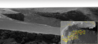
|
It's a lovely image in any case - Oppy's home for the past year.
Posted by: PhilCo126 Nov 2 2008, 03:23 PM
What are these parts visible in the recent Oppy panoramas:
I guess these are attachment point for the solar panels when these were folded? Official denomination?
Didnt find it here: http://hobbiton.thisside.net/rovermanual/
Nor on the NASA websites
so where else to turn
Posted by: djellison Nov 2 2008, 04:19 PM
Which bit of it? There's solar array mounting pyros on the left, solar cells alongt he middle, and the shoulder of the IDD on the right.
Posted by: PhilCo126 Nov 2 2008, 04:24 PM
Solar Array Pyro on the left , thanks Doug!
Posted by: djellison Nov 2 2008, 04:33 PM
Yeah - pyro-bolts that held the arrays together before deployment.
Posted by: PhilCo126 Nov 3 2008, 01:45 PM
So concluding this topic, we can say that Opportunity:
came out of Victoria Crater on Thursday 28th August 08 (sol 1634)
left Victoria Crater on Friday 17th October 08 (sol 1683)
Powered by Invision Power Board (http://www.invisionboard.com)
© Invision Power Services (http://www.invisionpower.com)