Printable Version of Topic
Click here to view this topic in its original format
Unmanned Spaceflight.com _ Opportunity _ Goodbye Victoria
Posted by: Tesheiner Oct 18 2008, 08:40 PM
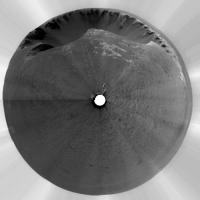
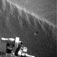
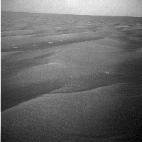
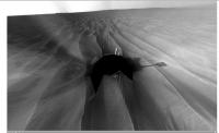
Have a look to this mosaic; it will probably be one of the lasts to include Victoria on sight.
|
|
Sol 1983 was driving day, about 47m SSW. And you know what? Like on many previous driving sols, "post-drive" images were taken (http://qt.exploratorium.edu/mars/opportunity/navcam/2008-10-18/) including a pancam mosaic called "drive_dir" and that one is NOT headed towards the next capes but to the SOUTH (-160º actually).
So, I would say that we are leaving Victoria for good!


Posted by: djellison Oct 18 2008, 08:48 PM
Steve's Pan Position C is not out of the question yet.
Posted by: Tesheiner Oct 18 2008, 09:03 PM
I would bet a dinner. 

This SSW figure is very VERY consistent with the heading of the "drive direction" pancam mosaic.
And one of the "exits" (referring to the terrain analysis maps) from Victoria's vicinity is about on that heading.
Posted by: Airbag Oct 18 2008, 09:18 PM
Either those are not the "ultimate" images or something happened, as the plan was for a much longer drive...maybe even a record length one. Well, time will tell!
Airbag
Posted by: Phil Stooke Oct 18 2008, 09:22 PM
Bye Bye Victoria - it was nice to see you but I've got to be going...
Phil
|
Posted by: Tesheiner Oct 18 2008, 09:25 PM
> Either those are not the "ultimate" images ...
They are.
Posted by: mhoward Oct 18 2008, 09:28 PM
http://mmb.unmannedspaceflight.com/MERBSol1683Navcam.mov
Posted by: Stu Oct 18 2008, 09:57 PM
http://cumbriansky.files.wordpress.com/2008/10/away3.jpg and - I think - appropriate quote to go with it...
Posted by: SFJCody Oct 18 2008, 10:04 PM
Nice. Alternatively you could have used the lyrics to the theme tune from that early 90s TV show about the mountie.

Posted by: ustrax Oct 18 2008, 11:03 PM
http://www.youtube.com/watch?v=HECJLH4onZk
[UMSFers:]
There's a sad sort of leaving Victoria, its capes and cliffs
And a soup dragon too
And down here on Earth an insignificant little cookie
Is popping out to say "cuckoo"
[UMSFers:]
Cuckoo, cuckoo
Regretfully they tell us Cuckoo, cuckoo
But firmly they compel us Cuckoo, cuckoo
To say goodbye . . .
[Doug:]
Cuckoo!
[UMSFers:]
. . . to you
[UMSFers:]
So long, farewell, auf Wiedersehen, good night
[Opportunity:]
I hate to go and leave this pretty sight
[UMSFers:]
So long, farewell, auf Wiedersehen, adieu
[Opportunity:]
Adieu, adieu, to beacon, Verde and Pigafetta too
[UMSFers:]
So long, farewell, au revoir, auf wiedersehen
[Opportunity:]
I'd like to stay and taste one more sulfate
[UMSFers:]
So long, farewell, auf Wiedersehen, goodbye
[Opportunity:]
I leave and heave a sigh and say goodbye -- Goodbye!
I'm glad to go, I cannot tell a lie
I've stucked, I've fled, I freely roll, I rove!
The road is long, Endeavour is at sight
[Children:]
So long, farewell, auf Wiedersehen, goodbye
Goodbye, goodbye, goodbye
[Oppy and UMSFers:]
Goodbye!
Posted by: Phil Stooke Oct 18 2008, 11:24 PM
"Nice. Alternatively you could have used the lyrics to the theme tune from that early 90s TV show about the mountie."
Yessss... "I'm an anaglyph and I'm all right,
I'm two-dimensional all day and 3D at night"
Phil
Posted by: dvandorn Oct 19 2008, 02:34 AM
So, Rui -- "The crater's alive with the sound of music"?
Or "How do you stop a rover like our Oppy?"
Or even "Carbonates, carbonates, our instruments cannot see them..."

-the other Doug
Posted by: nprev Oct 19 2008, 03:04 AM
...well done, esteemed Special Cookie Monster! Your creativity indeed is boundless...
Posted by: climber Oct 19 2008, 09:01 AM
I also bet a dinner that even once we'll arrive at Endeavour, most of us will try to find Victoria in the pancam shots


Posted by: Phil Stooke Oct 19 2008, 10:12 PM
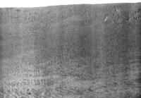
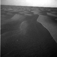
This is the pancam mosaic of drive direction images from the latest position. I have stretched it vertically to show near-horizon detail more clearly. Clearly visible at the middle is a smooth patch, with large drifts to its right (west in this south-looking view). I am having trouble matching individual features to HiRISE, but it looks like the smooth area must be the western one of the three 'exits'. That's my preferred exit anyway so I hope they use it!
Phil
|
Posted by: jamescanvin Oct 20 2008, 12:39 PM
Well spotted Phil.
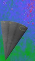
I've made a polar image of the 1683 drive direction images and overlaid it onto my latest driveability image (considerably higher resolution than anything I've posted on UMSF so far) showing how the images point straight at the prominent SSW 'ray' (South is at the top, pancams are rotated using tracking data, position is approximately Tesheiner's route map position)
In the second image I've pointed out a few features that I have (very tentatively) matched up.

|
|
James
Posted by: Ant103 Oct 20 2008, 03:45 PM
The goodbye to Victoria. In french, we say "adieu" but there is no word in english like this because we traduce good-bye as "au revoir". But we will never return back to Victoria.
Adieu Victoria 
http://www.db-prods.net/blog/wp-content/uploads/2008/10/sol1683-adieuvictoria.jpg
So, let write a new page of mars exploration history .
Posted by: elakdawalla Oct 20 2008, 03:59 PM
It's sad to say farewell to Victoria; but it's a happy day too. Opportunity's destination is has now been http://astrogeology.usgs.gov/HotTopics/index.php?/archives/345-Martian-Crater-Named-Endeavour.html Endeavour. Onward!
--Emily
Posted by: Juramike Oct 20 2008, 04:00 PM
http://www.youtube.com/watch?v=bMvqPffzDMQ&feature=related.....
(Couldn't resist!)
Posted by: Pavel Oct 20 2008, 05:38 PM
Ade, mein liebes Schätzelein 
Posted by: Stu Oct 20 2008, 10:04 PM
Okay, hands up... who wants to go back...?
http://img.photobucket.com/albums/v509/cumbriansky/Victory.jpg
Posted by: nprev Oct 20 2008, 10:46 PM
You bet...in a nice, flexible suit with a hard helmet, with a sturdy rock-pick and a digital hand-lens with a fat uplink! I'd take that thing apart layer by layer just to see what could be found (drooool....)
(Sorry; my passions overcome me! Nice work, Stu!)
Posted by: SFJCody Oct 21 2008, 07:07 AM
Is this a driving sol?
Posted by: Tesheiner Oct 21 2008, 07:56 AM
According to the imaging plan, yessss!!!
Posted by: jamescanvin Oct 21 2008, 05:42 PM
It's been a long time since I last worked with the tracking data - but if I've got this right, it looks like tosols drive was about 130m WSW (maybe a little more as the site ID was reset at the end) - that is directly away from Victoria.
Goodbye Victoria - Onwards!
James
Posted by: Tesheiner Oct 21 2008, 05:53 PM
Yup, at least 130m!
> maybe a little more as the site ID was reset at the end
Based in the time between the latest reading and the "0" of the new site I believe they are the same.
Posted by: Juramike Oct 21 2008, 05:56 PM
Ooooh! Anyone got an estimated position? I think we're on all five Terrain models now.
-Mike
Posted by: ustrax Oct 21 2008, 06:11 PM
Leaving the safety of the port for one more discovery saga...simply amazing!
Robert Frost: The Road Not Taken (1915)
Two roads diverged in a yellow wood,
And sorry I could not travel both
And be one traveler, long I stood
And looked down one as far as I could
To where it bent in the undergrowth.
Then took the other, as just as fair,
And having perhaps the better claim,
Because it was grassy and wanted wear;
Though as for that the passing there
Had worn them really about the same.
And both that morning equally lay
In leaves no step had trodden black.
Oh, I kept the first for another day!
Yet knowing how way leads on to way,
I doubted if I should ever come back.
I shall be telling this with a sigh
Somewhere ages and ages hence:
Two roads diverged in a wood, and I--
I took the one less traveled by,
And that has made all the difference.
EDITED: I think I see where we're headed...I think...to catch solid ground as soon as possible, and it looks likes there are at least two eroded rims that way...I like it!
Posted by: SFJCody Oct 21 2008, 08:47 PM
http://qt.exploratorium.edu/mars/opportunity/rear_hazcam/2008-10-21/1R277867690EFF9200P1311R0M1.JPG
Hmmm, moving south-west
Posted by: Shaka Oct 21 2008, 09:00 PM
Hmmm...why? 
Can anyone spot any likely objective along this track? Perhaps beyond Vicky's apron. Tesh?
Posted by: mhoward Oct 21 2008, 09:12 PM
http://mmb.unmannedspaceflight.com/MERBSol1686Drive.mov - QuickTime, 3.3 MB. This is (obviously) greatly time-compressed. It's based on the tracking data; I'm not really positive how completely accurate that makes it. The view direction is just south of west.
Posted by: djellison Oct 21 2008, 09:33 PM
Because, if you look at the route finding thread, the challenge of the next few months is to get thru the dune field that extends from about 1km to about 2km south of Endurance. If we can stay on 100m/sol terrain, it's a few months. If we get into dune-land, it's a year or more. So heading SE, to one of a couple of 'out' routes thru that dune field, is the fastest way to make good progress.
Doug
Posted by: Ant103 Oct 21 2008, 09:41 PM
First pics on Exploratorium of the beggining of the verrry long trek (Sol 1686 partial view, I think there are other images to complete this pan).
So, back to flat and sandy landscapes of Merdiani

|
Posted by: ustrax Oct 21 2008, 10:05 PM
Got a telegraphic mail from Steve from which I've extracted the following mantra...:
"We're outta here."
"We'll get there."
Posted by: Shaka Oct 21 2008, 10:51 PM
Doug
I assume you meant SW at this point. Meaning the drivers have opted for a route like Juramike's West Spur or South West Passage.
A run around west of the main dune field, accepting a longer route in exchange for longer daily progress. I guess the geologists have decided to forgo scientific targets inside the dune field, e.g. the exposed bedrock. Perhaps there is not such a big difference from what was studied in VC. O.K.

Posted by: djellison Oct 21 2008, 10:52 PM
Sorry - yeah - SW.
Posted by: Juramike Oct 21 2008, 10:53 PM
So, back to flat and sandy landscapes of Merdiani
Hit it!
 Blues_Brothers_hit_it.mp3 ( 22.45K )
: 944
Blues_Brothers_hit_it.mp3 ( 22.45K )
: 944
Posted by: Astro0 Oct 21 2008, 11:11 PM
Movie of the Sol 1686 drive...
Warp factor one Mr Sulu!
SS: "We're outta here!"
That's an understatement and a half.
Posted by: mhoward Oct 21 2008, 11:35 PM
Warp factor one Mr Sulu!
Yeah, data points are sparse at the beginning of the drive, so it does indeed look like it's flying. Plus I'm pretty sure the rovers never go that fast
SS: "Make it so..."
Posted by: BrianL Oct 22 2008, 02:38 AM
Well, assuming the rover drivers are still secretly using UMSF data for their route planning, SW would seem more likely, as Juramike indicated West Spur was bad, BAD! Does the current heading point toward any particular route entry point?
Posted by: Shaka Oct 22 2008, 03:51 AM
I've spent the last half hour in the lotus position, trying to channel Paolo's mind, but so far I can't get through. (next I'll try the aston martin position )
So I don't know the drivers' plan. JM said the West Spur route took the longest time, but it is actually safer, if your priority is to give the red zones a wide berth. I don't think anyone official has declared what sort of maximum distances Oppy might try to cover in one day's autonomous drive. Nor would I expect them to, lest they be held to it as an expectation. 200, 300, 400 meters? I do think that if they plan to 'stretch the envelope' , they will want as clear a ground as possible. With big enough daily jumps, the West Spur could turn out to be quite fast.
Posted by: Tesheiner Oct 22 2008, 08:51 AM
While we're on this "green" zone I would expect long drives on the 100m+ range and perhaps a really long one (> 150m) but only during the weekends.
BTW, we are not on restricted sols so today is yet another driving sol. Based on yesterday and today's imaging plan I expect they'll keep the current SW (actually WSW) heading.
Posted by: Gonzz Oct 22 2008, 10:03 AM
It sure is great to see the sandy sea once again, talk about 'deja vu'
Calm sea ahead, bigger waves await us, sooner or later, faster or slower, we'll get there (we hear'you comandante Squyres)
Posted by: climber Oct 22 2008, 10:39 AM
Next restricted sol would be on october 27th on sol 1692, so it'll be another week worth of possible each sol driving
Posted by: ilbasso Oct 22 2008, 04:58 PM
I like that! We can be there by Christmas at 300-400 meters per sol!
Posted by: SFJCody Oct 22 2008, 05:53 PM
I'm still confused by this direction. Hope we get some more info from the MER team soon.
Posted by: ustrax Oct 22 2008, 07:11 PM
SFJCody, so far http://www.unmannedspaceflight.com/index.php?s=&showtopic=4234&view=findpost&p=109289...
<I'm giggling>..."Too unreal?"...<I'm still giggling...>
Posted by: Stu Oct 22 2008, 07:50 PM
|
http://cumbriansky.wordpress.com/2008/10/22/farewell-victoria-endeavour-beckons
Posted by: mhoward Oct 22 2008, 08:02 PM
I love your work, Stu. But your sense of direction is terrible.
(Adding: It's the other way.)
Posted by: Stu Oct 22 2008, 08:43 PM
It's meant to be symbolic, not accurate 
Glad you like it tho.
Posted by: Shaka Oct 22 2008, 08:52 PM
The rest of us have driver's licenses, Stu has a poetic license.
So will it be the West Spur Route by Mike, or Rui's Route (west, then south)?
Only time will tell.
Posted by: Stu Oct 22 2008, 08:54 PM
You're right Shaka, and I just renewed my poetic license too. Cost a small fortune, and I had to have a new photo taken, but it's good through 2012 now, so it should see me through MSL's first few years of driving.
Posted by: climber Oct 22 2008, 09:17 PM
What country issue such a license?
Posted by: Stu Oct 22 2008, 09:22 PM
Narnia.
Posted by: nprev Oct 22 2008, 09:32 PM
Ah, he's too damn modest.
Stu has an unlimited poetic license from many countries, and the most important of these is the Country Of The Blind; he is their only light, and rightly treasured.
Posted by: jamescanvin Oct 22 2008, 11:04 PM
Another sol, another 127m WSW...
Posted by: BrianL Oct 22 2008, 11:12 PM
Sigh, just that much more distance to travel in the right direction.
Posted by: mhoward Oct 23 2008, 03:17 AM
It looks like it might have been longer, except the rover took a little detour (or zig-zag) in the middle of the drive. I'd love to know why, but for that we must wait...
At least it looks like she drove until late into the afternoon.
Posted by: mhoward Oct 23 2008, 03:42 AM
A little http://mmb.unmannedspaceflight.com/MERBSol1687Navcam.mov (1.5 MB)
Posted by: Tesheiner Oct 23 2008, 05:30 AM
You don't know why?!?
It's because she found http://www.unmannedspaceflight.com/index.php?s=&showtopic=5562&view=findpost&p=129247 in the middle of the plains.
Posted by: Astro0 Oct 23 2008, 06:02 AM
This takes me back...
The Return of the Little Dune Dents!
It's been so long...did they ever figure out what they were, I can't remember?!
|
Meanwhile, over at http://www.unmannedspaceflight.com/index.php?showtopic=5282&view=findpost&p=129287...!!!
Posted by: Ant103 Oct 23 2008, 06:59 AM
And the classic equirectangular pan
http://www.db-prods.net/blog/wp-content/uploads/2008/10/sol1687-pano.jpg
Posted by: Tesheiner Oct 23 2008, 08:40 AM
... and the classic http://www.unmannedspaceflight.com/index.php?s=&showtopic=681&view=findpost&p=129291 too.
Just checked the tracking info and today is NOT a driving sol, probably because yesterday pictures were downlinked too late for panning the next move.
Posted by: djellison Oct 23 2008, 09:12 AM
I see what they're doing ( I think ) - heading far enough west whilst on good ground so that we can run south toward some etched terrain, running between dunes on the way, instead of hitting any side on.
Doug
Posted by: Stu Oct 23 2008, 02:19 PM
3D view of part of the scene http://cumbriansky.wordpress.com/2008/10/23/oppy-plunges-into-the-dune-sea-of-meridiani, if anyone wants a look...
Posted by: Gonzz Oct 23 2008, 02:55 PM
There's something very poetic about the way these ripples stretch into the horizon.
They're showing the way to Endeavour
Magnificent desolation, once again
Posted by: Floyd Oct 23 2008, 03:44 PM
They decided that they were micro craters. This is the smallest yet.
Posted by: ustrax Oct 24 2008, 08:32 AM
I'm somehow pleased...comparing your http://www.unmannedspaceflight.com/index.php?s=&showtopic=681&view=findpost&p=129291 with my http://www.unmannedspaceflight.com/index.php?showtopic=4234&st=150&p=109289&#entry109289 looks like finally I was able to get one direction right along this mission...
(Sorry for the low definition of my map but I've deleted the original...)
|
See how I, through my fantastic precognitive powers, nailed the place where we would left Victoria?...
Posted by: BrianL Oct 24 2008, 12:17 PM
Well, I guess if you consider being a good 20 meters off "nailing it"...
Posted by: ustrax Oct 24 2008, 12:51 PM
What are 20 meters on a 12kms trek?...
Posted by: BrianL Oct 24 2008, 10:52 PM
Stu? Stu? Where did you go? I was going to remind you to check the dates.
Posted by: Stu Oct 24 2008, 11:05 PM
Posted in error, deleted in embarrassment
Posted by: nprev Oct 25 2008, 12:54 AM
Great quote as usual, Stu; you may have described my entire life quite concisely!
Posted by: Enceladus75 Oct 25 2008, 02:54 AM
Onwards to Endeavour! If Oppy is able to manage 100 metres a day, how fast could it realistically get to the edge of Endeavour? 1 year, 2 years or more?
Posted by: Juramike Oct 25 2008, 03:06 AM
Oppy's position based on Eduardo Tesheiner's Opportunity Route Map and the UMSF terrain models are posted http://www.unmannedspaceflight.com/index.php?s=&showtopic=5476&view=findpost&p=129421.
Looks almost like a straight line to the W Spur route entrance point.
(Maybe the Sol 1687 zig-zag was caused by Rui's super-secret mental powers acting on Oppy?)
-Mike
Posted by: Shaka Oct 25 2008, 05:30 AM
Yes, JM, the West Spur route is looking like a good bet at this point. The major difference in Rui's Route is that it ignores your red zone and runs straight down the middle of the etched terrain (exposed bedrock), midway between your West Spur and SW passages. Rui takes the geologists' preferences to heart and fearlessly confronts the big ripples. Beyond the red zone he continues in a more or less southerly route, whereas you loop back far to the east.
Which choice will Oppy make?
The tension is palpable.
Posted by: Tesheiner Oct 25 2008, 06:45 AM
Next move is planned for sol 1691 (Sunday) and the post-drive images are pointed due south.
Posted by: ustrax Oct 25 2008, 07:00 AM
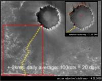
If it's another 100 and something meters drive that will put Oppy on one third of the timeline my inner glowing oracle pointed as the requested for it to accomplish the first leg of the journey, 20 days.
If my clearvoyant batteries don't run out, see you at Endeavour on February 8, 2010...
Posted by: climber Oct 25 2008, 09:05 AM
Why on my 56th birthday ?
Posted by: Juramike Oct 25 2008, 01:06 PM
Anyone else notice how Oppy looks like the planchette of a Ouija board out there?
(Channelling secret mental powers to the W..to the W....to the W...)
Posted by: Nirgal Oct 25 2008, 01:35 PM
I'm not a rover expert, but from the past experience with the Trek from Endurance to Victoria, I would say that a realistic estimate for Oppy's average "full speed progress" considering weekends, restricted sols etc. would be approximately 400 meters per week or about one and a half kilometers per month.
However, this "full speed" estimate does not include: 1. possible science stops and 2. unforseen incidents (stuck in dune, Odysee dropouts etc. )
So add another safety factor of two or so and we would have somwhere between 500 to 1000 meters per month on avareage which would result in an optimistic estimate of about 16 months for the whole Trek to Endevaour ...
Posted by: SFJCody Oct 27 2008, 10:35 PM
Looks like 1693 will be another driving sol.
Posted by: Ant103 Oct 28 2008, 09:55 AM
200 m ahead, back to the dunes on Sol 1691 :
http://www.db-prods.net/blog/wp-content/uploads/2008/10/sol1691-pano-backtothedunes.jpg
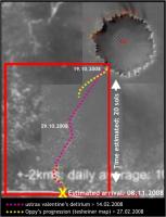
Posted by: ustrax Oct 28 2008, 11:53 AM
That will endanger my estimative...but good to see that, somehow, Oppy will cross "my" path 8 months after dreaming of it...
|
And from Ant103's image looks like the tide is rising...
Posted by: djellison Oct 28 2008, 01:55 PM
Don't go there. Don't start with a number and multiply it by numbers of days.
It
Never
Works
By that maths, Endurance to Victoria should have been <6 months. It was nearly two years. Just take it as it comes, step by step.
Doug
Posted by: Nirgal Oct 28 2008, 04:25 PM
Beautiful panorma, Ant !
this martian landscape never ceases to amaze me in its subtleness of change: how, for example the character of the dunes changes ever so slightly but distinctly only some hundreds of meters apart: for example, this "feathering" of the dune crests now looks even more pronounced and beatuiful than ever before ...
What an exciting adventure we have the privileg of taking part in !
Posted by: BrianL Oct 28 2008, 04:52 PM
Perhaps there is no basis for such fear, but those differences also worry me. They look like ripples we have driven safely before, but what if they turn at some point into soft, yielding ripples that can't be driven on anywhere, even in the troughs? I certainly feel more at ease when they are on one of the "highways". You know that safe, unyielding rock is near at hand,... er, wheel.
Posted by: Ant103 Oct 28 2008, 05:03 PM
Thanks Nirgal. It's a privilege, I agree. And I am constantly proud to work on pictures taken yestarday and sometimes today ON MARS! Great times we are living now .
The drive direction, taken on the same sol :
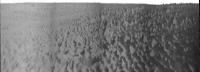
http://www.db-prods.net/blog/wp-content/uploads/2008/10/sol1691-pancampan-aseaofsand.jpg
Posted by: Tesheiner Oct 28 2008, 05:33 PM
> The drive direction, taken on the same sol
We should call it "sailing direction", perhaps.
Posted by: Ant103 Oct 28 2008, 05:40 PM
"sailing direction"
An excellent transition to my next picture, from the black & white pan. I've named it "A Sea Of Sand"
http://www.db-prods.net/blog/wp-content/uploads/2008/10/sol1691-pancampan-aseaofsand-colorized.jpg
Posted by: climber Oct 28 2008, 07:15 PM
Let's even call it the "Red Sea of Sand of Meridianii"
Posted by: Phil Stooke Oct 28 2008, 08:54 PM
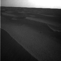
This is the horizon part of Ant103's panorama of the drive direction, with a bit of vertical stretching. A factor of ten. It shows that smooth patch off to the left - east - and the bigger drifts ahead and to the right. Looks like the outcrop area is slightly elevated. This doesn't really look ideal to me. I think the immediate drive might be in this direction, but I would expect a turn to the west in a while to head towards that smoother route.
Phil
|
Posted by: Tesheiner Oct 28 2008, 09:20 PM
Good work Ant & Phil!
> I think the immediate drive might be in this direction, but I would expect a turn to the west in a while to head towards that smoother route.
To the west or to the left - east?
I'm a bit puzzled by the current choice of route. There're smooth areas both to the west (W spur) and to the east (SW corridor) of the current position but everything, including today's planned post-drive images, indicates they are heading right to this big patch of bedrock due south.
Posted by: Phil Stooke Oct 28 2008, 09:44 PM
Either direction might work but I intended to say what I did say - right - or west, as I indicated on a map in the other thread.
Phil
Posted by: marsophile Oct 28 2008, 10:31 PM
> I think the immediate drive might be in this direction, but I would expect a turn to the west in a while to head towards that smoother route.
To the west or to the left - east?
I'm a bit puzzled by the current choice of route. There're smooth areas both to the west (W spur) and to the east (SW corridor) of the current position but everything, including today's planned post-drive images, indicates they are heading right to this big patch of bedrock due south.
http://planetary.org/blog/
Quote: "Opportunity was headed for an area where the north-south dunes of Meridiani Planum were spread thinly over exposed bedrock, a landscape that would provide Opportunity with a "highway" southward on its journey toward Endeavour crater."
Posted by: elakdawalla Oct 28 2008, 10:39 PM
Don't read more into my update than is there -- that's no more than a summary of what appears to be the consensus view on this forum! You guys are my best "source" for MER news, as you all follow it much more closely than I do. I think we all agree that the direction of Opportunity's drive is taking it toward more driveable terrain -- the debates here are about exactly which direction it's headed.
I'm sure there will be more informed detail forthcoming this weekend when Salley will post her usual update.
--Emily
Posted by: ustrax Oct 28 2008, 10:58 PM
Why should you be puzzled when, apparently, the rover is heading towards bedrock? doesn't that mean safer drives? At least that was what I had in mind when marking my path, aiming whenever possible to patches of solid ground and not smooth dunes...but hey...what do I know?...
Posted by: Phil Stooke Oct 28 2008, 11:14 PM
Unfortunately, in this area the bedrock outcrops have the largest drifts scattered across them. So they are not a 'highway' as they were near Erebus.
Phil
Posted by: belleraphon1 Oct 29 2008, 01:45 AM
Thinking the same thing, Phil... look like big dunes wandering the bedrock road ahead... we shall see .....
Looking at those sand sea vistas... I think of Arthur C. Clarke's "The Sands of Mars"... wouldn't we all love to be trotting along there in person... listening to the lonely whistle of wind....
Craig
Posted by: Juramike Oct 29 2008, 01:50 AM
I can't quite yet imagine what the wind would sound like...

Posted by: BrianL Oct 29 2008, 01:54 AM
Come on, Phil we're Canadians. That describes our highways perfectly.
Posted by: Pando Oct 29 2008, 01:55 AM
I think it's a great strategy having a sure footing of bedrock under the wheels and drive around the dunes. There is much less slippage and, with the availability of HiRISE maps, the route can be planned for longer distance ahead more accurately.
Posted by: Tesheiner Oct 29 2008, 05:47 AM
Understood. I got confused by your reference to the smooth terrain at the left on your Phil-o-vision.
That's my point too. However I hope we will see some clever usage of autonomous driving technics.
I'll use this same post to say that the drive planned for sol 1693 was executed and Opportunity moved another 110m due south. Expect bigger dunes right ahead.
Posted by: ustrax Oct 29 2008, 07:46 AM
Pando, my friend! Who would say we would be discussing this after all this years?...
Those are exactly my thoughts, even if we recall that near Jammerbugt we had some bedrock too, I believe that solid ground + HiRISE maps + new software are, in my humble special cookie opinion, the best option for Opportunity in the current scenario.
Tesheiner, I'm curious to see your updated map...
Posted by: peter59 Oct 29 2008, 07:54 AM
Posted by: Stu Oct 29 2008, 08:21 AM
Yep, they look pretty big... and just plain pretty, too...
http://cumbriansky.wordpress.com/2008/10/29/oppy-deep-into-the-sea-of-sand
Posted by: climber Oct 29 2008, 08:49 AM
If I get it correctly we're in restricted sols up to nov 11th or so. So we expect to drive each other day.
Anyway, it's so nice to get distance with 3 digits values
Posted by: Ant103 Oct 29 2008, 09:51 AM
Sol 1693 panoramas (navcam & pancam). I have the impression that this will be the traditionnal picturing set at the end of each drive
http://www.db-prods.net/blog/wp-content/uploads/2008/10/sol1693-pano.jpg
http://www.db-prods.net/blog/wp-content/uploads/2008/10/sol1693-pancam-pan.jpg
Posted by: Tesheiner Oct 29 2008, 09:56 AM
http://www.unmannedspaceflight.com/index.php?s=&showtopic=681&view=findpost&p=129650.
Posted by: ustrax Oct 29 2008, 10:47 AM
Obrigado!
I like too see paths converging...
I know I shouldn't but I'm starting to doubt my powers...
A good alternative, following the bedrock policy, would be (contrary to my idea of following for more +-7kms SE) to turn East near the location where I lay the border between Leg 01 and 02 in the image below:

|
EDITED: Tesheiner's map date has been corrected, thanks for the alert hal9000!
Posted by: ngunn Oct 29 2008, 11:06 AM
Surely not! To settle matters I propose a rigorous empirical test: at the end of leg 1 the rover will clone itself and follow both your guesses.
Posted by: PhilCo126 Oct 29 2008, 01:41 PM
Does Opportunity currently hold the top 3 longest single-sol drives?
Sol 410 = 220 meters (722 feet)
Sol1663 = 153 meters (500 feet)
in fact amazing compared to Sojourner which drove a total of 101 meters (333 feet = easier to remember) in 1997...
Posted by: climber Oct 29 2008, 02:19 PM
I bet for 222m on sol 2222, even easier Phil
Posted by: RobertEB Oct 29 2008, 03:12 PM
http://www.db-prods.net/blog/wp-content/uploads/2008/10/sol1693-pano.jpg
http://www.db-prods.net/blog/wp-content/uploads/2008/10/sol1693-pancam-pan.jpg
Two movie quotes come to mind;
"What a desolate place this is."
"Dune- Desert Planet- never one drop of rain on Arrakis"
I think the dunes of Mars are beautiful. When I look across that windswept landscape, I get a feeling that I have been there before. It feels like a place I have known, but there is something alien about it.
Posted by: djellison Oct 29 2008, 03:47 PM
Yes. I think they might be 410 ( 220m ), a couple of sols ago (about 200 ), and probably either another drive from a few days previous to that, or one of the drives shortly before 410.
Posted by: AndyG Oct 29 2008, 04:47 PM
I don't know that one. I thought, for a moment, it was from R.F.Scott - but I'm misremembering his "Great God! This is an awful place." Another quote - sadly apocryphal - was allegedly an advert for Shackleton's Nimrod expedition. Forgive the minor re-write!
"[Robots] wanted for hazardous journey. Low wages, bitter cold, long hours of complete darkness. Safe return doubtful. Honour and recognition in event of success."
Andy
Posted by: jmjawors Oct 29 2008, 05:14 PM
It's from Star Wars -- C3PO describing Tatooine. A very apt comparison! Especially if Oppy were to find moisture farms on her journey.
[/geek]
Posted by: Oersted Oct 29 2008, 11:37 PM
Another take on the Sea.... (from Ant103's pano):
http://dalsgaard.eu/2008-10.Mars-panorama-as-the-Sea/sol1691-pancampan-aseaofsand-Sea-and-ship.jpg
Click to enlarge.
- Cue Rod Stewart, "I am Sailing"....
Posted by: Pando Oct 30 2008, 03:51 AM
Sorry...

|
Posted by: BrianL Oct 30 2008, 04:30 AM
Ewww.... it's like the Gods were starting a Mars pysanka. 
Posted by: mhoward Oct 30 2008, 05:25 AM
Some images from back on Sol 1686 came down, and it's a http://mmb.unmannedspaceflight.com/MERBSol1686Navcam.mov (QuickTime, 3MB) - very appropriate for the "Goodbye Victoria" thread, since Victoria is just an elevated horizon to the northeast. Some light-colored exposed rock is visible in the distance to the southwest - that's about where Opportunity is today, on Sol 1694, or actually just past midnight on 1695.
Posted by: SFJCody Oct 30 2008, 06:46 PM
On sol sixteen hundred and ninety five
M-E-R-B went for a drive
Posted by: Oersted Oct 30 2008, 11:49 PM
Posted by: Shaka Oct 31 2008, 02:43 AM
O.K., compadres, it looks like Rui's Route and Paolo's agree at this point!
The genes of Magellan triumph once more!
http://qt.exploratorium.edu/mars/opportunity/rear_hazcam/2008-10-30/1R278661306EFF93AVP1311L0M1.JPG
Posted by: mhoward Oct 31 2008, 02:50 AM
Wow.
I did a quick Pancam anaglyph mosaic. It's not very good but it's all I have time for.
http://www.flickr.com/photos/marscat/2988416842/sizes/o/
Posted by: mhoward Oct 31 2008, 03:02 AM
Okay, and a quick http://mmb.unmannedspaceflight.com/MERBSol1695Navcam.mov, looking south.
These drifts don't look so tough. Except maybe that one to the left. Looking forward to seeing our position on the map...
Posted by: Phil Stooke Oct 31 2008, 03:33 AM
It's about here.
Phil

|
Posted by: Marz Oct 31 2008, 03:33 AM
These drifts don't look so tough. Except maybe that one to the left. Looking forward to seeing our position on the map...
w00t! back on the Blueberry Highway!
Posted by: Astro0 Oct 31 2008, 03:48 AM
Hmm. A new drunken sailor technique or something else interesting. Unusual half frame look at the rear wheels.
Animation:

|
BTW - Is it time to start a new thread for this journey? Victoria is now 'far' behind. 'The Road to Endeavour: Leg One' perhaps. Tesh, Rui?
Posted by: mhoward Oct 31 2008, 03:51 AM
I clearly don't understand how the driving on these drifts works. We drove right over some that I would have avoided. I hope the rest of the journey goes like this.
Posted by: mhoward Oct 31 2008, 03:53 AM
Making a mark for optical navigation?
Posted by: CosmicRocker Oct 31 2008, 05:59 AM
I'd like to see the marks in a navcam image. It appeared more like a dance to me than a drunken stumble, but I can't quite name the dance step.
Posted by: Pando Oct 31 2008, 06:08 AM
It's the Yo-Ho Yo-Ho dance (http://www.unmannedspaceflight.com/index.php?act=findpost&pid=129734)...

Posted by: CosmicRocker Oct 31 2008, 07:23 AM
Hehe. Do you mean like this?
We pillage and plunder, we rifle and loot.
Drink up me 'earties, yo ho.
We kidnap and ravage and don't give a hoot.
Drink up me 'earties, yo ho."
We must be careful about the waves and the pirates on this voyage.
Posted by: ustrax Oct 31 2008, 07:59 AM
Look Ma! No algorythms!

|
Posted by: Stu Oct 31 2008, 08:02 AM
http://cumbriansky.wordpress.com/2008/10/31/oppy-on-the-rocks... ain't no big surprise...
Posted by: Juramike Oct 31 2008, 10:24 AM
I wonder if they chose this route to try out some of the new automatic driving software on more challenging terrain?
Or if they have some science targets in mind?
Either way, this will provide a great opportunity (!) to try and correlate with predicted models as they drive over increasingly difficult terrain. (Are the drivers using this to test out their terrain models?)
-Mike
Posted by: Geert Oct 31 2008, 10:48 AM
Sounds unlikely to me, the software can be easily tested on earth using simulations or backup hardware, no use to do the testing on Mars. Also, which ever route they select, there will always be challenging terrain ahead so not much use to run as fast as possible towards the highest dunes.
Sounds more likely to me, bedrock is a lot more interesting then sand and there might be other reasons. Looking at the HiRISE images I don't believe so much in the 'highway' story, there are some open stretches with bedrock but further on the 'wavelength' of the dunes gets less and there are a lot of cross-dunes, to me this doesn't look like terrain where you can make a lot of speed. But probably the real drivers have more information and certainly far more experience.
What worries me is the risk of loosing a wheel, this isn't the sort of terrain to drive through with only 5 wheels I should think... Why steer yourself into this maze if there is nice flat ground close by? But there is more on heaven and earth then thou hast dreamed of..
Or ours?
Posted by: Ant103 Oct 31 2008, 04:26 PM
Sol 1695 navcam and pancam set
http://www.db-prods.net/blog/wp-content/uploads/2008/10/sol1696-pano.jpg
http://www.db-prods.net/blog/wp-content/uploads/2008/10/sol1695-pancam.jpg
Posted by: Nirgal Oct 31 2008, 07:09 PM
Sounds more likely to me, bedrock is a lot more interesting
I hope not too soon
We studied this kind of bedrock literally a thousand times by now (like the long stop at Olympia etc.)
If I understood the new rover strategy correctly, then now is the time to reverse the priorities from rock studies to driving for a while ...
and spare the science for the important cases when/if we find something *really* new ...
Posted by: PhilCo126 Oct 31 2008, 07:13 PM
Don't mention "science targets" we're on the road again...
Posted by: marswiggle Oct 31 2008, 07:48 PM
An anaglyph of Oppy's current locations from HiRise imagery, looking to the south, shown at a slightly oblique angle. The resolution is full transversely (at the bottom) and ~65 % longitudinally. Note that the 'real' depth in the anaglyph is relative to the (image) surface, so there's no visual depth in the seemingly oblique perspective which is just a simple visualization tehcnique.
The beginning of the drift-free highway about 400 m south from Oppy is just visible near the upper right corner.
|
Posted by: Tesheiner Oct 31 2008, 09:57 PM
Some tidbits from the http://www.planetary.org/news/2008/1031_Mars_Exploration_Rovers_Update_Spirit.html:
(thanks Bobby for the heads up)
Last weekend, we did a 216-meter drive that fell short of our all-time record by just 4 meters," offered Squyres.
Both Spirit and Opportunity are downlinking data every day to free up flash memory space in preparation for solar conjunction ... The solar conjunction begins at the end of November, so the team has charged the rovers with getting all recent images and science observations home so there will be plenty of room to store the data collected during the solar conjunction.
The plan is to head southwest to intersect some terrain that has a fair amount of pavement-like outcrop on it, Squyres said. Expounded Matijevic: "This area [which has not yet been named] is about a kilometer or kilometer and a half south of Victoria and we're moving pretty well along the rim of the crater down towards that outcrop." From that point, said Squyres, "we'll just follow the yellow brick road to the south."
... "We've been keeping our eyes open and every day we look around for a cobble to look at," Squyres said. The team would like to find one on which the rover can place its instrument deployment device (IDD) during solar conjunction, he noted.
We've had to go a little bit out of our way with Opportunity, but we have generally been traversing fairly well," said Matijevic. Even so, he added, "the path we sort of picked to the new crater goes around some of these obstacles, the purgatoids, and probably means we'll be driving more like a total of 18 kilometers to get to the edge of Endeavour."
Edited: During the final sols of September, Opportunity crossed the 12-kilometer (7.5-mile) milestone ...
... and already crossed the 13km milestone too (sol 1695, if I'm not wrong).
Posted by: DFinfrock Oct 31 2008, 10:17 PM
[ "we'll be driving more like a total of 18 kilometers to get to the edge of Endeavour."]
That sounds like a long way. But Oppy did 216 meters in one day. A 180 meter drive in a single day puts us 1% of the way there. We only need 100 of those 180 meter drives to get there!
Posted by: climber Oct 31 2008, 11:08 PM
A little reminder : she was garenty for 600m during her whole life
Posted by: djellison Oct 31 2008, 11:34 PM
Has done 13k, asking for another 18k, so a total ask of 31km
Posted by: Geert Nov 1 2008, 03:14 AM
Which would mean she is getting closer to the all-time record set by the Soviet Lunokhod 2, which travelled 37 km (on the moon). Never thought that the MER's would get anywhere near that distance, there is a big difference in how both machines were run (reflecting the difference in distance earth-moon and earth-mars) and the Lunokhods were moving a lot faster.
Posted by: mhoward Nov 1 2008, 03:36 AM
Some older images came down. Here's my attempt at the http://mmb.unmannedspaceflight.com/MERB1691_1692Navcam.mov QuickTime VR (2.3 MB). I've adjusted this one so you can zoom way out; pan all the way down for a pseudo-polar. And it starts out looking south.
Posted by: Tman Nov 1 2008, 10:14 AM
Wow, that's nearly perfect. Thanks Michael!
|
Posted by: RoverDriver Nov 5 2008, 11:15 PM
Animation:
|
|
BTW - Is it time to start a new thread for this journey? Victoria is now 'far' behind. 'The Road to Endeavour: Leg One' perhaps. Tesh, Rui?
Tap, tap. Is this thing on? Well, it seems that for the time being I can post, with some restrictions, to UMSF!
--
These subframe RHAZ were taken to monitor the path taken during the autonav portion of the drive. Autonav is pretty CPU intensive and it depends on how wide is the area analyzed in front of the rover. If we use only a single NAVCAM frame we can only drive straight ahead. In this configuration autonav will only stop the rover in case the road straight ahead is blocked.
As you are aware, the stuck RF wheel makes our "straight ahead" driving drift to the left. So from time to time the rover needs to correct the heading but in order to do so we need to use ore than one NAVCAM frame, which makes it a much slower driving. We are experimenting with some techniques to reduce the wider field of view autonav to a minimum and therefore make as much progress as possible given the alloted time for driving.
Paolo
Posted by: TheChemist Nov 5 2008, 11:26 PM
So nice to have you back !
Posted by: Shaka Nov 5 2008, 11:32 PM
Ciao, Paolo! Come vai?
Very glad to hear from you again!
Every time Oppy makes a turn, we're thinking, What is Paolo up to now?
I am so very pleased to know that sometimes we will be finding out in the future.
You cannot imagine how much that magnifies our enjoyment of the MER adventure.
Posted by: fredk Nov 5 2008, 11:39 PM
We hear you loud and clear, Paolo! I echo the last comments completely. It is so good to learn something of what's behind the images we see, instead of just guessing like we often do here!
Are you able to enlighten us at all on what's behind the current choice of route? Science/cobbles, easier autonav, easier driving,...?
Posted by: RoverDriver Nov 6 2008, 12:07 AM
Are you able to enlighten us at all on what's behind the current choice of route? Science/cobbles, easier autonav, easier driving,...?
The route we are following should minimize encounter with Purgatoids. It will be considerably longer than a direct route but should be safer and maximize science return.
As for what I have been doing recently: for the past few weeks I have been busy on the other side of the planet trying to push a rover up a slope.
Paolo
Posted by: mhoward Nov 6 2008, 04:07 AM
Nice to see you back, Paolo. We'll take what bits of information we can get and not ask too much. So many questions come up along the way.
Posted by: MahFL Nov 6 2008, 10:50 AM
They don't build rovers so the wheels drop off after 601 m.......
Posted by: Nirgal Nov 6 2008, 03:37 PM
This is great to have you back on the forum, Rover Driver !
Posted by: fredk Nov 6 2008, 07:12 PM
As we say farewell to Victoria, here are a couple of long baseline stereo views of its cliffs, first from sols 1668/70 and second from sols 1682/83 showing Cape Victory:

|
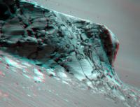
|
It will be a long time before we have views this spectacular from Oppy again...
Posted by: CryptoEngineer Nov 6 2008, 07:22 PM
Seconded! (or is it thirded!).
I've been following UMSF since soon after the landings, but rarely
post. One thing I've been wondering about:
What sensors are available for autonav? I ask because a lot of the
time in the march to and from Victoria, it looked to me like a
'follow the trough' algorithm would have been useful. Oppy
seems to spend a lot more time trying to go between ridges
rather than cross them.
I'm under the strong impression (if I'm wrong, just stop reading)
that the MERs have tiltmeters. An algorithm which said, in effect,
'As long as wheel slip is low, steer gently towards whichever front
wheel is downhill' would allow Oppy to track along a trough.
just another back seat driver.....
ce
Posted by: PhilCo126 Nov 7 2008, 10:04 AM
Just explaining an odd term for non-native English speakers: Purgatoids = larger ripples (dangerous dunes in fact)
Posted by: mhoward Nov 7 2008, 02:11 PM
For any newbies, we should add that it's not just an 'English-ism', but rather a Mars Exploration Rover-specific term. Purgatoids are drifts that look like 'Purgatory', where Opportunity famously got stuck for a long time.
Posted by: Fran Ontanaya Nov 7 2008, 06:56 PM
Purgatoids from Mars -- I would buy that if it was a pulp sci-fi book.
Posted by: avkillick Nov 7 2008, 07:20 PM
Purgatoids - an irritation that can be diminished with some 'Preparation P'
Posted by: RoverDriver Nov 7 2008, 08:24 PM
I've been following UMSF since soon after the landings, but rarely
post. One thing I've been wondering about:
What sensors are available for autonav? I ask because a lot of the
time in the march to and from Victoria, it looked to me like a
'follow the trough' algorithm would have been useful. Oppy
seems to spend a lot more time trying to go between ridges
rather than cross them.
I'm under the strong impression (if I'm wrong, just stop reading)
that the MERs have tiltmeters. An algorithm which said, in effect,
'As long as wheel slip is low, steer gently towards whichever front
wheel is downhill' would allow Oppy to track along a trough.
just another back seat driver.....
ce
This is an excellent question. When we talk about an "autonav" drive we intend a drive where cameras are used to observe the terrain around the vehicle and determine if there is a safe path or if the path specified is safe. This drive modality is pretty expensive (slower driving). You also mention "low slip". In order to measure slip, we need to use the cameras to measure the actual rover motion compared to the commanded motion (visual odometry). This is another CPU intensive task and it is used only when needed, either when we are on slopes or periodically on long drives (to verify we are still moving and not embedded in a ripple for example).
The rovers also have accelerometers and gyros (what you called "tiltmeters") assembled in an IMU (inertial measurement unit) that allows to accurately measure roll, pitch and yaw (RPY) of the rover. If you are interested you can google around and you will find which make/model and its specs. This sensor is turned on every time we drive and constantly provides the rover with the RPY, the rover "attitude". This information is important not only for driving but for communication (where to point the antenna) and cameras and MTES on the PMA.
While traversing the big ripples from Purgatory down to Victoria Anulus we used the IMU to specify safe limits on RPY but never used roll and/or pitch measurements to dynamically alter the rover's path. We have begun using RPY measurements to dynamically adapt the rover's path on both rovers only recently.
We also have sensors that report the configuration of the suspension system (rockers/bogies) and recently we used these measurements as well to dynamically modify the path or behaviour of the rover.
While it is relatively easy to come up with a strategy to drive between ripple crests, it is very difficult to ensure the vehicle will recognize an unsafe condition and stop. These new "smart" sequences quickly become very complex and difficult to prove safe in all conditions.
Paolo
Posted by: imipak Nov 7 2008, 11:36 PM
"We will not see the like of those days again."
I learned a new word from the kids at work this week - "facepalm" - I'm still not absolutely certain what it means, but I can picture many geologically aware readers doing one in a moment's time, so apologies if this is a silly question. There seem to be quite a few protuding nodule-like features on Cape Victory evident in fredk's analglyph, including one right in the middle that looks almost like a freeze-frame of a cannon-ball smacking into a castle wall a few hundred years ago. Why might the slightly harder rock which erodes out in this way take a shape that crosses many vertical layers? And why might it be different from Duck Bay? Is there a terrestrial analogue?
Posted by: CosmicRocker Nov 8 2008, 06:52 AM
No facepalm activity here. I was intrigued.
I'm not sure that I know the answer to your question, imipak, but I am going to hazard a guess at my peril. I think I see the features you are describing, and I believe they could be the result of wind erosion, temperature variations, and the three dimensional geometry of the fractures in the rock. I think it is safe to bet that the fractures in the rock were created by the impact that created Victoria Crater. If you look at the fractures on the face of Cape Victory (and in other capes and bays), you will notice that the bedrock has been broken into a lot of triangular and rhomboidal blocks.
At least, that's how it appears on the approximately flat faces of the capes. But, the fractured blocks are three dimensional, so many of them quite likely have pointed, pyramidal ends.
Erosion typically follows planes of weakness, when they exist in bedrock. In this case, it appears that some of the erosion is following the fractures. Fractures can also direct mineral-rich ground waters which can cause some parts of the rock to become harder or softer. Finally, since the fractures physically break the rock into separate blocks, freeze/thaw and/or diurnal, thermal expansion/contraction cycles can cause blocks of rock to move with respect to one another. I think your cannonballs might be the pointy, pyramidal ends of fractured bedrock blocks.
Sorry about the long and arcane explanation, but you did ask for it.
Posted by: Phil Stooke Nov 11 2008, 02:06 AM
http://qt.exploratorium.edu/mars/opportunity/pancam/2008-11-10/1P277496483EFF91G3P2580L6M2.JPG
Are those Opportunity's tracks near Nevada in the top right corner of this image?
Phil
Posted by: CosmicRocker Nov 11 2008, 06:19 AM
Good eye, Phil. I think those must be Opportunity's tracks. The alignment of the view across Cape Victory seems about right, and the shape of those markings nicely matches Eduardo's map of Opportunity's attempts to approach the cliff face.
Posted by: climber Nov 11 2008, 05:25 PM
Isn't it ol' Vicky :

|
Posted by: fredk Nov 11 2008, 07:02 PM
That's not 'ol Victoria. That's a smaller crater off to the northwest, if I'm correct.
It's hard to make out Victoria from a distance, since it doesn't have any real raised rim. Here's an example of the view from sol 1686:
http://marsrovers.jpl.nasa.gov/gallery/all/1/n/1686/1N277868308EFF9200P1635R0M2.JPG
Posted by: mhoward Nov 11 2008, 08:06 PM
You're correct - it's not Victoria. Whatever it is, it was to the northwest on sol 1687. This particular image was taken on sol 1689.
Posted by: fredk Nov 11 2008, 08:31 PM
This must be it (white arrow). I haven't seen a name for it.

|
Posted by: mhoward Nov 11 2008, 08:35 PM
Yep - that's got to be it.
Posted by: Shaka Dec 7 2008, 08:41 PM
Without wishing to disturb the blissful silence of our acute "conjunctionitis", now that Victoria Crater is virtually out of sight, yet before it passes too totally out of mind, we might profit from a thoughtful look at the recent paper in JGR-Planets which summarizes the state of mind of our esteemed PIs (some of them) concerning the processes which produced Vicky in the first place, to whit:
Degradation of Victoria crater, Mars
John A. Grant, Sharon A. Wilson, Barbara A. Cohen, Matthew P. Golombek,
Paul E. Geissler, Robert J. Sullivan, Randolph L. Kirk, and Timothy J. Parker
JOURNAL OF GEOPHYSICAL RESEARCH, VOL. 113, E11010, doi:10.1029/2008JE003155, 2
Ideally we would all have access to the complete paper before discussing its findings, but harsh reality prevents that for many of our members, so it occurred to me to liberally quote from the paper, limited mainly to substantive observations and conclusions. Those wishing details as to the methods of observations, raw data and figures, and discussion of alternate interpretations will need to visit a library, or at least request them here.
To begin, the basic descriptions:
Victoria is a relatively simple, bowl-shaped structure that presents considerable evidence for significant degradation: it displays a low, serrated, raised rim characterized by alternating alcoves and promontories, hereafter referred to as bays and capes, respectively;
The vast majority of the crater floor is covered by smooth, unconsolidated fines that transition into dunes toward the crater center. Individual dunes are up to 5 m high, and orientation of the dominant crests is inferred to be approximately orthogonal to the present prevailing wind direction.
Comparison between observed morphology and that expected for pristine craters 500750 m across indicates that the original, pristine crater was close to 600 m in diameter. Hence, the crater has been erosionally widened by 150 m and infilled by 50 m of sediments.
The authors base their inference of the original dimensions of VC from the well-established model for fresh craters following the normal processes of collapse from the transient form. The original diameter is varied to fit that needed to produce, after erosion, the present crater in terms of rim height and width, thickness of ejecta remaining etc.
Eolian processes are responsible for most crater modification, but lesser mass wasting or gully activity contributions cannot be ruled out.
The flat annulus of VC, together with its serrated edge are, IMNSHO, its most distinctive features, not seen in thousands of other craters in other areas of Mars, on other bodies of the solar system, and through a wide range of degradational states.
The annulus formed when 1 m deflation of the ejecta created a lag of more resistant hematite spherules that trapped <1020 cm of darker, regional basaltic sands.
Bays extend an average of 50 m into the rim and plains surrounding the crater, ranging between 25 and 95 m, and partly accommodate the 150 m widening... The two deepest bays, dubbed Duck Bay and Bottomless Bay, extend 95 and 74 m into the rim, respectively. Bay surfaces slope into the crater at an average of 19 degrees (range from 14 to 26), well below the angle of repose.
Bay surface roughness is generally low over distances of 110 m with rock surfaces appearing planed off to form ventifacts eroded by sediments blowing into and out of the crater.
Capes expose a sequence of in situ rocks overlain by the ejecta deposit... Interestingly, there appears to be relatively little difference in the erodibility of the ejecta overlying the capes and the capes themselves.
...Most capes are not flanked by significant talus, and their bases often remain exposed and are notched and windscoured...Some talus blocks show an obvious narrowing near their bases, suggesting erosion by saltating sand, whereas others are partially buried by drift materials.
Erosion is fastest where windblown sediment scours exposed and relatively weak bedrock and ejecta...
The fact that the ejecta layer appears to have a similar resistance to erosion as the bedrock implies that there is little to no impact melt binding the ejecta deposit...
Evolution of the bays was likely enhanced by wind erosion that exploited structural weaknesses in the wall, such as tear faults, that can originate when adjacent rim segments experience differential uplift during crater formation...
The facts that impact melt is (apparently) absent, and that radially-oriented "tear faults" could have initiated the development of bays, offer the kind of specializations needed to explain the rarity of Victoria-type craters. Such characters may be a result of the 'weak' nature of Meridiani bedrock compared to other bedrock in the solar system.
Alternative scenarios are not supported. Some might ask, though, whether such features fully account for the rarity of the "cape-and-bay" rim form?
...we conclude that there is no evidence at Victoria crater suggesting that it was completely filled and subsequently exhumed as suggested by Edgett [2005], and there is not any evidence for degradation by water-related processes.
Finally, the authors suggest a character of VC which could explain the rarity of its occurrence, namely that it represents a 'snapshot' view of a (relatively brief ?) intermediate stage within a degradational sequence for Victoria-sized craters in the Meridiani area.
Other stages in the sequence may be represented by other craters studied by Oppy, such as Endurance (an earlier stage) and Erebus (later stage).
The successive processes in this evolution can be summarized as follows:
Some of the dark-toned basaltic sand is trapped within the crater and causes net infilling over time.
Stripping of sediments from the rim and ejecta creates a lag of more resistant hematite spherules that traps some of the regional basaltic sands, slows additional erosion, and leads to evolution of a surrounding annulus...
Continued backwasting of the walls, predominantly by eolian processes, exploits structural weaknesses (e.g. tear faults) that lead to locally faster backwasting and evolution of the alcoves or bays...
As additional sediments are carried into the crater from the surrounding plains, some are swept into dunes, and net infilling begins to outpace backwasting of the walls. Eventually, bays become rounded and smoothed by sediments blowing into and out of the crater...
...ongoing infilling by sediments delivered from outside of the crater becomes relatively more important in modification and leads to slow infilling of the remaining relief.
In their most degraded forms, craters are filled to the level of the surrounding plains, and the surrounding annulus is slowly eroded and fades. At this advanced degradation state, craters are marked only by outcrops indicating what remains of their rims...
In concluding, note that the authors do not suggest the presence of frozen volatiles (i.e. water) in the Meridiani crust as an essential feature in explaining Victoria Crater evolution. This ingredient appears to be important in the formation of other Martian crater types at higher latitudes (e.g. pedestal craters), and it had figured large in a speculative scenario I concocted an age or two ago to explain Vicky, before we actually reached her. (Ignorance was certainly bliss!) I still think, however, that there are more questions remaining, hidden beneath her generous skirts, regarding her 'special' status among impact craters. I would, at the least, like to see a more thorough census of the rim forms of small craters on the Plain of Meridiani and other similar Martian substrata (e.g. hematite-rich zones). I can't be comfortable with only one or two examples of Victoriana.
YMMV
So who wants to instigate a discussion/argument/battle?
Conjunction still has days to go.
Posted by: Phil Stooke Dec 7 2008, 10:36 PM
My impression from browsing MOC and HiRISE images of Meridiani was that these serrated crater walls are common in this area. In fact even Endurance can be seen as a small example, with just a couple of capes. I don't recall seeing them in other areas though, so thry may require the kinds of rock found here. I think the cemented sands just disintegrate over time, resulting in a lack of ejecta blocks on the rim, a limited population of large talus blocks below the capes, and probably causing undermining of the walls over time which hastens the formation of each bay.
Phil
Posted by: Shaka Dec 8 2008, 12:18 AM
I'd certainly like to see those other craters, Phil. Unfortunately, I can't work with the monster HiRISE files, and need someone to pare them down. I do remember from a couple of years ago a clear example of a serrated crater, indeed, a quite bizarre 'double-decker' with TWO concentric serrated rims.
But I'd be far happier with this hypothesis, if I could see a few more in the serrated degradation stage.
Posted by: dvandorn Dec 8 2008, 05:11 AM
I will point out that Endurance is characterized by incipient "bay" formation that looks for all the world as if the crater wall had been undercut by erosion (likely aeolian) and the upper surface had collapsed in a sheet into the now-enlarged crater. This fits is rather well with the description of Victoria's bay formation.
-the other Doug
Posted by: Astro0 Dec 8 2008, 06:07 AM
Shake: "example of a serrated crater, indeed, a quite bizarre 'double-decker' with TWO concentric serrated rims"
This one or something like it? A few examples across Meridiani Planum. Bizarre indeed!
http://hirise.lpl.arizona.edu/PSP_001348_1770
Astro0
Posted by: Oersted Dec 8 2008, 01:38 PM
Consecutive hits from a Shoemaker-Levy-like string of bodies?
Posted by: Juramike Dec 8 2008, 01:46 PM
How about a normal crater that blasted through two layers of rock with differing resistance to erosion?
The upper layer (with the bright white rim) is softer and got easily eroded and blew away while being expanded. The lower portion was more erosion resistant and maintained its shape over time. The inner "crater" is the lower portion of the original crater that was less eroded (thus less enlarged). The inner shelf is the contact between the two layers.
-Mike
Posted by: Phil Stooke Dec 8 2008, 04:40 PM
Shaka - check these out: (they lead to JPGs, resolution reduced but still OK)
Here's a giant example:
http://hirise-pds.lpl.arizona.edu/PDS/EXTRAS/RDR/PSP/ORB_009000_009099/PSP_009075_1800/PSP_009075_1800_RED.abrowse.jpg
Here is a degraded example (top right):
http://hirise-pds.lpl.arizona.edu/PDS/EXTRAS/RDR/PSP/ORB_003500_003599/PSP_003511_1780/PSP_003511_1780_RED.abrowse.jpg
One big example and some smaller ones:
http://global-data.mars.asu.edu/moc/images/large/S0701971
Many craters, some with a few capes and bays:
http://global-data.mars.asu.edu/moc/images/large/E0500154
Similar one:
http://global-data.mars.asu.edu/moc/images/large/E0201844
Another big example:
http://hirise-pds.lpl.arizona.edu/PDS/EXTRAS/RDR/PSP/ORB_003500_003599/PSP_003590_1775/PSP_003590_1775_RED.abrowse.jpg
Phil
Posted by: Shaka Dec 8 2008, 10:13 PM
Good Lord, Phil, I never saw so many ugly, irregular craters in all my life! 
If my experience with crater photos had begun with these, I would be struggling to explain the neatly circular craters elsewhere as the bizarre anomalies.
Compared to these, Victoria is a model of regularity; its 'teeth' are far more uniform around the whole circumference than just about ANY in your photos!
And I thought I understood impact cratering!
I have a headache. I think I'll go lie down.
Posted by: CosmicRocker Dec 9 2008, 07:39 AM
Those appear to me to be more recent impacts into older sediments.
Posted by: Doc Dec 9 2008, 08:21 AM
The impacts are likely in old sediments. But how do you know if the impact craters are recent?
Posted by: Shaka Dec 9 2008, 10:49 PM
Well...ahem...Conventional wisdom would say that the youngest craters had the simplest, circular, well upraised rim, and a crater depth to diameter ratio close to 0.2 (for small, simple primary craters). That would imply that just about none of the craters in Phil's photos are very young.
What does that tell us about "conventional wisdom"? That's why I have a headache.
Posted by: Stu Dec 18 2008, 09:45 PM
Just a dark line on the horizon now...
http://roadtoendeavour.wordpress.com/2008/12/18/farewell-victoria
(well spotted, hort! )
Posted by: jamescanvin Dec 19 2008, 08:22 AM
Yes I spotted it yesterday while stitching parts of the Santorini pan - it came as a nice surprise.
Posted by: algorimancer May 22 2009, 05:28 PM
There is a very readable paper in the current issue (22 May 2009) of the journal Science summarizing the results of the exploration of Victoria, "Exploration of Victoria Crater by the Mars Rover Opportunity", by Squyres et al. No dramatic surprises, but a nice summary.
Posted by: alan May 22 2009, 07:46 PM
NASA Rover Sees Variable Environmental History at Martian Crater
Other rocks on the rim of the crater apparently were excavated from deep within it when the object hit. These rocks bear a type of iron-rich small spheres, or spherules, that the rover team nicknamed "blueberries" when Opportunity first saw them in 2004. The spherules formed from interaction with water penetrating the rocks. The spherules in rocks deeper in the crater are larger than those in overlying layers, suggesting the action of groundwater was more intense at greater depth.
Inside Duck Bay, the rover found that, in some ways, the lower layers differ from overlying ones. The lower layers showed less sulfur and iron, more aluminum and silicon. This composition matches patterns Opportunity found earlier at the smaller Endurance Crater, about 6 kilometers (4 miles) away from Victoria, indicating the processes that varied the environmental conditions recorded in the rocks were regional, not just local.
http://www.jpl.nasa.gov/news/news.cfm?release=2009-088
Posted by: stewjack May 23 2009, 12:55 AM
The National Public Radio show and podcast Science Friday has a podcast featuring Steve Squyres that mention the paper.
http://www.sciencefriday.com/program/archives/200905224 (broadcast Friday, May 22nd, 2009)
Researchers published new findings based on data collected by rover Opportunity during its exploration of Victoria Crater in the journal Science this week. The rock and sediment features in the crater, scientists say, indicate that liquid water played an important role in shaping a sizable area of the planet long ago. Victoria crater showed water-driven features similar to those found at other crater sites several miles away.
Direct Download of Podcast mp3 ( 8.3 MB )
http://podcastdownload.npr.org/anon.npr-podcasts/podcast/510221/104479138/npr_104479138.mp3
Jack
Posted by: Oersted May 23 2009, 10:33 AM
Great listening, thx stewjack.
Powered by Invision Power Board (http://www.invisionboard.com)
© Invision Power Services (http://www.invisionpower.com)