Printable Version of Topic
Click here to view this topic in its original format
Unmanned Spaceflight.com _ Messenger _ MESSENGER orbital mission PDS data
Posted by: elakdawalla Sep 8 2011, 05:47 PM
MESSENGER has made its first data delivery from the science phase of the mission to the PDS!
Press release: http://messenger.jhuapl.edu/news_room/details.php?id=182
Map interface: http://messenger-act.actgate.com/msgr_public_released/react_quickmap.html
Links to data directories: http://pds.nasa.gov/tools/subscription_service/SS-20110908.shtml
Have at it, guys!
Posted by: ugordan Sep 8 2011, 06:27 PM
I must be doing something wrong because I can't find the new MDIS data either at Atlas search or any of the data directories.
Edit: found them http://pdsimage.wr.usgs.gov/archive/mess-e_v_h-mdis-4-cdr-caldata-v1.0/MSGRMDS_2001/.
Posted by: ugordan Sep 8 2011, 07:30 PM
One snapshot, hard to find a good frame when no browse images are available yet. EDC color interpolated through CIE XYZ colorspace and converted to sRGB. Magnified 2x from original pixel scale.
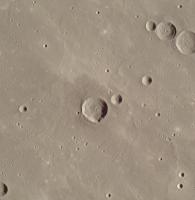
|
A note that our Moon appears similarly red/brown (somewhat less, though), yet the eye appears to compensate for that and make it grey. To human eyes adapted to Mercury's overall hue the surface would probably look more like this:
|
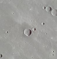
Posted by: ugordan Sep 8 2011, 08:06 PM
One with a very low sun angle, again 2x:
|
Posted by: OWW Sep 8 2011, 08:18 PM
Great work! Looks like that last one is the same area as http://messenger.jhuapl.edu/gallery/sciencePhotos/image.php?page=2&gallery_id=2&image_id=439 released earlier:
Posted by: ugordan Sep 8 2011, 08:32 PM
Yes, it looked familiar to me, particularly that one crater that stands out. Just my luck to stumble onto the same one out of the hundreds of other images...
Posted by: ugordan Sep 8 2011, 09:03 PM
If you orbited high above Mercury, this is what you might see through the window:
|
This should be a fair representation of actual albedo variations on the surface.
Posted by: elakdawalla Sep 9 2011, 01:24 PM

Of course, theirs isn't in color and saturated at the extremes, and yours isn't (if you can follow my double negative
 ) Nice work!
Posted by: Phil Stooke Sep 9 2011, 01:44 PM
Another way to use the global map interface - a mosaic of an area at 25 north, 180 longitude on the western edge of Caloris. Irregular pits in the SE corner and on the eastern rims of the two large craters are volcanic vents. The largest ones were interpreted as such from Mariner 10 data, but many more are known now.
Phil
|
Posted by: kwp Sep 9 2011, 07:38 PM
If memory serves, a great many features on the Moon were believed to be volcanic vents, but few of these assignments survived the "ground truth" of Apollo. How well established is this hypothesis?
Posted by: elakdawalla Sep 9 2011, 08:29 PM
Pretty well. Mercury and the Moon are two very different places, despite their superficial similarities.
Here's one reference: http://adsabs.harvard.edu/abs/2010Sci...329..668P
Posted by: Phil Stooke Sep 9 2011, 09:35 PM
Thanks, Emily!
Yes... on the Moon there was a protracted dispute about the origins of the ubiquitous craters - volcanic or impact - very well described in Don Wilhelms' book "To a Rocky Moon". They were almost all impact craters, as logic and field geology eventually proved. There are volcanic craters on the Moon, but they are very minor features in most areas.
Mercury is different - we see all those circular craters and we know they are from impacts. But we also see irregular pits like the ones I illustrated... and the clincher is, they look different in multispectral data as well. Any individual feature might possibly be misidentified, but the basic picture is well established - lots of impact craters, but quite a lot of irregular volcanic depressions as well.
Phil
Posted by: Phil Stooke Sep 9 2011, 09:43 PM
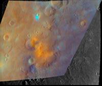
This is MESSENGER flyby false color overlaid on an image of this area - see how the orange patches coincide with the pits, including those on the big crater's rim.
Phil
|
Posted by: ngunn Sep 9 2011, 10:32 PM
It's a reasonable question. Lava has flooded large parts of the surface of both worlds, no doubt about that. More (and more recently) on Mercury than the Moon seems likely. Identifying specific craters as volcanic vents, as opposed to peculiar-looking impact craters formed in an already shattered and unpredictable crater rim, must be less secure. Volcanoes don't have to be upstanding features. On Io most of them are pits. On any planet plains can be flooded with lava from below without leaving surface features identifiable as vents. There are a lot of people looking for volcanos everywhere. Keeping up the scepticism isn't a bad thing to do.
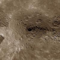
Posted by: Phil Stooke Sep 19 2011, 08:38 PM
Recent south pole images have filled in the whole polar gap in earlier maps. Here's a new mosaic. Hi Steve! You might like this...
Phil
|
Posted by: tanjent Sep 20 2011, 05:05 PM
Is it safe to assume that the dark "bullseye" crater marks the exact position of pole?
I've heard it called the coldest place in the solar system, but I don't know if that is still operative.
It's hard to believe that such a dense metallic body as Mercury is such a poor conductor of heat, both from the interior and from the sun-exposed surfaces.
Posted by: Phil Stooke Sep 20 2011, 05:20 PM
Yes, it's the polar crater called Chao Meng-Fu. The amount of heat available to conduct from the interior would be very small. And of course the core may be large and metallic but the surface is rocky, not metallic. The dusty regolith would be a good insulator, not conducting heat sideways from sunlit areas. And any heat that did get in there is soon radiated away into space. Still, this might not be colder than the coldest lunar shadows, which are now referred to in the same way.
http://planetarynames.wr.usgs.gov/images/H-15.pdf
Link to a PDF file of names of craters in this area, 1.5 MB.
Phil
Posted by: Phil Stooke Sep 25 2011, 07:55 PM
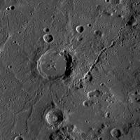
There's lots to see by browsing around that global map, even at this stage. Here is an unusual crater:
|
It looks like an impact crater with a very large central peak. But it falls at the edge of pre-orbital color coverage:
|
(top left) - where it coincides with an orange patch. In the false color composites made by the MESSENGER team this signifies pyroclastics. And the odd crater has no raised rim. Is it really just an extra-large explosive volcanism pit? Or one that completely surrounds the central peak of a regular crater? (some pits do curve part way around the floors of other craters). The big basin in the color image is Beethoven.
Phil
Posted by: elakdawalla Sep 29 2011, 03:45 PM
I just realized I hadn't started this thread in the proper subforum, so I moved it into the MESSENGER subforum.
Posted by: hendric Sep 29 2011, 08:45 PM
Phil,
That to me looks like a Mt. St. Helens-style volcano that blew its top and is regenerating itself. Can't see why that couldn't happen elsewhere in the Solar System.
Posted by: scalbers Oct 8 2011, 05:57 PM
Phil
|
|
Greetings Phil (and tanjent),
Yes, very nice to see this south polar mosaic. It is being included in a series of ongoing revisions to my map as can be seen here:
http://laps.noaa.gov/albers/sos/sos.html#MERCURY
I am showing the South Pole to be just inside the rim of Chao Meng-Fu.
Steve
Posted by: Ittiz Oct 25 2012, 09:08 PM
Have they released any good topographic data yet?
Posted by: djellison Oct 25 2012, 09:24 PM
Lots - http://geo.pds.nasa.gov/missions/messenger/mla.htm - just not a gridded data set yet.
Posted by: Phil Stooke Oct 25 2012, 09:46 PM
It's worth pointing out that the Mercury Laser Altimeter data will only cover the northern hemisphere because of the shape of MESSENGER's orbit. The topography of the whole planet will be done with stereo imaging, at higher resolution but less accurate vertical control. The laser data will then improve the vertical accuracy in the northern hemisphere. The southern hemisphere will get a bit of additional vertical accuracy from limb profiles (including from the early fly-bys) and occultations. The final result will be a good data set but not all from the one instrument.
Phil
Posted by: Ittiz Oct 26 2012, 01:20 PM
Yeah, I've seen that data. So basically it's going to be a wait before we get good topographical data for the whole globe.
Posted by: peter59 Mar 13 2013, 09:41 PM
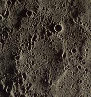
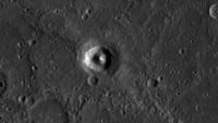
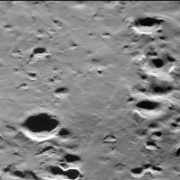
MESSENGER MDIS Release #9 is now available. (2012 day 86 - 2012 day 261)
http://pdsimg.jpl.nasa.gov/index.html
Lots of wonderful images like this:
|
And specific software for quick viewing of this data set:
 MessengerViewer.zip ( 277.73K )
: 1729
MessengerViewer.zip ( 277.73K )
: 1729Enjoy.
Posted by: nprev Mar 13 2013, 10:52 PM
That pic is a jaw-dropper, Peter!
Posted by: Explorer1 Mar 14 2013, 05:22 AM
Absolutely bizarre. And probably the best views we'll get in a long time. Any news about extending the mission past the 17th?
Edit: see http://messenger.jhuapl.edu/gallery/sciencePhotos/image.php?gallery_id=2&image_id=1115 for reasons for the mission to continue: 100% coverage is just the start....
Posted by: peter59 Mar 8 2014, 12:08 PM
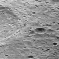
Images from Messenger's narrow angle camera are better and better every batch. If you want to see the surface of Mercury as seen from an airplane window, you can download the latest batch (days 2013-79 to 2013-260) from http://pdsimg.jpl.nasa.gov/index.html, rotate the images 90 degrees to the right, and go on a wonderful journey.
A few randomly selected images (day 2013-189).
|
|
|
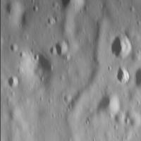
Posted by: peter59 Mar 8 2014, 02:38 PM
Unique close-up look at the chains of secondary craters. Some look partly buried, it is difficult to say whether immediately after they are created, or later.
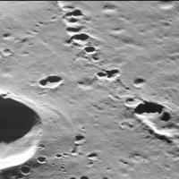
|
|

|
|
Congratulations to the Messenger team for their great job.
Posted by: john_s Mar 8 2014, 04:01 PM
Those secondary crater images are remarkable, and they look different from what I've seen on the moon, IIRC. The craters have been almost engulfed by a ground-hugging flow that is presumably from the same impact that created the craters, but must have reached the area after the craters formed (i.e. tens of seconds later).
John
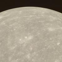
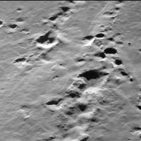
Posted by: peter59 Mar 10 2014, 10:39 PM
You're right, there is no doubt that formed at the same time.
Beautiful view of Mercury.
|
Posted by: peter59 Apr 7 2015, 04:49 PM
I downloaded from PDS the latest batch of images covering the period 078.2014-260.2014. In this batch are a lot of photos taken from a height of less than 30 kilometers. Pictures taken from this altitude are significantly smeared, so on the photographs potentially taken from a height of 5 km should not expect any clear details.
For example, below are presented two images from a height of 29.83 and 29.66 kilometers.
|
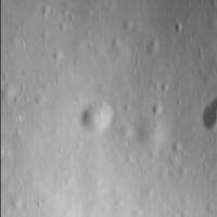
|
Posted by: jccwrt Oct 1 2016, 11:56 PM
A few finds from digging through the MESSENGER archive this weekend:
Crescent of Mercury's southern hemisphere centered on 0 E
https://flic.kr/p/LNJbxK
https://www.flickr.com/photos/132160802@N06/29408486793/sizes/o
Crescent of the southern hemisphere centered on 180 E
https://flic.kr/p/MCL55k
https://www.flickr.com/photos/132160802@N06/29952047051/sizes/o
Crescent horn in the south polar region with the terminator centered on about 60W longitude:
https://flic.kr/p/ML9qSR
https://www.flickr.com/photos/132160802@N06/30035624965/sizes/o
Crescent horn in the south polar region with the terminator centered on about 120W longitude:
https://flic.kr/p/MJ5ZR7
https://www.flickr.com/photos/132160802@N06/30012322436/sizes/o
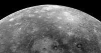
Oblique view over the south pole, with Chao Meng-fu crater in the foreground:
https://flic.kr/p/LKi5ER
https://www.flickr.com/photos/132160802@N06/29369639733/sizes/o
Powered by Invision Power Board (http://www.invisionboard.com)
© Invision Power Services (http://www.invisionpower.com)