Printable Version of Topic
Click here to view this topic in its original format
Unmanned Spaceflight.com _ Messenger _ Mercury Flyby 3
Posted by: Greg Hullender Jul 3 2009, 09:27 PM
We're now just one Mercury year (88 days) from flyby #3, which happens on September 29, 2009, so this seems like a good time to start a thread about it.
http://messenger.jhuapl.edu/index.php
For comparison purposes, it'd be nice if someone (probably someone on the Messenger team) put together a Mercury Map showing what areas will get better coverage from this flyby than from the previous ones. I realize it'll be very similar to flyby #1, but it won't be exactly the same.
After that, it's a long wait until MOI on March 18, 2011. Curiously, that's the same date the New Horizons crosses the orbit of Uranus.
http://pluto.jhuapl.edu/mission/passingplanets/passingPlanets_current.php
--Greg
Posted by: Phil Stooke Jul 3 2009, 10:09 PM
From a global point of view I don't think there will be any significant extension of coverage this time. The important thing will be the chance to extend the area covered by the highest resolution images shortly before and after closest approach. Things happen so fast near closest approach that only a small area can be seen in the highest resolution images. This time it will be possible to image areas not covered at highest resolution before, or to plan images to give good stereo viewing when combined with the earlier images. So, lots of opportunity to do good things, but not really any chance of increasing coverage.
Phil
Posted by: Greg Hullender Jul 4 2009, 04:33 AM
Yes, I understand that. I was hoping someone might make a map that indicated which areas would get improved coverage though. That is, if one were trying to make a Mercury map, which existing areas should one expect to upgrade as a result of this flyby.
Of course, that'll all be obsoleted when Messenger goes into orbit, but that's still a long time from now.
--Greg
Posted by: Phil Stooke Jul 4 2009, 11:04 AM
There's no public information on coverage yet, but it will come.
Phil
Posted by: MarkG Jul 8 2009, 11:32 PM
It will also be interesting if any stereo-pair frames are shceduled.
Any further word on the search for "Vulcanoids"?
--Mark G.
Posted by: Vultur Jul 9 2009, 02:49 PM
Probably a dumb question, but what are Vulcanoids - Mercury-crossing asteroids?
Posted by: mps Jul 9 2009, 05:26 PM
There is an article about vulcanoids in Wikipedia.
Posted by: MarkG Jul 12 2009, 04:21 PM

There is a Wikipedia, but the short answer is that Vulcanoids are a purported group of small bodies orbiting inside Mercury's orbit. Messenger can look for them when at perigee -- looking at an angle away from the sun, but still look at space inside Mercury's orbit.
Posted by: ugordan Jul 12 2009, 04:27 PM
I think you meant perihelion.
Posted by: MarkG Jul 12 2009, 08:46 PM
Sorry to anthropomorphise...
Posted by: Paolo Jul 14 2009, 07:04 AM
By the way, this year marks the 150th anniversary of the publication of Le Verrier's first study of the "intramercurial planet" and of Lescarbault's observed transit of Vulcan across the Sun http://en.wikipedia.org/wiki/Vulcan_(hypothetical_planet)
Posted by: Greg Hullender Aug 3 2009, 05:12 AM
Just half an orbit away now. (Messenger's orbit is currently 116 days). Even if the coverage largely duplicates flyby #1, the phase angle might be different enough to be useful. Does anyone remember how close to the other flybys the Messenger team started posting information for the public?
--Greg
Posted by: dmuller Aug 3 2009, 06:31 AM
I dont recall for sure but if memory serves me right they published their flyby timeline very close to C/A, maybe 2 or 3 weeks in advance.
The press-kit seems to have been published on 13 Sep 08 for the 06 oct 08 flyby
Posted by: stevesliva Aug 3 2009, 03:13 PM
Just got an email with a 5-year milestone press release:
http://messenger.jhuapl.edu/news_room/details.php?id=127
Because of the implementation of solar sailing, the MESSENGER team has not used propellant to correct the cruise trajectory of the spacecraft since December 19, 2007, in advance of the first Mercury flyby, says MESSENGER Mission Systems Engineer Eric Finnegan, of APL.
Neat!
Posted by: Greg Hullender Aug 3 2009, 06:52 PM
That suggests they might be able to have quite the extended mission, when the time comes. I wonder if this counts as the first successful solar sail application? :-)
--Greg
Posted by: Holder of the Two Leashes Aug 20 2009, 04:03 PM
http://messenger.jhuapl.edu/news_room/details.php?id=128
Posted by: Vultur Aug 30 2009, 08:55 PM
It does sound very promising (and it's really a quite amazing thing that they can correct the course using just radiation pressure! That must take very precise calculations...) Imagine what an inner-system probe with actual sails could do...
Posted by: MarkG Sep 8 2009, 01:15 AM
Does anyone know of a detailed diagram of the flyby (#3). I actually want not just the inner stuff, but the stuff from a couple million KM out, to show the interactive dance of the 3-body problem to my son.
Posted by: Hungry4info Sep 8 2009, 02:39 PM
You could download Celestia and the MESSENGER add-on with it. It's a wonderful tool for visualising such things.
Posted by: gndonald Sep 9 2009, 01:42 AM
The page outlining the plans for the third flyby is up.
http://messenger.jhuapl.edu/mer_flyby3.html
Posted by: dmuller Sep 9 2009, 04:03 AM
Haven't been able to find much information yet. According to the site, closest approach is 29Sep2009 17:54:58 EDT, presumably that translates to 29Sep2009 22:54:58 UTC but it doesn't state if it's Earth received time (ERT) or spacecraft event time (SCET). Does anybody know the answer to this?
The latest SPICE kernel I could find was updated on 30 Mar 09 and implies closest approach on 29Sep09 22:53:00 SCET ET at 199.7km altitude and a relative speed of 19,094km/h. That time translates to 29Sep09 22:58:32 ERT UTC. (66 leap seconds and one-way light time of 6min38sec)
EDIT: Assumed that time given is ERT and have updated MESSENGER realtime simulation (http://www.dmuller.net/messenger) accordingly
Posted by: MarkG Sep 10 2009, 04:21 PM
Thanks for the tip on Celestia -- I'm working with it now.
At 8 million km distance today, the crescent of Mercury would be barely resolved by a human eye traveling with Messenger (~2 arc minutes).
Posted by: Holder of the Two Leashes Sep 15 2009, 02:45 PM
Some new diagrams showing picture plans were put up on the main website today.
http://messenger.jhuapl.edu/gallery/sciencePhotos/image.php?gallery_id=2&image_id=325
Posted by: stevesliva Sep 15 2009, 03:46 PM
Which links here -- easy to miss if you focus on diagrams and not text:
http://messenger.jhuapl.edu/target_observ.html
They're doing 30-second stares for spectra and full color filter coverage of some targets they found extra interesting in previous data. Gives a little perspective on what makes this encounter a unique one rather than a repeat.
Posted by: tanjent Sep 15 2009, 04:01 PM
In the related link, showing the simulated position of Messenger relative to Mercury and the sun
http://messenger.jhuapl.edu/whereis/index.php#current_orbit
Messenger seems to be cruising almost "parallel" with the planet while approaching from the night side.
It's hard to tell the relative sizes of things from the sim diagrams, but in the fourth picture it looks like
even now the planet is directly between the spacecraft and the sun. I'd be curious to know - about how
much total time will the spacecraft be spending in Mercury's eclipse during this approach?
Posted by: dmuller Sep 16 2009, 12:14 AM
Yes MESSENGER is cruising more or less directly behind Mercury at the moment (as seen from the Sun). See also the sim images on my site http://www.dmuller.net/messenger (apologies for the "advertisement"), in particular how close the Sun and Mercury are as seen from MESSENGER and the all-dark Mercury enlargement. That can also be seen on the solar system maps on my site: http://www.dmuller.net/realtime/map.php?mt=aboveinner and http://www.dmuller.net/realtime/map.php?mt=eclipticinner. You can also see that the relative speed between MESSENGER and Mercury is now down to less than 22,000km/h. Still too much for an orbit insertion burn, hence this is a flyby and not (yet) the orbit capture.
Mercury will move to the right of the Sun as seen from MESSENGER. View from above and over time (sorry didnt have the time to make an animated gif):
16Sep: http://space.jpl.nasa.gov/cgi-bin/wspace?tbody=1000&vbody=1001&month=9&day=16&year=2009&hour=00&minute=00&fovmul=1&rfov=0.6&bfov=30&porbs=1&showsc=1
19Sep: http://space.jpl.nasa.gov/cgi-bin/wspace?tbody=1000&vbody=1001&month=9&day=19&year=2009&hour=00&minute=00&fovmul=1&rfov=0.6&bfov=30&porbs=1&showsc=1
22Sep: http://space.jpl.nasa.gov/cgi-bin/wspace?tbody=1000&vbody=1001&month=9&day=22&year=2009&hour=00&minute=00&fovmul=1&rfov=0.6&bfov=30&porbs=1&showsc=1
25Sep: http://space.jpl.nasa.gov/cgi-bin/wspace?tbody=1000&vbody=1001&month=9&day=25&year=2009&hour=00&minute=00&fovmul=1&rfov=0.6&bfov=30&porbs=1&showsc=1
28Sep: http://space.jpl.nasa.gov/cgi-bin/wspace?tbody=1000&vbody=1001&month=9&day=28&year=2009&hour=00&minute=00&fovmul=1&rfov=0.6&bfov=30&porbs=1&showsc=1
Flyby: http://space.jpl.nasa.gov/cgi-bin/wspace?tbody=1000&vbody=1001&month=9&day=29&year=2009&hour=23&minute=00&fovmul=1&rfov=0.6&bfov=30&porbs=1&showsc=1
Posted by: tanjent Sep 16 2009, 09:30 AM
Well then it seems like for the moment I should put aside my hopes of an eclipse picture taken at some point
from which the angular diameter of the planet just about matches that of the Sun. I don't know what the science
value of such a shot would be, but it would definitely be a memorable sight to see. Perhaps the orbital phase
will present opportunities for this kind of a photograph.
Posted by: djellison Sep 16 2009, 10:21 AM
Hmm - I wouldn't fancy that observation too much - being THAT close to the sun and then you're pointing the entire instrument deck sunward? No thanks.
Posted by: dmuller Sep 16 2009, 01:20 PM
That would be the shot:
|
Source: http://space.jpl.nasa.gov/cgi-bin/wspace?tbody=199&vbody=-236&month=9&day=16&year=2009&hour=12&minute=00&fovmul=1&rfov=10&bfov=30&porbs=1&showsc=1
Mercury about dead-center in the sun on 16 Sep at 12noon UTC. The Sun's apparent size is about 15 times larger than that of Mercury.
Posted by: gndonald Sep 17 2009, 12:15 AM
http://messenger.jhuapl.edu/news_room/details.php?id=129
They still have not released a press kit for this. It looks like it won't be released until the 23rd when they have the teleconference.
Posted by: tanjent Sep 17 2009, 01:00 AM
The mission website discussion of the orbital phase does not say much about how the mission will end.
http://messenger.jhuapl.edu/the_mission/orbit.html
Maintaining the orbit will require continued fuel consumption.
The page does not reveal if, after 12 months or 2 solar days they expect to simply run the tank dry and
lose contact with the spacecraft, or what other sort of ending will follow. I have heard no
proposals for extending the mission, but somewhere near the end - after completion of all the major objectives
a moment may come when otherwise unacceptable risks can be considered. My little suggestion represents just one
possibility - maybe not a very strong candidate, but if the mission can end with an attention-grabbing "goodbye" shot,
there would be some value in that.
Dmuller, thanks for pointing out the big advantage in apparent size still enjoyed by the sun at the present time.
Posted by: tedstryk Sep 20 2009, 12:56 PM
While we are waiting, I have added my Mariner 10 set to my blog http://planetimages.blogspot.com/2009/09/mariner-10-at-mercury.html
Posted by: 4th rock from the sun Sep 21 2009, 11:58 AM
ExcellentMariner 10 images! And a very nice job of bringing out the subtle color differences from a very limited dataset. They match very well with the Messenger global views.
Posted by: tedstryk Sep 21 2009, 02:26 PM
Thanks. I made them just before the first Messenger flyby. The correlation isn't perfect, but the filter combinations here are much more blue-shifted. The south pole view is just a rough overlay based on the color seen in the first two images.
Posted by: Greg Hullender Sep 21 2009, 06:15 PM
James Leary has discussed a possible extended mission:
http://www.nasa.gov/missions/highlights/webcasts/elv/messenger/event2-QandA-transcript.html
However, all he said was that they mght get the spacecraft into a slightly lower orbit so as to get slightly better pictures. He didn't suggest that Messenger would ultimately impact Mercury.
Solomon's "Mercury After Messenger" is a very cool read all by itself, and he suggets an XM for Messenger might be just a single Earth year:
http://www.spacepolicyonline.com/pages/images/stories/PSDS_IP1_Solomon_MESSENGER.pdf
Despite the title, it's mostly about what Messenger will do at Mercury, but it suggests that after Messenger and Bepi-Colombo, there won't be a lot gained by another orbiter. The next step would have to be a lander or sample-return mission.
--Greg
Posted by: Greg Hullender Sep 22 2009, 03:48 PM
The Messenger team will be doing a press conference tomorrow to discuss next week's flyby:
http://messenger.jhuapl.edu/news_room/details.php?id=130
This appears to be limited to press, but perhaps someone like Emily will be able to report back to us. :-)
--Greg
Posted by: Greg Hullender Sep 22 2009, 03:56 PM
There is a nice map, just posted today, showing the planned imaging coverage:
http://messenger.jhuapl.edu/gallery/sciencePhotos/image.php?gallery_id=2&image_id=326
Note that this suggests that Flyby #3 will cover more than half of the never-seen terrain.
I also note that the areas marked for Flyby #1 and Flyby #2 are backwards. Flyby #1 coverage is actually the area outlined in red on the image and Flyby #2 is outlined in blue, as we can see from the Flyby #2 coverage plan:
http://messenger.jhuapl.edu/gallery/sciencePhotos/pics/M2_new_coverage_Sep08.jpg
We knew that this flyby would be very similar to Flyby #1 -- so much that some of us had worried there would be nothing new to see at all. What's surprising (to me, anyway) is that the coverage on approach is much larger and significantly shifted compared to flyby #1 (and this is where almost all the new coverage comes from) but the coverage on departure is almost the same as for Flyby #1. Wonder why so much difference between the two?
--Greg
Posted by: elakdawalla Sep 22 2009, 04:18 PM
Gosh, I'd missed the fact it was a telecon, not TV briefing. I'm glad you mentioned it -- got my request for the phone number in in time! I'll certainly be reporting on it. Today I'm working on my usual preview timeline.
--Emily
Posted by: elakdawalla Sep 22 2009, 06:51 PM
» Sun illuminates 95 to 275°E
Flyby 2: October 6, 2008
» Sun illuminates 273 to 93°E
Flyby 3: September 29, 2009
» Sun illuminates 270 to 90°E
The two maps you point to are just centered on different longitudes.
I think maybe the reason the approach crescents are different is because on flyby 2 MESSENGER was coming in from a direction farther from the Sun -- its orbit has shrunk since then. But I don't have the best instinct for orbital geometry. If I don't think of a better question to ask, I may ask this one tomorrow.
--Emily
Posted by: Greg Hullender Sep 22 2009, 07:35 PM
The two maps you point to are just centered on different longitudes.
Oops!
Actually, taking a look at the plots of the orbit, I think I can see it now:
This was flyby #2
http://messenger.jhuapl.edu/the_mission/MESSENGERTimeline/MercuryFlyby2Files/Mercury2AboveNorthPoleFull.jpg
And this is flyby #3
http://messenger.jhuapl.edu/the_mission/MESSENGERTimeline/MercuryFlyby3Files/Mercury3AboveNorthPoleFull.jpg
The orbit "bends" a good bit more this time -- which makes sense, as Messenger is losing energy with each flyby. It's probably just a coincidence that the outbound path seems to be more or less the same (with respect to the planet surface) as it was for flyby #2. Especially since this flyby seems to be about 25 degrees further around Mercury's orbit than the last two were.
http://messenger.jhuapl.edu/the_mission/trajectory.html
Shoot. Just as I typed all this, the Messenger folks released this:
So I guess that's the answer. I'd still like to know exactly what percentage of Mercury will remain unimaged after this flyby . . .
--Greg
Posted by: dmuller Sep 23 2009, 01:08 AM
Does anybody have the flyby timeline in spreadsheet form? Going through the encounter sim just drives me nuts, plus it doesn't match with any other info i have :-(
Posted by: Greg Hullender Sep 23 2009, 06:26 PM
Another press release today:
http://messenger.jhuapl.edu/news_room/details.php?id=132
A couple of things I hadn't realized before:
1) This is their last chance to study the magneto tail in the equatorial plane.
2) The flyby images are higher-resolution near the equator than any pictures Messenger will take later.
3) They are still looking for possible moons, down to radius 100m.
--Greg
Posted by: Greg Hullender Sep 25 2009, 06:24 PM
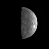
Another Messenger update, this one has a new photo.
http://messenger.jhuapl.edu/mer_flyby3.html
Given the approach image we saw before, I think that means the lighted part of this crescent is mostly terrain that has never been imaged before, so that's kind of cool. Interesting-looking bright crater near the top.
--Greg
Posted by: kohare Sep 26 2009, 12:56 AM
They still have not released a press kit for this. It looks like it won't be released until the 23rd when they have the teleconference.
http://messenger.jhuapl.edu/news_room/M3FlbybyPK_Draft3_92309.pdf now available. File title seems to indicate it's draft 3 from 23 September, so maybe it will be updated in a a final release??
Posted by: dmuller Sep 26 2009, 01:56 AM
I have uploaded http://www.planetary.org/news/2009/0923_MESSENGERs_Final_Flyby_of_Mercury_Old.html onto my realtime simulation at http://www.dmuller.net/messenger. Less than 4 days to go.
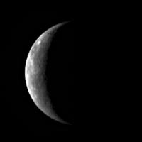
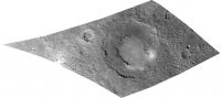
Posted by: Phil Stooke Sep 27 2009, 03:51 AM
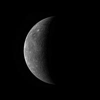
This is the first Mercury 3 image release enlarged and with the terminator brightened. The bright crater was seen last time too.
Phil
|
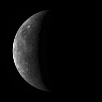
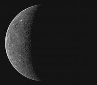
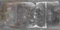
Posted by: Phil Stooke Sep 28 2009, 10:51 AM
The latest image, enlarged, terminator brightened and sharpened.
Phil
|
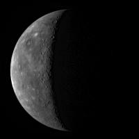
Posted by: Hungry4info Sep 29 2009, 01:55 PM
Latest image from the website, showing essentially the same thing as Phil Stooke was able to get by sharpening the image before.
http://messenger.jhuapl.edu/gallery/sciencePhotos/pics/CN0162589824M_RA_3_web.png
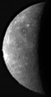
Posted by: Phil Stooke Sep 29 2009, 02:25 PM
And here's what he gets by enlarging, selectively brightening and sharpening this new image:
|
Phil
Posted by: Ant103 Sep 29 2009, 08:08 PM
My own sharpenning of the last picture of Messenger.
Just a wavelett sharpen 
|
Posted by: HughFromAlice Sep 30 2009, 11:01 AM
I just went to the Messenger site to see if any new pics down yet. But no. Although I liked yours, I thought I would take the "old" one and have a bit more of a look at the terminator while we're waiting.
|
Pardon my ignorance,but what's a wavelett????

Posted by: ngunn Sep 30 2009, 11:14 AM
Surprised no-one has commented on this glitch here:
http://www.planetary.org/blog/article/00002128/
I am hoping that whatever it was wasn't caused by something in the space environment close to Mercury, but was rather a purely internal programming thing that can be avoided by adjusting procedures. If it was a totally random event the timing is extraordinary (but not unprecedented - remember Iapetus). Anybody know anything more?
Posted by: peter59 Sep 30 2009, 12:34 PM
Better view into new territory.
http://messenger.jhuapl.edu/gallery/sciencePhotos/pics/CW0162741055G_RA_3_web.png
Posted by: djellison Sep 30 2009, 12:38 PM
According to Twitter - the first thought is that they were on the wrong Antenna.
http://twitter.com/messenger2011
Posted by: ngunn Sep 30 2009, 01:20 PM
That's reassuring, thanks Doug.
I think the latest image via peter59 already closes the gap at low latitudes. If I'm not mistaken the bright crater on the limb near the equator with the prominent northward trending ray is on the other side of 'terra incognita'. Also we can already see converging E-W rays in the southern hemisphere from the very prominent crater up ahead.
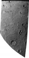
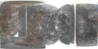
Posted by: Phil Stooke Sep 30 2009, 01:28 PM
This is the new view converted to an (approximate) stereographic projection. That makes craters near the limb circular so you can interpret features more easily. Very extensive smooth plains in the north.
Phil
|
Posted by: elakdawalla Sep 30 2009, 01:59 PM
The latest, via Twitter, is that MESSENGER safed just before closest approach. No high-res images on departure  But since the flyby didn't involve any thruster firing, the gravity assist should have been successful. All approach imaging should have been done, so that last gore should be filled.
Posted by: Juramike Sep 30 2009, 02:17 PM
It also makes it look like Mercury just came out of the dryer.

Posted by: Hungry4info Sep 30 2009, 02:47 PM
New, nice image.
http://messenger.jhuapl.edu/gallery/sciencePhotos/pics/CN0162744001M_RA_3_web.png
Posted by: ugordan Sep 30 2009, 03:08 PM
Classic.
Posted by: elakdawalla Sep 30 2009, 03:56 PM

I'm very happy that their latest release is of http://messenger.jhuapl.edu/gallery/sciencePhotos/image.php?page=1&gallery_id=2&image_id=332, which was only half-seen on the previous flyby.
Posted by: Stu Sep 30 2009, 04:34 PM
That just clinches it: there's an alien ship out there, tailing our spaceprobes, with a load of mischevious, drunk, giggling ET teenagers inside it, just waiting to fire their "Put little toy alien spacecraft into safe mode at just the worst possible moment!" ray at them...
Pesky alien kids!!! 
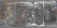
Posted by: Phil Stooke Sep 30 2009, 04:46 PM
A couple more reprojections:
|
|
Phil
Posted by: mps Sep 30 2009, 06:57 PM
Yes, back in the old days, we didn't know to fear safe modes during flybys. But this time I did...
Was it actually first safe mode event for MESSENGER?
Posted by: antipode Oct 1 2009, 12:31 AM
Some nice crater chains approx radial to that double ringed basin.
Does it have a name?
P
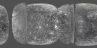
Posted by: nprev Oct 1 2009, 12:41 AM
Great reprojs, Phil!
Noticed a crater that's apparently been buried by a lava flow (arrowed).

|
Posted by: Phil Stooke Oct 1 2009, 12:44 AM
Yes, and a similarly buried big double-ring basin near the top of the same image.
Phil
Posted by: nprev Oct 1 2009, 12:53 AM
I was struck by this one's symmetry...didn't have much time to melt down the rim walls, did it? Interesting.
Posted by: JohnVV Oct 1 2009, 07:17 AM
it will be nice when the images get here
http://pds-imaging.jpl.nasa.gov/Admin/resources/cd_messenger.html
and i can remove the stripe from my map
Posted by: tanjent Oct 1 2009, 01:46 PM
OK, no serious harm done this time but I sure hope there won't be a flyby #4 in March 2011.
Posted by: Sunspot Oct 1 2009, 01:49 PM
Maybe this story can shed some light on it? http://science.nasa.gov/headlines/y2009/29sep_cosmicrays.htm More cosmic rays.
Posted by: ugordan Oct 1 2009, 02:59 PM
I suspect they'll disable a bunch of fault handling before executing the MOI burn, the same way New Horizons plans to disable most of onboard fault protection during the Pluto flyby.
Posted by: elakdawalla Oct 1 2009, 03:05 PM
Yeah -- fault handling on gravity assist flybys or opportunistic encounters is way, way different than for planned science flybys. Remember how OSIRIS on Rosetta safed before the Steins flyby, and how Dawn safed during its Mars flyby. On such encounters science is way, way down the list compared to spacecraft health. If the flyby is just for science, as with NH at Pluto and Mariner 10's Mercury flybys, then they disable a lot of the fault protection.
--Emily
Posted by: tanjent Oct 1 2009, 03:07 PM
Galactic cosmic rays could have impacted the spacecraft at any time, regardless of its position relative to the planet.
The fact that this event came just as Messenger entered Mercury's shadow offers a strong hint that it was somehow
related to that transition. That said, I guess some of those 7000+ stored flyby commands could have been corrupted
by a CR incident, and we would not have discovered it until it came time to execute them.
Note - This was WRT Sunspot's earlier post. The subsequent posts are acknowledged with some relief.
Posted by: ugordan Oct 1 2009, 03:15 PM
by a CR incident, and we would not have discovered it until it came time to execute them.
Commands are not typically as data intensive as science data so it's cheap to have several backup copies of them onboard. That goes for the flight software itself. There are ways very high priority maneuvers can be protected against memory and even processor trips via cosmic rays and several computers with redundant processing is one for example.
Posted by: mcaplinger Oct 1 2009, 03:19 PM
by a CR incident, and we would not have discovered it until it came time to execute them.
Error correction both in uplink and memory make this quite unlikely.
Most safe mode entries have to do with loss of attitude reference. Flybys often provide opportunities for unexpected star camera problems from planetlight or occultations.
Posted by: scalbers Oct 11 2009, 02:23 PM
Here's a version of my map with the Flyby 3 sliver added in. This uses WAC and NAC images. I plan to add the Mariner map & radar data back in and then try adding one of VP's mosaics.
|
That's the latest,
Steve
Posted by: scalbers Oct 11 2009, 04:11 PM
And here is that version...
|
Steve
Posted by: Decepticon Oct 12 2009, 12:40 AM
Steve great work!
Do you have a Messenger Map Only version? (A strange request from my father)
Posted by: Hungry4info Oct 12 2009, 01:47 AM
I can understand Decepticon's father's request. With all this wonderful MESSENGER data, the Mariner 10 imagery seems... undesired.
Posted by: JohnVV Oct 12 2009, 08:16 PM
i have a flyby 1 and 2 only map on a dvd. If you want i can post it
for a preview you can look at the map on the celestia motherlode
it is combined with the very old map .
http://celestiamotherlode.net/catalog/show_addon_details.php?addon_id=1244
Posted by: scalbers Oct 15 2009, 05:25 PM
Greetings all. I can appreciate and muse about various aspects of this request. I did a MESSENGER only map for Emily I think with the first 2 flybys. The MESSENGER site used to show their map without the Mariner, though they now have it added in. From what I've seen so far the Mariner 10 imagery is still of higher resolution near longitude 135W and near the South Pole, so a "best of all" map should maybe still have it in. I tend to keep a long term view of historical context perhaps. Nonetheless it's interesting to see what a MESSENGER only map looks like and it can of course be compared to the "both" map (also with radar).
Right now I happen to be in between two vacation trips, but I'll consider this in a bit. It might be fairly simple to add a switch that turns off the Mariner and radar imagery in my IDL procedure.
Catch you later,
Steve
Posted by: tedstryk Oct 15 2009, 05:53 PM
The Mariner 10 data that really looks different is the south polar mosaic because it is a 1970s creation. Making a clean, modern version of it is on my to-do list.
Posted by: scalbers Oct 24 2009, 05:22 PM
Greetings, here is a MESSENGER only version that Decepticon's father may want to look at:
|
Posted by: scalbers Oct 24 2009, 05:45 PM
...and an updated version of the one including Mariner and radar data for comparison:
|
Steve
Posted by: Decepticon Oct 25 2009, 02:59 AM
WOW! Thanks scalbers!
Posted by: Phil Stooke Oct 27 2009, 12:49 PM
The latest release, a distant view - enlarged and the terminator brightened.
Phil
|
Posted by: Paolo Jul 16 2010, 07:30 AM
apologies for resurrecting this old thread, but Science express had yesterday three new preprints on scientific results from M3 (as usual, full papers are available only to subscribers)
http://www.sciencemag.org/cgi/content/abstract/science.1188186
http://www.sciencemag.org/cgi/content/abstract/science.1188067
http://www.sciencemag.org/cgi/content/abstract/science.1188572
Powered by Invision Power Board (http://www.invisionboard.com)
© Invision Power Services (http://www.invisionpower.com)