Printable Version of Topic
Click here to view this topic in its original format
Unmanned Spaceflight.com _ Earth Observations _ Processed images from Earth orbiting spacecraft
Posted by: Bjorn Jonsson Nov 15 2012, 12:37 AM
For some reason it didn't come to my attention until recently (less than a year ago) that the entire Landsat imagery plus a lot of data from other Earth orbiting spacecraft is freely available for download at http://earthexplorer.usgs.gov/ . Maybe this is because for a long time it was more difficult to find good and freely available global maps (or get data to make maps) of the Earth than it was for other planets/satellites - I somehow was under the impression that the vast majority of Earth imagery was commercial.
The Earth is visually a really spectacular planet (in my opinion possibly even the most photogenic body in the entire solar system) so it's possible to get spectacular results by downloading some of this data. The data can be selected by spacecraft, instrument, location, months/years, cloud cover percentage etc.
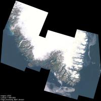
Data is available from several Landsat satellites but the best data is from Landsat 7; Landsat 5 is also good. This is multispectral data with a resolution of 30 meters/pixel. Here is an experimental and spectacular 12 frame mosaic showing southern Greenland (10% the original size):
|
The full size version (19000 pixels square) plus additional information can be seen in http://www.planetary.org/blogs/guest-blogs/20121113-landsat-greenland-jonsson.html at the http://www.planetary.org. This image shows a spectacular and complex 'maze' of long and narrow fjords and islands, narrow valleys flanked by steep mountains, glaciers and glacial rivers, countless lakes and ponds and in general a landscape that has been shaped by advancing and retreating glaciers, depending on climate. One important thing to note is that overall this data turned out to be easier to process than is typical for data from other planets.
Posted by: Bjorn Jonsson Jun 8 2013, 06:15 PM
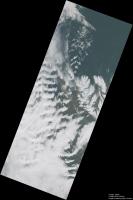
Landsat 8 was launched in February. Following a period of checkouts and calibrations it started regular operations in late May. Below is a mosaic of three Landsat 8 images showing a part of northern Iceland. The full size version (12020x18130 pixels) can be http://www.mmedia.is/bjj/images/landsat8_iceland_20130604.jpg, the version below is 30% of the original size:
|
The images were obtained on June 4, 2013 near local noon. The resolution of the full size version is 30 m/pixel. At this time the weather was characterized by strong southerly winds and mountain waves are prominent, especially left of center.
The Landsat 8 image data is of significantly higher quality than earlier Landsat data. In particular, the images are 16 bits which is significant when dealing with high dynamic range scenes where glaciers, snow and clouds are visible together with relatively dark terrain. In this case, the clouds were typically brighter than the dark terrain by a factor of ~5 in the original images . Some areas have relatively fresh snow that is even brighter. The version above has been processed to brighten the dark terrain without losing too much of the detailed structure visible in the clouds.
These images are made available shortly after acquisition, for example I downloaded some images only several hours after they were taken.
Posted by: scalbers Feb 13 2015, 09:49 PM
There are some other satellites where color processing can be considered of the land surface and clouds. This includes quite a few spectral bands in DISCOVR - https://directory.eoportal.org/web/eoportal/satellite-missions/d/dscovr (near future - as discussed in http://www.unmannedspaceflight.com/index.php?showtopic=1992), VIIRS, and GOES-R ABI (future).
So for the present, we can consider VIIRS polar orbiter also having http://rammb.cira.colostate.edu/projects/npp/VIIRS_bands_and_bandwidths.pdf.
GOES-R ABI will have good rapid update frequency (just minutes) in geosynchronous orbit, though it only has http://www.goes-r.gov/spacesegment/ABI-tech-summary.html.
Some other geosynchronous weather satellites (apart from GOES) have or will have multiple visible bands.
Steve
Posted by: Sean Oct 28 2017, 12:01 AM
Here are some processed, retimed sequences from ISS courtesy of NASA & Earth Science and Remote Sensing Unit...
https://flic.kr/p/YH5m7q
https://flic.kr/p/ZLRPZW
https://flic.kr/p/FWFpZP
Posted by: monty python Oct 28 2017, 06:01 AM
THANK YOU! Works of art.
Posted by: ugordan Oct 29 2017, 12:20 PM

Beautiful videos, but the "Nadir" one has me scratching my head. Based on the inclination of the ISS orbit and the ground track motion over Italy, it makes me think the sequence is actually running backwards in time?
Also, in the aurora video, it's almost just as fascinating to look for satellites moving in the background as dim dots as well as a sunglint off of one at 11 seconds into the video.
Posted by: Sean Oct 29 2017, 12:28 PM
It is indeed running backwards. I should have specified this, sorry. It took an age to get this rendered and it slipped my mind. Purely an aesthetic choice.
Posted by: nprev Nov 1 2017, 11:47 PM
Spellbinding, Sean. 
Posted by: Sean Dec 31 2017, 04:45 PM
Moonlight Flight
https://flic.kr/p/21GLeor
https://youtu.be/XNHqYB82a4M
Expedition 53
November 5, 2017 from 22:29:56 to 23:03:24 GMT
From the South Atlantic Ocean to Kazakhstan
Original timelapse extended x3, many repairs & processed.
Kangaru by Jóhann Jóhannsson
Posted by: monty python Jan 1 2018, 08:30 AM
Very nice. Thank You!
Posted by: Sean Jan 2 2018, 01:28 AM
Here is the same source material re-tweened in 60fps to approximate real time based on 1,998 source frame count & 22:29:56 to 23:03:24 time stamps
3 minute sequence on Flickr...
https://flic.kr/p/221C4TS
https://youtu.be/nVtuCyVQk1k
I took care to choose footage that contained no lightning as that would spoil the intent, though it is possible to repair those flashes before tweening and re-insert them during real time pass.
Posted by: Sean Jan 3 2018, 04:27 AM
Africa to Japan
https://flic.kr/p/238jif4
Expedition 34
January 4, 2013 from 05:23:00 to 05:56:16 GMT
From the border of Congo and the Democratic Republic of Congo to just east of Japan.
Original timelapse extended x5 & processed.
'Odi et Amo' by Jóhann Jóhannsson
https://www.youtube.com/watch?v=OOXPVVA6P7U
Source extended x60 to approximate real time ( 3 minute excerpt )
https://flic.kr/p/21MYK5r
https://youtu.be/3mndCBfAT7c
Finally after a 22 hour process & 3 hour upload
https://youtu.be/9mCgb-ff3U0
'Somnus' by Phaeleh
Posted by: Sean Feb 5 2018, 07:03 PM
I made a movie.
https://flic.kr/p/243PBc1
https://youtu.be/M8vsELTVZSQ
Music by Phaeleh
Orbit is a real time reconstruction of time lapse photography taken on board the International Space Station by NASA's Earth Science & Remote Sensing Unit.
The structure of the film is built around a nested selection of Phaeleh's last three albums; Lost Time, Illusion of the Tale & Somnus. The tone & pacing of each track influenced the choice of material used.
Typically each time lapse sequence was photographed at 1 frame per second.
Each sequence was processed in Photoshop. A dirtmap was made in order to repair dust, blemishes and hot pixel artifacts that would otherwise confuse the re-timing phase of the workflow resulting in strobes and distracting blurs.
Image processing techniques were used to emphasize features on the Earth's surface. Every sequence consists of a number of layers that when masked, processed & blended correctly produce the final look of each shot.
To make sure each sequence was recreated faithfully to the actual rate of speed observed I referenced time-stamps on the first and last frame in the sequence and used frame interpolation software to produce the other 59 frames.
The length of the film is exactly the length of time it takes ISS to orbit the Earth once, 92 minutes & 39 seconds.
Posted by: Sean Feb 8 2018, 08:36 PM
'Cebile'
Tropical Cyclone Cebile from January 30th as photographed by Himawari8 [time-lapse] & ISS ESRSU [ real time time-lapse reconstruct ]
https://flic.kr/p/236uJKN
https://www.youtube.com/watch?v=STyDjyD8bTQ
Posted by: Sean Feb 20 2018, 06:44 PM
Volcano Sinabung time-lapse interpolation from Himawari8
https://flic.kr/p/21LCLN7
Posted by: PaulH51 Feb 21 2018, 03:53 AM
Thanks for that Sean, only about 300km from my place
Posted by: scalbers Feb 25 2018, 05:29 PM
Sean - wonderful Cebile animations with the stadium view. The volcano is pretty nice as well. A couple of things I've been studying recently are forest fires and dust storms if you ever come across these phenomena.
Posted by: Sean Mar 15 2018, 01:22 PM
Eye of Gita
https://flic.kr/p/247LyiQ
https://www.youtube.com/watch?v=CI4T5XCqMDc
Upscaled, cropped, resized to 4k, processed and retimed.
Posted by: PaulH51 Mar 16 2018, 08:31 AM
Nice Thanks Sean
Posted by: Sean Mar 16 2018, 02:20 PM
Thanks Paul!
GITA
https://flic.kr/p/H6n8qu
https://www.youtube.com/watch?v=XHsYixXUyYI
Filled in time-lapse gaps for the Himawari footage before re-timing.
For the new real time shot I repaired, stabilized, de-flickered, processed, cropped & retimed.
Posted by: Sean Mar 18 2018, 05:27 PM
NASA Earth posted this image recently so I decided to clean all the crud from ISS windows & reduce jpg artifacts...
https://flic.kr/p/FCqdza
Posted by: scalbers Mar 31 2018, 10:08 PM
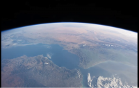
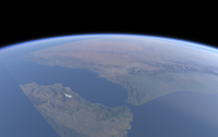
Really neat ORBIT movie from Sean that I'm just catching up on - particularly with the leisurely real-time aspect. Here is an evolving attempt at rendering a portion of the Gibraltar view at about 2:05. Aiming at true color/contrast the image looks relatively subdued. The snow on the mountains helps provide reference points to compare locations.
|
Also for comparison is a frame from the NASA version of the video:
|
https://youtu.be/M8vsELTVZSQ
Posted by: Sean May 19 2018, 06:33 PM
Thanks Steve... that's pretty close to the source... obviously 'Orbit' is quite processed which I hope doesn't burn your retina much. I'd be interested to know what global maps you are using.
Cloudheads mosaic + details. ( stitched, processed, repaired )
https://flic.kr/p/25WMMDa
https://flic.kr/p/24yFZhY
https://flic.kr/p/24yFYLY
https://flic.kr/p/25WMKWx
Posted by: scalbers May 20 2018, 07:25 PM
Nice cloud view Sean - this type of image would be interesting to holistically check atmospheric model output. The simulated Gibraltar images are driven with land surface albedo derived from 500m Blue Marble Next Generation image data. Terrain is from an old 1km USGS database. I added in some synthetic aerosols, though there are models that try to produce them in real-time.
Posted by: scalbers Jul 19 2018, 03:30 PM
This simulated version of Gibraltar has improved land brightness compared with post #22. The radiance calculations for scattered light and reflected light are now being handled more consistently.
|
Posted by: Sean Aug 4 2018, 01:36 PM
Saudi Cloudscape from ISS expedition 47
https://flic.kr/p/MEvVyW
https://flic.kr/p/29HSUTJ
8 frame composite made from raw file with some fill & repair
*updated with correct exposure
Posted by: Sean Aug 7 2018, 06:25 PM
Here is a very quick test of a retimed time-lapse made from raw files.... big quality improvement over the standard JPG compressed files.
https://flic.kr/p/29Udxsr
https://youtu.be/ydmtn9CEmAg
Nile Night
https://flic.kr/p/29UgtKF
Posted by: Sean Sep 3 2018, 11:40 AM
Sky River
https://flic.kr/p/NzVo8y
https://youtu.be/Nd2QQ4rZagY & https://vimeo.com/287986661
Posted by: monty python Sep 4 2018, 07:21 AM
Sean, thank you so much. ART!
Posted by: Sean Sep 10 2018, 02:36 AM
https://flic.kr/p/29Qm3T3
4k on https://youtu.be/G4W5ljxPq98 & https://vimeo.com/289013988
https://flic.kr/p/28akS7S
Posted by: Sean Sep 10 2018, 09:57 PM
9th September 2018
https://flic.kr/p/29yAvAv
4k on https://www.youtube.com/watch?v=X0y62Pd3lSM & https://vimeo.com/289158150
Posted by: Sean Sep 11 2018, 09:46 PM
https://flic.kr/p/2aUsut5
4k on https://youtu.be/zu3h6dDBFBw & https://vimeo.com/289309818
Posted by: Sean Sep 17 2018, 10:07 AM
https://flic.kr/p/28papKu
6 days of Typhoon Mangkhut
4k version on https://vimeo.com/290241206
Posted by: Sean Sep 17 2018, 06:30 PM
Typhoon Mangkhut, projected, 8k
https://flic.kr/p/29MyTCn
September 13th
Posted by: Sean Sep 17 2018, 09:39 PM
Typhoon Mangkhut projected [animation]
https://flic.kr/p/MqgrXK
September 13
Posted by: scalbers Sep 27 2018, 08:03 PM
Looks very nice Sean. I wonder if these recent examples are also using time interpolation (optical flow)?
Posted by: Sean Sep 27 2018, 10:06 PM
Yes, all of my Himawari animations are interpolated.
Posted by: scalbers Oct 13 2018, 05:24 PM
Nice to know. FYI, the GOES-16 mesoscale sectors have images for Hurricane Michael in one-minute timesteps. I suppose one can downscale the time, zooming into the eye to see time steps of just seconds.
There is some experimental GOES-17 imagery (not yet public) that has real images on a 6-second time scale.
GOES-16 "raw" image data is available on the AWS cloud if one wants to get this type of data - perhaps you already are.
Posted by: Sean Nov 22 2018, 09:15 PM
Ah that is good information to have Steve, thanks. I may ping you later on that.
For those that rightfully avoid social media I thought I would share a time-lapse of the recent Progress re-supply launch...
https://flic.kr/p/2d1NsMY
https://www.youtube.com/watch?v=w3PXah9WLEU
Posted by: John Moore Nov 22 2018, 09:26 PM
Super, Seán.
John
Posted by: MahFL Nov 23 2018, 12:54 AM
There is some experimental GOES-17 imagery (not yet public) that has real images on a 6-second time scale.
GOES-16 "raw" image data is available on the AWS cloud if one want to get this type of data - perhaps you already are.
They can do 30 second updates if they use both Meso sectors on the same target.
Posted by: Sean Nov 25 2018, 02:36 AM
Rocket Launch
https://flic.kr/p/2c2XqMm
https://youtu.be/1S0CTtY8Qa0
Progress MS-10 resupply ship bound for ISS launches from Baikonur Cosmodrome in Kazakhstan, as seen from the International Space Station on November 16th, 2018.
Posted by: wildespace Nov 25 2018, 07:54 AM
Great work as always, Sean. (The last video you linked only goes up to 1080p though)
Individual images from the timelapse can be found here: https://eol.jsc.nasa.gov/SearchPhotos/ShowQueryResults-CoolIris.pl?results=154306473171881
It's interesting to analyse the images to spot specific stages of the launch.
Here's the moment the rocket discarded its four strap-on boosters: http://eol.jsc.nasa.gov/SearchPhotos/photo.pl?mission=ISS057&roll=E&frame=100819
|
Third stage ignition: https://eol.jsc.nasa.gov/SearchPhotos/photo.pl?mission=ISS057&roll=E&frame=101073
|
The second (core) stage burn up on reentry: https://eol.jsc.nasa.gov/SearchPhotos/photo.pl?mission=ISS057&roll=E&frame=101473
|
You can see the pieces of it trailing behind. Very spectatuclar!
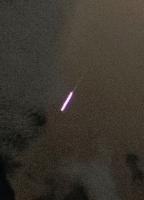
Oh, and the camera also caught a couple of meteors: https://eol.jsc.nasa.gov/SearchPhotos/photo.pl?mission=ISS057&roll=E&frame=101828
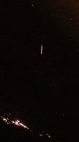
|
https://eol.jsc.nasa.gov/SearchPhotos/photo.pl?mission=ISS057&roll=E&frame=100595
|
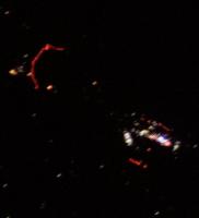
I'm curious what those red lights on the ground are: https://eol.jsc.nasa.gov/SearchPhotos/photo.pl?mission=ISS057&roll=E&frame=101803
|
Posted by: vikingmars Nov 25 2018, 08:57 AM
Thank you so much Sean for the very IMPRESSIVE video and for Wildespace to outline the most important visual steps of the launch
Congratulations for both of you 
Posted by: Sean Nov 25 2018, 11:07 AM
Thanks for that breakdown Wildespace.
It takes Youtube a while to process 4k versions but it should show up eventually.
Re-watching this I can spot a number of interpolation glitches I will need to repair so there will probably be a v2 when I can find the time.
*Update*
Youtube 4k is still pending... here is the https://vimeo.com/302734559
Posted by: avisolo Nov 26 2018, 08:16 AM
Earth photographed from NASA's Lunar Orbiter V in 1967:
https://www.flickr.com/photos/47222633@N05/46030301661/
Posted by: Sean Nov 26 2018, 08:52 PM
Italian Blue
https://flic.kr/p/29n3m6U
https://youtu.be/bhmPi5mJFdU
Posted by: Sean Nov 26 2018, 09:00 PM
In The Emerald
https://flic.kr/p/29qvG4s
https://youtu.be/BgKc7Dy8Fvo
Posted by: Sean Nov 26 2018, 09:01 PM
Star Sky
https://flic.kr/p/2c63jwz
https://youtu.be/y-bcBwlVwek
Posted by: scalbers Jan 19 2019, 01:26 AM
An enhanced view of the sun glint in the Pacific today from the CIRA Slider Website:
http://rammb-slider.cira.colostate.edu/?sat=goes-16&z=1&im=12&ts=1&st=20190118220034&et=20190119004534&speed=130&motion=loop&map=1&lat=0&opacity%5B0%5D=1&hidden%5B0%5D=0&pause=0&slider=-1&hide_controls=0&mouse_draw=0&follow_feature=0&follow_hide=0&s=rammb-slider&sec=full_disk&p%5B0%5D=geocolor&x=5161&y=12655
Posted by: Sean Mar 2 2019, 03:29 PM
Here is another film compiled from ISS time-lapse sequences converted to real-time ( except for night sequences which are x2 )
https://ibb.co/T2ggtdc
https://youtu.be/loOVYBSkLXQ
...and an earlier effort I forgot to share...
https://ibb.co/WKtkvTp
https://youtu.be/RkEV4FljRaM
A single orbit of Earth by the International Space Station in real-time, 408km above the surface.
Made with 9,966 time-lapse photographs from ISS Expedition 57, taken on October 6th 2018.
Posted by: vikingmars Mar 2 2019, 07:18 PM
What an incredible movie
Thank you so much Sean !
Posted by: Sean Apr 21 2019, 07:47 PM
Here is a roundup of recent clips
Edge of Darkness
https://flic.kr/p/2ei2RLU
https://www.flickr.com/redirect?url=https://youtu.be/r08GHSAf8tE
Dr. Soyuzlove
https://flic.kr/p/2fddUsV
https://www.youtube.com/watch?v=Sh1d7XZdWpo
Earthbound
https://flic.kr/p/2edtykc
https://youtu.be/LRgouh7VLJQ
https://youtu.be/xYcNFlUDgJk
Posted by: monty python Apr 22 2019, 07:04 AM
Sean. You are a great a film lover. Dr. Strangelove is one of my favorite films. Your video almost made me cry. Thanks.
Posted by: scalbers Apr 23 2019, 12:32 AM
Nice to see the oblique clouds with the sun-glint and shadows in "Earthbound" - key ingredients for realistic simulations. Also just plain fun and inspiring to watch.
In the beginning of "Orbit: Uncut", it's neat to see the color of the sun shift from orange/yellow as it rises through the troposphere, then switches over to white and blue as it enters the stratosphere with the ozone, then back to white as it gets up higher. The idea of a blue sunrise is really out of this world.
Posted by: Sean Mar 26 2020, 04:30 PM
'Nocturne'
https://flic.kr/p/2iHTerj
...sequel to https://youtu.be/7KXGZAEWzn0.
9 sequences of Night on Earth from Space in real-time.
https://flic.kr/p/2iHVYw1
https://youtu.be/8gPzIKe92-M
Posted by: Sean Dec 5 2021, 12:23 AM
Waltz of the Stars
Cosmic Views from the International Space Station
photographed by ISS astronauts Thomas Pesquet, Megan McArthur, Terry Virts, Alex Gerst, Shane Kimbrough & Jack Fischer
Here it is on https://youtu.be/DETb68nNZ2A
Posted by: Brian Swift Dec 5 2021, 04:09 AM
Cosmic Views from the International Space Station
...
Here it is on https://youtu.be/DETb68nNZ2A
Looks great. Can you say what the speed up is vs real-time?
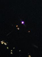
Also, any idea what the two bright stars/planets(?) are at https://youtu.be/DETb68nNZ2A?t=306
Posted by: Sean Dec 5 2021, 05:59 PM
Time-lapse cadence varies and some shots I've doubled playback because cadence offset was irregular and returned stutters.
I'll dig into the file dates for the planets shot. My guess is Moon & Venus.
Also, any idea what the two bright stars/planets(?) are at https://youtu.be/DETb68nNZ2A?t=306
Powered by Invision Power Board (http://www.invisionboard.com)
© Invision Power Services (http://www.invisionpower.com)