Printable Version of Topic
Click here to view this topic in its original format
Unmanned Spaceflight.com _ Private Missions _ HAPS-1
Posted by: djellison Aug 2 2008, 08:32 PM
Next weekend, if everything goes well, a 15x30cm carbon deck will fly onboard HAPS-1 -http://www.pegasushabproject.org.uk/wiki/doku.php/missions:haps:haps-1
One end of the deck will be the flight radio, the other is my responsibility, a single camera (Powershot A560 ), stand alone GPS logger (to 18km), and a small wide angle mirror so the camera can see the payload, the chute and the envelope above.
Still working on a hacked firmware for the A560 - but the intention is every minute will include 15s of video, and then 5-10 stills in fairly quick succession - with the hope that the rotation of the balloon will give us some mosaics out of each section.
More details, some photos etc, later in the week.
Posted by: Stu Aug 2 2008, 08:39 PM
Congratulations! That sounds very exciting, can't wait to see the pics that - hopefully - come back.
But tell me, is it true you've had to brief Downing Street on the anticipated results of this test flight..? 
Posted by: djellison Aug 2 2008, 08:51 PM
What, brief the worlds second dullest scotsman ( after Andy Murray ). I'd rather pull my own teeth 
Having issues with the expanding foam I use to insulate the camera - might take some work. We'll get there.
Doug
Posted by: djellison Aug 2 2008, 11:49 PM
Possibly - and it's only possibly - we'll have uStream from the launch site, and live tracking, if we can, during some/all/none of the flight. More details as and when I have them.
Camera and GPS have their own housing now - reasonably pleased with it - need to tidy it up a bit - but the camera is rigid inside, the gps sits on top - but the battery pack is tucked away.
I'm fairly sure that I'll go with the wide-angle lens to stick on the front of the camera - I'll regret it after the flight if I don't. I'll do back to back tests on image quality, however, to make sure it isn't screwing everything.
We'll be using the chute I bought some time ago with the intention of doing my own project...so it wasn't wasted
Doug
Posted by: djellison Aug 3 2008, 12:14 AM
Following on from the high altitude balloon thread, I thought it made sense to make a new thread for (hopefully) next weekends launch of HAPS 1 ( http://www.pegasushabproject.org.uk/wiki/doku.php/missions:haps:haps-1 )
Posted by: nprev Aug 3 2008, 12:28 AM
So, what's it like to not require sleep, anyhow? 
(Never mind...ramblings from an old dude.) Good luck & godspeed; looking forward to seeing the results!
Posted by: djellison Aug 3 2008, 12:31 AM
Just for testing, I did a walk-around with the GPS logger on 10s intervals yesterday
Should drop straight into Google Earth. It starts ratty and all over the place - but once it's had a few mins to get a proper log once we left the house, it's an accurate trace of a walk around the block - no point more than about 2m out.
It'll work till about 40kft - and then hopefully log back on again on the way down. in case of a failure of the flight computer - we can extrapolate the ascent, extrapolate the descent, and where they cross is a rough estimate of apogee
Doug
Posted by: djellison Aug 6 2008, 09:00 AM
The 'flight' SD card ( and a flight spare ) have arrived - the Sandisk Extremem III 4gb SDHC card.
From Sandisk.com
# Built to perform in the most extreme environments and temperaturesfrom
-13º F to 185º F
-25º C to 85º C
# Min 20MB/second** sequential read and write
# Durable, reliable and thoroughly testedtemperature tested (heat and cold); shock and vibration tested
OK - not the -50 we may see on flight - and sadly we wont get values for the flight min/max temp (next time maybe) - but it's the sensible option just to get the most robust card I can reasonably find.
After the joy of 200hz Phoenix EDL data - I desperately want to log Acceleration for the next flight. The motherboard doing the work on the avionics side has an accelerometer, but it's very much KISS this flight, and no data volume to save such a a large data set either - but I'm going to push to try and achieve that next time around.
Foam enclosure is finished, deck has foam underneath as a stand-off on which the 1/4 wavelength antenna will go.
Posted by: mps Aug 6 2008, 09:35 AM

The memory card can handle -25 C - that's fine, but what about the camera? A560's nominal operating temperature is only 0 to 40 deg C

Posted by: djellison Aug 6 2008, 10:16 AM
Essentially there's not a lot we can do about that... what we CAN do, we do do...
Use Lithium AA cells which dont drop off at cold temps (http://data.energizer.com/PDFs/l91.pdf - OK to -40deg - very expensive at £1 each roughly, but worth every penny)
Give the camera quite a lot of work to do (hence the 4gb card, I intend to fill it on a schedule of 3hrs) thusdumping the 9 whrs of energy from the two cells about as rapidly as possible into the camera which will render itself as heat.
Insulated as well as I can in foam (although the fact that the lens 'opens' means it's not even slightly sealed around the front)
And a 'get up and get down' flight plan to avoid lingering at altitude.
The first, third and last of those has been enough for similar flights in the past.
I feel sorry for the GPS logger on top of the foam -it's only going to have a layer of duct tape between it and the hell outside BUT - thermally speaking, the camera will be a warm glow underneath.
Doing something as simple as a pair of 9v cells dumping to a thin film heating element is just too much complexity and mass. If we mature the project to go for high altitudes or lingering, then I will be aiming to disable the camera's motor-driver lens deployment, keep it stuck out, and match foam around the lens to better insulate.
Of all the things that could go wrong - the camera getting too chilly isn't top of the list by a long long way. DOing it this way has worked for lots of other projects, so I'm happy to go that way. Next time around maybe we log temps internally on the camera, externally on the foam and then in free air under the balloon - using a Picaxe kit or similar.
It's worth mentioning though, that for perhaps 10 minutes, maybe half an hour, this whole schbang will be at 10mbars or less, at -50 degrees, with lots of UV radiation.
Remind you of anywhere 
Doug
Posted by: hendric Aug 6 2008, 06:42 PM
Doug,
What about the chemical hand-warmers used for camping/hunting? I believe those last several hours. Might not be worth the bother unless there are some definite temperature issues.
Posted by: nprev Aug 6 2008, 06:57 PM
Aren't those based on some sort of magnesium compound, or something else rather volatile? I don't know how they'd behave @ peak altitude (or if they'd work at all.)
All I'm directly familiar with is the US military's Meals-Ready-To Eat (MREs)...and those heaters get HOT really fast upon addition of water, plus they emit some fairly nasty gasses if you catch a plume; it'll bring tears to your eyes, and not just because you ended up with "spaghetti" instead of something sort of edible...
Dunno. Packaged chemical heat sources seem to peak out rather quickly & require an external trigger to activate. Sounds complex & risky to me.
Posted by: ElkGroveDan Aug 6 2008, 07:03 PM
At least there will be no perchlorates to deal with.
But seriously, I feel a bit like http://en.wikipedia.org/wiki/Rip_Van_Winklehere. Can you share with us some of the history of this version of your project? Last I heard there were too many restrictions in the UK and you dropped the entire balloon idea. Now it seems like 20 years have past and everything is different. What did I miss???
Posted by: djellison Aug 6 2008, 07:14 PM
I simply 'got a ride' with people who know what they're doing - namely James Coxon and friends ( http://www.pegasushabproject.org.uk/wiki/doku.php )
I emailed them and just went over to watch them do some cool things ( drop a parafoil type vehicle from under a balloon, then two normal launches ) - and on the two normal launches, the camera was hung under the gondola, which was under the radio payload. I commented that I'd tried to have a go myself but found it too damn complicated, and then commented that perhaps the camera payload wasn't the best way of doing it - so James basically said 'think you can do better...go on then!'. And so here we are
I promise - some pictures before it goes up - it's not pretty, but it should work
I've looked at the hand-warmer thing - but actually too hot - and they can expand as well - they're a small bag, and taking a bag to 10mbar could burst it, dumping hot chemical gooo all over the camera etc. You have to be careful to use open-cell foam or it can pop-corn all over the place. Bubble wrap can burst as well.
Posted by: ElkGroveDan Aug 6 2008, 07:27 PM
I might add that I recall someone giving me socks that were powered by AA batteries several years ago when I was a hiker. They are meant more for an emergency when your feet are getting cold in a bad way. Lemme see if I can find them online somehwere. For the next flight anyway.
EDIT: http://www.rei.com/product/703131?cm_mmc=ps_google-_-Category%20-%20Footwear-_-Footwear_Socks_General-_-electric%20socks&gclid=CIGcw8L3-ZQCFSQdagodWVVYrg
Posted by: djellison Aug 6 2008, 07:35 PM
I actually bought some AAA powered gloves - it's a thought for next-time around
Posted by: djellison Aug 7 2008, 12:20 AM
OK - no video I"m afraid. The hacked firmware for that just isn't working, and I want an all-night test running just stills. If a miracle happens and I get some CHDK help in the next 24 hrs I may change my mind on this, but it's unlikely...I'd rather be confident of good stills.
Currently - the sequence is this
8 stills ( which takes 30 secs)
Sleep 30s
repeat.
Tomorrow - I decide to use or not use the .45x wide angle adaptor, and placement, if any, of the wide angle mirror.
D
Posted by: ElkGroveDan Aug 7 2008, 12:24 AM
You need more sleep than that or you're going to look like Stu the night he was out partying with John Spencer.
Posted by: nprev Aug 7 2008, 12:56 AM
I'm tellin' ya, Dan...nobody needs to sleep in the UK, they just do fun stuff all the time! Still thinking of emigrating.
Posted by: mps Aug 7 2008, 06:54 AM
As it is flight-proven design, I have no doubts anymore
Doug, you as a PI of imaging system should set a good example for ESA and publish the images as soon as you get them - and they better be raw images, not JPEG-s

Posted by: djellison Aug 7 2008, 07:15 AM
It'll be JPG's - and they'll be going online as soon as I can get them there. If everything is nominal, then Sat night.
An overnight test with Lithium AA cells, had the script running for 5 hrs, taking 2023 images, before filling the card and stopping, and the battery is still going strong.
Doug
Posted by: djellison Aug 7 2008, 03:52 PM
Two week pushback to - Aug 23rd. Short term forecast is for high ground winds - which are not good for launching on Sat.
It means I can do more testing, possibly get a 2nd camera in there, etc etc.
Posted by: imipak Aug 7 2008, 06:57 PM
What're the chances of getting video working in the two weeks? Loved their site, BTW, especially the flight control software ("avionics"?) written in Perl. Another frontier falls to the camel!
Quite a few of the earlier flights met a watery end, presumably you wouldn't be considering risking a second camera if you thought this was likely - is it just a case of moving the launch site west, or is the "cut down box" smaller? And a silly idea which I'm sure you've considered, I'm just wondering what the catch is: how about a camera facing vertically down with a fisheye lens?
It's fascinating stuff, thanks for posting it here.
Posted by: djellison Aug 20 2008, 11:34 PM
The video now works MASSIVE Kudos to CHDK guru Dave Mitchell who sorted out an A560 firmware for me that works.
We hope to go this Sat - forecast looks quite good
Posted by: ElkGroveDan Aug 20 2008, 11:36 PM
Do you have a Twitter account set up for it?
Posted by: djellison Aug 21 2008, 12:28 AM
Yeah, it's getting a bit crazy with every single thing having a twitter acount and tweeting at other tiny things...
it's here : http://spacenear.us/tracker/
Posted by: djellison Aug 21 2008, 05:40 PM
Decision made on extra 'goodness'. I'm going to play chicken. No wide angle lens, no mirror. Just the camera, as it is, pointing straight out. Better is the enemy of good enough and all that jazz.
It's 320x240x15fps movies ( 10s ) then 5 stills, looping at about 1 minute intervals.
It's out in the garden right now running a loop with trees and sky to look at for a couple of hours, inside its housing.
On the day, we'll be launching from Churchill College on the west end of Cambridge.
Posted by: JTN Aug 21 2008, 10:37 PM
Are spectators welcome?
Posted by: djellison Aug 21 2008, 11:26 PM
I wouldn't recommend it - for a reason I can now brilliantly demonstrate....
We've pushed back to Sunday, because the bubble of still air that we were hoping to release in to has decided to take it's time arriving. A Sat predict has changed from a nice flight about 40 miles east, to about 80 miles south. The Sunday predicts are now better than the Sat predicts ever were - with a 40km E flight to about Thetford area.
Chances are - it'll get shuffled again one way or the other, and it's hard enough organising the launch team Best bet is to follow along here : spacenear.us/tracker/ : we'll twitter, hopefully uStream, probably live-track the flight.
Doug
Posted by: djellison Aug 23 2008, 07:39 PM
Right - less than 24 hrs to go
Keep an eye on http://spacenear.us/tracker/ tomorrow morning - hoping to launch at 1000-1100 UK time ( so 0900-1000 GMT )
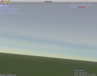
Current predict from the Wyoming uni website ( http://weather.uwyo.edu/polar/balloon_traj.html ) is to a few miles west or Norwich ( attached )
Just packing all the kit and tools we might need before getting a reasonably early night - I leave at 0700 tomorrow to get down there.

Posted by: ElkGroveDan Aug 23 2008, 11:40 PM
The Google Earth link really helps for we foreigners who aren't instinctively familiar with the local geography.
This looks like you are going to get some astounding images if everything works well.
Posted by: djellison Aug 24 2008, 05:46 AM
Right - 0640 - early start - I'm packing up the car and heading out to Cambridge. Keep an eye on http://spacenear.us/tracker/ for tweets, possibly ustream, hopefully live tracking, and an IRC channel. The 'live' images from the top are a pre-loaded jpg, but overlayed with realtime time/gps/altitude data from the payload downlinked as SSTV (couldn't get a webcam / hacked canon to work properly in time to take images for that)
I have the A560 with it's firmware ready to go ( 10s of 320 x 240 x 15fps, then 5 stills, then 30s sleep - looped ) - and a backup A550 with just a 20s looping one image script ready to put on instead if the A560 dies during launch prep ( only one will launch )
The uStreamage will probably be from me ( if it works ) on my Macbook Pro - so I'll try and show you all the things happening after launch - and even try and get the launch itself, but I'll be busy doing launch preps so no promises there.
Doug
Posted by: djellison Aug 24 2008, 08:38 AM
At Churchill - heavy rain is now dying off to a drizzle. We think we will be launching later than planned - more like 12 than 11
Posted by: djellison Aug 24 2008, 11:08 AM
Fun times with the avionics - leaving James to troubleshoot while we have some lunch.
Posted by: JTN Aug 24 2008, 04:31 PM
They launched around 14:25 BST, with GSM disabled because it was playing up. Unfortunately the packet radio has been too weak to hear, apparently. The beacon was strong last I heard, though. I think everyone's now wandering around Norfolk in cars trying to track it.
A few random pics of the launch in http://www.chiark.greenend.org.uk/~jacobn/2008/08/haps-1/. Also got a launch video which I'm figuring out how best to upload.
Posted by: JTN Aug 24 2008, 06:24 PM
Wobbly launch video now linked at the above page (or http://www.chiark.greenend.org.uk/~jacobn/2008/08/haps-1/MVI_0366_CUT_MP4.AVI), Apologies for rotation halfway through. Helen says on IRC that they're still getting signals and are hunting in a field in Diss.
Posted by: dougs_better_half Aug 24 2008, 07:06 PM
Hi all
Doug's better half Helen here. Have been keeping the IRC thread up to date with news all day as and when Doug called or texted, due to the lack of ustream and tracking data.
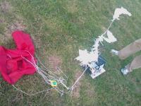
About 15 minutes ago i had a call to say they had seen the balloon. They were hunting around a lady's paddock where they had tracked the beacon to, and she was helping them look. She then spotted the red material of the parachute in a neighbour's field, and he was around and kindly let them in to reclaim the balloon.
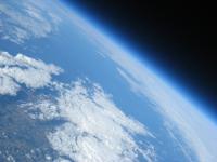
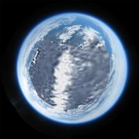
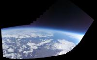
It was in one piece, good condition, and the camera worked a treat. The pictures, i have been told, are AWESOME - with black skies, bluey atmosphere, clouds and even a bit of the curve of the earth. The movies have worked too.
Doug says that pictures and videos will follow - but he won't be home here til nearly midnight GMT, so don't expect them for a few hours yet!
My congrats to the balloon team and hello to all those who followed the day on mibbit
Helen
Posted by: Paolo Amoroso Aug 24 2008, 07:30 PM
Breaking news: I have just received a http://upload.wikimedia.org/wikipedia/commons/4/4b/Stardust_Capsule_on_Ground_011506.JPG on the ground
Congratulations on an exciting and successful mission.
Paolo Amoroso
Posted by: dougs_better_half Aug 24 2008, 10:17 PM
Ack - i just realised how dreadfully euphemistic that sounds...
Anyway Doug's home now, so I'm sure pics will follow very shortly...
Posted by: ElkGroveDan Aug 24 2008, 10:26 PM
Thanks Helen. I wasn't aware of any other place to follow the events of the day, so I've been checking back here. Sounds like you'll want Doug to leave his shoes outside when he gets home. No telling what he stepped in out there.
Posted by: djellison Aug 24 2008, 10:31 PM
Launch at 1425 BST (1325Z)
Apogee at 1628 BST (1528Z)
Landing at 1712 BST (1612Z)
at 52.443499°N
1.203319°E
Amazingly, with a 10s out of every minute chance - I think we got all three events at least partially as videos.
Not sure of Apogee height yet.
Attached, one cool movie from near apogee, and one cool still during flight, and the scene at landing.
130 mile drive home. Shattered. More funky pics tomorrow - ALL the stills and vids will get uploaded over the next few days ( 3 gig ) . Not got full KML's yet - I may have KML's for the bottom 'half' of the ascent (cheap GPS craps out at 18km ) - but if I had to guess - I would say we ticked the 100,000ft box - we have SO MANY amazing image from altitude.
Kudos to James Coxon for the avionics half ( even if it didn't go to plan, it went enough to plan to get it back ), Ed and Fergus for the epic amount of experience, and Steve for his awesome Radio + Yagi signal finding technique. And Helen, our press officer and outreach coordinator Everyone played their part and it wouldn't have worked without all of them.
|
|

Posted by: djellison Aug 24 2008, 10:56 PM
My stand-alone GPS logger excelled itself. I thought it would crap-out at 18km
926 24/08/2008 15:59:59 5222.0828 52.95 19.1 23919
that's it at 23.9km - the next record
927 24/08/2008 16:33:21 5224.0947 50.7969 52.1 23942
33 mins later - back at 23.9km 16:28 was apogee in the GPS 'hole' of coverage on my logger.
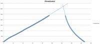
Posted by: djellison Aug 24 2008, 11:24 PM
Here's altitude against time (mins from launch) . The thick part is actual data points. The thin is rough extrapolation after it hit the GPS 'hole' for cheap GPS I'd say 32km is a fair estimate - 104,000ft
Hopefully we'll have a better figure from the GPS on the avionics board, but I'm not 100% sure.
|
Posted by: ElkGroveDan Aug 24 2008, 11:37 PM
Congratulations Doug. That is just about the coolest darn thing I've seen anyone I know do on a Sunday afternoon.
Posted by: james_coxon Aug 24 2008, 11:55 PM
Pretty good guess at the burst altitude which was 32337.4M (106093.8ft)
The full gps log can be found at http://www.pegasushabproject.org.uk/wiki/doku.php/missions:haps:haps-1:biglog
James
http://www.pegasushabproject.org.uk
Edit: Also the kml file can be found on the HAPS-1 page: http://www.pegasushabproject.org.uk/wiki/doku.php/missions:haps:haps-1
Posted by: Juramike Aug 25 2008, 12:42 AM
Outstanding! And congratulations!
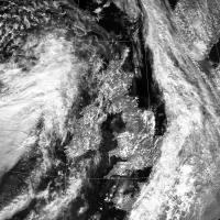
Here is an image from NEODAAS/EUMETSAT Dundee Receiving Station (http://www.sat.dundee.ac.uk/auth.html) of the NOAA-18 image of the UK taken at 1318 UTC. (Roughly 2 h before the balloons maximum height).
|
I think the first black sky image you posted might've been pointing towards the NNE (cloud shadows kinda look that way too.)
(And the fist movie you posted might be looking towards the S?)
-Mike
Posted by: ugordan Aug 25 2008, 09:16 AM
So when can we expect raw images to hit the raw pages? 
Great stuff, guys, the high altitude shot with the black sky is awesome. Can't wait to see more. Have you thought about taking the next step - say strapping a solid booster that kicks in when the baloon pops and shoves you another 10 km higher or something?
Posted by: djellison Aug 25 2008, 09:24 AM
I want to try and add lat/long/alt to the EXIF of the stills, (proper PDS headers...PAH) then upload them all. It's 850+meg of stills - so it'll take a few hours - but it will happen - and probably today.
Doug
Posted by: Paolo Amoroso Aug 25 2008, 09:35 AM
Holy bit! Folks, get yourself golden spaceflight pins, quick!
Paolo Amoroso
Posted by: AndyG Aug 25 2008, 09:46 AM
Many congratulations to all concerned!
And thanks for the new desktop background!
Andy
Posted by: climber Aug 25 2008, 10:07 AM
This is juts fantastic! Felicitations.
Can't wait for the picture taken from above by MRO. You planed it, didn't you ?
Posted by: remcook Aug 25 2008, 11:15 AM
That's pretty bloody cool  Amazing what you can do with relatively little resources.
Posted by: djellison Aug 25 2008, 11:15 AM
Right - ALL the JPG's, AVI's, as well as three MOVs (which string together all the AVI's into about 25 mins of movie ) are uploading now - it should be done by the end of the day - I'll post links when it's finished, and then I'll do some mosaics and a 'best of' with alt info etc.
D
Posted by: PDP8E Aug 25 2008, 02:20 PM
Doug and all involved,
Kudos!
I just love it when people 'just do it'!!!!
Posted by: djellison Aug 25 2008, 02:35 PM
All the raw movies
http://www.umsfbu.com/HAPS1/VIDEOS/
Probably better are these
http://www.umsfbu.com/HAPS1/EDITED/MOVIES/
Three MOV's which show all the movies strung together - and one MOV which shows every still in sequence at 6fps
The Stills are still uploading. I gave up trying to get GPS into the EXIF - I'll just do a page of the best stills and mosaics
http://www.umsfbu.com/HAPS1/PHOTOS/
Posted by: jamescanvin Aug 25 2008, 03:32 PM
Wow! The descent movie is a fantastic ride back to earth from the edge of space. Astonishing, thanks for that.
Posted by: ugordan Aug 25 2008, 04:29 PM
This is freakin' awesome. Tell me those aren't jet engines I hear from 6:46 till 6:56 in the first movie, http://www.umsfbu.com/HAPS1/EDITED/MOVIES/haps1_5822_6146_1325_1424.MOV ?
The middle movie with the solar flare and wind noise sure reminds me of Shuttle SRBs when they start falling back down.
BTW, is the camera limited to 8 bit audio only?
Posted by: Tman Aug 25 2008, 04:29 PM
Fascinating venture! Congratulations!
Yeah first you may think the ride on the balloon is intense before you've seen the ride with the parachute
Apropos, if it's desired, would it be possible to stabilize the payload with a kind of tail unit that run with the wind?
In this sequence do you hear an airplane too? http://www.umsfbu.com/HAPS1/VIDEOS/MVI_6080.AVI
A violation of the exclusion zone
Posted by: jamescanvin Aug 25 2008, 04:45 PM
OK wget is still downloading but this has to be the coolest:
http://www.umsfbu.com/HAPS1/PHOTOS/IMG_6103.JPG
Right in the middle, that's the moon!
Confirmed with Celestia.
|
Posted by: djellison Aug 25 2008, 04:52 PM
To be honest, you would probably just make it worse. It's just too chaotic and random to try and guesstimate what might or might not make it all more stable. Anything that can give the parachute something to get tangled up in, probably isn't a great idea. That's why I decided against putting a small camera out on a beam to image the payload in-situ. The best way is to make a small payload, and put it on a long long line to the balloon and let the laws of physics ( and the low frequency of the pendulum you're left with) do the rest.
MVI_6080.avi is just a sub-set from that large MOV ( the MOV's are all the AVI's in sequence ) - so it's the same thing - and at 11,000ish M ( 36kft ) - it's not beyond the realm of possibility that there's an aircraft nearby. Given that I can hear the aircraft at 15kft the way into East Midlands from the ground here - it wouldn't have to be close to hear it. That that sound is the only thing for, well, 11km in any direction - and without a lot of doppler shift it's not passing that close by.
The audio is infact only 11khz 8bit mono off the camera - that's all it's got I"m afraid. It was a £70 camera, I didn't fancy risking anything more expensive than that.
Yeah - we spotted that last night looking at them from the boot of our car....I thought I'd see how carefully people were looking
Posted by: ElkGroveDan Aug 25 2008, 04:55 PM
Curious about those first couple of blurred stills. Was there an autofocus feature activated?
Posted by: Stu Aug 25 2008, 04:57 PM
SERIOUSLY impressive stuff, congratulations to everyone involved. Technically superb, and also just a v v cool thing to do!
Posted by: djellison Aug 25 2008, 04:57 PM
The JPG's have finished uploading - so it's all there - enjoy
The first few stills are blurry just because it's REALLY moving around, 180deg/sec in some cases - look at the second .avi to see what I mean.
MVI_6494.AVI is at apogee and you can see pieces of the ballon just after it has burst ( and the resulting chaos that freefall at 106,000 ft and 11mbar )
From 1520Z to 1530Z, the payload was over 30km - which is images IMG_6447 to IMG_6501 ( or MVI's in the same range )
Posted by: jamescanvin Aug 25 2008, 05:08 PM
Now I've looked through them all I see there are even cooler black sky + curved horizon + moon setting shots.
e.g.
http://www.umsfbu.com/HAPS1/PHOTOS/IMG_6313.JPG
Posted by: djellison Aug 25 2008, 05:15 PM
When you download the images, can you still find the 'image taken' time on them? If so - you can X-ref that back to the BIG LOG. (The EXIF image data has that)
http://www.pegasushabproject.org.uk/wiki/doku.php/missions:haps:haps-1:biglog
i.e. 6313 was taken at 145502 - which means an altitude of 22482.7M - only 2/3rds the way 'up'
Doug
Posted by: djellison Aug 25 2008, 05:20 PM
LOL - love this page - http://www.eoss.org/handbook/chap3.htm
"If you stacked pop cans 100,000 ft high, it would take about 259,500 pop cans (each pop can is 4 -5/8 inches high when you subtract out the part of the can that fits inside the can below it). That's about 10,800 cases of pop."
Posted by: djellison Aug 25 2008, 05:24 PM
This image - http://rapidfire.sci.gsfc.nasa.gov/realtime/single.php?2008237/crefl2_143.A2008237132001-2008237132500.4km.jpg at 1320Z is 5 mins before launch. It's distorted - but the near realtime subset image for Aqua will use that same image, properly projected..
So these two (the Aqua ones, not Terra - that's 2hrs earlier) cover the view over the UK, and to the east, at, roughly, flight time
http://rapidfire.sci.gsfc.nasa.gov/subsets/?subset=Europe_2_01.2008237
http://rapidfire.sci.gsfc.nasa.gov/subsets/?subset=Europe_2_02.2008237
Posted by: ugordan Aug 25 2008, 05:26 PM
http://www.umsfbu.com/HAPS1/PHOTOS/IMG_6504.JPG
"My God, it's full of stars!"
Posted by: jamescanvin Aug 25 2008, 05:29 PM
Yes I've still got all the 'modified times' preserved as the time each was taken. The latest and hence highest moon shot I can spot is this:
http://www.umsfbu.com/HAPS1/PHOTOS/IMG_6435.JPG
Very close to setting at 16:17BST - ~29,000m (95,000ft)
Posted by: djellison Aug 25 2008, 05:54 PM
Here's the combined view using google earth, and the KMZ's that the MODIS guys produce.
|
Posted by: jamescanvin Aug 25 2008, 06:34 PM
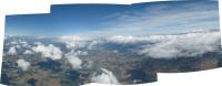
A quick pan:
http://www.nivnac.co.uk/files/HAPS/6417_19_35_80_81_v2_full.jpg
Click image for full size version - (9016 x 2686) 1.7Mb
Around 180 degrees, looking east out over the North Sea. North is somewhere on the left. At the bottom of the second image from the left you can just see the curve of the coast of East Anglia. Under the cloud on the right should be Northern Europe. The moon is in there to, just left of centre. Taken at between 28,000 - 31,000m (92,000 - 101,000ft)
James
Posted by: ElkGroveDan Aug 25 2008, 06:37 PM
Just when I thought it couldn't get any better, the image wizards step in.
Now if someone would trace in the coastlines, that would be a real treat.
Posted by: Paolo Amoroso Aug 25 2008, 06:45 PM
http://www.umsfbu.com/HAPS1/PHOTOS/IMG_6103.JPG
Right in the middle, that's the moon!
Doug, you should definitely submit this to http://lpod.wikispaces.com/.
Paolo Amoroso
Posted by: ugordan Aug 25 2008, 06:47 PM
Now that is just sick!!!
Posted by: djellison Aug 25 2008, 07:39 PM
Probably wrong, but roughly indicative, and certainly badly photoshopped....
|
Posted by: jamescanvin Aug 25 2008, 07:48 PM
About the same as what I reckon. That'll be Denmark on the horizon, and on the far right not shown on Doug's overlay should be The Netherlands. Pretty much the whole North Sea there.
I matched up the bit of East Anglia in that shot, it's the very northern tip.

|
Pink lines show the ballon trajectory in the forground.
The earth really does look like Google says it does; only bluer!
Posted by: djellison Aug 25 2008, 07:52 PM
I knew that if and when this worked, I would see you guys come up with every mosaic and analysis an interpretation - far quicker and far better than I could. I just tried to get the best data I could to feed the machine
I now understand, perhaps a bit more than most, how and why Steve and Jim and Alfred and Pete do what they do. I now also can not understand, more than ever, why Europe does the opposite. But I can tell you I know EXACTLY why the ESOC guys have turned that VMC back on.
Posted by: djellison Aug 25 2008, 07:54 PM
For our foreign friends, it's probably worth mentioning that The Wash ( that U shaped bay ) would appear to change a lot from altitude, as it's almost all very very shallow and produces large sand-banks at low tides. It's the venue for the story of King John's Treasure ( probably false ).
Doug
Posted by: ElkGroveDan Aug 25 2008, 08:40 PM
Ah I know a bit about The Wash and St. John's Treasure and The Fens from Louis L'amour's Sackett series. There's nothing more entertaining than historical fiction.
Posted by: imipak Aug 25 2008, 09:17 PM
Fantastic stuff; the video is just hypnotic. I also wondered about some sort of weather vane to at least slow the speed of the oscillations (though no oscillation = no pan) but the risk of tangling the chute would be non-zero. Would that be the purpose of the boxkite-like affair ISTR seeing in photos of met balloons?
That dark sky and curved horizon is so, so tantalising... hmmm a quick Google turned up http://www.nsschapters.org/al/HAL5/HAL5_old/HALO/SL-1/SL_1c_post.txt of a 100000' rockoon launch reaching "30-36 miles apogee", and the HAL5 HALO project which seems to have gone quiet in recent years(?)
Posted by: jamescanvin Aug 25 2008, 09:29 PM
Now THIS is what I always wanted from the UMSFB/HAPS-1 project - 360 degree panorama!
http://www.nivnac.co.uk/blog1.php/2008/08/25/haps-1-360-degree-panorama
http://www.nivnac.co.uk/blog1.php/2008/08/25/haps-1-360-degree-panorama
Click image to go to my (never before used) blog with various sized download options.
I'll have a look for more images to try and fill in the foreground tomorrow.
Enjoy,
James
Posted by: ugordan Aug 25 2008, 09:44 PM
Oh my... this is seriously becoming APOD material 
The next balloon better have gyros for attitude and pointing determination so panorama stitching can be automatized.
Posted by: djellison Aug 25 2008, 09:58 PM
Get the **** out of here. That is INSANE.
QTVR of it attached:
Posted by: Juramike Aug 25 2008, 10:48 PM
Doug's next objective?
|
Posted by: Astro0 Aug 26 2008, 12:39 AM
Along the same lines as above. Congratulations to Doug and the HAPS-1 team.

|
Astro0
Posted by: jekbradbury Aug 26 2008, 02:58 AM
Here's a Photosynth of the first 70 photos (only 20% Synthy, it can't match up about half of the images) that is pretty cool once you get used to the viewer interface. It matches and stitches the images, but Photosynth unfortunately can't output a panorama or mosaic.
http://photosynth.net/view.aspx?cid=EB8C5E81-18FA-4B4C-80EF-5745BC7CA2C7
Posted by: Juramike Aug 26 2008, 03:15 AM
Added a spherically distorted and otherways modified version of the http://www.unmannedspaceflight.com/index.php?s=&showtopic=5369&view=findpost&p=124340 to the blank spot to try and fill in the gap:
|
Blink GIF showing the modified NOAA-18 image then overlain by James Canvin's mosaic:
|
(The white line in the modified NOAA18 image defines the "pig's bottom" part of East Anglia):
-Mike
Posted by: eoincampbell Aug 26 2008, 04:33 AM
Hello to the forum and congratulations...
May I ask about the complications involved to "clear" this flight ?
Is the BAA not "down with this sort of thing"...
I'm quite "undulled" as a Scotsman myself...
cheers All,
Eoin
Posted by: Juramike Aug 26 2008, 05:02 AM
I played with some images around the horizon, lining them up and looking at the horizon to black sky transition around the mosaic:
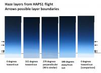
|
I think you can see some forward scattering (brighter towards sun) haze layer boundaries (indicated by black arrows). There also appears to be a definite brighter haze or upper cloud layer seen at 315 and at 45 (not shown). 'Course this is also towards the London megalopolis.
[There appears to be a darker layer towards the sun also, so I don't think these are image artifacts.]
-Mike
Posted by: mchan Aug 26 2008, 09:59 AM
I think I am starting to get SAS after watching the videos a few times. 
And it was still less than 1/3 of the way up to space.
Congrats on the successful mission.
Posted by: djellison Aug 26 2008, 11:06 AM
I'd be interested to see what people would change in terms of pointing, orientation, and image sequencing with just the one camera for future flights - and if they could have a second camera, what they'd do with it.
Doug
Posted by: ugordan Aug 26 2008, 11:33 AM
Well, one suggestion that comes to mind when looking at the images would be to have one camera as is or even tilt it downward ever so slightly, while the other pointing near-nadir, say at a 90 deg angle to the first one. The panorama is, after all, missing the central portion.
Since the second cam would be looking almost straight down pretty much all the time, there'd be no need to capture as many images that just end up being rotated. Maybe longer movies instead?
Posted by: jamescanvin Aug 26 2008, 11:57 AM
Well this goes back to http://www.unmannedspaceflight.com/index.php?s=&showtopic=4635&view=findpost&p=101212. With one camera I think as is was about perfect. If I got to add a second camera then for sure it needs to point downish. Thinking back to my sims, I would suggest having it in 'portrait' orientation with the lower edge close but not quite nadir (centre of image about -50 degrees elevation (FOV is ~53 degrees, so this would capture ~-24 to -76 degrees elevation in level flight)
Maybe it's time to break out that sim code again now we have more data on how the balloon really behaves.
Posted by: JTN Aug 26 2008, 12:14 PM
Is the BAA not "down with this sort of thing"...
I don't know about this specific flight -- maybe Doug or James Coxon can say -- but on the Pegasus wiki for a previous flight there's http://www.pegasushabproject.org.uk/wiki/doku.php/missions:pegasus1#permission of the permission/notice procedure.
Posted by: Juramike Aug 26 2008, 12:20 PM
It seemed that when the limb was thinner (more black sky, soooo cool) the exposure setting function would blow out the horizon.
If there was any way possible with hardware or software to dampen down the exposure changes....
-Mike
Posted by: djellison Aug 26 2008, 12:39 PM
Without risking under-exposing the other images - no. We could bracket-expose images, but that trebles the data volume and probably wouldn't get the range anyway. It's just one of those things. Take enough shots such that yeah, you'll get loads of over exposed dark images, but you still get enough good ones.
Doug
Posted by: Ant103 Aug 26 2008, 12:53 PM
Wow
It's an amazing work. Really impress by pictures taken during the ascending of HAPS-1.
Doug and other, you made a GREAT work  .
.
Love the last part of the second edited movie, when the wind dicrease, it's a moment of serenity .
Posted by: ElkGroveDan Aug 26 2008, 01:54 PM
Can't think of much else I would do different. All things considered this was a most amazing first-time effort. Darn near perfect when you consider the goals outlined in that earlier balloon discussion.
Perhaps some additional instrumentation would add to the experience next time, like a rudimentary accelerometer. Maybe some kind of radiation or cosmic-ray detecting device.
Posted by: Tman Aug 26 2008, 02:17 PM
What wind speed hit still the payload box in the flight with the balloon? It isn't nearly zero, is it?
If you get still enough wind on the box, I would start/search some tests on the compact form of the box in order to get the rotation under better control. Maybe it could be even possible to control a desired speed and direction of the rotation during some time of the flight.
How about a compact rugby-ball-like form, maybe such deformed that you get a desired rotation? In this context it would be also relevant how the payload box is connected to the balloon/parachute cord - fixed or turnable.
Posted by: djellison Aug 26 2008, 02:35 PM
Anything from 0 kph to more than 100, and it can change very quickly as we rise thru different layers. Sunday there was almost no jet-stream - but sometimes it can be >100kph - and you could go from 0-100 in a mintue or two.
WE go up at about 10-15kph, BUT, anything you put on the payload to use that 15kph to rotate ( like the fins on Huygens) is going to influence the payload via the cross-winds far far more than the wind of ascent.
Doug
Posted by: AndyG Aug 26 2008, 02:51 PM
Doug, having just looked through the videos again:
The images are lovely - though I'm trying to work out whether the drop in pitch of the on-board mic with altitude is a function of air pressure or cold or both.
A more stable instrument platform would seem to be the next step. As you say, a longer tether would lower the frequency. It would also help by moving the package out of the worst of the turbulence "behind" what is an unstreamlined object moving at a fast jog (16 kmph) straight up.
Since vanes to supress horizontal rotation can't work (surely the balloon is moving virtually at any surrounding horizontal airspeed?) and would be a disadvantage under pedulum swing (they'd feathervane the package on each swing), why not try increasing the rotational inertia of the package?
If you went for a pair of long booms with a mass at the ends, it'd be more stable - though still free to move, allowing for panoramic views. Better, if you had three booms, you could go for a long tripod-like tether which would hang the package with a virtually assured horizon. Mass increases could be minimal - and you could boom-mount a camera with no negative effects.
Placing the parachute below the balloon but above a bridle for this sort of tether would surely not increase the risk of tangle? (In the video we get a quick shot of near zero g when the package starts falling with balloon material around it, until the parachute fills.)
Incidentally, tell me the parachute falling juicily into frame in the last video is a fix?! Too lucky by half!!!
Andy
Posted by: djellison Aug 26 2008, 03:07 PM
We didn't arrive for another 2 1/2 hours.
I think people are missing a point here. The payload is stable to the point of images being, on the whole, not blurred ( which is down, mainly, to a single payload 'deck', and a very long balloon-to-payload line ). Beyond that, you don't want a stable payload, because otherwise you would have a thousand images of the same direction. You don't want that. You want it moving around a bit to fill in the panoramas - and to be honest, all the ideas we could possibly come up with add things for lines to get wrapped around at launch, flight, and burst ( bad ) and mass ( very very bad ).
Look at the movies just before the burst. They're astonishingly stable, and have a nice gentle rotation. I think the trick I've missed is not doing enough stills sequentially. I think next time I'll do an imaging minute, then a movie minute ( so 20xstills, then a gap, then a 15s movie, then 45sec, repeat) . What we need is an imaging strategy based on the sort of dynamics we see with this flight - to get better mosaics out of it.
Incidentally, no one has started making mosaics from the movie frames yet...
It sort of works, but will take some work.Doug
Posted by: Ant103 Aug 26 2008, 03:20 PM
And what about a small camera with wide angle, like a fisheye view, at the bottom of payload, looking at the ground (a sort of MARDI-like instrument) ? It will complete the imagery setting with the first camera.
Tell me if it's a bad idea 
Posted by: djellison Aug 26 2008, 03:36 PM
That is something I'd like to do, and I think I can for about 50g - getting a fish-eye lens to do it, though, is quite hard. A Vistaquest 1005 would do the job ( google Catcam ) - but a wide angle lens is hard to find that small - infact, I'd like two - one up, and one down
Doug
Posted by: jekbradbury Aug 26 2008, 03:47 PM
A lower-mid-altitude (EDIT: ~3000m to ~3200m) horizon pan:
|
Posted by: djellison Aug 26 2008, 03:55 PM
Given the fact that you could almost walk from Cambridge to Norwich without being more than 20ft from an RAF base at any time, I was about to say 'Wow - a bit of Norfolk without an RAF base' - but actually, there is one hiding in there. Great work - why on earth would anyone ever hold back with their pictures and not let people do this sort of thing.
Posted by: jekbradbury Aug 26 2008, 04:19 PM
What is the reason for the 30 second sleep in every minute of camera operation? Is it heat, space on SD card, or something else?
Posted by: Juramike Aug 26 2008, 04:39 PM
The potential for getting regional haze layer information totally fascinates me:
How about using two cameras as suggested (one pointed towards the horizon, one looking sorta downwards) but with polarizing filters over the lenses. The two (relatively cheap) polarizing filters could be offset by 90 degrees.
You'll probably get enough swing that you get overlapping images of the horizon with both cameras. Presto, you get two different polarization modes.
-Mike
Posted by: ugordan Aug 26 2008, 05:05 PM
You'd still need calibration capability of the data as two different, cheap-o cameras will behave quite differently even in identical conditions. Remember we're not dealing with scientific instruments here!
Posted by: djellison Aug 26 2008, 05:48 PM
Bingo. I wanted a 50% buffer on capacity. From when I turned it on, to landing, used just over half the card. I wasn't 100% sure what the average image size would be at altitude ( taking a photo of a photo from altitude doesn't work as a test
) and there's a HUGE question mark over flight time (2hrs 50 we got - could have been an hour longer, or an hour less without too much being different)So - I was cautious, but as a result, we got the entire flight fairly well documented instead of most of it very well documented or some of it brilliantly documented
Doug
Posted by: ngunn Aug 26 2008, 06:15 PM
This whole thing has been an astonishing and beautiful sucess - enormous congratulations to everyone involved. You may recall I was interested way back in 3D image possibilities from this project. With so many images obtained from many different heights and no doubt some relative movement horizontally too I wonder if anyone has tried cloud 3D (viewed with the horizon vertical-ish?)
Posted by: hendric Aug 26 2008, 06:53 PM
Doug,
Does your camera have a UV filter? That might help a bit with being able to see farther through the haze.
If you do have a downwards-viewing camera, may I suggest a wind tell-tale a la Phoenix? It will not mean much scientifically, but would be cool to watch. Maybe a short stick pointing downwards with a shorter section of ribbon? (There's a sponsorship idea, buy an "inch" of ribbon and the team will write your name on it!)
Other than that, it looks perfect to me! Wouldn't it be great if every weather balloon had an imaging package?
Posted by: ugordan Aug 26 2008, 07:04 PM
I tried, but it's mainly a no-go because of cloud evolution and various lateral motions. This for example doesn't look at all impressive:
|
It's probably only good for giving one a headache.
Posted by: ngunn Aug 26 2008, 07:38 PM
Ha! Very interesting all the same to see that attempt. Those clouds are of course a particularly fast-evolving type of cloud. It might work better with some of the higher ones. Maybe a much higher view looking down through the various layers? Of course it would be easy enough to shoot nice simultaneous pairs of terrestrial clouds from the ground, but I'm thinking of the implications for balloon probes at Titan or Venus. How effectively can evolving cloud forms be studied using images from a single, moving platform within the atmosphere? I think what you've done there does at least begin to address that question. Maybe this is another consideration to factor into the imaging strategy for follow-ups.
Posted by: ElkGroveDan Aug 26 2008, 07:41 PM
Clearly, we need a camera on each end of a twenty foot pole. I guess that will have to wait for the larger payload that will be necessary for the IMAX version.
Posted by: ngunn Aug 26 2008, 07:49 PM
That's more or less what I suggested to Doug when the project was first mooted - either that or two balloons somehow tethered together, or even independent but launched simultaneously a short distance apart. All such options were understandably ruled out for the Mark I, but I still have hopes . .
Posted by: jamescanvin Aug 26 2008, 07:52 PM
OK folks, after the balloon burst and HAPS-1 was plummeting back to Earth it did manage to grab a few shots pointed more towards the ground. Here is what I'm been able to piece together. Hardest jigsaw ever!
http://www.nivnac.co.uk/blog1.php/2008/08/26/haps-1-360-degree-panorama-2nd-version
http://www.nivnac.co.uk/blog1.php/2008/08/26/haps-1-360-degree-panorama-2nd-version
It's a bit dodgy, many of the images were quite badly blurred from the rapid motion of the falling gondola and the point of view changes quickly as it falls. So it was a challenge to match many of them up. But it is still so far in advance of what I thought possible from this flight I'm over the moon about it really.
Congrats to all involved, I'm very proud to have been able to help out in my own little way on this amazing project.
Cheers,
James
Posted by: djellison Aug 26 2008, 07:53 PM
Believe me - watch the utter chaos that is involved in one launch....and you wouldn't think of saying 'can we do two?' - and to be honest, I can't imagine the statistical chance of two independent balloons pointing in independent directions on independent trajectories framing something from a stereo baseline is very high. As for two balloons - you would never be able to fill them the same, thus one would overtake the other and you would just have two cameras, one above the other - and the strops would rub on the lower balloon causing it to fail quite quickly.
Good work James....now do all the movies - like this
|
|
|
|
|
Posted by: ElkGroveDan Aug 26 2008, 08:12 PM
I look at the view from these altitudes and imagine how insane it was that Michel Fournier was going to skydive from a similar height (http://blogs.usatoday.com/ondeadline/2008/05/chute-frenchman.html)
Posted by: djellison Aug 26 2008, 08:14 PM
I'd make some sarcastic comment about how amateurish that must be.....but James and Ed are both registered at UMSF. Not that I'm saying I thought I missed a launch a few months ago as a balloon headed up shortly before I arrived only to find that they were still getting ready.
Doug
Posted by: Edward Moore Aug 26 2008, 08:20 PM
Hi all, first post. I'm the name-checked Ed of Doug's earlier post. I'm really amazed at what you guys have done with all the raw data, we'll certainly release every scrap of stuff we get next time! We've been at this balloon game a while now but I've never seen such good photography. Really inspiring stuff.
We were talking to Doug about using our flight computer on the next flight (it's not let us down since we designed it) and that will have 3 axes each of accel and gyro data logged at whatever frequency we have room for on the SD card. Having seen the signature double 'thwack' of the disc-gap-band opening on the Phoenix accelerometer data, I'll be intrigued to see if any of you guys can deduce the type of chute we'll be using for our next flight. It'll be deployed at 1km ASL to minimise the drift on the way down, so there should be a pretty decent deployment signature from the 1G under drogue. It should also be stable, so come down straight rather than corkscrew - a behavior you can see from simple flat chutes (MVI_6506 of the videos demos this nicely). Interestingly, nasa found similar behavior when performing high altitude tests of Ringsail parachutes - they don't established a stable glide/equilibrium like they do at lower altitudes, and just corkscrew around instead.
If any of you can make it to Cambridge for the next flight, you really should. We had left over sausage rolls, scotch eggs, and humous.
Some people asked about relative wind speed between payload and air. It's basically 0 as the balloon just gets whisked along with the wind. Sheer on the way up tends to cause most of the buffeting. Active yaw control is something we looked at, but unless we really really need to start flying fly wheels and motors, we won't. East Anglia's green houses wouldn't appreciate it. We'll try some passive radial ears to see if that damps some of the swinging down.
This stuff is good fun. Earth runs out pretty quickly, it's surprising.
Ed
cuspaceflight.co.uk
Posted by: Paolo Amoroso Aug 26 2008, 08:21 PM
http://en.wikipedia.org/wiki/Lawn_Chair_Larry was insane.
Paolo Amoroso
Posted by: Edward Moore Aug 26 2008, 08:23 PM
It had a hole in it! We had to let it go. They don't burst, surprisingly. But I did enjoy your hand-brake turn onto the field.
Posted by: djellison Aug 26 2008, 08:49 PM
I was so disappointed to learn that. I wanted some sort of drum-bursting shock-wave.
Posted by: djellison Aug 26 2008, 09:29 PM
These work so well!!!! Screw stills - just do HD movies like this and you're sorted

|

|
|
|
Posted by: ngunn Aug 26 2008, 09:56 PM
I'm lost for words. I hope this story makes the news beyond this forum. James, Doug, what magical images! I'd really like to read the roll call of all who contributed to this and know how the project came to fruition (in not too technical language).
Posted by: djellison Aug 26 2008, 10:04 PM
Tell you what Nigel, there might be enough movie-generated 360's to get sideways stereo (as if you head was at 90 degrees).
I've not aligned these movie-pans to be the same orientation as one another - but a quick tweak would sort that out.
Doug
Posted by: ngunn Aug 26 2008, 10:47 PM
I'm watching this space. You've got a gold mine of images there to be sure.
Posted by: elakdawalla Aug 26 2008, 11:30 PM
I'm a bit late to the party, but: waaaaaay coooooool.
--Emily
Posted by: JTN Aug 27 2008, 12:05 AM
In the http://www.pegasushabproject.org.uk/wiki/doku.php/missions:haps:haps-1:biglog, what's the significance of the odd log entry around the time of apogee? Did the balloon burst somehow upset the GPS or computer for a second?
1,152911.00,52.397731,0.850583,32337.4M,16.077,128.51
1,152912.00,52.397714,0.850598,32335.8M,11.045,146.44
1,152913.00,52.397745,0.850648,32333.8M,19.586,25.67
1,152914.00,0.000000,0.000000,,,
1,152915.00,52.397894,0.850643,32174.8M,5.268,1.29
1,152916.00,52.397921,0.850625,32131.0M,6.011,4.01
Posted by: JTN Aug 27 2008, 01:05 AM
And yet there's still http://science.nasa.gov/headlines/y2008/25aug_nlc.htm way above even here. (very unscientific illustration!)

|
Posted by: nprev Aug 27 2008, 01:20 AM
Belated congrats, Doug & team....WAY cool, incredible! You guys touched space, never mind piddly definitions...
Posted by: Pertinax Aug 27 2008, 02:49 PM
Wow Doug! Simply Wow.
Congratulations to you and to your team a dozenfold.
I got to thinking (well, googling) about the downward (and upward?) looking fisheye question and encountered: http://aggregate.org/DIT/peepfish/ . I though it worth passing along if you had not already seen it. Also, along that line of thinking there is this: http://www.doorscopes.com/hiw.htm .
I would suspect that both of these would bring with them a rather significant if not prohibitive, mass hit. None the less, I hope it is at least in some ways useful.
-- Pertinax
(BTW, are you dumping the videos to stills and then creating your panos from those, or do you have software that directly creates panos from panned videos?)
Posted by: djellison Aug 27 2008, 03:00 PM
Yup - exporting at 5fps (or the full 15 for the really fast moving after burst )
Posted by: jekbradbury Aug 27 2008, 03:29 PM
For those who wish to dump those stills and join in the fun, either Quicktime Pro or http://www.dvdvideosoft.com/guides/dvd/make-video-snapshots.htm will do the trick.
Posted by: jamescanvin Aug 27 2008, 05:44 PM
Here is an attempt to fill in the missing bits using stills from the video.
http://www.nivnac.co.uk/blog1.php/2008/08/27/haps-1-360-degree-panorama-using-video-s
Posted by: ElkGroveDan Aug 27 2008, 06:07 PM
Someone needs to name an asteroid or a comet after James.
Posted by: imipak Aug 27 2008, 09:00 PM
Seconded, 'cos http://maps.google.co.uk/maps?f=q&hl=en&geocode=&q=Canvey+Island&ie=UTF8&ll=51.523057,0.592232&spn=0.151026,0.350189&t=h&z=12&iwloc=addr !
Really amazing,.. but I have a bad case of altitude sickness (I want MORE!! ) Oh dear, fantasy ballooning... I'm daydreaming about a stabilisation vane for the ascent taking the form a tube-launched rocket (or rather, fins at one end of it) with the imaging payload at one end? At 10mb there wouldn't be much need for a strong (heavy) aerodynamic fairing, so long as the payload and decent chute could take the G. Horizontal launch with a simple mechanical system to steer the rocket vertically upwards after a near-horizontal launch... I've got such a system in mind, but luckily there's insufficient space in this margin to describe it. Hmmm, rocket mass... multiple balloons... lifting capacity... *hits google with a naive hope that it won't instantly prove to be a non-starter*
(Edit:grammar fix)
Posted by: djellison Aug 27 2008, 10:36 PM
Technically, Canvey Island is visible in the images, I think. Foulness Island almost certainly is.
Posted by: Edward Moore Aug 28 2008, 07:28 AM
) Oh dear, fantasy ballooning... I'm daydreaming about a stabilisation vane for the ascent taking the form a tube-launched rocket (or rather, fins at one end of it) with the imaging payload at one end? I'm thinking that at 10mb there wouldn't be much need for a strong (heavy) aerodynamic fairing, so long as the payload and decent chute could take the G. Horizontal launch with a simple mechanical system to steer the rocket vertically upwards after a near-horizontal launch... I've got such a system in mind, but luckily there's insufficient space in this margin to describe it. Hmmm, rocket mass... multiple balloons... lifting capacity... *hits google with a naive hope that it won't instantly prove to be a non-starter*http://www.cuspaceflight.co.uk/martlet
We're having a go!
Posted by: Paolo Amoroso Aug 28 2008, 11:39 AM
Consider one of the photos near apogee that show mostly black sky, such as http://www.unmannedspaceflight.com/index.php?s=&showtopic=5369&view=findpost&p=124386. If Doug takes a dark frame on the ground with the same equipment and the same camera settings, possibly cooling it a bit to have comparable thermal noise levels, it might be possible to compare noise densities or patterns in the images and check for any radiation effects. Can similar comparisons be done with electronic noise in the videos soundtracks?
Paolo Amoroso
Posted by: Del Palmer Aug 28 2008, 12:00 PM
No need to cool the camera, as cosmic ray hits are very obvious -- they leave bright pixels or trails on the image, given a long-enough exposure.
Powered by Invision Power Board (http://www.invisionboard.com)
© Invision Power Services (http://www.invisionpower.com)