Printable Version of Topic
Click here to view this topic in its original format
Unmanned Spaceflight.com _ Private Missions _ Nova 8 / HAPS-D
Posted by: djellison Aug 28 2008, 11:36 AM
"We're launching tomorrow morning' says Ed.
"Shame I can't make it, I have to be at work" says I.
"At 3 am" says Ed
"Hmmm" says I
Long story short - hopefully a reflight of the HAPS1 A560 tomorrow - at dawn - with recovery in time for me to get back to Leicester in time for work. Ed will fill you in on the rest of the payload. He's an engineer - I'm just a temperamental artist.
Obviously - anyone with half a brain will be fast asleep, so may not be any/many live updates. Possibly live tracking, maybe uStream while we're setting up.
The real problem is the toxicology involved in staying up all night with caffeine based beverages.
(For people just finding this thread...
Movies from the Nova 8 camera
http://vimeo.com/1628664 Ascent Part 1
http://vimeo.com/1628493 Ascent Part 2
http://vimeo.com/1628497 Ascent Part 3
http://vimeo.com/1628414 Descent
Movies from the HAPS-D camera
http://vimeo.com/1628947 Ascent Part 1
http://vimeo.com/1628809 Ascent Part 2
http://vimeo.com/1628810 Ascent Part 3
http://vimeo.com/1626812 Descent
http://vimeo.com/1628991 All of the still images at 6fps from the HAPS-D camera
http://vimeo.com/1629086 All of the still images at 6fps from the Nova 8 camera
Download the MOV from bottom right on these - and you can essentially scrub your way thru all the images at quite a reasonable resolution.
Posted by: Tman Aug 28 2008, 11:46 AM
Ohh sunrise images - very cool!
Posted by: jamescanvin Aug 28 2008, 11:55 AM
The thought had crossed my mind about how cool dawn images would be. Great to see an attempt going ahead. 
Posted by: climber Aug 28 2008, 12:36 PM
Just think you're working on a 24hxx minutes day-sol (or whatever) and you'll be fine
Posted by: Edward Moore Aug 28 2008, 12:49 PM
A few details -
The payload is based around a big polystyrene (styrofoam) box, with various layers of space blanket to keep everything inside warm(ish). The payload has been built in the last couple of days built by everyone except me - I have a summer job (ExoMars EDLS with Vorticity Systems - I'm so glad I picked engineering as a career!) whereas the other guys have managed to stay in Cambridge over the summer to work on stuff fulltime.
We'll be flying 4 cameras in total - 2 'premiers' (£5 ebay specials) which we've used since the beginning because they're dirt cheap, but a bit rubbish. However cheapness > quality after we enthusiastically bought expensive cameras once (to return to Jessops after the flight) only to have a pyrotechnic cutdown fail, and so they went somewhere into the North Sea. The Premiers will be on 'sponsor' duties - http://spacefellowship.com/News/?p=6152
We then have the HAPS A560 and our own one. These won't have sponsor logos in the way. Our one will be horizontally mounted and will have a UV filter, Doug is (I think?) mounting his in portrait with a 10 degree downward slope - as he and James Canvin discussed to optimise stitching.
The avionics comes from the 'Badger Board' that Fergus and I designed - http://flickr.com/photos/25036435@N00/2501001643/in/photostream/ and http://flickr.com/photos/25036435@N00/2501001535/in/photostream/
It's an ARM-based microcontroller, with gps, gsm, radio, some sensors (including 3 axis accelerometer, though I can't guarantee we'll have that for tomorrow, but if we do, we'll of course put the data files up), general io to activate cameras and pyro-links and so on.
The all-up weight of the payload will be about 1kg. It'll be hoisted by a 1.5 kg balloon - the balloons are named according to the weight of the latex they're made from. It's a larger balloon than was used on HAPS-1, so it might get a little higher. Our altitude record is 33.281km for reference (not that the gps is good enough for 1m accuracy in altitude). Parachute will be whatever is lying around. I'm about to start construction of a ring-slot parachute, but it's going to be a bit of a pig to make with just mum's sewing machine, and it's sized for the new payload system we're building, so we will probably still have the cork-screwing on the way down that we saw with HAPS-1.
Based on the GFS forecast, we're looking at a flight profile that is roughly like this (open in Google earth): http://www.cuspaceflight.co.uk/nova8_prediction.kml Though that assumes a higher drag descent than will be the case, so the drift during descent should be lower. Note - constant ascent rate. Once we punch through the jetstream we pretty much go straight up.
With luck, you will be able to track it live from here - http://spacenear.us/tracker You'll see there a twitter box for random updates from us in the run-up, and an embedded irc applet. It points to #highaltitude99 on FreeNode (if you prefer your own client), and it will have a bot in it which prints the raw telemetry string every 10 seconds. That just gives the basics - lat long alt, time since last reset, number of gps sats etc. That's what we use to track it down. the room #highaltitude is the main room for general ballooney chit-chat. If you want to have a go at this yourself, that's the place! There's also a uStream live webcam which Doug will sort out I think - it'll probably just be us preparing in the college Bar. If we're in wireless range outside, we'll try and get launch too, though it'll be dark.
The radio is 10mW 434Mhz. 'Why only 1/3rd the power of an LED?', you ask. Well, we are legally limited to that by Ofcom. They are a bit jumpy. That said, we have tracked stuff well out to the North Sea (that fatefull second mission) and it was several hundred kilometres away when we gave up listening and went to the pub. It was still receiving absolutely fine. So, it you're in the UK or Holland/Calais/anywhere around there and are of an amateur radio persuasion, you can listen in. Here are the details: 434.650Mhz, 50 baud, 425 Hz shift reversed ascii-7 RTTY. Callsign 'Badger' if I remember correctly. We can pick it up with a whip from at least 200km away, and if you have a yagi, the only limit will be Line of Site.
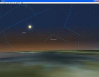
I think that's all the basics. Let's hope we get some pics of the sun creeping over the curvature of the earth!
Ed
EDIT: Forgot to say, the actual launch time will be calculated so that it first sees the sun at about 25km (sunrise is earlier up there than on the ground for a given lat/long, obviously).
Posted by: djellison Aug 28 2008, 12:56 PM

Sshhh - I was going to just put a bit of black card over the camera for 20 minutes, then come back and say "Did you see it go? It was amazing!"
Pin-the-landing-on-the-google - this is my guess.
http://maps.google.co.uk/?ie=UTF8&ll=51.972569,0.443069&spn=0.003886,0.01001&t=h&z=17
Doug
Posted by: imipak Aug 28 2008, 01:06 PM
Well wouldn't you know it, I've finally managed to get a week off work this week, so no office for me tomorrow anyway
 I can't wait. Good luck to everyone on the team!
Posted by: ugordan Aug 28 2008, 01:18 PM
Godspeed! If this works it could provide awesome images of cloudtops casting long shadows into the distance and we'll have a bit of red color this time, too. 
Posted by: climber Aug 28 2008, 01:45 PM
Sorry if my question is not relevant : will a mike be riding along with the camera ?
Anyway, I can see different pro to ride a mike :
1- listen what a sound is like at a martian pressure (actualy we'll have to generate some noise to know).
2- Once I staid for over 1.5 month at the Everest base camp (and heigher ) and I remember the sound (I should say noise) generated by the jet stream so I wonder what it sound like from "inside"
Good luck to you all.
Posted by: jamescanvin Aug 28 2008, 02:03 PM
Watch the video from HAPS-1 - plenty of audio all the way up and down.
Just a shame it missed the BANG! of the balloon.Posted by: ElkGroveDan Aug 28 2008, 03:42 PM
If a balloon bursts in the stratosphere and there's no one there to hear it, does it make a sound?
Posted by: djellison Aug 28 2008, 04:45 PM
They don't. Even if you chuck a hole in one - they just go 'pleuh'
Doug
Posted by: jamescanvin Aug 28 2008, 04:50 PM
A sea level, yes.
But judging from all the bits flying around when the video starts just after, and the state of the remnants attached after landing surely it makes some kind of bang at altitude.
Posted by: PDP8E Aug 28 2008, 06:27 PM
If a man says something in the stratosphere, and his wife is not around, is he still wrong?
Posted by: climber Aug 28 2008, 06:50 PM
Just a shame it missed the BANG! of the balloon.Thanks James, I must have a bad setting somewhere since I had no sound with the videos... hence my question!
Posted by: climber Aug 28 2008, 06:55 PM
But judging from all the bits flying around when the video starts just after, and the state of the remnants attached after landing surely it makes some kind of bang at altitude.
As I said this afternoon, I was able to listen to the jet stream during about 3 days and night. It was a very particular noise, very loud and on a low frequency, I didn't know we could actualy hear it and somebody who knew the place told me it was the jet stream. Anybody get an explanation?
Posted by: Edward Moore Aug 28 2008, 11:40 PM
Launch is set for 3.30AM. http://spacenear.us/tracker to see what's hapening.
Posted by: djellison Aug 28 2008, 11:45 PM
New portrai mode + bit of down-pointing housing made. New script made. Just setting of for Cambridge now
Posted by: Edward Moore Aug 29 2008, 01:34 AM
Launch adjusted to 3.45, fill level (and corresponding ascent rate) slightly increased. It doesn't float.
Posted by: djellison Aug 29 2008, 01:44 AM
Just arrived - putting uStream of preps going on line now.
Posted by: helvick Aug 29 2008, 01:52 AM
Good luck! The last results were absolutely stunning. I just wish I wasn't as busy as I am at the moment and could share in the fun.
Posted by: djellison Aug 29 2008, 03:20 AM
She's away - just broken thru 2km and rising. Launch was at about 0402
Posted by: centsworth_II Aug 29 2008, 03:24 AM
It's really great following along at http://spacenear.us/tracker/
but there was a moment after it passed 2000m where the altitude read 8m for a while.
Scared the hell out on me!!! Glad to see it's approaching 3000m now.
Posted by: centsworth_II Aug 29 2008, 03:41 AM
Past 5000m now and just drifted over Cambridge, about 30km to the NW of the release point.
Edit: Oops! Got the direction wrong. Drifting to the SE of from the release point in Cambridge.
Posted by: elakdawalla Aug 29 2008, 03:44 AM
Past 6000!
Posted by: Astro0 Aug 29 2008, 04:07 AM
1, metres
Posted by: centsworth_II Aug 29 2008, 04:11 AM
Hey, should I be worried? This thing is hell bent for the Channel. At this rate it will get there by the time it reaches 30,000m. Is there some upper level wind to turn it around? Well, anyway, if it gets to the Channel it might as well go all the way to France. That's not a problem, is it?
Posted by: james_coxon Aug 29 2008, 04:26 AM
It should be okay, once it gets above the jetstream it'll go straight up so that should help with the distance. Also the descent will be a lot quicker.
That said its a risk business flying balloons in the UK - never further then 70miles from the sea apparently...
James
http://www.pegasushabproject.org.uk
Posted by: elakdawalla Aug 29 2008, 04:36 AM
Going through 15000 m over Braintree...and it launched from Cambridge...don't know whether it's in the UK or Massachusetts!
Posted by: centsworth_II Aug 29 2008, 04:37 AM
At least, at 15,000m, it's turned to the south, away from the closest coast. This is as tension filled as a rocket launch, but in slow motion.
Posted by: centsworth_II Aug 29 2008, 04:53 AM
This is really a pleasant surprise, seeing the chase car show up on the map. I'm guessing that it's not on the move right now, but waiting to see what direction to head in?
Posted by: centsworth_II Aug 29 2008, 04:57 AM
Wow! A sharp hook to the North at 18,800m!
A 180 degree switch in direction in a minute or less!
Posted by: centsworth_II Aug 29 2008, 04:59 AM
What Th-- ! It went in a full circle, now headed South again, now West. Wacky!
(At 19,500m)
Edit: At 19,800m, headed North again. Looks like it's going up a spiral staircase!
Posted by: Astro0 Aug 29 2008, 05:02 AM
2  , metres!
How many balloon launches do you think have ever been watched by people in Australia, the U.S. and the U.K. all at the same time?
History in the making I'd bet.
Looks like it's headed nearly straight up now....Nope, heading south again.
OMG! Now we've got the Chase Car in hot pursuit. The tension of this is killing me!
http://spacenear.us/tracker/
Posted by: centsworth_II Aug 29 2008, 05:06 AM
Dang! Looks like it came out of its spiral, headed South again at 20,500m.
Posted by: elakdawalla Aug 29 2008, 05:06 AM
What altitude do you suppose the chase car will reach?
Posted by: centsworth_II Aug 29 2008, 05:09 AM
To me it looks like it's sitting still. The chase car is the number two, right?
By the way, what's the number one hanging out west of the M11? Doug headed to work?
Edit: Chase car location suddenly shows up south of the balloon!
And the balloon ground track has done another quick loop-d-loop.
Ho hum.

Posted by: elakdawalla Aug 29 2008, 05:27 AM
25000!
Posted by: Astro0 Aug 29 2008, 05:27 AM
GO BADGER!

|
Posted by: ElkGroveDan Aug 29 2008, 05:40 AM
Just a little nervous here. I'm looking at the descent slopes of the previous two flights on Google Earth and if this flight were to descend in a similar fashion, there is a large likelihood that it would land in water (somewhere between the locations marked Canvey Island and Foulness Island. I hope I'm wrong.)
Just sayin.
Posted by: Astro0 Aug 29 2008, 05:56 AM
The view from 28,600m
|
Posted by: dvandorn Aug 29 2008, 06:28 AM
And doooowwwwwnnn she comes... and back up a bit... and back down again.
Caught an updraft on the parachute?
-the other Doug
Posted by: Astro0 Aug 29 2008, 06:32 AM
A long gap in the data....couldn't hold my breath any longer.
Sigh of relief now...4500m and descending.
Posted by: RJG Aug 29 2008, 06:36 AM
Looks like a good call on the chase car stake-out location. Its going to fall into their lap!
ISTR from my Essex school days that the highest point in Essex was the top of the Danbury church spire at 365ft ASL -so not a huge error on reported chase car altitude...
Great that we are not going to see a sea landing - looking forward to the pictures!
Rob (now sadly off to work...)
Posted by: dvandorn Aug 29 2008, 06:41 AM
I dunno -- unless she turns again, looks like she's heading to a landing just south of Bicknacre.
-the other Doug
Posted by: Astro0 Aug 29 2008, 06:57 AM
Hang on Badger, nearly there!
|
Posted by: centsworth_II Aug 29 2008, 07:06 AM
I'm sure it's down and hopefully soon will be in the clutches of it's rightful owners. I suspect the position updates were stopped to help ensure this.
Posted by: djellison Aug 29 2008, 07:09 AM
Well - I gave up the chase after the first 40 minute drive south - I couldn't hang around any more with work to get back for.
BUT
Spoke to Ed - they have eyes on the payload on the ground near Bicknacre. He promises a call once they get to it and inspect the result.
I think we probably tried to put too much onto it - hence the rather slow ascent and thus quite a long ride. A little bit worried about the duration of the flight. I cranked up the 'mb/minute' as it were, on the script....but it will have done 3-4 hours on the card.
Posted by: djellison Aug 29 2008, 07:39 AM
Just got off the phone from Ed. He's essentially speechless. He didn't know what to say - but 'awesome' and 'amazing' were used more than once.
So net result.... it worked, and beautifully.
They've got to get back to Cambridge (a couple of hours) and then we'll get a few tasters.
Posted by: jamescanvin Aug 29 2008, 07:46 AM
Great.
If there is any chance of getting the whole lot online today (set up ftp and then go to bed!) then I have 4-5 hours this evening with nothing currently to do.
Posted by: djellison Aug 29 2008, 09:28 AM
|
|
The badger icon on the actual PCB is the very same Badger of Badger-Badger-Badger fame as in that picture
Posted by: djellison Aug 29 2008, 09:30 AM
Fingers crossed - it's going to go up from a .ac.uk connection.
For reasons of pure server practicaltiy - I'm going to hand the complete data set over to James (for obvious reasons ) - but I want to ask for restraint from everyone else. I will put ALL the movies onto the web via Youtube and Vimeo, and I will put lots of stills up here and elsewhere. But it's simply not sensible or sustainable to say "come on down, get the whole 7 gig" to a large number of people. I hope people understand. It's not about being a bit 'ESA' with the data - I'll do my best to use whatever sensible means there are for everyone to see as much of it as possible - but if I call an open-house on it all, the people who really need it, wont be able to get it, and so the beautiful pans etc wont be as rapidly forthcoming.
Doug
Posted by: djellison Aug 29 2008, 11:27 AM
Once all the stills are down and the movies are down, I'll sort out something on Vimeo for you to start seing it. There's a LOT of very dark, very blurred frames ( so people who want to download them all just as a matter of stamp-collecting would be wasting their time) - however later on there are some great images - such as this one.

|
Posted by: Astro0 Aug 29 2008, 12:03 PM
Doug - "The badger icon on the actual PCB is the very same Badger of Badger-Badger-Badger fame as in that picture".
That's an amazing coincidence. I just picked him from a random Google search because he was cute.
Well done to Ed and Doug and everyone who worked on this project. It was incredible to watch as events unfolded.
It'd be kinda nice if we could have Google Maps giving up to the moment movements on the Rovers (although at times there'd be little movement of course!)
I just thought I'd post this desktop wallpaper tribute to Badger for all the team. Thanks for a fascinating day.
Can't wait to see the movies and images.
|
Astro0
Posted by: djellison Aug 29 2008, 12:38 PM
It could take ages to sort through this lot - so I've just done an iWeb gallery of a bunch of nice stills from the flight.
http://gallery.me.com/djellison/100034
Posted by: Airbag Aug 29 2008, 01:42 PM
Speechless...
Airbag
Posted by: ElkGroveDan Aug 29 2008, 01:43 PM
That alone made the entire effort worthwhile. Just gorgeous!.
Posted by: PDP8E Aug 29 2008, 01:52 PM
Doug,
I am very proud and amazed at the accomplishments UK Balloon Teams this past week... and to see these fabulous pictures is just a thrill.
Monitoring this flight across the globe in real time, pictures in near real time, telemetry for analysis...it is something I could not have dreamed of when I was a boy...or even your age!
You have talked the talk (unmanned space flight) and now you have walked the walk!
You Guys Rock
Posted by: Ant103 Aug 29 2008, 02:01 PM
Incredible and amazing
The images are gorgeous. We can see lights of cities at the ground, under clouds layer while at high altitude sun is rising .
Posted by: djellison Aug 29 2008, 02:06 PM
In some of the early movies - that's just about all you can see
Doug
Posted by: ugordan Aug 29 2008, 02:08 PM
Outstanding imagery, it pretty much met my (high) expectations. Are those full resolution images?
Posted by: Edward Moore Aug 29 2008, 02:22 PM
Just got back from a fairly killer motorway journey, and i was pretty tired already. Coffee has fixed me though.
I have wanted to get the sun touching the earth for so, so, so long now. I have had a smile on my face all day. And this is just the raw images, before the extremely talented people here on UMSF have had a chance to work their magic. I cannot wait! Flight computer logs will be put up asap, + conversions to KMLs etc.
Posted by: Juramike Aug 29 2008, 02:53 PM
Stunningly beautiful!
What's the name of the that star being occulted by the limb?
Posted by: djellison Aug 29 2008, 02:59 PM
If you hit the download button you get an image that's near to full res... to be honest any larger doesn't offer anything more res wise.
Doug
Posted by: Juramike Aug 29 2008, 03:01 PM
Cool! You can see jet contrails!
Check out 80% of the way to the horizon in http://gallery.me.com/djellison#100034/IMG_0908&bgcolor=black
-Mike
Posted by: AndyG Aug 29 2008, 03:20 PM
My new desktop background of the 25th, following the first flight, has just been replaced.
Lovely images, team!
Andy
Posted by: djellison Aug 29 2008, 03:23 PM
Videos will be on Vimeo this time. Probably 10 movies. It'll take most of the night for them to appear.
For each camera, two ascent movies (the 20s movie clips run together) and one descent movie, and then one ascent and one descent movie of stills.
Posted by: ElkGroveDan Aug 29 2008, 03:34 PM
I think I see an APOD candidate here.
Posted by: Airbag Aug 29 2008, 03:38 PM
I'm seeing an National Geographic article. Ask a Nat. Geo. photographer along for next launch to document the proceedings!
Airbag
Posted by: djellison Aug 29 2008, 03:54 PM
Balloon Burst at Apogee ( About 32.8km ) seen from the Nova A560 camera
http://vimeo.com/1626665
Posted by: jamescanvin Aug 29 2008, 04:03 PM
Now that defiantly went BANG!
Posted by: Paolo Amoroso Aug 29 2008, 04:50 PM
This is the http://gallery.me.com/djellison#100034/IMG_9273&bgcolor=black of a new era. Congratulations.
Paolo Amoroso
Posted by: jamescanvin Aug 29 2008, 07:10 PM
OK there is a HUGE amount of data to go through, it's still downloading! But here is a 360 degree horizon panorama to keep you going.
http://www.nivnac.co.uk/blog1.php/2008/08/29/haps-d-nova8-360-degree-panorama
http://www.nivnac.co.uk/blog1.php/2008/08/29/haps-d-nova8-360-degree-panorama
Congrats to the team for another amazing flight!
Posted by: climber Aug 29 2008, 07:59 PM
Very inspiring and beautifull pictures. No other words come to my mind.
Posted by: djellison Aug 29 2008, 08:05 PM
Not too shabby James.
All the descent movies from the HAPS-D side - http://vimeo.com/1626812
and the Nova 8 side - http://vimeo.com/1628414
The three Nova ascent vids are done and up. Just got to make the three HAPS-D ascent movies before switching to stills.
Posted by: Airbag Aug 29 2008, 09:02 PM
That instrument package could of course land anywhere and could potentially cause damage and/or injury; did you have to take out special insurance? One could for instance imagine the package hitting the windshield of a car at motorway speeds; that would not be good. Not to be a downer, but just wondering...
Airbag
Posted by: Tom Tamlyn Aug 29 2008, 09:15 PM
Doug,
Congratulations on a great flight.
(off-topic) I was struck by the pictures of Balloon EARS Oct. 7 in your MobileMe gallery. Is it a balloon mission with a rocket first stage? I couldn't find any discussion.
TTT
(Also curious about best track07, but that's really off topic)
Posted by: djellison Aug 29 2008, 09:19 PM
That earlier Balloon was testing Ed et.al.'s plans for a balloon gondola that can fly itself home again. The rocket launched were seperate - just happening at the same venue. BUT - at some point, the CU Spaceflight guys intend to combine high power rocketry and high altitude ballooning
And TRAC was 'The Race Against Cancer' - a friend of mine was a co-organiser so I helped out on the weekend of the event to get things moving. It was quite a few racing drivers from GP2 and below, all racing for free, with the money raised by spectators etc going to Cancer Research UK - http://www.theraceagainstcancer.co.uk/
Posted by: djellison Aug 29 2008, 09:24 PM
Movies from the Nova 8 camera
http://vimeo.com/1628664 Ascent Part 1
http://vimeo.com/1628493 Ascent Part 2
http://vimeo.com/1628497 Ascent Part 3
http://vimeo.com/1628414 Descent
Movies from the HAPS-D camera
http://vimeo.com/1628947 Ascent Part 1
http://vimeo.com/1628809 Ascent Part 2
http://vimeo.com/1628810 Ascent Part 3
http://vimeo.com/1626812 Descent
http://vimeo.com/1628991 All of the still images at 6fps from the HAPS-D camera
http://vimeo.com/1629086 All of the still images at 6fps from the Nova 8 camera
Download the MOV from bottom right on these - and you can essentially scrub your way thru all the images at quite a reasonable resolution.
Posted by: JTN Aug 29 2008, 09:54 PM
http://vimeo.com/1628497 Part 3
"This is a private video on Vimeo"
 Looks like some of the HAPS-D ascent movies are also up now, though.
What's the occasional bleeping in the audio track? It sounds like a mobile phone complaining about its battery. Is it one of the cameras?
Posted by: djellison Aug 29 2008, 09:58 PM
It's one of the smaller cameras, every time it gets a picture it beeps.
Some of the vimeo stuff is still encoding - give it an hour or so
Posted by: jamescanvin Aug 29 2008, 11:03 PM
IMO it's next to impossible to match up a largely homogeneous cloud deck after it's been given 20-30 mins to change its appearance. So this has a heavy dose of guesswork and fudging.
http://www.nivnac.co.uk/blog1.php/2008/08/29/haps-d-nova8-360-degree-panorama-v2
James
Posted by: JTN Aug 29 2008, 11:14 PM
I'm creating a thumbnail interface to the images from the HAPS camera, http://www.chiark.greenend.org.uk/~jacobn/2008/08/haps-d/HAPSD/. This might make it easier to spot the gems without having to download ginormous images.
It's fetching on the fly and rate-limited in an attempt not to lock everyone out and trash Doug's hosting -- so it'll take a while to finish (currently it's mostly furniture ).
(Doug, hope that's OK.)
Posted by: djellison Aug 30 2008, 08:52 AM
http://www.unmannedspaceflight.com/index.php?s=&showtopic=5427&view=findpost&p=124712
Posted by: Paolo Amoroso Aug 30 2008, 09:40 AM
The ascent movies show a white dot in the eastern part of the horizon where the Sun is rising, and the photos show a white trail. Is it the Moon? It apparently is where it was supposed to be.
Paolo Amoroso
Posted by: jamescanvin Aug 30 2008, 09:46 AM
Yes, I believe it is the moon.
Posted by: JTN Aug 30 2008, 10:44 AM
You sure it isn't http://www.umsfbu.com/NOVA8/HAPSD/IMG_9357.JPG

|
(I presume that's a reflection of the sun in the camera optics, rather than a motion-blurred moon-plus-halo, since the clouds in the same image are sharp and anyway I don't think motion would stretch in that way in a framing camera.)
Posted by: jamescanvin Aug 30 2008, 01:27 PM
Yes that's a camera artifact.
There are one or two non blurred moon shots, like the amazing one that doug has in his gallery (top centre).
http://gallery.me.com/djellison#100034/IMG_9273&bgcolor=black
Posted by: ugordan Aug 30 2008, 01:43 PM
Ahh, stupid me, those were low res previews... I was actually going to suggest lowering the camera resolution a bit as usually stretching it to the max produces color fringing of the Bayer filter and doesn't provide that much resolution at all. I figured you thought the same and lowered the res on the second flight.
Posted by: djellison Aug 30 2008, 02:03 PM
NExt time out - I'm dropping to the next size down on the camera, but turning the compression down from 2 to 1 ( 4 being the highest compression )
Doug
Posted by: RJG Aug 30 2008, 09:48 PM
Whilst I understand the issue of "stamp collectors" downloading everything and taking bandwidth from those who are going to do something useful with the images, JTN's index page does offer a different, and I think very interesting, perspective on this really exciting mission.
Scrolling down the page of thumbnails give a fascinating narrative of the whole mission, from set-up to landfall, in a way that selected images do not. In a strange way it is a little reminiscent of http://www.tenbyten.org.
It also enabled me to find one or two images of pre-dawn contrails against the pre-dawn sky. I suppose not surprising given that a major airway runs across the south of Essex from the VOR at Clacton towards Heathrow - albeit at a rather lower altitude - but a nice catch all the same.
Really well done to all involved -can't wait to the next flight!
Rob
Posted by: djellison Aug 30 2008, 10:18 PM
This is why I made this :
http://vimeo.com/1628991
Note, in the bottom right corner, you can download a MOV so you can scrub back and forth thru a med-res version of every still.
To be honest, I resent the very existence of the setup stills, they're eating SD card capacity before we launch and I could turn up the length of movies and number of stills if the payload didn't have to be prepared 30 mins or so before the launch. Hence, I don't include them in the movie versions.
Posted by: RJG Aug 30 2008, 11:04 PM
Doug,
Yes, understand the frustration of wasted SD space. Clearly, some sort of switch on the outside of the flight package to turn the camera on at the last minute before launch would add complexity and a pretty obvious -and likely- failure mode.
What size are the camera image files with a lens cap in place? Obviously a JPEG of a completely black image should be smaller. Trouble is if the camera cranks up the gain and produces a noisy frame under these circumstances -then it makes for a larger file size! If the file size *was* significantly smaller with the lens capped you could attach a "remove before flight" banner to the lens cap (as with pitot tube covers on planes) to ensure that it was remove before flight and save yourself some memory.
What size SD care are you using?
Rob
Posted by: djellison Aug 31 2008, 09:12 AM
The largest they'll take - 4GB
Doug
Powered by Invision Power Board (http://www.invisionboard.com)
© Invision Power Services (http://www.invisionpower.com)