Printable Version of Topic
Click here to view this topic in its original format
Unmanned Spaceflight.com _ Jupiter _ Galileo images and mosaics of Europa
Posted by: tedstryk Aug 22 2005, 04:03 AM
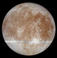
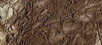
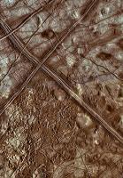
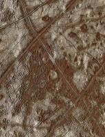
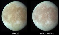
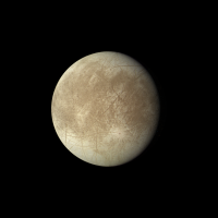
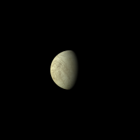
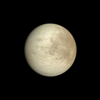
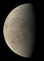
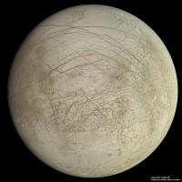
I have worked on sprucing up some global views of Europa from Galileo. There are a few more global views I hope to get to eventually. But the best two at nearly full phase benefited a lot.
http://img362.imageshack.us/my.php?image=europaviewsc6eh.jpg
[Moderator note: There are several more threads containing Galileo Europa images but they all contain several inactive image links. The main threads are:
http://www.unmannedspaceflight.com/index.php?showtopic=2016
http://www.unmannedspaceflight.com/index.php?showtopic=2174
http://www.unmannedspaceflight.com/index.php?showtopic=2222
http://www.unmannedspaceflight.com/index.php?showtopic=2082
http://www.unmannedspaceflight.com/index.php?showtopic=2142 ]
Posted by: deglr6328 Aug 22 2005, 05:45 AM
Wow, I do believe that bottom one is the most spectacular view I have ever seen of Europa. Well done! Is that one true color? Interesting to http://www.solarviews.com/raw/jup/europa.jpgit with what Voyager saw. 
Posted by: Bob Shaw Aug 22 2005, 10:00 AM
Yup. Verrrrrry good!
Posted by: edstrick Aug 22 2005, 10:12 AM
That Voyager view is the best color mosaic view, but the image quality of that version is poor. A bit fuzzy and with a bad color-cast.
Posted by: Decepticon Aug 22 2005, 12:23 PM
 WooHoo! My favorite LittleMoon! I love Europa.
Posted by: tedstryk Aug 22 2005, 12:41 PM

In my galileo mosaic, the color data is a mixture of two band data from the orbit, as well as a crude reprojection of data from other orbits. So the Voyager mosaic is best.
Posted by: tedstryk Aug 22 2005, 12:44 PM
In my galileo mosaic, the color data is a mixture of two band data from the orbit, as well as a crude reprojection of data from other orbits. So the Voyager mosaic is best.
I think the super-res effect really helped them.
Posted by: tedstryk Aug 22 2005, 02:40 PM
I think the super-res effect really helped them.
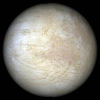
I am also working with Voyager...Here is the best Voyager 1 set, in OGB color.
http://img330.imageshack.us/my.php?image=eursupcv18xf.jpg
Posted by: tedstryk Aug 22 2005, 03:25 PM
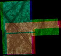
I have worked a bit more....I am having OGB Voyager problems. To the right is the image as produced through standard processing. To the left is a version edited to try to look more like a Galileo image.
http://img364.imageshack.us/my.php?image=eursupcompare7qh.png
Posted by: tedstryk Aug 22 2005, 05:29 PM
I just made an exciting "discovery" - well, a discovery to me...there is one more global color view in the Galileo set from the C10 orbit. I am surprised this hasn't been used more. The Color is IR-7560-Green-Violet. However, the green image clips the terminator, so that area is filled in with a synthetic green from the IR-7560 image and Violet image. The black and white image is a combination of a super-resolution image produced from the IR-9680, IR-7560, and Violet image, all of which were transmitted after being binned 2x2, and, for the areas available, the green image was then merged creating an even better product.
Posted by: Phil Stooke Aug 22 2005, 06:37 PM
Ted - fabulous! Keep it up!
Phil
Posted by: scalbers Aug 22 2005, 06:49 PM
These can be compared with the cylindrical map that is on my website at http://laps.fsl.noaa.gov/albers/sos/sos.html#EUROPA
Posted by: tedstryk Aug 22 2005, 07:10 PM
That map is awesome...I hve spent much time admiring it.
As for the color mosaic, I have tried many times to make it, but I have hit pitfalls. First, the lack of green data on the terminator. Second, when I try to fill it in with lower resolution data, it looks odd, since the green image is the only one sent back at full resolution. Third, the albedo patterns looked wierd, because the green filter data was used as for the grayscale. By making a super-res image from the binned imagery, I was able to prevent a great resolution drop on the terminator and was able to make a more realistic grayscale image without degrading it with low resolution input. By overlaying the green image over a synthetic green created from violet and IR data, I was able to make the end of the green image less noticeable.
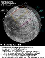
The only other galileo global shot of Europa was from the e17 orbit. I have crudely matched it with other color data here...I will put more time into this someday. I also plan to eventually work on the G1 data and merge it with some other data for a global view.
Posted by: JRehling Aug 22 2005, 07:20 PM
Phil
Ditto. My silence belies awe and gratitude.
John
Posted by: scalbers Aug 22 2005, 07:35 PM
Ted,
Your images are very nice as well, particularly the large gibbous view in post #1. One thing in particular I'd consider is comparing the hue and saturation realism to what I had used, namely the colors from Bjorn's map (that I may have tweaked a bit). Do you have a feel for the pros and cons of the color accuracy compared with Bjorn's? Both look pretty good to me - I wonder what new insights you have come up with. I'll reread your posts as well.
Posted by: paxdan Aug 22 2005, 07:49 PM
nice work on europa guys. It is so cool to see the images being properly reproduced instead of horrid stuff you still see in text books.
Posted by: tedstryk Aug 22 2005, 08:08 PM
Your images are very nice as well, particularly the large gibbous view in post #1. One thing in particular I'd consider is comparing the hue and saturation realism to what I had used, namely the colors from Bjorn's map (that I may have tweaked a bit). Do you have a feel for the pros and cons of the color accuracy compared with Bjorn's? Both look pretty good to me - I wonder what new insights you have come up with. I'll reread your posts as well.
Be careful of that image. The filter sets available were limited at best, and those used to produce the image vary throughout. Plus, some color data is from the actual set the grayscale image was made from, but a lot of it is from different orbits at different illumination angles. So the color, while processed to seem roughly realistic, is quite treacherous - a lot of guesswork went into it, and then I normed it a bit to fit the other images. As for the others, they are as accurate as I could make, but I can't directly compare them because I don't know how Bjorn's color was produced.
Posted by: Sunspot Aug 22 2005, 11:38 PM
How about trying the same with images of Io?
Posted by: tedstryk Aug 22 2005, 11:45 PM
I have thought of that. The only problem is that Io has much more color contrast than Europa (europa has some color contrast, but it is pretty predictable - Io's isn't). I am not sure if it would come out well or not. I may try.
Posted by: Decepticon Aug 23 2005, 12:37 AM
Keep them coming! Europa really deserves an orbiter.
Posted by: tedstryk Aug 23 2005, 03:07 AM
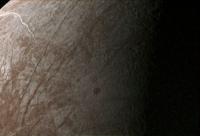
Well, I might work on some other moons, or try some mosaics. This is the only other global view of Europa I could find in the Galileo set that was worth combining with some color data.

Posted by: Bjorn Jonsson Aug 23 2005, 11:14 AM
Regarding my Europa map, the color there was taken from global Voyager images only. I used these to colorize higher resolution grayscale data (mainly clear filter). The reason I used Voyager and not Galileo data was higher resolution and IIRC Galileo had not imaged Europa globally in color at the time I made the map. I don't remember whether I used OGB or OGV (probably the latter) - I'm at work  and can't check it now.
I'm pretty sure the color is a bit too saturated in my map. It may too reddish as well, a common problem when the wavelength of the data used for colorizing is too short (e.g. O instead of R and/or V instead of B ).
I have been working on a much bigger Europa map (9000+ pixels in the horizontal direction) from time to time for more than two years. I have reprojected most of the high-res data I plan to use but haven't started working on the color. I plan to use Galileo images for color where possible, filling gaps (or very low-res areas) with Voyager data and/or synthetic color. I also expect to use synthetic B instead of V. The V images are more contrasty than the B images but mixing G and V should give a fairly good results (definitely better than using V only). One thing that complicates color work is Europa's photometric properties, limb darkening varies with wavelength and I prefer images as close to zero phase angle as possible.
Ted's images look fairly good, especially wrt sharpness but there are some saturation problems, caused both by saturation in the red images (this manifests itself as pinkish areas) and in all of the images in some cases (bright, white areas). I have some early 'test images' of Europa that look similar. And I should add that there is great color data at 1.4 km/pixel in the E14 data.
BTW Europa's color should be kid's stuff compared to Io. There is some information on Io's color on my experimental renderings page ( http://www.mmedia.is/bjj/3dtest/ ) and I will add more once I make my new map of Io available, I've been too swamped in data recently to update my website . In particular, it is impossible to use 'unmodified' IR7560 as red without seriously messing up the color balance.
Posted by: 4th rock from the sun Aug 23 2005, 12:50 PM
If you consider the Galileo filters and their wavelenghts, you have:
Violet - 404 : Green - 559 : Red - 671 : IR756 - 756 : IR968 - 968
The human color vision has a peak response of:
Blue - 440 : Green - 510 : Red - 650
So to "convert" the Galileo filters in to "human colors" we can mix images from different filters to get the proper wavelenghts.
I've calculated the ratios and corresponding wavelenghts:
75% Violet + 25% Green = blue (443)
70% Green + 30% Violet = green (513)
80% Red + 20% Green = red (649)
50% IR756 + 50% Green = red (658)
20% IR968 + 80% Green = red (641)
I've tried this on two Europa images and the results look good. Saturation is low, but that's expected when you mix the color data. Also, Europa looks white through a telescope anyway ;-)
|
|
Posted by: tedstryk Aug 23 2005, 03:45 PM
I experimented with filter mixes. Realistically, the problem is that Galileo image quality varies wildly depending on compression used. Also, it is rare to get a color mosaic without some bad gaps. But I did use similar mixes.
Bjorn: I see the problem in my large mosaic, but could you point out what you are talking about in my other images? I am not sure which spots you are referring to, and would like to know so I can try to correct the problem. Some of what you are seeing may be due to the fact that I jacked the contrast up on the posted images.
Posted by: Bjorn Jonsson Aug 23 2005, 04:25 PM
The pinkish areas are very prominent in the C10 image (the message dated yesterday at 05:29 PM), especially in the bright areas near the left limb and near Pwyll.
Posted by: tedstryk Aug 23 2005, 04:41 PM
This is a tweaked version.

And another.

Posted by: Bjorn Jonsson Aug 24 2005, 12:01 AM
These are better but still a bit pinkish. I'm not sure why - now that I'm at home and can have a look at what happened when I was processing these same images a few years ago I see I also had some problems with pinkish areas, especially near Pwyll. They were less pinkish but still pinkish.
Time to try to finish that 9816 x 4908 map of Europa I have been working on for two years, I should be able to get more realistic color for that map. I have now checked and seen that my current map of Europa was colorized using OGV as I thought. This means it is probably too reddish and saturated.
It is probably an interesting idea to check if there are any Cassini RGB (or CB1-GB) images of Europa near closest approach.
Posted by: scalbers Aug 24 2005, 05:14 PM
If you try the CICLOPS site and use their new search feature for "Europa" a couple of nice (if small) color images will pop up.
Posted by: Decepticon Oct 1 2005, 05:37 PM
Some "True Color" Images of Europa.
Somthing I found looking around. http://pirlwww.lpl.arizona.edu/HIIPS/EPO/gallery.html
Posted by: ljk4-1 Oct 7 2005, 03:13 PM
This could bode well for life on Europa (and Enceladus?):
Scientific American, 30 September 2005
http://www.sciam.com/article.cfm?chanID=sa003&articleID=000E134A-5B19-133C-9A8E83414B7F4945
Geologists have produced evidence of abundant marine life on the earth from a
period when others say a thick layer of ice gripped the entire planet. The find lends
considerable support to one side of a scientific controversy that has been widely debated for
decades.
The hullabaloo is over a glacial period dating to about 750 million to 600
million years ago.
Experts agree about the presence of ice on the planet then--even at the
equator--but how much and to what extent is still up in the air. Theories range from a "snowball
Earth" hard packed in kilometer-thick ice to a "slush ball Earth" characterized by thin ice and
areas of open water. The range of conditions would have impacted the microorganisms present.
Thick ice would have made life difficult for plants and animals, one line of reasoning goes,
choking oxygen out of the sea and blocking sunlight needed for photosynthesis. Mass extinction
would ensue and after the thaw, give rise to an explosion of multicellular life.
Posted by: Decepticon Oct 8 2005, 02:25 AM
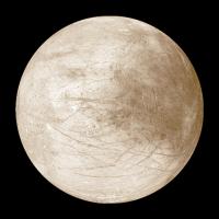
Has anyone here cleaned up this picture? It one of my favorite images of Europa http://photojournal.jpl.nasa.gov/jpeg/PIA02528.jpg
Posted by: Tayfun Öner Oct 21 2005, 08:19 PM
Here is a rendering using my map.
|
Posted by: Decepticon Oct 21 2005, 10:00 PM
WOW! Keeping that one!
Have anymore? Webpage?
Posted by: mike Oct 22 2005, 12:19 AM
So many moons and planets, so little time.. perhaps the Planetary Society will get enough money for a close inspection of Europa sometime soon.
Posted by: Decepticon Oct 22 2005, 02:26 AM
Europa has always capture my imagination.
I even dream of swimming around its oceans!
This leads me to a kinda off topic question. Has Europa ever been in a Hollywood movie besides 2010?
Posted by: Tayfun Öner Oct 22 2005, 05:43 AM
Decepticon,
I don't have a website but I have contributed many maps to Calvin Hamilton's Views of the Solar System. The above Europa image is created using the map at:
http://www.solarviews.com/eng/eurmap.htm
Posted by: Decepticon Oct 22 2005, 10:08 AM
Thanks!
Posted by: tedstryk Oct 22 2005, 12:23 PM
Great work! I have always enjoyed your work on Views. Great to see you in this forum!
Posted by: vexgizmo Dec 29 2005, 05:56 AM
Thank you all for the time and effort put into these beautiful Europa products! Ted, your E14-based Europa color mosaic is amazing. Sorry we couldn't get you that green-filter near-terminator strip returned to Earth....
-Bob P.
Posted by: ilbasso Dec 29 2005, 03:12 PM
Can you imagine how many spacecraft we could build if France, the UK, Russia, and the US stopped building warplanes for just one year and diverted the money to space hardware? I know that's totally fanciful, and I know we need planes, and our military plays a vitally important role (and my son is a helicopter pilot in the US Army)...but would it really "kill" us to go one measly year without building new ones? We could fund many of the projects we would so dearly love to do. Think how much we could learn about our solar system!
Add it to your New Year's wish list!
Has anyone totalled up the surface area of the moons and major asteroids, even just a rough order of magnitude, and compared it to the Earth's surface area? Isn't it amazing to think about how much unexplored territory there is in our solar system? Once we get the technology to visit them, the human race will be busy for decades crawling over every nook and cranny.
Posted by: ilbasso Dec 29 2005, 05:06 PM
Answering my own question: counting only the terrestrial and icy planets and moons, and not including any asteroids, comets or KBOs, the total surface area of the non-Earth "solid" solar system objects is roughly 281.7 million square kilometers, or about 2.2 times the total surface area of the Earth (including the oceans).
That seems low somehow.
But assuming it's correct, and assuming that an astronaut could explore 10 km^2 of surface area per day, it would take 28 million "person-days" to explore the surfaces of the moons and planets in our solar system. That sounds like steady employment well into the next century.
Posted by: vexgizmo Jan 21 2006, 09:44 PM
Here's a challenge that I hope one of you might accept. During the E12 Galileo orbit, there was a sequence of Galileo color images obtained of Conamara Chaos. Below is work by the Galileo SSI team to assemble these into color mosaics. This color imaging is enough to paint much of the famous E6 Conamara Chaos mosaic in true color (or near-true color extrapolated from 2 colors)--unfortunately we still only see this region painted by false bluish color based only on the E4 Europa albedo images. Can someone accept the challenge of painting Conamara with its true E12 color?
-Bob P.
|
|
Posted by: ljk4-1 Jan 22 2006, 12:51 AM
-Bob P.
Does anyone know what the composition of those brown areas are?
And did they come from the ocean floor?
Posted by: Myran Jan 22 2006, 03:20 AM
Im certain it would be possible to do that, I did some fast dabbling with the small one you provided, but as soon I zoomed in I noted the jpeg noise and well...at least I would feel it more rewarding to spend time on if one had a larger sized image than that so one wouldnt get artifacts from masking the various parts.
I include the quick dabbling I did for reference though.

Edit: Images where each colour channel would be separated would of course be the very best.
Posted by: David Jan 22 2006, 08:47 AM
That seems low somehow.
Most of that must be Venus (9/10s of Earth's total area, including oceans; a vast territory to explore, if one could only get to it -- drat that Venusian atmosphere!).
Given that Mars' surface area is about the same as that of the whole land area of Earth, and the Moon's is about the size of Asia, and there are only five bodies intermediate in size between Mars and the Moon, yeah, that seems about right.
Posted by: vexgizmo Jan 23 2006, 09:11 PM
And did they come from the ocean floor?
Probably sulfur-rich materials from charged particle bombardment of salts and/or sulfuric acid hydrate, which in turn may have churned upward from Europa's ocean. But no one is sure... part of why we need a new mission, with a better spectrometer.
Posted by: vexgizmo Jan 23 2006, 09:34 PM
Here is blue
|
Posted by: vexgizmo Jan 23 2006, 09:36 PM
...and green...
|
Posted by: vexgizmo Jan 23 2006, 09:37 PM
...and red (near-IR, really).
|
Posted by: Myran Jan 24 2006, 01:11 PM
Thank you vexgizmo for the samples, since the last one was near ir, and only covered a smaller part of the area I ended up working on two colours. Part reason was that while working on the image I noted that some stripe of the blue channel was out of aligment, seems to me it was one layer below where two others images have been pasted on top. 
But not entirely certain, I adjusted that at best of my ability though. In the end we see one completely unscientific interpretation of mine. 
http://img12.imageshack.us/my.php?image=e12exp6ww.jpg
Posted by: Exploitcorporations Jan 25 2006, 12:27 AM
A second, equally unscientific attempt at colorizing the E6 transect from your new data :
|
Posted by: vexgizmo Jan 25 2006, 12:43 AM
Gaw-geous!!! Are you able to colorize E6ESDRKLIN01 with this? And certainly not "my" data; Galileo's data! Well, everyone's data now
Posted by: Exploitcorporations Jan 25 2006, 04:11 AM
E6ESDRKLIN01...first attempt:
|
Credits-
Background mosaic: NASA/JPL
Color processing: Myron
Color overlay: Exploitcorporations
Concept: vexgizmo
Images:Galileo

Posted by: Exploitcorporations Jan 25 2006, 06:20 AM
Just for S&G, a badly tweaked version of the 1997 false-color JPL release:
|
Posted by: ljk4-1 Jan 26 2006, 06:11 PM
To quote:
Our good friend Arthur Clarke, who wrote of Europan life in his novels, in a letter dated 27 May 1997, described the picture as being the "most extraordinary ever received from space.......".
http://www.cf.ac.uk/maths/wickramasinghe/europa.html
Posted by: BruceMoomaw Jan 26 2006, 11:22 PM
Yes, and -- unfortunately -- he suggested, apparently seriously, the possibility that one of the bands in it was actually an artificial roadway mde by aliens. Alas, in his old age Arthur seems to have been possessed by the evil spirit of Richard Hoagland.
Posted by: Bjorn Jonsson Feb 2 2006, 11:35 PM
I have been trying to make (true ?) color images of Europa using mainly Galileo data. I am using red (IR756 in some cases), green and violet images. The violet images have considerably more contrast than the green images. Using Voyager images as a crude guide it seems the blue images have a contrast somewhere between the contrast in the green and violet images. Because of this I also made synthetic blue images as B=(G+V)/2.
I am attaching two preliminary versions of my images, one image using G1 data (IR756, G and V) and a C10 image (R, G, V). Images using V and synthetic blue are included. I should be able to get more realistic results in the future, the color balance is just a crude guess and it would be more accurate to use synthetic red instead of IR756. The red images have a bit higher contrast than the IR756 images so using synthetic red would be more realistic. Also it is probably not very accurate to use the exact average of green and violet as blue. A weighted average should be more accurate.
I eventually plan to use this to colorize a huge (roughly 10000x5000 pixels) global grayscale map of Europa I am working on. When complete it should be of slightly higher quality in terms of coverage than the USGS map. To colorize I need to remove limb darkening etc. because it varies with wavelength, making the color 'change' towards the limb. My biggest problem is that I do not know the wavelength-dependent photometric parameters for Europa. Does anyone know if Hapke parameters as a function of wavelength (or Galileo filter) are available somewhere ?
BTW I also did something similar (synthetic blue) for images of Io, see http://www.mmedia.is/bjj/3dtest/io/index.html for details.
|
|
Posted by: ugordan Feb 3 2006, 08:01 AM
Somehow the IR-G-V images look more "natural" to me than the ones with a synthetic blue channel. I find the orangish colors more natural than the pinkish ones using a synthetic blue channel.
That preference may have its roots in the Voyager imagery so one comes to expect an orange colored Europa -- not neccessarily its true color at all.
Posted by: Big_Gazza Feb 3 2006, 10:24 AM
Err.. this may be stupid question (here it comes...) but if my $150 digital camera can take a true(ish) colour picture in a single take, why can't space probes? (well, at least the modern ones built with digital technology). 
(this is where the image-processing experts roll their eyes and curse the ignorant noobs )
Posted by: edstrick Feb 3 2006, 11:39 AM
A consumer digicam usually has one CCD, and except for the Foveon CCD now being used in a few cameras, it cannot see all three colors with each hardware pixel. Instead, each pixel has either a red, green or blue single-pixel color filter in front of it. The standard design has a checkerboard pattern with 1/2 of the squares being green pixels and the rest are alternating red and blue.
When the data is read out from the CCD, smart software compares adjacent pixels and local brightness trends and makes a smart educated guess for what the missing two colors's brightness SHOULD be at the location of each pixel. It works. Pretty well. If you're not fussy.
That's why Pro-sumer video cameras often have 3 CCD chips and use special "dichroic" filters to let one color through and reflect another directly to that color's CCD. They're more sensative, since no photons are being absorbed, and each matched set of 3 pixels detects all the red, blue and green light that aren't randomly lost in reflection and transmission.
Spacecraft cameras, like Mariners, Viking Orbiters, Voyagers, Galileo and Cassini use one or two filter-wheels in front of cameras to swap a wide variety of filters in front of the single CCD, which you CAN'T do with a color-mosaic CCD like the ones in a consumer camera.
Some, like the MER camera filters split up the entire spectrum entering the cameras into fairly regularly spaced segments so a full set of narrowband MER filter images adds up to a 11 measurement spectrum of light entering the camera from violet to near infrared.
Galilleo and Cassini cameras also have narrow band filters that are specially designed to measure brightness in a narrow part of the spectrum. In their case, they measure light reflected from Saturn and Titan in bands where methane strongly absorbs, and you can use a set of methane and non-methane band images to measure the height <or depth> of clouds and hazes in the atmosphere. Cassini also has a set of polarizing filters to measure the polarized scattering of light by gasses and cloud/haze particles, which depends strongly on size and shape of cloud particles.
To take "TRUE-color" images, you have to design a set of color filters who's transmission varies with wavelength so that when combined with the transmission of the optics and wavelength dependent response of the camera CCD <or vidicon on old missions> you fairly precisely match the red, blue and green responses of "standard" color vision. To do that, you end up with a set of filters that are less ideal for scientific purposes, like estimating a surface spectrum as in the MER cameras.
MSR is planeed to have "hi-def" camera capabilities in color, and I suspect those detector/filters will be mosaic types, as in consumer cameras and camcorders. Even if color data from them won't be "full scientific grade" in quality, it will still be more useful for navigation and spotting "interesting" targets to look at closer than the monochrome hazcam and navcam images.
Posted by: Bill Harris Feb 3 2006, 01:35 PM
Good explanation, Ed. Photography is all smoke and mirrors, whether it be black and white, grayscale, color, silver halide or doped silicon.
--Bill
Posted by: Bjorn Jonsson Feb 3 2006, 02:09 PM
That preference may have its roots in the Voyager imagery so one comes to expect an orange colored Europa -- not neccessarily its true color at all.
The C10 (global) images look more 'natural' to me than the G1 images. This may be because I altered the color balance to make the area around Pwyll whitish whereas for the G1 image I didn't change the color balance. I should probably have changed it to something more similar to the C10 image. That said, I don't think Europa is as reddish as in the C10 RGsB image but I plan to use Cassini CB1GB images where both Europa and Jupiter are visible to see what Europa looks like when I process the image to make Jupiter's color balance similar to what one sees through a telescope.
Posted by: ugordan Feb 3 2006, 02:38 PM
You might have problems there because Cassini only used CB1 when it was still far away from Jupiter. Once the imaging plan changed to a 2x2 coverage footprint, they reduced the filter set and dropped CB1, leaving only CB2 as a close alternative. OTOH, I can't remember if they even kept the GRN filter coverage.
As a result, CB1 images of Europa are very distant and color differences will probably be unresolvable on such a small disk. My experiments with CB1 always resulted in Europa being more or less white.
There are a few RED/CB1 images taken near C/A IIRC, but they're severely underexposed, see http://www.unmannedspaceflight.com/index.php?showtopic=1807 on Cassini Galilean images.
Note that in no way am I saying those colors I got are even remotely accurate (in fact, they're probably very wrong), that attempt was primarily driven by me wanting to know how well Cassini could resolve the moons from such a distance.
Posted by: vexgizmo Feb 3 2006, 06:24 PM
Unfortunately, not yet for the Galileo data. This is the only photometric study I know of from the Galileo Europa data:
Helfenstein, P., N. Currier, B. Clark, J. Veverka, M. Bell, R. Sullivan, J. Klemaszewski, R. Greeley, R. T. Pappalardo, J. W. Head III, T. Jones, K. Magee, K. Klaasen, P. Geissler, R. Greenberg, A. McEwen, C. Phillips, T. Colvin, M. Davies, T. Denk, and M. Belton, Galileo obervations of Europa's opposition effect, Icarus, 135, 41-63, 1998.
The best from Voyager data is:
Domingue, D. L. and B. Hapke, Disk-Resolved Photometric Analysis of Europan Terrains, Icarus, 99, 70- 81, 1992.
Posted by: jrdahlman Feb 3 2006, 07:30 PM
edstrick's explanation made me think of a question of spaceprobe construction:
Why even use filter wheels at all?
Now that 1000 x 1000 pixel sensors are so cheap, we can load probes with as many cameras as we want. Look how many the MERs have. So instead of possibly-sticky mechanical wheels, or prism arrangements (imagine a gigantic 8-prism for 8 filters!), why not just have an array of 8 separate cameras all pointing the same way, each with its own dedicated filter?
Granted, for landers or other close-up features the parallax would be unacceptable, but for planetary flyby/orbits, parallax would be too tiny to see. (Wouldn't it?) Then it could take pictures with ALL the filters all at the same time--no motion shift between them! And you wouldn't even have to worry about 8x the data coming back, because you could still transmit them sequentially, or even decide which filtered pictures are worth sending.
How come they're not being built this way now?
Posted by: paxdan Feb 3 2006, 08:08 PM
Why even use filter wheels at all?
Now that 1000 x 1000 pixel sensors are so cheap, we can load probes with as many cameras as we want. Look how many the MERs have. So instead of possibly-sticky mechanical wheels, or prism arrangements (imagine a gigantic 8-prism for 8 filters!), why not just have an array of 8 separate cameras all pointing the same way, each with its own dedicated filter?
Granted, for landers or other close-up features the parallax would be unacceptable, but for planetary flyby/orbits, parallax would be too tiny to see. (Wouldn't it?) Then it could take pictures with ALL the filters all at the same time--no motion shift between them! And you wouldn't even have to worry about 8x the data coming back, because you could still transmit them sequentially, or even decide which filtered pictures are worth sending.
How come they're not being built this way now?
Because the cost of the sensor isn't the limiting factor, it is the size and weight of the camera(s). Mass and volume constraints are very tight on space craft. A filter wheel is a far more elegent solution to capturing a variety of wavelengths than duplicating the entire camera. A filter wheel weighs very little and occupies very little space, far far less than duplicating the sensor, optics and camera body multiple times.
The problem of motion shift is an interesting one for orbiters/flyby craft. There has been recent discussion regarding the use of 'sport mode' on the MER PANCAM. This cuts the interval between frames to 3 seconds from 10-20. While the interval between frames for Cassini is longer, one wonders wheather the use of subframe images or better routines will be able to squeeze a higher frame rate from the camera.
It is important to remember that spacecraft are primarily scientific instruments. Thus when spacecraft are designed, and choices made between returning scientifically calibrated data or pretty pictures the former must take priority and thus we should be thankfull that the latter is so often acheived as well.
Posted by: JRehling Feb 3 2006, 08:52 PM
Great stuff.
The area in the left image is an example of terrain where bright ice was seen to vary in IR brightness even though it was fairly uniform in visible. That might mean that it's impossible to interpolate/extrapolate between 756nm (near IR, actually just on the fringe of the visible spectrum) and 650nm (more of a central "red"). The differences between the "whites" can be seen vaguely in your image, and might not in "true" color. But beautiful stuff, and probably otherwise very on target, IMO.
Posted by: Decepticon Feb 4 2006, 12:17 AM
Exploitcorporations Did you find any global images that have not been seen yet?
Posted by: Exploitcorporations Feb 4 2006, 01:04 AM
No, that mine has been exhausted, and was unfortunately not very deep. Partial 1-4km scale mosaics were obtained on G1, E4, E6, G7, E12, E14, I25 and one nice full-frame view on E17. More distant, full-globe images were obtained on G2, C9, C10, G28, and I33. Eclipse and very distant plume search view were taken on C10 and C20. The exquisite color work seen here by Ted Stryk, Bjorn Jonsson, Mattias Malmer, and others covering these views, particularly the E14 mosaic, are as good as it gets.
Posted by: DDAVIS Jun 12 2006, 07:20 PM
Yup. Here is my initial attempt at this, which has been crudely colorized as well.
Don
|
Posted by: Decepticon Jun 12 2006, 08:38 PM
Nice!
Posted by: tedstryk Jun 13 2006, 04:18 PM
Yeah, global color views and what the Cassini folks would call "Kodak Moments" were some of the big losers to Galileo's woes.
C10 images were more intended to study the rings, but Europa happened to be there, and kind of stole the show. It is a pretty set, but is black and white.
The two C20 images are so underexposed and extremely noisy, making them almost unrecognizable. Here is the best I have been able to pull from them.
Posted by: mgrodzki Feb 12 2007, 12:22 AM
Don
that is one awesome image of europa. for one of the most important bodies in the solar system its shocking how few there are of this. #59 that is.
Posted by: remcook Mar 15 2007, 05:53 PM
pretty map
http://news.bbc.co.uk/1/hi/sci/tech/6454039.stm
Posted by: PhilHorzempa May 20 2007, 11:59 PM
The remarkable mosaics on the "Ganymede Revisited" thread got me thinking
about what might have been done for Galileo's Europa images on UMSF.
Lo and behold, there are earlier threads that included Europa mosaics. I say that
in the past tense because if you check out threads such as "Europa's Northern
Plains" and "Thera, Thrace, and Agneor Linea," then you will see that most, if not
all, of those mosaics are gone. It appears that the host for those data may no longer
exist, as such.
Can the members of UMSF re-create some of those Europa mosaics, which, from
the comments in those threads, were impressive?
Another Phil
Posted by: tedstryk May 21 2007, 12:46 AM
Exploitcorporations has a spectacular collection on her Flickr site.
Posted by: Exploitcorporations May 21 2007, 01:22 AM
Hi Phil. All of those mosaics are in reduced-scale form at the flickr link at the bottom of my posts now...the site they had been linked to was deleted in my long absence last summer. I will eventually have those dead links connected to the flickr page, and hopefully get those images up there at full size once I scrape enough change out of my sofa to get a paid account.
Posted by: tty May 21 2007, 05:58 AM
exist, as such.
As always in such cases: try the Wayback Machine (http://www.archive.org/index.php). At least one of the mosaics is available there.
Posted by: MarcF May 21 2007, 10:16 AM
Here is one mosaic I really like and which I found only recently:
http://berlinadmin.dlr.de/HofW/nr/080/
Just 4 pictures assembled out of 30 taken during E19 in order to search for plumes.
Anyway, the perspective is amazing !
Marc.
Posted by: ugordan May 21 2007, 12:10 PM
It's so nice to see mosaic footprints aligning nicely in Galileo imagery. That's what a scan platform and a fast camera gives you, I guess. Were it not for forced JPEG-like compression, the imagery would have been very crisp. The PSF of the Galileo SSI camera was pretty tight and images could be sharpened nicely. Galileo may have had a lower resolution CCD than Cassini, but the image crispness more than compensated for it. It really was a capable camera...
All the more reasons to regard the loss of the HGA as catastrophic. 
Posted by: tedstryk May 21 2007, 01:21 PM
Take a look at the raws from the lunar flybys. Gives you an idea of what could have been done had the antenna opened.
Posted by: MarcF May 24 2007, 10:00 PM
May be this is not really new, but I just found it on the USGS planetary nomenclature site:
The big albedo features (bright plains and mottled terrains) on Europa have now official names (as Regio):
Name (LAT / LON / DIAM) :
Annwn Regio (20.0 / 320.0 / 2,300)
Argadnel Regio (-14.6 / 208.5 / 1,900)
Balgatan Regio (-50.0 / 30.0 / 2,500)
Dyfed Regio (10.0 / 250.0 / 1,750)
Falga Regio (30.0 / 210.0 / 2,500)
Moytura Regio (-50.0 / 294.3 / 483)
Powys Regio (0.0 / 145.0 / 2,000)
Tara Regio (-10.0 / 75.0 / 1,780)
I already knew about Argadnel and Moytura Regiones, but the other names seem to be quite new.
Some new crater and Lineae names have also been assigned.
Marc.
Posted by: ugordan Dec 13 2009, 09:10 PM
Here's my version of the Europa 14ESGLOCOL01 mosaic using all color that was available. A lot of synthetic color at places, the terminator is pretty much only green filter data. Too bad about that huge gouge of missing data at upper left.
http://farm3.static.flickr.com/2497/4182003334_ee614d4ba8_o.jpg
Color balance was roughly based on a http://i108.photobucket.com/albums/n15/ugordan/cassini_europa_blowup.jpg showing pretty much an identical vantage point. Still slightly exaggerated colors, I think.
Posted by: CAP-Team Dec 13 2009, 10:36 PM
Nice work!
Posted by: tedstryk Dec 13 2009, 11:51 PM
Good work. I primarily stole from the G-1 mosaic to fill that nasty gap.
Posted by: ElkGroveDan Dec 14 2009, 12:35 AM
That is a fantastic image. It sure emphasizes the "bloodshot eye" appearance of Europa (but I have to go from memory as it has been years since I went to a college fraternity party).
Posted by: nprev Dec 14 2009, 12:44 AM
Really amazing work, G. The long troughs near the terminator really stand out in this view; don't recall seeing them as well in previous global mosaics.
Posted by: DrShank Dec 15 2009, 12:52 AM
the long troughs are part of a global pattern. several other troughs elsewhere form part of a set of two giant circles
on opposite sides of the moon. They actually match the stress patterns produced if you rotate Europa's floating ice shell
almost 90 degrees (aka polar wander).
check out the story at http://www.lpi.usra.edu/science/schenk/europaCropCircles/
paul
Posted by: machi Dec 24 2009, 10:44 AM
Merry Christmas to everyone on the site!
(It's one of the highest resolution mosaic of Europa from Galileo, with resolution around 10 m/pix horizontal. Artificially colorised by average color of this regio (Lat. -8.55;Long. 215))
|
Posted by: Decepticon Dec 24 2009, 07:10 PM
^ That just made my day! Amazing view.
Posted by: algorimancer Dec 25 2009, 02:06 AM
That is really nice. I especially like that sharp boundary between white above and dark below on the big fracture a little above center. I suspect the dark material must be sulfur compounds from Io settling on low areas of the surface, but it almost looks stratigraphic in that spot.
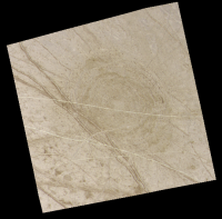
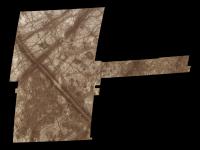
Posted by: machi Oct 24 2011, 11:06 PM
Little preview from Europa.
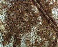
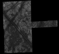
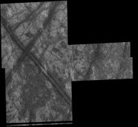
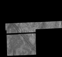
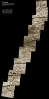
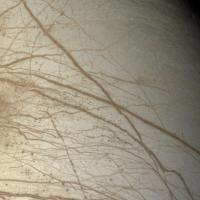
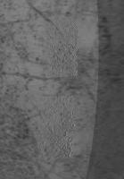
High resolution mosaic of Conamara Chaos (~12 m/pix). Image is colorized from lower resolution images (~200 m/pix)
This image is reduced in size (2×).

|
Posted by: elakdawalla Oct 24 2011, 11:10 PM
Wonderful!! I think this is the first time I have seen this mosaic without it being horribly saturated, and the color makes it even better. I love the pieces of ridges crossing rafts.
Every fine image from a Galilean moon that I see at UMSF makes me want to go back to Jupiter and do the Galileo mission properly, with a working HGA...
Posted by: nprev Oct 25 2011, 01:47 AM
(Sigh)...me too, Emily, me too. Sure wish we'd see something like that proposed in the RFP cycles...could probably do it on a less-than-Flagship budget these days.
Posted by: stevesliva Oct 25 2011, 01:55 AM
It would also be nice to have a few 10s of kilos of Pu-238.
Posted by: DrShank Oct 25 2011, 02:24 AM
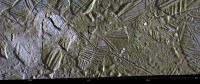
Every fine image from a Galilean moon that I see at UMSF makes me want to go back to Jupiter and do the Galileo mission properly, with a working HGA...
Nice work! here is my version from the Atlas of Galilean Satellites for comparison. scaled by 50% for upload
|
Posted by: elakdawalla Oct 25 2011, 04:25 AM
OK, that's pretty super too. I need to get my hands on a copy of that book. The guy running the booth at DPS/EPSC had packed up his display copies before I had a chance to bat my eyelashes at him and wheedle it out of him. (I did have success with that tactic at the Springer booth, got me the display copy of Michael Carroll's latest book, Drifting on Alien Winds. I've *really* been enjoying that one.)
Posted by: antipode Oct 25 2011, 11:23 AM
Wow - there are some substantial shadows there. How much vertical relief are we looking at on the edge of some of those....islands....rafts....Europabergs?
P
Posted by: machi Oct 25 2011, 12:34 PM
I can help with this little bit
Actually my new blog entry (planned) is about stereoscopic images from this mosaic. That mosaic has "only" supporting role (but at the end, it is better than I expected).
I think, that some cliffs are significantly more than 100 meters high and some are nearly vertical.
Little preview:
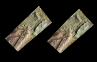
|
Posted by: stevesliva Oct 26 2011, 02:16 AM
To some extent there is hope for that with the flyby-oriented mission mentioned here:
http://futureplanets.blogspot.com/2011/10/europa-new-options.html
... a relatively heartening post. Interesting idea to split the super-rad-hard science that must be on an orbiter from the less-rad-hard science that can be on a Galileo-like flyby tour. Seems like a reasonable economy and not a false one.
Also... fantastic mosaics!
Posted by: tedstryk Oct 27 2011, 12:17 AM
I would love to see a Galileo-2 type mission. The Galileo team did, one could argue, almost too good a job salvaging science, making the false impression that we have really done an orbital tour of the Jovian system.
Posted by: volcanopele Oct 27 2011, 04:45 AM
I hate to burst everyone's bubble, but one of the ways they are making that flyby mission so low cost is by dropping Jupiter-system science.
Posted by: Bjorn Jonsson Oct 27 2011, 09:55 AM
Yes - and this is evident from the fact that the instruments are clearly optimized for close flybys only. For example, the camera has a field of view of 50 degrees (or something similar; I don't remember the exact number). After reading the orbiter and flyby PDFs I'd prefer flying the orbiter first, mainly because of my interest in a Galileo 2 style mission (there is no chance of a mission like that in the near future but no one knows what things are going to be like 10-20 years from now). Despite my interest in a 'Galileo 2', I think splitting the mission into an orbiter and a flyby spacecraft makes a lot of sense. The orbiter then becomes a Europa-specialized element.
One thing though: It now seems that ESA may do something 'Galileo 2-like' with JUICE (if that mission gets selected).
Actually my new blog entry (planned) is about stereoscopic images from this mosaic. That mosaic has "only" supporting role (but at the end, it is better than I expected).
I think, that some cliffs are significantly more than 100 meters high and some are nearly vertical.
Little preview:
I agree with Ted that the Galileo team performed a miracle in salvaging science but one of the consequences of the HGA failure is still that there is very limited stereo coverage of the Galileans (compare this with Cassini where there is a lot of stereo coverage for all of the icy satellites - for e.g. Rhea the coverage is global). So how are you getting stereoscopic images of Conamara Chaos? I don't think there's any stereo coverage there although I need to check this more carefully. This terrain was imaged during the E6 and E12 flybys and the viewing geometry was different but unfortunately the lighting geometry was different too so I don't think E6 and E12 can be used as stereo pairs (maybe I should try it though just in case).
Posted by: machi Oct 27 2011, 12:23 PM
Hmm, it looks "tasty".
It's kind of manual rewarping high resolution data to lower resolution one. It's difficult and time consuming and this is reason why I'll planned only one image from 5-images mosaic in stereo for now (but complete mosaic could be done in stereo).
And overlapping parts have evidently enough change in viewing geometry, that it's possible to make 4 small stereoscopy images (one of them is on the top of this page).
This is by the way good test for rewarping method.
Posted by: machi Oct 31 2011, 02:12 PM
New stereograms (both anaglyph and cross-eye versions) from Europa (with Conamara Chaos mosaic and others):
http://my-favourite-universe.blogspot.com/2011/10/4th-5th-6th-7th-8th.html
Posted by: Bjorn Jonsson Nov 1 2011, 12:16 AM
Wow, this looks awesome, both the images/mosaics and stereograms. Do you have any idea of how accurate the stereograms are? At least they look realistic.
I have now 'discovered' that there actually is stereo coverage of Conamara Chaos but unfortunately it's not the very hi-res E12 stuff - it's E6 images from ~19000 and ~6600 km. I'll run it through my stereo software one day but I don't know when - I have a big 'queue' of close to one thousand (!) images I want to run through stereo and/or shape from shading software. Doing shape from shading might be interesting as well but a possible problem there is albedo variations. Regarding the E12 images I suspect the viewing geometry for the adjacent, partially overlapping images in the E12 mosaic is too similar for stereo but I'm going to check it.
And finally let's not forget this great stuff from Paul Schenk:
http://stereomoons.blogspot.com/2009/09/broken-land-touring-conamara-chaos.html
http://www.youtube.com/watch?v=4N6UmW3yh1A
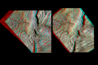
Posted by: machi Nov 1 2011, 05:39 AM
Thanks,
Accuracy of the stereograms http://3.bp.blogspot.com/-AJ9YkLUbXBQ/Tq17o2R7e9I/AAAAAAAAAC4/aArJXoH4X4I/s0/anConamara1913b.png and http://1.bp.blogspot.com/-M4fFsMOHXJk/Tq2CBDs2AnI/AAAAAAAAADQ/q_n1OXh2iLQ/s0/anConamara1913.png is dependent on the precision of my eyes and my experience.
Stereograms are made by warping in Sqirlz Morph using manually added control points. With these images, I achieved my personal record - more than 1800 control points.
"I have now 'discovered' that there actually is stereo coverage of Conamara Chaos but unfortunately it's not the very hi-res E12 stuff - it's E6 images from ~19000 and ~6600 km."
I used image, 7513R from orbit E6. This image covers whole mosaic, so theoretically whole mosaic can be done in stereo with similar results to Fig.5/6.
"And finally let's not forget this great stuff from Paul Schenk:"
Yes, I know his masterful work, after all Paul Schenk is guru of DEM models. This is reason why I'm doing stereograms and not DEMs.
I made little comparison, with similar geometry, between stereogram from two images with ~same resolution (1900 and 1913 from orbit E12, http://3.bp.blogspot.com/-t8FwQ_QBl-w/Tq2YTnUfHeI/AAAAAAAAADk/YCMaESezVzw/s0/Conamara_an1900-1913.png) and
manually warped version (http://3.bp.blogspot.com/-AJ9YkLUbXBQ/Tq17o2R7e9I/AAAAAAAAAC4/aArJXoH4X4I/s0/anConamara1913b.png), so you can judge both versions. http://3.bp.blogspot.com/-t8FwQ_QBl-w/Tq2YTnUfHeI/AAAAAAAAADk/YCMaESezVzw/s0/Conamara_an1900-1913.png is right image and http://3.bp.blogspot.com/-AJ9YkLUbXBQ/Tq17o2R7e9I/AAAAAAAAAC4/aArJXoH4X4I/s0/anConamara1913b.png is left image.
|
Posted by: ElkGroveDan Nov 1 2011, 01:19 PM
I think I would go blind.
Posted by: machi Nov 1 2011, 05:53 PM
I'm pleased, that someone has clue, how painful job this is.
Posted by: jasedm Nov 1 2011, 06:30 PM
Your pain is our gain!
Awesome, thanks.
Posted by: tedstryk May 3 2012, 04:42 PM
To celebrate the selection of JUICE, http://planetimages.blogspot.com/2012/05/europa-from-galileo-another-take.html
Posted by: Bjorn Jonsson May 5 2012, 01:40 PM
Very nice image that initially confused me a lot since I'm familiar with all of the Galileo global color coverage of Europa (or so I think). When I read where the color is from things became more clear.
Posted by: tedstryk May 6 2012, 06:02 PM
It is of course very approximate since the color data comes from very different illumination conditions. When it comes to Galileo data, one is often forced to really push things. I've tried for years to make a good fit for this, and it required fiddling with the gamma in the image and with a bit of filtering to compensate for the luminosity being based entirely on a violet filter image. This is the first version that didn't look to badly "off." Here is another version, on that might be my favorite, that is aesthetically slightly better.
|
Posted by: nprev May 6 2012, 06:43 PM
And there's my new desktop. Thanks, Ted!
Posted by: tedstryk May 6 2012, 07:13 PM
Your welcome...now if Juno and JUICE would hurry up 
Posted by: tedstryk May 6 2012, 08:23 PM
I should add that I removed noise by hand. There was a lot of noise in the image, but no automated removal did a good job removing it without wrecking havoc on the little ridges.
Posted by: machi May 8 2012, 11:05 PM
Beautiful image, Ted!
It is from orbit E17, isn't it?
BTW, for JUICE is planned NAC camera with 5 microrad resolution.
With this camera, JUICE will obtain two times better images of Europa even from the orbit around Ganymede (and with many filters).
Posted by: tedstryk May 9 2012, 12:29 AM
It is from orbit E17, isn't it?
BTW, for JUICE is planned NAC camera with 5 microrad resolution.
With this camera, JUICE will obtain two times better images of Europa even from the orbit around Ganymede (and with many filters).
Yes, that's it. Thanks. Trying to turn that violet image into a good "gray" image was a pain. I have made several previous attempts that were much less successful.
Wow, I hadn't read the specifications. Looking at the time this was taken, soon afterwards Europa transited Jupiter. Had Galileo had a working antenna, it would have made for one of the most spectacular movies ever.
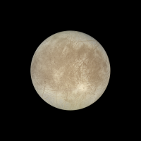
Posted by: Bjorn Jonsson Mar 12 2013, 12:39 AM
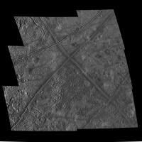
This is a mosaic of the Galileo I25 Europa images:
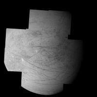
|
The 12 images comprising the mosaic were obtained on November 25, 1999 at a distance of 96000 km from Europa. This is the only good global coverage of Europa's Jupiter facing hemisphere. For aesthetic purposes I filled some narrow horizontal gaps by cloning nearby data.
For many years I have wanted to do something with the Europa images but didn't, mainly because a new mission that can image Europa at high resolution didn't seem that far in the future (a decade or so until Jupiter arrival isn't that much in this context). But now I have given up waiting - by now it has become pretty clear that nothing of significance is going to happen until almost 20 years from now when JUICE arrives at Jupiter. The good thing though is that this mission seems very likely to actually happen - more likely than previous mission concepts ever have been.
Because of this long time until the next spacecraft that can obtain hi-res images of Europa arrives I decided to start work on a 16384x8192 pixel global map of Europa using all of the useful Galileo and Voyager images. This mosaic is a 'by-product' from that project.
Interestingly the only mosaic I have found from the I25 data is only 900x900 pixels and has obvious seams since the brightness of the original images is variable:
http://photojournal.jpl.nasa.gov/catalog/PIA02528
Posted by: tedstryk Mar 12 2013, 12:50 AM
Great work! Oh, and I for some reason thought that this mosaic was much more spotty than this...wheels are turning in my head...
Posted by: kemcab2012 Mar 12 2013, 03:38 AM
Wow, Bjorn, that is beautiful! Really makes me want to go through the Galilean imagery and play around. Can't wait to see the final product!
Posted by: MarcF Mar 13 2013, 07:08 PM
Wow, really great job ! A stupid question: is it possible to overlay color data from lower resolution color pictures or are they of too low resolution ?
Thanks again for these amazing pictures.
Marc.
Posted by: Ian R Mar 13 2013, 09:03 PM
That's a lovely mosaic Bjorn: it really highlights some of the very subtle European topography, particularly the arc-like 'trenches' near the terminator.
Posted by: Bjorn Jonsson Dec 8 2013, 09:56 PM
It is well known that Galileo's color coverage of Europa is severly limited. I've been processing all of the Galileo color coverage that is useful for colorizing a huge (16384x8192 pixels) simple cylindrical map of Europa I'm working on. What I'm posting here are some of the more useful images. I'm still working on the well known E14 data so a color mosaic from that is not included. There is also a single 1.2 km/pixel color observation from E12 but it is extremely noisy and I'm not sure I'll get anything useful enough from it.
Very early in its mission, during the G1 non-targeted Europa flyby, Galileo obtained the best Europa color coverage of the entire mission in terms of the number of filters used. This is a planning image that appeared on the Galileo website. All of the data was downlinked and without gaps:
|
As shown above, only about 50% of the red image was downlinked. Fortunately, synthetic red images created from green and 756 nm images are remarkably accurate, the error compared to a real red image is typically ~1% or less. To get true color it's also necessary to create synthetic blue from green and violet. Here is a true color image from red (lower half), synthetic red (upper half), green and synthetic blue:
|
There is a well known false color image from these Galileo observations that can be seen http://photojournal.jpl.nasa.gov/catalog/PIA00275.
A few more Galileo true (or approximately true) color images, in all cases RGB from an infrared image, green and violet.
The G2 image from 968 nm, green and violet images with small gaps in some of the source images filled using data from another filter:
|
A C9 image from 756 nm, green and violet with small gaps filled as in G2:
|
A C10 image from 756 nm, green and violet with small gaps filled as in G2:
|
And finally a G28 image from 756 nm, green and violet. The color in this image is a bit strange and I haven't corrected it. I think the camera's calibration may have changed late in the mission and at least one thing definitely changed. From approximately orbit 26 the images appear less sharp than earlier.
|
In some cases I posted versions of these image several years ago but these new versions should be significantly better. In particular there is now no pinkish color around Pwyll in the C10 image.
And BTW: One unexpected 'discovery' I made while working on these is that a complete set of Galileo SPICE kernels apparently isn't available, for example the frames (FK) kernels are missing. I spent a lot of time searching but without finding a complete set of kernels. This was a big surprise to me.
Posted by: mcaplinger Dec 8 2013, 11:44 PM
Galileo predates the frames kernel concept, and it seems likely that no one has been motivated to go back and build them from scratch (we didn't have FKs for most of MGS either, but they were generated in 2007.) Some of that information is in the I kernels for the various Galileo instruments, though I didn't look at the C kernels to understand which frame(s) were in there. Historically image processing was done with the Euler angles in each image file.
Posted by: vexgizmo Dec 11 2013, 03:44 AM
Bjorn,
These are beautiful! There is one more not to forget: a color Europa mosaic on I33. Ted Stryk shows it here:
http://planetimages.blogspot.com/2005/09/i33-galileos-last-snapshots.html
Cheers,
-vexgizmo
Posted by: Bjorn Jonsson Jan 2 2014, 04:32 PM
Here is the I33 color image, the range is 1.9 million km. It's from 756 nm, green and violet. As in the G28 image in my previous post the color was probably a bit strange but here I attempted to correct it. I used the C10 color composite as a guide but I still have some doubts about the resulting color. Here the green image has been multiplied by 0.92 and the synthetic blue image by 0.98. The original images were rather blurry so the final image has been sharpened quite a bit:
|
And now two observations from the G7 flyby, one of the better non-targeted Europa flybys. Here is an approximately true color image of Tyre Macula from a distance of 30,000 km. It's created from from 968 nm, green and violet images. This is from AI8 summation mode images so the resolution is ~600 m/pixel. North is up. A fairly well known false color version from the same data can be seen http://photojournal.jpl.nasa.gov/catalog/PIA00702. But here is the true color image:
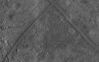
|
And here is a four frame mosaic from the G7ESAPEXCR observation. The resolution is ~500 m/pixel. Actually this observation consisted of five frames but only a tiny strip of frame three was downlinked. For context, lower resolution data is included. In general this terrain is relatively poorly imaged.
|
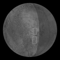
And here is a schematic global view showing the location of the G7ESAPEXCR observation. The subspaccraft longitude is ~115 degrees west. I used a slightly modified version of the USGS Europa map.
|
Processing the Galileo data can be horribly frustrating. I inevitably start thinking of what could have been. Galileo flew by Europa at a range of 25,000 km during the G7 orbit - and with relatively poorly imaged terrain in view. Under normal circumstances it could easily have imaged this entire terrain at 1 km/pixel or better - and at several wavelengths. Hundreds of images would have been acquired during the G7 Europa flyby. But due to the HGA failure this was not possible, only a tiny part of this terrain was imaged at 1 km/pixel or better. And the reality is that considering how disastrous the HGA loss was, what Galileo managed to do over its mission really was a miracle.
Posted by: MarcF Jan 11 2014, 10:48 PM
I love these mosaics of Europa. I just realize that the upper image of the G7ESAPEXCR observation corresponds to the region observed by Galileo NIMS and where clay-like minerals have been detected:
http://www.nasa.gov/jpl/news/europa-clay-like-minerals-20131211.html#.UtHIpUrpz7I
A big impact structure should be localized just to the east, but no secundaries are visible.
I have never seen the SSI and NIMS data associated, may be it would be interesting to superpose them.
Regards,
Marc.
Posted by: JRehling Jan 12 2014, 04:22 PM
Great images, Bjorn.
I wonder if a color model of Europa could be constructed that assumes that the composition (in terms of color, not necessarily chemically), locally, is always at some point on a continuum between icy and non-icy. Then the limited set of color images could be used to model the obviously complex photometry function of both the icy and non-icy terrain, and re-render any B/W images according to that model. It seems like in the case of Europa, a model that simple wouldn't be far from the mark.
Posted by: Bjorn Jonsson Jan 13 2014, 12:38 AM
There is bright terrain just east of the upper part of the G7ESAPEXCR observation but the resolution there is low and it's not far from the limb in the best images that show it so it's difficult to tell what it is.
Interesting idea - this might work. The darker terrain is usually redder but it would probably be difficult not to confuse topographic shading with albedo variations unless the solar elevation angle is high (i.e. there are no shadows). It has occurred to me to 'cheat' (either manually in Photoshop or semi-automatically somehow) when colorizing hi-res B/W data with low-res color data. The problem is that the more reddish color of the narrow 'bands' can 'spill' into the adjacent bright terrain if there is a very big difference in resolution. This problem is especially severe in the leading hemisphere where I have to use the 12 km/pixel C9 data to colorize the 1 km/pixel I25 data.
Posted by: scalbers Jan 13 2014, 08:09 PM
I've had fairly reasonable results in the past combining low res color (from Bjorn) and hi-res black and white as can be recalled here:
http://laps.noaa.gov/albers/sos/sos.html#EUROPA
I've been thinking of redoing this mosaic if I can easily obtain the latest 8K or even higher USGS map of Europa.
I understand the bleeding potential though. I wonder if somehow a local color table can be constructed to help with this, if you catch my drift. I'm not really that familiar with fancier methods of colorizing.
Steve
Posted by: Bjorn Jonsson Jan 15 2014, 12:08 AM
A 500 m/pixel (19631 x 9816 pixels) version is available at the USGS website and it should be geometrically very accurate. Interestingly, it doesn't include some observations that could have been used to increase the resolution in some parts of the map, for example the 14ESTYREHR01 and 14ESWEDGES01 observations and some of the G7 observations. I'm using all of these in the map I'm working on (which has now grown to 20000 x 10000 pixels). In total I expect to use approximately 200 Galileo and Voyager images.
Posted by: JohnVV Jan 18 2014, 09:53 PM
-- this is BASED on the USGS map
if all you want there is a 8192x4096 color map in my celestia add on
http://www.celestiamotherlode.net/creators/johnvanvliet/Europa_2k_4k_8k.zip
or
if you do not mind untilling the 16384x8192 color map
( it is chopped into 512x512 px. tiles)
http://www.celestiamotherlode.net/creators/johnvanvliet/VT/EuropaLevel_4P1.zip
http://www.celestiamotherlode.net/creators/johnvanvliet/VT/EuropaLevel_4P2.zip
http://www.celestiamotherlode.net/catalog/show_addon_details.php?addon_id=1176
if needed i could post a full sized image on my google drive
Posted by: TheAnt Jan 20 2014, 03:08 PM
@JohnVV: Once again I get reminded how much this moon cries out for exploration. At least for full mapping at decent resolution.
Just imagine a surface formed by the convection by warm and colder ice!
In the areas where we got high resolution one can see some craters after all, the rate somewhat similar to Triton. Though the process that is thought to have eradicated craters on the latter is thought to have been transient yet quite dramatic.
Meaning that the less obvious multi-ring impact features on both look similar at first glance yet do so for somewhat different reasons.
So thank you for your work, including Bjorn Jonsson / scalbers of course also-it is good to have until we will have a mission to Europa.
( Since one orbiter for Triton is not even in the pipedram stage - unless we make a collective effort here to hijack BepiColombo. )
Posted by: Bjorn Jonsson Feb 11 2014, 09:30 PM
An approximately true color composite from 756 nm, green and violet. This is from images obtained during the E12 orbit.

|
Not exactly impressive but the source data is extremely noisy and getting rid of all of the noise is difficult without losing lots of details, especially in the narrow ridges near the terminator. The source images were obtained at a range of 135,000 km on December 16, 1997. North is up and the resolution is 1.4 km/pixel.
The crater Pwyll is the dark spot above center and the western end of Agenor Linea is visible at lower right.
Posted by: tedstryk Feb 12 2014, 10:59 AM
Wow, impressive. I know what you had to work with.
Posted by: machi Feb 12 2014, 02:19 PM
Beautiful result for such noisy data. I'm looking forward to your map of Europa!
Posted by: Bjorn Jonsson Apr 25 2014, 02:12 PM
Conamara Chaos revisited
Conamara Chaos was particularly well observed by Galileo. Others (especially machi) have posted great versions of the E12 hi-res images so here I'm concentrating on the E6 images plus the E12 color images. Here is a 2x3 mosaic from a range of 19000 km. It shows all of Conamara Chaos below the big "X" feature:
|
About 40 minutes later Galileo obtained four hi-res images of southern Conamara Chaos from a range of 6600 km. Here they have been blended into the big mosaic. This version shows all of Conamara Chaos:
|
During orbit E12 Galileo obtained the well known ultra hi-res images that have appeared earlier in this thread. But it also imaged Conamara Chaos in violet, green, 756 nm and 968 nm from a range of 18000 km. This is an RGB version from the 756 nm, green and violet images:
|
I had to create a synthetic 756 nm image from green and violet for the center of the "X" feature and everything above it but this worked very well when I used a non-linear formula instead of the more common w*GR+(1-w)*VI. I then created synthetic red and blue images.
It's interesting to combine the color data with higher resolution data. This was posted way back in 2006 (!) by vexgizmo:
Others have done a very good job with the true color earlier in this thread so I'm not repeating that (even the very hi-res E12 images have been nicely colorized). But I noticed that there seemed to be some very subtle color variations and it is also well known that the dark terrain is redder than the light terrain. I wanted to clearly show these color variations and after some experimentation I came up with the following image where the IR756/green ratio is displayed as red, green simply as green and the violet/green ratio as blue. I then used this to colorize the E6 data (both the hi-res data and the lower resolution data):
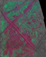
|
The features that appear red or purple are 'redder' than the greenish/cyan terrain. This reveals lots of interesting things. One particularly interesting observation is that the matrix in Conamara Chaos is usually redder than the large blocks with ridged terrain. A look at page 267 in Europa published by University of Arizona Press (a must-have for anyone seriously interested in Europa) confirms this. Another interesting thing is the Pwyll ejecta. The two grayscale images near the top of the post show a north-south ray of bright ejecta material from Pwyll that overlaps western Conamara Chaos (this ejecta is particularly obvious in the G2 global image). In the false color image the westernmost part of Conamara Chaos has a strong green color caused by the ejecta. What I find interesting is that in this area both the matrix and the rafts are green. Is this evidence that Pwyll is younger than Conamara Chaos? At least I think I have managed to find a particularly good example of just how useful color/multispectral data can be.
All of the images above are in orthographic projection with the subspacecraft point at lat=11.5, lon=273. North is up. The images here are slightly bigger than the originals to avoid loss of details from the many resampling and reprojection steps.
Posted by: tedstryk Apr 25 2014, 08:48 PM
Lovely work! I'll also add that the shapes of Galileo mosaics are sort of a signature.
Posted by: eoincampbell Apr 26 2014, 02:43 AM
Thanks for sharing...what a wonderful tour of jigsaw junction...
Posted by: DrShank Sep 5 2014, 08:08 PM
Accuracy of the stereograms http://3.bp.blogspot.com/-AJ9YkLUbXBQ/Tq17o2R7e9I/AAAAAAAAAC4/aArJXoH4X4I/s0/anConamara1913b.png and http://1.bp.blogspot.com/-M4fFsMOHXJk/Tq2CBDs2AnI/AAAAAAAAADQ/q_n1OXh2iLQ/s0/anConamara1913.png is dependent on the precision of my eyes and my experience.
Stereograms are made by warping in Sqirlz Morph using manually added control points. With these images, I achieved my personal record - more than 1800 control points.
"I have now 'discovered' that there actually is stereo coverage of Conamara Chaos but unfortunately it's not the very hi-res E12 stuff - it's E6 images from ~19000 and ~6600 km."
I used image, 7513R from orbit E6. This image covers whole mosaic, so theoretically whole mosaic can be done in stereo with similar results to Fig.5/6.
"And finally let's not forget this great stuff from Paul Schenk:"
Yes, I know his masterful work, after all Paul Schenk is guru of DEM models. This is reason why I'm doing stereograms and not DEMs.
I made little comparison, with similar geometry, between stereogram from two images with ~same resolution (1900 and 1913 from orbit E12, http://3.bp.blogspot.com/-t8FwQ_QBl-w/Tq2YTnUfHeI/AAAAAAAAADk/YCMaESezVzw/s0/Conamara_an1900-1913.png) and
manually warped version (http://3.bp.blogspot.com/-AJ9YkLUbXBQ/Tq17o2R7e9I/AAAAAAAAAC4/aArJXoH4X4I/s0/anConamara1913b.png), so you can judge both versions. http://3.bp.blogspot.com/-t8FwQ_QBl-w/Tq2YTnUfHeI/AAAAAAAAADk/YCMaESezVzw/s0/Conamara_an1900-1913.png is right image and http://3.bp.blogspot.com/-AJ9YkLUbXBQ/Tq17o2R7e9I/AAAAAAAAAC4/aArJXoH4X4I/s0/anConamara1913b.png is left image.
always nice to see these products get some attention! be in known that i am finally (!) at last putting the stereo and PC DEM story of Europa together for submission later this year, complete with a web page of jpegs and the like. it will take 2-3 months of work to get everything ready for release but it should be pretty cool. soon . . . !
Posted by: tedstryk Nov 21 2014, 08:14 PM
NASA has released an exquisite new version of http://www.jpl.nasa.gov/news/news.php?feature=4386 along with a nice promo video for exploring it.
Posted by: Bjorn Jonsson Nov 30 2014, 05:32 PM
It is a pleasant surprise to see this released after all these years. This is a very high quality mosaic, the best version from these particular source images that I have seen. A very 'clean' image and the color channels are perfectly aligned (I sometimes need to warp indvidual color channels slightly to get rid of small 'residual' alignment errors when processing color images). The color isn't as realistic here as in Ted's version though since the red channel is from near-IR images and this is not corrected for (at least not fully).
For comparison, here is a test render from a 20000x10000 pixel true color global map I'm working on. It's shaded using a slightly modified Hapke function:
|
As should be obvious, this is not the final version of the map. The poles look strange and the color may change a bit in later versions, at least in the northern hemisphere near the terminator. Actually it is remarkably difficult to create a global true color map of Europa. The surface contrast varies with phase angle (less contrast at low phase angles) and the color also varies with changes in viewing/illumination geometry. Or in other words, the photometric parameters vary with wavelength. For example limb darkening increases with increasing wavelength. I haven't found any information on exactly how the Hapke photometric parameters vary with wavelength but if I find information on this (or figure out myself how the parameters vary) I should be able to render more realistic views of Europa uisng the big map I'm working on.
It will be very interesting to see this.
Posted by: Bjorn Jonsson Dec 20 2014, 10:51 PM
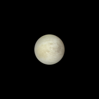
One by-product from the 20000x10000 global map of Europa I'm working on is that I now have a global true color map from all of the useful color images that have a resolution ranging from ~1.2 km/pixel to ~15 km/pixel and this can be used to colorize clear filter images and mosaics. Here is a colorized version of the I25 mosaic in http://www.unmannedspaceflight.com/index.php?showtopic=1300&view=findpost&p=198922. The color is mainly from the C9 global image but a bit also comes from G2.
|
The color should be fairly close to Europa's true color.
Posted by: nprev Dec 21 2014, 12:24 AM
Gorgeous, Bjorn.
Posted by: jgoldader Dec 22 2014, 02:41 AM
Speechless
Posted by: Bjorn Jonsson Feb 2 2015, 10:40 PM
Today, it seems that NASA is at last committing to flying a mission (probably Europa Clipper) to Europa after years of studies. By a strange conincidence, on this same day I may have finally finished the 20000x10000 pixel map of Europa I've been working on for almost 2 years (!) (but with major breaks to do several smaller projects). All that remains is to check for images I might have overlooked that I should have included in the map (I don't expect to find any). The map should include almost every image down to a resolution of ~200 m/pixel plus a selection of several higher-res images.
Here is a 4000x4000 pixel test render showing the hemisphere with the best imaging coverage, including a pole-to-pole strip left of center at higher resolution than most of the map.
|
Due to upload size limitations I couldn't upload a bigger version here; a bigger (6000x6000 pixels) version can be seen here: http://www.mmedia.is/bjj/data/europa/europa_newmap_color_8b_6000x6000.jpg
I'm looking forward to the day when *all* of this terrain has been imaged at better resolution than here by JUICE and/or Europa Clipper. I want my Europa map to become completely outdated as soon as possible!
Posted by: Explorer1 Feb 2 2015, 10:42 PM
Desktop'd as usual, Bjorn.
Not much else to say... fantastic as always.
Posted by: stevesliva Feb 3 2015, 01:21 AM
I noticed that and assumed that was where Galileo had images things at a higher resolution... am I to understand to that the entire hemisphere has similar resolution in your map? Wow.
Posted by: Bjorn Jonsson Feb 3 2015, 11:08 AM
No, not all of the map has this resolution. This north-south strip is from Galileo's ~200 m/pixel regional mapping which covers a relatively small part of Europa (probably most/all of Europa would have been imaged at this resolution or better had Galileo's HGA worked). In addition to this N-S strip there are several more areas at similar resolution but most of the map comes from images with a resolution of ~1.5 km/pixel. There are also areas where the source image resolution is lower though - only 4-15 km/pixel.
The map's size (20000x10000) translates into slightly better than 0.5 km/pixel resolution where the source data allows.
Posted by: Ian R Feb 3 2015, 12:25 PM
A mighty congratulations are in order, Bjorn! The culmination of a two-year project of this magnitude is something to be celebrated, and I hope you get the recognition and plaudits that this achievement so richly deserves.
Ian.
Posted by: algorimancer Feb 3 2015, 03:06 PM
The full resolution version is pretty amazing -- someday it would be really nice to have a Google Earth version, like we have for Mars. A lot of details pop-out which I hadn't dwelled on previously. There are a scattering of large berg-like features, almost like boulders lying partially submerged in the surface; if we posit the thin ice shell model, these may arguably be spots where the shell has doubled-up (stacked one layer on another). I'm out of touch with Europa research, but it seems like someone ought to have studied these in depth, perhaps modeled and measured their displacement of the surrounding surface, perhaps established whether they are in hydrostatic equilibrium. Neat stuff.
Posted by: machi Feb 3 2015, 11:55 PM
True masterpiece Bjorn!
It's really pity that we haven't good topography data. It would be really tempting to combine your excellent map with some nice topography data.
Hopefully it will be possible some 20 years later with data from new Jupiter system missions.
Posted by: tedstryk Feb 6 2015, 12:36 AM
Beautiful work, Bjorn! That may be the smoothest looking global rendering of anything from Galileo data I have ever seen.
Posted by: Bjorn Jonsson Feb 18 2015, 08:55 PM
My brand-new 20000 x 10000 pixel map of Europa can now be seen here: http://www.planetary.org/blogs/guest-blogs/2015/0218-mapping-europa.html
This is by far the biggest image processing project I have ever undertaken in terms of time and number of images (but not complexity). I now have a big directory tree associated with this image processing project; it consists of about 50 GB in 2500 files and 135 folders (!). A lot of it is temporary stuff though that can be deleted.
Posted by: ectoterrestrial Feb 19 2015, 07:59 PM
This is by far the biggest image processing project I have ever undertaken in terms of time and number of images (but not complexity). I now have a big directory tree associated with this image processing project; it consists of about 50 GB in 2500 files and 135 folders (!). A lot of it is temporary stuff though that can be deleted.
Wow, Bjorn! Thank you for this.
What is your impression of the red-yellow hemispheric dichotomy? Could it be an observational bias, or due to reflected Jovian light?
Posted by: Bjorn Jonsson Feb 20 2015, 03:53 PM
It's neither of these. The color/brightness difference is real, Europa's leading hemisphere is brighter than the trailing hemisphere.
Posted by: nprev Feb 20 2015, 06:59 PM
Please correct me if I'm wrong, but I thought that the hemispheric color asymmetry was thought to be due to the leading hemisphere being subjected to the brunt of Jupiter's radiation belt as the moon orbits thus causing decomposition of volcanic effluent deposits from Io (which aren't subjected to that on the trailing hemisphere & therefore persist.)
Posted by: ectoterrestrial Feb 20 2015, 08:25 PM
Its slightly more complicated than that.
The Jovian magnetosphere rotates faster than Europa's orbital velocity at Europa's orbital radius.
As a result, Europa is getting bombarded by charged particles on it's orbital trailing hemisphere. It is also picking up uncharged particles and dust from it's orbital motion on the leading hemisphere.
One obvious result of this is the hemispheric color/albedo contrast.
I knew that the orbital trailing hemisphere showed signs of enhanced "weathering" but I did not realize the magnitude of the contrast. Bjorn's processing really brings this maps alive for me.
Powered by Invision Power Board (http://www.invisionboard.com)
© Invision Power Services (http://www.invisionpower.com)