Printable Version of Topic
Click here to view this topic in its original format
Unmanned Spaceflight.com _ Mars Odyssey _ USTRAX! Here is your Abyss.
Posted by: Marslauncher Mar 17 2007, 09:58 AM
http://news.bbc.co.uk/2/hi/science/nature/6461201.stm
Scientists studying pictures from Nasa's Odyssey spacecraft have spotted what they think may be seven caves on the surface of Mars.
well I guess that makes habitats a much easier task of creating now, plus with whatever we find in the walls of Valles Marineris.
Posted by: Rakhir Mar 17 2007, 10:22 AM
It may be a nice target for HiRISE !
Posted by: Toma B Mar 17 2007, 10:42 AM
Wow! 
Nice place to send Robot-Speleologist...
I wonder if there are bats inside...
Posted by: JTN Mar 17 2007, 11:12 AM
Here's the http://www.lpi.usra.edu/meetings/lpsc2007/pdf/1371.pdf. The http://www.nature.com/news/2007/070312/full/070312-11.html suggests off-nadir HiRISE observations.
Posted by: MarsIsImportant Mar 17 2007, 03:10 PM
I'm not too surprised at all about this find. I've suspected some small but collapsed cave like structures on some of the HiRISE JP2 images. These particular ones from Odyssey are HUGE. It causes me to raise an eyebrow or two! ...but only because it seems to support what I already suspected.
I suspect there is an extensive network of caves throughout many parts of Mars that will not easily be detected from satellite. Most of the larger structures should be very deep underground (kilometers). The Martian crust may look sort of like Swiss cheese. Perhaps MARSIS can help in detecting some of the relatively shallow ones.
This discovery only provides hints as to where both the missing water and atmosphere on Mars may have disappeared to. Deep underground there maybe caves where the atmospheric pressure is great enough for stable liquid water or ice. I'm talking about places that would be measured in kilometers. But we maybe waiting for a very long time for the REAL evidence because it won't be so easy to find.
Posted by: tasp Mar 17 2007, 03:40 PM
B)-->

I wonder if there are bats inside...
[/quote]
Martian obsidian piranha bats.
Quite dangerous, but very tasty!

Posted by: nprev Mar 17 2007, 03:51 PM
Even more exciting, what about ancient sulfate stalactites, or pegmatite dikes filled with Martian tourmalines? The mind reels...
Posted by: tasp Mar 17 2007, 03:53 PM
Would we recognize a kimberlite pipe in any of the photos?
Posted by: MarsIsImportant Mar 17 2007, 04:37 PM
It sounds like, if these extensive cave networks don't exists now, they will in the future--from human activity. I think there is little question that some of these rocks exist somewhere on Mars. But where? The answer to that question would go a long way to financially support human colonization of the place.
Posted by: tty Mar 17 2007, 05:28 PM
Considering the surrounding terrain and location these would seem to be lava caves, not karst caves. This means that they may be quite extensive (or at least long), but not very deep. And no stalagmites/stalactites unfortunately.
As for kimberlite pipes, yes they would probably be visible in a HiRise image, if they aren't covered by loose material (a very big if!). However it is far from certain that they even occur on Mars. Kimberlite pipe genesis is not well understood, so it is difficult to judge whether conditions on Mars are suitable.
Posted by: nprev Mar 17 2007, 05:57 PM
We need to know more about these for many reasons, not the least of which is that they might be a nice cost-effective place to set up a base if they're extensive and capable of being sealed off...good way to get out of the UV & avoid flying a lot of shelter hardware to the surface.
Posted by: dvandorn Mar 18 2007, 12:54 AM
My only concern for the suitability of these caves to human habitation is that, being volcanic (empty lava tubes and such), the only occur in regions of "recent" volcanism.
These are the most boring places on the planet, IMHO.
Also, if these cave systems are all located near and within the big volcanoes in Tharsis, then how easy is it going to be to stage useful exploration from the side of a mountain in the middle of the highest-above-datum portion of the planet? How easy is it going to be to simply deliver the gear we'd need to bring from Earth to such a location? Not a lot of atmospheric braking, that high above datum.
Now, if there was a reasonable expectation of finding cave systems branching out from the floors of the deep valleys -- *that* would be an excellent place to look for life and to dig in for human habitation.
-the other Doug
Posted by: SFJCody Mar 18 2007, 08:02 AM
http://adsabs.harvard.edu/abs/2005LPI....36.1051B
Meridiani caves?
Posted by: pch Mar 18 2007, 09:58 AM
Yes, you can found stalactites in basalt cave!
When I was younger I do a lot a caving.
In 1982 we stay a few month in Hawaii to survey lavatube and climb down many pit like this one.
This look very similar to the pictures in article.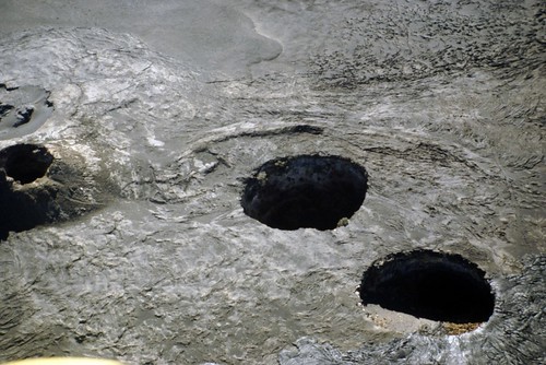
At the bottom of Mauna Ulu crater that was in eruption from 1969 to 1974 we found a cave, in fact the roof of a magma chamber, with many sulfate stalactites and stalagmites up to 1 meter in length.
They formed in less than 6 years from water drainage in the subjacent basalt.
Is this possible on Mars ? sure that Kau desert is a very wet place by comparison.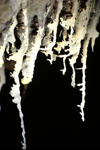
There is also basalt stalagmites in some lavatube:
But not sure if such a structure can survive billion of years.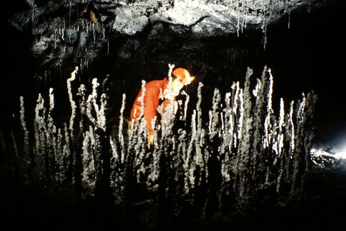
Posted by: edstrick Mar 18 2007, 10:05 AM
Lave-tube igneous speleothems will be about the same on Mars <and Venus, and Io> as on Earth.
Solution/Deposition speleothems are a whole different catetory. I suspect that low-altitude caves on Mars could well have sulfate mineral speleothems. If the "razorbacks" at Meridiani required liquid after the dunes were lithified and later fractured, than such mineral deposits could form in cave-like voids (or small solution cavities... sulfate geodes, anyone?)
Posted by: tasp Mar 18 2007, 01:46 PM
An examination of broken stalagmites and stalactites might generate information on past marsquakes.
Might be an interesting line of inquiry.
Posted by: nprev Mar 18 2007, 03:52 PM
Agreed...would love to see cross-sections of same!
Can you imagine sending a rover into one of these? Talk about autonomous nav...the PI would be biting his or her nails down to the elbow until it finally emerged & called home...
Posted by: edstrick Mar 19 2007, 09:19 AM
http://www.stoneaerospace.com is getting ready to send the Depthx submersible robot to autonomously map and navigate in realtime from the map, the ?world's? deepest cenote/solution spring.
Stone also wants to go to the moon...commercially.
Posted by: ustrax Mar 19 2007, 10:22 AM
Better someone innoculate Glen Cushing with that anti-Ultreya vaccine...

Posted by: helvick Mar 19 2007, 10:36 AM
Bill Stone is definitely a man to keep an eye on. He http://blogs.indiewire.com/steve.rosenbaum/archives/012976.html with his plan for a manned exploration mission to Shackleton crater equipped with only enough fuel for the outbound trip pour encourager les explorers to well, like, explore.
He's definitely the man for this job too - he http://video.google.com/videoplay?docid=5797001505961854840.
Posted by: ustrax Mar 19 2007, 11:49 AM
Here they are...
http://i16.photobucket.com/albums/b14/ustrax3/Possible%20caves%20on%20Mars/cave06.jpg
http://i16.photobucket.com/albums/b14/ustrax3/Possible%20caves%20on%20Mars/cave05.jpg
http://i16.photobucket.com/albums/b14/ustrax3/Possible%20caves%20on%20Mars/cave04.jpg
http://i16.photobucket.com/albums/b14/ustrax3/Possible%20caves%20on%20Mars/cave03.jpg
http://i16.photobucket.com/albums/b14/ustrax3/Possible%20caves%20on%20Mars/cave02.jpg
http://i16.photobucket.com/albums/b14/ustrax3/Possible%20caves%20on%20Mars/cave01.jpg
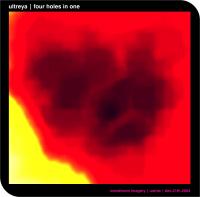
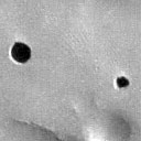
Posted by: ustrax Mar 19 2007, 03:20 PM
I've applied the same accurate technique I did with Ultreya...
And the results don't leave me very optimistic...
The image obtained is quite similar to some of Ultreya, there, where I thought were in depth features, is as we know, a dune field, a beautiful one, but a dune field...
Just see it for the positive side, if I was wrong once I can be wrong twice...

Possible cave
|
Ultreya "abyss"
|
Posted by: djellison Mar 19 2007, 03:45 PM
If you've taken the cave 'targets' from Themis toward the IR, remember that IR imaging is quite different to VIS imaging and you might see quite strange and odd results. IR imaging at night doesn't show the topography too well and is more about the thermal inertia of the target.
Doug
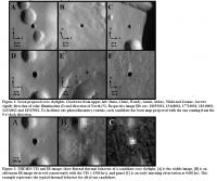
Posted by: elakdawalla Mar 19 2007, 03:54 PM
No, those pictures are indeed VIS. Here's the full figure from the abstract, which also includes daytime and nighttime IR.
|
These are really cool. I can't wait for HiRISE versions.
--Emily
Posted by: djellison Mar 19 2007, 04:05 PM
That'll teach me to comment without digging first
Some nice Lat-Long info from these...
Dena
http://themis-data.asu.edu/img/V18053001
http://themis-data.asu.edu/glossary.html#ctr_lat-6.084 N http://themis-data.asu.edu/glossary.html#ctr_lon239.061 E
Chloe
http://themis-data.asu.edu/img/V13448001
http://themis-data.asu.edu/glossary.html#ctr_lat-4.926 N http://themis-data.asu.edu/glossary.html#ctr_lon239.193 E
Wendy
http://themis-data.asu.edu/img/V17716001
http://themis-data.asu.edu/glossary.html#ctr_lat-8.099 N http://themis-data.asu.edu/glossary.html#ctr_lon240.242 E
Annie
http://themis-data.asu.edu/img/V18340001
http://themis-data.asu.edu/glossary.html#ctr_lat-6.267 N http://themis-data.asu.edu/glossary.html#ctr_lon240.005 E
Abbey & Nikki
http://themis-data.asu.edu/img/V14334002
http://themis-data.asu.edu/glossary.html#ctr_lat-8.498 N http://themis-data.asu.edu/glossary.html#ctr_lon240.349 E
Jeanne
http://themis-data.asu.edu/img/V18315002
http://themis-data.asu.edu/glossary.html#ctr_lat-5.636 N http://themis-data.asu.edu/glossary.html#ctr_lon241.259 E
I can't find any MOC's to match so far - and I'm sure if there were some, they'd be in the abstract.
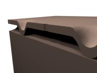
I'm just guessing here - on the possible structure w.r.t. the collapsed lava tubes - and this is possibly the worst 3d visualisation of all time - BUT - perhaps it's something a bit like that ( just not crap )
Doug
|

Posted by: babakm Mar 19 2007, 05:01 PM
Doug,
I'm not sure you have the names matched to the right image as the caption in the abstract says the names are listed clockwise, not according to the alphabetical label (which would've been more intuitive).
I looked for them in the HRSC archive through the http://www.rssd.esa.int/index.php?project=PSA&page=MarsExpress (I'm at work) and found four in H0979_0000_ND3.IMG, Chloe in H1904_0000_ND3.IMG and Jeanne/Annie in H0968_0000_ND3.IMG.
Unfortunately, I don't have access to Gimp here in the office so I couldn't view the images at full res and/or crop for display on the forum.
Posted by: djellison Mar 19 2007, 05:07 PM
I just listed the names in the order they were, and the image numbers in the order they were - ABCFED (with E having two caves and thus two names )
Screw H1904 - that's 1 Gig+....but I've got the other two HRSC obs on the way down.
Doug
Posted by: babakm Mar 19 2007, 05:17 PM
H1904 is a pretty dark image anyway.
BTW, Dena is visible at the bottom of the Chloe THEMIS image as well.
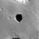
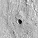
Posted by: ustrax Mar 19 2007, 05:20 PM
So...this must be Clöhe and Jeanne, right?
About Jeanne I don't know but Clöhe looks like even less of an abyss than my previous image...

|
Posted by: tty Mar 19 2007, 06:40 PM
No Doug, that is not the way holes in lava tubes work. They are actual holes in the roof of the tube, and they do indeed often look rather like the ones in the pictures. Have a look at this for example:
http://www.hawaiiweb.com/kauai/html/sites/waikapalae_wet_cave.html
I happen to know a bit about the subject, being interested in paleontology. Normally lava caves are rather dismal places paleontologically since the acid and often wet environment is very bad for bone preservation. However these holes in the roof are very effective pitfall traps and the talus cone that accumulates below the hole can be very good for fossils.
Posted by: djellison Mar 19 2007, 06:41 PM
I know - the still I did is sort of an X-Section along the tube.
Doug
Posted by: djellison Mar 19 2007, 08:05 PM
Pulled out what I can find from the HRSC images....one could, if feeling hatefull towards ones ISP - get some of the stereo pairs and have a go, but I don't think you would learn much.
Doug

Posted by: hendric Mar 19 2007, 09:28 PM
I guess this is a pretty stupid question, but why are they so round? I would expect a tube collapse to be sinuous, or at least oval.
Posted by: tty Mar 19 2007, 10:03 PM
Perhaps impactors punched holes in the roof? Even small secondaries would probably have power enough to do that.
Posted by: babakm Mar 19 2007, 10:18 PM
They look transposed vs the original images, but on another note, is there any value in stacking them? There are three images of Dena and two of the others to work with.
Posted by: ngunn Mar 20 2007, 02:50 PM
This would be how the collapse starts. For the final stage see the natural bridge in Tartarus Colles:
http://www3.telus.net/paulanderson/bridge_PSP0014202045.jpg
Note the roughly semicircular edges either side of the bridge.
Posted by: jaredGalen May 24 2007, 01:01 AM
Is there any radar coverage of any of these areas or would this become an interesting candidate? Or is the radar sensitive enough at 100m depth?
Seems from the discussions here that a lava tube type collapse is most likely so perhaps there is no need for radar coverage. still just wondering.
Posted by: PhilCo126 Jun 6 2007, 08:51 PM
APD :
http://apod.nasa.gov/apod/ap070528.html

Powered by Invision Power Board (http://www.invisionboard.com)
© Invision Power Services (http://www.invisionpower.com)