Printable Version of Topic
Click here to view this topic in its original format
Unmanned Spaceflight.com _ Mars _ Google Mars 3d (With HiRISE!)
Posted by: jekbradbury Feb 2 2009, 08:51 PM
Download: http://earth.google.com
An early overview is available http://www.ogleearth.com/2009/02/google_earth_5_1.html.
This is exactly what I've been waiting for ever since Google Earth came out five years ago. And HiRISE integration is amazing.
Posted by: djellison Feb 2 2009, 09:17 PM
Holy cow - that's amazing...it's what we've ALL been waiting for I think.
Posted by: Tesheiner Feb 2 2009, 09:42 PM
OMG!!!
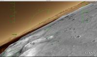
Type "Victoria Crater" on the search box and enjoy!
Posted by: OWW Feb 2 2009, 10:01 PM
WOW!!! Zoomable CTX images! Finally. 
You're right Doug, if this is not what you've been waiting for, you're either mad or crazy, or both.
Posted by: hendric Feb 2 2009, 10:26 PM
Select one of the photos from a lander, and then hit "Fly into this Hi Resolution Photo"

Posted by: Geert Feb 3 2009, 03:48 AM

This is GREAT!
Indeed, this is what I've been waiting for, this opens whole new options and possibility's... mind-boggling. Keeping track of the rover, posting images, exchanging positions, etc, etc, it can all be integrated in this. Plus I wouldn't be surprised if we can develop more enhancements (for instance options to integrate with other sensors, etc, etc) ourselves as add-on's...
Now make the same for the moon as soon as LRO is in orbit, and then continue with all the other planets and moons, looking at the basic setup it seems that that's indeed the idea...
Posted by: helvick Feb 3 2009, 05:40 AM
I just love the way they have a little MER model at the end of the rover tracks.
Posted by: CosmicRocker Feb 3 2009, 06:24 AM
Many, many thanks for discovering and posting this, jekbradbury.
I must imagine this will become a very useful tool for us. It's nice to zoom out to a regional level and check out the green backpacker icons that link to excerpts from "A Traveler's Guide to Mars."
I'm a bit disappointed to find that only some of the HiRise imagery seems to included, but nevertheless, the new software delivers a rich Martian experience to me. I'd have to give it a "thumbs up" as I look forward to where it goes from here.
Posted by: HughFromAlice Feb 3 2009, 11:31 AM
Thanks - Great. Luckily I had a bit of spare time tonight - because I used it all up!!!
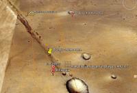
Maps look like they are up to date for the rover positions.
Posted by: Tesheiner Feb 3 2009, 12:03 PM
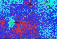
Opportunity map covers the route up to Santorini.
I know that google earth has the option to add "home-made" layers to it ("KML" files); actually I used that feature to map some mountain-bike routes which I logged with a GPS.
<Mmm, just wondering how to translate the rover's route data I have to google earth format...>
Posted by: charborob Feb 3 2009, 02:26 PM
Just took a few minutes to test this thing. Amazing! Can't wait to have some free time on my hands. Have you tried the flight simulator on Mars?
Posted by: neo56 Feb 3 2009, 09:48 PM
I achieved one of my dream : flying in Noctis Labyrinthus, losing myself inside the meanders of the canyon 
Posted by: lyford Feb 4 2009, 02:04 AM
It seems my Placemarks have survived the interplanetary journey.... or else there is a Wild Animal Park near the Cynae Fossae region! And my house appears to be in a crater chain or collapsed lava tube - how cool is that! 
|
Very neat - though it is acting like a Beta on my MacBook for sure - or is the Mars Curse affecting me now as well?
Posted by: Phil Stooke Feb 4 2009, 02:33 AM
Well, it's been great mixing with all you nice people on UMSF, but I'm afraid I'm going to stop posting now - and teaching, writing books, eating, you name it. I'm just going to play with Google Mars until the emergency services break the door down and find a dried-up husk in front of the computer.
Phil
Posted by: Ant103 Feb 4 2009, 11:02 AM
Hi,
A lot of time without posting here, because of some various problems :/
I discover this post, downloaded this new version of Google Earth, and it's totally amazing  I've been waiting for this during a long time, as many of you. Views from Valles Marineris ridges are astounding, I never feel a sensation of gigantism of Valles Marineris like this!
And hurray, I can load my Phoenix KML EDL into Google Mars, it's better than North of Canada  .
.
Posted by: Mogster Feb 4 2009, 09:45 PM
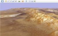
This is amazing. With the terrain mesh detail and aniso filtering applied in the options the detail is very good, its almost like being there.
Just tried the lighting options Sets the correct lighting on the landscape as of now, its sunset from the floor of the Valles Marineris
Posted by: dvandorn Feb 5 2009, 03:56 AM
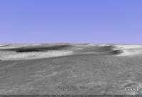
I was impressed by the very accurate 3d renderings of locations where they have been able to interpolate good terrain models. For example, I was able to see, with a very high degree of accuracy, what Victoria looks like from on top of the Soup Dragon...
-the other Doug
Posted by: lyford Feb 5 2009, 04:41 AM
I love it! But is there anyway to get rid of that blue sky on mars?
And it has crashed my mac occasionally loading a MOC image...
Posted by: eoincampbell Feb 5 2009, 07:48 AM
This IS the answer to those IAS Viewer problems on my PPC Mac (never resolved),
I can't remember if Google Earth was around when MRO launched, they've come a long way...
Posted by: djellison Feb 5 2009, 10:48 AM
That's the USGS HiRISE DEM work. It's amazing.
Posted by: CosmicRocker Feb 6 2009, 05:08 AM
Posted by: lyford Feb 6 2009, 05:35 AM
Huh - I must have the uncalibrated version!
|
Melas Chasma, Blue Sky Edition
Posted by: lyford Feb 6 2009, 05:41 AM
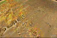
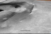
Forget the view from the top, here's from the middle of the Victoria Crater in the dunes looking up!
|
There is elevation data for the individual ripples!!!!
Also, I turned of the atmosphere so I wouldn't be distracted by the blueness. There has to be a setting that I am missing somewheres.
Posted by: imipak Feb 6 2009, 03:31 PM
That would have made an interesting first post-landing image...
Posted by: Juramike Feb 6 2009, 03:34 PM
(...and possibly for the entire mission.)
Posted by: aldo12xu Feb 6 2009, 04:27 PM
Wow, this is amazing! I was flying over the Columbia Hills, Endurance and Victoria for a couple of hours last night.
I'm a newbie to Google Earth......how do I turn off the place names and all those red lines (image boundaries?)? I want to see nothing but the Martian terrain.
Posted by: jamescanvin Feb 6 2009, 04:40 PM
Bottom left there is a window called Layers where you can tick/untick various boxes to turn those things on/off. Turn them all off apart from Terrain (the bottom one) for the true Mars
Just realized that you can have outlines of lots (all?) HiRISE, CTX, MOC, HRSC and CRISM images with links to the image page on the web, by turning on the layers.
|
Posted by: jamescanvin Feb 6 2009, 04:55 PM
And for those that might not have realized, the flight simulator works on Mars as well!
I've just been annoying Spirit, by buzzing her in my F16.
If you don't know about it, there is a fully functioning Flight Simulator built into Google Earth as an 'easter egg' - press Ctrl + Alt + A ( Cmd + Option + A on the Mac) to enter (after you've done it once a menu item appears under Tools). Have fun.
http://earth.google.com/userguide/v5/ug_flightsim.html
|
Posted by: aldo12xu Feb 6 2009, 05:03 PM
Man, oh, man, this keeps getting better and better!! Can't wait to get home to try it out. Thanks James!
Posted by: lyford Feb 6 2009, 06:27 PM
Am I the only one on UMSF with the Blue Sky Bug? I am on a Macbook running 10.5
Posted by: jamescanvin Feb 6 2009, 07:05 PM
My screen-shots above were made on a Mac. (fully up to date OSX)
Not sure what your problem could be on your MacBook, bug with the integrated graphics maybe? (I have a iMac with dedicated graphics)
Posted by: eoincampbell Feb 6 2009, 07:35 PM
I too have the blue sky using a G5 PowerMac 10.4.11.
Posted by: Del Palmer Feb 6 2009, 09:18 PM
The blue sky issue appears to be a graphics card limitation:
http://www.google.com/support/forum/p/earth/thread?tid=51133006e049a144&fid=51133006e049a1440004620eeabda94c&hl=en
Posted by: Ant103 Feb 7 2009, 06:25 PM
No trouble of blue sky for me. I'm running Mac OS 10.5.6 on a Macbook Pro.
Posted by: lyford Feb 7 2009, 07:37 PM
Curse you MacBookPro! You have a better graphics chip than I....
I think there is a UMSF upgrade cycle at work here: I need a bigger HD for the images, a better graphics card, faster internet connections. It's a racket! Doug should get a commission.
Posted by: djellison Feb 7 2009, 07:38 PM
I need it. Just got a new Macbook myself - 2.4ghz, 4gb Ram, 500gb HDD
Posted by: SFJCody Feb 7 2009, 08:06 PM
My Radeon 4870 is really showing its worth. I knew I would need it for something more than Fallout 3!
Posted by: nprev Feb 7 2009, 09:09 PM
I'm not even gonna try downloading it till I get a better machine. My vintage 2003 Dells just aren't up to it.
After lo these many years, I might actually join the Mac crowd! My stepdaughter just visited & she brought her brand-new superthin Powerbook (?); sweet little machine that ran rings around my stuff, I am envious.
Posted by: DarthVader Feb 7 2009, 10:03 PM
After lo these many years, I might actually join the Mac crowd! My stepdaughter just visited & she brought her brand-new superthin Powerbook (?); sweet little machine that ran rings around my stuff, I am envious.
Superthin Powerbook? Maybe She's got a MacBook Air? The Powerbook aren't really sprint chicken anymore ;-)
Posted by: nprev Feb 7 2009, 10:05 PM
Yeah, that's it; afraid I'm not up on Mac terminology. Really cool little computer, though.
Posted by: mhoward Feb 7 2009, 11:09 PM
Not to go totally OT, but I've got a MacBook Air, and I'd rather have one of the refreshed PowerBooks that came out recently. They look nice.
Posted by: djellison Feb 10 2009, 04:09 PM
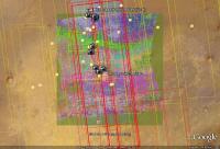
Does anyone know how to load other CTX images / HiRISE images into the landscapethe ones where you see the little orange (or red) square, but clicking on it gives you only the footprint, not the image?
And, is it possible to keep HiRISE images as the top layer so theyre not covered up by lower-resolution CTX images?
Posted by: jamescanvin Feb 10 2009, 07:30 PM
Here is a first draft of a Google Mars file with links to all the Opportunity images I have created over the years.
http://www.nivnac.co.uk/mer/Martian_Vistas_Opportunity.kml
You need to have Google Earth open and in 'Mars mode' else the links will be in the Atlantic. 
Click on an icon to bring up a thumbnail image then click on image to open the relevant entry on my site in a browser.
|
Comments, corrections welcome...
James
Posted by: Astro0 Feb 11 2009, 12:52 AM
James that's excellent!
I'm wondering if it would be possible for other contributing image processors on UMSF to do the same?
Is it possible to have a simple set of intructions available here on how to do this?
I'm going to start using James' image database with Google Mars in some of my outreach classes.
Kids will love the interaction!
Astro0
Posted by: jekbradbury Feb 11 2009, 01:31 AM
You could go one step further and implement them as http://code.google.com/apis/kml/documentation/photos.html, just like the official ones (with the floating cylinders)
Posted by: Poolio Feb 11 2009, 05:36 PM
Newbie here. I usually just hover around these forums like a ghost, but I thought I'd share some of the stuff I've figured out about Google Mars.
I was trying to get the waypoints to work so that the label appeared only when you hovered over the icon, like in the "official" waypoints that take us through conjunction. It turns out that this is not permitted by the UI, but I dove into the XML and was able to figure it out. Basically you need to define a "styleMap" the contains two styles, keyed on "normal" and "highlight", and then set the placemark's "styleUrl" element to the map instead of the style. The key is that the "scale" should be zero for the "normal" style, and non-zero for the highlighted. Note that the "description" tag is necessary for the hover event to fire (and the label to show).
The attached file demonstrates this. It is a seamless extension of the Opportunity route map provided in Google Mars and picks up where that one leaves off. It includes the traverse path, waypoints, and local place names in the same format and structure that has already been established, updated through Sol 1795. oppy_traverse_2009.kml ( 6.37K )
: 658
oppy_traverse_2009.kml ( 6.37K )
: 658
It's actually pretty simple, but it will probably require that further updates be made in the XML instead of the application UI. Hopefully Google will surface style maps in a future release of the product.
There's a pretty decent reference guide to the KML syntax here:
http://code.google.com/apis/kml/documentation/kmlreference.html
Poolio
Posted by: djellison Feb 11 2009, 06:32 PM
You should check into the Opportunity Route Map thread where Tesheiner is doing the same sort of KML thing.
Posted by: Tesheiner Feb 11 2009, 08:35 PM
I saw those "normal/highlight" styles being used on the official route and other KMLs but thought it was better to "keep it simple" at least on my first version of route map in KML. It's not that bad, given that GE automatically hides some sol numbers if the user is looking to a wide area so they are not overlapped.
Posted by: Poolio Feb 11 2009, 10:38 PM
Good idea, keeping it simple. I can't imagine being on the hook to do something like this every couple of days. On the other hand, I couldn't imagine not coming here every day to track the rovers' progress. I seem have zero capacity to make sense of the daily navcam images.
Anyway, it was a pain, sifting through all that XML trying to figure out what was important and what wasn't. Took me hours. A great deal of trial and error. That's why I wanted to put this out there, hopefully to save someone else the tedium. It's quite an amazing tool; I'm looking forward to seeing what other people can do with it.
Posted by: Tesheiner Feb 12 2009, 09:29 AM
I had my share of "hours of trial and error" too some time ago. I was trying to plot on GE some mountain-bike tours logged with a small GPS/datalogger but the format converter (csv to kml) which came with the little gizmo was producing some "unexpected" results so I attempted to directly modify the KML file content.
Thanks for the info re. normal/highlight modes. It IS useful, no doubt at all.
Posted by: algorimancer Feb 12 2009, 03:42 PM
It's particularly nice navigating with a Spaceball (or Space Navigator) controller, though I had to play with the settings a bit to get it to respond well (the default settings aren't very good). It would be really nice if it would do stereo rendering, both as side-by side as well as supporting Stereographics frame switching. Perhaps someday. The available HiRise imagery seems unfortunately sparse.
Posted by: MouseOnMars Feb 12 2009, 04:19 PM
I can remember struggling away with putting together some 3D views of Mars terrain a few years ago. So to have the entire Mars terrain in 3D makes me feel very spoilt !
Posted by: The Singing Badger Feb 12 2009, 09:20 PM
In case any readers haven't noticed, Google Mars also has a 'flight simulator mode', where you can fly a jet fighter or a prop plane over the surface. It's kinda fun to fly over Noctis Labyrinthus.
It's in the 'Tools' menu.
Posted by: jumpjack Feb 26 2009, 10:43 AM
Did anybody verify if distance measurement tool is working properly in GoogleMars?
Also, having a "comparison image" overlayed somewhere to get an idea of how big are Mars features would be cool, but it can't be done if we don't know if the measurment tool gives right results.
Posted by: RoverDriver Feb 26 2009, 12:05 PM
I spot checked on Meridiani where we drove the rover and the distances seem to match the visible features. This only validates the correlation between HiRISE and surface imaging and tracks. I have no idea relative to areas where there is no HiRISE data. I would be surprsed if there were large errors.
Paolo
Posted by: jumpjack Feb 26 2009, 01:22 PM
I was not talking about images size, but about the "ruler" tool of GoogleEarth: if I drag it for 100 meters on Mars... are they ACTUALLY 100 meters, or just 60 (or whatelse, can't remember Mars radius...)
Posted by: djellison Feb 26 2009, 02:06 PM
Nor is Paolo - he's talking about the ruler tool. And - as far as measuring where there is HiRISE imagery to corroborate the measurements - they're accurate - so, one can infer - it's accurate over the whole planet.
Posted by: jumpjack Feb 26 2009, 02:20 PM
full inline quote removed - ADMIN
sorry, my fault.
thanks.
Posted by: Xerxes Feb 26 2009, 07:30 PM
Re: the ruler tool
If you take the pole-to-pole distance using the ruler, you find Earth's hemicircumference to be about 19.5 Mm and Mars's to be about 10.5 Mm. So it looks like they do take it into account. (If you try this yourself, note that the distance will not update when you switch from Earth to Mars, so you have to nudge the endpoints a bit to get it to recalculate.)
Posted by: RoverDriver Feb 26 2009, 11:00 PM
Just to confirm, ys I was measuring with the ruler tool on Hirise images as projected by GE (Mars). As far as inferring that this is correct over the entire surface, I would not be so certain. I'm sure they did the best they could but I would not be surprised if there were some areas where they had stitching problems and therefore locally the ruler might be giving a different value than the truth. But for our simple observations and measurements I think it is quite a remarkable tool. Quite impressive.
Paolo
Posted by: Geert Apr 19 2009, 02:08 PM
It's still a bit experimental, but below kml should give a 'drivability map' (12 mtr grid variance) on Google Mars for the whole area from Endurance down to Endeavour at 2 mtr resolution (you can zoom down lower but then you might get small offset errors).
Light green is best, green is good, blue is 'be careful', red is potentially hazardous (settings are a bit on the 'safe' side so there are many 'fals alarms' but those area's can only be judged at ground level).
It still takes a bit of time to load (and I hope my webserver survives), next version I will add more levels to make it load faster. On the area's where Google Mars does not give HiRise coverage there is a slight offset, I won't be so pretentious to say that this is due to Google Mars but they seem to be using some kind of projection for those area's which not completely matches my own.
Next versions of this I will post in the 'Google Mars' thread so as not to clutter up this thread
Remember you need to open Google Mars first before opening the kml, otherwise it opens somewhere on earth and weird things might happen. After opening the kml you need to go to Victoria crater to see the map.
Regards,
Geert.
HR___MOC_Variance_Drivability_Map.kml ( 562bytes )
: 494
EDIT: UPDATED AND FASTER VERSION UPLOADED ON 20/04
Posted by: Tesheiner Apr 19 2009, 02:33 PM
Too "heavy" for my computer/bandwith. 
I did this sort of experiment before but loading from a local image previously downloaded from an external server. In know there are some sort of kml keywords to limit the access to the referred pictures only if the "zoom factor" is high enough and avoid this problem but I don't remember them by memory.
I'll try tomorrow from a different machine/place.
Posted by: Geert Apr 20 2009, 11:35 AM
I have uploaded an updated version in previous message which has more layers and should load a lot faster although it is slightly less resolution.
Posted by: Tesheiner Apr 20 2009, 01:42 PM
It worked!
I first thought it didn't but then after reading again your original post "After opening the kml you need to go to Victoria crater to see the map." I found it right there. One suggestion: there is a KML keyword to automatically focus on the map after opening it so no need to do it manually.
-------------------
Moved the posts to the "Google Mars" thread.
Posted by: Geert Apr 20 2009, 10:05 PM
Below a first draft of Endeavour crater in Hires for Google Mars.
Start Google Mars first, then open the file. If it doesn't automatically take you to Endeavour after opening, then move to Endeavour and zoom in to see.
Endeavour_crater_combined_view.kml ( 559bytes )
: 402
There is still a slight offset with the Google Mars background, I'll see if I can fix that later this week.
|
|
Posted by: Geert Apr 22 2009, 06:08 AM
In order to improve resolution without slowing down the application too much I have divided the earlier 'drivebility' map in three parts:
Endurance crater to Victoria crater:
Endurance_Victoria_Drivability_Map.kml ( 580bytes )
: 491
Victoria crater to Mini Endurance:
Victoria_Mini_Endarance_Drivability.kml ( 574bytes )
: 362
Mini Endurance to Endeavour:
Mini_Endurance_Endeavour_Drivability.kml ( 584bytes )
: 368
People who downloaded the earlier version don't need to do anything as it will upgrade automatically.
|
This new map has a resolution of aprox 1.7 mtr/pixel, it is no use going up any further as that's way outside the scope of the calculations.
'Red' should be seen as 'potentially' dangerous, however the settings are a bit on the safe side ('better safe then sorry'), only way to judge the real danger is with the eyes of the rover down on the surface. Basically dunes which are converging/merging are seen as a threat and marked red.
Posted by: Geert Apr 22 2009, 06:19 AM
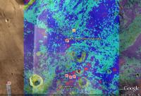
First draft of a map of mineral composition of Victoria area as measured by CRISM.
|
CRISM_Victoria_Mineral_Composition.kml ( 584bytes )
: 385This map is based on measured quantities and distribution of Oxidized iron minerals (ferric minerals, coatings, and iron minerals). Due to the lower resolution of CRISM the number of zoom-levels is somewhat less then the other maps.
In this version there is still a slight offset in longitude, I'll correct that later this week but it will upgrade automatically (the kml is only a link to server based files, makes life a lot easier).
Posted by: lyford Apr 23 2009, 04:38 AM
I am glad this tool is driving creativity!
Posted by: Geert Apr 24 2009, 12:17 PM
|
Map of difference between THEMIS Day and Night IR measurements for Meridiani area
THEMIS_Thermal_Inertia.kml ( 545bytes )
: 416Theorie is that lose sand/dust will show up bright in Daytime IR and dark in Night time IR, so a large difference between daytime and night time IR measurements will show a larger risk of lose sand (I hope).
Map shows least difference in measurements as lightgreen, then onwards to blue, and red is shown as the highest difference (you can't call it a 'no go' area for there is no data on which value's are actually dangerous). Presently Oppy is almost through the 'red' area and should get on 'firmer' ground soon if this map is correct ;-).
Note resolution of THEMIS is only down to aprox. 100 meter/pixel so don't expect data on each individual dune ;-).
Posted by: atomoid May 23 2009, 08:06 PM
Can anyone else had the problem of a grid of red 'X' boxes that are obfuscating most of the landing site and endeavor crater in the Google Earth(mars) regardless of whether or not i load the .kml file ?? it looks like google mars is trying to load data (as the boxes transition from loading symbol to an 'X'). so far i havent had any luck searching on this topic.
Posted by: Reckless May 23 2009, 08:56 PM
Atomoid
In google mars go to the side panel and scroll down the places section and untick the HR plus MOC variance also you can untick the Crism Victoria box if you wish to remove the mineral colours.
At least this worked for me
Hope this helps
Roy F
Posted by: Astro0 May 29 2009, 10:40 AM
This looks like an interesting http://asunews.asu.edu/20090528_marsphoto for Google Mars!
From Arizona SU News: "The first of the new features lets anyone, anywhere, recommend places on Mars to photograph with ASU's THEMIS camera on NASA's Mars Odyssey orbiter. The second new feature shows the most recent infrared images of Mars sent back to Earth from the THEMIS camera."
Cool.
Posted by: Stu Mar 14 2010, 07:10 AM
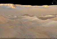
Just been pottering away on Google Mars for a while, wandering around some of my favourite places, including what's probably my fave crater on Mars, which I'm sure you all recognise from this view...
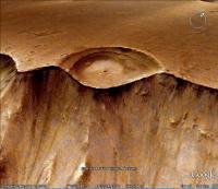
|
... but when you take a look at the bigger picture - wow! Talk about "Landslide Alley"!
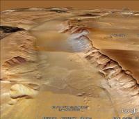
|
Hands up who loves Google Mars..?
Posted by: Stu Mar 14 2010, 08:21 PM
Blog post on "Landslide Alley"...
http://cumbriansky.wordpress.com/2010/03/14/welcome-to-mars-landslide-alley
Posted by: tharrison Mar 14 2010, 10:13 PM
|
|
Wow, looks so cool from that perspective!
Posted by: Antdoghalo Mar 16 2010, 01:59 AM
I hope Google includes the MOC,CTX and HIRISE images in the next release!
That way i can resume my search for volcanoes on the red planet  !
!
Good thing theres a lot of user discoveries, overlays, databases, and info at Google Earth Community!
Posted by: Nirgal Mar 18 2010, 02:14 PM
Does anyone know exactly how Googe Mars does obtain their Digital Terrain Models (DTM) used to render those views ?
It was my understanding that they use the MOLA base map (200-meter-ish post spacing) plus HRSC (Mars Express) DEMs (~50 m resolution) where available and only then draping CTX/HiRISE images etc. over them.
HOWEVER: The impression from views like that of the "half crater" and "landslide-alley" posted by Stu above is that the actual terrain models must be considerably more accurate than MOLA alone.
But yet there does not seem any other altimetry data of that region (i.e. HRSC or HiRISE DTMs) The only related data is CTX imagery but that is 2D-only, i.e. can be draped over the terrain)
So are we seeing still officially unreleased HRSC DTM data, or am I missing some other sources ?
A related question: is there a way to view/save the data in Google Mars as a height map, i.e. similar to what is displayed in the "google maps" like window at the bottom of each HiRISE observation page (i.e. http://hirise.lpl.arizona.edu/ESP_016354_1745 ?
Posted by: Nirgal Mar 19 2010, 07:41 PM
...
So are we seeing still officially unreleased HRSC DTM data, or am I missing some other sources ?
Now I can anser the first of my questions myself: I simply did not zoom out far enough to see the huge green stripes that indicate the MEX/HRSC coverage when enabled in the "Spacecraft Imagery" checkbox
Those HRSC stripes are so large that they are simply not visible at finer scales ... zooming out one can see that really about 50% of the surface must have been coverd by HRSC already ... very impressive !!
The following question remains. Anyone able to get the Google Mars view as height values rather than 3D shaded perspective ?
Posted by: ArMaP Mar 19 2010, 09:43 PM
I don't understand what you mean, are you asking about something like this?
http://img714.imageshack.us/i/marte200.jpg/
Posted by: Nirgal Mar 19 2010, 10:26 PM
That's not quite what I'm looking for: this view does not only contain the color coded height values but there is an additional relief shading applied and mixed with the color coded height. While this is convenient for viewing it is hard to extract the original height data (i.e the DEM) from it. Plus, the color coded height view seems to be available at the coarsest (MOLA) resolution only. The much more detailed HRSC 3D data is not displayed or downloadable in this manner although it must be used by the Google Mars engine internally for the perspective view display.
However, as I have found out in the mean time, there is a direct link provided to the original PDS data record of the HRSC observations that can be used to download and process the original imagery and DTM data
Posted by: Stu Mar 19 2010, 10:33 PM
Then get off UMSF, get onto your computer and start rendering awesome 3D views of Landslide Alley...!!
Powered by Invision Power Board (http://www.invisionboard.com)
© Invision Power Services (http://www.invisionpower.com)