Printable Version of Topic
Click here to view this topic in its original format
Unmanned Spaceflight.com _ Image Processing Techniques _ Map Features Overlays on a Cylindrical Projection
Posted by: scalbers Jan 28 2012, 07:25 PM
Greetings,
Thought I'd mention I'm starting a mini-project to make map feature overlays for planets and satellites. These are set up on a cylindrical projection so they can be displayed with Science On A Sphere, Celestia, and the like. The key is that text for feature names has to be "pre-distorted" so it looks correct when viewed on a sphere. This is especially important at high latitudes. The overlays are for now in the form of transparent PNG images.
So far I've started with Mars and Enceladus. The programming language is IDL, and the lat/lon info for the feature names is from the USGS Map-A-Planet Gazeteer. I'll try to post some results once they are a little better.
Enceladus is a special case, since the map I had put together is in planetocentric coordinates, and the feature lat/lons are in planetographic. So a conversion of one or the other would need to be done.
Steve
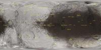
Posted by: scalbers Feb 3 2012, 06:25 PM
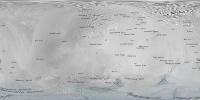
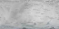
I have now a preliminary map of Mars with the features overlayed onto the texture image. A threshold size of 350km for feature diameter is being applied. A check is made to suppress multiple features that would print on top of one another. Priority is given to "Mons" features and large features.
|
Steve
Posted by: JohnVV Feb 3 2012, 10:49 PM
nice but a question on the location of 180 in the center
why 0 to 360 and not -180 to 180
Posted by: djellison Feb 3 2012, 11:07 PM
That's a debate that's been a part of planetary cartography for a very very long time - and there are cases to be made for both conventions. Neither is right, nor wrong.
The PDS - as this doc states - typically works in 0-360
http://pds.nasa.gov/documents/sr/stdref3.7/Chapter02.pdf
"The PDS recommends that the planetographic longitude standard be followed, but also supports the traditional method. Specifically, the longitude range of (-180, 180) is supported for the Earth, Moon and Sun"
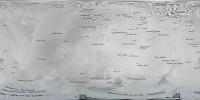
Posted by: scalbers Feb 3 2012, 11:10 PM
John - I had used the 180 center longitude that currently appears in the Science On A Sphere website for Mars, and as Doug mentions a lot of planetary maps are done with the 180 degree center convention. Do I recall that Celestia works better longitude zero in the center?
Accordingly I made some new ones in my web directory with longitude zero in the center.
http://laps.noaa.gov/albers/sos/features/
I also updated the attached image in post #2 with the latest functionality. For example larger features now have a slightly larger font.
That's the latest,
Steve
Posted by: JohnVV Feb 4 2012, 12:40 AM
as djellison pointed out both are right i was just wondering why one over the other
so the particular site "Science On A Sphere " uses that
Posted by: scalbers Feb 4 2012, 12:55 AM
The funny thing is that the quasi-standard way of doing things with SOS is actually longitude 0 in the center. Meanwhile most of the planetary maps on my own site have longitude 180 in the center. So as long as we know what it is we should be OK, particularly if we want to display with Celestia.
Posted by: scalbers Feb 4 2012, 02:22 AM
Meanwhile, here's the latest with Enceladus. The tiger stripes may need some work in terms of rotating the labels.
|
Also looks like the labels are generally shifted a few degrees so the west, so possibly the zero longitude reference system is different between the USGS Gazeteer and my map. This should be possible to adjust.
Posted by: Phil Stooke Feb 4 2012, 03:45 AM
Don't get too hung up on the question of having 0 or 180 in the middle. There is no right or wrong. Sometimes you need to fit a standard required by software, maybe, but think of Earth. Put 0 in the middle, 180 at the edges, and you are splitting the Pacific Ocean in two. If you want to show the Pacific whole, put 180 in the middle. Every application has its own needs. Just do what works.
Doug's PDS quote has nothing to do with the central longitude of a map. It is just saying you can use negative longitudes (up to -180) in those specified cases, but elsewhere longitudes are defined just as 0 to 360.
Phil
Posted by: scalbers Feb 4 2012, 05:09 PM
Here's Enceladus with the longitudes a little closer. An attempt was made to address the tiger stripe label rotations.
|
http://laps.noaa.gov/albers/sos/features
UPDATED: 1941 UTC Feb 4
Posted by: john_s Feb 8 2012, 05:21 PM
The longitude system on Enceladus and the other icy satellites was shifted around 2008- in the case of Enceladus, by about 3.5 degrees. This was because the longitude systems on the satellites are defined relative to geographical features, not relative to the Saturn-facing direction (though the definitions are designed so that zero longitude points approximately at Saturn). By 2008, Cassini mapping of the satellites was complete enough to better determine the locations of the craters used to define the longitude systems, which required shifting the longitude system so that those craters had the "correct" longitudes.
Perhaps this is the reason for the discrepancies in those label positions?
John
Posted by: hendric Feb 9 2012, 09:20 PM
Someone should make a map with 0 Longitude going down the center instead of the equator. At least then we would have correct perspective on the tiger stripes. 
Posted by: scalbers Feb 14 2012, 04:28 PM
Hendric, yes that would be an interesting presentation, basically rotating the data 90 degrees around the X or Y axis when making the cylindrical projection. The labels should look OK if the map in post #10 is so transformed.
Meanwhile, the general intent with these feature maps is to view them with a program such as Celestia, so one can see the features and labels with a proper perspective hovering over the location of choice. In the case of Celestia the tiger stripes and labels have the correct perspective, though the well-known Celestia polar pinch effect shows up here.
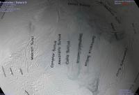
|
Posted by: scalbers Feb 14 2012, 04:33 PM

Perhaps this is the reason for the discrepancies in those label positions?
John
Indeed John, the Enceladus labels in post #10 have a 3.5 degree shift compared with post #8 and that appears to make things somewhat better. I had thought I shifted the underlying map to account for this and I'm guessing the USGS Gazeteer might have the older coordinate system? We might check this by looking at the particular crater(s) that is the reference point.
There are a couple of other considerations as well. First is that I wrote a routine to convert the USGS label data in planetographic coordinates to my map that is in planetocentric. Hopefully that is working correctly. Still there might be on the order of a degree or two of error in the construction of the map. If there remains a source of systematic longitude shift this presents an opportunity to try and correct things.
Steve
Posted by: Phil Stooke Feb 14 2012, 04:37 PM
Re: Post 12.
That is called a Transverse Cylindrical Projection, perhaps most familiar to us in the expression UTM (Universal Transverse Mercator), a coordinate system which maps long narrow strips (gores) 6 degrees wide and 160 degrees long, from 80 north to 80 south, in 60 zones around the planet. Within each zone, you are looking at a cylindrical projection running along the meridian.
So this can be done, and any map reprojection software which allows map data to be output in a transverse cylindrical projection would do it for you.
Phil
Posted by: john_s Feb 14 2012, 05:50 PM
Actually the USGS maps (and presumably, feature coordinates) are really planetocentric, in that the coordinates of features on non-spherical moons are defined by the orientation of the direction to the body center rather than the direction of the local surface normal. The fine print explains that they are "planetographic relative to a spherical surface" or something like that. What they mean by "planetographic" is not that surface normals are used to define coordinates (they aren't), but that west longitudes are used (planetocentric coordinate systems traditionally use east longitudes).
Very confusing- it took me a long time to sort this out myself.
John
Posted by: JohnVV Feb 14 2012, 05:56 PM
no kidding same here , but i still have to look things up .
Posted by: scalbers Feb 14 2012, 06:04 PM
Thanks much for the elucidation. Here is a link that looks to be consistent with this scenario:
http://planetarynames.wr.usgs.gov/TargetCoordinates
And here is the result when I refrain from doing the transformation:
|
Steve
Posted by: scalbers Feb 15 2012, 07:37 PM
Next one - here's what I have so far for Io showing all features larger than 150km:
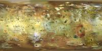
|
Posted by: scalbers Feb 15 2012, 08:47 PM
And here is Europa with features larger than 40km. I'll have to consider whether to rotate the labels for some of the Linea:
|
Posted by: scalbers Feb 15 2012, 09:18 PM
And back at Saturn, here are the Mimas features (all available ones from the USGS Gazeteer):
|
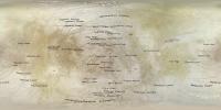
Posted by: scalbers Feb 18 2012, 08:12 PM
Here's Iapetus, with a 5 degree shift that appears to reconcile the image with the IAU convention of the feature longitudes.
|
Other versions can be found here (for Iapetus along with other objects):
http://laps.noaa.gov/albers/sos/features
I just figured out how to select the fonts, so future revisions should have an improved look.
Posted by: Phil Stooke Feb 29 2012, 02:00 PM
A very nice project, Steve - I'm enjoying these maps.
Phil
Posted by: scalbers Aug 18 2015, 11:33 PM
Thanks Phil - now 3 years later, I'm checking now on improving my feature overlay for Vesta. Interesting that the USGS Gazetteer for Vesta seems to have longitudes about 150 degrees off. Claudia is supposed to be on the prime meridian for example, yet is listed as 146 longitude if I'm reading this correctly.
http://planetarynames.wr.usgs.gov/nomenclature/AdvancedSearch
Does anyone know why there is a discrepancy on this?
Posted by: JohnVV Aug 19 2015, 12:10 AM
the mosaics here for Vesta line up almost perfectly with the 3d mesh
http://dawndata.igpp.ucla.edu/tw.jsp?section=data/FC/Maps
but why the USA govt. and the rest of the world differ
0 to 360 and -180 to +180
that is not new
that is however a bit odd ...
Posted by: Bjorn Jonsson Aug 19 2015, 12:12 AM
There are/were several Vesta coordinate systems in use. I don't remember the details but needless to say this can be confusing.
Posted by: elakdawalla Aug 19 2015, 04:24 PM
There are four different coordinate systems in use for Vesta. Some information in http://www.planetary.org/blogs/emily-lakdawalla/2013/09131649-vesta-image-data-browser.html and more http://www.planetary.org/blogs/emily-lakdawalla/2013/09131649-vesta-image-data-browser.html.
Powered by Invision Power Board (http://www.invisionboard.com)
© Invision Power Services (http://www.invisionpower.com)