Printable Version of Topic
Click here to view this topic in its original format
Unmanned Spaceflight.com _ LRO & LCROSS _ LCROSS en route
Posted by: NGC3314 Jul 15 2009, 03:08 PM
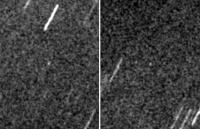
While we're waiting for Those Pictures, here are a couple of shots of LCROSS from our campus observatory last night (0221, 027 UT on 15 July). 4 minute exposures tracking expected motion from the Horizons ephemeris, within 20 degrees of the southern horizon and fighting summertime haze as well as city lights. I wanted to catch it before its inclined orbit takes it too far south, after which it spends a week or so as a predawn object. The range was about 563,000 km, and the Centaur is no bigger than a CSM/LM combination, so this is a more difficult target than spotting an Apollo enroute was. (On the other hand, nobody had CCD imagers in 1969).
|
Posted by: nprev Jul 15 2009, 10:44 PM
Sweet!!!
What's your campus scope, anyhow? (Type, aperature, etc.)
Posted by: NGC3314 Jul 16 2009, 02:52 AM
0.4m Ritchey-Chretien, using one of the big Santa Barbara Instruments CCDs for this. http://www.astr.ua.edu/keel/ua16inch.html. I have been very pleased with its performance (installed about 5 years ago, replacing a vintage-1950 refractor). With our summer climate, I am also very pleased that it can be operated from an air-conditioned control room! Perspiration is bad for the logbook, not to mention keyboard.
Posted by: Lewis007 Aug 10 2009, 07:25 AM
An article on the "cold side bake-out" process (to get rid of water contained in the Centaur stage's foam layer) can be found here: http://www.spaceflightnow.com/lcross/090810bakeout/
Two bakeouts have been completed, with at least one more to go.
The target crater for the impat will be decided upon early September, and NASA tentatively plans to announce the target crater around Sept. 10.
Last week, LCROSS looked back at Earth as part of an calibration of its science payload. More details can be found here: http://www.nasa.gov/mission_pages/LCROSS/main/
|
Posted by: mps Aug 25 2009, 06:43 AM
LCROSS experienced an anomaly: http://www.nasa.gov/mission_pages/LCROSS/main/index.html
Posted by: Zvezdichko Aug 25 2009, 09:46 AM
Oh, this is BAD! But they are optimistic that the mission will be fulfilled despite the problem.
Posted by: nprev Aug 25 2009, 12:39 PM
Wow. Is the IRU in question part of the Centaur itself? That would sort of make sense of such a dramatic fault, since booster components ordinarily aren't expected to operate longer than a few hours at the most.
Posted by: ugordan Aug 25 2009, 01:03 PM
Hmm, I thought star trackers were the de facto method of maintaining/figuring out attitude with gyros only as backups for periods when star trackers are unavailable? 
Posted by: John Moore Aug 25 2009, 05:00 PM
There were some initial problems with the star tracker (STA) and the IRU (June 26) after launch, however, these were minor, expected, problems -- according to the http://wiki.nasa.gov/cm/blog/lcrossfdblog.blog/posts/index.html.
As far as I understand, the ACS Attitude Control System is "based primarily on LRO hardware and software in the same arrangement". Tried finding some images of the IRU, the ACS, however, no luck -- assuming that they are on the LCROSS R4 (Attitude Control & Communications Electornics) panel.
John
http://www.moonposter.ie/
Posted by: Lewis007 Aug 26 2009, 06:41 AM
On August 17, LCROSS took additional images of the moon and earth, as part of the process to calibrate its instruments. See page http://www.nasa.gov/mission_pages/LCROSS/main/index.html
Posted by: Marz Aug 26 2009, 03:27 PM
Here's a Spaceflight article explaining the recent startracking-frenzy anomaly:
http://spaceflightnow.com/lcross/090825fuel/
summary: Half the fuel is gone, but it should be just enough to complete the mission. LCROSS may have to cancel some activities not crucial to the mission to save the fuel for other unexpected contingencies.
Posted by: Astro0 Aug 27 2009, 02:12 AM
In response to the Spaceflight Now article, this response from the LCROSS team...
During a communications session on Aug. 22, it was discovered that a fault had been triggered in the spacecraft's inertial reference unit, or IRU. The IRU is used by the probe's attitude control system to determine its orientation in space.
The fault in the IRU caused LCROSS to switch to its star tracker for attitude information. Noise in the star tracker resulted in the spacecraft's attitude control system firing the spacecraft's thrusters excessively, consuming a substantial amount of propellant.
The mission operations team was able to correct the situation and stop the excessive thruster firing. Mission engineers determined what went wrong and uploaded software updates that should prevent such an incident from recurring.
The big issue was determining how much propellant was lost and how much was required to successfully complete the mission. The good news out of all of this is that the problem was caught and corrected in time so that the spacecraft still maintains a positive propellant margin; we still have more than enough propellant to successfully complete the mission. However, our extra margin of propellant is not nearly as much as it was previously. Mission management and the operations team want to maintain a prudent propellant margin for the rest of the mission and are therefore looking at the schedule of upcoming maneuvers to determine which are really necessary and which we can do without.
The bottom line here is:
1. An anomaly occurred which caused excessive use of propellant on the spacecraft.
2. The anomaly was detected and corrected.
3. Even after the anomaly, we have enough propellant to complete the mission.
4. We are still on target for a October 9 impact at 11:30 UT.
I know we promised you an exciting mission, but we are all looking forward to toning down the excitement until impact!
...End Message.
Posted by: nprev Aug 27 2009, 02:21 AM
Good info, all (thanks for the late-breaking, Astro0!) Yes, by all means, let's save the rest of the excitement for The Day.
Didn't realize that LCROSS' ACS was designed to torque the entire stack around...amazing engineering, and undoubtedly some pretty unique control algorithms at work there.
Posted by: climber Sep 5 2009, 05:33 PM
More good news: http://www.spaceref.com/news/viewsr.html?pid=32291
Posted by: Astro0 Sep 5 2009, 11:37 PM
Nice memo to the LCROSS team and well deserved.
I am sure that they know how much effort the DSN put in also providing continuous coverage for LCROSS.
Also, how other missions made way in the schedule for them.
On UMSF we get to see the pretty pictures and data, but the effort that goes in to getting this stuff for us is incredible.
I've watched our comms teams during spacecraft emergencies and I can tell you it's incredible to watch so many people come together to solve sometimes seemingly unsolvable problems and all in real-time (and even two-way light travel time!).
I'm going to have to write a book one day about all the backroom happenings 
Posted by: climber Sep 6 2009, 11:40 AM

Oh yes, PLEASE do it. This is the kind of stories I'm badly looking forward to read.
I realise that we, in UMSF, are very pleased when a PI is given words in the forum, but YOU are also inside... and on all UM missions!!!
Thanks for your so valuable inputs.
Posted by: stevesliva Sep 6 2009, 11:37 PM
Cassini status reports do a good job of just saying it like it is. It often leaves me befuddled, but this is pretty clear:
Due to ongoing issues with the LCROSS spacecraft, it was requested that Cassini give up the beginning of two DSN tracks on DOY 241 and 243. For DOY 241, DSN schedulers were able to obtain a short DSS-55 track to maintain the full OTM-215 uplink window. On DOY-243, the decision was made - with the concurrence of project management - to accept the science data loss. This will result in approximately 45 MB of data that will not be seen on the ground due to the loss of DSS-65 track time.
...We can see at least one of the actions.
Posted by: Paolo Sep 11 2009, 05:13 PM
Just announced: impact in Cabeus A
Posted by: Hungry4info Sep 11 2009, 05:16 PM
Quick question regarding DSN time between Cassini and LCROSS. Can't Cassini just transmit the data at another time?
Posted by: elakdawalla Sep 11 2009, 05:33 PM
Anybody see any graphics online anywhere? I've looked at NASA, ARC, and LCROSS sites and come up empty.
Posted by: ugordan Sep 11 2009, 05:55 PM
FWIW, http://forum.nasaspaceflight.com/index.php?topic=18535.msg476497#msg476497 over at the NSF.com forum has an image of the "best pre-LRO, Lunar Prospector neutron data" showing the location of the selected site. Unfortunately, I cannot access the referenced paper, maybe others will have more luck.
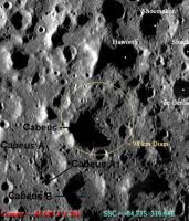
Posted by: John Moore Sep 11 2009, 06:00 PM
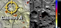
Cabeus A crater location...the impacts should be visible for some of us...WOOT 

|
Image: (Left) Shaded relief map; (Middle and Right) Lunar Orbiter views; (Inset) Cabeus A crater region. North up, West left.
See http://www.nasa.gov/home/hqnews/2009/sep/HQ_09-210_LCROSS_Crater_Selection.htm
-----------------------
John
http://www.moonposter.ie/

|
Posted by: Phil Stooke Sep 11 2009, 09:15 PM
"Quick question regarding DSN time between Cassini and LCROSS. Can't Cassini just transmit the data at another time?"
No, it gets written over by new data. Only the highest priority data is protected from that.
Phil
Posted by: Ron Hobbs Sep 11 2009, 10:33 PM
The above link doesn't work for me; try this one:
http://www.nasa.gov/mission_pages/LCROSS/main/LCROSS_crater.html
There is a labeled telescopic image of the South Pole:
http://www.nasa.gov/images/content/385735main_NMSU_LCROSS_medium-1.jpg
A little thought please - do not put large images straight into a thread - Admin
Posted by: belleraphon1 Sep 11 2009, 11:19 PM
For those who missed the briefing here it is on Youtube
http://www.youtube.com/watch?v=Y9RAWPBoi3I
I had planned to watch it but work got in the way.
Craig
Posted by: eoincampbell Sep 12 2009, 05:56 AM
Thank you for posting that very informative press conference,
my question would be - is the final target permanently shadowed ?
Posted by: PhilCo126 Sep 12 2009, 08:05 AM
For those hoping to see the impact; here're the Moon phases for October 2009:
http://www.moonconnection.com/moon-october-2009.phtml
A cadre of professional astronomers using many of the Earth's most capable observatories is helping maximize the scientific return from the LCROSS impacts. These observatories include the Infrared Telescope Facility and Keck telescope in Hawaii; the Magdalena Ridge and Apache Ridge Observatories in New Mexico and the MMT Observatory in Arizona; the newly refurbished Hubble Space Telescope; and the Lunar Reconnaissance Orbiter, among others.
I'm also looking forward to what images amateur astronomers will come up with. NASA plans a Citizens' science website for those...
Posted by: Tman Sep 13 2009, 03:50 PM
Here a GIF animation of the Moon phase and the visibility/location of Cabeus A for "earthbound" watchers for October 09. Though, timing is bad 
http://greuti.ch/astro/LCROSSimpact.gif
I tried to match http://www.unmannedspaceflight.com/index.php?s=&showtopic=6108&view=findpost&p=146042 as good as possible.
Telescope views: http://groups.google.com/group/lcross_observation/web/finders?hl=en
And wow: http://www.pbase.com/slammel/image/104360794/original
Posted by: Paolo Sep 28 2009, 08:46 PM
Target crater switched from Cabeus A to Cabeus (proper)
http://www.nasa.gov/mission_pages/LCROSS/main/index.html
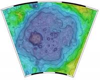
Posted by: John Moore Sep 29 2009, 01:03 PM
I would think that they'll probably aim for the red-boxed region (right) as shown in the image below?
However, as to why Cabeus A was chosen initially is a puzzle as looking at the water equivalent hydrogen image (left), that while Cabeus A (Cabeus A1, really) has a much higher concentration (purple rectangle), its area is very much smaller to those of Cabeus and Cabeus B regions (oranges/reds) where the concentrations are smaller, but likely of successfully hitting them is better, isn't it?
John
------------
http://www.moonposter.ie
|
Posted by: Phil Stooke Sep 29 2009, 01:45 PM
http://www.nasa.gov/pdf/386497main_target-selection_web2.pdf
This link goes to a c. 12 MB PDF on target selection. Page 8 has a map showing a more likely location. May not be exact, but pretty close. (see also p. 19)
Phil
Posted by: John Moore Sep 29 2009, 03:06 PM
Thanks Phil
Page 19 is very useful and probably more relevant, (the yellow dots in p8 are more than likely just ID crater centres).
As this is a Sept 5 publication and the text is still referring to Cabeus A to be the main target (p23 and elsewhere), the target corrections will undouptedly be refined down the closer to impact date.
Whatever one is chosen, however, it's sure to be a good'un
John
Posted by: tanjent Sep 29 2009, 04:34 PM
Note that in the Colaprete report the Earth observability constraint is actually violated by the Cabeus site that is now the preferred target.
In return for a 50% gain in the Pixon signal (listed as criterion #2), they accepted a 125% increase (0.63 to 1.42) in the solar mask (criterion #1) and almost a ninefold
increase (0.33 to 3.07) in the earth observability mask (criterion #3). It's kind of hard to reconcile the ex-ante criteria with the subsequently revealed preference
unless the key lies in page 2 "Data not released to the public by individual Projects and Principal Investigators has been removed." To be accurate, that would have to cover the subsequently discovered data too, of course.
Posted by: Phil Stooke Sep 29 2009, 04:55 PM
The latest release did refer to new topographic data showing better illumination than they had anticipated. The Earth observability mask would be very dependent on the exact location chosen, so a small move could alter it significantly.
I really want a map showing the exact location! Also, this is the Centaur target. The second impact site has not been announced yet. It would be nearby, but Colaprete talked about it at LPSC in March 09, responding to a question from me, saying that it might go to a spot with different illumination conditions, like the edge of a permanent shadow area if the Centaur went deep into the shadow area.
Phil
Posted by: elakdawalla Sep 29 2009, 08:19 PM
Ask and ye shall receive I asked your questions of Tony Colaprete. He replied that he was hoping to get a map released today, and that the LCROSS ship itself would be targeted somewhat (3 km) away from the Centaur site in order to test a different location.
--Emily
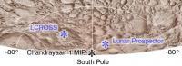
Posted by: Phil Stooke Oct 2 2009, 03:30 PM
Here's a map of the approximate locations of the three polar impacts - LCROSS (counting as one) and MIP and Lunar Prospector. Only approximate as we still don't have actual coordinates for MIP or the LCROSS target.
I have taken the Cabeus area from LOLA data. It's much better shown here than on the current map on the LCROSS website, which appears to show Cabeus with half its real diameter. That older map is derived from an outdated USGS relief drawing.
Phil
|
Posted by: elakdawalla Oct 2 2009, 04:03 PM
What are the coordinates of the different impact sites?
--Emily
Posted by: Tman Oct 2 2009, 04:35 PM
The Google group of LCROSS (amateur) Observation has updated its page too: http://groups.google.com/group/lcross_observation/web/finders
Posted by: Phil Stooke Oct 2 2009, 08:06 PM
From the Observation Group website:
-------------------------
Hello Team!
Latest update on impact locations:
Centaur: -84.70, 310.95E
SSC: -84.77, 310.45E
These are final and should not change.
Nominal timing for impacts:
Centaur = 9 Oct 2009 11:31:30 UTC
SSC = 9 Oct 2009 11:35:45 UTC
There may be some variation from these nominal times through remaining
trajectory correction maneuvering. We will post updates to these times
as they become available. Any timing updates on impact night will be
posted to LCROSS Twitter page, LCROSS Facebook page, and LCROSS-CS.
Brian
----------------------
Final LCROSS Centaur and SSC target coordinates (Lat., Lon. in ME)
Centaur: -84.675, 311.275 E
SSC: -84.729, 310.64 E
Elevations (Assumed Lunar radius: 1737.4 km):
Centaur target elev: -3.82693 km
SSC target elev: -3.80909 km
Impact Times:
Centaur: 9 Oct 2009 11:31:30 UTC
SSC: 9 Oct 2009 11:35:45 UTC
Note: These are nominal impact positions and times. Actual impact
times based on TCM results may differ (see next slide for
uncertainties)
----------------------------
That point is slightly west of the position shown on my map.
Phil
Posted by: John Moore Oct 2 2009, 10:41 PM
Took the latter coords., -- rough idea, therefore, but not exact.
John
|
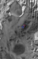
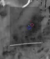
Posted by: Phil Stooke Oct 3 2009, 08:45 PM
Here's the latest info from Tony Colaprete, via the LCROSS Observation Group:
http://lcross.arc.nasa.gov/docs/LCROSS_Target_Update_100209.ppt
LCROSS Observation Group:
http://groups.google.com/group/lcross_observation
And a modified version of his map:
|
"Centaur Impact indicated by Red circle, SSC impact indicated by Blue circle"
The shading is LOLA elevation, not hydrogen abundance.
Phil
Posted by: dmuller Oct 4 2009, 12:53 AM
Centaur = 9 Oct 2009 11:31:30 UTC
SSC = 9 Oct 2009 11:35:45 UTC
Thanks Phil, this is very useful. Updated my http://www.dmuller.net/lcross with that info. Having troubles finding anything of a timeline of upcoming events, or the very latest trajectory info for that matter - the data on the Horizons system has LCROSS going through the moon
 and I could not find any SPICE kernels. Unfortunately I'll be on the road for most of next week and can only "tweak" my existing trajectory data to match predicted impact times, can't process SPICE kernels on the road.
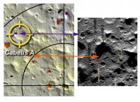
Posted by: John Moore Oct 4 2009, 02:01 PM
That's better!
The recent DIVINER image is proving quite useful to 'see' the area they're aiming at... http://www.moonposter.ie/feature.htm ...looks like it's in a shallow spot of two small merged impact craters.
John
Posted by: Phil Stooke Oct 4 2009, 02:36 PM
This is what I get by overlaying Colaprete's map over Diviner to check the position.
Phil
|
Posted by: John Moore Oct 4 2009, 03:45 PM
Isn't that exact same as in my link above?
John
I don't know - but you inline quoted everything from the previous quote. Stop it. Final warning. Further posts will just be deleted - ADMIN
Posted by: Phil Stooke Oct 4 2009, 03:59 PM
It's the image processing that's different.
Phil
Posted by: centsworth_II Oct 4 2009, 04:59 PM
Here's the map comparison that interests me: The target and http://planetary.org/blog/article/00002093/p:// maps:
The purple pixels in the old target area indicate (possibly) 1.7% water, the orange pixels of the the new target indicate 1%. As I understand it, the lower concentration of water in the new target area is offset by better viewing of the results. I wonder if there was also a little discomfort in relying on a signal of two purple pixels as opposed to a genuine patch of orange.
It seems to me that the new target is at the very edge of the orange patch. Perhaps that's the result of different viewing angles in the two images?
|
Posted by: Phil Stooke Oct 4 2009, 05:07 PM
Also the map of hydrogen concentrations is very model-dependent. The data were low resolution, and a model tries to show where it might be concentrated to give the blurry result actually observed. They will have better data now from LRO and other spacecraft, and that's probably what they preferred to use rather than the older model.
Phil
Posted by: Phil Stooke Oct 4 2009, 05:18 PM
This is a comparison of the points John and I matched. They are very close but not exactly the same. I should point out that Tony Colaprete's circles don't reflect uncertainties. If they did they would not be the same size. The SSC uncertainty is about 3x greater due to the separation burn.
Phil
|
Posted by: JGodbaz Oct 5 2009, 08:10 AM
No, that's not true unfortunately. This document (http://www.nasa.gov/pdf/386497main_target-selection_web2.pdf) shows that the new target crater Caebus has *far* worse viewing conditions than Caebus A.
Caebus A Sun Mask Height: 630m, Caebus A Earth Mask Height: 330m
Caebus Sun Mask Height 1420m, Caebus Earth Mask Height 3070m
This is quite bad news -- they're sacrificing a lot of water sensitivity due to the sunlight/Earth masking. There must have been something seriously wrong with Caebus A to warrant this, as the mask heights at Caebus A are absolutely perfect for an experiment like this. I'm guessing that new LRO data must have either indicated a very uneven distribution or lack of water in the old target.
Posted by: John Moore Oct 5 2009, 11:00 AM
@ Phil...ah yes...see what you mean, your points are certainly more precise -- I think I was more interested in the feature that the points were impacting upon....my apologies.
@ ADMIN....my apologies also to you...I wasn't aware that I was abusing the forum, or, that I had received a previous warning before your 'Final warning' issue. I have tried contributing where I thought necessary interest prevailed -- submitting relevant images and comments (all done with respect), however, it appears I am misguided. Might be better if I just observe from now on.
Regards
John
------------
With great power comes greater responsibility...sometimes
Posted by: Phil Stooke Oct 5 2009, 11:16 AM
John, it's only the 'quote' business that is an issue. When you reply, click on 'add reply' at the bottom of the page instead of the 'quote reply' at the bottom of the specific message.
Phil
(PS I'm not an ADMIN, just offering advice)
Posted by: centsworth_II Oct 5 2009, 03:34 PM
The September 5 paper you link to has been superseded by a http://planetary.org/blog/article/00002125/ Based on new data, there are advantages both in certainty of hydrogen signal and viewing geometry for the new site.
"The general consensus of lunar experts led by the LCROSS science team is that Cabeus shows, with the greatest level of certainty, the highest hydrogen concentrations at the south pole. Further consideration of the most current terrain models... was important in the decision process. The models show a small valley in an otherwise tall Cabeus perimeter ridge, which will allow for sunlight to illuminate the ejecta cloud on Oct. 9, and much sooner than previously estimated for Cabeus. While the ejecta does have to fly to higher elevations to be observed by Earth assets, a shadow cast by a large hill along the Cabeus ridge, provides an excellent, high-contrast, back drop for ejecta and vapor measurements."
Posted by: Phil Stooke Oct 6 2009, 01:16 AM
It's hard to keep these maps up to date! Today's trajectory correction, TCM 9, moved the target 9 km - don't know where yet. See the Flight Director's blog at:
http://wiki.nasa.gov/cm/blog/lcrossfdblog/posts/post_1254770098554.html
Phil
Posted by: JGodbaz Oct 6 2009, 01:31 AM
Thanks, I wasn't aware of the new release.
I wouldn't say that there are any advantages to the viewing geometry over Caebus A though -- even with the valley the Earth mask height is still very poor and they didn't specify the actual sun mask height. It might be better than previous, but without a specific figure it could still be a lot worse than Caebus A and a similar backdrop could have as easily been present at the previous crater (Not trying to be argumentative or anything , it's just hard to distill a lot of information from a normal press release).
Posted by: Phil Stooke Oct 6 2009, 01:37 AM
If it was worse, would they have chosen it? They have far more information than we have.
These are the coords I have now:
Cabeus_impact_Centaur 310.950 -84.770 -3.827 (as of 2009oct03)
Cabeus_impact_SSC 310.450 -84.770 -3.8 (as of 2009oct03)
(values are long, lat, LOLA elevation)
source:
http://groups.google.com/group/lcross_observation/browse_thread/thread/6dcfb743944c607f
Phil
Posted by: JGodbaz Oct 6 2009, 01:42 AM
They don't have a lot of choice as there aren't a lot of good target craters with an adequate concentration of water and the ones with water don't necessarily have the best geometry. I'm not saying they haven't made the best decision possible, just that it doesn't look like an easy trade-off.
Posted by: Phil Stooke Oct 6 2009, 01:47 AM
I think you're right. I bet the site selection process looked like it would be a lot easier when the process started.
Phil
Posted by: PDP8E Oct 6 2009, 03:06 AM
impact is Oct 9, 7:30am-ish local time with the sun up here in Boston....don't think I going to see anything (sun rises at 6:50am).
West Coast Amateurs : you are our only hope!
The LCROSS Centaur impact is scheduled for 4:31 a.m. PDT or 7:31 a.m. EDT (11:31 UTC) on October 9, 2009. The sheparding spacecraft will impact at 4:35 a.m. PDT or 7:35 a.m. EDT (11:35 UTC). Mission scientists estimate that the Centaur impact debris plume should be in view several seconds after Centaur impact and will peak in brightness at 30 to 100 seconds after impact.
Lunar Impact Locations
Centaur: -84.675, 311.275 E
Shepherding spacecraft: -84.729, 310.64 E
Time Zone Lighting Conditions for Viewing
Eastern Daybreak will prevent viewing of the debris plumes.
Central Best viewing is West of the Mississippi River.
Mountain Excellent lighting conditions.
Pacific Excellent lighting conditions.
Alaska Excellent lighting conditions.
Hawaii Excellent lighting conditions.
cheers
Posted by: Phil Stooke Oct 6 2009, 02:36 PM
Ahh, good old Social Media! Lots of entertainment as we await the impact.
The LCROSS Facebook page has been invaded by 'Don't bomb the Moon' types. I can't believe anyone is that stupid, so I am forced to think it's all a joke. They are sitting around laughing at the people who respond seriously, which makes serious responses a waste of time. (Most space hoax stuff is the same, hardly anyone really believes it, especially those at the root of it)
Meanwhile... it's no longer active but there was a very funny - intentionally funny - Fake LCROSS twitter account (you can get to it just by googling 'fake lcross'). Fake LCROSS fretted about his (or her?) impending doom, hoping against hope that the launch would be cancelled due to bad weather or other problems.
Meanwhile, LCROSS proper has been twittering all along, and very well too in my opinion. Very informative posts, good links, and frequent updates. I'm quite impressed with this approach to outreach.
Phil
Posted by: ElkGroveDan Oct 6 2009, 04:12 PM
West Coast Amateurs : you are our only hope!
Well I don't have any decent equipment set up, but I'll put my Canon SLR on a tripod with a 300mm and start firing off the 700 images that fit on the 4G card just prior to the impact and that should take me several minutes down the road, though I seriously doubt anything will be visible at that macro scale. S'pose I could also put my video camera on full zoom which will be similar to the 300mm SLR.
But I'm hoping it will be carried live somewhere. Anyone know if NASA TV has planned a feed of anything useful for that time slot?
Posted by: Marz Oct 6 2009, 05:23 PM
I saw this on the NASA link: a list of public viewing opportunities.
http://www.nasa.gov/mission_pages/LCROSS/impact/event_index.html
NASA TV will also show it:
LCROSS Lunar Impact
7:31 a.m. EDT/4:31 a.m. PDT
Friday Oct. 9
An approximately 1.5 hour Live NASA TV Broadcast is planned for the LCROSS impacts starting at 6:15 a.m. EDT/3:15 a.m. PDT, Oct. 9, on NASA TV and www.nasa.gov/ntv.
The broadcast includes:
Live footage from spacecraft camera Real-time telemetry based animation Views of LCROSS Mission and Science Operations Broadcast commentary with expert guests Prepared video segments Views of the public impact viewing event at NASA Ames Possible live footage from the University of Hawaii, 88-inch telescope on Mauna Kea. The live LCROSS Post-Impact News Conference will be 10 a.m. EDT/7 a.m. PDT on NASA TV and www.nasa.gov/ntv.
It looks like viewing should be good for most of the western USA/Canada. It'll be dark here in Dallas, TX, but right on the edge of dawn... well, with light pollution it's always on the edge of dawn. It'd be nice to head west a bit, like to the party in San Angelo, to get the high contrast sky. I just have a 3.5" Schmidt-Cassi, so I'm torn between trying to watch it live on the web or my toy-scope.
Posted by: MahFL Oct 6 2009, 06:09 PM
"NASA to Bomb the Moon Friday "
Good god......
"....on a mission to fire a missile into the south pole of the moon that is twice the speed of a bullet..."
nice reporting....
http://www.nbcsandiego.com/news/politics/NATL-RRNASA-to-Bomb-the-Moon-Friday-63598462.html
Posted by: centsworth_II Oct 6 2009, 06:30 PM
Good god......
I found the first sentence the most offensive: "NASA's going for full impact Friday, firing a bomb-laden missile at the moon in a dramatic search for water."
"Bomb-laden"!? What truly awful reporting.
Posted by: Stu Oct 6 2009, 09:52 PM
DEFINITELY go watch it! For one thing, if it turns out that the plume WAS visible in a smaller scope, and you missed it cos you didn't even try, you will never forgive yourself. Also, even if you don't see anything you can still look back in years to come and enjoy the fact that you were watching the Moon at the time of the impact, which is quite historic, right? You can watch re-runs of anything picked up by biggers scopes afterwards.
Posted by: nprev Oct 7 2009, 12:05 AM
Okay, I'm convinced. Gonna dust off the ol' NexStar 8 & go for it!
Frankly, I'm more concerned about it being washed out by the high-phase Moonshine; if it was @ a quarter or less, I'd be more confident about catching it. Guessing that this particular geometry offers better forecasted plume illumination for the spacecraft?
Posted by: AndyG Oct 7 2009, 08:52 AM
I suspect it won't be up to Gervase of Canterbury's report from 1178:
Andy
Posted by: MahFL Oct 8 2009, 11:50 AM
A far far better report. Good to see media coverage.
http://news.yahoo.com/s/ap/20091007/ap_on_sc/us_sci_shoot_the_moon
I can't watch video at work so I'll have to do with this.
http://mah.50webs.com/mahnasatv.htm
Posted by: centsworth_II Oct 8 2009, 05:38 PM
LCROSS audio briefing http://www.nasa.gov/news/media/newsaudio/index.html
LCROSS Pre-Impact Briefing
NASA will hold a pre-impact media teleconference on Thursday, Oct. 8 at 2:30 p.m. from NASA's Ames Research Center at Moffett Field, Calif., which will provide a mission update and discuss what to expect as the Centaur upper stage rocket and the LCROSS spacecraft impact Cabeus crater, near the lunar south pole.
Posted by: scalbers Oct 8 2009, 07:44 PM
Wonder if there are any flyover movies (or sequence of views) that illustrate both the zenith view and the Earth perspective in a way that transitions from one to the other? I may try with Celestia using a relatively hi-res map.
Posted by: Phil Stooke Oct 8 2009, 07:52 PM

|
Phil
Posted by: nprev Oct 8 2009, 08:14 PM
AAACKKK!!!! I thought he was gonna drop out of the public eye & re-evaluate himself, but noooo....
(Killer, Phil!  )
)
Posted by: scalbers Oct 8 2009, 09:14 PM
Here's a crude attempt at animating the lunar perspective with Celestia. It rotates from the Earth view to a more zenithal view over the impact site. The site is marked with a faint yellow paintbrush stroke if you look carefully.
http://laps.noaa.gov/albers/lcross.avi
Steve
Posted by: centsworth_II Oct 8 2009, 11:13 PM
Good god...... http://www.nbcsandiego.com/news/politics/NATL-RRNASA-to-Bomb-the-Moon-Friday-63598462.html
I sent an e-mail, don't know if others did also.
The title still stands but the line I found most offensive has been changed.
From:
"NASA's going for full impact Friday, firing a bomb-laden missile at the moon in a dramatic search for water."
To:
"NASA's going for full impact Friday, firing a missile at the moon in a dramatic search for water."
The sub-title may also have been changed, I can't remember what it was.
Posted by: nprev Oct 9 2009, 02:15 AM
LCROSS- Centaur separation succesful!!!
Starting http://www.unmannedspaceflight.com/index.php?s=&showtopic=6244&view=findpost&p=147550...
Powered by Invision Power Board (http://www.invisionboard.com)
© Invision Power Services (http://www.invisionpower.com)