Printable Version of Topic
Click here to view this topic in its original format
Unmanned Spaceflight.com _ LRO & LCROSS _ Targets for LRO
Posted by: PhilHorzempa Apr 6 2007, 09:41 PM
You can imagine this to be a companion thread to the one requesting suggestions
for MRO targets on Mars.
The LRO (Lunar Reconnaissance Orbiter) is set to launch in a little over a year
from now. There was to a be a site selection workshop in May 2007, next month, but
I see now that it has been cancelled. Therefore, it appears that it is up to us, the UMSF
Community to take up the baton and help NASA out. It was done for New Horizons at Jupiter
and was very productive.
So, what are the sites that you would like to see imaged at 0.5 meter resolution by
LROC, LRO's High-Resolution camera?
My first suggestion would be to re-photograph the Surveyor 1 landing site to compare
it with the images obtained by Lunar Orbiter 3.
My second suggestion would be to photograph the Surveyor 6 landing area. This
should image S-6 itself, but even more interesting, it may capture images of
Surveyor 4, which should be only a mile or so away. This would help to
determine whatever happened to S-4, which abruptly stopped transmitting just
short of touchdown.
Another Phil
Posted by: nprev Apr 6 2007, 10:36 PM
Scientifically, Aristarchus (sp?) is probably the most interesting area of the Moon since it's been the most frequent site of transient lunar events (TLEs). There might be some accessible volatiles there (probably mostly CO2), and therefore should be closely examined by LRO.
Posted by: Phil Stooke Apr 6 2007, 11:17 PM
Other Phil, I have Surveyor 4 and Surveyor 6 about 4 km apart, about 2.5 miles. Bearing in mind we don't really know exactly where Surveyor 4 is, of course. You should also know that sites based on tracking were often off by several km from where the spacecraft was eventually found, which would enlarge the search area.
I would be most interested in the landing sites we do not have exact positions for: all Lunas, Surveyor 5, and the many impact sites not yet identified - such as Apollo 15, 16 and 17 SIVBs, Apollo 12, 15 and 17 LMs, Ranger 4 (long shot), Lunas 7 and 8, and of course SMART-1. To me, Lunokhod 1 is the most interesting of all.
Phil
Posted by: As old as Voyager Apr 7 2007, 08:46 PM
If all the science has been achieved from LRO's initial orbit and the spacecraft's perilune is lowered sufficiently it could well image the scuffed up lunar soil around Apollo 11's descent stage. Perhaps even resolving individual bootprints under the required illumination.
That would certainly be one for the album.
Resolving the the six LM descent stages may also provide some science. The top surface of the descent stages have a fairly large surface area that has been exposed to space for a known period of time and images of sufficient quality could reveal if they have suffered any small impacts. Of course the vast majority of micro-craters would require a microscope to spot but there may be the odd dent a few CM across in one or more of them.
This may help to determine the average impact rate on the lunar surface. Something future Moonwalkers will definately want to know.
The crater left by the impact of Luna 2 is another must see and my money's on Phil Stooke for identifying it in LRO images.
Posted by: Phil Stooke Apr 7 2007, 11:58 PM
A little snippet from NASA night at LPSC which I don't recall seeing mentioned anywhere else - and apologies if I get the official names of the various NASA units wrong here, I can't keep up with them all.
Right now, LRO comes under the Exploration Systems Mission Directorate. They will run it for one year. Then it will be handed over to the Planetary Science Division. So, first, it supports operations by looking for landing sites, then it goes into a science-driven extended mission.
LRO will image areas seen in Apollo panoramic camera images (the best Apollo pics for resolution) to try to find new craters, and assess the impact rate that way.
As for Luna 2, its location is quite uncertain. It will be next to impossible to locate. But there was a story in Sky and Telescope in 1959 about its impact being seen, with a location supported by two observers.... who knows?
Phil
Posted by: edstrick Apr 8 2007, 07:34 AM
Another crater/debris field that is poorly located is Surveyor 2's.
Surveyor 2 had one vernier engine fail to ignite during midcourse correction after a successful launch and trans-lunar insertion. It was put into a roughly 2 second fast tumble. Repeated engine firings and burpings never got that engine to lite and as it approached the moon on an uncontrolled (disturbed by all the engine burps) trajectory, it was in a 1 second-ish tumble and with dwindling battery power.
To get the most engineering value out of a lost mission that they could, they turned on most or all of the normally used retro-landing electronics, and command fired the main (solid fuel) retro when they were very close to lunar impact. Seconds (?) later, they lost signal from the spacecraft. A careful reading of the Survey 2 Mission Report, JPL TR-32-???? utterly failed to make it clear if they had any clear idea if the LOS was due to depletion of battery power or disintegration of the vehicle under retrofire during it's 1 RPS tumble.
Somewhere, on the moon, in a very poorly known (and by now even more thoroughally forgotten location). is either a discrete crater formed by Surveyor 2 when it impacted, or a main crater with subsidiary (not secondary) craters nearby (which would have formed form pieces falling off the breaking up vehicle)
Note that for all Surveyors (except 2 and maybe 4), there will be 2 subsidiary craters: The Altitude Marking Radar was IN THE NOZZLE of the main retro and was rather violently jettisoned at retro ignition, to impact the moon at essentially full terminal approach velocity. A minute later, following main retro burnout, the vernier engines throttled up momentarily to full thrust and the solid retro case was jettisoned. That would have impacted much closer to the final landing site and at only a few hundred (I think) miles/hr. None, to my knowledge, has ever been spotted from orbit or from the lander (or in Apollo 12 panoramas, etc.), but they should be larger, more intact and much closer to the main spacecraft than the AMR.
Posted by: As old as Voyager Apr 8 2007, 09:12 AM
The Luna 2 impact site will also boast a second crater; that of Luna 2's third stage that hit the Moon some thirty minutes after Luna 2.
I wonder if the impact of the third stage was ever observed?
Posted by: antipode Apr 8 2007, 12:23 PM
Is the LRO going to be able to image the terminator? I'm wondering if any of this putative 'electrostatic weather' at sunrise might be resolvable.
Apart from that - yes - any fairly well documented sight for TLPs would be interesting.
Putting on my tinfoil hat for a moment - what about a re-imaging of the infamous 'blair cuspids' 
P
Posted by: Phil Stooke Apr 8 2007, 12:29 PM
The Luna 2 third stage crashed about 30 minutes after the spacecraft. If it followed exactly the same trajectory in space, its impact site would have been displaced by the Moon's orbital motion, which I very roughly estimate to mean it would be somewhere near 30 north, 75 east. But the chance of finding it is very remote.
Those Surveyor retro systems were never observed in images. Even if they could be seen in LRO images it might be difficult to distinguish them from rocks.
Phil
Posted by: As old as Voyager Apr 8 2007, 04:38 PM

P
On this dubious subject, does anyone remember 'The Shard'? That 1.5 mile high pillar seen in Lunar Orbiter 3 image III-84-M? Too bad it was just an image flaw and didn't show up in any other images of the same area.
I think when it comes to possible lunar geological activity, 'Ina' should be very high on the list of potential targets.
http://www.physorg.com/news82217633.html
Posted by: dvandorn Apr 8 2007, 04:42 PM
That's the real problem, isn't it -- finding things that didn't make obvious craters.
Lunar Orbiter images showed us one landed Surveyor (the first one, out by the Flamsteed Ring) and, as I recall, one of the Ranger impact craters (the last one, in Alphonsus). The Apollo panoramic camera showed us landed LMs, S-IVB impact craters, LM ascent stage impact craters, and even a few of the Ranger impact craters.
But no lunar orbiting camera has ever shown us Luna 9, Luna 13, or either Lunakhod (mostly, I'm sure, due to large uncertainties about their locations). And as you point out, none of the Surveyor retro-rocket systems has ever been imaged.
And the problem with that is we can see the craters formed by man-made objects 'cause they're usually fresh, blocky and rayed. Anything in the field of view in an area we *know* contains an artificial object's final resting (or splatting) place that shows signs of being quite recent becomes identifiable. But a lump, between a third and a half meter across, and thus at the extreme range of single-pixel coverage in a given iimage?
You'd have better luck finding a thoat in MRO images...

And someone correct me if I'm wrong, but I don't believe that LRO can achieve any greater resolutions from its planned specification by lowering its orbit -- the relative speed of the spacecraft over the lunar surface would cause blurring of the image, no matter what you do. (LRO already uses motion compensation, IIRC, so there's not much further you can do to achieve greater resolutions.) So, don't be expecting imagery of bootprints around landed LMs any time in the near future.
Finally, when it comes to the overall topic, here, we want to be very careful about high-reolution imagery on the Moon. The ubiquitous regolith and massive gardening of the upper crust actually make it *more difficult* to observe lunar geologic processes at high resolutions, not easier. For scientific purposes, LRO's resolution needs to be used for such things as stereo slope mapping and observation of small features that have an intrinsic interest. For example, you might want to take high-res images of the dark-halo vents in Alphonsus, since those might be places where gas is escaping and disturbing surface materials. Beyond that kind of thing, the Moon is better observed, geologically, at lower resolutions. (Read Don Wilhelms' 'To a Rockey Moon' if you don't believe me...
 )
)-the other Doug
Posted by: Phil Stooke Apr 8 2007, 06:28 PM
I thought the shard was from an Apollo Hasselblad image... they tried to rope me into that.
It was Ranger 8's crater that was imaged by Lunar Orbiter (3, I think, don't have it in front of me). - look in "Exploring Space with a Camera". (you must have that, Doug!) Then nos. 7 and 9 were found by Ewen Whitaker in Apollo 16 images. He also found the Apollo 13 and 14 SIVB craters and Apollo 14's LM ascent stage crater ejecta. I just got hold of before and after scans of the latter site - I'll post them soon. Everything else is up for grabs.
Ina is one of my highest priority sites. It just cries out for a human or a rover mission. Come on, people!
Phil
Posted by: Phil Stooke Apr 8 2007, 06:51 PM
I want to clarify something Doug just said, citing Don Wilhelms: "the Moon is better observed, geologically, at lower resolutions."
Don did write that, and nobody would know it better than him. But he was talking about recognizing geologic units - areas of different origin or composition. It doesn't apply to things like block size distributions, small fractures etc. - see the very high resolution panoramic camera images in "Apollo over the Moon", for instance, with very narrow recent fractures in the regolith in Mare Serenitatis. We would also do better with much higher resolution images of Ina! I expect the LRO images will be very useful and probably surprising in many ways.
Phil
Posted by: dvandorn Apr 8 2007, 07:20 PM
Oh, of course, Phil -- that's exactly what I meant. It's those relatively few things that you mention (mostly special features and things like block population counts) that lend themselves to the very high resolution offered by LRO.
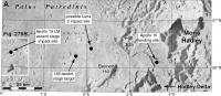
When you consider that LRO is designed primarily to support future manned lunar operations, it's instructive to remember that while most Apollo landing sites had imagery available at between 1 and 3 meter resolution, some of the later sites (particularly Hadley) had much lower-resolution imagery available pre-flight. I believe the best Hadley imagery prior to Apollo 15 was at 22-meter resolution, and was obtained by LO IV. And that photogeologists, straining to bleed data out of imagery that just didn't contain it, were capable of badly mis-identifying small landforms as volcanic when they were primarily impact-related (as with the 3- to 5-meter resolution images used to plan the Apollo 16 landing at Descartes).
All I'm trying to do is make sure we don't forget lessons learned, here, when it comes to lunar geologic investigations. On a world where erosion and landscape modification is now extremely slow, but which has been almost completely gardened, vertically mixed (and somewhat horizontally mixed) right at the surface, you have to carefully select targets which will actually give you greater insights with very-high-resolution imagery. (Remember, Apollo astronauts had a hard time determining rock types, even when they held the rocks in their hands, because they were usually very dust-covered. John Young on Apollo 16 quipped that one rock was so dust-covered that it "defied description." If you can't tell anything about a rock when you hold it in your hand, how much are you going to be able to tell about it at 50-cm resolution?)
And, just to add my voice to the chorus, yes -- Ina is a definite must for detailed imagery. It's one of those places where the very high resolution might provide some real answers...
-the other Doug
Posted by: Phil Stooke Apr 8 2007, 07:30 PM
Early Apollo sites were blanketed by high resolution LO strips, but the Apollo 14 and 15 sites were imaged less intensively - good stereo at medium resolution, but the High Res strips were just samples distributed across the area. At Apollo 14 they landed in one of the high res strips, but at Apollo 15 they landed in an area covered only with the medium resolution stereo - it was LO5, not LO4. The high res strips covered areas initially considered for landing but dropped. By then the Apollo planners were confident that they could land safely without the highest resolution coverage.
Phil
Posted by: Bernard Apr 10 2007, 08:35 AM
I vote for Ina, too.
Posted by: PhilHorzempa Apr 10 2007, 04:58 PM
Another LRO candidate would be the landing sites of Luna 18/Luna 20 and
Luna 23/Luna 24. Each of these Luna craft were sample-return missions.
I put those together as pairs since, according to landing site
coordinates, each lander in that pair is within a few miles of the other. This occurred
because the 1st spacecraft in each pair never launched its Earth-return capsule, for one reason
or another,while the 2nd one did succeed. Apparently, the Soviets just reflew the 2nd one
using the same nav software as for the 1st?
With LRO photos, we will be able to inspect the terrain around each lander, perhaps giving
clues why Luna 18 and 23 did not function correctly. Also, it will be nice to see the specfic
geologic context for each lander, since, as I recall, landing site imagery was not returned
even by the successful "scoopers." (Did some of them land at night?)
One more site of great interest would be the landing site for Luna 15. As far as I can tell,
the Soviets never gave a really clear explanation of what happened to Luna 15. Was it
descending too quickly? Was it damaged while landing? Was it like Surveyor 4 - an abrupt
loss of signal while still several hundred, or several thousand, feet above the surface?
Photos of Luna 15's landing site may tell us a lot.
Another Phil
Posted by: Phil Stooke Apr 10 2007, 06:04 PM
Luna 16 landed at night carrying cameras and artificial lighting. The lights failed. The images were transmitted, showing a landscape weakly lit by earthlight - very poorly exposed. Those images have never been released, but I think modern image processing methods would be able to get useful images from them if the original data tapes could be found in the state archives.
Luna 20 landed in daylight, and its images have been published in part (I think you can find them among these threads).
Then the lander was redesigned and Lunas 23 and 24 did not carry cameras.
Phil
Posted by: GravityWaves Apr 12 2007, 08:24 AM
I would like to see it image the rover tracks - Apollo's lunar rovers, Soviet Lunokhods.
Posted by: J.J. Apr 14 2007, 05:34 AM
I have a soft spot for old Tycho; I'd love to see the kind of rugged landforms in that young crater that have been muted in older regions of the Moon (jagged mountains, hint-hint). 
Posted by: dvandorn Apr 14 2007, 01:31 PM
The problem is, the Moon doesn't really have any jagged peaks. Even around Tycho. Take a look at the pans from Surveyor VII -- even that close to Tycho's rim, the landforms are *still* all softened and rounded-looking.
-the other Doug
Posted by: remcook Apr 14 2007, 08:55 PM
why is that? why is the moon so smooth? there's not much erosion....
Posted by: Phil Stooke Apr 14 2007, 09:34 PM
That's not really true. The surface is constantly subjected to micrometeorite sandblasting and mini-meteorite 'gardening' - processes which don't affect Mars, for instance. Slow, but acting over very long periods.
On top of that, because almost every feature, and every recent feature, is impact-generated, it's covered with or consists largely of unconsolidated rubble. Tycho's central peaks, for instance, though uplifted crust, must be badly shattered and partly covered with fall-back ejecta. The Apennines at Hadley, ditto. So they will tend to assume angle-of-repose type slopes from the start. And to add to the effect, every mid-sized or larger impact creates a seismic event which further subdues all that loose rubble.
Not only that - I would suggest that most steep slopes on Earth are created by erosion. Lack of erosion on other worlds reduces opportunities for steep topography.
Posted by: Phil Stooke Apr 14 2007, 11:03 PM
This shows the area. - duh! - referred to in the Apollo 15 thread. Sorry!
Phil
|
Posted by: monitorlizard Apr 14 2007, 11:05 PM
The ultrastrange swirls of Reiner Gamma get my vote for LRO targeting. I'd like to see all of the LRO instruments used to study this, including the highest resolution images we can get. If it was formed by a comet impact, there may still be volatiles embedded in the lunar soil leaking back into space, so the UV spectrometer might yield the most useful information. Too bad LRO has nothing to study the Reiner Gamma magnetic anomaly with.
Posted by: PhilHorzempa Apr 18 2007, 02:53 PM
I would like to see LRO get high-res images of Copernicus' central peak.
Here is a link to a LPOD discussion of Lunar Orbiter 2's famous photo of
that crater.
This is the LPOD for January 10, 2004 -
http://www.lpod.org/archive/archive/2004/01/LPOD-2004-01-10.htm
If you look closely, then you will see a thin dark line crossing one of
Copernicus' central peaks. This is thought to be a geologic intrusion called
a dike. However, LO2's image is just not sharp enough to be definitive
on that call. LRO could help resolve what type of geologic layering is actually
present in those central peaks.
If you read Chuck Wood's description of that image, then you will notice that he
mentions that the middle peak seems to be split. I think that he is referring to
the one that has the possible dike. However, if it is split, then LRO's high-res
images should reveal a gold mine of info into the history of this area. As any
geologist knows, if you can see layering (as in Victoria Crater on Mars) then you
can read the past in the rocks.
Another Phil
Posted by: Phil Stooke Apr 18 2007, 03:19 PM
Copernicus would be interesting, but Lunar Orbiter 5 also got very good images of the peaks. Check out:
http://astrogeology.usgs.gov/lo-cgi-bin//vhFrameListPage.pl?mission=5&frame=151&site=37&siteName=Copernicus
and other frames from:
http://astrogeology.usgs.gov/Projects/LunarOrbiterDigitization/statusmaps_veryhigh.html
Not to say more would not be nice, especially for areas lost in shadow in LO5 images.
Phil
Posted by: charborob Jun 17 2009, 07:59 PM
Resurrecting an old thread here.
You can view LRO's LROC targets on the following page:
http://target.lroc.asu.edu/output/lroc/lroc_page.html
You can even propose your own favorite target.
(I seem to remember someone posting a map of LROC targets somewhere, but I can't find it anymore. Unless I saw that on another website. Sorry if I am duplicating a previous post.)
Posted by: Phil Stooke Jun 18 2009, 11:00 AM
The maps are here, half way down the page. And they were an LPOD. Also check out the Constellation targets (just above the maps, two PDFs)
Phil
http://ser.sese.asu.edu/LSM/targeting.php
Posted by: SpaceListener Jun 18 2009, 02:03 PM
Thanks Phil for the fantastic link.
Posted by: stevesliva Jun 18 2009, 03:47 PM
Holy schmoly. That really drives home the amount of labor-intensive planning these orbiters do ahead of time. We want to take photos of these 6,494 places. Sheesh. Sometimes 5000 just won't do. Sorting the spreadsheet by column E 'human artifacts' is fun. Looks like they're depending on some Stooke fellow for the Luna and Lunokhod locations.
Posted by: Phil Stooke Jun 18 2009, 04:18 PM
We're all doomed!
Phil
Posted by: PhilCo126 Jun 19 2009, 11:37 AM
on the contrary, looking forward to the extreme closeup images of the lunar surface with a spatial resolution of 0.5 meters per pixel over 5 kilometers wide swathes. Wishing You had these available for the International Atlas of Lunar Exploration to show the Ranger impact sites and Surveyor, Luna,... hardware left there in the 1960s and 1970s.
And the black monolith in the Moon crater Clavius
Posted by: ugordan Jun 19 2009, 11:47 AM
Nonsense.
Everybody knows the monolith is in fact located near Tycho.
Posted by: Zvezdichko Jun 19 2009, 11:49 AM
There is a moon crater Clavius, plus a fictional base named Clavius.
Now, seriously, I really like LRO to find out the location of the old Soviet probes - Luna 9, for example..
Posted by: Phil Stooke Jun 19 2009, 12:55 PM
Me too, but that and Luna 13 will be extremely difficult.
Phil
Posted by: Tom Tamlyn Jun 19 2009, 03:43 PM
I've read that it will take a couple of months to fine tune the orbit.
How soon after that can we expect some high resolution pictures of an Apollo landing site?
(I realize that the scientific value isn't so high; I'm just eager to see them.)
TTT
Posted by: ugordan Jun 19 2009, 04:02 PM
I read somewhere they will be trying to capture an image of the Apollo 11 landing site in time for the 40th anniversary.
Posted by: jmknapp Jul 8 2009, 10:27 AM
According to http://lroc.sese.asu.edu/whereislro/ LRO is currently traversing longitude 71E and 109W in its orbit. Since its longitude moves westward about one degree every two-hour orbit, it should fly pretty close to the Apollo 11 landing site (at 23E) in about 71 - 23 = 48 orbits or about 4 days. Could it happen?
Joe
Posted by: Stu Jul 8 2009, 10:36 AM
Hmmm... let me think... 40th anniversary coming up... Constellation floundering... public support for a "Return To The Moon" sorely lacking... conspiracy theorists insisting we never went to the Moon in the first place... a science-friendly but budget-reviewing new President to impress....
I'm guessing "yes".

Posted by: ugordan Jul 8 2009, 11:12 AM
I'm guessing that even if it's taken, it won't be released until the actual anniversary date, probably on the day of the landing. Maximum PR impact etc.
Posted by: jmknapp Jul 8 2009, 12:16 PM
I wonder what the PR impact of such an image would be though, outside the enthusiast ranks. What would it show? At 50cm/pixel at best (and probably more like 1m/pixel) it's not like much detail on the LEM platform (diameter 5m) or whatever would be resolved, right? People might say, "where are the footprints?"
Maybe Apollo 17 would be of more photographic interest? Since the rover traveled around quite a bit (35km total traverse), is it possible that its tracks would show up on the photo as discernible lines? It's at longitude 31E which should come up a bit quicker, this Saturday.
Posted by: ugordan Jul 8 2009, 01:49 PM
MRO didn't show much detail on the rovers and Phoenix either, but it was a large PR impact for those of us who did care. The rest of the folks couldn't care less anyway. I expect the same with LRO images. What will be visible depends on solar elevation, lower elevation would benefit contrast between hardware and surface and give longer shadows, but mostly albedo markings like footprints would benefit from a lower phase angle. Yes, the Apollo 11 site isn't the best candidate, but given the approaching anniversary it would be a fitting way to mark the event by imaging it first. The rest of the sites can wait for their anniversaries
Posted by: Stu Jul 8 2009, 02:24 PM
I don't care how vague or fuzzy or blurry the images are when they appear, they'll still be very moving, I'm sure. I remember how I felt when I saw that first MRO shot of Oppy on the edge of Victoria Crater, I actually didn't say a word for about five minutes, I just sat there thinking "Wow... we built that and sent it to Mars, where it was photographed by something else we built and sent to Mars..."
(BTW, I'm mega-chuffed that Phil Plait has just plugged my 'LRO vs Apollo Hoaxers' blog post on his "Bad Astronomy" blog. )
Posted by: FordPrefect Jul 8 2009, 04:15 PM
Oh boy, this mission is so exciting. Can't wait for those images of Apollo hardware and other stuff on the surface. Hopefully they'll take some snaps of the Apollo 17 ascent stage impact site on the South Massif too.
Posted by: ilbasso Jul 8 2009, 06:18 PM
It will be interesting to see those sites in the light of the setting sun - shadows will be going in the opposite direction from when we last saw those sites. Given the very low sun angles in the current LROC photos, I'm sure that the topography and any visible artifacts will be very dramatically lit.
Posted by: charborob Jul 8 2009, 08:46 PM
If I am not mistaken, the NAC on LRO takes images in very narrow stripes (3 km? wide). I guess it could easily miss the Apollo 11 site. I mean, it could image an area just to the East of the landing site on one orbit, and the area just to the West on the following orbit, unless the swaths overlap, of which I am not certain at near-equatorial latitudes. Can LROC be pointed a bit sideways, or is it allways pointing directly down?
Posted by: djellison Jul 8 2009, 10:45 PM
LROC is bolted to LRO, so, like MRO with HiRISE, to image off-nadir you have to command the spacecraft to cant over one direction or the other. I would fully expect them to be able to not only successfully target any known landing site, but to nail it pretty much dead centre.
Posted by: mcaplinger Jul 8 2009, 11:02 PM
There are always map uncertainties, but in the case of the Apollo landing sites the ALSEP laser retroreflectors allow very accurate knowledge of the site position in the Earth reference frame.
But I believe the spacing at the equator orbit to orbit is about 30 km, so slewing off-nadir would be required for arbitrary targets.
Posted by: brellis Jul 9 2009, 10:03 PM
Did LRO detect the "reddish hue" on the lunar surface during the penumbral eclipse on July 7th? http://planetary.org/blog/
Posted by: floron Jul 10 2009, 12:09 AM
From the LRO blog: "Saturday NAC imaging is again planned with our first off-nadir slews to perform the requested targeting. " hmm. i wonder what target was being requested...?
http://lroupdate.blogspot.com/
Posted by: Ian R Jul 10 2009, 12:42 AM
Just in case an attempt at imaging the the Apollo 17 landing site really is imminent, I thought I would post this mosaic I made a while ago from frames taken from the 16-mm ascent film shot just after pitch-over. As far as I'm aware, this is currently the best overhead view of the region where Challenger landed, and it would be interesting to compare this to the putative LRO view of the same area:
|
Posted by: jmknapp Jul 10 2009, 01:42 AM
http://lroupdate.blogspot.com/
Maybe so! Off-nadir might make for an more artsy angle, plus it's a pretty hilly area compared to the A11 site. I was just looking on line for a broader view of the "Taurus Littrow" area & couldn't really find one, but here's a snapshot of an image from a book:
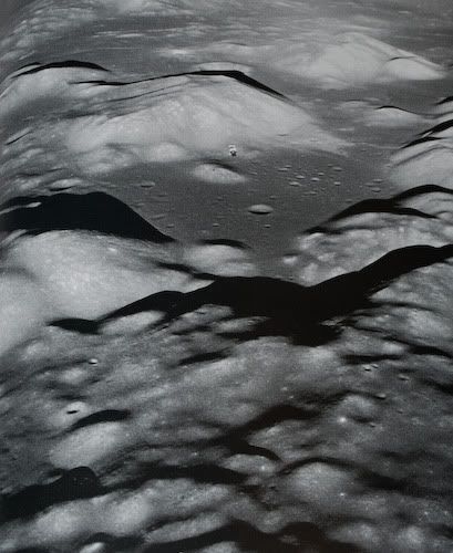
Apollo 17 "Challenger" landed in the flatter region among the smallish craters to the right. The command module "America" is in this photo, silhouetted against the base of the South Massif.
Posted by: floron Jul 10 2009, 04:00 AM
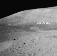
perhaps they'll get some nice pics of the HOLLYWOOD signs...
(http://www.unmannedspaceflight.com/index.php?showtopic=5160&st=45)
|
Posted by: charborob Jul 10 2009, 04:50 PM
Roughly guessing based on the http://lroc.sese.asu.edu/whereislro/ page, I'd say that LRO will be passing above the Apollo 11 site on Saturday. Since LRO is in a 30x199 km orbit, it's altitude above Tranquillity base will be around 100 km. So we may expect something like 1m resolution?
Posted by: Zvezdichko Jul 10 2009, 06:39 PM
I also think that an attempt is possible to be made if not tomorrow, in the next few days. Next week NASA is celebrating the anniversary. It'll be a huge PR for the agency.
Posted by: charborob Jul 10 2009, 06:51 PM
Except that if they don't succeed in imaging the Apollo 11 site on Saturday, the next opportunity will be in about 4 weeks, when the ground track crosses the area again.
Posted by: Zvezdichko Jul 10 2009, 06:54 PM
Yes, but we had six Apollo landings, we still have opportunities.
Posted by: jmknapp Jul 10 2009, 06:54 PM
Wouldn't it be two weeks, when the other side of the orbit (ascending side?) swings around?
Posted by: Zvezdichko Jul 10 2009, 07:05 PM
And when the place will be in total darkness.
Posted by: climber Jul 10 2009, 07:55 PM
Except we are 10 days away from july 20th
Posted by: jmknapp Jul 10 2009, 08:26 PM
Ah--of course.

I made an animation of the LRO passes over the Apollo 11 site, using the "mission baseline v8" data given at http://lroc.sese.asu.edu/downloads.html. That baseline was for the original launch date of July 17, & so is about 1 day ahead of schedule. I just figured out how to add fixed points like the Apollo sites to the map projection & this is a first cut:
http://cboh.org/~jmk/lro_apollo11.mpg (54MB mpg file).
I put in all 50 primary LRO targets into the model, but only the handful visible on these ~2 orbits come up.
Joe
Posted by: Paul Fjeld Jul 11 2009, 02:59 AM
VERY cool, Joe!
So (just thinking out loud while I run around my cylinder, punching the air :-) the day late means that LRO will be roughly 13 degrees east of the target compared to your LRO_Cockpit view? Looking at the V8 data, the LRO orbit traverses ~12 degrees of Longitude per day? So tomorrow, the cameras should be passing over the Apollo 11 site with a nice 40 degree western sun (or so) and be baked out and focussed. Maybe a shot from 120km will reveal something neat that can be released with appropriate hoopla in the next week or so?
EDIT: I see now that LRO is about to pass over the Apollo 17 site with an even more dramatic sun angle. From 120 km high, the Descent Stage structure (not including the gear) will be nearly 4 pixels wide; the low sun shadow should be considerably more than that. Hope those cameras are baked out and ready!
2nd EDIT: I just read the previous couple of pages and see y'all had figured this out already. Feel a little silly...
Posted by: jmknapp Jul 11 2009, 04:22 PM
Glad you got the musical reference! Going by the v8 data, I get 12.94 degrees/day in the commissioning orbit (and 13.13 degrees/day in the mapping orbit). So that amounts to 360 degrees in about 27.4 days. I suppose that makes it sun-synchronous? BTW, assuming that LRO passes over the Apollo 11 site around 4am tomorrow UT (by my calc) the sun will be at around 10 degrees elevation.
Posted by: Zvezdichko Jul 11 2009, 04:31 PM
Can't wait to see the new photos!
Posted by: Paul Fjeld Jul 11 2009, 05:32 PM
I don't think so. The beta angle is supposed to shift so that by the time LRO is going over the (South?) pole at the time of maximal lighting (summer solstice), it is as near to zero as possible (within some 10 degrees or so) - which was the driver for the launch window. The idea being that they needed passes over the permanently shadowed areas of a pole when those shadows were minimal(?). I am certain the beta angle changes completely through the whole mission or they wouldn't need to do a 180 yaw at the midway point to get the solar arrays shifted to the other side. Plus you wouldn't need that beta gimbal joint on the arrays.
That will make for some really great images! Much better than 40. The LM shadow will be >so< obvious - I'm sure we'll see the Reflector and Seismometer - maybe even the flag will be a pixel if it did in fact fall over... whet our appetites for the low orbit passes!
Posted by: Zvezdichko Jul 11 2009, 05:43 PM
You forget something. The flag was made of nylon. I'm sure there's only the pole left. The rest is ashes.
Plus, the resolution won't be that good.
Posted by: Paul Fjeld Jul 11 2009, 06:53 PM
You could be right about the flag - I still harbor a hope that the nylon will not have disintegrated. But the resolution from that altitude is about 1.2 meters per pixel, so if there is a bleached flag flat on the surface, we should see it.
I just googled the specs on Nylon, for what it's worth, and one site (Beaver Manufacturing Co.!) says it is resistant to dry heat but degrades at prolonged exposure of 180 degrees C. The max temperature on the lunar surface is less than 150 degrees C, no?
But I have no idea if it is that simple a calc for the Nylon on the moon over 40 years of solar cycles...
Posted by: John Moore Jul 11 2009, 08:09 PM
ASU is always a wonderful resource for such images -- the zoom feature, literaly, puts you on the surface
Checked out Littrow region -- see http://wms.lroc.asu.edu/apollo/view?image_id=AS17-M-0597
John
http://www.moonposter.ie/
Posted by: Sunspot Jul 12 2009, 12:01 PM
The LRO website seems to be really temperamental....
Posted by: Zvezdichko Jul 12 2009, 12:07 PM
Yes, really... goes down regularly.
Posted by: jmknapp Jul 12 2009, 01:57 PM
My s.o. took a picture of the moon this morning with her camera: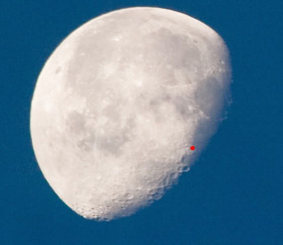
I put a red dot at the Apollo 11 landing site--looks like a nice low sun angle if they took the shot.
Posted by: ilbasso Jul 13 2009, 12:12 AM
I think I could have seen the flag if it wasn't for that pesky red dot!
Also, remember that Buzz Aldrin says that the last thing he saw of the landing site during ascent was the flag blowing over in the ascent engine's exhaust plume.
Posted by: Zvezdichko Jul 13 2009, 12:26 AM
OK, several amateur pics from me, too:
http://www.space-bg.org/snimki/luna/moon1.JPG
http://www.space-bg.org/snimki/luna/moon2.JPG
http://www.space-bg.org/snimki/luna/moon3.JPG
12-jul-09/10:50 AM GMT...
Call me ignorant, but I really can't identify the landing site of Apollo 11. Not that it's the best quality.
Posted by: SpaceListener Jul 13 2009, 01:55 PM
Good! You answered me what I was searching about the Moon phase when Apollo 11 landed on Moon.
I knew that the Moon was either as waxing crescent or waning crescent. Now I see it.
That time is very nice for visual effects with contrasts of light.
A little question of OT, What about was the temperature on the Moon surface during the astronauts external
walk activities?
Posted by: jmknapp Jul 13 2009, 02:00 PM
Just verified that per the "mission baseline" SPICE data. The beta angle on the descending node (currently very low) increases to ~90 degrees in about 3 months, goes back to zero at 6 months, then the ascending node will be in sunlight, increasing to ~90 degrees at 9 months & back to zero at the end of one year. So I guess that means that LRO completes a sweep around the moon in one sidereal period (27.3 days) rather than the full moon to full moon period of 29.5 days.
Posted by: Phil Stooke Jul 13 2009, 02:16 PM
"Good! You answered me what I was searching about the Moon phase when Apollo 11 landed on Moon.
I knew that the Moon was either as waxing crescent or waning crescent. Now I see it. "
Spacelistener - that image does not show the phase at the time of the Apollo 11 landing - in fact it was almost the opposite, a waxing crescent. In other words, very early morning at the landing site.
Phil Stooke
Posted by: SpaceListener Jul 13 2009, 02:31 PM
Thanks Phil,
Why did NASA select that the landing Apollo 11 time was in early morning? Due to temperature reasons? I don't see difference temperature between early, noon and late day of Moon since it has no atmosphere but I am still figuring it out.
Posted by: djellison Jul 13 2009, 02:34 PM
You want to have the sun fairly low, so that when landing, the craters and boulders stand out well.
I would suspect that you target for the beginning of the lunar day, giving you a few days until the sun gets too high.
Posted by: SpaceListener Jul 13 2009, 02:59 PM
Full inline quote removed - ADMIN
Your post sounds very reasonably.
That is for a better visibility during the landing and EWA which is very important for security reasons since the Moon light is so intense, that, I imagine, a person would have lots difficulties to discern the surface line.
Posted by: Phil Stooke Jul 13 2009, 03:29 PM
You need the low sun to discern surface features, as Doug said. The most important reason for targeting early morning rather than late evening was to allow the approach to the site to occur over the illuminated region for navigation updates - they tracked landmarks to update their position. Also this will allow for landing delays. If you have some little problem that prevents landing on one orbit you can go for the next, or the next again. In the evening, miss an orbit or two and you will be on the surface during the night. That would be even more important for the longer missions.
Lighting is much more important here than temperature.
Phil
Posted by: djellison Jul 13 2009, 03:37 PM
I'm sure I've read one astronaut, probably from a J class mission, comment that just from one EVA to the next, the lighting change was so significant that the place looked very very different on the ground.
Posted by: Phil Stooke Jul 13 2009, 04:03 PM
Right, it's very apparent in the surface photos. So it makes perfect sense to land with the lowest sun angles and see all the hazards (except for the blowing dust... but that's a different issue), and allow the sun to get higher during the EVAs. It makes no sense to land with washed-out topography and run the risk that a landing delay would mean the last EVA would have to be cancelled due to approaching night.
Phil
Posted by: SpaceListener Jul 13 2009, 04:04 PM
Fantastic, Doug and Phil statements have closed very well about all reasons for early morning landing on Moon.
However, for just confirmation of my hipothesis is that the Moon surface temperature on that time on Sun side is so hot as over than 100 centigrades Celius, isn't it?
Posted by: djellison Jul 13 2009, 04:48 PM
http://www.solarviews.com/eng/moon.htm
Mean surface temperature (day) 107°C
Mean surface temperature (night) -153°C
Maximum surface temperature 123°C
Minimum surface temperature -233°C
Posted by: SpaceListener Jul 13 2009, 05:57 PM
Thanks Dougs for the links. I knew about these temperatures and I am sorry that I didn't explain thoroughly about the hypothesis. As the Apollo 11 landing time was on early morning, close to the Lunar Terminator, and am suppossing that the real temperature must be lower than the maximum.
By the way, I have seen a picture taken by the LCROSS, from infrared camera during its approach to the Moon. It showed that the temperature starts to lower at the Terminator. See the next link: http://www.nasa.gov/images/content/362267main_ACD09-0117-002_full.jpg.
Well, I hope that one of the LRO instruments, DIVINER would be able to map the Moon surface temperatures. Patience!
Posted by: Phil Stooke Jul 15 2009, 06:36 PM
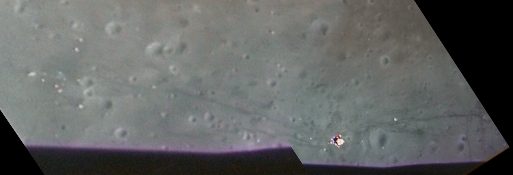
The first radar image from LRO has been released:
http://www.nasa.gov/mission_pages/Mini-RF/multimedia/LRO_Mini-RF_turned_on.html
Phil
Posted by: Sunspot Jul 15 2009, 06:58 PM
And an interesting article from space.com
http://www.space.com/missionlaunches/090715-apollo-landing-site.html
Posted by: glennwsmith Jul 16 2009, 04:12 AM
Speaking of radar, and in anticipation of the LCROSS impact, can someone briefly explain (or point me to an explanation of) how the Arecibo observatory has been able to map the poles of both the Moon and Mercury, finding water at the latter but not the former? Seems like it would have the same (impossible) tangential view that we do from earth. Or is its radar sufficiently robust to be able to penetrate the poles "from the sides" and obtain useful reflections that are processed tomographically?
Posted by: nprev Jul 16 2009, 04:31 AM
In the case of Mercury I'd guess that Arecibo's acuity there is at least partially a function of the planet's orbital inclination with respect to the ecliptic (7 deg.), which allows a slightly better look angle at the poles at certain times.
Arecibo's radar isn't nearly powerful enough to do a CAT-scan of the lunar poles, though. (I don't think that any ground-based radar yet built could do that.)
Posted by: dvandorn Jul 16 2009, 04:48 AM
Also, isn't it true that there is still a fair degree of controversy over the "discovery" of water ice at the Mercurian poles by Arecibo radar mapping?
I'm tempted to say that all we *really* know is that Mercury's poles show something different than the Moon's poles to Arecibo's radar mapping program. I don't think we can say with any degree of certainty what compositional and environmental differences are causing it.
-the other Doug
Posted by: jmknapp Jul 16 2009, 12:04 PM
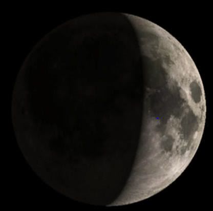
I knew that the Moon was either as waxing crescent or waning crescent.
Here's about what it looked like at the moment of landing, 20JUL1969 20:17:40 UT (blue dot at the A11 landing site):
Posted by: Zvezdichko Jul 16 2009, 06:35 PM
Btw happy anniversary, today restored video footage from Apollo 11 was released. I do wonder if we will see any LRO pictures of the landing sites in the near hours/days.
Posted by: ugordan Jul 16 2009, 06:43 PM
Via NSF.com:
MEDIA ADVISORY: M09-133
NASA BRIEFS MEDIA ON NEW IMAGES OF APOLLO LUNAR LANDING SITES
GREENBELT, Md. -- NASA's Lunar Reconnaissance Orbiter, or LRO, has
sent back its first images of Apollo lunar landing sites. The agency
will release the images Friday, July 17, at noon and hold a
teleconference at 2 p.m. EDT to discuss the photos and future plans
for the LRO mission.
Participating in the teleconference are:
Michael Wargo, chief lunar scientist, NASA Headquarters, Washington
Richard Vondrak, project scientist, Lunar Reconnaissance Orbiter,
NASA's Goddard Space Flight Center, Greenbelt, Md.
Mark Robinson, principal investigator, Lunar Reconnaissance Orbiter
Camera, Arizona State University
To participate in the teleconference, reporters should contact Grey
Hautaluoma at 202-358-0668 or Andy Freeberg at 301-286-0746, by noon
Friday.
To listen to the event online, visit:
http://www.nasa.gov/newsaudio
For more information about LRO, visit:
http://www.nasa.gov/lro
Posted by: Phil Stooke Jul 16 2009, 07:06 PM
Yummy!
Phil
Posted by: Paul Fjeld Jul 16 2009, 08:06 PM
I think they could have bagged every single landing site with that great low, western sun angle this past week. Plus who knows what else (LM, SIVB craters).
Posted by: jmknapp Jul 16 2009, 08:21 PM
In the July 15th space.com article referenced upthread, I guess they were sandbagging a little as the photos must already have been taken several days before. Anyway, that article says:
The descent stages of other Apollo missions should be visible, too. And the orbiter will look for Apollo Lunar Surface Experiment Packages (ALSEP) an array of scientific devices deployed on the lunar surface by Apollo moonwalkers.
"I know we'll see the descent stages...and I know we'll be able to find the ALSEPs," Robinson told SPACE.com. "You'll see things sitting on surface." Churned-up lunar regolith, the tracks of the three lunar rovers used during the Apollo program, should also be visible.
http://www.space.com/missionlaunches/090715-apollo-landing-site.html
Posted by: John Moore Jul 16 2009, 08:53 PM
Good description http://www.nasm.si.edu/research/ceps/research/moon/radar_poles_detail.cfm by Campbell who was involved with those radar moon images.
John
http:///
Posted by: Stu Jul 16 2009, 09:23 PM
This map might be helpful tomorrow, after the landing site images are released and we're all trying to identify features / tracks at Tranquility Base :-)
http://history.nasa.gov/alsj/a11/a11traverse.gif
Posted by: Phil Stooke Jul 16 2009, 09:46 PM
This one might be useful too...
http://www.lpi.usra.edu/resources/mapcatalog/LPST/ap_11_12_14/
Phil
Posted by: ilbasso Jul 16 2009, 10:29 PM
MEDIA ADVISORY: M09-133
NASA BRIEFS MEDIA ON NEW IMAGES OF APOLLO LUNAR LANDING SITES
...
First of all, maybe this was supposed to be nsf.gov, not .com.
There's nothing on that website or the LROC website about this that I could find. Maybe it was pulled?
Posted by: Phil Stooke Jul 16 2009, 10:44 PM
Presumably NASA Space Flight, not National Science Foundation!- though I don't see the announcement on that site.
But see it here:
http://www.nasa.gov/news/media/newsaudio/index.html
Phil
Posted by: mcaplinger Jul 17 2009, 02:05 AM
Though the article doesn't say, I'm fairly sure that interview occurred before the images were taken, if not before the launch of LRO, and probably refers to expected image quality from 50 km. From a higher altitude the resolution will obviously suffer.
Posted by: Paul Fjeld Jul 17 2009, 02:25 AM
I agree. Robinson was talking before they got anything - no sandbagging. But assuming 1.2 meter/pixel at the 120km altitude, the LM Descent Stage and its shadow should be defined by no less than 70 pixels. It should be REALLY obvious and I bet you'll make out the other little bits. I'm hoping they'll say "here is the '11 site... oh yah, and here are the rest!"
Posted by: jmknapp Jul 17 2009, 09:43 AM
Ah, that makes sense as the current altitude crossing the equator (per Paul F.) is about 120 km.
Posted by: Zvezdichko Jul 17 2009, 09:45 AM
Well, this will still allow us to see something
Posted by: djellison Jul 17 2009, 12:48 PM
The LEM is approx 4.5 metres across. At 1.2m/pixel - that's 3-4 pixels across, a total of perhaps 16 pixels of LEM.
Assuming a height of 4 meters ( which is generous) - and illumination at 10 degrees - the shadow will be another 17 or so pixels long.
Doug
Posted by: Paul Fjeld Jul 17 2009, 02:30 PM
Your calculations are close. The LM structure is 4.22 m across, but footpad edge to footpad edge (still bright Kapton?) is 9.45 m. I would add the gear to show up as another pixel at least making the LM 25 pixels (5 ^2). The top of the LM Descent Stage structure is 3.18 m but the tops of the plume deflectors are at 4.23 m. So the shadow trig has it from 18 to 20 meters long. So 17 or slightly fewer pixels not squared but maybe a third of that is at least 75 pixels. So I revise my estimate upwards: the LM will be defined by at least 100 pixels.
Then there will be extra flotsam like the brightly lit backpacks and other things. We'll know soon!
EDIT: of course I'm neglecting slant range: this all assumes LRO was nearly right above the site when the pic was taken.
Posted by: djellison Jul 17 2009, 02:53 PM
Oh - ok - you were counting ALL the pixels. Anyway - I started a new LRO thread for Apollo sites - we'll need it in about an hour or two hopefully
Posted by: jmknapp Jul 17 2009, 03:01 PM
Since the ground tracks on successive passes are about 30 km apart, and the vantage point is 120 km high, I suppose there needn't be much slant (15/120 = 7 degrees).
Posted by: glennwsmith Jul 18 2009, 08:31 AM
John Moore, thanks for link to details on Arecibo radar mapping of the Moon's poles. So, there was no magic involved -- Arecibo had the same oblique view that we do, and as a result was only able to examine 25% of the craters' permanently shadowed areas -- and obviously not the deepest areas. Thus, as someone else mentioned, there is still hope that real "hit it wth a pickaxe" ice can be found on the moon -- lunar gold!
Posted by: John Moore Jul 18 2009, 10:45 AM
Re: Arecibo + radar.
Glenn, you're welcome...had been reading up on it just a week earlier, so it was close to hand
John
Posted by: Zvezdichko Jul 19 2009, 02:57 PM
Uh... what happened to the other thread?
Posted by: Phil Stooke Jul 19 2009, 03:26 PM
Yes, I was wondering that... but it's back now...
Phil
Posted by: glennwsmith Jul 21 2009, 01:30 AM
Given that the main goal of LCROSS is to search for water ice at the moon's south pole, I suppose this is an appropriate place for the following comment, namely, that the success of said search -- and I am not predicting here that it will be successful -- will pretty much end the Mars vs. Moon debate in respect to which of the two receives our next big push. But that becomes another topic for another time and place . . .
Posted by: Paul Fjeld Aug 5 2009, 11:55 AM
They updated the file to v10. It looks like it tracks pretty closely with the imaging data now.
Posted by: jmknapp Aug 5 2009, 12:13 PM
I downloaded the v10 files and indeed it tracked well, differing from the position given by http://lroc.sese.asu.edu/whereislro/ by only a few minutes. BTW, the "Where is LRO" site now seems to be gone (check link). So the question becomes "Where is Where is LRO?"
I hear that up-to-date SPICE kernels are provided to the various centers on a daily basis but those aren't available to the public. That contrasts to, say, MRO, where updated files are continually posted to the NAIF public website, including both planned and as-flown instrument pointing files (so-called CK kernels). Cassini also does this. My understanding is that the older programs (particularly Cassini, being an old-school big budget project) were more committed to this. In Cassini's case, they even provide "science plan" kernels containing text information about the type and purpose of observations, correlated with instrument command sequences.
Eventually the pointing and trajectory files will be posted to the PDS, but only after 8 months or something like that. So near real time for LRO looks to be a no go, as far as the public is concerned.
Posted by: Paul Fjeld Aug 5 2009, 03:19 PM
I have no idea how much effort it takes to keep going something like "Where is LRO." I would think it would be trivial: just point some telemetry or tracking data at an automatic web thingy and off you go.
I wish NASA would, as a matter of course, maintain an up to date data stream of a mission's state vector and attitude. They could have a standard web protocol and each mission's data folks would plug those 9 numbers in with a time stamp (every minute or second) and we could all do with it what we wanted. We would know where pics were taken from instantly and, where there are interesting mission events, simulate them if we have the skill or interest. Planetariums could fly along with some missions - landers would be especially fun to follow in "real" time.
Powered by Invision Power Board (http://www.invisionboard.com)
© Invision Power Services (http://www.invisionpower.com)