Printable Version of Topic
Click here to view this topic in its original format
Unmanned Spaceflight.com _ MSL _ Atop/Around the Greenheugh Pediment
Posted by: PaulH51 Mar 6 2020, 04:33 PM
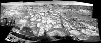
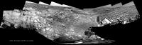
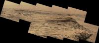
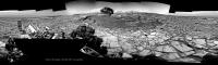
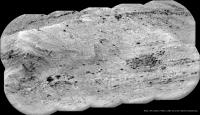
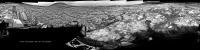
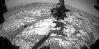
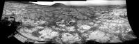
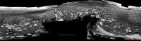
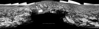
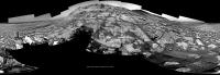
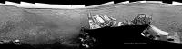
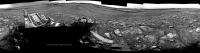
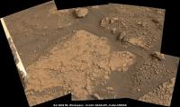
Sol 2695: Just a short drive / climb, but a very welcome one to get all 6 wheels off the slope and onto the top of the pediment 
Roughly stitched L-NavCam partial pan using MS-ICE with the available images. I'm sure the full 360 will be memorable...
BTW: maybe a good time for a new thread? (Traversing the Greenheugh Pediment?)
|
Posted by: Sean Mar 7 2020, 03:32 AM
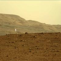
Some context shots with a roughly scaled Curiosity perched on the edge of Greenheugh...
https://flic.kr/p/2iBxvek
https://flic.kr/p/2iByTQw
...grabbed from my 1.8 billion pixel http://www.gigapan.com/gigapans/196659 map.
Posted by: nprev Mar 7 2020, 05:53 AM
Stunning, Sean. 
Re new thread: Yeah, possibly. That's Emily's call, though; she's been most carefully curating the journey of MSL here.
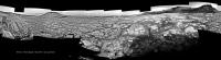
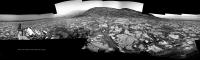
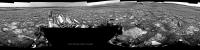
Posted by: jvandriel Mar 7 2020, 10:01 AM
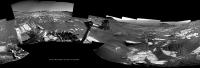
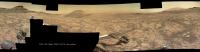
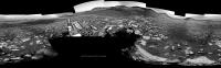
The Navcam L view on Sol 2695.
Jan van Driel

|
Posted by: HSchirmer Mar 7 2020, 06:07 PM

https://flic.kr/p/2iBxvek
I feel like Lawrence of Arabia fumbling for his binoculars after his guide Tafas shouts "Bedu" - WHERE?
|
Posted by: Julius Mar 7 2020, 06:46 PM
Greenheugh pediment looks like its going to be a rough traverse for the rover. What does the pediment represent?
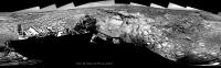
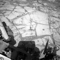
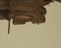
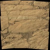
Posted by: PaulH51 Mar 7 2020, 10:21 PM
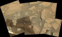
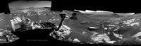
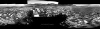
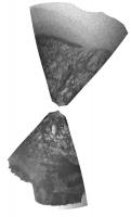
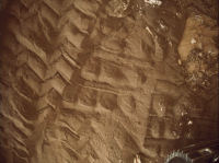
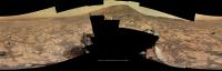
2695 Arm workspace L-MastCam (raw MS-ICE)
|
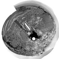
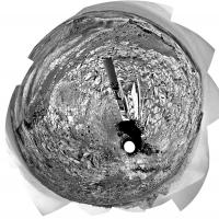
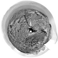
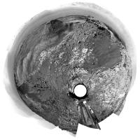
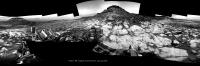
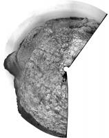
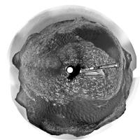
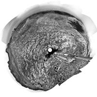
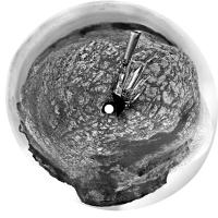
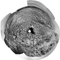
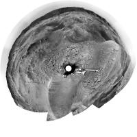
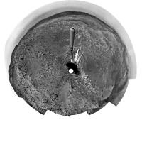
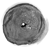
Posted by: Phil Stooke Mar 8 2020, 12:52 AM
Jan's sol 2695 panorama in circular form.
Phil
|
Posted by: Phil Stooke Mar 8 2020, 01:11 AM
Julius: "Greenheugh pediment looks like its going to be a rough traverse for the rover. What does the pediment represent?"
Not sure, but you might find this LPSC abstract interesting:
https://www.hou.usra.edu/meetings/lpsc2020/pdf/2337.pdf
Originally the pediment was interpreted as an alluvial fan, sediment swept down Gediz Vallis by flowing water, but that's not the prevailing view at the moment.
Phil
Posted by: pbanholzer Mar 8 2020, 05:26 AM
Here's an abstract from 2019 showing in Fig. 4 a projection from the Greenheugh to the Stimson.
https://www.hou.usra.edu/meetings/ninthmars2019/pdf/6296.pdf
Posted by: Julius Mar 8 2020, 06:17 AM
Thanks Phil, pbanholzer.appreciated.
Posted by: charborob Mar 8 2020, 01:27 PM
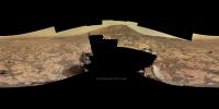
Sol 2695 Lmastcam:

|
Posted by: charborob Mar 8 2020, 01:32 PM
How do you pronounce "Greenheugh"? (Not evident for a French speaker.)
Posted by: centsworth_II Mar 8 2020, 05:28 PM
Not evident for an English speaker either!
Posted by: djellison Mar 8 2020, 05:54 PM
Everyone Ive heard say it says Green Hue.
Posted by: PaulH51 Mar 9 2020, 09:24 AM
Concur - Ashwin also uses Green Hue in this recent video https://youtu.be/o12KsNmoMhQ?t=87
Posted by: Sean Mar 9 2020, 01:35 PM
Better angle on Greenheugh...
https://flic.kr/p/2iChW6D
...Curi at sol 2695 position.
Posted by: neo56 Mar 9 2020, 02:15 PM
Panorama taken with MC Right on sol 2696 merged with two MC Left pictures:
https://flic.kr/p/2iCqTT3
Posted by: jvandriel Mar 9 2020, 03:33 PM
The Navcam L view on Sol 2698.
The rest of the images will be added later.
Jan van Driel
|
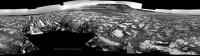
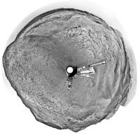
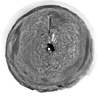
Posted by: jvandriel Mar 10 2020, 12:45 AM
and the Complete Sol 2698 Navcam L view.
Jan van Driel
|
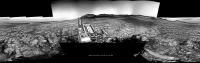
Posted by: Ant103 Mar 10 2020, 10:53 AM
Sol 2596 Mastcam100 panoramic.
http://www.db-prods.net/marsroversimages/curiosity-2020.php#3
Posted by: PaulH51 Mar 10 2020, 10:45 PM
Really enjoying the expertly de-bayered panoramas posted here. Many thanks...
Here's the raw L-MastCam 2698 arm workspace assembled in MS-ICE
|
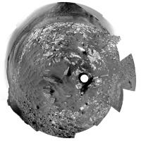
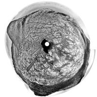
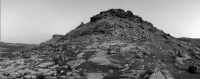
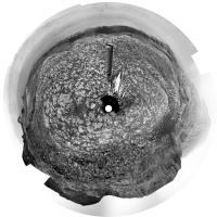
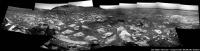
Posted by: Phil Stooke Mar 10 2020, 11:42 PM
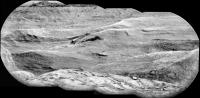
Here is Jan's sol 2698 panorama in circular form. It shows the rugged landscape quite well. This looks like wheel-busting terrain to me.
Phil
|
Posted by: elakdawalla Mar 11 2020, 04:42 PM
Hi folks, new rocks, new thread! http://www.unmannedspaceflight.com/index.php?showtopic=7442&view=findpost&p=246873 where Phil et al. documented this moment.
Posted by: PaulH51 Mar 11 2020, 10:32 PM
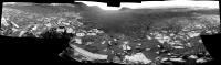
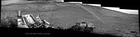
Partial end-of-drive R-Navcam pan from sol 2700 (Site/drive 79-588) hopefully to assist in pinpointing the location while we wait for the remaining frames.
The plan stated they were driving west looking for a drill site... This location appears to tick some of the drill site boxes
|
Posted by: tanjent Mar 12 2020, 12:03 AM
http://www.db-prods.net/marsroversimages/curiosity-2020.php#3
Ant, are those images available for download? Am having some trouble figuring out how. Sorry.
Posted by: Ant103 Mar 12 2020, 09:04 AM
@tanjent : which images ? The panoramic ? If that's the case, just follow the link by clicking the picture, you would find a gallery with the image, and links bellow.
Edit : Sol 2700 Navcam panoramic.
http://www.db-prods.net/marsroversimages/Curiosity/2020/Sol2700_pano.jpg
Posted by: PaulH51 Mar 12 2020, 07:49 PM
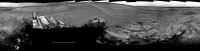
Sol 2699 R-MastCam partial pan of just 30 frames, assembled in MS-ICE, reduced to 5000px wide, debayered, but without further processing
|
Posted by: Phil Stooke Mar 12 2020, 08:37 PM
This is Damia's panorama in circular form - giving a good location for a map update. Thanks, Damia!
Phil
|
Posted by: monty python Mar 13 2020, 05:51 AM
This is caprock so it might be hard to drill. I hope we get one!
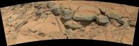
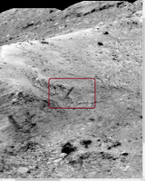
Posted by: PaulH51 Mar 13 2020, 06:47 AM
It would be nice to see them drill / sample one of those darker (capping) rocks, but because of the Feed Extended Drilling) they would need to find a really stable candidate...
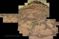
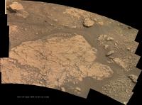
However, the first potential drill site candidate appears to be in the lighter toned bedrocks seen in the arm workspace on sol 2700.
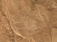
Attached is a mosaic of the L-MastCam images of that workspace, I believe the https://mars.nasa.gov/msl/mission-updates/8627/sols-2701-2702-approaching-a-possible-drill-target/is the Trapezoid shaped block in the upper right of the mosaic.
|
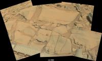
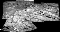
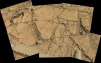
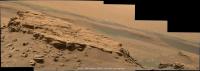
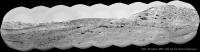
Posted by: PaulH51 Mar 13 2020, 11:15 AM
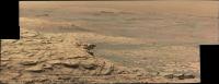
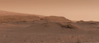
Looking towards the edge of the Greenheugh Pediment and some rather nice strata seen in this R-Mastcam partial pan from sol 2700, debayered in GIMP and stitched using MS-ICE, no additional processing, so apologies for the green hue as I can't find a way of removing it.
|
Posted by: jvandriel Mar 13 2020, 01:56 PM
The Navcam L view on Sol 2700.
Jan van Driel
|
Posted by: Ant103 Mar 13 2020, 04:17 PM
Sol 2700 loooooooooooooooooooooooooooooooooooong Mastcam100 mosaic showing a hell of details there.
http://www.db-prods.net/marsroversimages/curiosity-2020.php#4
Posted by: jvandriel Mar 14 2020, 03:00 PM
The Navcam L view on Sol 2702.
Jan van Driel
|
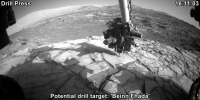
Posted by: PaulH51 Mar 15 2020, 03:34 AM
Sol 2703 animated GIF showing the pre-drill (load test) of the potential drill target: 'Beinn Fhada'
Reduced to 800x400px
|
Posted by: jvandriel Mar 15 2020, 02:56 PM
The Navcam L view on Sol 2702-2703.
Added 5 images taken on Sol 2703.
Jan van Driel
|
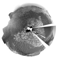
Posted by: Phil Stooke Mar 16 2020, 02:46 AM
Jan's newest panorama in circular format:
|
Phil
Posted by: jvandriel Mar 17 2020, 03:46 PM
The Mastcam L view on Sol 2699.
Jan van Driel
|
Posted by: jvandriel Mar 18 2020, 11:15 AM
The Mastcam L view on Sol 2700.
Jan van Driel
|
|
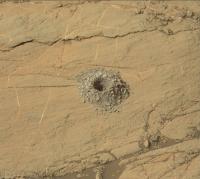
Posted by: PaulH51 Mar 23 2020, 01:15 PM
Edinburgh drill hole on sol 2711, judging by the HazCam images acquired during drilling and the tailings shown in this L-NavCam frame there should be a good chance of a viable sample in the sleeve
|
Posted by: Phil Stooke Mar 24 2020, 06:32 PM
Yes, the hole looks good!
|
Phil
Posted by: jvandriel Mar 25 2020, 09:57 AM
Partial view of the Mastcam L view on Sol 2711.
Jan van Driel
|
Posted by: atomoid Mar 25 2020, 06:51 PM
Thank you for that nicely debayered and stitched pano of the sol2711 mastcam set. Its quite a view and am especially intrigued by highly eroded sections especially as seen in the snippet of the pano below, representing https://mars.nasa.gov/raw_images/793249/?site=msl of https://mars.nasa.gov/raw_images/793247/?site=msl, looking closer a sinuous curve of apparent eroded pediment boundary appears sharply shadowed appearing in the exposure as if it were some sort of slack cable draped over the landscape. I keep losing my bearing as to where we are so have no idea if Curi is heading towards that particular area or onward elsewhere..

|
|
Posted by: fredk Mar 25 2020, 08:27 PM
We had this MR view of that feature, though with a bit different lighting:
https://mars.nasa.gov/msl-raw-images/msss/02700/mcam/2700MR0141340180405167C00_DXXX.jpg
Posted by: PaulH51 Mar 26 2020, 01:06 PM
Sol 2713 GIF: Sample drop for 'portion characterisation' in this cropped L-MastCam of the powdered rock from the 'Edinburgh' drill site.
|
Posted by: PaulH51 Mar 27 2020, 11:38 AM
A long distance 10 frame ChemCam-RMI mosaic of what I believe is a face of Gediz Vallis Ridge, images acquired on sol 2715. Roughly assembled in MS-ICE and annotated, but otherwise unprocessed.
|
|
Posted by: PaulH51 Mar 27 2020, 12:11 PM
Another long distance ChemCam-RMI Mosaic, possibly a basal section of the Gediz Vallis Ridge a little closer to the rover?
Once again from sol 2715, roughly assembled in MS-ICE without additional processing
|
|
Posted by: Ant103 Mar 28 2020, 11:06 AM
Sol 2711 Mastcam34 panoramic. This is such a beautiful place
http://www.db-prods.net/marsroversimages/curiosity-2020.php#6
Postcard version :
http://www.db-prods.net/blog/2020/03/28/curiosity-at-greenheugh/
Posted by: PaulH51 Mar 31 2020, 07:39 AM
Lovely work Damia, looking forward to seeing more of your excellent panoramas!
Meanwhile, another long distance RMI mosaic across the pediment, this time wider view (19 frames from sol 2719) It was roughly assembled in MS-ICE without additional processing.
|
|
Posted by: atomoid Mar 31 2020, 08:16 PM
Indeed a very lovely view, the composition gives a feeling almost of a Martian sort of tropical, taking in a relatively balmy afternoon as wavelets of sand gently lap up against the near shore and relax sipping a perchlorate cocktail under the instrument cluster standing in as mock parasol, take a glance over near to the right a bit into the distance many barchan dune islands poke above the surface as the seas of sand grow rougher dissappearing into the murky distance, in splendid isolation I will be to remain here for some while..
Posted by: eliBonora Apr 1 2020, 08:02 AM
Another version of sol 2711 panorama (de-bayer)
https://flic.kr/p/2iKuNSw
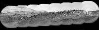
Posted by: PaulH51 Apr 6 2020, 07:48 AM
Yet another long range ChemCam RMI mosaic checking the distant terrain, this one appears to focus on the hills beyond the Greenheugh Pediment. Images from Sol 2725, composed of 12 frames assembled in MS-ICE without further processing. Note, there appears to be 14 images in this sequence, but one processed frame has not made it to the server as of the time of this post.
|
|
Posted by: serpens Apr 6 2020, 08:09 AM
I may be a tad bidirectionally challenged, but isn't that the marker bed?
Posted by: PaulH51 Apr 6 2020, 11:30 AM
I'm not sure, but I'm guessing you are referring to the 'marker bed' described in this? https://pdfs.semanticscholar.org/6360/df4793f892ae402db008af44d197e73d5ca0.pdf
Here's where I think the terrain is, I've added a box to a mosaic assemble by Neville Thomson showing the other long range RMIs from atop the pediment https://flic.kr/p/2iMaT3r
|
|
Edit: We now have the mission update that covers this sol:
Posted by: charborob Apr 6 2020, 04:12 PM
Two long-distance RMI panoramas taken on sol 2723:
|
|
|
|
Posted by: PaulH51 Apr 7 2020, 09:30 AM
Here's a little more detail in this telephoto ChemCam-RMI from Sol 2726, roughly assembled in MS-ICE, some data drop out in one frame. No additional processing except the stitch and adding the text.
|
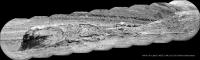
Posted by: PaulH51 Apr 9 2020, 01:24 PM
Yet another long range RMI mosaic, I can't recall so many of these being acquired from one location.
This one is from Sol 2728, assembled in MS-ICE
|
Posted by: charborob Apr 9 2020, 03:34 PM
Two long-range RMI mosaics taken on sol 2726:
|
|
Posted by: charborob Apr 9 2020, 03:45 PM
A second long-range RMI mosaic from sol 2728:
|
Posted by: Ant103 Apr 10 2020, 10:47 AM
Quoting myself because this panorama is finally over. I missed one frame to complete it, and this frame was available tonight. So
http://www.db-prods.net/marsroversimages/curiosity-2020.php#4
Posted by: phase4 Apr 11 2020, 12:09 AM
new navcams! and why not view them in the latest version of my navcam viewer?
https://captainvideo.nl/rob/navcamdiary.html
press tab or the topright circle for a sol list
press h for other options
stay safe, all of you!
Posted by: charborob Apr 11 2020, 12:59 AM
Sol 2729 long-range RMI mosaic:
|
|
Posted by: HSchirmer Apr 11 2020, 01:50 AM
|
|
Do we have another "spoon" of suspended rock in that RMI?
Like what we saw around Sol 1070-1089?
|
Posted by: neo56 Apr 11 2020, 12:06 PM
Here is my take on the huge MC100 panorama, http://www.gigapan.com/gigapans/220269:
https://flic.kr/p/2iPbrBg
Posted by: jvandriel Apr 11 2020, 01:11 PM
The Navcam L view on Sol 2729.
Jan van Driel

|
Posted by: Phil Stooke Apr 11 2020, 06:29 PM
Thanks, Jan. Here is a circular view of it showing how we have moved away from the edge of that depression. The recent updates have indicated we will drive off the pediment and resume the previous path around its edge to the east, then up into the hills.
Phil
|
Posted by: jvandriel Apr 13 2020, 01:58 PM
The Mastcam L view on Sol 2729.
Jan van Driel
|
Posted by: jvandriel Apr 13 2020, 06:03 PM
The Navcam L view on Sol 2732.
Jan van Driel

|
Posted by: neo56 Apr 14 2020, 03:33 PM
My take on the MastCam Right mosaic of sol 2729, with 5 extra Matt Damon added to give a scale 
The furthest one is at ~580m from Curiosity rover.
https://flic.kr/p/2iQjswp
Posted by: Phil Stooke Apr 14 2020, 08:35 PM
Don't jump, Matt! There's still hope for a sequel!
Also, here is Jan's new panorama in circular form. We have moved right to the edge of the pediment again at the same place we climbed it earlier. The tracks are visible just below us.
Phil
|
Posted by: serpens Apr 14 2020, 10:09 PM
Found Wally. Thanks for the humour neo.
Posted by: atomoid Apr 15 2020, 12:22 AM
Thanks neo56 for the great image treatment, i inspected jvandiel's stitch of the same sequence yesterday and was frustrated trying to get a handle on the scale of things, and since i tend to overestimate the scale of things in the near-scope pancams, i now see im overcompensating for the larger scale sequences, i so misunderestimated that protruding part of the rock to be only about the size of Mark Watney's boot, off by over 3x..
Posted by: jvandriel Apr 15 2020, 06:43 PM
The Navcam L view on Sol 2734.
Jan van Driel

|
Posted by: Phil Stooke Apr 15 2020, 08:16 PM
Right off the pediment! We ended up just about at the sol 2658 location - get those brakes checked, Curiosity! The map may be delayed a day or two because people won't leave the Moon alone.
Jan's panorama in circular form.
This thread might have to be renamed 'Around the Greenheugh Pediment' because that's where we will be going now.
Phil
|
Posted by: nprev Apr 16 2020, 02:50 AM
Topic title edited to reflect circumstances.
Posted by: jvandriel Apr 17 2020, 03:17 PM
The Navcam L view on Sol 2736.
Jan van Driel
|
Posted by: jvandriel Apr 17 2020, 04:29 PM
added 2 images to complete the view.
Jan van Driel
|
Posted by: charborob Apr 22 2020, 11:19 PM
Sol 2741 long-range RMI:
|
|
Posted by: monty python Apr 23 2020, 07:43 AM
An uncomformity.
Posted by: jvandriel Apr 24 2020, 09:32 AM
The MASTCam R Animation on Sol 2740.
Jan van Driel
|
Posted by: neo56 Apr 25 2020, 01:10 PM
Curiosity rover bypassing Tower Butte on sol 2742:
https://flic.kr/p/2iUbttn
Posted by: jvandriel Apr 26 2020, 01:20 PM
The Navcam L view on Sol 2742-2743.
Jan van Driel
|
Posted by: Julius Apr 27 2020, 01:04 PM
Was it always planned for the rover to descend off the pediment back onto the clay unit or did I miss something?
Posted by: jvandriel Apr 27 2020, 01:58 PM
The Navcam L view on Sol 2745.
Jan van Driel
|
Posted by: Phil Stooke Apr 27 2020, 08:16 PM
Here is Jan's panorama for sol 2745 in circular form. A nice view of the two buttes nearby.
Phil
|
Posted by: mcaplinger Apr 27 2020, 10:13 PM
AFAIK this was always the plan, but I'm not sure if it was explicitly said or just somewhat implied in the status reports.
See https://mars.nasa.gov/msl/mission-updates/8656/sols-2744-2746-goodbye-to-the-pediment-for-now/ and note the use of the phrase "mini campaign".
Posted by: Phil Stooke Apr 27 2020, 10:38 PM
One of the most important targets of the entire mission is the contact between the clay unit in Glen Torridon and the sulfate hills above it, which is assumed to mark a major change in global climate from (let's call it) moist to arid. The Pediment straddles that contact, so if you stay on it you have missed the crucial exposures. They went up because it was possible at that location, so why not have a quick look at it in case a failure ends the mission before they meet it again higher up the mountain.
This LPSC abstract shows the planned path ahead, as of just a few months ago.
https://www.hou.usra.edu/meetings/lpsc2020/pdf/2426.pdf
Phil
Posted by: PaulH51 Apr 28 2020, 12:59 AM
Phil
Does anyone know if the figures from this abstract are available at a higher resolution? Maybe in another document, or a large poster?
I'm particularly interested in Fig1 that shows the MSAR version 9 or later
It would be nice to see the detail of the proposed path around the pediment up to the sulfate hills
Posted by: atomoid Apr 28 2020, 05:55 AM
One approach is to use the https://www.uahirise.org/hiwish/browse search for Gale and zoom into the Gedis Valles area and pan and poke around through the madly overlapping needles in that haystack to find the good views https://hirise-pds.lpl.arizona.edu/PDS/EXTRAS/RDR/ESP/ORB_053700_053799/ESP_053732_1750/ESP_053732_1750_MRGB.abrowse.jpg. some of that area was also in the 50th https://www.hou.usra.edu/meetings/lpsc2019/pdf/3196.pdf
Posted by: Phil Stooke Apr 28 2020, 06:29 AM
Paul:
"It would be nice to see the detail of the proposed path around the pediment up to the sulfate hills"
That image will stand quite a lot of enlargement. I don't know a better source yet.
Phil
Posted by: PaulH51 Apr 28 2020, 07:29 AM
Cheers, I'll give that a go
Posted by: neo56 Apr 30 2020, 07:58 AM
Anaglyph of NavCam pictures of Tower Butte on sol 2742:
https://flic.kr/p/2iVSUQN
Posted by: jvandriel Apr 30 2020, 08:41 AM
The NAVcam L view on Sol 2747.
Jan van Driel
|
Posted by: PaulH51 May 1 2020, 10:24 AM
9 R-MastCam frames, possibly featuring 'Glasgow'. Images from sol 2747, roughly assembled into a simple mosaic using MS-ICE (no additional processing)
|
Posted by: jvandriel May 1 2020, 08:09 PM
The NAVcam R view on Sol 2749.
Jan van Driel
|
|
Posted by: PaulH51 May 3 2020, 07:54 AM
Front hazcam GIF of the planned drill press at the Glasgow drill site (Sol 2749)
|
Posted by: jvandriel May 3 2020, 03:13 PM
The MASTcam L view on Sol 2744.
Jan van Driel
|
Posted by: jvandriel May 5 2020, 01:20 PM
The Mastcam L view on Sol 2751.
Jan van Driel
|
|
Posted by: Phil Stooke May 6 2020, 08:27 PM
A successful drill, by the look of the Hazcams. I won't post an image as much better ones will be coming soon.
Phil
Posted by: jvandriel May 7 2020, 01:48 PM
Sol 2754
Drilling seen by the FrontHazcam
Jan van Driel
|
Posted by: PaulH51 May 7 2020, 01:48 PM
Here you go Phil (R-MastCam of Glasgow - Sol 2754)
|
Posted by: jvandriel May 8 2020, 02:07 PM
The MASTcam L view on Sol 2750.
Jan van Driel
|
Posted by: neo56 May 8 2020, 08:03 PM
I managed to build a depth map using the stereo pair of NavCam pictures of Tower Butte taken on sol 2742.
Using Wiggle Maker, a website made by Ugo Capeto, I was able to create this "wiggle" view of Tower Butte, with the same kind of effect we can find on Facebook 3D.
|
I also included Matt Damon from The Martian to better grasp the height of the butte:
https://flic.kr/p/2iYVXji
Posted by: charborob May 11 2020, 03:59 PM
Sol 2757 RMI:
|
|
Posted by: serpens May 12 2020, 12:37 AM
I can see why they termed it nodular.
Posted by: PaulH51 May 13 2020, 05:47 AM
10 frame RMI mosaic across Grimbister on sol 2761
Roughly assembled in MS-ICE
|
Posted by: PaulH51 May 25 2020, 09:07 AM
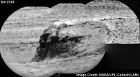
Sol 2772: ChemCam-RMI mosaic of what looks like a complex (multi event?) erosion resistant mineral filled fracture
Image Credit: NASA/JPL-Caltech/LANL

|
Posted by: Ant103 May 27 2020, 09:49 AM
Hey, could you help me ?
On Sol 2767, Curiosity took a very odd image. I've just unbayer it, so we can see that it was taken under blue filter. Given the time at this location, it was during the night.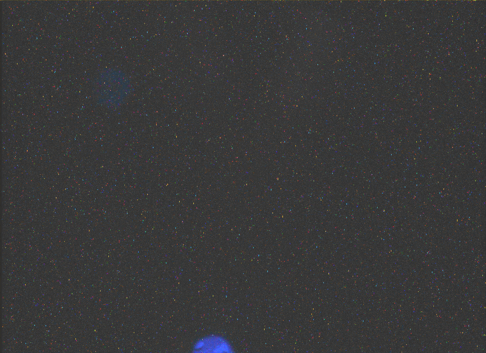
An other pic, cropped and a bit cleaned up.
Problem is, I don't have any clue of what is that object. Could be Phobos, but after a simulation in Stellarium, this moon was just setting. And Deimos is too small to be picture with such resolution. But maybe Stellarium wasn't very accurate about the exact location of Phobos in the sky. So, I don't know
Posted by: Deimos May 27 2020, 02:01 PM
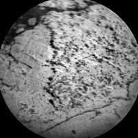
That looks like a mid-morning image [*] through the solar filter taken as part of a dark current measurement. I'd expect the image aim to be at nearby ground. It would be a very long exposure--typically they are a set of 0-sec, short, and long exposures. The solar filter transmits ~0.001% of incident light, but the one in M-100 has a couple scratches or pinhole defects that let light into the system. And yes, the artifacts are blue because the M-100 solar filter is paired with a 440-nm, narrow-band filter.
The artifacts have been around since the start of the mission. Sun images are designed to miss them--at least they are conveniently off-center. See also: Bell et al 2017 (https://agupubs.onlinelibrary.wiley.com/doi/full/10.1002/2016EA000219) section 4.2.7 (pinhole) and 4.2.1 (dark measurements).
* I see just after midnight UTC, which is a bit before 9 AM that sol.
Posted by: fredk May 27 2020, 06:03 PM
Yeah, we don't have the LMST publicly yet for that image (without calculating it ourselves of course), but it was taken at around 0:29 UT, which is only a few minutes before this image was taken, which is clearly daytime:
https://mars.nasa.gov/msl-raw-images/msss/02767/mcam/2767MR0144940011202028C00_DXXX.jpg
Posted by: Ant103 May 28 2020, 10:51 AM
Thank you both for your answers
It explains
A LOT actually. I suspected something like this but I was like "Come on ! A hole in a solar filter ? Makes no sense !". I was wrong
As for my Stellarium simulation, I don't understand where I made a mistake. I input the correct location, the correct time, and this gave me nighttime. Not daytime. I should dig deeper to find where I made a mistake
But again, thank you
Posted by: Phil Stooke May 28 2020, 09:22 PM
A bit quiet lately as Curiosity digests its Glasgow lunch. This shows where and when a few events happened:
|
I should point out that my 'sample dumps' include the sprinkling of small amounts of material as well as the bigger dump on the last sol.
Now it's time to get moving again.
Phil
Posted by: neo56 May 30 2020, 10:07 PM
Back to the RMI observations of Gediz Vallis Ridge: I eventually finished stitching together several RMI sets and colorized them with MC Right pictures. More mosaics to come!
https://flic.kr/p/2j7dcfP
https://flic.kr/p/2j7joaV
Posted by: PaulH51 Jun 1 2020, 10:17 PM
Drive on Sol 2780: Partial pan (L-NavCam), roughly assembled in MS-ICE
|
Posted by: Phil Stooke Jun 3 2020, 02:47 AM
This is Paul's partial panorama reprojected - this is what gave me the position on the map which should be pretty good. Today, sol 2781, we drove again.
Phil
|
Posted by: PaulH51 Jun 3 2020, 04:26 AM
Another drive, this time on Sol 2781: Partial pan (L-NavCam), roughly assembled in MS-ICE.
Some exposure issues caused by lighting, but it may help Phil get a position until someone can stitch it properly
|
Posted by: Phil Stooke Jun 3 2020, 07:05 AM
Thanks, Paul - I threw in an extra image. Here is a circular version. We moved about 50 m east.
Phil
|
Posted by: jvandriel Jun 3 2020, 01:03 PM
The Navcam L view on Sol 2781.
Jan van Driel
|
Posted by: jvandriel Jun 3 2020, 07:17 PM
The Navcam L-R view on Sol 2781.
Added 3 images taken with the Right Navcam.
Jan van Driel
|
Posted by: Phil Stooke Jun 4 2020, 02:45 AM
Thanks, Jan. I used the composite image to make a circular view - my orientation was a bit off with the earlier one from Paul. We will be weaving between dark sand patches for quite a while along this path.
Phil
|
Posted by: jvandriel Jun 5 2020, 12:54 PM
The Navcam L view on Sol 2783.
Jan van Driel
|
Posted by: Phil Stooke Jun 5 2020, 11:10 PM
Very nice, Jan. Here is a circular projection of it showing the location relative to these dark sandy patches.
Phil
|
Posted by: jvandriel Jun 7 2020, 05:51 PM
The MASTcam L view on Sol 2784.
Jan van Driel
|
|
Posted by: jvandriel Jun 8 2020, 05:54 PM
The Navcam L view on Sol 2786.
Jan van Driel
|
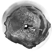
Posted by: Phil Stooke Jun 8 2020, 11:06 PM
Thanks, Jan. This drive was about 60 m northeast through a gap in the dark sandy patches. Here's a circular projection to show the new location.
Phil
|
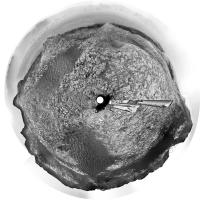
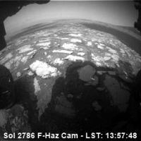
Posted by: PaulH51 Jun 9 2020, 01:16 AM
Here's a small (256x256) animated GIF of the Sol 2786 drive between the sand patches mentioned by Phil. The 14 frames were acquired with the front left hazcam. The sequence concludes with the a look back towards the setting sun and the path the rover had taken. The local timestamps are taken from JSON.
|
Posted by: PaulH51 Jun 10 2020, 05:48 AM
Sol 2788: Left navigation camera partial pan after another drive, roughly assembled in MS-ICE, but hopefully it can be used to provide a rough location until the rest of the images are downlinked

|
Posted by: jvandriel Jun 10 2020, 11:41 AM
The Navcam L view on Sol 2788.
Jan van Driel
|
Posted by: Phil Stooke Jun 10 2020, 05:40 PM
Thanks, Jan. Here is a circular version.
|
When compared with HiRISE images for my map, this shows a very good drive of about 80 m to the east, ending below a big elongated butte almost separated from the pediment. A rubble-covered patch thought to be a landslide deposit off the slope of the butte is just southeast of the rover.
Phil
Posted by: neo56 Jun 12 2020, 07:06 PM
I made this animation using two RMI mosaics taken respectively on sol 2295 and 2726. It provides really different points of view on this cliff located 1,2 km South-East from the rover:
https://live.staticflickr.com/65535/49999305087_f14aebef4d_o.gif
Posted by: Phil Stooke Jun 12 2020, 10:40 PM
That's really nice!
Not much to go on yet for the sol 2790 drive, but the hazcams are enough for a pretty good estimate (usually they are not so helpful).
Here's a projected version of a front-rear pair.
Phil
|
Posted by: jvandriel Jun 13 2020, 02:07 PM
The Navcam L view on Sol 2790-2791.
Jan van Driel
|
Posted by: Phil Stooke Jun 13 2020, 08:25 PM
Much better than the Hazcam version! Thanks, Jan.
Phil
|
Posted by: neo56 Jun 14 2020, 01:21 PM
I made two photomontages to show RMI mosaics (sol 2295 and sol 2726) into a wider context provided by MastCam 100mm.
The featured steep cliff is about 10m high. To better grasp its scale, I added Matt Damon from the Martian movie and Curiosity rover itself.
I also added the Statue of Liberty in another photomontage to grasp the scale of the background 100m high hill.
https://flic.kr/p/2jbtwFZ
https://flic.kr/p/2jbqjgg
https://flic.kr/p/2jbqQWu
https://flic.kr/p/2jbtacg
https://flic.kr/p/2jbvpFu
https://flic.kr/p/2jbAqCi
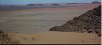
Posted by: Sean Jun 15 2020, 10:54 AM
Here is a drone's eye view of the landscape of the route ahead, with Sol 2793 approximate location in the lower right...
https://flic.kr/p/2jc74Nn
made from my Sketchfab https://skfb.ly/68HnC model of the region
Posted by: jvandriel Jun 15 2020, 12:56 PM
The Navcam L view on Sol 2793.
Jan van Driel

|
Posted by: neo56 Jun 15 2020, 04:45 PM
Nice view Sean! Do you have a view that extend further south, down to the hills and Gediz Vallis Channel?
Posted by: Phil Stooke Jun 15 2020, 04:54 PM
That is really nice, Sean.
Phil
Posted by: Phil Stooke Jun 15 2020, 05:31 PM
And Jan's panorama is nice too. Here is a circular version, and we have moved around the north end of that irregular patch of dark sand.
Phil

|
Posted by: Sean Jun 15 2020, 06:01 PM
The Sketchfab model covers that area and if you have VR the avatar position is located at the mouth of the channel.
Posted by: neo56 Jun 15 2020, 06:45 PM
Yes, I checked on your Sketchfab but I'm looking for a model covering a much wider area further south like on this Google Earth view:

|
Posted by: atomoid Jun 15 2020, 11:18 PM
I concur it would be great to have a model going up the channel further to see where we may end up just a few years from now, im guessing that creating the model probably represents countless hours of sweat over aligning stitching blending and retweaking into the wee hours of the morning, getting it to optimize for loading into sketchfab was probably another strain in itself.. so its already greatly appreciated, and i just love flying around in it to get that sense of 'location', but of course more is always better!
neo56 excellent post of RMI context with statue of liberty inset, i would have tilted it halfway buried with Charlton Heston pounding the sand: "Damn you all.....
Posted by: Sean Jun 16 2020, 01:21 AM
I've got all the Gale DTM's aligned in 3D but its an old project and I am keen to revisit soon for a full overhaul & update. I will upload the channel region to Sketchfab once I disentangle my archive.
Here is a https://youtu.be/grk5Y4SrBaU flying down the channel.
Another view at the end of this https://youtu.be/Kl0rMclxDL4
I'll also quickly plug a recent film I made by re-jigging some of my old HiRISE clips...
https://flic.kr/p/2j7voLf
Here it is on https://youtu.be/m_geeog42mk
Gale clips at 8:24 to 11:44 / 17:15 to 22:00
Posted by: antipode Jun 16 2020, 07:28 AM
Absolutely stunning. Mesmerising. And perfect music too.
Congratulations. I will go back to this time and again...
P
ps I especially liked the flyover of the glacier. Err sorry 'glacier-like form' cough.
Can you tell me where the mountainous terrain at 28 minutes is? Is that on the edge of Argyre?
Posted by: Sean Jun 16 2020, 09:51 AM
Congratulations. I will go back to this time and again...
P
ps I especially liked the flyover of the glacier. Err sorry 'glacier-like form' cough.
Can you tell me where the mountainous terrain at 28 minutes is? Is that on the edge of Argyre?
That is the center of Hale Crater. ( 2x dtm's )
Posted by: nogal Jun 16 2020, 06:34 PM
You spoil us Sean! (I don't mind )
Seeing the movie and contrasting it with the latest notional route is an interesting exercise.
Those loops around the central hills near the mound look quite difficult ... Notional the route is.
Fernando
Posted by: Sean Jun 16 2020, 08:22 PM
Context for Gediz Vallis Channel and current position in the lower right of the frame.
https://flic.kr/p/2jcvqHo
From http://www.gigapan.com/gigapans/196659
9x dtm augmented with CTX & HRSC
https://flic.kr/p/2jczBGZ
Posted by: Art Martin Jun 16 2020, 11:14 PM
Been awhile since we've had the really dramatic views that so called for an anaglyph and it's only going to get better.
https://flic.kr/p/2jcAoFahttps://flic.kr/p/2jcAoFa
Posted by: neo56 Jun 17 2020, 04:15 PM
Stunning work Sean! I particularly appreciate the gigapan version. I'm looking forward an updated 3D model once you have time to do it!
Posted by: neo56 Jun 17 2020, 07:51 PM
Mosaic of 3 NavCam Right pictures taken on sol 2795 at 5:20 pm local time:
https://flic.kr/p/2jcQ49w
And the anaglyph:
https://flic.kr/p/2jcQXcQ
Posted by: Phil Stooke Jun 18 2020, 02:15 AM
This is a Mastcam image from sol 45, during the drive to Yellowknife Bay. Bloodstone Hill is shown by the arrow.
Phil
|
Posted by: neo56 Jun 18 2020, 04:15 PM
I added Matt Damon on top of Bloodstone Hill to better grasp the scale of the landscape. That hill is about 10m high and 35m from the rover.
https://flic.kr/p/2jcZsC3
Posted by: neo56 Jun 18 2020, 06:37 PM
A dream coming true...
When I was a kid, I gazed at Mars Pathfinder pictures dreaming about the view we would see if Sojourner had ever driven on Twin Peaks.
Then Spirit climbed to the top of Husband Hill and Opportunity reached the top of Endeavour crater wall, unveiling marvelous vistas.
I always loved hiking! Pictures taken by Curiosity these days and in a not so far future provide, in my opinion, an even more exciting experience of martian hiking.
What a great period of exploration we live in!
https://flic.kr/p/2jd4iQg
Posted by: palebutdot Jun 18 2020, 07:35 PM
Source Images
https://mars.nasa.gov/raw_images/821492/
https://mars.nasa.gov/raw_images/821494/
Posted by: Phil Stooke Jun 18 2020, 07:42 PM
Beautiful work from everyone! What an amazing place this is.
Phil
Posted by: jvandriel Jun 18 2020, 08:00 PM
The Navcam L view on Sol 2795-2796.
Jan van Driel
|
Posted by: Phil Stooke Jun 18 2020, 10:46 PM
Jan's panorama in circular form. I will have to modify my position on the map a little bit - it was based on only the first few images.
Phil
|
Posted by: Phil Stooke Jun 22 2020, 11:46 PM
Sol 2800, a small move to increase stability before using the arm. It looks like just a couple of meters downhill, north, pretty much back along the tracks. I will not update the map for this.
Phil
Posted by: charborob Jun 23 2020, 01:28 AM
Sol 2797 Rmastcam:
|
|
Posted by: jvandriel Jun 23 2020, 02:55 PM
The Navcam L view on Sol 2800.
Jan van Driel
|
Posted by: Phil Stooke Jun 24 2020, 06:35 AM
A circular projection of Jan's panorama.
Phil
|
Posted by: palebutdot Jun 24 2020, 06:49 PM
Tracks made this Monday on Mars by NASA's Curiosity rover
https://mars.nasa.gov/raw_images/823567/
|
Posted by: PaulH51 Jun 25 2020, 02:11 AM
The stitching of this L-NavCam partial pan is rather poor, but it may assist in narrowing down the location after a drive on sol 2802. but it's a nice look back at Bloodstone Hill as the rover returns to the path that will take it to the Sulfate unit. Looking forward to Jan's version
|
Posted by: neo56 Jun 25 2020, 07:13 AM
Mosaic of 3 NavCam Right pictures taken on sol 2802 (24 June 2020) at 3:20 pm local time:
https://flic.kr/p/2jf8fTY
Posted by: jvandriel Jun 25 2020, 09:54 AM
Paul,
here's the Sol 2802 Navcam L panorama.
Jan

|
Posted by: PaulH51 Jun 25 2020, 10:16 AM
Perfect
Posted by: neo56 Jun 25 2020, 01:55 PM
Mosaic taken by NavCam Right, with Matt Damon(s) added for scale and an anaglyph. There is a good feeling of 3D here.
https://flic.kr/p/2jfcdxN
https://flic.kr/p/2jf9miA
https://flic.kr/p/2jfcdAD
Posted by: Art Martin Jun 25 2020, 03:48 PM
https://flic.kr/p/2jfcdxN
https://flic.kr/p/2jf9miA
https://flic.kr/p/2jfcdAD
What's unbelievable to me is these are still the "small" hills. The ones at the base of the mountain are massive in comparison.
Posted by: Phil Stooke Jun 25 2020, 09:18 PM
Here is Jan's panorama in circular form. We will be heading to the right, and that's a choppy sea of rock ahead.
Phil

|
Posted by: jvandriel Jun 26 2020, 10:06 AM
The Navcam L view on Sol 2804.
Jan van Driel

|
Posted by: Phil Stooke Jun 26 2020, 08:20 PM
Thanks, Jan. This is a circular version of your panorama. Looks like we will be here for a few days for some software updates etc., giving me a chance to catch up with some Mars 2020 stuff.
Phil

|
Posted by: neo56 Jun 28 2020, 08:49 AM
A piece of panorama on sol 2804 with NavCam Right.
https://flic.kr/p/2jfzcAy
And the anaglyph version:
https://flic.kr/p/2jgAzTY
Posted by: palebutdot Jul 2 2020, 11:05 AM
Sol 2803 Dust Devil:
https://mars.nasa.gov/raw_images/825142/
Posted by: fredk Jul 2 2020, 03:33 PM
Nice catch. Here's a differenced/stretched/added version: 2803_nrb_dd_diff_add.mp4 ( 1.04MB )
: 888
2803_nrb_dd_diff_add.mp4 ( 1.04MB )
: 888
Edit: it seems with firefox you may need to save the file and then play it in a standalone player.
Posted by: Phil Stooke Jul 2 2020, 06:40 PM
Very nice! This is a set of seven difference images - one image merged with the negative (inverted gray scale) of another to show changes.
I take one image, then the next, invert one and merge it with the other. That produces a very bland image so the result is very heavily stretched in contrast. A moving feature will be a composite of a dark object and a bright one - a bit complicated, I know. In the lower row that image is laid over the original view of the scene to help locate features. This is just the last seven image pairs from the sequence.
The biggest feature is a DD blowing across Glen Torridon, but another can be seen in the distance to the middle left, behind Vera Rubin Ridge. At far left in the last few frames a more distant DD is near the Bagnold Dunes.
Phil
|
|
Posted by: jvandriel Jul 3 2020, 08:10 AM
Mastcam R view on Sol 2801.
Jan van Driel

|
Posted by: PaulH51 Jul 3 2020, 01:22 PM
ChemCam mosaic from Sol 2811 (raw) roughly assembled in MS-ICE

|
Posted by: jvandriel Jul 3 2020, 07:39 PM
The MASTcam R view on Sol 2799.
The original pano is 118 MB and consists of 337 images.
Jan van Driel

|
Posted by: charborob Jul 3 2020, 11:54 PM
The original pano is 118 MB and consists of 337 images.
Jan van Driel
I admire your perseverance (pun intended) in downloading and deBayering such a big lot of images. Do you have to deBayer them one by one, or do you have a batch process?
Posted by: jvandriel Jul 5 2020, 08:59 AM
charborob,
thanks for your admiration.
I batch download the images from the JPL website and deBayer them one by one. ( 9 mousecliks per image)
In GIMP there is a batch process for deBayering the images but it produces only black and white images.
I don't know what is wrong. I am still working on that.
Jan
Posted by: Sean Jul 5 2020, 11:11 AM
thanks for your admiration.
I batch download the images from the JPL website and deBayer them one by one. ( 9 mousecliks per image)
In GIMP there is a batch process for deBayering the images but it produces only black and white images.
I don't know what is wrong. I am still working on that.
Jan
Try changing the image mode to rgb before debayering
Posted by: vikingmars Jul 5 2020, 06:02 PM
Sol 2812 : the atmosphere is visually becoming more dusty

|

|
Posted by: charborob Jul 5 2020, 07:31 PM
thanks for your admiration.
I batch download the images from the JPL website and deBayer them one by one. ( 9 mousecliks per image)
In GIMP there is a batch process for deBayering the images but it produces only black and white images.
I don't know what is wrong. I am still working on that.
Jan
I also use Gimp to deBayer the images one by one, but it becomes fastidious and time-consuming when you have many of them.
Posted by: PaulH51 Jul 6 2020, 02:22 AM
sol 2813 L-NavCam pan: Roughly stitched in MS-ICE, can't wait to see the refined version. The view from this location is stunning...

|
Posted by: jvandriel Jul 6 2020, 11:53 AM
The Navcam L view on Sol 2813.

|
Sean,
GIMP is already in RGB mode before deBayering.
I think there is a bug in the process.
Jan
Posted by: Phil Stooke Jul 6 2020, 11:34 PM
Jan's panorama in circular form.
Phil

|
Posted by: phase4 Jul 7 2020, 12:13 AM
Indeed, you can see the horizon disappear.

|
Posted by: PaulH51 Jul 7 2020, 07:16 AM
Curiosity's Workspace L-MastCam Sol 2813, bayer reconstruction in GIMP, roughly assembled in MS-ICE.
Reduced to 8000px wide to allow upload.

|
Posted by: jvandriel Jul 7 2020, 02:46 PM
The MASTcam R view on Sol 2804.
Jan van Driel
|
|
Posted by: brellis Jul 9 2020, 08:52 PM
Is there a reason why Mt. Sharp always looks so much lighter in Curiosity's images than the ground nearby? Catching more sunlight?
Posted by: PaulH51 Jul 10 2020, 01:18 AM
If you want the images from sols 2816 & 2817, try using the JSON feed as the raw image server appears to be in need of a reboot as it's stuck on 2815...
Here's a very roughly assembled partial pan (L-NavCam) from 2816 that may assist in estimating the location
|
|
Posted by: PaulH51 Jul 10 2020, 07:38 AM
Another scrape from JSON as the raw server is still down.
Judging by the number of traverse images this could be a long drive.
There were some wicked exposure issues so I roughly hacked what I could and squeezed this out of MS-ICE.
Sol 2817 pan
|
|
Posted by: Phil Stooke Jul 10 2020, 07:00 PM
I am having great difficulty locating the new position using that panorama. Not Paul's fault - it's a complicated terrain. I'll keep trying.
Phil
Posted by: fredk Jul 10 2020, 08:38 PM
Could it be here, based on the two snaking dunes/ridges to the south?

|
Posted by: john_s Jul 10 2020, 09:50 PM
I had independently estimated the same location as Fred.
Posted by: PaulH51 Jul 10 2020, 10:17 PM
If it helps, the latest mission update refers to a drive distance of 102.5 meters
Posted by: Phil Stooke Jul 11 2020, 12:03 AM
Ah yes, thank you. But Dagnabbit, now I have to modify my map base.
Phil
Posted by: PaulH51 Jul 11 2020, 07:09 AM
Sol 2817 (site index: 82, drive index: 938) L-MastCam mosaic of 8 frames that was assembled in MS-ICE after bayer reconstruction in GIMP.
Nice view across the clay unit with a backdrop of the Vera Rubin Ridge.
|
|
Posted by: jvandriel Jul 12 2020, 09:24 AM
The Navcam L view on Sol 2816.
Jan van Driel
|
|
Posted by: jvandriel Jul 12 2020, 11:35 AM
and the view on Sol 2817.
Jan van Driel
|
Posted by: jvandriel Jul 13 2020, 11:40 AM
The Navcam L view on Sol 2820.
Jan van Driel
|
|
Posted by: jvandriel Jul 13 2020, 07:28 PM
The MASTcam L view on Sol 2789.
Jan van Driel
|
Posted by: Yggdrasil Jul 14 2020, 01:24 AM
Thank you so much for posting these images.
I've been experimenting with getting these 360 degree (?) images into a form viewable VR headset by placing them in the middle of the equirectangular format required by the headsets (e.g. 6000 x 3000 pixels), but the image looks warped regardless where I place (and scale it) in the image format I've tried shifting it upwards and downwards, but it still doesn't look right. (See example atttached to this post). Do you have any idea whether I need to stretch the image differently to compansate for differences in projection etc, or place it in a certain position in the equirect for it to be correctly projected?
Any ideas on how to get this right would be very welcome!
|
Posted by: Phil Stooke Jul 14 2020, 06:56 AM
Jan's sol 2020 panorama in circular format.
Phil
|
Posted by: Phil Stooke Jul 15 2020, 03:25 AM
And these are the previous two Navcam panoramas from Jan in circular form.
Phil
sol 2816:
|
sol 2817:
|
Posted by: Sean Jul 15 2020, 11:03 AM
A Navcam portrait of Vera Rubin Ridge on Sol 02820...
https://flic.kr/p/2jmwHaE
Posted by: jvandriel Jul 16 2020, 05:02 PM
Partial view of the Sol 2822 Navcam L panorama.
The rest of the images will be added later.
Jan van Driel
|
Posted by: PaulH51 Jul 17 2020, 06:33 AM
Another quick and dirty stitch from MS-ICE, this time from sol 2824, that may assist in narrowing down the new location (L-NavCam)
|
|
Posted by: jvandriel Jul 17 2020, 11:08 AM
and the complete Sol 2822 NAVcam L view.
Jan van Driel
|
Posted by: jvandriel Jul 17 2020, 12:55 PM
and the NAVcam L view on Sol 2824.
Jan van Driel
|
Posted by: Phil Stooke Jul 17 2020, 08:07 PM
Thanks, Jan. This is the sol 2824 panorama in circular form. I used it to update the map.
Phil
|
Posted by: neo56 Jul 22 2020, 12:12 PM
Mosaic of 3 MastCam Left pictures taken on sol 2826 (18 July) at 12:10 pm martian local time:
https://flic.kr/p/2joJjXG
And an older one taken on sol 2816 (8 July) with MastCam Right at 12:50 pm martian local time:
https://flic.kr/p/2joS4CY
Posted by: jvandriel Jul 22 2020, 05:45 PM
The Navcam L view on Sol 2829.
Jan van Driel
|
Posted by: Phil Stooke Jul 22 2020, 06:27 PM
Jan's panorama in circular form - we moved north about 15 m.
Phil
|
Posted by: djellison Jul 23 2020, 02:46 AM
How's the map.


Posted by: Phil Stooke Jul 23 2020, 06:35 AM
Fine for now - but don't push your luck! If you drive off the edge of the world don't say I didn't warn you.
Phil
Posted by: djellison Jul 23 2020, 06:52 AM
Were probably parked here for some time....then heading back SE. Lucky escape.
Posted by: PaulH51 Jul 23 2020, 01:27 PM
Candidate drill site 'Mozie Law'?
Sol 2829 L-MastCam, quick and dirty stitch of roughly reconstructed compressed bayer images.
EDIT: Now called https://mars.nasa.gov/msl/mission-updates/8720/sols-2831-2835-the-one-where-curiosity-takes-mary-anning-to-mars/
|
Posted by: neo56 Jul 23 2020, 08:06 PM
Panorama taken with MastCam Left on sol 2829 at 2:20 pm martian local time:
https://flic.kr/p/2jp7LUu
And an animation between sols 2826 and 2829 showing the parallax due to a ~20m drive:
|
Posted by: jvandriel Jul 27 2020, 07:24 PM
The MASTcam R view on Sol 2833.
Jan van Driel
|
Posted by: PaulH51 Jul 31 2020, 11:34 AM
A little later than originally planned, but we now have another sample hole on Mars, "Mary Anning" was drilled during sol 2838
Front HazCam animated GIF (reduced in size for upload)
|
Posted by: Phil Stooke Jul 31 2020, 04:54 PM
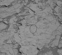
This is part of a MAHLI image from sol 2833. Most of the image is occupied by the DRT brushed area, a bit lighter than its surroundings and surounded by little dust grains. At the middle of it is a little notch pointing roughly in the 5 o'clock to 11 o'clock orientation - that's where the drill tip did a preload test, pushing against the rock to check it was stable enough to drill. It was not present when the DRT was first done earlier that sol.
Phil
|
Posted by: jvandriel Aug 2 2020, 02:26 PM
The MASTcam L view on Sol 2831.
Jan van Driel
|
Posted by: Phil Stooke Aug 3 2020, 05:26 PM
Nice view!
The ellipse in this image shows a cluster of small light-toned particles (plus a few scattered outside the ellipse) from a sample drop on sol 2839.
Phil
|
Posted by: jvandriel Aug 5 2020, 11:21 AM
The MASTcam R view on Sol 2840.
Jan van Driel
|
|
Posted by: Phil Stooke Aug 10 2020, 05:34 PM
Here's a dust devil from the sol 2847 sequence. I make a difference image where a single DD shows up as a pair of features indicating its motion between frames. One of the raw frames is at the bottom, the difference image is at the top, and a composite in the middle. Probably more to come from this sequence.
Phil

|
Posted by: djellison Aug 10 2020, 11:02 PM
Well spotted Phil - It's one of the best I've ever seen. Tried processing from the raw JPGS - lots of noise but it comes out well if you diff it to a mean of the full sequence.
Posted by: John Moore Aug 10 2020, 11:13 PM
Wow, that's super Phil: I wonder is there someone researching relationships between dust-devil heights to surface height contours? Very complex, I would imagine.
John
Posted by: PaulH51 Aug 12 2020, 11:09 AM
A long distance ChemCam RMI mosaic roughly assembled in MS-ICE from 5 overlapping frames from sol 2849.

|
Posted by: Phil Stooke Aug 13 2020, 06:16 AM
There's a bit of dust devil activity on the next sol, 2848, as well. This is a sequence where the whole horizon is imaged with 3 frames per pointing to track dd activity everywhere. The sol 2847 set was one long movie.
Phil

|
Posted by: Phil Stooke Aug 13 2020, 05:03 PM
A bit more on sol 2850 as well, but Curiosity blocked most of the best view with its turret.
Phil
Posted by: PaulH51 Aug 16 2020, 08:41 AM
Really enjoying the DD's
Here's a nice crisp telephoto mosaic assembled from 8 overlapping RMI's, roughly assembled in MS-ICE, without additional processing.
Mission Sol 2853 / August 15, 2020 (I think it's looking South)

|
Posted by: fredk Aug 16 2020, 04:48 PM
Thanks for the mosaic, Paul - I always like the distant chemcam mosaics. The field is to the SE, on the left side of this frame:
https://mars.nasa.gov/msl-raw-images/msss/02829/mcam/2829ML0148140010108764C00_DXXX.jpg
Posted by: PaulH51 Aug 17 2020, 11:41 AM
Many thanks, I can see it now
Hopefully we'll get a closer look at that target area on the path towards the sulfate unit
Posted by: fredk Aug 24 2020, 04:57 PM
Starting around sol 2850 the MSSS images at mars.nasa.gov/msl-raw-images have been provided with incorrect MIME types. This means they won't display correctly in browsers. For example, clicking on this mastcam link:
https://mars.nasa.gov/msl-raw-images/msss/02860/mcam/2860ML0149380631100307C00_DXXX.jpg
browsers will typically ask what you want to do with the file or just download it. Clicking on an engineering pic, eg:
https://mars.nasa.gov/msl-raw-images/proj/msl/redops/ods/surface/sol/02861/opgs/edr/ncam/NRB_651489827EDR_F0822176NCAM00543M_.JPG
will open the image in a new window/tab as it should.
I've sent a message about this at the https://mars.nasa.gov/feedback/, but I'm not sure if there is someone I can contact more directly.
Technical detail: the mars.nasa.gov web server incorrectly sets the response Content-Type header to binary/octet-stream when it should be set to image/jpeg for those MSSS images, so the browser doesn't know what to do with it. This seems to be a problem with AmazonS3 servers when the MIME type isn't provided on upload.
Posted by: Phil Stooke Aug 24 2020, 09:05 PM
Sol 2858: DRT and pre-load test. The DRT brushed patch is outlined by black lines. The notch cut by the drill bit during the pre-load test is shown by white arrows.
Phil

|
Posted by: jvandriel Aug 25 2020, 02:10 PM
The NAVcam L view on Sol 2862.
Jan van Driel

|
Posted by: Paul Marshall Aug 27 2020, 12:05 PM
2853 Right Mastcam plus a few tests building a 3D perspective using both the left/right views.
https://flic.kr/p/2jyywic
https://flic.kr/p/2jyzwkL
https://flic.kr/p/2jyyy6L
Posted by: djellison Aug 27 2020, 09:33 PM
The MSL mosaic page appears to be getting updates again
https://mars.nasa.gov/msl/multimedia/mosaics/
Posted by: fredk Aug 27 2020, 09:59 PM
Good to see those. I guess that should've been 2829, not 2858, for the latest mosaic.
Posted by: djellison Aug 27 2020, 10:34 PM
Any time there is something that isn't a dust devil / cloud survey / documentation image.....then the mosaic gets remade.
In this case - it would have been remade on 2858 with the addition of this workspace image
https://mars.nasa.gov/msl-raw-images/proj/msl/redops/ods/surface/sol/02858/opgs/edr/ncam/NRB_651222545EDR_F0822176NCAM00353M_.JPG
Posted by: jvandriel Aug 28 2020, 01:31 PM
The NAVcam L view on Sol 2865.
( almost the same view as on Sol 2829 and added the images taken
on Sol 2845 and the 5 images at the top taken on Sol 2865 )
Jan van Driel

|
Posted by: PaulH51 Aug 29 2020, 08:13 AM
Sol 2865: There was a https://mars.nasa.gov/msl/mission-updates/8745/sols-2864-2866-spot-the-difference/ planned, but the rover is still at site 82, drive 2176.
Here's the 2865 ML workspace: Slightly different camera pointing compared with the 2829 ML workspace, but looks to me to be the same location?
In this mosaic we have the Mary Anning sample hole, the dump pile of the unused sample, a stowed arm and some subtle changes in the sand ripples between the outcrops.

|
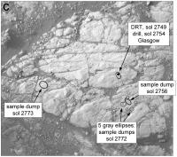
Posted by: Phil Stooke Sep 1 2020, 08:53 PM
Another DRT brushing job at Mary Anning. Here is a map of the rock slab (oriented approximately north-up) showing the activities at this location.
Phil

|
Posted by: Art Martin Sep 2 2020, 02:49 AM
Phil
|
|
Is there something they've found at this particular location that has generated all this time and interest? It sure seems to me that we've done way more sampling of this area than any other.
Posted by: Phil Stooke Sep 2 2020, 03:23 AM
No, Glen Etive was sampled twice and so was another place which slips my mind for a moment. But this place is the best yet for the chemistry analyses:
"Curiosity has been in the area of the Mary Anning targets for a while now, and thats for a very good reason: she came here to find the ideal rocks for a very special SAM experiment (see the blog from sols 2867-2869). First, we confirmed we had the rock-type we desired. Appearance can always deceive (and yes, thats not just for rocks, we all know that!). Chemistry, however, doesnt lie, and ChemCam and APXS have confirmed that we have under the drill what we came for. SAM has confirmed that all procedures are now ready to go. Thus, the big headline today is: We are "go" for drilling the Mary Anning 3 target in this plan and to perform the SAM wet chemistry experiment later this week. "
That is from the latest update:
https://mars.nasa.gov/msl/mission-updates/8747/sols-2870-2871-we-are-go-for-drilling/
Phil
Posted by: CosmicRocker Sep 2 2020, 07:04 AM
Fingers crossed. 
Posted by: PaulH51 Sep 3 2020, 12:59 AM
Looks like we have a nice new sample hole in Mars (sol 2870)
Mary Anning 3?
Animated GIF (reduced format to fit upload limit)

|
Posted by: Phil Stooke Sep 3 2020, 02:47 AM
Yes, Mary Anning 3. Here it is:

|
Phil
Posted by: Phil Stooke Sep 6 2020, 09:27 PM
As noted above, there had been a plan to 'bump' or move slightly on sol 2865 to position the rover better for a drill hole at Mary Anning 2. Looking at the images I can't see any evidence that a bump happened. Then work proceeded at Mary Anning 3 instead. Can I assume from this that the bump was dropped at the last minute after a switch to Mary Anning 3 was decided?
Phil
Posted by: Phil Stooke Sep 8 2020, 07:12 AM
A bit more action in the dust devil sequence on sol 2874. This one is a DD up high on Mt. Sharp. There's also a very disorganized billow of dust seen to the northeast over Vera Rubin Ridge.
Phil

|
Posted by: Steve G Sep 16 2020, 02:01 PM
It's been over a week since the last update on this thread. Are there any issues?
Posted by: Phil Stooke Sep 16 2020, 02:43 PM
No issues as far a I know. You can check out the mission updates here:
https://mars.nasa.gov/msl/mission-updates/
Phil
Posted by: PaulH51 Sep 16 2020, 02:49 PM
No issues, just busy testing. Curiosity has recently ingested a sample from the Mary Anning 3 drill hole into SAM and is using the first of its 2 cups of TMAH to see what it can find in the clay unit. The SAM tests are energy hungry and the powdered rock sample remains in the sleeve of the drill so the use of the arm is on hold until the SAM / CheMin analysis is completed.
Here's a nice RMI mosaic from earlier today of the target "Housedon Hill" target that lies ~400 meters East of the rover

|
Posted by: fredk Sep 16 2020, 05:52 PM
https://mars.nasa.gov/msl-raw-images/msss/02860/mcam/2860ML0149380631100307C00_DXXX.jpg
browsers will typically ask what you want to do with the file or just download it. Clicking on an engineering pic, eg:
https://mars.nasa.gov/msl-raw-images/proj/msl/redops/ods/surface/sol/02861/opgs/edr/ncam/NRB_651489827EDR_F0822176NCAM00543M_.JPG
will open the image in a new window/tab as it should.
I've been parsing the MSL json files into very basic (static) html and thought I could make the pages public in case anyone might find them useful. But the incorrect MSSS MIME types make it really hard to provide useful links to the images.
Can anyone suggest someone to contact about the mars.nasa.gov/msl-raw-images server to fix this? I contacted the https://mars.nasa.gov/feedback/ nearly a month ago but have gotten no reply.
Posted by: xflare Sep 16 2020, 07:02 PM
Here's a nice RMI mosaic from earlier today of the target "Housedon Hill" target that lies ~400 meters East of the rover
|
|
The RAW page only works with the new Microsoft Edge Browser.
Posted by: Phil Stooke Sep 16 2020, 09:14 PM
The RAW page on the mission website? No, I'm in it now on Firefox.
Phil
Posted by: Phil Stooke Sep 17 2020, 06:29 AM
Sol 2884 - the dust devil search saw some very faint dust features over Vera Rubin Ridge. Not very pretty! So I won't post them but the wind is very active at the moment.
Phil
Posted by: neo56 Sep 17 2020, 07:56 PM
|
|
Paul, do you know if there is a MastCam image or mosaic that comes along this RMI mosaic?
Posted by: fredk Sep 17 2020, 08:12 PM
It's in the 2845 mosaic - here's the MR frame:
https://mars.nasa.gov/msl-raw-images/msss/02845/mcam/2845MR0148760190505029C00_DXXX.jpg
(Pre-sol 2850 so the link works.)
Posted by: PaulH51 Sep 22 2020, 01:27 AM
Another long distance RMI mosaic, this time from Sol 2889, 8 frames roughly assembled in MS-ICE, kindly try to ignore the poor processing of the forth frame as it was not pre-processed in the image pipeline like the other 7.
The mission update refers to:- "ChemCam RMI mosaics to document stratigraphy and to investigate the feasibility of extracting stereo information from overlapping RMI images". Fingers crossed they can tease that stereo information from their versions.
|
Posted by: PaulH51 Sep 25 2020, 07:48 AM
Curiosity has been busy expanding the long-distance imaging of the terrain around "Housedon Hill" using its RMI-ChemCam while stationed at the Mary Anning sampling site. However some of the 'PNG processed' RMI's have not made it into the raw image server, making it difficult for me to process them into what is a rather nice mosaic.
Background:
The JSON page and the MSL raw image server both contain all the RMI's in JPG format, these raw images appear 'unprocessed' as they are very underexposed and heavily vignetted. Thankfully the PNG versions that correct the exposure and vignetting are also loaded in the raw image server, but not on the JSON http://msl-raws.s3.amazonaws.com/images/images_sol2891.json I use.
Is anyone here aware of a different JSON page where I can download the missing PNG format RMI's, as my processing skills and tools are not developed enough to restore the JPG files.
Example:
The most recent set of RMI's from Housedon Hill are from sol https://mars.nasa.gov/msl/multimedia/raw-images/?order=sol+desc%2Cinstrument_sort+asc%2Csample_type_sort+asc%2C+date_taken+desc&per_page=100&page=0&mission=msl&begin_date=2020-9-23&end_date=2020-9-23&begin_sol=2891&end_sol=2891&af=CHEMCAM_RMI%2C%2C Note that there are 10 RMI frames in JPG format, but only 8 frames in PNG format. Here is a mosaic assembled from just 4 of the PNG frames.
|
Posted by: serpens Sep 25 2020, 12:40 PM
It seems that there will be a third drill adjacent to the Mary Anning site. From the September 23, 2020 update, "...we are already on the look out for the nearby target "Ayton." We want to drill there too, to follow up the chemical changes we have observed in the area."
"Ayton" target:
|
Posted by: fredk Sep 25 2020, 04:09 PM
Is anyone here aware of a different JSON page where I can download the missing PNG format RMI's, as my processing skills and tools are not developed enough to restore the JPG files.
That json is the "v2" json and indeed doesn't include the chemcam pngs. There is also the "v1" json file (different format) https://mars.nasa.gov/msl-raw-images/image/image_manifest.json (and links therein) which does include the pngs (and thumbnails too), but unfortunately in my experience doesn't show any more images than the public jpeg server. Right now I'm also seeing two jpeg-only images in that 2891 sequence.
I don't know why some pngs are missing - I thought those were generated on the ground.
Posted by: PaulH51 Sep 26 2020, 01:51 AM
Many thanks for the additional link, having just checked it there is still only 8 PNG RMI's from that long-distance group, I'll check again later to see if the missing 2 arrive.
I also recall the PNG's were generated on the ground from very early on in the mission, but I can't recall which center performed that function, maybe they are not aware some failed to get converted.
One could assume it's an automated pipeline that processes the RMI jpg's from the rover, but maybe it rejects images that don't meet certain criteria?
I know we could wait until the PDS is updated, but that's not really a viable option for me at this stage in the mission as we'll likely drive a little closer to some of that terrain and be able to image it with the MastCams.
It's a pity that some PNG's remain missing as another batch has since arrived that would expand the set even more.
Posted by: charborob Sep 27 2020, 04:04 PM
Sol 2894 long-distance RMI mosaic:
|
|
Posted by: mcaplinger Sep 27 2020, 05:17 PM
FWIW I asked our group at MSSS and they forwarded the problem on, so I presume the problem is at JPL or whoever they contract with to manage this. But the web site interface seems to have changed since the last time I looked at it, so I'm not sure this is still inconsistent between the science and engineering cameras.
Posted by: charborob Sep 27 2020, 05:34 PM
Sol 2893 long-distance RMI:
|
|
Posted by: fredk Sep 28 2020, 05:00 AM
Much appreciated. And yes, MSSS images added begining yesterday appear to have the correct MIME types again. Someone got the message!
Posted by: Phil Stooke Sep 28 2020, 06:06 AM
There was more dust activity on sol 2895, north of (below) Vera Rubin Ridge (and a bit of activity south of the ridge, east of our position). Not very pretty again so i won't post it, but it's happening.
Phil
Posted by: PaulH51 Sep 28 2020, 09:27 AM
RMI-ChemCam mosaic using the overlapping frames from Sols 2878 through 2894, assembled by Neville Thompson:
Link to Neville's post on Gigapan: http://www.gigapan.com/gigapans/222734
Here's a reduced preview (6144x1229]
|
|
Posted by: PaulH51 Oct 1 2020, 10:43 PM
The RMI-ChemCam mosaic of 'Housedon' has been extended by Neville Thompson.
It now contains frames from Sols 2878-2898. A reduced version is attached 6144x1212px.
Link to Neville's post on Gigapan: http://www.gigapan.com/gigapans/222783
|
|
Posted by: PaulH51 Oct 7 2020, 02:50 PM
Land Ahoy: a short time-lapse animated GIF of Curiosity checking out a small section of the distant terrain around one the 'Marker Units' higher up Mount Sharp.
Images were acquired during mission sol 2904 using the rover's RMI camera in telephoto mode. Image Credit: NASA/JPL-Caltech/LANL

|
Posted by: jccwrt Oct 11 2020, 02:47 PM
Here is an abstract from Amanda Rudolph from the 9th Mars Conference discussing the 'Marker Units' on Mt. Sharp for background
https://www.hou.usra.edu/meetings/ninthmars2019/pdf/6358.pdf
Posted by: jvandriel Oct 13 2020, 07:33 PM
The Navcam L view on Sol 2904.
Jan van Driel

|
Posted by: serpens Oct 17 2020, 12:36 AM
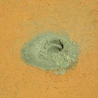
Another successful drill hole although it cracked 'Groken', seemingly along a horizontal vein.

|
Posted by: djellison Oct 17 2020, 11:46 PM
After a ~18 month hiatus - the Navcam quicklook mosaics are flowing to the public website again - these include Az/El grids and are PNGs, not JPGs
https://mars.nasa.gov/msl/multimedia/mosaics
Posted by: PaulH51 Oct 18 2020, 01:05 AM
https://mars.nasa.gov/msl/multimedia/mosaics
Thanks Doug 😊
Posted by: Phil Stooke Oct 22 2020, 10:42 PM
Near the end of our time at Groken. We will be moving very soon.
Phil
Posted by: fredk Oct 26 2020, 04:09 PM
And we're off, after no substantial moves for 94 sols:
https://mars.nasa.gov/msl-raw-images/proj/msl/redops/ods/surface/sol/02923/opgs/edr/fcam/FLB_656987270EDR_F0822638FHAZ00302M_.JPG
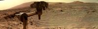
Posted by: Sean Oct 26 2020, 07:43 PM
Full res selfie from Sol 02922
https://flic.kr/p/2jZxaKR
Lots of manual cleanup on this... in addition I replaced the sky and patched gaps in the coverage to complete the comp.
Posted by: neo56 Oct 26 2020, 09:41 PM
And here is my take on this nice selfie with 3 drilling sites gathered on a single selfie :-)
This selfie was taken with Curiosity's head in 2 different positions, shown in this animation:

|
https://flic.kr/p/2jZz8Rr
https://flic.kr/p/2jZz8UH
Posted by: fredk Oct 26 2020, 11:16 PM
Beautiful mosaics, and so quick too.
I don't recall seeing motion blur in these turret images before:
https://mars.nasa.gov/msl-raw-images/proj/msl/redops/ods/surface/sol/02922/opgs/edr/ncam/NRB_656893938EDR_F0822188NCAM00141M_.JPG
I would've thought the shutter speeds were quite short during midday.
Posted by: mcaplinger Oct 27 2020, 12:28 AM
"The nominal exposure time for a noontime image on Mars is approximately .25 seconds."
https://pds.jpl.nasa.gov/ds-view/pds/viewInstrumentProfile.jsp?INSTRUMENT_ID=NAVCAM&INSTRUMENT_HOST_ID=MER1 but the MSL cameras are the same.
Mastcam exposures would be much shorter, yes.
Posted by: Phil Stooke Oct 27 2020, 12:43 AM
To set the stage for the drive which just happened, this is Jan's most recent panorama (after the bump to Groken) in circular form. We just drove to the prominent outcrop to the south in this view (north is at the top).
Phil

|
Posted by: fredk Oct 27 2020, 12:48 AM
https://pds.jpl.nasa.gov/ds-view/pds/viewInstrumentProfile.jsp?INSTRUMENT_ID=NAVCAM&INSTRUMENT_HOST_ID=MER1 but the MSL cameras are the same.
Thanks - with f/12 optics and limited bandpass I guess that sounds reasonable. It's always cool to see some evidence of dynamics in these pics.
Posted by: djellison Oct 27 2020, 01:57 AM
Exactly why we do these occasional NCAM movies of the MAHLI selfie process. They're fun - you maybe get motion blur - you get a GIF that explains how we take selfies - and honestly....it's just damn cool
It was intentionally planned as an in-parallel dust devil movie like activity rather than one ncam image per MAHLI frame in the hope we would see motion
The previous one ( Sol 2687 ) is in the PDS
https://photojournal.jpl.nasa.gov/catalog/PIA23624
https://photojournal.jpl.nasa.gov/catalog/PIA23625
https://pds-imaging.jpl.nasa.gov/data/msl/MSLNAV_0XXX/DATA/SOL02687/
Exposure times were ( example https://pds-imaging.jpl.nasa.gov/data/msl/MSLNAV_0XXX/DATA/SOL02687/NRB_636029467EDR_T0790000NCAM00141M1.LBL )
EXPOSURE_DURATION = 291.84 <ms>
The thing that's easy to forget with the MSL and MER Engineering Cameras - their filter is quite narrow and quite red - it's 600-800nm ( see page 5 https://www-robotics.jpl.nasa.gov/publications/Mark_Maimone/fulltext.pdf )
The weirdest thing I've done with imagery from any rover was to take the mean of all the frames of that 2687 selfie movie.......

|
Posted by: Phil Stooke Oct 27 2020, 03:36 AM
Tumbleweed!
Phil
Posted by: John Moore Oct 27 2020, 04:13 AM
Think, it's a Bob Ross painting.
John
Posted by: PaulH51 Oct 27 2020, 06:06 AM
Rover vaporized by the locals after they lost patience due to the never ending laser strikes.
Posted by: jvandriel Oct 27 2020, 03:24 PM
The Navcam L view on Sol 2923.
Jan van Driel

|
Posted by: Phil Stooke Oct 27 2020, 05:56 PM
Thanks, Jan. Here is a version in circular form showing the new position adjacent to the outcrop. I'm impressed how accurate the drive was.
Phil

|
Posted by: neo56 Oct 27 2020, 06:20 PM
Quick and dirty animation of the first and latest selfies taken on sol 84 and 2922. Nearly 8 years apart!
I remember someone said the RTG stays cleaner because it's hotter: convection movement removing dust?

|
Posted by: centsworth_II Oct 27 2020, 07:42 PM
Besides the dust, the other big change is in the Rover wheels.
Posted by: jvandriel Oct 28 2020, 10:45 AM
The MASTcam L view on Sol 2923.
Jan van Driel

|
Posted by: jvandriel Oct 28 2020, 08:32 PM
The Navcam L view on Sol 2924.
Jan van Driel

|
Posted by: Phil Stooke Oct 29 2020, 07:43 PM
Thanks, Jan. Here is a circular version which gets very distorted by being so close to a rock face.
Phil

|
Posted by: neo56 Oct 29 2020, 09:39 PM
https://www.flickr.com/photos/thomasappere/50545575107/sizes/o/
Posted by: jvandriel Oct 30 2020, 03:37 PM
The Navcam L view on Sol 2926.
Jan van Driel

|
Powered by Invision Power Board (http://www.invisionboard.com)
© Invision Power Services (http://www.invisionpower.com)