Printable Version of Topic
Click here to view this topic in its original format
Unmanned Spaceflight.com _ MSL _ Traversing the Clay-Bearing Unit Along the Base of VRR
Posted by: PaulH51 Jan 22 2019, 12:11 PM
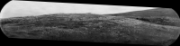
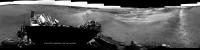
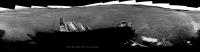
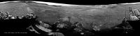
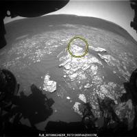
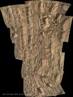
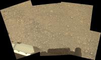
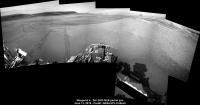
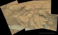
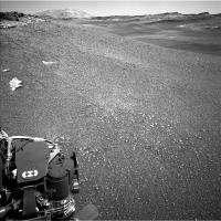
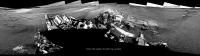
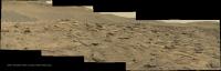
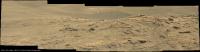
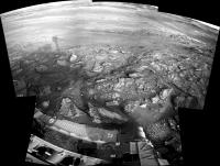
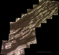
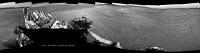
~50 minute drive on sol 2297, unsure of the direction, but this partial pan from the 6 available L-NavCam frames may help narrow down the location. Roughly assembled in MS ICE, no additional image processing.
|
edit, typo fixed
Posted by: PaulH51 Jan 23 2019, 11:52 AM
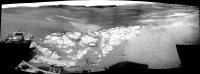
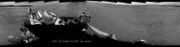
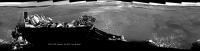
A long-distance RMI mosaic from sol 2298, roughly stitched together in MS ICE, no additional processing.
|
Posted by: fredk Jan 23 2019, 03:35 PM
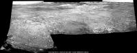
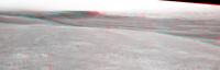
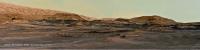
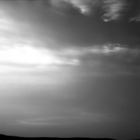
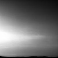
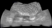
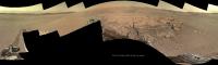
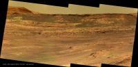
We're starting to get a stunning view of the south edge of VRR:
http://mars.jpl.nasa.gov/msl-raw-images/proj/msl/redops/ods/surface/sol/02298/opgs/edr/ncam/NLA_601513401EDR_F0731692NCAM00257M_.JPG
Posted by: wildespace Jan 23 2019, 04:43 PM
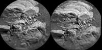
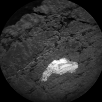
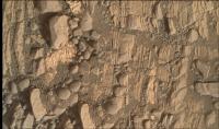
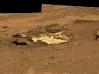
Sol 2297 ChemCam. Some little rocks got displaced by the laser? Or the result of drilling?
|
*flick GIF)
|
Posted by: Phil Stooke Jan 23 2019, 07:21 PM
Just the laser. As if you can say 'just the laser' about firing a laser on Mars.
Phil
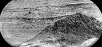
Posted by: atomoid Jan 23 2019, 11:06 PM
Great works, keep them coming!
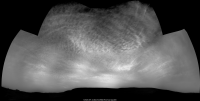
as fredk noted above, the south end of VRR is coming into view and it seems to be smoothing out a bit, made me think of the view into Endeavor just before going down into Perseverance..
fascinating looking at all the http://www.midnightplanets.com/web/MSL/image/02298/CR0_601500017PRC_F0731482CCAM05298L1.htmlthese sols..
here's an attempted stereo of sol2298 stitch anaglyph and crosseye
|

|
Posted by: jccwrt Jan 24 2019, 05:11 AM
My takes on the recent RMI mosaics:
Sol 2295
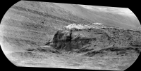
|
Sol 2298
|
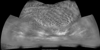
Posted by: xflare Jan 24 2019, 08:23 AM
Reminiscent of parts of the interior of Endurance and Victoria Craters at Meridiani
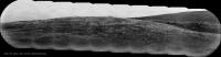
Posted by: fredk Jan 24 2019, 03:52 PM
Long-baseline stereo views from sols 2298 and 2299. Anaglyph:

|
And cross-eyed:
|
|
Posted by: Sean Jan 25 2019, 03:57 PM
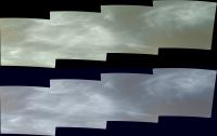
Sol 2299 Mastcam Right
DeBayered, repaired, extended sky...
https://flic.kr/p/2d2b1xx
Full width...
https://flic.kr/p/SgRxAL
Posted by: jccwrt Jan 25 2019, 07:47 PM
Hmm, I'd like to see some RMI mosaics of those erosional scarps. Looks like there's a couple good erosional exposures of the contacts there, might be helpful for doing some remote stratigraphy.
Posted by: Sean Jan 25 2019, 11:05 PM
Sol 2299 mastcam Right with CG Curiosity for context, scaled using HiRISE reference...
Zoom...
https://flic.kr/p/2d2tF3p
Wide...
https://flic.kr/p/2d2tFSa
Posted by: Sean Jan 26 2019, 01:24 AM
Here is a link to the https://we.tl/t-zZPNWl9SYy MR files
Available for 1 week from today.
Posted by: charborob Jan 26 2019, 09:20 PM
Sol 2299 Rmastcam panorama:
https://flic.kr/p/23PCTcD
Thanks Sean, again, for debayering these images.
Sol 2299 Lmastcam post-drive view:
https://flic.kr/p/23PCJYp
Sol 2300 Lmastcam post-drive:
https://flic.kr/p/2dk2zGN
Posted by: charborob Jan 26 2019, 09:41 PM
Sol 2301 RMI mosaic:
|
Posted by: PaulH51 Jan 26 2019, 11:13 PM
Some lovely images, thanks all
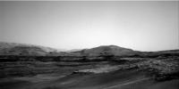
2300 L-MastCam Weekend Workspace (MS ICE)

|
Posted by: jccwrt Jan 27 2019, 12:03 AM
My take on the VRR RMI mosaic:
|
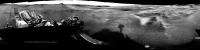
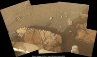
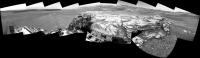
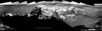
Posted by: PaulH51 Jan 28 2019, 02:42 AM
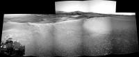
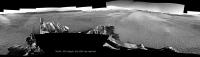
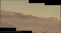
Soaking up the view after the drive on sol 2302 
|
partial pan
|
Posted by: jvandriel Jan 28 2019, 08:56 PM
Back from Hospital and surgery and now stitching again.
The Navcam L view on Sol 2302.
Jan van Driel

|
Posted by: PaulH51 Jan 28 2019, 11:25 PM

Good to have you back...
Posted by: PaulH51 Jan 29 2019, 02:04 PM
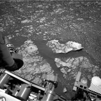
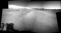
2302ML (drive direction?) Looking fairly wheel friendly, but maybe not too many contact science opportunities
|
|
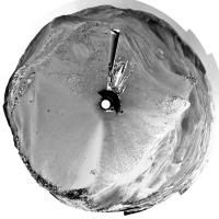
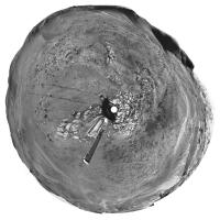
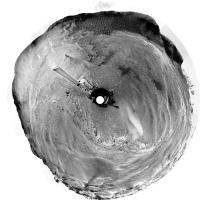
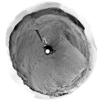
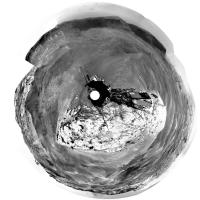
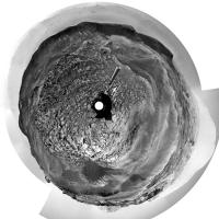
Posted by: Phil Stooke Jan 30 2019, 07:17 PM
I'm glad you are back, Jan, and I hope you are doing well.
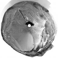
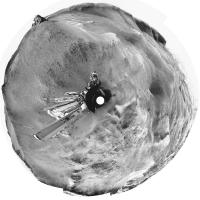
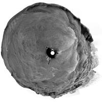
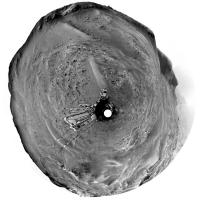
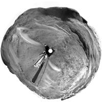
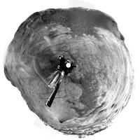
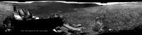
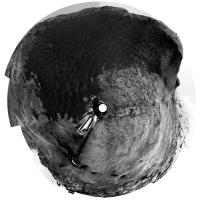
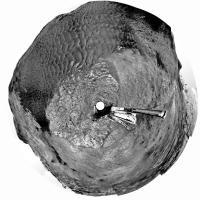
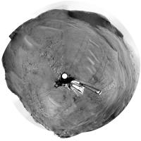
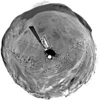
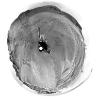
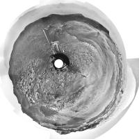
Here is your sol 2302 panorama in circular form.
Paul - I think that drive direction mosaic was taken assuming the rover would be at the top of the ridge looking out across the wider landscape. Next time, maybe!
Phil
|
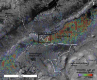
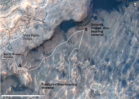
Posted by: elakdawalla Jan 30 2019, 07:39 PM
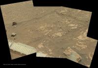
Ashwin confirmed to me today that they are "definitely on the clays," so I've created a new thread here.
A newly posted http://www.hou.usra.edu/meetings/lpsc2019/pdf/2826.pdf. They plan to do a Z-shaped traverse -- first drive northeast along the base of the ridge to look at stratigraphy and reach the lowest-elevation point where there is a strong clay signal from orbit. Then they will turn southwest and climb across the clay-bearing unit vertically, until they get to the Greenheugh Pediment (the plateau made by the inverted channel coming off Mount Sharp). Then they'll turn southeast, poking along the base of the pediment and looking into alcoves.
Here are a couple of maps from Fox et al.
|
|
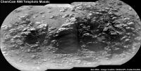
Posted by: jccwrt Jan 31 2019, 04:15 AM
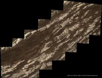
Sol 2304 RMI mosaic of Greenheugh Pediment:
|
Posted by: jvandriel Jan 31 2019, 11:06 AM
The Navcam L view on Sol 2304.
Jan van Driel
|
|
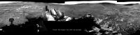
Posted by: charborob Jan 31 2019, 12:16 PM
Sol 2304 Lmastcam post-drive:
https://flic.kr/p/QKqp4x
Posted by: elakdawalla Jan 31 2019, 07:44 PM
According to Ashwin, sol 2302 was the day they drove in to the clay-bearing unit.
Posted by: Sean Jan 31 2019, 10:55 PM
Sol 2302 panorama from mastcam left & right, debayered & blended with extended sky...
211 Megapixel
https://flic.kr/p/2dq4gcC
Curi context...
https://flic.kr/p/So2QPY
Detail...
https://flic.kr/p/2ewanTe
https://we.tl/t-h2swHKgImd
https://we.tl/t-VoIpDaOxLM
Links are active for 7 days
Posted by: PaulH51 Jan 31 2019, 11:03 PM
Those are lovely Sean
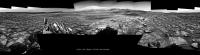
Partial NavCam pan after the short drive on sol 2306, roughly stitched in MS ICE
|
Posted by: jvandriel Feb 1 2019, 06:37 PM
The Navcam L view on Sol 2306.
Jan van Driel
|
Posted by: atomoid Feb 2 2019, 12:45 AM
Nice stitches and renderings <http://www.unmannedspaceflight.com/index.php?showtopic=8460&view=findpost&p=243652 and http://www.unmannedspaceflight.com/index.php?showtopic=8460&view=findpost&p=243661>. (if youre like me and want to download them, and find that Flickr's "flic.kr" abbreviated URL scheme resolves to an overlay that doesn't have download menu widgets or even allow right-click download, you can simply append "/sizes" to the resultant URL to force to the 'all sizes' download page).
the scale of Curi in the distance serves to remind me how my eye tends to overestimate the scale of landscape features.
Here are some quick stereo views from select http://www.midnightplanets.com/web/MSL/image/02306/NLA_602216832EDR_F0732502NCAM00267M_.html navcam sets
|
|

|

|
Posted by: Phil Stooke Feb 4 2019, 07:35 PM
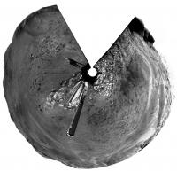
Here are Jan's last two panoramas in circular form, showing progress relative to the small ridge. We just drove down the other side of the ridge and turned left, so I can feel another map coming on.
Phil
Sol 2304:
|
Sol 2306:
|
Posted by: jvandriel Feb 4 2019, 08:32 PM
The Navcam L view on Sol 2309.
Jan van Driel
|
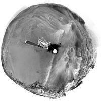
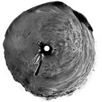
Posted by: Phil Stooke Feb 6 2019, 09:13 PM
Jan's 2309 panorama in circular form. We are well beyond this now and I need to get onto the map.
Phil
|
Posted by: atomoid Feb 6 2019, 09:27 PM
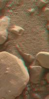
MAHLIs of the rock with the LIBS sweep http://www.midnightplanets.com/web/MSL/image/02309/2309MH0001930000803914R00_DXXX.html share an overlap that works for stereo (crosseye/anaglyph):
|
|
Posted by: PaulH51 Feb 7 2019, 05:09 AM
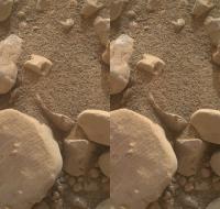
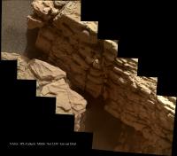
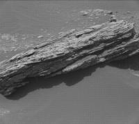
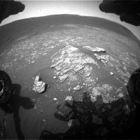
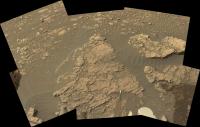
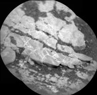
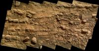
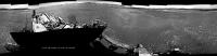
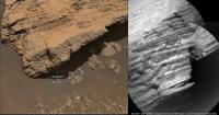
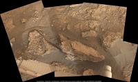
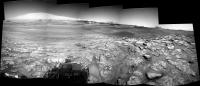
A rather nice looking outcrop, images from sol 2311 by the R-MastCam before the long drive, should look much nicer in colour when debayered, but even in its Bayer format it looked good enough to share here
|
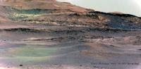
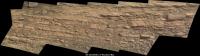
Posted by: charborob Feb 7 2019, 11:40 AM
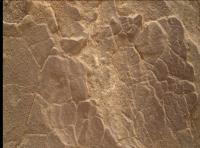
Here is the debayered image:

|
And here is the sol 2311 Lmastcam post-drive panorama:
https://flic.kr/p/2ey29f7
Posted by: jvandriel Feb 8 2019, 02:46 PM
The Navcam L view on Sol 2311.
Jan van Driel
|
|
Posted by: jvandriel Feb 8 2019, 08:36 PM
and the view on Sol 2313.
Jan van Driel
|
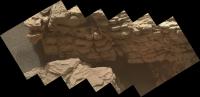
Posted by: PaulH51 Feb 10 2019, 01:04 AM
Sol 2313 L-MastCam post-drive panorama, easy driving conditions ahead
|
|
Posted by: PaulH51 Feb 11 2019, 02:18 AM
Drive on sol 2316. Looks like an opportunity for some contact science, or maybe a another touch and go
Roughly assembled in MAS ICE using some of the post drive L-NavCams
|
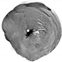
Posted by: Phil Stooke Feb 11 2019, 03:20 AM
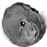
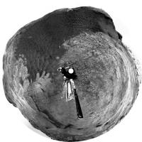
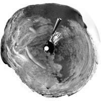
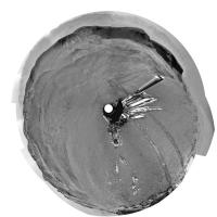
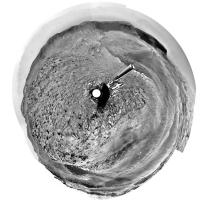
Thanks! Paul's partial panorama let me find the location for the map, and here is Jan's panorama from sol 2313 in circular form, showing tracks.
Phil
|
Posted by: jvandriel Feb 11 2019, 09:30 PM
The Navcam L view on Sol 2316.
Jan van Driel
|
|
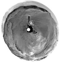
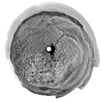
Posted by: Phil Stooke Feb 14 2019, 06:33 AM
Very nice, Jan. Here is a circular projection of your panorama.
Phil
|
Posted by: jccwrt Feb 15 2019, 06:03 AM
Enhanced movie of a dust devil drifting by on Sol 2310. Covers about 2 minutes, with 12 seconds between each frame.

|
Posted by: PaulH51 Feb 18 2019, 10:14 PM
I seem to recall an announcement that MRO would be assigned solely to InSight for the initial part of its mission, with other orbiters providing the DSN relay for Curiosity. The most recent image in the MSL JPL image server was acquired on sol 2320, 4 sols ago. Has anyone heard of any communication issues? Also are there any status pages for the Mars orbiters that would provide this sort of detail TIA
Posted by: PaulH51 Feb 20 2019, 06:54 AM
Sol 2320: Left NavCam post drive partial pan, roughly assembled in MS-ICE. Poorly stitched, but hopefully it will assist in narrowing down the new location

|
Posted by: jvandriel Feb 20 2019, 08:27 PM
The Navcam L view on Sol 2320.
Jan van Driel
|
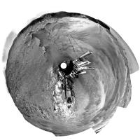
Posted by: Phil Stooke Feb 20 2019, 10:34 PM
Thanks, Jan. I made a circular version of this panorama to show where we are, after taking the liberty of patching the image to show the tracks behind us where they were partly hidden by the rear antenna.
Phil
|
Posted by: PaulH51 Feb 22 2019, 11:40 PM
The lack of images after Curiosity's drive on sol 2320 is explained in this release by NASA/JPL which documents a computer reset.
https://www.nasa.gov/feature/jpl/after-a-reset-curiosity-is-operating-normally
Posted by: PaulH51 Feb 28 2019, 11:20 AM
Science activities resume in Gale crater, with ten images from sol 2333 returned by Curiosity, here is a rather nice target imaged with ChemCam's RMI
|
|
Edit: Added the mast cam context image, scaled using AlgorimancerPG, apologies for the de-bayer colour
Catch the rest of the images http://www.midnightplanets.com/web/MSL/sol/02333.html
Posted by: PaulH51 Mar 1 2019, 11:05 AM
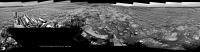
L-MastCam sol 2320 Workspace, assembled in MS ICE (unprocessed)
|
Posted by: PaulH51 Mar 2 2019, 10:23 AM
L-MastCam mosaic: Sol 2320 NNE - ENE and ~200 meters from a possible drill site. Stitched in MS ICE, no additional processing.
|
|
Posted by: PaulH51 Mar 6 2019, 01:05 AM
2338 NLA after a drive of ~24.4m ESE (http://www.midnightplanets.com/web/MSL/sol/02338.html) roughly assembled in MS ICE no additional processing, may help identify the location
|
|
Posted by: jvandriel Mar 6 2019, 02:23 PM
The Navcam L panoramic view on Sol 2338.
Jan van Driel
|
|
Posted by: Phil Stooke Mar 6 2019, 08:03 PM
Jan's nice new panorama in circular format.
Phil
|
Posted by: PaulH51 Mar 11 2019, 09:16 AM
Looking like Curi is MIA again, today is sol 2344

Posted by: jvandriel Mar 11 2019, 08:07 PM
The Mastcam L view on Sol 2312.
126 images Debayered and stitched.
Thanks Sean, Debayering took me now 2-3 hours instead of 2-3 days.
Jan van Driel
|
|
Posted by: djellison Mar 12 2019, 10:45 PM
Update : https://www.jpl.nasa.gov/news/news.php?feature=7339
The mission team decided to switch from the Side-A computer back to the rover's Side-B computer, which it operated on for most of the mission until November of 2018. Side-B recently experienced its own memory issue; the team has since further diagnosed the matter, reformatting the Side-B computer to isolate areas of "bad" memory. As of today, Curiosity is out of safe mode, and the team is configuring the rover for new science operations in the clay unit. Curiosity is expected to return to science operations as early as Wednesday.
Posted by: tanjent Mar 13 2019, 02:59 AM
This sounds at least superficially similar to the events that caused Opportunity to shut down her flash memory. Does Curiosity have the same option if these problems continue?
Posted by: jvandriel Mar 14 2019, 09:19 PM
The MAHLI view on Sol 2339.
Jan van Driel
|
Posted by: PaulH51 Mar 15 2019, 05:44 AM
http://www.midnightplanets.com/web/MSL/sol/02347.html is indicating a drive on sol 2347 to Site 75/0000. However the front HazCams appear to indicate the rover remained at the same location.
Edit: Just realised this sequence was likely commanded as they switched to the other computer, so not an aborted drive.
Posted by: PaulH51 Mar 15 2019, 06:25 AM
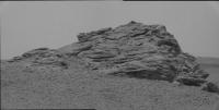
My version of 'Fife' using the focus merged versions that were downlinked later:
Stitched and rotated in MS ICE, otherwise unprocessed.
|
Posted by: PaulH51 Mar 16 2019, 09:08 AM
Hard to be sure, but there appears (to my ageing eyes) that there could be some cross bedding in https://mars.jpl.nasa.gov/msl-raw-images/msss/02339/mcam/2339MR0124290031001193C00_DXXX.jpg bayer encoded R-MastCam from sol 2339
|
Posted by: PaulH51 Mar 17 2019, 12:44 PM
Looks like the MAHLI imaged a DRT site on sol https://mars.jpl.nasa.gov/msl-raw-images/msss/02349/mhli/2349MH0001220010804400C00_DXXX.jpg, I think it may be the site brushed back on 2339 before the reset. The MAHLI shows was looks like surface scratches from using the DRT(center of the brushed area). If these are scratches, it could bode well for easier drilling / sampling in this area.
|
Posted by: jccwrt Mar 17 2019, 02:49 PM
Cross-bedding is a possibility there. I remember seeing some crossbeds of similar dip in the rocks coming off VRR so I would not be surprised if they are present in much of the clay unit.
Posted by: jvandriel Mar 17 2019, 03:26 PM
The Mastcam L view on Sol 2339.
Jan van Driel
|
Posted by: jvandriel Mar 17 2019, 03:28 PM
and the Mastcam R view on Sol 2339.
Jan van Driel
|
|
Posted by: jvandriel Mar 18 2019, 02:25 PM
Nice view on Sol 2347.
Jan van Driel
|
|
Posted by: jvandriel Mar 20 2019, 03:10 PM
The Navcam L view on Sol 2352.
Jan van Driel
|
Posted by: jccwrt Mar 20 2019, 03:50 PM
Looking at a couple of posters last night, looks like the Clay-Bearing Unit might be named as "Glen Torridon". Not sure if it's still considered a subunit of the Murray formation, or if it's being split out into a new formation.
Posted by: PaulH51 Mar 21 2019, 12:43 PM
There seems to be a little activity in a planned DD search using the NavCam early on sol 2353, the brief activity can just be observed in the unprocessed frames, just to the left of center, maybe a gust wind raised some surface dust. The proper processing could reveal more detail
There are also several darker frames in the very large set of bayer encoded L-MastCam sequence on sol 2350, which was the sol they imaged the Deimos transit. Clearly they can not be the sky darkening because of the eclipse so maybe they captured a vortex or vortex's passing close to the rover? The entire sequence has yet to the downlinked, but there are over 100 already down. Sadly I can't create a GIF with so many images, but here are 10 frames assembled into a simple GIF from the beginning of the sequence, where you can observe one of the events. Note I set the blink rate at a quarter of a second

|
Posted by: PaulH51 Mar 21 2019, 01:12 PM
Drive direction (unprocessed) L-MastCam, sol 2352: Taking us further North into the clay deposits of Glen Torridon

|
Posted by: Phil Stooke Mar 21 2019, 02:34 PM
Here are two circular projections of Jan's latest panoramas. I will use them to update the map when I can get to it, maybe not for a few days.
Phil
Sol 2347:
|
Sol 2352:
|
Posted by: fredk Mar 21 2019, 02:58 PM
The darker frames' filenames end in "...C00_DXXX", versus "...K00_DXXX" for the rest, so there must be something different about the exposure or stretching on those.
Posted by: PaulH51 Mar 21 2019, 11:41 PM
Many thanks for the feedback, I'd not spotted the file name changes. Disappointing, was hoping it was a DD
Posted by: PaulH51 Mar 22 2019, 01:18 AM
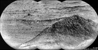
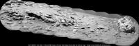
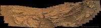
Long distance RMI of an outcrop located North(?) of the rover on sol 2354
|
Posted by: jvandriel Mar 22 2019, 02:20 PM
The Navcam L view on Sol 2350.
Jan van Driel
|
|
Posted by: mcaplinger Mar 22 2019, 05:34 PM
C means losslessly-compressed 8-bit raster image and K means losslessly-compressed 8-bit raster video, so by itself that doesn't say anything about the exposure (see https://pds-imaging.jpl.nasa.gov/data/msl/MSLMST_0002/DOCUMENT/MSL_MMM_EDR_RDR_DPSIS.PDF ) but if you don't have the metadata you have no way to know what the exposure times were.
Posted by: atomoid Mar 23 2019, 12:54 AM
|
|
and yep its almost exactly North from here, part of the underexposed outcrop in the upper left of the navcam from http://www.midnightplanets.com/web/MSL/image/02352/NRB_606304724EDR_F0750264NCAM00292M_.html much better views in the bayered mastcam http://www.midnightplanets.com/web/MSL/image/02353/2353ML0124840230207225C00_DXXX.html or most recent color mastcam from http://www.midnightplanets.com/web/MSL/image/02320/2320ML0124000000406441E01_DXXX.html
Posted by: jvandriel Mar 23 2019, 04:19 PM
The Navcam L view on Sol 2354.
Jan van Driel
|
Posted by: jvandriel Mar 24 2019, 03:30 PM
Playing with a few images on a Sunday afternoon.
Sol 2353 Mastcam L view.
Jan van Driel
|
Posted by: jvandriel Mar 25 2019, 07:01 PM
and the complete Mastcam L view on Sol 2353.
Jan van Driel

|
Posted by: atomoid Mar 25 2019, 08:56 PM
early easter egg hunting? finding scattered nice and clear (quartz?) grains and apparent concretions in the MAHLIs from http://www.midnightplanets.com/web/MSL/sol/02356.html and http://www.midnightplanets.com/web/MSL/image/02357/2357MH0001630000804600R00_DXXX.html
|
Posted by: PaulH51 Mar 26 2019, 03:12 AM
Looks like this is the L-MastCam drive direction section of what will be a wider mosaic from sol 2357 (MS-ICE / slightly darkened)
The https://mars.jpl.nasa.gov/msl/mission/mars-rover-curiosity-mission-updates/?mu=sols-2359-2360-hopping-from-outcrop-to-outcrop talked about speculation that the lone float rock (left of center) could be a meteorite or possibly or a remnant of a higher, eroded unit, but the next drive will take the rover to the subtle ridges (visible just to the left of the float rock) and image the float rock from there as well as the small butte in the middle of this mosaic.
|
|
Posted by: PaulH51 Mar 26 2019, 03:47 AM
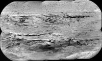
Long distance RMI mosaic of another exposure of the Vera Rubin Ridge, this time looking Northwest of the rover during sol 2357.
I used the 4 enhanced data product frames for this mosaic, a fifth image was not available in that format when I assembled this in MS-ICE, no additional processing except for adding the annotations.
|
Posted by: PaulH51 Mar 26 2019, 10:06 AM
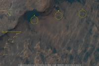
Posted this here to keep the signal to noise ratio down on the map thread. I've annotated my guesstimate of where the rover is after its drive on sol 2357 onto a crop of the JPL location map for sol 2354, but that's not the main reason for this post. For fun I'm looking at potential drill / sample sites in the clay unit...
I've circled three possible sites: A, B and C: My favourite at the moment is A, with C running a close second, C looks to have more potential, but it's a little off the published path.
|
Posted by: jvandriel Mar 26 2019, 01:58 PM
The Navcam L view on Sol 2357.
Jan van Driel
|
|
Posted by: fredk Mar 26 2019, 06:09 PM
We had a transient darkening of the sky just after sunset on 2358. All I can think of is a Phobos transit, with centreline just to our north. Very cool. Here's an animation:
|
Posted by: djellison Mar 26 2019, 06:15 PM
Well spotted
Posted by: Phil Stooke Mar 26 2019, 07:46 PM
And not long ago we had that at InSight as well.
Phil
Posted by: serpens Mar 26 2019, 09:51 PM
From Michelle Minitti's mission update 23 March "Finally, Navcam will attempt to capture Phobos, one of Mars's moons, transiting across the Sun in the Martian sky".
It seems their attempt was successful
Posted by: djellison Mar 27 2019, 04:09 AM
What my version of it using the raw JPGs looks like. And a whole thread of discussion about it right here : https://twitter.com/doug_ellison/status/1110748122831978496
Kudos to FredK for figuring it out before I'd even seen the images

|
Posted by: fredk Mar 27 2019, 04:05 PM
Nice. Here's yet another version, subtracting the smoothed average of all the frames from each smoothed frame, and adding a multiple of that to each frame:

|
This is about 8x faster than real time.
http://www.greuti.ch/msl/clock_and_filenames.htm says this sequence spanned sunset, but I'm not sure how accurate that clock is. The optimal time to see this would be right after sunset - much later and the lower atmosphere wouldn't be illuminated directly by the sun so wouldn't directly experience the shadow.
Posted by: djellison Mar 27 2019, 05:17 PM
That site seems to be accurate to within about 15seconds of what I'm seeing on the ground.
First frame took longer to execute as the mast had to slew from stowed up to the pointing, and then iterate the auto-exposure a couple of times.
Second frame was at 18:40:14, and the last at 18:43:13 - time between frames was around 7.5 seconds ( we didn't command a pause - that's just as quick as you can take images with the NavCams with some options turned off to speed things up)
Sunset was 18:40:26, but 'local' sunset behind the back of the Vera Rubin Ridge was probably a little earlier than that.
Posted by: Phil Stooke Mar 27 2019, 08:14 PM
Jan's panorama from sol 2357 in circular form. I can't emphasize enough how useful it is to have these panoramas posted like this to help me find locations for my maps. Thanks, Jan!
Phil

|
Posted by: jvandriel Mar 27 2019, 08:52 PM
Special for Phil,
the Navcam L view on Sol 2359.
Jan van Driel
|
|
Posted by: elakdawalla Mar 27 2019, 10:01 PM
I just asked Ashwin about this and got the following clarification: Glen Torridon refers to the geomorphological valley south of the Vera Rubin Ridge. It is more or less coincident with the CRISM clay signature, but not perfectly so. The clay unit doesn't have a name associated with it and won't until they've mapped its extent and figured out how it fits in with the Murray stratigraphy.
Posted by: jccwrt Mar 28 2019, 02:15 AM
Thanks! Good to know.
NavCam caught a wind gust on Sol 2357, here is a processed video:

|
Also I tried my hand at processing and colorizing the eclipse sunset using a template sunset from Gusev Crater (thanks Spirit!) and some NavCam imagery taken the previous sol.

|
Posted by: jvandriel Mar 29 2019, 07:38 PM
The Navcam L view on Sol 2361.
Jan van Driel

|
Posted by: Phil Stooke Mar 30 2019, 04:43 AM
Thanks, Jan - here is a circular version which i used to get the new location for the map.
Phil

|
Posted by: jvandriel Mar 30 2019, 02:49 PM
Added 7 images to complete the 360 Navcam L view on Sol 2361.
Jan van Driel

|
Posted by: PaulH51 Apr 1 2019, 03:22 AM
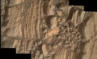
One of the ChemCam targets on sol 2362 in this animated RMI before and after GIF, I added margins to roughly align the target on the frames

|
Posted by: tanjent Apr 1 2019, 04:50 AM
If that is a ceramic, it is very nicely glazed. A little bird or a calligraphic inscription would suit the occasion.
Seriously though, I guess gravity alone accounts for the way the dark chips all migrated to the lower left of the target area?
Posted by: Actionman Apr 1 2019, 06:41 PM
Excuse me but I'm not seeing where as the laser help in the melting of this here glass.
Posted by: Sean Apr 1 2019, 07:25 PM
https://twitter.com/_TheSeaning/status/1112793238790983688
Posted by: PaulH51 Apr 2 2019, 11:36 AM
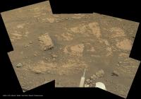
A very short drive, straight ahead to a nice looking outcrop during sol 2365:
|
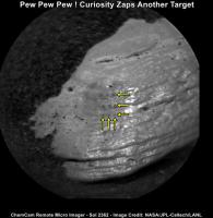
Posted by: PaulH51 Apr 2 2019, 11:48 AM
I have annotated the three rows and three columns of the small pits created by the ChemCam laser. The before and after images are included in the animated GIF
|
Posted by: jvandriel Apr 2 2019, 01:38 PM
The Navcam L view on Sol 2364.
Jan van Driel
|
|
Posted by: Phil Stooke Apr 2 2019, 09:17 PM
Here are circular views of Jan's recent panoramas to help show our progress through the clay-rich Glen Torridon.
sol 2359:
|
sol 2361:
|
sol 2364:
|
Phil
Posted by: atomoid Apr 2 2019, 10:47 PM
I like that question, would the tiny spot of glassy weathering polish re-qualify as a 'glass' after treated to an RMS hit?
As much fun as it would be to say Curiosity is busy giving Martian rocks a stoneware reduction glaze fired to cone ten, I couldn't find much on RMS target point temp other than its 10 MW/mm (http://www.msl-chemcam.com/index.php?menu=inc&page_consult=textes&rubrique=86&sousrubrique=&soussousrubrique=&art=259&titre_url=ChemCam&step=2#.XKPiW7h7lEY, so doesn't seem much chance to anything that can be described as a melt as ablates straight to plasma, though seems there ought to remain a trace residue that condenses back onto the rock that may perhaps be a glass, more https://msl-scicorner.jpl.nasa.gov/Instruments/ChemCam/ of interesting stuff to read up on..
Posted by: Actionman Apr 3 2019, 12:27 AM
Using the term "glass" very loosely, it's sure looks shiny! and the laser virtually destroyed the shininess in the area,, I'm going to say with it's residual heat. So it's not a pottery like glaze.
Posted by: jvandriel Apr 3 2019, 08:14 AM
The Navcam L view on Sol 2365.
Jan van Driel
|
|
Posted by: PaulH51 Apr 3 2019, 09:12 AM
Sol 2365 L-MastCam: Arm workspace, assembled in MS ICE, else unprocessed.
|
Posted by: PaulH51 Apr 3 2019, 01:16 PM
I'm guessing that this could be "Lumphanan", which according the the https://mars.jpl.nasa.gov/msl/mission/mars-rover-curiosity-mission-updates/?mu=sols-2365-2366-edging-closer-and-closer-to-a-new-drill-target may be a fragment of an iron meteorite.
Apologies for the terribly de-bayered R-MastCam from sol 2365

|
Posted by: Sean Apr 4 2019, 02:53 PM
Sol 2365 Mastcam Left, 9 frame DeBayered composite, extended sky
https://flic.kr/p/ThkBwY
https://we.tl/t-LJkGqbqBCV is a link to DeBayered files of Mastcams Left & Right, available for 7 days
Posted by: jvandriel Apr 4 2019, 05:23 PM
MASTcam R view on Sol 2365.
Jan van Driel
|
Posted by: jvandriel Apr 4 2019, 05:42 PM
and my take on the Sol 2365 MASTcam L view.
Jan van Driel

|
Posted by: PaulH51 Apr 7 2019, 10:24 PM
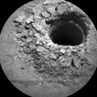
And another sample hole drilled into Mars Sol 2370 at Aberlady
|
Posted by: serpens Apr 8 2019, 08:12 AM
Looks like full depth achieved in just over an hour. It seems that drilling has become something of a routine event. All credit to the engineering team.
Posted by: PaulH51 Apr 8 2019, 11:47 AM
Seconded
Here is a quickly assembled z-stack of 'Aberlady' using a selection of the RMI's from sol 2371, and a red-cyan anaglyph, both assembled in Picolay.
|

|
Posted by: algorithm Apr 9 2019, 02:18 PM
A quick animated gif showing the recent drilling activity.

|
Posted by: PaulH51 Apr 11 2019, 01:39 PM
Sol 2373 CheMin port before and after sample drop? L-MastCam GIF

|
Posted by: charborob Apr 15 2019, 01:09 AM
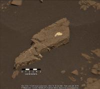
Midnight Planets seems to be stuck on sol 2374.
Anyway, from MSL's raw images pages, ChemCam caught this view of what looks like a meteorite on sol 2376:

|
Posted by: PaulH51 Apr 15 2019, 03:11 PM
Hand Lens from sol 2377 which I presume is the remaining powdered rock sample from 'Aberlady' that was dumped after they decided not to place any of this sample inside SAM.

|
Posted by: jvandriel Apr 15 2019, 08:42 PM
Mastcam R view on Sol 2376
Jan van Driel

|
Posted by: phase4 Apr 16 2019, 02:53 PM
Here is a 360 panorama timelapse of Curiositys mission up to Sol 2374.
Raw and unpolished, hope you enjoy!
https://vimeo.com/330789196 and https://www.youtube.com/watch?v=CP-TE1eyibQ
Youtube allows zooming (on desktop) and works great on PS4 with VR headset!
Posted by: PaulH51 Apr 16 2019, 10:55 PM
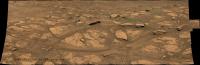
Sol 2379 - RMI Telephoto mosaic of the Sulfate Unit to the Southeast of the Rover roughly assembled in MS ICE, no additional processing except for the annotation.

|
Posted by: atomoid Apr 16 2019, 11:01 PM
Great thanks for posting this, like the ones you did for MER, its an absolute blast!
having no VR gear myself, in YouTube you hit 'f' to go to fullscreen and mousewheel up to zoom all the way out for the best view, then, since the orientation remains static you can just point your viewport at Mt sharp and enjoy the whole traverse over to VRR as it slowly comes better into view, then back up a few years, swing the viewport around 180 for a rear view of the crater rim, enjoy watching the buttes recede all the while seeing how the Tau goes from good to bad to ugly by the 6/17/2018 frame.. im experiencing the mission in a whole new way, really cool!
it would be really interesting to hear what sort of software and processes you labor through in order to create these.
Posted by: PaulH51 Apr 17 2019, 11:18 PM
Sol 2379 MAHLI: simple z-stack of 4 images of the LIBS sites 'Aberlady'.
Both group 1 & 2 white light LEDs were on, the UV LEDs were off.
(assembled in Picolay)

|
Posted by: Steve5304 Apr 18 2019, 12:57 AM
|
|
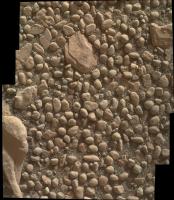
Interesting rock and pebble shapes to the left. Like something on the bottom of a pond. I never get used to seeing those.
Posted by: jvandriel Apr 18 2019, 05:15 PM
The MASTcam L panoramic view on Sol 2375.
Jan van Driel
|
|
Posted by: djellison Apr 18 2019, 09:49 PM
We also took a complete Navcam deck pan to gap fill below the M34 imagery on the following sol at the same time of day
https://mars.jpl.nasa.gov/msl/multimedia/raw/?s=2376&camera=NAV_RIGHT_
https://mars.jpl.nasa.gov/msl/multimedia/raw/?s=2376&camera=NAV_LEFT_
Posted by: jvandriel Apr 20 2019, 12:07 PM
djellison,
I have seen that and tried to stitch the color and black-white images but my software ( Autopano Pro ) does not see it as 1 image and
does not stitch them together.
The same for earlier images.
Here is the navcam L view on Sol 2381.
|
Posted by: serpens Apr 20 2019, 11:05 PM
Reminiscent of Spirit's El Dorado ripple field.
Posted by: PaulH51 Apr 21 2019, 11:08 PM
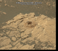
Looking good at Kilmarie!
The amount and shape of the drill cuttings (tailings) could bode well for a sample in the sleeve, fingers crossed they can get this one inside SAM
Nice to see two sample holes in one NavCam frame
Kilmarie is on the right side
|
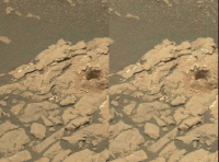
Posted by: PaulH51 Apr 23 2019, 12:39 AM
Simple 'blink GIF' of the R-MastCam frames of 'Kilmarie' on sols 2381 and 2384, roughly aligned by adding margins.
Note the movement of sand and pebbles and the colour differences in the cuttings (tailings)
Those cuttings height appears to be a little smaller than I estimated from the NavCam frames, hope that it's deep enough to have got enough powdered rock into the drill sleeve for analysis.
|
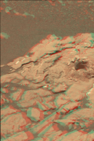
Posted by: atomoid Apr 23 2019, 10:48 PM
thanks, its impressive seeing how much a mess the drilling operations create displacing rocks and sand seemingly far from the intrusion site (check the pebbles in the distance!). it inspired me to create a somewhat sloppy animated gif crossseye/anaglyph using the stereo m100/m34 sets from those SOLs, unfortunately much gets unavoidably cropped out using the Steophotomaker functions
|
|
Posted by: PaulH51 May 1 2019, 03:20 AM
Looking northeast at an upper section of the Vera Rubin Ridge
Sol 2389 R-MastCam, 3-frame mosaic, that I processed, including a patched sky, assembled in MS ICE after coarse de-bayering with GIMP
These frames are part of a set that should make a much larger mosaic, but I'll leave that to those who can properly process these compressed bayer images.
We don't appear to have a mission update for this sol, so not sure if this particular section of ridge was named.
|
Posted by: jvandriel May 1 2019, 07:54 AM
The Mastcam R view on Sol 2389.
97 Images Debayered and stitched.
Jan van Driel
|
|
Posted by: PaulH51 May 4 2019, 08:43 AM
A long distance RMI mosaic of the Sulfate unit.
10 frames from Sol 2396 roughly assembled in MS ICE.
|
Posted by: alan May 4 2019, 08:21 PM
97 Images Debayered and stitched.
Jan van Driel
|
|
Reminds me of the ripple field Spirit visited in the lee of Husband Hill.
Posted by: jvandriel May 5 2019, 03:04 PM
The MASTcam R view on Sol 2390.
Jan van Driel
|
|
Posted by: PaulH51 May 6 2019, 10:40 AM
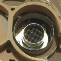
Sol 2397 L-MastCam of an inspection of one of the open inlet ports for SAM. The internal screen appears to be clean, but since the change to Feed Extended Sample Transfer (FEST) and delivering powdered rock directly from the drill sleeve into SAM and CheMin there is no direct screening prior to it being dispensed from the drill sleeve.
I was able to find the screen size (1 mm) for the CheMin inlet port, but I can't find the screen size for SAM, it appears coarser than the screen in CheMin (I guesstimate it to be closer to 2 mm).
Does anyone know of a document that has the actual mesh size or the internal diameter of the inlet funnel TIA
|
Posted by: jvandriel May 6 2019, 01:44 PM
Sol 2390 MASTcam L.
Sunset Animation on Mars.
|
Posted by: serpens May 8 2019, 08:32 AM
A fine and a coarse grid covering the two solid inlets would make sense Paul given that the CHIMRA was designed to produce two samples sieved to less than 1 mm and less than 150 micron for input to the solid inlets. A 1 mm grid for the 150 micron sample and a (2mm) grid for the 1 mm sample would ensure that the samples would pass through the grids.
There is damage evident to the left hand side of the grid in your image. Could this be a function of the tapping delivery workaround for delivering drill samples from the drill tube?
Posted by: PaulH51 May 8 2019, 10:58 AM
There is damage evident to the left hand side of the grid in your image. Could this be a function of the tapping delivery workaround for delivering drill samples from the drill tube?
Thanks
I'm unsure if the minor damage to the mesh is a result of FEST, as far as I can establish, this is the first time that SAM inlet port #1 was imaged in the open position with a MastCam since landing, there are NavCam images acquired during checkout of both SAM ports open in the weeks after landing, but even brightening those images is not conclusive to seeing if that small dent in the mesh was present at that time. SAM inlet port #2 has no obvious mesh (screen) looking the available MastCam images in the open position.
Posted by: charborob May 8 2019, 11:15 AM
Sol 2400 RMI long distance view:
|
Posted by: charborob May 8 2019, 08:44 PM
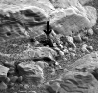
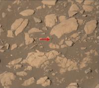
A strange hole in this sol 2399 Rmastcam image (see arrow). Sand displacement due to a laser blast?
|
Posted by: atomoid May 9 2019, 12:49 AM
Thanks by the way for nicely debayering that. Yes it would seem so, looks as if the strafe pattern ended in a clean socket as if a hole, but thats probably shadow tricks.
Here are the sol2399 ChemCam views of it http://www.midnightplanets.com/web/MSL/image/02399/CR0_610468870EDR_F0751398CCAM02397M_.html and http://www.midnightplanets.com/web/MSL/image/02399/CR0_610469957PRC_F0751398CCAM02397L1.html.
it looks like they took a shot at it earlier on sol2394 as well, here are those http://www.midnightplanets.com/web/MSL/image/02394/CR0_610022218PRC_F0751398CCAM03393L1.html and http://www.midnightplanets.com/web/MSL/image/02394/CR0_610023152PRC_F0751398CCAM03393L1.html chemcam views.
Posted by: djellison May 9 2019, 06:59 AM
If you do a row of shots from bottom to top - the little blast from each set of shots in turn scatters some grains back over the previous hole - leaving a little trench. The last hole doesn't get covered over.
Posted by: jccwrt May 10 2019, 03:26 AM
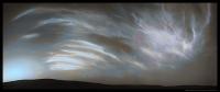
Lots of cirrus-y looking clouds drifting over on the evening of Sol 2400:
|
Posted by: neo56 May 13 2019, 07:55 PM
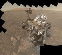
A new selfie is coming, here is a mosaic of the first 41 pictures. Nice to see the two drillholes near the wheels!
|
Posted by: PaulH51 May 13 2019, 10:42 PM
Gotta love them selfies
Meanwhile another lovely set of clouds to the NNE on sol 2405
Edit: I corrected the sequence order and added timestamps, may be a tad slow to load due to file size
|
Posted by: fredk May 14 2019, 03:49 AM
It is a really nice sequence. You can see the clouds getting blurred towards the end (and the hot pixels increase) as presumably the exposures lengthened. (The latest frames chronologically are at the start of your animation, Paul.)
Posted by: PaulH51 May 14 2019, 04:09 AM
Yeah I'm going to be making a new one, I rush the assembly and put them in the wrong order, only realised I'd goof'ed when I saw another version of twitter with the clouds heading in the correct direction... :-(
Edit modified my earlier (hopefully it's correct now)
Posted by: djellison May 14 2019, 05:49 AM
Ill double check the exposure times when I get in to work tomorrow.....the last one we did a few sols ago they were 12 seconds or so. This time the images had a wait between frames - but these could be several tens of seconds or longer.
Theyre incredible. Im sure Mark L and I will be conspiring to do more of these in the coming months.....I have ideas
Posted by: jccwrt May 14 2019, 02:32 PM
Here is my take on the Sol 2405 cloud movie. For this (and the previous movie I posted a few days ago) I applied a high-pass filter to enhance the clouds relative to the background sky. For this movie I also attempted to fix the exposure variation due to how overexposure in some frames effected the histogram stretch that NASA applies to the raw images.
|
Posted by: fredk May 14 2019, 02:44 PM
The http://www.greuti.ch/msl/clock_and_filenames.htm says the sun was around 10 degrees below the horizon during this sequence. With the visual appearance that suggests the possibility of https://en.wikipedia.org/wiki/Noctilucent_clouds, although the public jpeg stretching makes it hard to know how bright the brightest clouds really are. I don't recall a clear observation of noctilucent clouds from the surface of Mars before...
Posted by: jccwrt May 14 2019, 03:05 PM
Given how many high altitude haze decks I've seen working with HRSC data, I am not at all surprised at the suggestion of noctilucent clouds. Kind of a wonder that they haven't shown up in previous sunset photos.
Posted by: djellison May 14 2019, 03:50 PM
The exposure times will end up in the PDS delivery in a few months....but spoiler alert - for the 8 frames..
9.7, 9.8, 11.0, 14.6, 23.0, 35.6, 49.9, 68.8 seconds.
Posted by: PaulH51 May 15 2019, 07:03 AM
Thanks for the spoiler Doug, some of those are much longer than I would have guessed.
Posted by: jvandriel May 15 2019, 08:43 PM
The Navcam L view on Sol 2407.
Jan van Driel
|
|
Posted by: jccwrt May 16 2019, 02:20 AM
Here's another movie of noctilucent clouds, this time on Sol 2407. Movie covers appx. 14 minutes. Not as spectacular as the previous two movies, but still pretty nice. Lots of fine detail and streamers, which IMO look similar to terrestrial noctilucent clouds. Some of the clouds at upper right are starting to dim a little bit, so that'll help work out their altitude.
|
Posted by: Phil Stooke May 16 2019, 02:38 AM
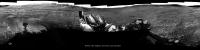
This is Jan's new panorama in circular form. Comparison with the last one shows we moved slightly to the northwest to approach the dark drifts. I will update the map tomorrow, it's been a busy day in the Solar System.
Phil
|
Posted by: Phil Stooke May 16 2019, 06:19 PM
Curiosity's dance at Aberlady-Kilmarie:

|
Phil
(the reprojections don't use a topographic map, they are not orthophotos, so each has its own distortions)
Posted by: jvandriel May 16 2019, 07:14 PM
The Navcam L view on Sol 2408.
Jan van Driel
|
|
Posted by: serpens May 16 2019, 10:29 PM
I am a touch depth challenged. Is Curiosity now at the same level as the Pettegrove Point member?
Another query that has been niggling at me is whether the extremely tough, non-drillable sections of the Jura member were higher than the drillable section. If so then could this imply that they are the eroded remnants of a lithologically distinct member that overlay the Jura.
Posted by: Phil Stooke May 16 2019, 10:51 PM
Jan's sol 2408 panorama in circular form - the drifts got scuffed.
Phil

|
Posted by: charborob May 17 2019, 06:36 PM
Sol 2408 Lmastcam view of the wheel scuff mark:

|
Posted by: djellison May 20 2019, 04:04 AM
Someone needs to stitch and animate the cloud movie on 2410
https://mars.jpl.nasa.gov/msl/multimedia/raw/?s=2410&camera=NAV_RIGHT_
It's a 3x1 mosaic, shot left to right, repeated three times without pauses.
Posted by: PaulH51 May 20 2019, 04:36 AM
Rough and ready version of this wonderful set of images
Assembled in MS-ICE /PhotoScape

|
Posted by: jccwrt May 20 2019, 05:09 AM
Here's my take on the Sol 2410 movie, assembled in Photoshop.

|
Posted by: vikingmars May 20 2019, 07:02 AM
My interpretation of the spectacular cirrus clouds seen on Sol 2410. Enjoy

|
Posted by: Sean May 20 2019, 03:32 PM
Justin kindly allowed me to tween his version of the mosaic.
4 seconds seemed to offer the best balance of movement between the 3 frames...
Click through for the animation...
https://flic.kr/p/2ez2bJH
I will update this with better quality source files soon.
Posted by: charborob May 20 2019, 07:35 PM
Sol 2411 Lmastcam view:

|
Posted by: neo56 May 20 2019, 08:33 PM
Here is my interpretation, with a color version based on typical sky hue during sunset (clouds colors may not be accurate though).
https://www.flickr.com/photos/thomasappere/47104359754/sizes/k/
https://www.flickr.com/photos/thomasappere/47104359754/sizes/k/
Posted by: jvandriel May 20 2019, 09:11 PM
The Navcam L view on Sol 2412.
Jan van Driel
|
|
Posted by: Phil Stooke May 20 2019, 09:27 PM
Very nice, Jan. Here is a circular version. A bit further ahead, just round the corner, is a place where there might be a contact between the rocks of the ridge and the clay-rich plains below. I expect it will be masked by debris, but it's the closest we are likely to get to a contact.
Phil

|
Posted by: jccwrt May 20 2019, 11:34 PM
Here's my attempt at colorizing the noctilucent cloud mosaic on Sol 2410.

|
Posted by: vikingmars May 21 2019, 07:17 AM
Actually, and based on MPF cloud images taken before sunrise, the color view should look like this.
Enjoy :
|
Posted by: atomoid May 21 2019, 10:12 PM
These have to be some of the most stunning Martian clouds observed to date.
I dissembled jccwrt's original stitch animation and repurposed the first/last frames as a crosseye/anaglyph revealing a fairly weak though still interesting stereo effect (i dont have anaglyph glasses to test it out but posted one anyways since it might be enjoyable to those who do have glasses and the crosseye method can be eyestrain inducive it seems few bother to try it out)
EDIT: attached a very scaled down parellel version rightmost fwiw.
|
|

|
|
|
Posted by: PaulH51 May 21 2019, 10:24 PM
Love all of these...
Any thoughts / estimates / wild guesses for the altitude of these wispy clouds?
What are the odds that they were captured by the Mars Webcam (VMC)? I've seen some clouds captured on the limb that appeared to be at an extremely high altitude
Posted by: ngunn May 22 2019, 08:14 AM
These are truly magnificent cloudscapes, and the 3D version does appear to show features at different levels. In particular there are sheets of cirrocumulus that look lower than the streaks of cirrus proper, most evident at the upper left of the images. There is always the risk that wind shear makes time an unreliable proxy for horizontal image separation but I am tempted to believe there are at least two layers of cloud present here.
Use of the term noctilucent cloud also raises interesting questions about atmospheric opacity, thermal structure and so on. On Earth there is a clear bimodal distribution in height separating tropospheric from mesospheric clouds with the latter appearing in very much darker skies. Nevertheless ordinary cirrus clouds high in the troposphere can also be spectacularly highlighted during twilight. How all this works in other atmospheres (Mars/Venus/Titan) would make the subject of a very interesting Planetary Society-style article.
Posted by: PaulH51 May 22 2019, 08:25 AM
Could not agree more
I was also hoping InSight would have been pointing its IDC camera south at the same time, but we've not seen any images on the landers image server since those acquired on May 16, 2019. Fingers crossed it's just a comes or server issue that will be resolved soon
Posted by: jvandriel May 22 2019, 10:23 AM
The Navcam L view on Sol 2413.
Jan van Driel
|
|
Posted by: Phil Stooke May 22 2019, 02:18 PM
What a great view that is! Here is a circular version.
Phil
|
Posted by: PaulH51 May 22 2019, 10:08 PM
The next drill site? Reached after a short drive on sol 2414
|
Posted by: atomoid May 23 2019, 01:48 AM
Brief but new https://www.nasa.gov/feature/jpl/video-fly-over-mount-sharp-on-mars/ showing our current location and the prospective route ahead winding through the clay unit and on up Gediz Vallis Channel
Posted by: charborob May 23 2019, 01:13 PM
Sol 2413 Lmastcam:
|
|
Posted by: Steve G May 23 2019, 04:14 PM
I'm pleased to see that going up Mount Sharp is still in the plans. It's taking a lot longer than what I thought it would originally and I think it will be well worth the wait. Amazing science so far.
Posted by: jvandriel May 23 2019, 06:46 PM
The Navcam L view on Sol 2414.
Jan van Driel
|
|
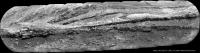
Posted by: charborob May 24 2019, 08:43 PM
Sol 2413 Lmastcam view of the top of VRR:
|
|
Posted by: serpens May 25 2019, 01:26 AM
The attempt to find a drill friendly, high potassium outcrop seems to have failed with the potassium enrichment apparently localised. Curiosity has previously discovered a number of localities with potassium content well above the Martian average and this has been impressively researched and analysed in the following link:
https://agupubs.onlinelibrary.wiley.com/doi/full/10.1002/2016JE005055
Posted by: Sean May 25 2019, 12:06 PM
Woah... 64m drive reported. Is that a record?
Posted by: Phil Stooke May 25 2019, 04:26 PM
No, the record is twice that, early in the mission.
Posted by: jvandriel May 25 2019, 05:31 PM
The Navcam L view on Sol 2416.
Jan van Driel
|
Posted by: charborob May 25 2019, 10:19 PM
Sol 2416 Lmastcam post-drive:
|
|
Posted by: Phil Stooke May 25 2019, 11:26 PM
Here is Jan's 2416 panorama in circular form. I always use images like these to establish the location for the route map.
Phil
|
Posted by: elakdawalla May 28 2019, 05:19 PM
Have any of you image magicians worked on the sol 2417 cloud animation yet?
Posted by: neo56 May 28 2019, 06:54 PM
I haven't worked on an animation yet, but here is what I obtain by stitching the first composite of the clouds:
https://www.flickr.com/photos/thomasappere/47953052808/sizes/k/
And here is what I obtain when pushing the dynamic range to its limit: nice cloudy detailed structures! However, it highlights the seams between pictures.
|
Posted by: neo56 May 28 2019, 08:17 PM
And here is the animation 
|
Posted by: neo56 May 28 2019, 08:29 PM
Here is another version of the animation with image dynamic stretched to highlight clouds structure:
|
Posted by: PaulH51 May 29 2019, 12:29 PM
Very Nice Thomas
Meanwhile in Gale: another long drive on Sol 2420 back to Woodland Bay, which I believe is just to the right of the front of the rover
MS-ICE had some issues stitching the end of drive pan, but I got a few images to make this small mosaic of left side images.
Woodland Bay was described as a very interesting laminated rock, with alternating thinner and thicker layers, and it is possible that one of these layers is the source of the pebbles we see strewn about Glen Torridon. (mission update for Sols 2416-2418) https://mars.jpl.nasa.gov/msl/mission/mars-rover-curiosity-mission-updates/?mu=sols-2416-2418-drill-no-go-time-for-plan-b
|
Posted by: charborob May 30 2019, 04:20 PM
Sol 2420 Lmastcam panorama:

|
Posted by: charborob May 30 2019, 04:22 PM
Sol 2420 Lmastcam view of the workspace (?):
|
Posted by: jvandriel May 31 2019, 10:01 AM
The Navcam L view on Sol 2420.
Jan van Driel
|
|
Posted by: jvandriel May 31 2019, 02:28 PM
and the view on Sol 2422.
Jan van Driel
|
Posted by: charborob Jun 1 2019, 02:29 PM
Sol 2422 Lmastcam post-drive view:

|
And a look at what lies close-by:
https://flic.kr/p/2g6K29R
Posted by: PaulH51 Jun 2 2019, 01:16 AM
ChemCam RMI mosaics of 3 targets in the weekend workspace acquired on sol 2424.
Many of the outcrops in this workspace have surface features that are reminiscent of desiccation cracks seen earlier in the mission
|
|
|
Posted by: Phil Stooke Jun 2 2019, 02:31 AM
Jan's two recent panoramas in circular form.
Phil
sol 2420:
|
sol 2422:
|
Posted by: PaulH51 Jun 2 2019, 11:45 AM
A very roughly stitched mosaic of a set of overlapping MAHLI frames from sol 2424 that appears to feature the Woodland Bay target.
The mosaic is somewhat distorted and I'm sure one of the regular image wizards can do a much better job at stitching these together than me and MS-ICE.
I've posted this version just to give folk a heads up and it can be deleted once a proper version is posted.
|
Posted by: jvandriel Jun 3 2019, 11:01 AM
My take on the Sol 2424 MAHLI images.
Jan van Driel
no.1
|
no.2
|
Posted by: PaulH51 Jun 3 2019, 12:05 PM
Nice
Mods can delete my rough version to save space
Posted by: serpens Jun 3 2019, 01:31 PM
[quote name='jvandriel' date='Jun 3 2019, 12:01 PM' post='244887']
My take on the Sol 2424 MAHLI images.
Bit of a problem bottom middle of no.1 Jan. Part of one Mahli image duplicated right and down.
Posted by: charborob Jun 3 2019, 01:32 PM
I see some duplication in the lower left part of your No. 1 image.
Posted by: jvandriel Jun 3 2019, 02:29 PM
Great catch serpens and charborob.
I missed it.
Thanks.
Here is the correct one.
Sol 2424 MAHLI
Jan van Driel
|
Posted by: charborob Jun 4 2019, 12:57 PM
Sol 2425 Lmastcam:
|
Posted by: jvandriel Jun 4 2019, 02:06 PM
The MAHLI view on Sol 2426.
Jan van Driel
|
Posted by: HSchirmer Jun 4 2019, 05:53 PM
Jan van Driel
|
|
With those Milkankivch-looking layers, I'd be REALLY interested to hear some first impressions from the Columbia U. crew who worked backward on the idea of a "Geological Orrey"
- Scientists Track Deep History of Planets' Motions, and Effects on Earth's Climate
Newly Forming Map of Chaos in the Solar System
https://blogs.ei.columbia.edu/2019/03/04/geological-orrery-solar-system-chaos/

Digital elevation map of sediment strata formed on a lake bottom some 220 million years ago, near present day Flemington, N.J. The lakebed was later tilted so that its cross section now faces the sky. Purple sections are ridges — remains of hard, compressed sediments formed when climate was wet and the lake deep; alternating greenish sections are lower areas made of eroded-out softer sediments from dryer times. Each pair represents 405,000 years. Groups of ridges in lower part of image manifest a separate 1.7 million-year cycle that has today grown to 2.4 million years. The 40-square-mile area is dissected by parts of the modern Raritan and Neshanic rivers (blue). (LIDAR image by U.S. Geological Survey; digital colorization by Paul Olsen)
Posted by: serpens Jun 5 2019, 01:50 AM
Given that the the Woodland Bay target is anomalous showing lamination as compared to surrounding bedrock, can we assume that it has been rotated?
Posted by: PaulH51 Jun 6 2019, 12:25 PM
Sol 2425 L-MastCam cloud survey: Used GIMP/G'MIC-Qt/Repair/Bayer reconstruction. No additional processing, then roughly assembled in MS-ICE (see top version)
Then I used a bucket full of artistic licence adjusting the colours and made the version at the bottom for fun
Hoping someone can join some of the other images from the large set as unsurprisingly MS-ICE did not enjoy working with these wispy evening clouds, and maybe provide a better interpretation of what the colours will have looked like
|
EDIT: Well I did not have to wait long: Damia has issued the full mosaic on her blog, it does not disappoint
http://www.db-prods.net/marsroversimages/Curiosity/2019/Sol2425_Mastcam34.jpg
Posted by: jvandriel Jun 8 2019, 12:36 PM
The Navcam L view on Sol 2429.
Jan van Driel
|
|
Posted by: charborob Jun 8 2019, 05:05 PM
Sol 2429 Lmastcam:

|
Posted by: Phil Stooke Jun 8 2019, 05:11 PM
Thanks, Jan. That shows we have left Woodland Bay and moved out into the plains again, south of where the last samples were taken. There is a nice bit of outcrop nearby, so maybe a new target. Here's a circular view of the area from Jan's panorama.
Phil
|
Posted by: charborob Jun 10 2019, 04:28 PM
Midnight planets seems to be stuck on sol 2430, so from the MSL raw images page, here is the debayered view of an interesting hillock. Sol 2431 Rmastcam:
|
Posted by: PaulH51 Jun 11 2019, 01:05 PM
2432 post drive workspace (L-MastCam) MS-ICE otherwise unprocessed
|
Posted by: charborob Jun 11 2019, 01:55 PM
Sol 2432 Lmastcam:

|
Posted by: jvandriel Jun 11 2019, 02:38 PM
The Navcam L view on Sol 2432.
Jan van Driel
|
|
Posted by: Phil Stooke Jun 11 2019, 05:45 PM
Here's Jan's panorama in circular form. Comparison with the last shows how we are moving along the outcrop to a better exposure.
Phil
|
Posted by: PaulH51 Jun 13 2019, 02:55 AM
And another good drive on sol 2434 take Curiosity closer to "Waypoint 4" (refer to this mission update https://mars.jpl.nasa.gov/msl/mission/mars-rover-curiosity-mission-updates/?mu=sol-2434-ridge-rage) L-NavCam partial pan roughly assembled in MS-ICE
|
Posted by: jvandriel Jun 13 2019, 11:51 AM
The Navcam L view on Sol 2434.
Jan van Driel
|
Posted by: jvandriel Jun 13 2019, 12:04 PM
and a partial view of the Sol 2434 Navcam L panorama.
Jan van Driel

|
Posted by: PaulH51 Jun 14 2019, 01:16 AM
Another drive on Sol 2435 - NLB partial pan
Skirting around 'Waypoint 4'? Very poorly stitched in MS-ICE
|
Posted by: Phil Stooke Jun 14 2019, 02:17 AM
Jan's new panorama for sol 2434 in circular form.
Phil
|
Posted by: jvandriel Jun 14 2019, 10:04 AM
The Navcam L view on Sol 2435.
Jan van Driel
|
|
Posted by: PaulH51 Jun 15 2019, 01:57 AM
Sol 2436 - 10 frame RMI mosaic assembled in MS-ICE. Features some rocks atop the nearby ridge
|
Posted by: jvandriel Jun 15 2019, 02:01 PM
The Navcam L view on Sol 2436.
Jan van Driel
|
Posted by: Phil Stooke Jun 16 2019, 04:01 AM
These are the last two panoramas from Jan in circular form. We are moving down a valley between ridges and the outcrop seen in recent images is on the east side of the valley a bit further south of us.
Phil
Sol 2435:
|

|
Posted by: PaulH51 Jun 16 2019, 10:47 AM
Sol 2437: 6 frame R-MastCam mosaic bayer repaired in GIMP, assembled in MS-ICE, no further processing.
|
|
Posted by: PaulH51 Jun 17 2019, 10:32 AM
And another drive on Sol 2439
Here is a few of the L-NavCams from the drive assembled into a GIF, looks like it might have been a drive up to the ridge

|
Posted by: Sean Jun 17 2019, 06:31 PM
ooh....http://www.midnightplanets.com/web/MSL/image/02438/NRB_613927069EDR_S0760832NCAM00595M_.html Sol 2438 NR
Posted by: fredk Jun 17 2019, 07:18 PM
Cosmic ray hit, probably. No hint of anything at that location in the frames just before and after that one.
Posted by: PaulH51 Jun 18 2019, 11:04 AM
The stitching may be ugly on this Sol 2439 L-NavCam partial pan, but the vista from the top of the ridge makes up for it.
As usual MS-ICE butchered the stitching, but hopefully it will inspire someone to do a better job.
Joe Knapp's page puts the roll/pitch at +15°/+17° which must be up there on the leader board for a combined total
|
Posted by: jvandriel Jun 18 2019, 02:14 PM
The Navcam L view on Sol 2439.
Jan van Driel
|
Posted by: Phil Stooke Jun 18 2019, 08:47 PM
A circular version of Jan's panorama shows us perched nicely on the ridge. This should be OK for contact science (APXS) but not drilling on a slope like this.
Phil
|
Posted by: charborob Jun 19 2019, 05:47 PM
Sol 2439 Lmastcam:
|
Posted by: serpens Jun 20 2019, 03:50 AM
Very nice indeed Charbob. It may be simply an artifact of the viewing angle combined with preferential erosion, but it looks like some low angle cross bedding there.
Posted by: PaulH51 Jun 20 2019, 07:59 AM
The team also think there is some cross-bedding
https://mars.jpl.nasa.gov/msl/mission/mars-rover-curiosity-mission-updates/?mu=sol-2441-2442-so-much-to-do-before-the-holidayPosted by: jvandriel Jun 20 2019, 07:13 PM
The MASTCam R view on Sol 2441.
Jan van Driel

|
Posted by: PaulH51 Jun 22 2019, 12:45 AM
Possibly an inclusion (pebble)
Probably just wishful thinking
|
Posted by: serpens Jun 22 2019, 07:10 AM
I don't think it is a clast Paul, but what would I know. Heck, I can't even decide whether this little fella is a clast or a blow in.
|
Posted by: PaulH51 Jun 22 2019, 12:44 PM
Hmmmm good question. It's one of those I would not bet on either way
Lot's of eye candy atop this little ridge
Posted by: jvandriel Jun 23 2019, 01:10 PM
The MASTCam R view on Sol 2443.
Jan van Driel
|
|
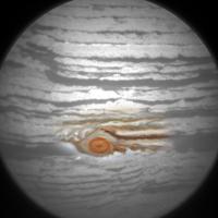
Posted by: Phil Stooke Jun 23 2019, 07:48 PM
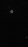
RMI took an image of Jupiter - quite impressive!
Phil
|
Posted by: nprev Jun 24 2019, 02:42 AM
....aaaand Phil wins the coveted "Pareidolia Of The Year" award. Nicely done! 
Posted by: serpens Jun 24 2019, 02:45 AM
Now that is clever.
Posted by: PaulH51 Jun 26 2019, 12:55 AM
A shortish drive on Sol 2447. from the thumbnail drive images it looks like the drove back down the slope following the wheel tracks then turned towards the Southwest.
Not many post drive images yet, but here's a nice one looking back up towards the ridge and across Glen Torridon.
|
Posted by: jvandriel Jun 26 2019, 01:06 PM
The Navcam L view on Sol 2447.
Jan van Driel
|
Posted by: Phil Stooke Jun 26 2019, 06:05 PM
Jan's nice panorama in circular form. We drove off the ridge and will soon move further south.
Phil

|
Posted by: jvandriel Jun 27 2019, 09:23 AM
The Navcam L view on Sol 2448.
Jan van Driel
|
Posted by: jvandriel Jun 28 2019, 11:01 AM
The MASTcam L view on Sol 2440.
Jan van Driel
|
Posted by: jvandriel Jun 28 2019, 02:12 PM
and the Navcam L view on Sol 2449.
Jan van Driel
|
Posted by: Phil Stooke Jun 28 2019, 06:29 PM
Circular versions of some of Jan's recent panoramas. I can hardly keep up right now!
Phil
sol 2447:
|
sol 2448:
|
sol 2449:
|
Posted by: jvandriel Jun 30 2019, 02:04 PM
The MASTCam L view on Sol 2441-2443-2446.
A total of 205 images Debayered and stitched.
Jan van Driel
|
Posted by: serpens Jun 30 2019, 10:49 PM
Beautiful work Jan.
Posted by: marsophile Jul 1 2019, 02:53 AM
That light-toned material looks quite striking (in a hollow near the upper center of the image).
A crop from Jan's image:
|
Posted by: jvandriel Jul 1 2019, 01:26 PM
Sol 2447.
The MASTCam R looking SE.
Jan van Driel
|
Posted by: serpens Jul 2 2019, 10:50 PM
Pediment protected by allochthonous detritus (likely), lithified alluvial fan or deltaic?
Posted by: jvandriel Jul 3 2019, 09:41 AM
The Navcam L view on Sol 2453.
Jan van Driel

|
Posted by: jvandriel Jul 3 2019, 09:57 AM
and the MAHLI view on Sol 2453.
Jan van Driel

|
Posted by: charborob Jul 3 2019, 10:39 AM
Sol 2453 Lmastcam post-drive view:
|
Posted by: charborob Jul 3 2019, 06:38 PM
Sol 2454 Lmastcam view:
|
Posted by: Phil Stooke Jul 4 2019, 04:09 AM
Jan's sol 2453 panorama in circular form. Out of the valley and up onto the rocky hill.
Phil
|
Posted by: jvandriel Jul 4 2019, 10:09 AM
The Navcam L view on Sol 2454.
|
Posted by: Phil Stooke Jul 4 2019, 11:52 PM
And a circular version of Jan's sol 2454 panorama. Com paring it with the last one shows how we have moved to the southwest a bit.
Phil
|
Posted by: PaulH51 Jul 8 2019, 08:18 AM
A short wheel check drive during Sol 1459. Roughly assembled L-NavCam partial pan of the view in front of the rover
|
Posted by: jvandriel Jul 8 2019, 11:59 AM
The Navcam L view on Sol 2459.
Jan van Driel
|
Posted by: jvandriel Jul 9 2019, 09:56 AM
The MASTCam L view on Sol 2458.
Jan van Driel
|
|
Posted by: charborob Jul 9 2019, 10:22 AM
Sol 2459 Lmastcam:
|
Posted by: PaulH51 Jul 9 2019, 11:28 AM
2459 post drive workspace (processed L-MastCam)
|
Posted by: jvandriel Jul 9 2019, 01:50 PM
The Mastcam L images taken on Sol 2455 and Sol 2458
Debayered and stitched.
Jan van Driel
|
|
Posted by: jvandriel Jul 9 2019, 02:41 PM
Added also the MASTCam L images taken on Sol 2457.
Jan van Driel
|
|
Posted by: jvandriel Jul 9 2019, 02:45 PM
Added also the MASTCam L images taken on Sol 2457.
Jan van Driel
|
|
Posted by: Steve G Jul 9 2019, 09:42 PM
I definitely cannot pronounce half those words. Now I'll look up what they mean.

Posted by: Phil Stooke Jul 9 2019, 10:38 PM
Nice Mastcam mosaics everyone! Here is Jan's sol 2459 panorama in circular form.
Phil
|
Posted by: charborob Jul 11 2019, 12:30 AM
Sol 2462 Mahli view of the rocks:
|
(Photoshop could'nt stitch all the images. Three were left out.)
Posted by: PaulH51 Jul 12 2019, 02:48 AM
Short drive on sol 2463: post drive partial L-NavCam pan, roughly assembled in MS ICE
|
Posted by: PaulH51 Jul 12 2019, 06:13 AM
Curiosity Sol 2463 end of drive stowed MAHLI. It's been a while since we had one of these
|
Posted by: jvandriel Jul 12 2019, 10:51 AM
The complete MAHLI view on Sol 2462.
( 18 images )
Jan van Driel
|
Posted by: jvandriel Jul 12 2019, 02:40 PM
The Navcam L view on Sol 2463.
Jan van Driel
|
Posted by: Explorer1 Jul 13 2019, 02:03 AM
Great new HiRISE image from May 31, showing the mast!
https://www.jpl.nasa.gov/news/news.php?feature=7453
Posted by: fredk Jul 13 2019, 07:30 PM
The emission angle is only 10.6 deg for that shot, so isn't the turret more likely? Knowing what azimuth the camera view was from (ie 10.6 deg in which direction?) and where the turret was at that time should decide it.
Posted by: djellison Jul 14 2019, 01:47 AM
The end of the arm is largely dark. That's the top of the ChemCam housing on the RSM - no doubt about it.
It was Sol 2423 for MSL
Images
https://mars.jpl.nasa.gov/msl/multimedia/raw/?s=2400#/?slide=2423
Plan Description
https://mars.jpl.nasa.gov/msl/mission/mars-rover-curiosity-mission-updates/?mu=sols-2422-2423-familiar-rocks-at-our-feet
"Then on the second sol ChemCam will acquire observations on 2 autonomously selected AEGIS targets, along with some Navcam dust devil and suprahorizon observations to monitor the atmosphere."
It's the second sol of a 2 sol plan that had a drive on the first sol - therefore the arm remains stowed.
That includes a ChemCam AEGIS block (Navcam images with a CCAM sequence ID are AEGIS) a dust devil movie and supra-horizon movie, and then the RSM would have stowed - which is 0az, -48 deg in rover frame. i.e. pointing forward and down.
The arm was stowed at the time it was taken.
Posted by: charborob Jul 14 2019, 11:14 PM
Sol 2464 Lmastcam debayered:
|
Posted by: Phil Stooke Jul 15 2019, 02:56 AM
Jan's sol 2463 panorama in circular format, another small drive on the rocky hill. I'm running a bit slow on the map update as I am roughing it in the bush at Ucluelet on Vancouver Island. Spent the day on Long Beach... it's a tough life being retired. Map update will follow when i can get to it.
Phil
|
Posted by: PaulH51 Jul 15 2019, 03:55 AM
The MSL web pages have recently been modified (upgraded?)
Like many I'm not a fan of change part way through a mission but I'll likely warm to the revised format eventually. But that is not the reason for this post.
The image server changes may have had a serious effect on Midnight Planets and Joe Knapp's image pages. Unless they have both have had issues at the same time
There are recent images on JPL's server that are missing from both Midnight Planets and Joe's page. Sol dates look OK, but published dates appear to have reset to the beginning of 2000. Selecting thumbnails on MP's sol 2466 page goes straight to 404 errors (both on PC and APP versions). Joe's 2466 page has no thumbnails, just image placeholders.
The new 'whereistherovernow' page has all the map thumbnails, but clicking any of the recent maps gives 404 page errors.
Hopefully these are just teething problems with the new design that will be fixed soon, but not sure if fixing those teething issues will fix Joe's and MP pages.
Posted by: fredk Jul 15 2019, 02:01 PM
Joe's site has been showing only mahli images for a couple of weeks now, so there seems to have been a different problem there.
But a completely new official public image site would mean both Joe and MP would need to completely rewrite their image harvesting code, I'd think. That's a big job.
Posted by: jvandriel Jul 15 2019, 02:51 PM
The Navcam L view on Sol 2466.
Jan van Driel
|
Posted by: mcaplinger Jul 15 2019, 06:40 PM
Are you saying that there's something on https://mars.jpl.nasa.gov/msl/multimedia/raw that is actually wrong, or just that the page format changed? If there's an actual problem then you should report it to https://mars.jpl.nasa.gov/feedback/
Powered by Invision Power Board (http://www.invisionboard.com)
© Invision Power Services (http://www.invisionpower.com)