Printable Version of Topic
Click here to view this topic in its original format
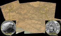
Unmanned Spaceflight.com _ MSL _ The Top of Vera Rubin Ridge Part 1
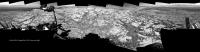
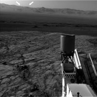
Posted by: PaulH51 Sep 11 2017, 09:50 AM
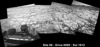
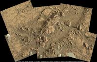
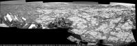
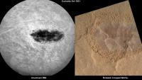
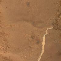
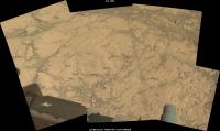
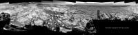
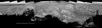
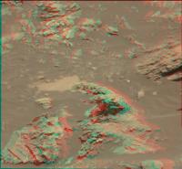
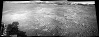
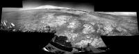
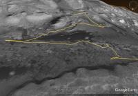
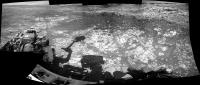
Welcome to Route 66... Er, make that Site 66 
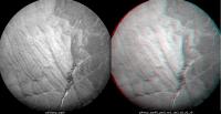
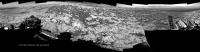
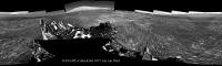
Drive 0000 on Sol 1812. Roughly stitched L-NavCam using MS ICE
Midnight Planets reporting it as ~5.6m ESE (115º) https://twitter.com/MidnightLoader/status/907124787012620288
|
Posted by: elakdawalla Sep 11 2017, 08:19 PM
A new site seems like a good spot to make the split to a new thread.
Posted by: PaulH51 Sep 13 2017, 05:15 AM
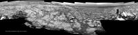
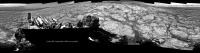
After the short drive on sol 1814 here's a quick-n-dirty NLB 360 pan, Please delete when the complete version is posted, this may help fix the location.
|
|
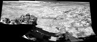
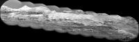
Posted by: jvandriel Sep 13 2017, 09:28 AM
The Navcam L view on Sol 1814.
Jan van Driel
|
Posted by: jvandriel Sep 13 2017, 09:49 AM
and the view looking back ( North ) on Sol 1814.
Jan van Driel
|
|
Posted by: serpens Sep 13 2017, 11:01 PM
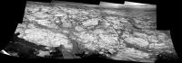
The really fine laminations indicate suspension fallout in reasonably deep still water, so the crater was experiencing a wet environment when this level was laid down. Given the original permeability of the deposits my horribly unreliable intuition suspects that the hematite developed during a dry cycle via a mixing interface between groundwater and water infiltrating from a disconnected stream, fed by acidic meltwater at the beginning of the volcanic period that gave rise to the sulphate formation. Development in an open rather than closed environment.
|
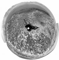
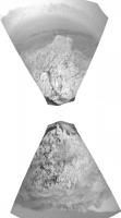
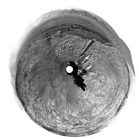
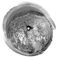
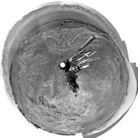
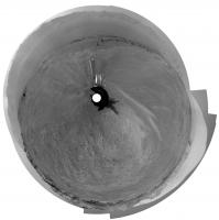
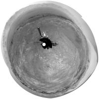
Posted by: Phil Stooke Sep 14 2017, 06:24 AM
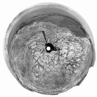
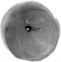
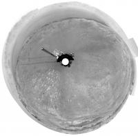
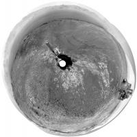
One of Jan's panoramas in circular form.
Phil
|
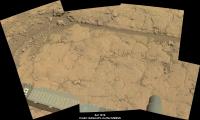
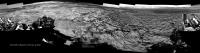
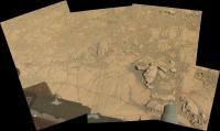
Posted by: PaulH51 Sep 14 2017, 08:03 AM
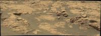
Sol 1814 post drive workspace, assembled in MS ICE, raw colour, no additional processing.
|
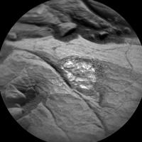
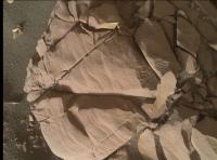
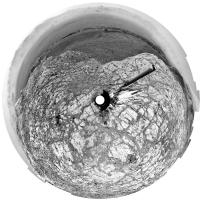
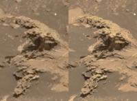
Posted by: Floyd Sep 14 2017, 11:39 AM

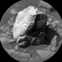
I assume the spot was cleared of dust by laser blasts, not by brushing? If so I don't think I have ever seen this type of cleaning. Might the shiny surface be hematite? Not berries, but sheets???
Posted by: PaulH51 Sep 14 2017, 09:30 PM
It appears to be LIBS of an AEGIS target. Here is the before and after LIBS. The eroded surface seems to have small 'facets' for want of a better description. Certainly an interesting site...
|
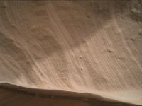
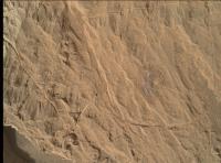
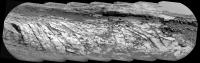
Posted by: serpens Sep 16 2017, 01:18 AM
Specular reflections which is a pointer to crystalline minerals. Given that this is the hematite cemented ridge we could punt for hematite / goethite.
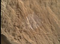
Posted by: PaulH51 Sep 16 2017, 08:31 AM
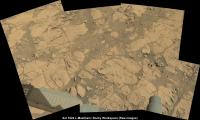
2 MAHLI's from Sol 1816 of the fractured sedimentary bedrock in front of the rover. The first is a context frame, the second is a focus merged product of the center of the context frame. The surface dust is more abundant on certain areas, probably just on the 'flatter sections' but at first glance I thought is was concentrated at specific laminations
|
|
Links http://mars.jpl.nasa.gov/msl-raw-images/msss/01816/mhli/1816MH0001900010701386C00_DXXX.jpg and http://mars.jpl.nasa.gov/msl-raw-images/msss/01816/mhli/1816MH0001930000701417R00_DXXX.jpg
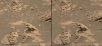
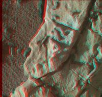
Posted by: PaulH51 Sep 16 2017, 11:48 AM
ChemCam RMI Z-stack & red/cyan anaglyph of fine laminations in the target "Phoney Island".
Assembled using the 7 'https://mars.jpl.nasa.gov/msl/multimedia/raw/?s=1817&camera=CHEMCAM_' posted by JPL of the 9 RMI frames acquired, it may be possible to pull some more detail from all 9 if the missing 2 turn up as enhanced files. I used http://www.picolay.de/ to assembled the Z-Stack and the anaglyph shown here. I'm sure https://mars.jpl.nasa.gov/msl/mission/mars-rover-curiosity-mission-updates/?mu=sol-1815-1816-stopping-to-smell-the-rocks will be much better than this basic version, but it was fun making it
|
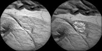
Posted by: HSchirmer Sep 16 2017, 12:38 PM
|
|
Curious, raindrop mark?
|
Posted by: serpens Sep 17 2017, 11:48 PM
After all those fine laminations, now for somethiing a little different.
|
Posted by: PaulH51 Sep 18 2017, 05:23 AM
Hmmmmm definitely different
Looks rather complex, so better get back to the fine laminations
|
A simple 12 frame HazCam animation of some of the arm work at the current location, hopefully I interpreted the target names correctly from the Mission Update
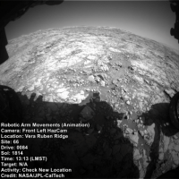
|
Link in case animation wont play https://i.imgur.com/gIMNA39.gif
Posted by: jvandriel Sep 18 2017, 07:09 PM
The Navcam L view on Sol 1819.
Jan van Driel
|
|
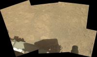
Posted by: charborob Sep 19 2017, 05:27 PM
The Lmastcam view on sol 1819:
https://flic.kr/p/XCN48P
Posted by: PaulH51 Sep 20 2017, 06:54 AM
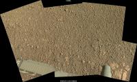
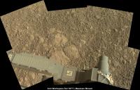
Sol 1819 Workspace from the left MastCam (Raw in MS ICE)
|
Note some lovely colour variations when you stretch the colours, and is that another little iron meteorite in the upper left? Or is that just my wishful thinking
Posted by: PaulH51 Sep 20 2017, 07:30 AM
Well I can't claim to have seen a reaction like that to a ChemCam LIBS session  )
)
The plan for Sol 1821 has several ChemCam targets, but this is a first to come down, maybe they turned up the power to celebrate the 500k shot of the laser
|
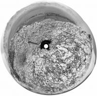
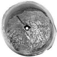
Posted by: Phil Stooke Sep 20 2017, 11:18 AM
Yes, that does look interesting.
This is Jan's panorama for sol 1819 in circular form. The rocky pavement is a big change from so many sols among broken rocks.
Phil
PS - I'm in Salisbury, UK for the next few weeks. If any UMSF fans want to meet up send me a message.
|
Posted by: jasedm Sep 20 2017, 07:59 PM
Phil, it would be great to meet up for a natter re all things umsf and (horrors!) msf..... I live less than 30 miles from Salisbury, and Ian Regan is Plymouth-based, perhaps we could have a mini-summit. Any other umsf'ers that could make it while Phil's in the UK?
Posted by: PaulH51 Sep 21 2017, 03:17 AM
Looks like we can add another small iron meteorite to the list

|
Sol 1821, not got the R-MastCam context frame yet.
Posted by: Phil Stooke Sep 21 2017, 09:36 AM
That really does look like a meteorite! From the update, it is called Mustards Island.
Phil
(PS - I am replying to jasedm privately but if anyone else is nearby, send a message)
Posted by: PaulH51 Sep 21 2017, 03:34 PM
Only one ChemCam-RMI image of Mustard Island came down (so far), so looks like it was not zapped, even though it was inside the range of the laser, so I guess we'll never know for sure, but I'm still calling it a meteorite
EDIT: strike that comment, they did zap it http://www.lanl.gov/discover/news-release-archive/2017/September/0921-chem-cam-500k-shots.php and that zap took the laser hits above 500k
Posted by: PaulH51 Sep 22 2017, 02:25 AM
Quick and dirty partial pan of the L-NavCams after the nice drive on sol 1822. Mods can delete after the full version is posted. Some long awaited views of the distant target destinations gradually coming into view
|
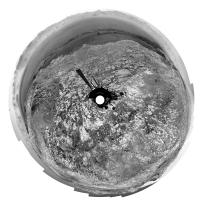
Posted by: jvandriel Sep 22 2017, 02:18 PM
The Navcam L view on Sol 1822.
Jan van Driel
|
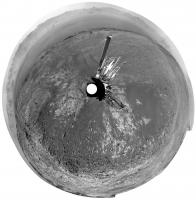
Posted by: Phil Stooke Sep 22 2017, 02:54 PM
Thanks, Jan. Here it is in circular format.
Phil
|
Posted by: charborob Sep 22 2017, 07:08 PM
The sol 1822 Lmastcam view:
https://flic.kr/p/XJrNzK
Posted by: PaulH51 Sep 22 2017, 10:17 PM
Latest L-MastCam workspace assembled in MS ICE (Sol 1822)
|
Posted by: Phil Stooke Sep 23 2017, 12:48 PM
Apparently we are now in a new quadrangle. Names from the latest status report include Sherwood Forest and Troll Valley, taken from the 1883 novel The Merry Adventures of Robin Hood by Howard Pyle. Previous quads took names from geological features of the areas which gave the quads their names. I don't know what this quad will be named. If anyone can fill us in, I would be grateful.
Phil
Posted by: PaulH51 Sep 24 2017, 06:25 AM
)I believe this may be https://mars.jpl.nasa.gov/msl-raw-images/msss/01821/mhli/1821MH0001220010701544C00_DXXX.jpg of the sol 1821 odd looking ChemCam target I posted a few days back. Rotated & cropped, in raw colour and presented side-by-side with the RMI. Looks like the liberal coating of dust and the darker bedrock gave us the interesting B&W image
|
Posted by: serpens Sep 24 2017, 07:04 AM
That does seem to be the target, good eyes there Paul. The RMI operating range is 400 nm to 840 nm so there was possibly a big spike in one section of the reflectance spectra.
Posted by: PaulH51 Sep 25 2017, 03:34 AM
Thanks for the tip on the camera's optical range and the possible spike
Posted by: PaulH51 Sep 25 2017, 10:51 AM
I think this sol 1822 ChemCam target is https://mars.jpl.nasa.gov/msl/mission/mars-rover-curiosity-mission-updates/?mu=sol-1822-onward-and-upward, I added the R-MastCam context image as well as a small mosaic of R-NavCam images to the 4 frame RMI mosaic. AlgorimancerPG was used to create the scale bar.
|
Posted by: PaulH51 Sep 27 2017, 04:47 AM
Quick and Dirty R-NavCam after the short drive on 1827.
Page mods can delete when the good version is posted
|
|
Posted by: serpens Sep 27 2017, 05:09 AM
Well the depositional environment is certainly changing as we get closer to the top of the ridge.
Posted by: monty python Sep 27 2017, 06:32 AM
Almost looks like tree rings. Very uniform in thickness I think. Seasonal?
Posted by: jvandriel Sep 27 2017, 09:50 AM
The Navcam L view on Sol 1827.
Jan van Driel
|
|
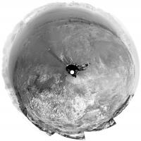
Posted by: Phil Stooke Sep 27 2017, 03:00 PM
A circular view of Jan's new panorama. Soon enough - a month or two perhaps - and we will be looking into the stunning terrain south of the ridge.
Phil
|
Posted by: HSchirmer Sep 27 2017, 03:33 PM
Well, perhaps not "seasonal' as in every martian year, but perhaps "recurrent" as in 51k earth year, procession.
Posted by: serpens Sep 28 2017, 03:54 AM
There are a number of factors that could have influenced bedding formation that are not necessarily cyclical. For example changes in the sources of sediment and variations in sediment supply, water depth and velocity, changes in climate or local environment, wind velocity and direction if aeolian, airfall from volcanic activity or impacts and so on. There should be some interesting papers in the next LSPC.
Posted by: PaulH51 Sep 28 2017, 08:47 AM
R-MastCam from 1821 which is the context image for the ChemCam target called 'Mustards Island'. We can see the LIBS locations as bright specs which are very similar to earlier LIBS sites on iron meteorites, but I've not yet seen any reports from JPL, I guess we have to await a paper, or a Photo Journal post
Using AlgorimancerPG I get a width of ~6 cm.
|
Posted by: jvandriel Sep 28 2017, 06:27 PM
The Navcam L view on Sol 1828.
Jan van Driel
|
Posted by: djellison Sep 28 2017, 07:15 PM
Yeah - that was a fun shift yesterday (1829) - did my best to raise the drive direction (ncam00267) to cover Mt Sharp without getting a hole in coverage between it, the Workspace (ncam00375) and the ChemCam targetable region (ncam00312) - a lot of back and forth, relying on an end of drive pitch/tilt to make it work.
Super relieved that it all worked out
Posted by: jvandriel Sep 28 2017, 09:33 PM
and the view on Sol 1829.
Jan van Driel
|
|
Posted by: charborob Sep 29 2017, 03:32 AM
The sol 1828 Lmastcam drive direction view:
https://flic.kr/p/YXqWAP
Posted by: PaulH51 Sep 29 2017, 04:22 AM
R-MastCam from 1828 I think this is https://mars.jpl.nasa.gov/msl/mission/mars-rover-curiosity-mission-updates/?mu=sol-1828-bye-bye-bar-harbor (raw in MS ICE)
|
Posted by: Phil Stooke Sep 29 2017, 11:22 AM
The view is getting stunninger and stunninger (for one as easily stunned as me). Here are Jan's two latest panoramas in circular form.
Phil
sol 1828:
|
Sol 1829:
|
Posted by: jvandriel Sep 29 2017, 02:32 PM
The Navcam L view on Sol 1830.
Jan van Driel

|
Posted by: Phil Stooke Sep 29 2017, 03:55 PM
Very nice! Here it is in circular form.
Phil
|
Posted by: charborob Sep 29 2017, 04:10 PM
The sol 1829 Lmastcam drive direction view:
https://flic.kr/p/YVBpD9
Posted by: serpens Sep 30 2017, 03:27 AM
Probably a superb image Charborob, but unfortunately Flic.kr is yet again declining to play.
Posted by: PaulH51 Sep 30 2017, 03:59 AM
A roughly assembled version of the same images, but using a different projection than Charborob (assembled using MS ICE, with no additional processing)
|
|
Posted by: charborob Sep 30 2017, 04:19 PM
Don't know what the problem could be. Il works for me when I click on the image.
Posted by: charborob Sep 30 2017, 05:25 PM
Sol 1830 Lmastcam view (compressed):
|
and the Flickr link: https://flic.kr/p/YVSHPw (hope this works)
Posted by: PaulH51 Sep 30 2017, 11:22 PM
A pair of rather interesting ChemCam Targets from sol 1831, shown in context on a resized version of the L-MastCam workspace from 1830
The https://mars.jpl.nasa.gov/msl/mission/mars-rover-curiosity-mission-updates/?mu=sol-1831-quite-a-diffracting-weekend refers to them as "Normandien," and "Black Reef."
Besides the interesting shapes, any thoughts on the small surface pits?
|
|
|
Posted by: serpens Oct 1 2017, 02:51 AM
Beautiful Paul (both the image quality and the view). Thank you.
Posted by: nprev Oct 1 2017, 09:59 AM
Strange little beasts. Normandien appears to be shot through with crack-filling intrusions of white material, so possibly metamorphized. The pits may have been inclusions of some other mineral that either evaporated out during the metamorphism or eroded away after the rock reached the surface.
(Sheer guesses; let's see what the real geologists say. )
Posted by: HSchirmer Oct 1 2017, 09:40 PM
|
|
I've seen voids like that in red mudstone, usually casts of carbonate or salt crystals that later dissolved.
Hmm, micro-kettles when the loss inclusions salt, water ice or dry ice create voids?
What sort of stability do water ice or dry ice have at the guesstimated deposition temperatures and pressures?
Posted by: serpens Oct 1 2017, 10:33 PM
I think we need to wait and see what this little fellow is made of. While there may have been a few kilometres of sedimentary material covering this area in the past there would not be anywhere near the heat or pressure necessary for metamorphism. Could the apparent veining on the sunlit side be an artefact of reflectance?
Posted by: PaulH51 Oct 2 2017, 12:49 AM
We now have the R-MastCam frames of the two interesting 1831 ChemCam targets:
|
|
Posted by: serpens Oct 2 2017, 01:43 AM
Given that we are still on a slope climbing towards the top of the ridge and these probably bounced down from a higher level, it wouldn't surprise to find that "Black Reef" is a chip off the old block so to speak.
Posted by: algorithm Oct 2 2017, 07:18 PM
Only two in the immediate vicinity? If they were tumbling from above, wouldn't there be more? Having said that I don't know what "the immediate vicinity" is . Certainly seems to me to be out of context with their current location, very interesting that one seems to be a 'longer baked, bigger version, more developed', call it what you will, version of the other. Perhaps one arrived at it's current location long before the other?
Geology....madness solidified, I don't know how you do it!
Posted by: HSchirmer Oct 2 2017, 11:41 PM
"Architecture is solid music" - von Goethe
"Geology is solid climatology" - me
Posted by: serpens Oct 3 2017, 12:00 AM
I would amend that to read " Sedimentary geology is solid climatology" - you.
I was in fact mulling over the possibility that "Black Reef" parted from "Normandien" on the way down, along a fracture. We have seen a few instances of this with float. For example, this three piece jigsaw.

|
Posted by: PaulH51 Oct 3 2017, 06:14 AM
Arm/drill issues after placing a sample from Ogunquit Beach in CheMin prevented the drive on sol 1833. That presented an opportunity to take another look at Normandien with ChemCam in Passive mode. It also meant the rover acquired a set of NavCam images with the arm extended
MS ICE managed to assemble these three frames. 'Curiosity looking back at its path', I hope others will properly assemble these.
|
Posted by: Gerald Oct 3 2017, 07:03 AM
...
To my limited geological experience, this looks remotely reminiscent of eroded stalagmites. Clay-loaded cool liquid dropping on a warmer ground would dry rapidly, form uneven layers, and might form small drying bubbles by outgassing or boiling.
As usual in hugely underdetermined data sets, that's just one of an arbitrary number of options.
Posted by: Phil Stooke Oct 3 2017, 10:26 AM
To add to the range of possibilities... it was suggested that these rocks fell down the slope from higher layers, but I would point out an alternative direction of movement - impact ejecta thrown up from the plains to the north, or even from much further afield. If the material was impact melt, solidifying in flight, the holes might be vesicles (bubbles). Not saying it has to be that, I just want to add to the confusion.
Phil
Posted by: jvandriel Oct 3 2017, 01:51 PM
The Navcam L view on Sol 1833.
Jan van Driel
|
Posted by: PaulH51 Oct 4 2017, 01:09 AM
Drive of approximately 13.9m SSE (147º) on Sol 1834 (Oct 3, 2017) http://www.midnightplanets.com/web/MSL/sol/01834.html
Very roughly processed and roughly stitched partial pan assembled in MS ICE using the L-NavCam's... Poor processing, but a great view
|
Posted by: Phil Stooke Oct 4 2017, 03:10 PM
Sol 1834 Hazcams reprojected to find the location after the drive - not always good enough, but today they work just fine.
Phil
PS I just spent an enjoyable afternoon with ngunn, a very nice chat about all things UMSF.
|
Posted by: jvandriel Oct 4 2017, 03:10 PM
The Navcam L view on Sol 1834.
Jan van Driel
|
Posted by: vikingmars Oct 4 2017, 07:29 PM
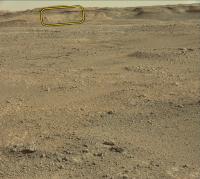
On the latest NavCam pics, and due to the low opacity of the Martian atmosphere and our climbing the hills, we are beginning to see clearly some far horizon features (herewith a Sol 1834 pic).
Dear Phil, as our talented Cartographer-in-Chief, could you please give us your opinion with a location on a map ?
Thanks so much in advance
|
Posted by: fredk Oct 4 2017, 08:13 PM
Those look like the same features Phil identified in http://www.unmannedspaceflight.com/index.php?s=&showtopic=8309&view=findpost&p=236966
Posted by: vikingmars Oct 5 2017, 07:01 AM
Thanks a lot fredk for the link... and also to Phil for his good map
Posted by: PaulH51 Oct 5 2017, 07:23 AM
Sol 1834 L-MastCam Arm Workspace (Raw in MS ICE)
|
Posted by: jvandriel Oct 5 2017, 09:49 AM
The Navcam L view on Sol 1834. (Added 1 Right Navcam image)
Jan van Driel

|
Posted by: charborob Oct 5 2017, 11:21 AM
Sol 1834 Lmastcam view:
https://flic.kr/p/Z5rXwN
Posted by: PaulH51 Oct 6 2017, 12:47 PM
One of sol 1836 DRT targets has some lighter toned areas within the brushed zone (not the calcium sulfate veins). I thought maybe these were DRT scouring on the high spots on a soft rock target, however another MAHLI of the same target after the LIBS array, but prior to the DRT appears to show some of the light toned areas may have been present before the DRT brushed the target. The raw images are attached. One of the LIBS sites may have hit the edge of a light toned area, so it may be interesting to review the spectra once released
|
|
Links to raw images https://mars.jpl.nasa.gov/msl-raw-images/msss/01836/mhli/1836MH0001900010701832C00_DXXX.jpghttps://mars.jpl.nasa.gov/msl-raw-images/msss/01836/mhli/1836MH0001900010701824C00_DXXX.jpg
Posted by: Fran Ontanaya Oct 7 2017, 07:57 PM
I think she's getting a bit creative with her ChemCam laser. 
|
Posted by: serpens Oct 8 2017, 12:02 PM
Now this is interesting. Reduction spots in hematite rich sandstone, with the lack of sphericity probably indicating formation pre-compaction. I don't know if it is possible to get any indication of the mineral in the cores but some of the possibilities are fascinating.
|
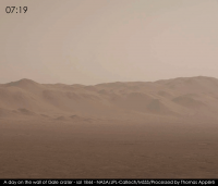
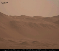
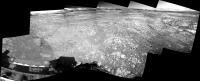
Posted by: neo56 Oct 8 2017, 02:50 PM
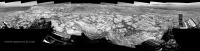
My take on the beautiful MC34 panorama of sol 1812, while climbing the ramp to top:
https://www.flickr.com/photos/thomasappere/36901484073/sizes/o/
And panorama taken with NavCam Left on sol 1833 patched with pictures taken on sol 1834, with a sky adapted from scalbers' work:
https://www.flickr.com/photos/thomasappere/36857019984/sizes/o/
You can explore it in Virtual Reality https://roundme.com/tour/204804/view/553595/.
Does someone know a sol where the rover would have taken a picture of its turret in the same orientation as on sol 1833? So that I can fill the part not imaged on sol 1833...
Posted by: jvandriel Oct 8 2017, 03:41 PM
The Navcam L view on Sol 1837.
Jan van Driel

|
Posted by: neo56 Oct 8 2017, 07:26 PM
Mosaic of pictures taken with MC34 on sol 1830 and 1834. Top of the hills were patched with pictures of sol 1829. I'm looking forward to a panorama taken with MC100 !
https://www.flickr.com/photos/thomasappere/36867131834/sizes/o/
Posted by: Phil Stooke Oct 9 2017, 11:29 AM
Jan's last two panoramas in circular form. They really help to give the impression of driving across this elevated and pitted surface.
Phil
Sol 1834:
|
Sol 1837:
|
Posted by: charborob Oct 9 2017, 07:25 PM
Sol 1838 Lmastcam view:
https://flic.kr/p/Zdh6dS
Posted by: serpens Oct 10 2017, 06:33 AM
Heck, what I thought looked like redox controlled mineralisation turns out to be laser shots.
Posted by: PaulH51 Oct 10 2017, 11:57 AM
They did go in very close for that image
Posted by: serpens Oct 10 2017, 09:58 PM
I was the two so close together, particularly with the bright pixel that threw me. 
|
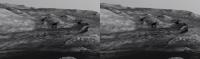
Posted by: atomoid Oct 12 2017, 08:45 PM
exhumed meteorite fragment or specular deception? m34/m100 cross anaglyph and detail in parellel view, but clearest view in the http://www.midnightplanets.com/web/MSL/image/01837/1837MR0096320000304875E01_DXXX.html original
Actually made me think of that 'italy' https://mars.jpl.nasa.gov/msl-raw-images/msss/00173/mcam/0173MR0926020000E1_DXXX.jpg way back at yellowknifehttp://www.unmannedspaceflight.com/index.php?s=&showtopic=7591&view=findpost&p=197528, which looking back was probably a meteorite fragment still embedded.
|
|
|
Posted by: Phil Stooke Oct 13 2017, 09:40 AM
A small move on sol 1843... but just a turn in place, I think. If it was intended, it may be to reach an interesting target with the arm. Otherwise it might be an aborted drive. No map update for this.
Phil
Posted by: RoverDriver Oct 14 2017, 12:32 AM
Phil
It was an aborted drive. Not sure about the details since I was out of the office today but saw the fault on my email update.
Paolo
Posted by: djellison Oct 16 2017, 04:10 PM
Here's a cheat for those following along at home. Every day there is a drive or robotic arm stuff planned, ECAM delivers a sequence called FHAZ00190
It's an off-nominal image - if something happens that causes a drive to abort early or an arm sequence to stop unexpectedly....then FHAZ00190 gets taken.
Such as https://mars.jpl.nasa.gov/msl/multimedia/raw/?rawid=FLB_560761808EDR_F0661332FHAZ00190M_&s=1839
If it's a drive - quite often - the rest of the post drive imaging will still occurs such as a normal end of drive FHAZ, RHAZ and series of NavCam sequences - which is why there's an FHAZ00337 taken shortly afterwards..
https://mars.jpl.nasa.gov/msl/multimedia/raw/?rawid=FLB_560761909EDR_F0661332FHAZ00337M_&s=1839
Posted by: jvandriel Oct 16 2017, 07:55 PM
The Navcam L view on Sol 1846.
Jan van Driel
|
Posted by: Phil Stooke Oct 17 2017, 04:19 PM
Thanks, Jan. Here is your panorama in circular form. Moving along the ridge a bit. A map update will follow shortly.
Phil
|
Posted by: charborob Oct 17 2017, 05:32 PM
The sol 1846 Lmastcam drive direction view:
https://flic.kr/p/ZtLqiq
And a view of the nearby rocks:
https://flic.kr/p/ZtLjkU
Posted by: PaulH51 Oct 20 2017, 12:34 AM
gravelly workspace on the ridge (L-MastCam raw in MS ICE)
|
Posted by: PaulH51 Oct 20 2017, 05:10 AM
Roughly assembled sol 1850 L-NavCam post-drive partial pan assembled in MS ICE, raw, no additional processing.
Take Curiosity away from the gravel patch, and onto a potential drill test site? (Feed-extended drilling)
|
Posted by: HSchirmer Oct 20 2017, 09:46 AM
|
|
Could be the mind wanting to see patterns, pareidolia, but there seem to be several linear or rippled features in those pebbles...
Wonder if CO2 frosts and dunes can churn martian soil the same way freeze thaw does on earth...
Posted by: atomoid Oct 20 2017, 09:13 PM
I've noticed those elsewhere too and wondered if i was just seeing things, but I think they are for real, and they do seem mostly parallel..
<disclaimer>my novice armchair pseudo-geologist perspective that hopefully more knowledgeable folks can clarify or shoot down for us</disclaimer> is that any frost heave structures this small would be overrun quickly by aeolian effects. I suspect that the tendency of the pebble bits to settle into somewhat linear features is purely deflationary, one guess is that as the surface deflates, remnant bits should tend to migrate downslope until they come to rest against other bits, and the tendency of the linear features to be parallel to each other probably reflects the prevailing wind direction (sand ripple building affecting the transport of the bits) or an effect of the original layer structure of the bedrock they eroded from.
on a different note, aside from the 'atmospheric dust' confounding any sense of landscape direction, this is pretty cool https://accessmars.withgoogle.com/
Posted by: PaulH51 Oct 21 2017, 05:07 AM
Rocky workspace on the ridge (1850 L-MastCam raw in MS ICE)
|
Posted by: PaulH51 Oct 21 2017, 08:22 AM
8 raw frames R-MastCam mosaic, looking south and acquired before the drive on sol 1850. No processing after stitching in MS ICE
|
|
Posted by: charborob Oct 21 2017, 03:21 PM
Sol 1850 post-drive Lmastcam:
https://flic.kr/p/Cx4etG
Posted by: jvandriel Oct 21 2017, 08:23 PM
The Navcam L view on Sol 1850.
Jan van Driel
|
Posted by: PaulH51 Oct 22 2017, 09:17 AM
Animation of the drill load test (with the drill feed extended) on sol 1848.
9 FLB HazCam frames used in this simple animated GIF assembled in PhotoScape.
The image time-stamps indicate ~12 minutes in elapsed time for the test.
https://i.imgur.com/ePVMVrZ.gif
Posted by: jvandriel Oct 22 2017, 12:12 PM
The last complete image is down and here is the view.
Sol 1848.
Jan van Driel
|
Posted by: neo56 Oct 23 2017, 08:48 PM
Panorama taken with MC100 on sol 1852, debayered on Gimp:
https://flic.kr/p/ZkhLqS
Full resolution: https://www.flickr.com/photos/thomasappere/37630620450/sizes/o/
Posted by: PaulH51 Oct 24 2017, 03:23 AM
Three new Photojournal entries with updates on the steps taken towards possible resumption of drilling:
https://photojournal.jpl.nasa.gov/catalog/PIA22061: Testing New Techniques for Mars Rover Rock-Drilling
https://photojournal.jpl.nasa.gov/catalog/PIA22062: New Rock-Drilling Method in 'Mars Yard' Test
https://photojournal.jpl.nasa.gov/catalog/PIA22063: Mars Rover Step Toward Possible Resumption of Drilling
Posted by: Phil Stooke Oct 26 2017, 04:23 PM
Since we are stuck for a bit, here are two of Jan's recent panoramas in circular form to show off the great scenery.
Phil
Sol 1848:
|
Sol 1850:
|
Posted by: Sean Oct 28 2017, 09:20 PM
Sol 1856 batch with extended sky & foreground fills...
Mastcam left Panorama East
https://flic.kr/p/ZQWFTh
Mastcam left Panorama North
https://flic.kr/p/ZTM9m8
Mastcam left Panorama North detail
https://flic.kr/p/ZR6gN5
Mastcam left Panorama West
https://flic.kr/p/ZTWdLH
Mastcam left Panorama West detail
https://flic.kr/p/ZRf1X5
Mastcam right...
https://flic.kr/p/FX6zjc
edit: uploaded the correct Mastcam right image
Posted by: erwan Oct 30 2017, 01:30 AM
Sean thank you for these beautiful pics
Posted by: neo56 Nov 1 2017, 09:02 PM
Mars in the morning, noon and evening as imaged by MC34 and MC100 on sol 1844:
https://www.flickr.com/photos/thomasappere/26320369199/sizes/o/
https://www.flickr.com/photos/thomasappere/26320727129/sizes/o/
|
|
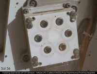
Posted by: PaulH51 Nov 3 2017, 11:14 AM
Very impressed with the recent posts on this thread, splendid work by all contributors...
Meanwhile.... Another in the ongoing checks of the dust on the REMS UV housing took place during sol 1863.
Here is a reduced montage of 25 selected checks since landing, sol numbers added with a rough description of the location. I've also provided a link to the latest MAHLI.

|

Posted by: PaulH51 Nov 3 2017, 10:29 PM
Partial L-NavCam pan after Curiosity's drive to the WSW during Sol 1864 (roughly assembled in MS ICE) http://www.midnightplanets.com/web/MSL/sol/01864.html
|
Posted by: jvandriel Nov 5 2017, 12:49 PM
The Navcam L view on Sol 1864.
Jan van Driel
|
Posted by: Phil Stooke Nov 6 2017, 04:39 PM
Jan's panorama in circular format:
|
Phil
Posted by: Sean Nov 6 2017, 07:15 PM
Mastcam left view from Sol 1866, extended sky, patched in Mt Sharp & foreground fills.
https://flic.kr/p/21bAXsJ
Posted by: jvandriel Nov 6 2017, 08:55 PM
The Navcam L view on Sol 1867.
Jan van Driel
|
|
Posted by: Phil Stooke Nov 7 2017, 12:58 AM
Thanks, Jan - here is a circular version. I can see I should have moved the map location for sol 1867 a bit further southeast.
Phil
|
Posted by: charborob Nov 7 2017, 02:12 PM
Sol 1866 Lmastcam:
https://flic.kr/p/GjEJvg
Posted by: Art Martin Nov 7 2017, 06:31 PM
What an amazing view of the path ahead. Does anyone know the height of some of those large mesas at the base of Mt. Sharp? So hard to get a feel of scale in these photos. I remember early in the mission the first high res shots of that area there was a boulder down at the base of one of them and it was supposedly taller than the rover and it looked tiny in comparison to the hill beside it.
Posted by: RoverDriver Nov 7 2017, 06:55 PM
This should give you a rough idea:
https://hirise-pds.lpl.arizona.edu/PDS/EXTRAS/DTM/PSP/ORB_009100_009199/PSP_009149_1750_PSP_009294_1750/DTEEC_009149_1750_009294_1750_U01.ca.jpg
Paolo
Posted by: Sean Nov 7 2017, 07:39 PM
If you have a Daydream or GearVR phone [ or phone supporting VR ] or HMD you can visit this area in person. The mesas are frickin' huge.
https://skfb.ly/68HnC
Posted by: jvandriel Nov 10 2017, 09:31 AM
The Navcam L view on Sol 1869.
Jan van Driel
|
|
Posted by: Floyd Nov 10 2017, 04:28 PM
The rim is so clear now--dust must be very low!
Posted by: Phil Stooke Nov 10 2017, 06:13 PM
Yes, it's great to see the rim again so clearly.
Here is Jan's panorama from sol 1869 in circular form. We are in a recess in this small topographic step on the ridge, probably ready to climb it now. Let's hope that drill can be used on the ridge before we have to move on.
Phil
|
Posted by: Floyd Nov 10 2017, 10:56 PM
Any chance this is a walk around to understand the overall diversity of rock types, and when done, possibly go back down the hill to an older layer to start drill sampling?
Posted by: Phil Stooke Nov 10 2017, 11:45 PM
I really can't see a return to the lower surface north of the ridge. That geologic unit had been drilled further north, and examined at almost every stop by ChemCam and APXS along the way.
Phil
Posted by: Floyd Nov 11 2017, 12:00 AM
I was thinking older and younger layers of Vera Rubin Ridge, not all the way back down.
Posted by: PaulH51 Nov 11 2017, 06:32 AM
Question for the group: I used to get the approximate elevation of Curiosity from the JPL traverse maps posted https://mars.jpl.nasa.gov/msl/mission/whereistherovernow/, but JPL have not updated the maps since sol 1830. I'm guessing I could obtain elevation from NAIF or maybe from the JSON files. Not sure how easy that would be, but likely beyond my skill-set. So I'm hoping there could be another source for that data without having to await the PDS....
In the meantime here's a (very rough & ready) Curiosity Sol 1871 L-NavCam partial pan assembled in MS ICE, the stitch is poor, but the scenery is lovely.
|
Posted by: jvandriel Nov 11 2017, 07:33 PM
The Navcam L view on Sol 1871.
Jan van Driel
|
Posted by: HSchirmer Nov 11 2017, 07:39 PM
That geologic unit had been drilled further north, and examined at almost every stop by ChemCam and APXS along the way.
Phil
But, if you don't drill actual bedrock, how would you know it's the same geologic unit?
Posted by: neo56 Nov 11 2017, 08:38 PM
I made an animation with the 25 MAHLI dust level checks of REMS UV sensors that Paul selected.
The distribution of dust changes between sols 1498 and 1552: while dust was evenly distributed on the ring-shaped magnets before sol 1498, it then forms accumulations, as if the fine fraction of dust had been blown away by a wind event. We also observe this dust accumulation on the left side of the REMS device.
|
https://www.flickr.com/photos/thomasappere/37561327234/sizes/o/.
Posted by: Phil Stooke Nov 11 2017, 09:25 PM
"But, if you don't drill actual bedrock, how would you know it's the same geologic unit?"
All the ChemCam and APXS data, plus geological interpretation of HiRISE and rover images. The rover updates at JPL have made clear the interpretation being followed by the rover team. This ridge is a new unit. To go back to the earlier question, which I misinterpreted, certainly there might be a return to lower units on the top of the ridge if variations in ChemCam and APXS (plus Mastcam multispectral) suggest it's useful, otherwise one drill site may be enough.
Anyhoo, here is Jan's 1871 panorama in circular form.
Phil
Posted by: PaulH51 Nov 12 2017, 11:31 AM
Curiosity's weekend workspace L-MastCam, raw in MS ICE. Also a rather nice cropped ChemCam RMI target that features in the workspace. sadly no target names (yet)
|
|
Posted by: Ant103 Nov 12 2017, 02:03 PM
Hi everyone
Found some motivation to do some work there. So, a little bunch of panoramic of my own
Sol 1866 Mastcam34
http://www.db-prods.net/marsroversimages/Curiosity/2017/Sol1866_Mastcam34.jpg
Sol 1867 Navcam
http://www.db-prods.net/marsroversimages/Curiosity/2017/Sol1867_pano.jpg
Sol 1869 Navcam
http://www.db-prods.net/marsroversimages/Curiosity/2017/Sol1869_pano.jpg
Sol 1871 Navcam
http://www.db-prods.net/marsroversimages/Curiosity/2017/Sol1871_pano.jpg
And an extra postcard, from Sol 1866, by Mastcam100 :
http://www.db-prods.net/blog/2017/11/08/mars-by-curiosity-a-sol-1856-postcard/
Enjoy
Posted by: climber Nov 12 2017, 05:13 PM
C'est la cas!
Merci Damia
Posted by: jvandriel Nov 12 2017, 10:31 PM
The Navcam L view on Sol 1873.
Jan van Driel
|
Posted by: PaulH51 Nov 12 2017, 10:34 PM
Possible aborted drive on 1873, very small move, nothing obvious in the workspace that would warrant a short bump, but what do I know
|
Posted by: Ant103 Nov 13 2017, 12:25 AM
Sol 1873 Navcam panoramic :
http://www.db-prods.net/marsroversimages/Curiosity/2017/Sol1873_pano.jpg
Posted by: HSchirmer Nov 13 2017, 01:32 AM
All the ChemCam and APXS data, plus geological interpretation of HiRISE and rover images.
...
Phil
Good point.
But, eh, I guess I should have phrased my question differently....
What if Vera Ruben Ridge was influenced by groundwater from a deep fault
https://www.lpi.usra.edu/meetings/lpsc2013/pdf/3106.pdf
would we be able to identify vertical displacement?
Lots of sedimentary basins on Earth have developed deep faults that create paths for groundwater flow-

Would there any way to determine whether the geological unit NORTH of the Vera Rubin Ridge has moved higher or lower
than the same geological unit SOUTH of Vera Rubin Ridge?
Posted by: Phil Stooke Nov 13 2017, 02:59 AM
So the first step would need to be detailed geological mapping using HiRISE images and the CRISM compositional data. Is there much evidence of faulting? Not sure, but it could be looked for. My impression is that there has not been a huge amount of faulting, so I would not be expecting an explanation based on large vertical motions. But I haven't done that work myself. Part of the reason for all the Mastcam imaging of the ridge along its northern side was to map the stratigraphy and structure. That can continue to the south as well. Wil there be evidence of vertical offsets? Or is it all stratigraphy, layer after layer without much faulting? I don't know, but that's how it could be tackled.
Phil
Posted by: HSchirmer Nov 13 2017, 03:35 AM
Phil
Well, reason I'm asking, what may be dumb questions.
Given the amount of boxwork exposed not that far away- at Naukluft plateau, and at the base of Mount Sharp

and given estimates that boxwork features are likely due to groundwater,
and given estimates that cubic kilometers of groundwater are needed to create the boxwork features
https://thesis.library.caltech.edu/9838/1/Siebach_Kirsten_Thesis_2016_chapters1-3.pdf
Then it might be interesting to look at layering, not just "It's sandstone" or "it's mudstone" but which lake layer are we talking about?
Idea being, that identification of specific lake layers, allows you to identify offset faults, and identify discontinuities.
Now, that's a HUGE challenge to put on somebody else, doing high resolution stratigraphapy takes huge amounts of data.
I'm just a bit curious whether the huge amounts of data being collected could eventually identify likely groundwater sources.-
"oh, there's a fault here, we see that the layers are offset by (1, 10, 100, 1000 meters) which suggests that there's a connection
to groundwater going down at least (1, 10, 100, 1000 meters)...
Posted by: RoverDriver Nov 13 2017, 02:58 PM
The drive was intentionally short. Some targets were out of reach and on the previous drive we did not want to overshoot. While our cameras are well calibrated one has to account for some measurement errors!
Paolo
Posted by: PaulH51 Nov 13 2017, 08:00 PM
Many thanks Paolo, also the weekend plan just got released and it mentioned the 'bump'
Posted by: charborob Nov 13 2017, 08:19 PM
Sol 1873 Lmastcam:
https://flic.kr/p/GyvhnP
Posted by: RoverDriver Nov 13 2017, 11:08 PM
One would think there's a uniform understanding of what constitutes as a "bump". I have seen a 20-30m drive referred to as a bump. I end up calling anything that is less than a meter a "burp" since that typically requires only one or two rover steps.
Paolo
Posted by: Gerald Nov 14 2017, 01:37 PM
https://en.wikipedia.org/wiki/Tafoni and https://en.wikipedia.org/wiki/Honeycomb_weathering as examples of salt weathering are other options, Given the sulfate-rich overlying layers, I'd consider some kind of salt weathering as another, if not more plausible, cause of the boxwork. This doesn't rule out additional groundwater activity, but it may be less evident, at least from a distance.
Posted by: serpens Nov 14 2017, 09:15 PM
The boxwork is on the horizon between the sulphate rich upper member of the Mount Sharp lower formation and the overlying aeolian deposits. There would almost certainly have been a hiatus following the final water influenced deposition so dessication fracturing must be a contender and given the lack of lithification of the overlying deposits any subsequent groundwater interaction must have occurred before the aeolian deposition.
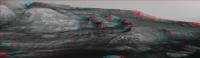
Posted by: atomoid Nov 15 2017, 12:04 AM
Tafoni-esque weathering due to differential cementation? nice example of a bedrock remnant here in stereo (anaglyph/cross/parellel) from http://www.midnightplanets.com/web/MSL/image/01870/1870MR0097720280105178C00_DXXX.html M34/m100 pair (debayered via G'MIC in GIMP).
|
|
|
Posted by: MarkG Nov 15 2017, 06:49 PM
Are the sediments Curiosity is among still nearly level on the average, or are they dipping towards the rim?
Posted by: PaulH51 Nov 16 2017, 10:11 AM
Sol 1876 RMI mosaic (MS ICE), possibly the dark-toned pebble dubbed "Middleton" referenced in the latest https://mars.jpl.nasa.gov/msl/mission/mars-rover-curiosity-mission-updates/?mu=sol-1875-1876-sitting-on-the-boundary
|
Posted by: PaulH51 Nov 17 2017, 02:18 AM
Curiosity completes another drive on sol 1877, https://mars.nasa.gov/msl/mission/mars-rover-curiosity-mission-updates/?mu=sol-1877-1878-the-last-drive-before-thanksgiving. We don't have the post drive images yet, but Midnight Planets is https://twitter.com/MidnightLoader/status/931327328327753728 it as ~20.2m Southwest (-143º)
Posted by: jvandriel Nov 17 2017, 11:02 PM
The Navcam L view on Sol 1877.
Jan van Driel
|
Posted by: PaulH51 Nov 18 2017, 08:02 AM
Nice NavCam Pan Jan
Here's the Arm Workspace for Sol 1877 L-Mastcam MS ICE / Raw
Really nice facets on the sections of exposed bedrock? I guess there is a proper name for that sort of erosional feature, but they look cool whatever they're called
|
Posted by: charborob Nov 18 2017, 06:29 PM
Sol 1877 Lmastcam view:
https://flic.kr/p/21zBupE
Posted by: Phil Stooke Nov 18 2017, 06:39 PM
On sol 1878 a set of images were taken by the Right Navcam looking at the mountain to search for changes (dust devils etc.) No dust devils are obvious in them but there is an interesting change.
There are 5 images in the set. Images 4 and 5 show a significant change, a band crossing the mountain:
|
In this image the top is the raw Navcam (5th image). The middle is a VERY extreme contrast stretch of the difference between 4 and 5, showing a white band. The white is not significant - it would be dark if I did the comparison the other way round, so it only serves to identify an area of change. The bottom overlays the difference on the raw image to show where the difference is.
Doing the same with images 3 and 4 gives this:
|
The white band has moved - in time order it moves from the top of the ridge down towards the rover. There are possibly other subtle changes in the middle distance. Images 1 and 2, and 2 and 3, also show extremely subtle changes which might be real.
The change might be on or near the surface - a puff of dust picked up by wind - or it might be caused by moving cloud shadows.
Phil
Posted by: Phil Stooke Nov 18 2017, 06:55 PM
And Jan's sol 1877 panorama in circular form. Interesting that the top of the ridge here has a gravelly surface, quite different from the bare fractured rock on the lower terraces. In HiRISE it looks very bland.
Phil
|
Posted by: fredk Nov 18 2017, 10:56 PM
I've noticed similar things before. Here's an example from 1787 (which I never posted back then) where you can clearly see dark/light bands moving up the slopes:

|
I agree broad gusts or cloud shadows are likely to blame.
Posted by: PaulH51 Nov 18 2017, 11:13 PM
Rough and ready stitch of a set of 10 sol 1979 RMI's that feature a distant target seen on this mast cam frame from charborob's 1877 mosaic.
The images are unprocessed except for stitching.
|
|
Posted by: PaulH51 Nov 18 2017, 11:14 PM
Well spotted guys
Posted by: Ant103 Nov 19 2017, 11:02 AM
Sol 1877 Navcam panorama. The softness of late afternoons landscapes
http://www.db-prods.net/marsroversimages/Curiosity/2017/Sol1877_pano.jpg
Posted by: PaulH51 Nov 19 2017, 11:47 AM
Interface of two rock types? or alteration zone (groundwater from the larger fracture?)
Raw Sol 1879 MAHLI (https://mars.jpl.nasa.gov/msl-raw-images/msss/01879/mhli/1879MH0002990010702448C00_DXXX.jpg) Many more fine examples of dark and light toned targets examined by the MAHLI http://www.midnightplanets.com/web/MSL/sol/01879.html
|
Posted by: neo56 Nov 20 2017, 07:56 AM
Mosaic of two debayered MC100 photos, showing nice details on the distant hills.
https://www.flickr.com/photos/thomasappere/38472252266/sizes/o/
Posted by: erwan Nov 21 2017, 12:53 AM
Superbe image merci !
Posted by: PaulH51 Nov 21 2017, 08:57 AM
Some rather nice L&R Mastcam images acquired just before sunset on http://www.midnightplanets.com/web/MSL/sol/01880.html The mission update refers to these as https://mars.jpl.nasa.gov/msl/mission/mars-rover-curiosity-mission-updates/?mu=sols-1879-1881-stay-frosty
Sadly they are Bayer encoded and jpeg'ed, so beyond the range of my rather basic skill-set. Hopefully someone can do them the justice they deserve and possible acquire another fine animated Martian sunset.
|
Posted by: PaulH51 Nov 23 2017, 12:58 AM
A small set of pre-dawn RMI's looking for https://mars.jpl.nasa.gov/msl/mission/mars-rover-curiosity-mission-updates/?mu=sols-1882-1888-stuffed-with-science on sol http://www.midnightplanets.com/web/MSL/sol/01883.html
One http://www.midnightplanets.com/web/MSL/image/01883/CR0_564628645PRC_F0670000CCAM01882L1.html in the set of four! Maybe some sort of over exposed or a calibration image? I have not encountered one like this before... Any ideas?
|
Posted by: fredk Nov 23 2017, 01:36 AM
Underexposed, by the look of it.
Here's a quick-and-dirty stab at deBayering that sunset pic:
|
I've done some heavy Gaussian blurring of the hue and saturation channels.
We can't trust the colours here, due to the heavy colour banding/quantization due to the jpegging of the Bayer. In particular I don't buy the grey outer sky regions. But, as always, it's worth it since the raw pds images will be stunning...
Posted by: vikingmars Nov 23 2017, 09:32 AM
Here's a quick-and-dirty stab at deBayering that sunset pic:
We can't trust the colours here, due to the heavy colour banding/quantization due to the jpegging of the Bayer. In particular I don't buy the grey outer sky regions. But, as always, it's worth it since the raw pds images will be stunning...
Dear Fredk, thanks a lot for saving us time for this debayering.
Here are the approximate (real) colors I found on your nice image, after using my database and a quick processing.
Enjoy
|
Posted by: PaulH51 Nov 26 2017, 01:02 AM
Ryan Anderson 'Advocated for ChemCam to use its RMI to take a closer look at an interesting geologic contact on Mt. Sharp during Sol 1885' in the current https://mars.jpl.nasa.gov/msl/mission/mars-rover-curiosity-mission-updates/?mu=sols-1882-1888-stuffed-with-science.
Here's my roughly assembled mosaic of the raw RMI's using MS ICE:
|
|
Posted by: Ant103 Nov 26 2017, 12:25 PM
My take on this picture
http://www.db-prods.net/marsroversimages/Curiosity/2017/1880ML0098480180703571C00_DB_web.JPG
Posted by: PaulH51 Nov 27 2017, 08:00 AM
1887 drive, no details yet, but here are the 3 available L-NavCams frames featuring the horizon assembled in MS-ICE, the distant rounded Mesa's and Buttes look really inviting
|
Posted by: avisolo Nov 27 2017, 10:17 AM
My take:)
Posted by: Ant103 Nov 27 2017, 12:09 PM
I played a little with tosol images. So I can make a little Postcard of this nice point of view
http://www.db-prods.net/blog/2017/11/27/la-terre-promise-sol-1887-postcard/
Posted by: Phil Stooke Nov 27 2017, 07:01 PM
Nice postcard! These are the reprojected Hazcam images I used to estimate our current position, about 10 m south of the Thanksgiving stop.
Phil
|
Posted by: Ant103 Nov 27 2017, 11:46 PM
Thanks
Maybe it can be handle to have the full panoramic now all the images are downlinked ^^
http://www.db-prods.net/marsroversimages/Curiosity/2017/Sol1887_pano.jpg
Posted by: Phil Stooke Nov 28 2017, 12:13 AM
I thought we had moved about 10 m south, but Midnight Planets says 26 m. I'll have to think about that... but Damia's full panorama will be useful. More to follow.
EDIT - sure enough, the full pan tells a different story. Here is a circular projection of that panorama (Thanks, Damia):
|
I was looking at the white drift to the southeast - I misidentified it on the HiRISE image. Map will be updated momentarily - no, actually, permanently!
Phil
Posted by: PaulH51 Nov 28 2017, 10:24 AM
Really stunning terrain captured in this telephoto RMI mosaic of a distant mesa on Mt sharp that Ryan Anderson at USGS/JPL has been monitoring for changes.
Sol 1888, roughly assembled in MS ICE, full size 5655x1704
Link to the http://www.midnightplanets.com/web/MSL/sol/01888.html
NASA/JPL-CalTech/MSSS/LANL
|
Posted by: Art Martin Nov 28 2017, 08:26 PM
Sol 1888, roughly assembled in MS ICE, full size 5655x1704
Link to the http://www.midnightplanets.com/web/MSL/sol/01888.html
NASA/JPL-CalTech/MSSS/LANL
|
|
Amazing photo. Oh the nuts are going to go crazy seeing that next to the last image from the right side of this pan with the strange rock that looks like a black shark fin. Can we say Curiosity has now officially jumped the shark? Laughing.
Posted by: PaulH51 Nov 29 2017, 07:06 AM
It's a pity they don't do the cloud and DD searches with the stereo paired cameras.
An 1888 R-NavCam sequence of 8 frames has a really nice cosmic ray strike or whatever else one would like to think it is
The version uploaded here is increased in size to 1000x1000 and a link provided to the raw image https://mars.jpl.nasa.gov/msl-raw-images/proj/msl/redops/ods/surface/sol/01888/opgs/edr/ncam/NRB_565099491EDR_M0670216NCAM00567M_.JPG
|
A stereo pair would have been nice to prove one way or another that it's unlikely to be an incoming space rock or a piece of space junk etc but a simple cosmic ray strike with a nice tail
Posted by: charborob Nov 29 2017, 11:49 AM
The sol 1887 Lmastcam view:
https://flic.kr/p/21WLi4W
Posted by: djellison Nov 29 2017, 07:08 PM
So - apart from doubling the data volume* for observations like this - there's another problem. The https://en.wikipedia.org/wiki/Resistance_thermometer used to monitor the Navcams is on the right camera.
Just under a year ago - we had an instance where we were taking dust devil and cloud movies, early in the morning, with the left camera - under the assumption that the heating being used that put the right camera into the allowable flight temperature range ( -55degC ) meant the left camera was in that safe range as well. On a few occasions due to lighting conditions, rover orientation etc...it wasn't. The left camera was used
The result is - we now have a thing called the no-heat-window - a period of time when it's OK to use both Navcams because the thermal team are confident that they'll be warm enough to be used anyway. Inside that window - we can do stereo. OUTside that window ( and it's typically around 1100 to 1800 at this time of year ) we're not allowed to use the left camera at all.
So - while ENV (environmental stuff - clouds, dust devils, etc etc) observations get done all over the place - the really nice early morning ones couldn't be done in stereo anyway because of this thermal constraint.
If you're wondering when this all happened - find the time when those observations swapped over from the left navcam to the right navcam ( shortly after Sol 1602 I think )
* There are some tricks one could maybe use in terms of issuing a data re-prioritization ...but that would be a BIIIGgg data management headache)
Posted by: elakdawalla Nov 29 2017, 09:53 PM
Gosh darn it this should be in my book and it's too late.
Posted by: Gerald Nov 29 2017, 11:15 PM
A possible impact site would be almost on a straight line defined by the intersection of the plane of the possible paths of a presumed meteorite with the martian surface. So it might be, that it would show up as one ore more darkish spots on a future HiRISE image, if it isn't too far away from Curiosity's location. At least something to check for.
Posted by: PaulH51 Nov 30 2017, 05:46 AM
Many thanks to Doug for the very valuable insight
Also Gerald for the suggestion to keep an eye on future HiRISE image around Gale for fresh impacts
Posted by: PaulH51 Nov 30 2017, 07:49 AM
Another long-distance telescopic survey with ChemCam, this time on sol 1890 featuring 'a fan like deposit closer to Mt. Sharp' (mentioned in this https://mars.jpl.nasa.gov/msl/mission/mars-rover-curiosity-mission-updates/?mu=sol-1889-1890-back-to-grind)
All ten frames were roughly assembled using MS ICE without additional processing.
Raw images https://mars.jpl.nasa.gov/msl/multimedia/raw/?s=1890&camera=CHEMCAM_
|
Posted by: Ant103 Nov 30 2017, 12:14 PM
Sol 1889 Navcam panoramic
http://www.db-prods.net/marsroversimages/Curiosity/2017/Sol1889_pano.jpg
Posted by: PaulH51 Nov 30 2017, 01:36 PM
Nice...
The inner rim wall looks much better with these lower levels of atmospheric dust Posted by: Phil Stooke Nov 30 2017, 06:48 PM
Damia's latest panorama in circular form. Thanks!
Phil
|
Posted by: charborob Nov 30 2017, 10:17 PM
The sol 1889 Lmastcam drive direction view:
https://flic.kr/p/21ZAFhW
Posted by: PaulH51 Dec 1 2017, 01:26 AM
The https://mars.jpl.nasa.gov/msl/mission/mars-rover-curiosity-mission-updates/?mu=sol-1891-making-do-with-what-you-got drive for sol 1891 towards the Southeast may take the rover close to the next map quadrant. Any guesses on the theme for the next quadrant?
Posted by: PaulH51 Dec 4 2017, 08:44 AM
Just 4 of the L-NavCams after the drive on Sol 1894, the rest of the images are down, but MS ICE did not want to play ball today. However, these may help to narrow down the location until someone can stitch the set together Nice to see the whole of the mountain without the need for a top tier, great pointing JPL Looking forward to seeing the full pan
|
Posted by: Ant103 Dec 4 2017, 12:25 PM
This panorama taken on Sol 1894 is just incredible. Like we could touch the hills !
http://www.db-prods.net/marsroversimages/Curiosity/2017/Sol1894_pano.jpg
Posted by: neo56 Dec 4 2017, 09:16 PM
Nice work Damia! What a wonderful sight Let's  to the hills!
Posted by: Phil Stooke Dec 5 2017, 12:23 AM
Yes, that is a beautiful view. Here is Damia's panorama in circular form. There are lots of circular depressions around here, presumably small impact craters.
Phil
|
Posted by: serpens Dec 5 2017, 08:03 AM
There doesn't seem to have been any progress on the drill since late October. Given that the hematite ridge is a reasonably important area for analysis can we assume that the non stabilised test on the drill function was unsuccessful?
Posted by: PaulH51 Dec 5 2017, 09:52 AM
Sol 1894 Workspace (raw L-MastCam assembled in MS ICE) contains several of the targets located above the shadow of Curiosity's mast that were mentioned in the https://mars.jpl.nasa.gov/msl/mission/mars-rover-curiosity-mission-updates/?mu=sols-1895-1896-dogleg-left
|
Posted by: PaulH51 Dec 5 2017, 11:04 AM
Measuring what remains of the Mount Sharp Ascent Route (MSAR) using Fernando's GE Map, there is a small loop that takes the rover a little way east before doubling back to the down ramp. From the current location the remaining path is just over one kilometer long, so unless they deviate from the plan and head straight for the down ramp we may still have plenty of time for JPL to work on the drill before dropping down onto the 'Clay' deposits that await beyond the ridge. (Fingers crossed)
See GE screen capture:
|
Posted by: Art Martin Dec 5 2017, 01:56 PM
I've been dying to see the latest views in 3D. Here's a quick and dirty one from 1894
https://flic.kr/p/216eCAQhttps://flic.kr/p/216eCAQ
Posted by: erwan Dec 5 2017, 09:42 PM
[quote name='Ant103' date='Dec 4 2017, 01:25 PM' post='237857']
This panorama taken on Sol 1894 is just incredible. Like we could touch the hills !
Magnifique encore Damia merci
Posted by: ngunn Dec 5 2017, 11:05 PM
We seem to be high enough now to see some mountains beyond the northern crater rim. They are at about 11:30 on that circular projection. Does anyone have a handy map of what's out there? Presumably we'll see more as we continue climbing, weather permitting.
Posted by: elakdawalla Dec 6 2017, 02:58 AM
Don't conclude that. It's just a very, very slow process. Drilling is only half the problem; delivering to the instruments is another equally difficult problem. In the meantime, they're driving when they can before AGU, Christmas, and New Year's.
Posted by: Phil Stooke Dec 6 2017, 03:21 AM
"We seem to be high enough now to see some mountains beyond the northern crater rim. They are at about 11:30 on that circular projection. Does anyone have a handy map of what's out there?"
http://www.unmannedspaceflight.com/index.php?showtopic=8309&st=165&p=236966&#entry236966
Phil
Posted by: PaulH51 Dec 6 2017, 09:28 AM
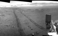
MS ICE made a pigs ear out of the 1896 NavCams, but the tracks came out well
|
Posted by: Ant103 Dec 6 2017, 12:33 PM
Thank you everyone for your kind messages
Here is Sol 1896 Navcam pan. Again, spectacular view there.
http://www.db-prods.net/marsroversimages/Curiosity/2017/Sol1896_pano.jpg
Posted by: Phil Stooke Dec 6 2017, 06:27 PM
Thanks, Damia - here is a circular version to show our location in the crater-like depression
Phil
|
Posted by: HSchirmer Dec 8 2017, 12:46 AM
|
|
Is the rover "crabbing" for some reason?
The left side tracks seem substantially wider than right side? Not just parallax,
but what seems to be considtent 1.5x or 2x tread width on the left, but 1.5x or 1.0x on the right?
Posted by: Gerald Dec 8 2017, 05:00 PM
On one track, the three wheels seem to be pretty well aligned, while on the other track they seem to be displaced by almost the width of a wheel, resulting in a wider track.
I could only speculate about the reason for the different horizontal displacements with respect to the driving direction. Might be some lateral slip due to the slope and sandy ground.
Posted by: elakdawalla Dec 8 2017, 07:54 PM
One way to do that would be if the track were not straight but actually had a constant curvature bent slightly to the rover's right. The middle wheels are positioned about half a wheel width outside the corner wheels. A slightly curved track would put the tracks from the wheels on the outside of the turn on top of each other, but would displace the track of the middle wheel on the inside of the turn off of the path of the corner wheels.
Posted by: Art Martin Dec 9 2017, 03:31 AM
Here's a 3D look at those tracks.
https://flic.kr/p/EaYpTQhttps://flic.kr/p/EaYpTQ
Posted by: RoverDriver Dec 9 2017, 03:05 PM
....
Bingo! Looking at the drive telemetry, the rover was curving to the right in order to keep heading for the waypoint we had set. There was no crabbing (difference between rover heading and rover yaw (*)) but a slight arc to the right. As you can clearly see on the NAVCAM mosaic, there's a slight cross-slope terrain we were driving over. Had the vehicle crabbed you would have seen the effects on the tracks with distorted cleat marks.
Paolo
(*)
heading=direction of motion of the vehicle
yaw=direction where the vehicle is pointed towards
Posted by: PaulH51 Dec 11 2017, 11:25 PM
1901, very roughly assembled in MS ICE, but should suffice until a better version is posted...
|
|
Posted by: Ant103 Dec 12 2017, 12:40 PM
Yes Paul, I'm here now 
This Sol 1901 Navcam panoramic :
http://www.db-prods.net/marsroversimages/Curiosity/2017/Sol1901_pano.jpg
Posted by: PaulH51 Dec 12 2017, 01:21 PM
Expertly crafted Damia, many thanks
MS ICE has its good days, but only rarely with NavCams.
I really enjoyed your version, not just for the quality of the blending and the stitching, but with this increase in elevation we are getting to see a little more the distant detail at the base the rim walls, such as slumping material and hints the alluvial fans that washed material into the crater. Imagine what those would look like in a MAHLI 'selfie' at the next drill site? (fingers crossed)
Posted by: Phil Stooke Dec 12 2017, 06:17 PM
A nice new panorama - thanks, Damia. Here is a circular projection of it. We are parked just north of a little step in the topography. (note that a rise near the rover is greatly magnified by the reprojection geometry here - I could re-do this with that taken into account but I don't usually bother)
Phil
|
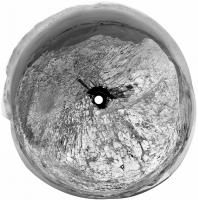
Posted by: serpens Dec 13 2017, 08:42 AM
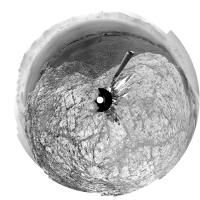
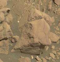
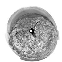
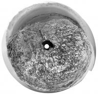
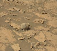
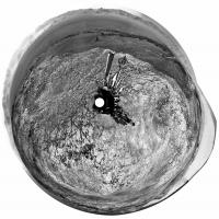
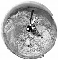
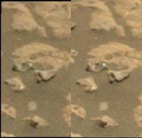
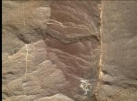
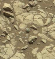
Sol 1901. Sphere, hemisphere, concretion or something else?
|
Posted by: Gerald Dec 13 2017, 03:06 PM
A spherical tektite?
Posted by: nprev Dec 14 2017, 05:29 AM
Looks very similar to some of the larger concretions at Meridiani.
Posted by: fredk Dec 14 2017, 03:43 PM
Navcam gives a diameter of around 5 or 6 mm. That is indeed at the large end of the Meridiani blueberry size distribution.
Posted by: serpens Dec 15 2017, 05:47 AM
It is a lonely little critter so regardless of provenance, transportation was probably involved.
Posted by: HSchirmer Dec 16 2017, 12:52 AM
Well, until the drill is working, guess ya drive over it, see if it breaks open...
Hmm, "note to self about next rover, include a nut-cracker mechanism to obtain cross sections..."
Posted by: RoverDriver Dec 16 2017, 01:28 AM
Hmm, "note to self about next rover, include a nut-cracker mechanism to obtain cross sections..."
Done that. She's called Opportunity. See rock "pork chop" and "jelly doughnut" around Sol 3400?
(Feb 4 2014).
Paolo
Posted by: PaulH51 Dec 16 2017, 04:00 AM
Drive on 1905: Roughly assembled L-NavCam pan in MS ICE, may help pin down the new location until a proper version can be assembled and posted. Some nice terrain just in front of the rover
|
|
Posted by: Phil Stooke Dec 16 2017, 07:45 AM
Thanks, Paul, it does help. Here's a circular version of it.
Phil
|
Posted by: Ant103 Dec 16 2017, 01:17 PM
Sol 1905 panoramic
http://www.db-prods.net/marsroversimages/Curiosity/2017/Sol1905_pano.jpg
Posted by: PaulH51 Dec 17 2017, 05:57 AM
Expertly crafted Damia
1906 RMI of an interesting little target. Not quite sure if ithe material on the left side is a thick mineral filled fracture, or another rock type, therefore an interface between two rocks. Leaning towards mineral filled fracture material
|
Posted by: PaulH51 Dec 17 2017, 11:44 AM
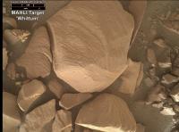
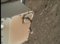
Unusually close to the sun dial in this MAHLI from 1904, much closer than the distance used for a Selfie, and focused on the ground. Hopefully the backdated weekend plan will be issued in a day or two will shed some light on what they were aiming to capture.
|
EDIT: They acquired another image with the sundial in focus, mystery solved?
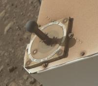
Posted by: mcaplinger Dec 17 2017, 02:51 PM
This is the best image of the cal target I've seen, and you can see the "MARS 2010" that we didn't update after the launch slip.
|
Posted by: Explorer1 Dec 18 2017, 01:29 AM
Cool! I suppose there's a good reason this sort of imaging hasn't been done until this far into the mission?
Posted by: Sean Dec 18 2017, 08:17 PM
Here is a partial glimpse of the epic panorama waiting in the wings.... MSL 1903 ML
https://flic.kr/p/HFY488
Posted by: neo56 Dec 18 2017, 09:40 PM
And my take on this awesome early morning panorama that is coming... Sol 1903, 8h07 local time.
https://www.flickr.com/photos/thomasappere/38432819554/sizes/o/
https://flic.kr/p/22CSAvM
Posted by: PaulH51 Dec 18 2017, 11:02 PM
1903 is going to be a outstanding 360. My previews all failed to pass internal QC, so I delighted to see these stunning teasers, plus I saw that Damia is working on de-bayering this set as well.
Further good news is that the team have ensured we can fill in the gaps on the 360 with a full suite of NavCam's of the deck. Hopefully the remaining images will make it to JPL soon, I'm really looking forward to seeing all the different versions
Keep up the excellent processing
Posted by: Julius Dec 19 2017, 12:56 PM
It might be premature to ask but any working hypothesis as to the origin of Rubin ridge?
Posted by: Ant103 Dec 19 2017, 01:04 PM
And, to complete the trio.
http://www.db-prods.net/marsroversimages/Curiosity/2017/Sol1903_Mastcam34_tmp.jpg
Posted by: Art Martin Dec 19 2017, 03:37 PM
In all those wonderful photos there's a ridge ahead with a rock layer on top and steep walls below it. I see no obvious places to climb over it in the wide section we are seeing. Is our path off to the left of what we're looking at with a gradual slope somewhere?
Posted by: Sean Dec 19 2017, 05:59 PM
Click thru for a video of the horizon area featured in the recent pano...
https://flic.kr/p/RscShW
https://www.youtube.com/watch?v=Rr3-WPhzoqI
More on the route ahead...
https://flic.kr/p/QcKTK1
Posted by: serpens Dec 19 2017, 09:55 PM
[quote name='Art Martin' date='Dec 19 2017, 03:37 PM' post='238015']
... there's a ridge ahead with a rock layer on top and steep walls below it. I see no obvious places to climb over it...
[/quote
That ridge is a remnant of what Anderson and Bell termed the "mound skirting unit" which was protected by fan material from the channel, now eroded back. If you watch Sean's impressive video titled Hematite and Clay, towards the end the rather benign area of the proposed path, towards at the rear left side of the fan is visible (around time stamp 1.45).
Posted by: Sean Dec 19 2017, 10:12 PM
I think I recall this is the area where Curi will ascend...just before the dunes on the left
Hopefully 'The Stooke' or Fernando will confirm or correct.
Posted by: serpens Dec 20 2017, 03:07 AM
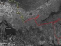
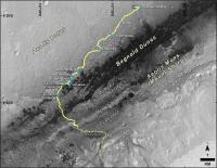
Around past the dunes I believe, unless they have significantly changed the basic route. Image from https://www.nasa.gov/image-feature/jpl/pia20846/curiosity-destinations-for-second-extended-mission
|
Posted by: fredk Dec 20 2017, 05:31 AM
This is a newer plan, but not very different:
https://photojournal.jpl.nasa.gov/catalog/PIA21720
Posted by: Sean Dec 20 2017, 10:42 AM
I was wrong. Here is the ascent area according to the post by Fredk...
Posted by: PaulH51 Dec 20 2017, 11:16 PM
1910, MS ICE L-NavCam (quick and dirty)
|
Posted by: atomoid Dec 21 2017, 02:00 AM
some stereo (cross-eye/anaglyph/parallel) of a couple frames ripped from Sean's absolutely remarkable rendered sequence. The path in the map that Fredk linked a few posts above would run up along the right bank of the channel as seen perhaps most distinctly in the parallel view at right, that sean pointed out a few posts above, though i was too lazy to attempt an oversketch of that route atop the frame.
|
|
|
Posted by: nogal Dec 21 2017, 04:33 PM
Here is a vertically exagerated view of the notional route Fred mentions. You can grab a KML file with it from http://www.unmannedspaceflight.com/index.php?showtopic=7442&view=findpost&p=236716
Fernando
|
Posted by: Sean Dec 22 2017, 09:07 PM
Here is a quick pass on a portion of the complete 360...
https://flic.kr/p/D7TdNi
Detail...
https://flic.kr/p/21qPB3D
Posted by: climber Dec 22 2017, 09:33 PM
Fernando
This is really helpful, thanks Fernardo
Posted by: PaulH51 Dec 23 2017, 01:42 AM
Lovely work Sean....
~5.4 meter drive SE (Midnight Planets) partial L-NavCam, also in the set was a couple of top tier frames featuring the extended drill, but MS ICE would not stitch them on to the others
|
Posted by: Ant103 Dec 23 2017, 11:29 AM
Sol 1912 Navcam panoramic.
http://www.db-prods.net/marsroversimages/Curiosity/2017/Sol1912_pano.jpg
Paul, seriously, trash your Microsoft Ice thing. Maybe it's efficient with common pictures, but Navcam pictures are not common. Use Hugin, or PTGui or something. It will be better 
Posted by: Sean Dec 23 2017, 12:21 PM
Another beautiful pano Damia. Do you straighten the horizon yourself? It always seems so 'locked in'. Looking forward to your debayered 1903 360...
Posted by: Gerald Dec 23 2017, 01:25 PM
Hugin finds correspondences itself. But with NavCam this usually doesn't work well. But you can add and remove these correspondences. By choosing such corresponding points near the horizon, you get a "locked" horizon.
Posted by: Sean Dec 23 2017, 01:51 PM
Thanks Gerald... I used Hugin a long time ago so I might give it another look.
Posted by: Ant103 Dec 23 2017, 02:12 PM
I'm doing it all manually. And all of my panoramas are made with manual settings, never automated process, with Navcam imagery.
And thanks you Sean I have a special project for this color panorama.
Posted by: charborob Dec 24 2017, 11:15 PM
Sol 1912 Lmastcam:
https://flic.kr/p/EGUbqQ
I don't understand why some mastcam images are debayered, and some are not.
Posted by: pdalek Dec 28 2017, 12:01 PM
Does anyone know why MARDI was taking so many images during Sol 1910?
Posted by: PaulH51 Dec 28 2017, 01:39 PM
From the 1909-1910 https://mars.jpl.nasa.gov/msl/mission/mars-rover-curiosity-mission-updates/?mu=sols-1909-1910-driving-home-for-the-holidays: During the drive (Sol 1910) we'll take a bunch of MARDI images to document the terrain beneath the rover.
I guess they will make a fine time lapse movie once properly processed
Posted by: nprev Dec 28 2017, 11:03 PM
And so https://www.flickr.com/photos/nev-t/38646816984
Posted by: nprev Jan 1 2018, 12:19 PM
Rather fascinating ChemCam image from sol 1921. Are these crystals, presumably (impure) gypsum or some sulfate? It almost looks like staurolite, but that would be a highly unexpected complex mineral. Hopefully there will be an analysis soon.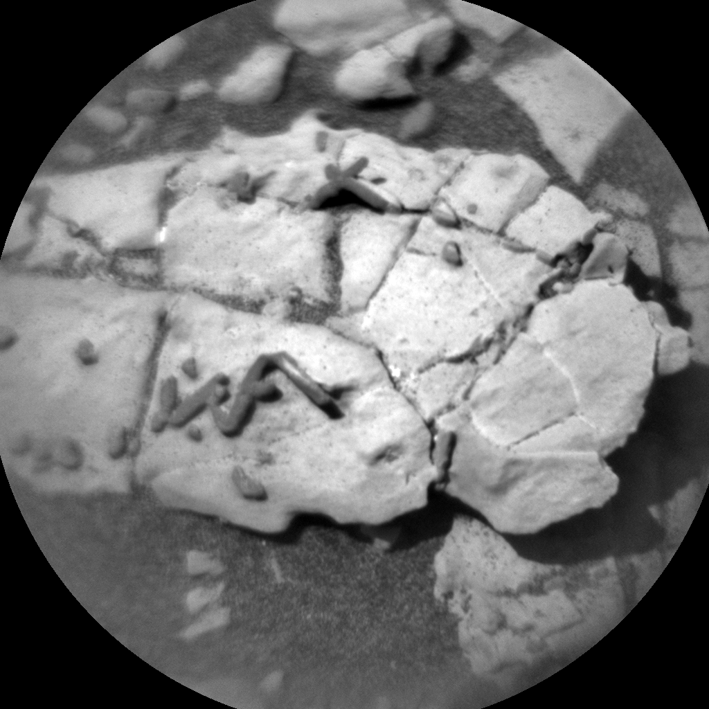
Posted by: PaulH51 Jan 2 2018, 07:14 AM
Here is the R-MastCam context image:

|
https://mars.jpl.nasa.gov/msl-raw-images/msss/01921/mcam/1921MR0100290000900414E01_DXXX.jpg to the full size version. Looks like there are even https://mars.jpl.nasa.gov/msl/multimedia/raw/?s=#/?slide=1922 of a set of MAHLI images of the same target
Posted by: serpens Jan 2 2018, 07:40 AM
There are a few more examples on the rock just to the left.

|
Posted by: PaulH51 Jan 2 2018, 01:20 PM
Maybe others? Here is an https://mars.jpl.nasa.gov/msl-raw-images/proj/msl/redops/ods/surface/sol/01922/soas/rdr/ccam/CR0_568116566PRC_F0671762CCAM06921L2.PNG that looks like it has captured what appears to a few more of these small 'crystalline structures'? Looking forward to seeing those MAHLI full frames...

|
Posted by: Gerald Jan 2 2018, 02:31 PM
With this context, I'm almost inclined to consider weathering remnants of an overlying layer as a possible origin, possibly some fracture fill.
In this case, I'm wondering, whether the geometry is pointing towards remnants of filled desiccation cracks. Could it be an iron-rich precipitate?
There are some (other?) presumed weathering remnants in https://mars.jpl.nasa.gov/msl-raw-images/msss/01921/mcam/1921MR0100290000900414E01_DXXX.jpg, which look darker and more saturated than the underlying layers. This might indicate towards a hematite, hence iron rich, and mostly weathered overlying layer.
Posted by: PaulH51 Jan 2 2018, 10:20 PM
The https://mars.jpl.nasa.gov/msl/multimedia/raw/?s=1922&camera=MAHLI are now available...
I have roughly assembled this red/cyan anaglyph from a pair of the images with approximately the same focus count. Others will be able to do a much better job, but evenin this rough version I can see the feature some has some depth, thus may fit with Gerald's observation re weathered remnants of an overlying layer.
|
Posted by: serpens Jan 2 2018, 10:25 PM
Fracture fill remnants feels right and they have the appearance of scattering rather than eroding out in situ. I wonder whether the two "host" rocks were once a single piece of float that fractured, separating along the plane of the fracture fill. Both "host" rocks seem to have areas of lighter colour which may, or may not be significant. One thing is certain, there are going to be some very interesting papers at the next LSPC.
Posted by: elakdawalla Jan 3 2018, 12:16 AM
I guess they will make a fine time lapse movie once properly processed
The term for this kind of observations is "sidewalk mode." From my book:
Posted by: mcaplinger Jan 3 2018, 01:53 AM
Another bit of trivia: this is the only part of the DEA software that was written after launch, and has only been used for the MARDI DEA. The other cameras are still running the same version of the software they were loaded with back in 2011.
Posted by: PaulH51 Jan 3 2018, 03:20 AM
1923 drive: here's a crop of what I could stitch with the L-NavCams, Damia or Jan will hopefully tackle the full pan, but this rough version may assist in narrowing down the location until they can post
EDIT Midnight Planets is having issues, but Joe's page has elements that are working again, his http://curiosityrover.com/tracking/drivelog.html suggest the drive was ~12m ~ESE

|
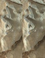
Posted by: serpens Jan 3 2018, 07:54 AM
They got really up close and personal with this image and the broken ends do look metallic. Some segments can be seen bonded to the rock and given that this area is the hematite ridge it seems likely that this is indeed iron oxide. It is almost as if Mars has its own version of banded iron formation based on fracture fill. On balance this seems more likely for oxygenated water infiltrating the saturated zone from a disconnected stream than groundwater flowing to the surface.

|
Posted by: Gerald Jan 3 2018, 06:12 PM
Hopefully, they'll be able to collect some APXS data, at least, in order to see whether it's actually some kind of iron mineral, or some SiO2 modification, instead. The latter could https://en.wikipedia.org/wiki/Conchoidal_fracture, and then appear specular, too.
Posted by: Art Martin Jan 3 2018, 10:53 PM
A quick and dirty stereo anaglyph of the Mount Sharp view on 1923
https://flic.kr/p/F2cPMbhttps://flic.kr/p/F2cPMb
Posted by: charborob Jan 4 2018, 12:42 AM
Sol 1922 Lmastcam:
https://flic.kr/p/F2nMmE
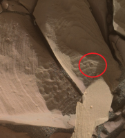
Posted by: PaulH51 Jan 4 2018, 02:30 AM
Facebook post from 'https://www.facebook.com/MarsCuriosity/photos/a.133197436730240.23875.110938085622842/1490868540963116/?type=3&theater' (January 4, 2018)
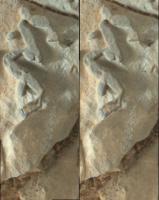
"Meanwhile, back on Mars... Im checking out these stick-like figures. Each is about a quarter-inch long. Maybe they're crystals? Or they could be minerals that filled spaces where crystals dissolved away. Stay tuned! Science continues."
Posted by: atomoid Jan 4 2018, 02:41 AM
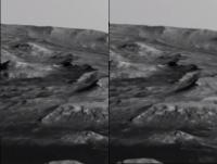
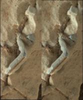
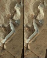
Noting a few apparent 'breaks' in the apparent layer remnant, did it get run over? its revealing brighter material inside almost as if its some sort of piping condensate. aside from that is an almost vertical line of 'etched' graininess to the right of the main leg and most visible in this http://www.midnightplanets.com/web/MSL/image/01922/1922MH0001760010703194C00_DXXX.html image, looking almost like an extended REMs strafing. heres cross/parellel stereo of the two main sections from a http://www.midnightplanets.com/web/MSL/image/01923/1923MH0007280000703205R00_DXXX.html pair.
|
|
|
|
Posted by: PaulH51 Jan 4 2018, 04:15 AM
My first thoughts were contact from the rover as we can see the sand around the target was https://mars.jpl.nasa.gov/msl-raw-images/msss/01922/mhli/1922MH0001900010703172C00_DXXX.jpg, but I dont know if the wheel ran over it during its travels http://www.unmannedspaceflight.com/index.php?act=attach&type=post&id=42436 or when it returned on http://www.unmannedspaceflight.com/index.php?act=attach&type=post&id=42436. It could also have been in contact with the APXS as they used it on this https://mars.jpl.nasa.gov/msl/mission/mars-rover-curiosity-mission-updates/?mu=sols-1913-1924-curiositys-working-holiday
Posted by: Phil Stooke Jan 4 2018, 07:20 AM
I never did post a circular version of the 1912 navcam panorama - this is from Damia's version.
Phil
|
Posted by: Ant103 Jan 4 2018, 12:48 PM
And the Sol 1923 complete panoramic
http://www.db-prods.net/marsroversimages/Curiosity/2018/Sol1923_pano.jpg
Posted by: PaulH51 Jan 4 2018, 01:13 PM
Damia to the rescue
Posted by: john_s Jan 4 2018, 08:29 PM
I have a request from my friend Nick Schneider, who's a coauthor of a popular astronomy textbook, https://www.amazon.com/s/?ie=UTF8&keywords=cosmic+perspective+8th+edition. He's looking for a publication-quality illustration for the latest edition of the book, that shows Curiosity's route of ascent of Mt Sharp (current and projected future) superposed on an oblique view of the terrain, ideally something like one of Sean's wonderful renderings, but with the route shown something like http://www.unmannedspaceflight.com/index.php?s=&showtopic=8333&view=findpost&p=238068. I suspect that an image focusing on the traverse from Bagnold Dunes onwards would be ideal.
I don't remember seeing an image exactly like that- could anyone point me to such an image if you know of it, or would anyone like to volunteer to generate one?
Thanks,
John
Posted by: scalbers Jan 4 2018, 10:08 PM
As a note, I can see the correlation now between the terrain in Sean's rendering in post #242 and Nogal's view in #245.
Posted by: elakdawalla Jan 5 2018, 12:26 AM
Has anybody taken a crack at DeBayering and assembling the sol 1911 MR panorama of the interesting "blue" outcrop? According to Abigail Fraeman in the sol 1911-1912 update:
Posted by: Sean Jan 5 2018, 12:56 AM
Here is a possible contender for the notional route map... this one is only good from mid Murray Buttes though
https://flic.kr/p/Ri6Hmf
http://gigapan.com/gigapans/195482
MSL Traverse Map v1 covers the whole route plus incorrect notional...
https://flic.kr/p/SdQrv1
http://gigapan.com/gigapans/196659
It might be possible to update with a new render depending on when it is needed.
Posted by: Sean Jan 5 2018, 02:15 AM
Sol 1911 MR
https://flic.kr/p/239BgRo
http://www.gigapan.com/gigapans/205369
I didn't futz around with the color too much, other than an exposure pass.
Posted by: elakdawalla Jan 5 2018, 06:20 AM
You really can see the color variation from red above to less red below though. Nice work, and thanks!
Posted by: elakdawalla Jan 5 2018, 06:23 AM
Holy cow, that's a lot of pixels! I can probably produce the map that John/Nick are looking for, but not until after I finish this wretched Curiosity update.
Posted by: PaulH51 Jan 6 2018, 03:36 AM
A small mosaic of one of the Sol 1925 https://mars.jpl.nasa.gov/msl/multimedia/raw/?s=1925&camera=MAHLI. MS-ICE, colours unprocessed.
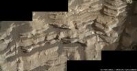
|
Posted by: Gerald Jan 6 2018, 08:37 PM
This https://mars.jpl.nasa.gov/msl-raw-images/msss/01925/mhli/1925MH0002910010703326C00_DXXX.jpg seems to open an option for http://eos.tufts.edu/varves/Geology/chronology.asp.
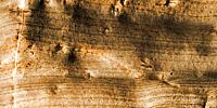
|
---
[@PaulH51: http://www.unmannedspaceflight.com/index.php?showtopic=7613&st=195&start=195 might be the better-suited one for posts regarding Analyst's notebook.] Good call, and PaulH51's post has been moved. -Mod.
Posted by: serpens Jan 7 2018, 01:28 AM
The thing I find intriguing is that there does not seem to be any indication of a freeze - thaw cycle.
Posted by: PaulH51 Jan 7 2018, 11:07 PM
Looks like the outstanding images for the L-MastCam 1903 pan are finally down. Looking forward to see what the image wizards can do with them
Posted by: PaulH51 Jan 8 2018, 02:04 PM
I seem to recall Phil predicting some interesting terrain on the other side of the ridge based on the satellite images. Looking at this roughly assembled 1928 partial L-NavCam pan I'd have to say 'Good call Phil'
It's got the usual stitching errors for MS ICE, but it may help get a rough fix of drive direction etc until the remainder of the images come down and they can be properly assembled. Feel free to delete once the proper version gets posted.
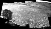
|
Posted by: PaulH51 Jan 8 2018, 02:51 PM
Thoughts on this little target?
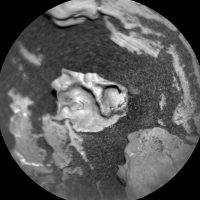
|
https://mars.jpl.nasa.gov/msl-raw-images/proj/msl/redops/ods/surface/sol/01928/soas/rdr/ccam/CR0_568653791PRC_F0671846CCAM05927L1.PNG
Posted by: vikingmars Jan 8 2018, 03:16 PM
How nice ! Thanks a lot Ant103 for this nice work of yours
Posted by: vikingmars Jan 8 2018, 03:30 PM
When I saw the pictures taken by the Curiosity rover on Sol 1903 which came online last week, I told myself "WOW !", because they reminded me the early morning view taken by the Viking 1 lander in 1976, the famous one with the backlit dunes...
Although the Curiosity pictures were shot in colour and are distributed in panchromatic 'raw' format, I think that the most artistic view is to leave them in black and white, because processing them to colour would erase some of the exquisite details inside a quasi-uniform yellowish-brown.
So, I decided to process the pictures as if they were taken in a panchromatic format.
Here is the resulting panorama from Curiosity, a truly spectacular one that is presented alongside the Viking lander historic view !
Enjoy it ...and also as a tribute to the Curiosity/MSSS team and the past Viking Lander Imaging Team
|
|
(P.S. : Please, note that the distortions inside the Viking and Curiosity views are not fully corrected : the horizon was not straightened)
Posted by: neo56 Jan 8 2018, 08:50 PM
Nicely done Olivier! It really puts into perspective the dramatic landscape in which Curiosity is roving
Posted by: charborob Jan 9 2018, 06:26 PM
Sol 1928 Lmastcam:
https://flic.kr/p/23kfks6
Posted by: vikingmars Jan 9 2018, 06:52 PM
Thanks a lot Neo56 for your kind comments
Posted by: PaulH51 Jan 10 2018, 09:14 AM
Well it sure looks like they made it to the 'Pay Dirt' at https://mars.jpl.nasa.gov/msl/mission/mars-rover-curiosity-mission-updates/?mu=sol-1929-30-aiming-for-pay-dirt
Partial L-NavCam pan on sol 1930, shows lots of potential targets in workspace....
|
Posted by: Ant103 Jan 11 2018, 11:35 AM
Thanks Olivier
Sol 1930 complete navcam pan. There is a gigantic gap behind Vera Rubin ridge, some deep valley.
http://www.db-prods.net/marsroversimages/Curiosity/2018/Sol1930_pano.jpg
Posted by: Gerald Jan 11 2018, 02:01 PM
The preliminary name of this valley seems to be https://www.hou.usra.edu/meetings/lpsc2016/pdf/2224.pdf (PT), and the contact between Vera Rubin Ridge and PT seems to be of particular interest, in order to help select the most likely formation option for Vera Rubin Ridge.
Posted by: Sean Jan 11 2018, 04:28 PM
There is a nice view of the area ahead about 1 minute into this video when we clear the ridge...
https://flic.kr/p/QcKTK1
Posted by: Phil Stooke Jan 11 2018, 04:52 PM
Damia's latest panorama in circular form.
Phil
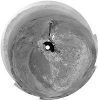
|
Powered by Invision Power Board (http://www.invisionboard.com)
© Invision Power Services (http://www.invisionpower.com)