Printable Version of Topic
Click here to view this topic in its original format
Unmanned Spaceflight.com _ MSL _ Journey to Mt Sharp - Part 3A: In-situ science at the Kimberley
Posted by: elakdawalla Apr 11 2014, 01:34 PM
As Curiosity has completed walking the Kimberley outcrop and the science team has http://astrogeology.usgs.gov/news/astrogeology/sol-596-update-on-curiosity-from-usgs-scientist-ken-herkenhoff-approaching-an-outcrop that could lead to our first drilled sample since Yellowknife Bay a year ago, I thought it was time to split to a new thread. http://www.unmannedspaceflight.com/index.php?showtopic=7747, which includes numerous Mastcam panoramas of the initial survey of the Kimberley that will probably take many weeks to downlink completely; I figure splitting it here will help us keep the active mission separate from the lagging arrival of data from that survey.
A few links for housekeeping purposes:
http://www.unmannedspaceflight.com/index.php?showtopic=7747&view=findpost&p=208228 - http://www.unmannedspaceflight.com/index.php?showtopic=7442&view=findpost&p=208227
http://www.unmannedspaceflight.com/index.php?showtopic=7747&view=findpost&p=208657 - http://www.unmannedspaceflight.com/index.php?showtopic=7442&view=findpost&p=208658
Posted by: Dig Apr 11 2014, 04:54 PM
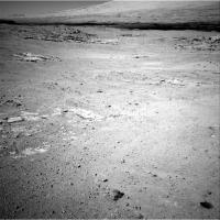
Navcams Left/Right Sol 597
https://flic.kr/p/mZSeM1
https://flic.kr/p/mZQwyv
Click on image for full resolution
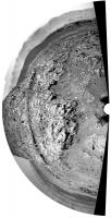
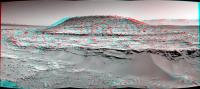
Posted by: Phil Stooke Apr 11 2014, 06:15 PM
Very nice - here's a circular version.
Phil
|
Posted by: anticitizen2 Apr 11 2014, 07:07 PM
http://i.imgur.com/ISYM8GM.gif - I like the side view of the small rock ridge
http://i.imgur.com/Kw3EuNW.gif
http://i.imgur.com/Kw3EuNW.gif
Posted by: Ant103 Apr 11 2014, 08:25 PM
Sol 597 Navcam pans. Impossible to put them together, a little move between them.
http://www.db-prods.net/marsroversimages/Curiosity/2014/Sol597_pano.jpg
http://www.db-prods.net/marsroversimages/Curiosity/2014/Sol597_pano2.jpg
Posted by: serpens Apr 12 2014, 12:47 AM
To the best of my knowledge I have not seen this Chemcam site linked. It provides some tyro friendly and up to date information on findings which could be enlightening as they get stuck into the Kimberley sandstones.
http://www.msl-chemcam.com/index.php
ADMIN EDIT: Link amended.
This and other useful links can be found in the http://www.unmannedspaceflight.com/index.php?showtopic=7375
If anyone has others, please let an admin know and we can add it.
Posted by: jvandriel Apr 12 2014, 12:49 PM
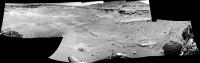
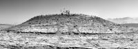
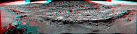
Mt Remarkable in Stereo on Sol 597.
Jan van Driel
|
Posted by: charborob Apr 12 2014, 08:42 PM
Sol 597 mastcam 34 pan:
|
Posted by: Phil Stooke Apr 12 2014, 09:32 PM
With a bit of fuddle-duddling it's possible to fit Damia's two pans together after reprojection, to create a reasonable facsimile of a full circular pan of the place.
Phil
|
Posted by: PaulH51 Apr 15 2014, 12:32 PM
The latest report from Ken Herkenhoff's was posted today at the USGS news portal http://astrogeology.usgs.gov/news/astrogeology/sol-598-600-update-on-curiosity-from-usgs-scientist-ken-herkenhoff-preconditioning. It address his role in planning and the activities for sols 598 thru 600... The activities ended with a short drive to a new location for further contact science this week. We have been receiving a steady supply of backlog images in recent sols, but nothing from 598 thru 600. Maybe another incident similar to 'the set of commands sent to the rover for Sol 596 were not received' http://astrogeology.usgs.gov/news/astrogeology/sol-597-update-on-curiosity-from-usgs-scientist-ken-herkenhoff-runout-sequence?
Posted by: Phil Stooke Apr 15 2014, 11:52 PM
Looks like the DRT was used on sol 601 (or at least the picture was taken on 601)
EDIT - Wrong! That is dust blasted away by ChemCam. I've made the same mistake before, about sol 485ish.
http://www.midnightplanets.com/web/MSL/image/00601/0601MH0001900010203206C00_DXXX.html
Phil
Posted by: jmknapp Apr 16 2014, 02:26 AM
The rock they brushed in ML image sol 597:
|
It's above the TY in Curiosity.
Posted by: cswift Apr 16 2014, 09:48 AM
These and other images from Sol 585 show a blurry gray area with a clearly defined border between layers of the outcrop imaged at the north of the Kimberley.
Not the lens flare on the left, it's visible at the back of the crevice starting at the far right where light is visible from the other side.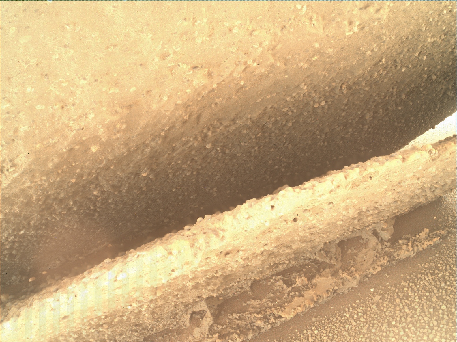
From above, the same blurry feature is partially visible at the edge of the upper face of the outcrop.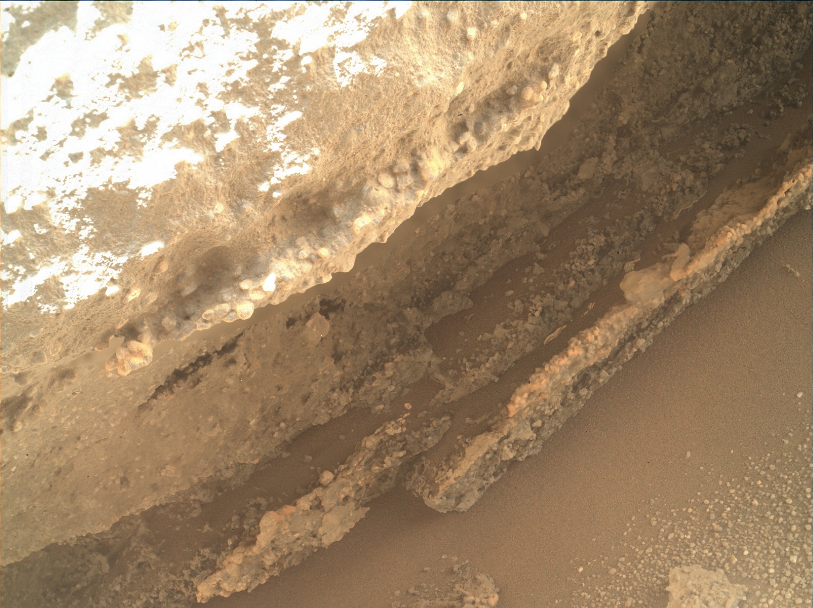
The effect looks strange to me and I haven't seen examples of this phenomena on any of the rover missions. I'd be interested to hear if others had more information or plausible ideas about this.
Posted by: wildespace Apr 16 2014, 09:58 AM
The "before" and "after" images from Mastcam Left (Sol 597) and MAHLI (Sol 601) of the dust removal activity.
|
(These are raw images, and it's interesting to note the colour difference between ML and MAHLI.)
Posted by: mcaplinger Apr 16 2014, 01:25 PM

I don't actually see what you're talking about, but these are focus-merged products and any poor focus areas are probably either from inadequate range in the original Z-stack or from glitches in the focus-merging algorithm.
Posted by: Gerald Apr 16 2014, 01:28 PM
That's a focus-stacked image, composed of portions of several images.
The focus stacking algorithm probably didn't find a sharp version of the blurry region.
The algorithm needs a subframe of some size to determine the best focus distance. The jump of the radial distance of the imaged rock within a small region, together with bright feature-rich foreground and dark feature-poor background, may have tricked the algorithm.
The single images usually are only available as thumbnails, e.g. http://mars.jpl.nasa.gov/msl-raw-images/msss/00584/mhli/0584MH0003620020202132I01_DXXX.jpg and http://mars.jpl.nasa.gov/msl-raw-images/msss/00584/mhli/0584MH0003620020202125I01_DXXX.jpg.
Edit: This image combines the distance map (green channel) and the brightness of the original image (as red and blue channel) :
|
The small mismatch gets visible.
(I don't think, that there is a way to fix this with a reasonable effort.)
Posted by: neo56 Apr 16 2014, 08:10 PM
Panorama of Mount Remarkable and surroundings taken on sols 597 & 601 with MC34:
https://www.flickr.com/photos/105035663@N07/13901497693/
Posted by: neo56 Apr 16 2014, 08:47 PM
https://hirise.lpl.arizona.edu/releases/msl-kimberley.php 
Posted by: neo56 Apr 17 2014, 05:59 PM
Mount Remarkable from the surface and from space! North is right on HiRISE picture.
https://www.flickr.com/photos/105035663@N07/13890405061/
Posted by: algorithm Apr 17 2014, 09:08 PM
Nice one Neo56,
The ultimate context camera!
This really helps to visualise the rover position in my head, thanks.
Why does the mound in the HiRISE image appear to be overhanging (dark shadows), yet appears to be a smoothish slope in the MC image, I know there are probably different lighting scenarios but ....
Does the shape of the shadow reflect the profile of the mound?
Posted by: algorithm Apr 17 2014, 09:27 PM
I was reading something today regarding fossilised raindrops and this part of a sol601 image seemed to fit the bill.
From what I read the theory seemed a bit 'iffy' (technical term!)
What do the auspiscious members think?
Posted by: serpens Apr 17 2014, 10:58 PM
I'm not sure that auspicious is the word you were looking for? Most probably gas escape as we have seen before but it would be helpful if you could identify the context image to confirm the scale.
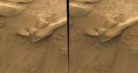
Posted by: atomoid Apr 17 2014, 11:08 PM
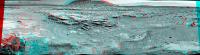
sol603 experimental crosseye (at left) using http://www.midnightplanets.com/web/MSL/image/00603/NRB_451027086EDR_F0311094NCAM00354M_.html as stand-in for the R image since the normal pair http://www.midnightplanets.com/web/MSL/image/00603/NRB_451027126EDR_F0311094NCAM00354M_.html underexposure had to be contrast-matched (xeye at right). The swap-out on the left xeye below actually produced a better result imho.. but since this matches R to L as the panhead pivots L>R instead of L to R with static panhead, im not sure if the resultant interpupillary distance in this scenario is wider or tighter..
|
|
Posted by: Gerald Apr 17 2014, 11:32 PM
...
http://mars.jpl.nasa.gov/msl-raw-images/msss/00601/mcam/0601MR0025370330400799E01_DXXX.jpg are similar features visible. Since the features aren't exclusively parallel to the the suspected sedimentary layers, I'd think fossilized traces of raindrops are very unlikely.
Interesting features, nevertheless!
Edit: http://en.wikipedia.org/wiki/Panhole show some remote similarity. But the surface is probably too inclined for some of the features to allow them being panholes.
Edit: http://commons.wikimedia.org/wiki/File:Salt_weathering_in_gozo.jpg can occur on inclined surfaces.
That's one of the options I couldn't rule out easily.
Posted by: atomoid Apr 18 2014, 01:31 AM
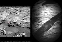
interesting red splotch on isolated rock in http://www.midnightplanets.com/web/MSL/image/00602/0602MR0025400210400859E01_DXXX.html M-100. just a dust-blasted face?
crosseye paired with its http://www.midnightplanets.com/web/MSL/image/00602/0602ML0025400210301309E01_DXXX.html to show the rock 'arm' which seem to be ubiquitous in this area.
|
Posted by: jmknapp Apr 18 2014, 02:29 AM
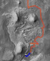
I was looking at the HiRISE DTM for the area & it looks like the peak of Mt. Remarkable is about 6 meters above the current rover position--is that right? Here's a map with 1m contours:
|
0.25m contours:
|
Posted by: Phil Stooke Apr 18 2014, 02:43 AM
Wow, that's really nice - I just had to overlay it on my route map:
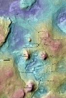
|
(and just in time! - jmknapp changed the map while I was busy overlaying it...) (oops - then he added it again - I can hardly keep up!)
Phil
Posted by: jvandriel Apr 18 2014, 08:46 AM
The Navcam NL B view on Sol 603.
Jan van Driel
|
Posted by: jvandriel Apr 18 2014, 09:12 AM
and the Stereo one from Sol 603.
Jan van Driel
|
Posted by: jmknapp Apr 18 2014, 10:03 AM
Sorry--messing with the software & realized the contour spacing wasn't right at first. Nice overlay!
Posted by: xflare Apr 18 2014, 10:10 AM
What do the auspiscious members think?
Can you link to the original image please?
Posted by: jvandriel Apr 18 2014, 12:31 PM
The Navcam NL B panoramic view on Sol 603.
Jan van Driel
|
Posted by: Phil Stooke Apr 18 2014, 02:43 PM
Thanks, Jan, very nice. Here is a circular version. So this is the backup drill area according to Ken's blog, and the prime drill area is about 30 m further south or SW. Any names floating around?
Phil
|
Posted by: neo56 Apr 18 2014, 08:17 PM
Mosaic of MC100 pictures of Mount Remarkable. Rocks have very different shapes and textures.
https://www.flickr.com/photos/105035663@N07/13927608234/
Posted by: algorithm Apr 18 2014, 08:41 PM
http://mars.jpl.nasa.gov/msl-raw-images/msss/00601/mcam/0601MR0025370590400825E02_DXXX.jpg
Posted by: anticitizen2 Apr 18 2014, 09:42 PM
http://i.imgur.com/US03vhb.gif - there are a bunch of segments, and it lasts just over a minute at 1 sec/frame
http://gfycat.com/MisguidedGargantuanLamprey - right click to show controls
http://i.imgur.com/GbI6jTg.gif
Edit: Responding to Joe's post below - wow, I was way off in my head, thanks for that!
Posted by: jmknapp Apr 19 2014, 01:35 AM
Some scale:
|
Posted by: jvandriel Apr 19 2014, 02:19 PM
The complete Navcam L B view on Sol 603.
Jan van Driel
|
|
Posted by: jvandriel Apr 19 2014, 03:13 PM
The Mastcam L view on Sol 603.
Jan van Driel
|
Posted by: Ant103 Apr 19 2014, 06:15 PM
Same panorama, bigger resolution here
http://www.db-prods.net/marsroversimages/curiosity-2014.html#78
Posted by: neo56 Apr 19 2014, 08:31 PM
Mosaic of MC100 pictures of Mount remarkable updated with pictures taken on sol 603:
https://www.flickr.com/photos/105035663@N07/13927608234/
http://www.gigapan.com/gigapans/153495
And my take on the MC34 panorama of sol 603:
https://www.flickr.com/photos/105035663@N07/13940401244/
Posted by: James Sorenson Apr 20 2014, 05:22 AM
From the look of the Sol-605 Thumbnails of the APXS placement onto soil, looks like some soil may have been removed and possibly stuck to the contact plate. Hopefully this wasn't the case and further imaging is done. The thumbs bring back memory's of the Sol-258 incident on Spirit of when the Mossbauer Spectrometer was placed onto soil, soil stuck to the contact plate, and was inadvertently placed onto the capture magnets and it got stuck there.
Posted by: jvandriel Apr 20 2014, 07:58 AM
Part of the left navcam panorama taken on Sol 603.
Jan van Driel
|
|
Posted by: wildespace Apr 20 2014, 10:17 AM
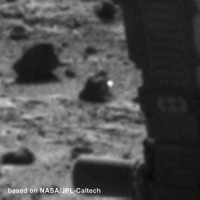
More mysterious lights, Sol 603 Navcam Right.
|
Curiosity has been seeing quite a few of them lately.
Sol 589:
|
Sol 568:
|
All cosmic ray strikes?
ADMIN: Inline images replaced with thumbnails. All please note http://www.unmannedspaceflight.com/index.php?act=boardrules
Posted by: nprev Apr 20 2014, 01:23 PM
Yes, almost certainly all CR strikes or hot pixels via other mechanisms.
Do yourself a favor & please don't start pointing each & every one of these out. They've been happening since not only MSL but on every imager we've ever sent beyond the Earth's Van Allen Belts.
Posted by: Ant103 Apr 20 2014, 02:52 PM
Oh please, not again
These are cosmic rays. So, can we move on please ?
Meanwhile, I had to make a Postcard version of my last panoramic
http://www.db-prods.net/blog/2014/04/20/carte-postale-mount-remarkable-sol-603/
Posted by: James Sorenson Apr 20 2014, 07:08 PM
Some soil has indeed stuck to the contact plate of APXS.
http://mars.jpl.nasa.gov/msl-raw-images/proj/msl/redops/ods/surface/sol/00605/opgs/edr/ncam/NRB_451209309EDR_F0311094NCAM00207M_.JPG
Posted by: fredk Apr 21 2014, 01:53 AM
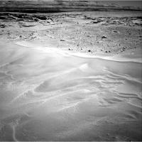
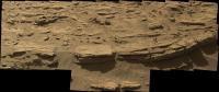
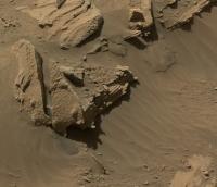
I'm crazy about these ultra-fine lattice-work details - the result of ages of wind erosion. It looks like the lightest touch would snap it off:
http://mars.jpl.nasa.gov/msl-raw-images/msss/00601/mcam/0601MR0025370520400818E01_DXXX.jpg
And... Oh yeah, that's where I left my Eiffel tower souvenir:
http://mars.jpl.nasa.gov/msl-raw-images/msss/00604/mcam/0604MR0025500110400907E01_DXXX.jpg

Posted by: walfy Apr 21 2014, 02:32 AM
Those are beauties! There's been a lot of wonderfully whimsical wind-worn rocks of late!
Posted by: eoincampbell Apr 21 2014, 02:39 AM
I would love to taste these Martian papadams...
Posted by: djellison Apr 21 2014, 04:59 AM
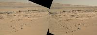
As @Matt_Heverly pointed out - lovely panorama on Sol 606.
(full size here - http://dougellison.smugmug.com/Landscapes/Curiosity/i-TSCH3Gp/0/O/NRB_451296171EDR_F0311256NCAM00495M_-Panorama-crop.jpg )
|
Posted by: Ant103 Apr 21 2014, 09:56 AM
And my take of the Sol 606 Navcam pan :
http://www.db-prods.net/marsroversimages/Curiosity/2014/Sol606_pano.jpg
Posted by: jmknapp Apr 21 2014, 10:13 AM
A little Easter Sunday drive--so is this the spot?
|
Posted by: jvandriel Apr 21 2014, 11:01 AM
Sol 606 Navcam view in Stereo.
Jan van Driel
|
Posted by: Phil Stooke Apr 21 2014, 02:57 PM
Yes, Joe, that's the spot. Map update from me when I can get to it.
Phil
Posted by: Nirgal Apr 21 2014, 03:28 PM
Jan van Driel
I would just like to say thank you Jan, for your prompt and technically well done 3D navcam anaglyph panoramas !
Especially for this one, which is one of the most scenic and dramatic stereo views I've ever seen from any surface mission on mars ....
Posted by: jvandriel Apr 21 2014, 05:46 PM
Thanks Nirgal
and here a view of the wheeltracks on Sol 606.
Jan van Driel
|
Posted by: jmknapp Apr 21 2014, 06:32 PM
I'm wondering if this is the spot where they will "do some science" (modulo a small bump here or there) or continue reconnoitering.
Posted by: Phil Stooke Apr 21 2014, 06:44 PM
The various contact areas here seem to be masked by drifts in many places - it doesn't look as promising to me as it did in HiRISE images. I hope a good spot will turn up.
Phil
Posted by: Art Martin Apr 21 2014, 08:43 PM
Phil
Oh to have a decent whisk broom on board.
Posted by: PaulH51 Apr 22 2014, 02:26 AM
Still 'reconnoitering' acording to Ken's latest report http://astrogeology.usgs.gov/news/astrogeology/sol-605-607-update-on-curiosity-from-usgs-scientist-ken-herkenhoff-windblown-soil
Posted by: anticitizen2 Apr 22 2014, 03:38 AM
Excited to have a Haz sequence to play with - I'm hoping to do a little stabilization tomorrow morning
But here is the AutoNav on 606
http://i.imgur.com/2btR6an.gif
http://i.imgur.com/prwZWil.gif and loop-reversed it for continuity
Posted by: jvandriel Apr 22 2014, 10:16 AM
Here is the complete Navcam NL B panoramic view taken on Sol 606.
Jan van Driel
|
|
Posted by: Ant103 Apr 22 2014, 10:23 AM
It's now complete
http://www.db-prods.net/marsroversimages/Curiosity/2014/Sol606_pano.jpg
Posted by: xflare Apr 22 2014, 11:35 AM
Jan van Driel
Great Work.
Posted by: anticitizen2 Apr 22 2014, 03:10 PM
I felt there was too much bouncing around in the Haz sequence to just post the 5 frame gif
http://i.imgur.com/9fEJhB0.gif
http://i.imgur.com/eJTbmAZ.gif Not as nice, but it gives an idea of whats to our left, now.
And a quick question: I'm noticing quality degradation with the GIMP rotation tool - is that just unavoidable?
Posted by: fredk Apr 22 2014, 04:49 PM
To some degree, yes. Whenever you rotate an image you must interpolate pixel values from the original grid onto the new one. That tends to give a somewhat blurred-looking rotated image. There are many ways of interpolating - some may work better for certain types of images. So if you can, try different interpolation algorithms.
Posted by: neo56 Apr 22 2014, 05:08 PM
An anaglyph with some NavCam pictures of sol 606
https://www.flickr.com/photos/105035663@N07/13948641526/
Posted by: Phil Stooke Apr 22 2014, 05:18 PM
Loss of clarity during rotation: enlarge the image by a factor of 2, rotate, resample back to the original pixel size. That will lose less detail for you.
Phil
Posted by: neo56 Apr 22 2014, 05:55 PM
Panorama taken on sol 606 with MC34 (to be completed):
https://www.flickr.com/photos/105035663@N07/13992211413/
UPDATE: the panorama is now complete.
Posted by: anticitizen2 Apr 22 2014, 06:50 PM
Thanks for the advice! I just found the different interpolation settings, so I'll have to read up on them.
Apologies for the successive posts, so http://i.imgur.com/gVvQC5u.gif
Also, the earlier http://mars.jpl.nasa.gov/msl/multimedia/raw/?s=601&camera=MAHLI Something about seeing wire-ties on Mars makes me smile.
Lastly, just wanted to say thanks again for all the panoramas in this area - Curiosity's taken a look from so many different locations around the Kimberly
Posted by: atomoid Apr 22 2014, 09:02 PM
wonder why the MAHLIs pairs are essentially retakes 15 seconds apart rather than focus stack or attempts at stereo pairs?
something about trying to make out spec numbers under all that http://www.midnightplanets.com/web/MSL/image/00601/0601MH0003780010203179C00_DXXX.html makes me smile too..
Posted by: djellison Apr 22 2014, 09:30 PM
They're not retakes - look at the motor count - they're slightly different focus points.
Posted by: atomoid Apr 22 2014, 11:11 PM
indeed slight, surprising just 15 seconds apparently documents visible shadow progression in many areas (gif), unless the slight shift was caused by rover settling..

|
Posted by: neo56 Apr 23 2014, 09:02 AM
Panorama taken on sols 603 & 604 with MC34:
https://www.flickr.com/photos/105035663@N07/13980361065/
And the corresponding zoom with MC100 on the rocks of Mount Remarkable:
https://www.flickr.com/photos/105035663@N07/13949579856/
Posted by: jmknapp Apr 23 2014, 09:10 AM
A sol 606 mastcam stitch:
http://zoom.it/kv4C
http://zoom.it/kv4C
Posted by: neo56 Apr 23 2014, 09:36 AM
Thanks Joe, I really like the lighting of this end-of-the-afternoon mosaic.
Here is a mosaic of MC34 pictures showing really thin rocks and furrows near Curiosity's wheels (sols 603 to 606):
https://www.flickr.com/photos/105035663@N07/13980676295/
Posted by: Ant103 Apr 23 2014, 11:08 AM
Wonderful work Thom'
I love thes MaHLI shots
|
Posted by: Reed Apr 23 2014, 07:45 PM
Per Ken Herkenhoff's latest update http://astrogeology.usgs.gov/news/astrogeology/sol-608-609-update-on-curiosity-from-usgs-scientist-ken-herkenhoff-waiting-on-post-drive-data ... Target identified!
http://mars.jpl.nasa.gov/msl-raw-images/msss/00606/mcam/0606MR0025570180400951E01_DXXX.jpg.
Left mastcam with a little more context
http://mars.jpl.nasa.gov/msl-raw-images/msss/00606/mcam/0606ML0025560060301448E01_DXXX.jpg
Posted by: atomoid Apr 23 2014, 08:03 PM
been enjoying all these little 'Recurring Slope Linea'-seed sand-slides we've been seeing around the Kimberly lately, especially how the cohesive (mechanically dust-locked or..?) top layer moves in small increments as the load piles up. must be seasonal as they all seem to be in a much similar state in their progress. here's a http://www.midnightplanets.com/web/MSL/image/00606/0606ML0025570330301505E01_DXXX.html m34/100 crosseye
|
Posted by: ngunn Apr 23 2014, 08:21 PM
Or rover-induced. A search for before and after images of these features might be interesting.
Posted by: atomoid Apr 23 2014, 08:59 PM
I did happen check out that very notion with the similar features when we arrived at Kimberley and they were indeed visible in images several meters http://www.midnightplanets.com/web/MSL/image/00572/0572ML2317004000E1_DXXX.html seemed the same as in http://www.midnightplanets.com/web/MSL/image/00574/0574ML2329006000E1_DXXX.html.
Posted by: fredk Apr 23 2014, 11:46 PM
Thanks a lot for posting that, atomoid. I'd been hoping someone would check into this. A while ago http://astrogeology.usgs.gov/news/astrogeology/sol-584-update-on-curiosity-from-usgs-scientist-ken-herkenhoff-layers-and-landslides that they were due to rover-induced vibration. But your image pair seem to argue against that.
It would be interesting to see any other distant/near pairs, whether they show no change or do show a change.
Posted by: jvandriel Apr 24 2014, 06:42 AM
The MAST Cam R view on Sol 608.
Jan van Driel
|
Posted by: Astro0 Apr 24 2014, 10:06 AM
Navcam and Chemcam - Sol 609.
|
Posted by: jmknapp Apr 24 2014, 10:24 AM
Got a meter or two closer to the outcrop with a short drive yesterday--seeing something interesting?
Posted by: anticitizen2 Apr 24 2014, 02:27 PM
Driving forward, back, and forward again towards the drill target on 609
http://i.imgur.com/TnwGUSc.gif
http://i.imgur.com/k3MdSlu.gif
Posted by: Dig Apr 24 2014, 05:36 PM
My last image. Sol 609. Navcam Right.
https://flic.kr/p/njUokM
Click on image for full version
Posted by: jmknapp Apr 24 2014, 06:24 PM
This is the reported track, from 0,0:
|
Posted by: atomoid Apr 24 2014, 11:56 PM
sol606-sol609 baseline MAHLI crosseye, with the little sundial just right of middle
|
Posted by: atomoid Apr 25 2014, 01:47 AM
The fact that we only see these landslides around this area (so far) seems to fit with the unique character of the http://www.midnightplanets.com/web/MSL/image/00606/NLB_451297517EDR_F0311256NCAM00354M_.html in http://www.midnightplanets.com/web/MSL/image/00609/NRB_451559042EDR_F0311330NCAM00352M_.html.
the local topography may imply more wind activity here, perhaps concentrating more dust of the type that tends to lock together and accumulate to load up into avalanche fodder rather than loosley blow along? And presumably this lighter dust settles as a distinct layer atop previously deposited sand of a much different character, breeding avalanche conditions. Such a scenario would probably have to play out in seasonal deposition/removal cycles, which seems to fit the mostly similar state the slides are in, else we should expect slides superimposed over older slides, though there are sure to be found aspects we see that don't fit such a model. Most likely examples of this exist on earth so hopefully one of our resident geologists can shed some light.
Posted by: jvandriel Apr 25 2014, 08:21 AM
Polar view of the Sol 609 Navcam NL B images.
Jan van Driel

|
Posted by: jmknapp Apr 25 2014, 08:55 AM
Any thoughts on how the geological features in this area were formed? The outcrop looks like layered rock, but that's not necessarily water-lain sediments, right? There's a slight depression between the three towers--here's the topograpgy per HiRISE, rover position marked with an X, vertical relief exaggerated:

|
Posted by: Ant103 Apr 25 2014, 08:56 AM
Sol 610 Navcam pan :
http://www.db-prods.net/marsroversimages/Curiosity/2014/Sol610_pano.jpg
Posted by: jvandriel Apr 25 2014, 09:04 AM
Sol 610 Navcam view in Stereo.
Jan van Driel

|
Posted by: atomoid Apr 25 2014, 09:16 PM
m34/100 crosseye of amusing features on http://www.midnightplanets.com/web/MSL/image/00609/0609MR0025690190401036E01_DXXX.html

|
Posted by: serpens Apr 26 2014, 02:01 AM
Looks like more yet calcium sulphate.
Posted by: eoincampbell Apr 26 2014, 02:59 AM
...
That big rock just above the proposed drill site better stay put...

Although it's tough at this point to ascertain the precariousness of it's perch...
Posted by: jvandriel Apr 26 2014, 07:57 AM
The Navcam L View on Sol 611.
Jan van Driel

|
Posted by: jvandriel Apr 26 2014, 10:58 AM
and Sol 611 Navcam view in Stereo.
Jan van Driel
|
Posted by: neo56 Apr 26 2014, 06:35 PM
Drill site on sol 609 with MC100:
https://www.flickr.com/photos/105035663@N07/13999370436/
Posted by: neo56 Apr 26 2014, 06:55 PM
Drill site and its surroundings imaged on sol 610 with MC34:
https://www.flickr.com/photos/105035663@N07/14042719303/
Posted by: anticitizen2 Apr 27 2014, 05:38 AM
First, I just gotta say that this mission is so much fun. I'm really glad to have a forum of excellent people to share it with (and the other missions, too!)
Second, I finally got a pair of 3D glasses at the USA Science and Engineering Festival to replace the pair I lost a year ago.
I've gone back through dozens of stereo pictures to appreciate all the locations from a totally different perspective. So a belated thanks to everyone for the awesome anaglyphs!!
I picked up a few extra pairs as well, so if anyone doesn't have a set (trust us, you need one), send me a PM and I'll mail them to you (USA is easiest for me)
Ok, enough earth-stuff.
APXS had a cleaning event on 611
The arm is out!
http://i.imgur.com/tFxPiXT.gif - great sun motion as well
The left and right NavCam sequences were different enough to merit their own gifs.
http://i.imgur.com/iEHTpLa.gif ---------- http://i.imgur.com/p7mvDpg.gif
Lots of Wiggle caused by the arm movement so I stabilized the images slightly.
http://i.imgur.com/009tYUF.gif
.
Posted by: neo56 Apr 27 2014, 09:41 AM
Thank you for this animated gifs ! As every morning, the first thing I made was to check for new images on Midnight Planets. I saw the before/after brushing of Windjana target and then I went on UMSF to see if anyone has made the corresponding gif, which you did. This is such a reactive forum
Posted by: vikingmars Apr 27 2014, 05:14 PM
My own interpretation of Sols 609-610 NavCams images mosaicked Inside a panoramic picture... Enjoy !

|
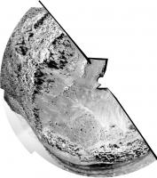
Posted by: vikingmars Apr 27 2014, 05:18 PM
...and as a "donut" pan done for the fun of it. Enjoy also !

|
Posted by: Ant103 Apr 27 2014, 05:57 PM
Ahh, you where faster than me Olivier 
But anyway, my take
http://www.db-prods.net/marsroversimages/Curiosity/2014/Sol610_pano.jpg
Posted by: vikingmars Apr 27 2014, 06:46 PM
How nice Damia ! Your pans are always great ! Thanks so much 
Posted by: Phil Stooke Apr 27 2014, 08:53 PM
Yes - great! For some reason I couldn't download it but I will try again later. Meanwhile I could not resist making a circular version from Olivier's panorama.
Phil
|
Posted by: vikingmars Apr 27 2014, 09:14 PM
Thanks so much Phil for this "Philo'Vision" !!! How nice (and fun too) to see it : I'll share it on my Facebook page (naming you of course) !
Posted by: mcaplinger Apr 28 2014, 12:20 AM
Is it just me, or does all the arm hardware show up twice in this mosaic?
Posted by: djellison Apr 28 2014, 01:39 AM
I think it was stowed for the top tier and deployed for the couple of frames on the bottom.
Posted by: anticitizen2 Apr 28 2014, 02:47 AM
Watch the drill pre-load tilt the rover
http://i.imgur.com/AC11xEv.gif
Here is the arm action for this weekend combined (Pre-DRT APXS, overnight APXS, and drill placement)
http://i.imgur.com/hc8KBNa.gif
Can't wait for the MAHLI self-portrait to come down!
http://i.imgur.com/WQtY3yD.gif
They're not in order, but the spin looks more exciting that way
http://i.imgur.com/rAGgMsU.jpg
http://i.imgur.com/MGqZxsr.gif"
Posted by: mcaplinger Apr 28 2014, 06:14 AM
I don't want to see mosaics that have sensor smear off the RTG this time.
Posted by: jvandriel Apr 28 2014, 06:38 AM
Mahli selfie on Sol 613 ( but not complete )
Jan van Driel

|
Posted by: James Sorenson Apr 28 2014, 07:06 AM
Jan, be courteous to the whole rover team and use proper credits please.
http://www.unmannedspaceflight.com/index.php?s=&showtopic=7522&view=findpost&p=193963
ADMIN: We agree. A good time to remind everyone. http://www.unmannedspaceflight.com/index.php?showtopic=7375&view=findpost&p=189703.
Posted by: Phil Stooke Apr 28 2014, 08:31 AM
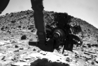
This is the post-preload MAHLI image showing the two contact points - the drill would be at the midpoint between them if they drill exactly here.
Thanks, Mike and all the MSSS team for some truly remarkable cameras.
Phil

|
Posted by: Ant103 Apr 28 2014, 09:55 AM
Oh yeah ! A selfie !! ^^ And I just love the way the Mast cameras are pointing, not directly toward the MaHLI. There is a pretty huge amount of dust deposition of the rover deck, I was pretty surprised to see so much dust O_o
http://www.db-prods.net/marsroversimages/curiosity-2014.html#81
EDIT : Panorama now complete
Posted by: Ant103 Apr 28 2014, 10:15 AM
Ah yes ! I've decided to add a frame taken two sols later in order to showing the roboting arm investigate the rocks. And so, we can see this arm twice. I've never thought of that "surrealistic" thing.
Posted by: MahFL Apr 28 2014, 10:28 AM
What I find fascinating is the trails made in the dust by moving pebbles on the deck.
Posted by: James Sorenson Apr 28 2014, 01:46 PM
Here is a crop of my version sofar with a fun animated GIF
https://flic.kr/p/npz7Y1
Animated GIF:
https://www.flickr.com/photos/43581439@N08/14050234054/sizes/o/
Posted by: jvandriel Apr 28 2014, 07:13 PM
Sol 613 Curiosity selfie complete.
Jan van Driel

|
Posted by: djellison Apr 28 2014, 10:21 PM
My go at it!
http://dougellison.smugmug.com/Landscapes/Curiosity/i-h8tgjCn/A
Used an old trick from processing MOC imagery - take a version of images with that vertical streak - reduce to 1 pixel height - stretch back out to full size, invert, and then use to back out that bright streak. Works pretty well.
|
Posted by: Ant103 Apr 28 2014, 10:59 PM
Amazing work Doug, especially on the projection, very hard here ! It looks like it's a stereographic projection I guess
My last take on this selfie with a Postcard :
http://www.db-prods.net/blog/2014/04/29/carte-postale-curiosity-autoportrait-a-the-kimberley-sol-613/
Posted by: djellison Apr 29 2014, 12:05 AM
I used PTGui with a Stereographic-Down projection.
Posted by: vikingmars Apr 29 2014, 08:58 AM
Thanks a lot Doug : how nice !!!
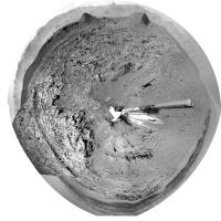
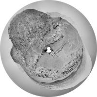
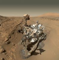
My interpretation of Sol 613 MAHLI mosaic. Here is the result (reduced format to fit in the Forum).
On my side, I chose to render a "fisheye" view centered on the axis of the Robotic Arm, which seems to be more geometrically correct and keeps the perspective as it is when the pictures where taken, i.e. the left-front wheel is bigger, because it was much more closer to the camera (which was hovering above it) than the right-front one at the background... Enjoy !

|
Posted by: James Sorenson Apr 29 2014, 09:01 AM
Here is a rough draft screenshot which combines the Sol-610 M34 360 pan, and the selfie. I have a bunch of work to do on it still, but I can't hold this back.

|
Posted by: wildespace Apr 29 2014, 09:06 AM
An interactive version of the Sol 613 selfie at Photosynth.com, assembled in Microsoft ICE - http://photosynth.net/view.aspx?cid=7af62022-db37-45a1-b1f4-275bebf81db7

|
So much dust!

Love the detail in the sand where the front right wheel disturbed it.
[Edit] Just noticed tiny "landslides" in the sand just in front of the rover. The result of the drill test?
|
http://mars.jpl.nasa.gov/msl-raw-images/msss/00613/mhli/0613MH0003900000203405E00_DXXX.jpg
Posted by: vikingmars Apr 29 2014, 09:17 AM
How nice James ! Thanks a lot
Posted by: fredk Apr 29 2014, 03:02 PM
No - those slides were there even on sol 606, before we approached the drill site:

|
See also http://www.unmannedspaceflight.com/index.php?s=&showtopic=7828&view=findpost&p=209200
Posted by: Gerald Apr 29 2014, 03:03 PM
Seems to have been looking the same on Sol 606:
http://mars.jpl.nasa.gov/msl-raw-images/msss/00606/mcam/0606MR0025570300400963E01_DXXX.jpg
Posted by: James Sorenson Apr 29 2014, 06:03 PM
If you notice, there is a fair amount of dust deposition on that landslide over the dark regolith. That says something about how old this is. So it wasn't caused by the rover. However might want to watch for these when or if we drill here.
Posted by: neo56 Apr 29 2014, 07:06 PM
My take on Curiosity self-portrait with head position n°1. I chose stereographic projection. I manually corrected "black dots" due to dust on MAHLI camera by cloning adjacent homogeneous areas.
Full size:
https://www.flickr.com/photos/105035663@N07/14067134615/
Cropped:
https://www.flickr.com/photos/105035663@N07/14067021355/
http://www.gigapan.com/gigapans/155018
Posted by: anticitizen2 Apr 30 2014, 03:17 AM
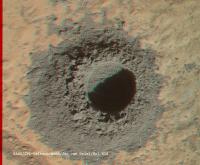
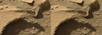
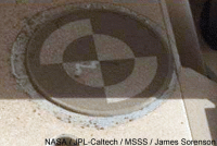
We have a drill hole!!
http://i.imgur.com/NrsIAzT.gif
http://i.imgur.com/abK69bB.gif
edit: good catch, James, I didn't notice it. Here's a brightened before/after and http://i.imgur.com/oCFBEkL.gif
Posted by: James Sorenson Apr 30 2014, 03:28 AM
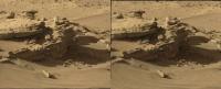
looks like some very different stuff than what we saw at Yellowknife bay. Also, a big slide happened as well.
http://mars.jpl.nasa.gov/msl-raw-images/msss/00615/mhli/0615MH0003920030203462C00_DXXX.jpg
Posted by: jvandriel Apr 30 2014, 08:06 AM
Sol 615 MAHLI.
The drilled hole in stereo.
Jan van Driel
|
Posted by: Ant103 Apr 30 2014, 10:32 AM
I'm very intrigued by this landslide of the sand. No direct contact, just vibrations, and the sand is going down. What we know about martian sands is that it's very cohesive, in cause of magnetic particles inside. Martian sand is like a wet sand, but with no water. Here the case is different, and it behaves just like traditional sand. Maybe it will be interesting to investigate a bit this case ?
Posted by: Actionman Apr 30 2014, 11:15 AM
The material seems to be more sand like then dust and less rock like and more like dirt.
Posted by: serpens Apr 30 2014, 01:30 PM
That is pretty shallow. Did they do a mini drill hole to characterise before a full depth drill, as they did at John Klein? I don't seem to see any significant slide in the spoil?
Posted by: elakdawalla Apr 30 2014, 02:25 PM
http://mars.jpl.nasa.gov/news/whatsnew/index.cfm?FuseAction=ShowNews&NewsID=1630
Posted by: elakdawalla Apr 30 2014, 02:26 PM
Damia, cohesion of soil on Mars has nothing to do with magnetic particles. It's fine and very dry so coheres to some extent, but we've seen cascades of windblown drifted sand all over the place here; I'd have been surprised *not* to see it happen in response to percussive drilling.
Posted by: wildespace Apr 30 2014, 03:07 PM
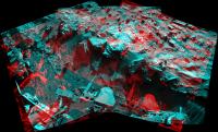
A grey-scale anaglyph of the drilled hole. I also made the pile of drilled material stand "above" the screen.

|
Any guesses as to why the drilled rock is so dark?
By the way, I find that grey-scale anaglyphs work better than colour ones. The lightness discrepancy between reddish and bluish/greenish hues that each eye receives often create a glittering effect (for example, a red apple will appear lighter through the red filter and darker through the cyan or blue filter). The anaglyph glasses render our perception of colours invalid anyway.
Posted by: Gerald Apr 30 2014, 03:46 PM
Direct Sol 180 - Sol 316 comparison:

|
A couple of out-of the-hip hypotheses for the darker drill tailings:
- less calcium sulfate contents,
- more unaltered basalt contents,
- coarser grains.
Edit: The nice Sol 615 5x5 LIBS raster will provide a first survey of grain size, and elemental composition.
MAHLI Sol 612/615, before/after LIBS animated gif: http://imgur.com/NDl4LyA
Posted by: jmknapp Apr 30 2014, 11:23 PM
Another comparison:

|
Magnetite/hematite would be cool.
Posted by: serpens May 1 2014, 12:05 AM
If we accept that the ubiquitous dust should be the same colour at both sites (with a fudge factor for sun position) the new tailings should be a touch lighter than in Joe's comparison image. The Yellowknife Bay drills were into clay rich mudstone formed by fine sediment at the bottom of a lake. This seems more of a very well cemented, fine sandstone, and my punt based on previous images remains a topset formation.
Posted by: jmknapp May 1 2014, 11:54 AM
OK, maybe this matches the dusty backgrounds a little more closely:

|
Posted by: Gerald May 1 2014, 01:16 PM
I'd expect http://itc.gsw.edu/faculty/bcarter/physgeol/min/prop3.htm tailings to look reddish.
Some magnetite could be.
Any informatiom about how long the drill took? By comparing the drill time with the YB drill times, we could learn more about the hardness of the rock.
Posted by: anticitizen2 May 1 2014, 01:33 PM
Judging by the timestamps on the Haz before/after, right around half an hour.
Edit: more full resolution images are down, it looks to be a little less than 25 minutes
Posted by: Nirgal May 1 2014, 01:35 PM
kudos^2, Doug !
this one is about as perfect as it gets: projection, composition/cropping, color grading ...
I imagine the hollywood movie poster for James Cameron's Mars/MSL film that he once planned would have looked exactly like this
Posted by: djellison May 1 2014, 02:54 PM
That image received 898,002 views on the 29th alone, over 954,000 in total. Thanks Reddit. 
Posted by: anticitizen2 May 1 2014, 07:23 PM
Coooooooooooool.
http://i.imgur.com/j686zHM.gif
Full resolution linked
http://i.imgur.com/YVV7g9w.gif
barrage of edits to get the versions right. http://i.imgur.com/SLuICwB.gif
responding to neo56: Amazing comparison, Thomas! It looks so perfect that you know a ton of effort went into making it.
Posted by: neo56 May 1 2014, 07:48 PM
WOW !!! Very impressive animation !
Here is another animated gif showing dust deposition on Curiosity between sols 84 and 613:
https://www.flickr.com/photos/105035663@N07/14081435735/sizes/o/in/photostream/
Posted by: elakdawalla May 1 2014, 08:37 PM
So far Doug is the only person who's heeded Mike's admonition, so http://www.planetary.org/blogs/emily-lakdawalla/2014/0501-image-processing-trick-interline-transfer-smear.html! I used Photoshop but they're pretty basic tricks, available in GIMP too.
Posted by: djellison May 1 2014, 09:31 PM
If it gets you down too much - just think of it as motion blur.
Posted by: mcaplinger May 1 2014, 10:16 PM
Before Doug's version, the smear was serving as a useful amateur watermark. Soon we won't even have to bother to make our own processed version (though you'll have to trust me that our internal version is better than any of yours. )
Posted by: walfy May 1 2014, 11:12 PM
Threw together recent drilling sequence, part of it in 3D. 
Posted by: serpens May 1 2014, 11:14 PM
That is fascinating. Really well done.
Posted by: elakdawalla May 1 2014, 11:30 PM
Walfy, check your text, you've named the wrong rover
Posted by: Gerald May 2 2014, 12:05 AM
Trying a first hardness estimate of the Sol 615 Windjana target in comparison to Cumberland Sol 279:
http://imgur.com/TkVIaJ7
If all other conditions for the drilling of Cumberand and Windjana have been the same (load, drill mode, no interruptions), the Windjana rock should be about (6 to 7) 5 to 6 times more resistant to drilling than the Cumberland rock.
Edit: Fixed typo in above graphics.
Posted by: CosmicRocker May 2 2014, 02:10 AM
Fascinating indeed. I was originally skeptical that the rover would be able to trigger the many "mini-landslides" that we have been seeing everywhere by simply driving nearby, but after seeing all these effects caused by the surely lower amplitude vibrations of the drill, I must reconsider.

Posted by: fredk May 2 2014, 04:10 AM
Is it clear the effects of driving should be bigger? We're talking very slow rolling motion versus some pretty mean hammer action...
Posted by: nprev May 2 2014, 04:28 AM
Odd thought here: Does the apparently easy slumping of these aeolian deposits indicate that indigenous Marsquakes are rare indeed?
It'd be interesting to see how many slump events happen in the vicinity of those smaller impacts that happen all the time, and how far away from the crater itself they would be observed.
Posted by: CosmicRocker May 2 2014, 06:22 AM
fredk: It's probably not perfectly clear, but my thought was based on the assumption that a wheel slipping off the edge of a rock could exert a greater impact than that of a tool held down by a flexible robotic arm.
Now that you've called me on it, I was surprised to read that the arm can stabilize its drill against a rock with up to 300 newtons of force (~67 lbf.)! Reading further, though, it appears the drill bit can deliver a relatively small amount of energy per impact, though there are many impacts each second.
It could be a fun exercise in physics to calculate some comparison cases, but it is getting too late on this end for me to do the remaining research to even begin the calcs. I think I'll sleep on it.
One thing that seems clear with regard to these minislides is that these sandy sediments must often be sitting at very nearly their "angle of repose." In such a condition, these sloping sediments would require very little energy to cause parts of them to fail. One of my initial hypotheses was that they might be triggered by the laser ablations of the chemcam. I didn't do an extensive search, but I didn't find any evidence of that.
nprev: That's a good question. Most of these minislides seem to be very recent, but short of before/after photos, they will be difficult to date. You might be able to assume they all post-date the last major sandstorm in this region. Slumpings from prior to the last storm are likely to be covered over. 
Posted by: serpens May 2 2014, 06:30 AM
I suspect that in this case the vibrations were transmitted through the rock which is continuous (no desiccation cracks) and solidly cemented, providing limited attenuation. The fine dust piles overlay the rock. It would possibly be the continuing, periodic vibration cycle from the percussion drill that provided the stimulus for the slides and possibly some resonance effects existed, so mars quakes (transmitted shock from impacts) may not have as significant an effect.
Gerald's rough estimate of a comparison ratio for drill resistance (as opposed to hardness) is interesting also. I gather that the primary effect of the drill is comminution so the difference in time would reflect fracture resistance as a function of cementing and particle size.
Posted by: CosmicRocker May 2 2014, 06:53 AM
Yeah. I find this subject very fascinating. Why does this rover observe so many apparently recent, mini-mass-wastings in the loose sediments near its path?
Are we driving through a field of these disturbances, or are these observations somehow caused by the rover's presence? I wonder if Heisenburg has an opinion.
Posted by: Phil Stooke May 2 2014, 08:06 AM
That notorious waffler? I doubt it.
As Fredk said, the drilling is a rather violent process. I would expect far more slumping from a drill event than just driving slowly by at a distance. And don't forget - Viking lander 1 saw two slumps like these actually happen a few tens of meters away from it as it sat motionless, two events in three Mars years.
Phil
Posted by: Gerald May 2 2014, 09:17 AM
This animated gif marks some of the pebbles displaced by the http://en.wikipedia.org/wiki/Seismic_wave, caused by the percussion:
http://imgur.com/yYGOnAv
(The high acceleration of the percussion is sufficient to crush rock, as part of the drilling.)
Posted by: serpens May 2 2014, 09:35 AM
I feel that it would be a mistake to attribute these slides to any one influence. The drill was a strange and unusual event in Martian terms that caused what could be termed catastrophic effects in an extremely short timeframe. But it is evident that such slides occur periodically (where the period could be measured in years, decades or even millennia) sans rover. Here in Gale the slides seem associated with proximity to rocks or ridges. The measured, daily ground temperate range is a low of around 80 degrees Celcius and a high of 100 degrees so thermal expansion/contraction of the rock, although probably minor, could perhaps be one stimulus.
The slips seem to reveal dark silt/sand covered by a deposit of lighter Mars dust (which Curiosity is also collecting). Given the colour of the drill tailings the dark material is potentially the product of local erosion. A comparative lasering of dust and tailings could be revealing.
Posted by: Gerald May 2 2014, 11:12 AM
The 3-image animated gif below magnifies and stretches brightness of a subframe of these three Sol 615 HazCam B images:
http://mars.jpl.nasa.gov/msl-raw-images/proj/msl/redops/ods/surface/sol/00615/opgs/edr/fcam/FRB_452087912EDR_S0311330FHAZ00214M_.JPG
http://mars.jpl.nasa.gov/msl-raw-images/proj/msl/redops/ods/surface/sol/00615/opgs/edr/fcam/FRB_452088317EDR_S0311330FHAZ00214M_.JPG
http://mars.jpl.nasa.gov/msl-raw-images/proj/msl/redops/ods/surface/sol/00615/opgs/edr/fcam/FRB_452088822EDR_S0311330FHAZ00214M_.JPG

|
The contrast between the old slide and the new one should provide additional evidence, that the old slide hasn't taken place quite recently.
Posted by: anticitizen2 May 2 2014, 01:39 PM
I'm fascinated by the different surface gravity, so I made a greatly enlarged loop of the main flow.
http://i.imgur.com/LnRXK6C.gif
Posted by: pospa May 2 2014, 03:54 PM
It could be hardly better than this: http://www.360cities.net/image/mars-panorama-curiosity-solar-day-213
Just switch to full screen, hide controls and you are there, 2 meters above LF wheel.
Posted by: vikingmars May 2 2014, 04:29 PM
Just switch to full screen, hide controls and you are there, 2 meters above LF wheel.
How nice ! Thanks a lot Pospa !!!!!
Posted by: djellison May 2 2014, 04:42 PM
Note - the rover can not look at loose sediments NOT near it's path. Observational bias.
If any of you are in doubt, btw, the MSL drill is powerful, it's loud, it's highly energetic. I saw an EM in action, and even from 5-10ft away, it was fingers-in-ears loud.
https://www.youtube.com/watch?v=GrfM9dbd1e0
https://www.youtube.com/watch?v=T3nSHi14dUM
Posted by: JRehling May 2 2014, 04:54 PM
Piles of loose material slump to their angle of repose and at that point are in a state of fragile stability. Any new shock larger than that which was previously encountered can cause a new collapse.
I remember trying to climb a rather modest dune in Death Valley and being almost unable to because every step I took caused a down-slope collapse of the material upon which I was trying to walk upwards.
Typical locations on Earth can go centuries between noticeable (> magnitude ~3.5) earthquakes, so I would expect that a typical location on Mars goes through at least thousands of seasonal dust depositions between being shocked by anything... until a lumbering, poking, prodding rover from Earth shows up.
Posted by: serpens May 3 2014, 12:12 AM
Overall, Gale is in an erosional phase. A very benign phase given the total lack of moisture and near vacuum, so minor build up of fine, eroded particles and intermittent mass wasting in the form of small slides, over a very long timescale, could reasonably be expected. As noted by atomoid, the surface particles seem to be mechanically locked by dust, as opposed to the strong duricrust of Meridiani, so slopes would seem to be generally stabilised, but vulnerable to external influences such as additional load from dust deposition or vibration.
While the collateral damage to the landscape induced by the drill is of passing interest, more for the superb image processing
and animations than anything else, it is the deeper drilling, sample collection and analysis that I am awaiting with eager anticipation. Fredk drew attention to this extremely fine, erosional lattice work, confirming the benign erosional processes and stable environment . As previously pointed out this demonstrates that the cementing in the Kimberley region is extremely strong and the lack of any reddish hue in the tailings provides a pseudo scratch test rendering hematite unlikely. In fact wouldn't the dark grey colour seem to point towards reducing conditions?
|
Posted by: Gerald May 3 2014, 12:32 AM
It would be very surprising, if the rocks would turn out to be fully oxidized, at least.
Any idea, what the cement could be made of?
I tend to rule out clay minerals and gypsum as the main constituents of the cement, since even with very low porosity, the drill resistance would be unexpected high. On the other hand, silica as cement would probably be even more resistant.
Could calcite be an option, without wanting to seed unbased hope?
Posted by: serpens May 3 2014, 01:12 AM
Given that the MSL team have identified variations in hardness (cementing) of the target sandstone, let alone variation in layers there is probably a mix. The puzzle will be to sort out the mix and Kimberley could well throw up a few surprises. While some clay and calcium sulphate veins could be anticipated, if your comparison of drill resistance is reasonably accurate then the primary cement is potentially siliceous but we have to wait and see.
Posted by: atomoid May 3 2014, 02:05 AM
that is really an(other) http://www.midnightplanets.com/web/MSL/image/00601/0601MR0025370520400818E01_DXXX.html i missed! i don't suspect anything quite like this could persist even in the driest deserts of Earth (lest get so far along).

|
Posted by: serpens May 3 2014, 03:37 AM
Yep, as you may gather it got me all flustered because of what I think we can deduce from this rather beautiful eroded lamination. For example the demonstrated geomechanical strength would seem to necessitate both interlocking of grains and a very high cement content. The cement content rather than the type of cement is the critical parameter with the implication of a very long lasting water table post deposition. Another important factor is that to achieve the necessary density (lack of porosity) this sandstone must have been reasonably deeply buried which puts a tick on the side of Gale having been at least partially filled and then exhumed, with implications for Mount Sharpe. Finally sandstone strength, regardless of the cement type, is greatly affected by moisture which could imply that the purported overnight transfer of small quantities of atmospheric water into surface overnight is in fact merely frost deposition which sublimates without any intermediate water film. I would appreciate a slap over the knuckles from the experts on the forum if any of the above represents a flight of fantasy from an ageing brain.
Posted by: neo56 May 3 2014, 08:53 AM
Nice pictures of MAHLI camera on sol 617:
http://mars.jpl.nasa.gov/msl/multimedia/raw/?rawid=0617ML0026370000301837E01_DXXX&s=617
http://mars.jpl.nasa.gov/msl/multimedia/raw/?rawid=0617MR0026380030401081E01_DXXX&s=617
Posted by: neo56 May 3 2014, 09:14 AM
Panorama taken on sol 617 with MC100 (not yet complete):
https://www.flickr.com/photos/105035663@N07/13908133460/
There is a very beautiful specular reflection on a rock just behind the drill site.
Posted by: jvandriel May 3 2014, 09:55 AM
The panoramic view on Sol 610 taken with the Mastcam L cam.
Jan van Driel

|
Posted by: fredk May 3 2014, 03:20 PM
That's caught my eye too. It's thanks to a blast from LIBS:
http://mars.jpl.nasa.gov/msl-raw-images/proj/msl/redops/ods/surface/sol/00611/opgs/edr/ccam/CR0_451743790EDR_F0311330CCAM06611M_.JPG
Posted by: fredk May 3 2014, 08:23 PM
Do you seek a peek through the beak?
anaglyph:

|
cross-eyed:
|
(Both images un-tweaked.)
Posted by: atomoid May 3 2014, 10:25 PM
hadnt noticed the character of the 'slide' here before, seems drill vibration moved a loosely-cohesive http://www.midnightplanets.com/web/MSL/image/00617/0617MR0026000100401092E01_DXXX.html en-masse over the rock surface at right as evidenced by glaicialesque stripes..

|
also, an http://www.midnightplanets.com/web/MSL/image/00617/0617MR0026000830401165E01_DXXX.html from last 'season' ?? and.. eh, http://www.midnightplanets.com/web/MSL/image/00617/0617MR0026000840401166E01_DXXX.html?
Posted by: vikingmars May 4 2014, 09:31 AM
WOW ! You have just discovered a new RSL ! Show it to Lujendra Ojha !
Posted by: jvandriel May 4 2014, 02:37 PM
The Chemcam panorama of the drilled hole taken on Sol 619.
Jan van Driel

|
Posted by: neo56 May 4 2014, 07:22 PM
Curiosity self-portrait now corrected from the interline transfer smear off the RTG. Thanks Emily for your tutorial! It works perfectly on Gimp.
Full size:
https://www.flickr.com/photos/105035663@N07/14067134615/
Cropped version:
https://www.flickr.com/photos/105035663@N07/14067021355/
Posted by: neo56 May 5 2014, 01:58 PM
Panorama of Windjana drill site taken with MC100 now updated:
https://www.flickr.com/photos/105035663@N07/13908133460/
http://www.gigapan.com/gigapans/154451
I'm working on adding MC100 pictures taken on sol 618 at same local time. It'll make a huge high resolution panorama! 
Posted by: atomoid May 6 2014, 01:33 AM
particularly mesmerizing http://www.midnightplanets.com/web/MSL/image/00618/0618MR0026010580401327E01_DXXX.html around these parts..

|
|
 is that Fredk's silhouette guy relaxing in the ledge?
more 'http://www.midnightplanets.com/web/MSL/image/00618/0618MR0026011060401375E01_DXXX.html' RSL (er, dusted over!) past-season http://www.midnightplanets.com/web/MSL/image/00618/0618MR0026011060401375E01_DXXX.html?
Posted by: PaulH51 May 6 2014, 11:20 AM
Judging by the amount of tailings and the slight countersinking of the tailings on the left hand rim of the new hole, I think it highly probable that we have another full depth hole on Mars And a powder sample transferred into CHIMRA Well done JPL....
http://mars.jpl.nasa.gov/msl-raw-images/proj/msl/redops/ods/surface/sol/00621/opgs/edr/ncam/NRB_452627091EDR_F0311330NCAM00376M_.JPGto NavCam image of Winfjanna
Posted by: Gerald May 6 2014, 02:59 PM
The new drill hole is on the brushed and LIBS'ed patch, NRB Sol 620/621 before after gif:

|
(cropped, and resized to about 150% after geometric adjustments)
I'm sure, we'll get better images, soon...
... and an entirely new data point regarding mineralogical composition.
Posted by: anticitizen2 May 6 2014, 03:03 PM
Excellent panoramas! So many wonderful pictures of this location.
Full Haz - http://i.imgur.com/FfQSvEi.gif
Full RNav - http://i.imgur.com/zzYLYPO.gif
Showing the new slide - http://i.imgur.com/x8IZN5M.gif
Larger version showing the two slides - http://i.imgur.com/BG9EVPb.gif
More shifty rocks
Posted by: Phil Stooke May 6 2014, 10:23 PM
Yikes, don't stub your toe on the unconformity (and look out for the Manta Ray too).
Phil
http://www.midnightplanets.com/web/MSL/image/00620/0620MR0026030240401513E01_DXXX.html
Posted by: anticitizen2 May 6 2014, 10:39 PM
Is Curiosity doing a push-up, or a Mars-down?
https://i.imgur.com/5hfU3CH.gif
Movement removed - https://i.imgur.com/Kvk55b1.gif
Nicer Nav before/after - https://i.imgur.com/snKBseF.gif
Posted by: Floyd May 6 2014, 11:48 PM
Pressing down on the contact points to stabilize drilling does change weight distribution on the rover just a bit--and it tilts.
Posted by: Ant103 May 7 2014, 09:19 AM
I can't leave my eyes from contemplating the mountains of Gale Crater's rim. So many details, so much to see
Sol 618 Mastcam100 mosaic.
http://www.db-prods.net/marsroversimages/curiosity-2014.html#82
Posted by: Gerald May 7 2014, 12:32 PM
Sol 621 MR before/after drill is now available:
http://imgur.com/0C3jPIb
And a ML/MR x-eye stereo:
http://imgur.com/HubaOS7
Posted by: anticitizen2 May 7 2014, 02:00 PM
I was joking, Floyd 
Curiosity is soo massive, she stays still and rotates the planet beneath her 
I agree Damia, Gale still takes my breath away. I especially like the craters in the rim. Thanks for my new desktop image!
http://i.imgur.com/RFXSBvq.gif
http://i.imgur.com/NILQIPV.gif
http://i.imgur.com/Q9eagzn.gif
Two frames of the full-depth drill Haz sequence are corrupted, and I know I should wait for the re-transmitted images in a few hours, but I didn't
Here are the two drilling sequences combined - http://i.imgur.com/5ObFoCg.gif
I'll have a better one with the two frames included when they arrive
edit: lastly, is there any easy way to find old images of the drill bit for comparison?
Posted by: Gerald May 7 2014, 04:47 PM
This is a try of a Sol 622 ChemCam / Sol 621 Right Mastcam x-eyed stereo:

|
Posted by: neo56 May 7 2014, 05:35 PM
Complete panorama taken on sol 618 with MC100:
https://www.flickr.com/photos/105035663@N07/13944454620/
http://www.gigapan.com/gigapans/154570
You're right Damia, there are so many details on the wall of Gale crater! I stretched levels and contrast to emphasize these details:
https://www.flickr.com/photos/105035663@N07/14108458436/
Posted by: ngunn May 7 2014, 09:18 PM
Does that image show the major unconformity between the striated unit and the flat-lying beds above it or is this a smaller feature within one of the units? I ask because the angle is greater than I was expecting if it's the former.
Posted by: anticitizen2 May 7 2014, 11:39 PM
Still missing those two frames, but a bunch more came down
http://i.imgur.com/mVLMJYx.gif
Brightened/sharpened version:
http://i.imgur.com/fvsU0hp.gif
Posted by: elakdawalla May 8 2014, 12:31 AM
Is that a specular reflection from something shining on the back of the turret during the full drill? What's that reflecting from, I wonder?
Posted by: serpens May 8 2014, 12:32 AM
What angle are you referring to ngunn? I'm not sure that we should persist in using striated unit in relation to what is clearly a depositional effect.
Posted by: eoincampbell May 8 2014, 12:41 AM
 Wow, it's kinda spooky... miniature martian ball lightning..?
Posted by: ngunn May 8 2014, 05:55 AM
I was asking about the angle of about 18 degrees between the two sets of strata in the image Phil linked- http://www.midnightplanets.com/web/MSL/image/00620/0620MR0026030240401513E01_DXXX.html.
(The striated unit will no doubt get a different name in due course, but meanwhile we have to call it something.)
Posted by: serpens May 8 2014, 06:36 AM
This structure and the dip seems pretty compatible with a delta foreset / topset formation. Aeolian or surge deposits seem unlikely. If this unconformity was an erosional truncation of dipping strata I think the boundary would be more uneven.
Posted by: ngunn May 8 2014, 08:59 AM
You may well be right, but I note that the 'striations' seen by HiRise seem to show a very consistent trend over many kilometers and that the trend is pretty much parallel to the crater rim.
Anyhow, perhaps someone can help answer my original query. Does Phil's linked image show the actual contact between the two HiRise units?
Posted by: jmknapp May 8 2014, 09:46 AM
Maybe the ChemCam lens? Since the spot is above the NAVCAM optical axis and the Sun is above everything in the frame I think that means the reflecting point is likely to be above the NAVCAM axis, so that points to ChemCam. It also appears to be a nice big circular spot. Good thing there are no cats on Mars.
Posted by: PaulH51 May 8 2014, 11:40 AM
Check out the rock in shadow below the right hand drill support post during the frames for the mini drill test, there is a moving bright spot that may be a reflection from the same source.
If it is the same "reflector", could the different location of the bright spots be explained by the small time differences between the mini drill and full depth drilling?
Posted by: djellison May 8 2014, 01:33 PM
The mast is typically commanded to point away from a drill site when drilling is taking place, so that seems unlikely.
Posted by: mcaplinger May 8 2014, 01:37 PM
That was my guess. (BTW, technically, it's a window, not a lens -- see http://mappingignorance.org/2013/03/05/laser-spectrochemistry-beyond-earths-boundaries-curiositys-chemcam/ )
Posted by: fredk May 8 2014, 03:20 PM
I don't know what the covers/windows are like - in particular, are they flat? If they are then it seems unlikely they could cause such a reflection. Take a flat circular mirror and look at the reflection it causes from the sun - it will have at least the diameter of the mirror (the same diameter for a close reflection, and larger and fuzzier for more distant reflections). This bright spot looks smaller and sharper than I'd expect from any mast window reflection.
With a curved aperature then you could get a focused spot, although that would require the right curvature. Of course there are curved surfaces behind the windows even if the windows are flat.
Generally getting a small reflected spot is easier the closer the reflector is to the reflection. So I'd guess a reflection from some part of the arm/turret would be most likely.
Posted by: Gerald May 8 2014, 03:45 PM
Some intermediate Sol 621 FLB drill image sequence analysis:
Cropped, 5x-magnified, registered to the drill bit:
http://imgur.com/L5ilgEN
Raw estimated (vertical) registering data: Sol621_drilling_time_csv.txt ( 542bytes )
: 245
Sol621_drilling_time_csv.txt ( 542bytes )
: 245
Resulting drilling progress - drilling time diagram:

|
Posted by: Deimos May 8 2014, 05:13 PM
At the other extreme, a small, flat reflector is a pinhole camera. If the image were projected from close to the camera, it could even show an undistorted, round Sun. How it might move in such a way without >1 reflection, I do not know.
Posted by: Gerald May 8 2014, 07:40 PM
If I calculated roughly correctly, a potentially reflecting object should be a little more than one third (about 37%) the distance from the turret than the Right HazCam, if it's roughly on the same line.
This is by comparing the angle the apparent sun should have travelled relative to HazCam with the distance the bright spot travelled the same time:

|
For most other angles between Sun and the reflecting object, the distance to the turret should be even smaller, since we are looking almost perpendicular to the projection plane.
Thus, a feature on the rover arm could be a candidate.
But shouldn't a spot caused by a single reflection (of a plan mirroring surface) travel the opposite direction of the sun, whereas the bright spot appears to travel parallel to the sun? If so, we need two subsequent reflections.
This cropped and magnified HazCam image makes me doubt a bit, too:

|
The spot is bright, although the angle for reflecting or straying back to HazCam seems less favorable than in other HazCam images.
Could the spot be a reflection of the sun within the HazCam optical system, although the sun is outside the fov? But how can it be fucused in this case?
Posted by: Deimos May 8 2014, 09:25 PM
Go back to the start of the sequence, and you'll find the spot already there. But [... wait for it ...] in a completely different spot of the other FCAM and absent from the subsequent NCAMs.
- http://www.midnightplanets.com/web/MSL/image/00621/FRB_452623428EDR_F0311330FHAZ00211M_.html <-- there's a stretch SUV in the sky of this, too, but not in the FLB image, so it may not be a *real* flying stretch SUV
- http://www.midnightplanets.com/web/MSL/image/00621/FLB_452623428EDR_F0311330FHAZ00211M_.html <-- spot is on arm
- http://www.midnightplanets.com/web/MSL/image/00621/NLB_452623472EDR_F0311330NCAM00226M_.html <--later but the spot remains in subsequent FRB images.
Posted by: djellison May 8 2014, 10:27 PM
For ChemCam - yes - I believe the window is flat. The mirror behind it is concave obviously.
However as I've already said - the mast is typically pointed away from drill sites during drilling. We were explicitly told to show that when the rover is doing drilling - the mast looks about 120deg right of forwards - as away from drill sites as possible
https://www.youtube.com/watch?v=P4boyXQuUIw#t=541
(9 mins / 540 seconds in)
Posted by: mcaplinger May 8 2014, 10:56 PM
There's a flat window, an oddly-curved Schmidt corrector and the secondary, and then the primary. But I hadn't worked out how large a reflection from a flat window would be.
The Navcams have a flat ND filter on the front (they look shiny) so it might be that. I believe Doug when he says he was told the mast was pointed away during drilling, but obviously one could confirm this by looking at the SPICE kernels. I don't know what's going on, and I'm afraid to ask after the kerfuffle with the cosmic rays/pinholes/whatever.
Posted by: jmknapp May 8 2014, 11:17 PM
Per SPICE FWIW, the image http://mars.jpl.nasa.gov/msl-raw-images/proj/msl/redops/ods/surface/sol/00621/opgs/edr/fcam/FRB_452625579EDR_S0311330FHAZ00209M_.JPG was taken with the FRB axis at 307 degrees azimuth, and ChemCam was pointing at 355 degrees, -22 degrees elevation. Sun az/ael was 310/52.
Posted by: fredk May 8 2014, 11:38 PM
Posted by: Gerald May 8 2014, 11:48 PM
So it's either a "virtual" flying stretch SUV, or a reflection/artifact of the sun within the HazCams (here a gif with two 3x magnified Sol 621 Left HazCam images) :
|
Posted by: djellison May 9 2014, 12:56 AM
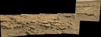
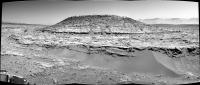
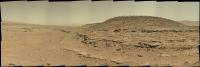
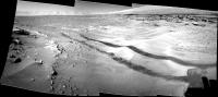
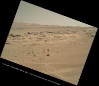
Sol 620 Pan looking toward the foothills of Mt Sharp.
Full Res here : http://dougellison.smugmug.com/Landscapes/Curiosity/i-Dz38BN5/0/O/0620MR-Panorama.jpg
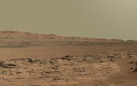
|
Posted by: elakdawalla May 9 2014, 12:56 AM
And THAT is exactly what I needed to cap my presentation at Spacefest tomorrow Thanks!
Posted by: Ron Hobbs May 9 2014, 03:43 AM
That is a stunning image! The foot of Aeolis Mons is SO clear. I would like to use it in my presentations as well.
Ron
Posted by: anticitizen2 May 9 2014, 01:39 PM
Watch rocks drawing their trails on the deck
http://i.imgur.com/SAcFUxX.gif
A sequence from sol 576 in honor of the recent sieving
http://i.imgur.com/28Kqd9h.gif
Those replacement frames from the full drilling were posted, so here is the final sequence
http://i.imgur.com/tGBlATs.gif
I thought I noticed some clouds, so I cut out the sky and tried to bring them out (though I still don't really know what I'm doing)
http://i.imgur.com/ilIdQkR.gif
Posted by: Dig May 9 2014, 02:11 PM
Initial assembly from the first full images arrived.
Sol 620 panorama Left Mastcam (M34).
Something contrast applied to the image to highlight details.
https://flic.kr/p/nxGCCs
Click image to enlarge
Posted by: vikingmars May 9 2014, 02:50 PM
How nice ! Thanks a lot Dig !
Posted by: fredk May 9 2014, 03:22 PM
|
|
Yeah, definitely looks like some kind of internal reflection inside the hazcam. It happened to sit on the turret in the frb sequence, but flb shows it moving off onto the background:
|
Any real (external) reflection onto the turret would be considerably blurrier if cast farther onto the background.
I guess these frames are looking fairly close to the line of sight towards the sun, which may explain why we haven't noticed such internal reflections before.
Posted by: Gerald May 9 2014, 04:36 PM
Left Mastcam Sol 623, successfull sample vibration:
http://imgur.com/NhfuTUP
(Edit: replaced gif by registered version)
Posted by: James Sorenson May 9 2014, 04:59 PM
"M" for Mars...

|
Posted by: walfy May 10 2014, 06:42 AM
Full Res here : http://dougellison.smugmug.com/Landscapes/Curiosity/i-Dz38BN5/0/O/0620MR-Panorama.jpg
In the excellent hi-res pano above, the surface looks a bit rough beyond the first section of dunes and before the inverted river bed. Very interesting to see such detail emerging. Looking forward to driving through it!
Posted by: Dig May 10 2014, 10:19 AM
Sol 620 panorama Left Mastcam (M34) complete.
https://flic.kr/p/nwpFqq
Click on image for full resolution
Posted by: Gerald May 11 2014, 12:50 AM
Mastcam Left, Sol 624, probably before/after http://astrogeology.usgs.gov/news/astrogeology/sol-620-update-on-curiosity-from-usgs-scientist-ken-herkenhoff-drill-hole-completed:
http://imgur.com/3jWtXNR
(Note the changing powder of the flap.)
Edit: Windjana drill target comparison Mastcam Right Sol 621 / Sol 624:
http://imgur.com/SPeHUDw
Most obvious change: Dust "removal" by laser shots.
(MR position changed a bit.)
Edit: Sol 617 / 618 MAHLI dustcover open/close, seen from Mastcam Left:

|
Edit: X-eyed version of the Sol 617 / 618 MAHLI dustcover open/close 2-image sequence:
http://imgur.com/3clLekR
Posted by: vikingmars May 11 2014, 08:51 PM
I just love those rocky valleys... Some really worth some art... Enjoy !

|
Posted by: PaulH51 May 12 2014, 11:36 AM
Some down hole LIBS targets observed in this RMI from ChemCam on sol 626
http://mars.jpl.nasa.gov/msl-raw-images/proj/msl/redops/ods/surface/sol/00626/opgs/edr/ccam/CR0_453067621EDR_F0311330CCAM03625M_.JPGto raw image
Posted by: Gerald May 12 2014, 12:04 PM
... Flatfield adjustment and 20-pixel hipass sharpening reveals several-millimeter-sized heterogeneities:

|
Posted by: Gerald May 13 2014, 10:53 AM
A couple of beautiful Sol 627 MAHLI images are available.
Here a (cropped) stereo pair as x-eyed:
http://imgur.com/RWMiRdX
edit: ... and as anaglyph:
http://imgur.com/ST6kLc2
Posted by: PaulH51 May 13 2014, 11:03 AM
Here a (cropped) stereo pair as x-eyed:
The small grains on the left hand upper edge of the hole appear to be making an attempt at defying gravity
Could magnetism be playing a part? Hope we get a closer look, or maybe a stacked focus image so we can zoom in Posted by: Gerald May 13 2014, 11:30 AM
At Cumberland we had a few per cent magnetite abundancy (about 8% of the crystalline phase). http://en.wikipedia.org/wiki/Magnetite dust is very susceptible, even to weak magnetic fields. So you can't rule out some magnetism with certainty.
For very fine grains, below about 1 micrometer, short-distance http://en.wikipedia.org/wiki/Van_der_Waals_force come into play; they can be attractive and make dust adhere.
Due to the drilling into dry rock http://en.wikipedia.org/wiki/Triboelectric_effect may (and likely will) cause electrostatic charging.
But at the end, simple mechanical reasons will explain most of the macroscopic features we can see in the image.
Posted by: PaulH51 May 13 2014, 11:36 AM
Thanks for the detailed reply Gerald
Posted by: charborob May 13 2014, 04:12 PM
Was http://www.midnightplanets.com/web/MSL/image/00627/0627MH0001220010203567C00_DXXX.html cleaned before being hit by the laser, or did the laser blast blow the dust away?
Posted by: Gerald May 13 2014, 05:19 PM
It's (almost) for sure "just" due to the laser blast, compare e.g. http://mars.jpl.nasa.gov/msl-raw-images/msss/00613/mhli/0613MH0003880010203430C00_DXXX.jpg:
There is a sharply defined boundary of the cleaned area, which is rougly maintained http://mars.jpl.nasa.gov/msl-raw-images/msss/00615/mhli/0615MH0003880010203434C00_DXXX.jpg.
Besides from this, the cleaned area looks smaller in the Sol 627 image, DRT use at the border of the rock would probably be more risky, and there seems to be no before/after DRT imaging.
Posted by: Don1 May 13 2014, 07:52 PM
In the past a press conference has followed about 2 weeks after a drill sample was collected. Hopefully we will hear something about the lab results by May 20th.
If they see a lot of organics I would expect a Washington DC location, if not then they will probably stay at JPL. Obviously the hope is to find lots of well preserved organics and no perchlorate.
Posted by: djellison May 13 2014, 07:55 PM
Don1 - you're attempting to read an awful lot into...well...nothing. You're working from a sample of 1 which is not significant.
Posted by: elakdawalla May 13 2014, 08:15 PM
I don't know anything about plans for press briefings, but I would be surprised if they were in that much of a hurry to announce CheMin/SAM results. Keep in mind that they have to do many SAM analyses, and probably will continue to do them as they drive along over the next several weeks or even months. I do expect a press release in the next week or two that discusses wrapping up at the Kimberley and moving on.
It could actually be a while before we hear anything really substantive about the science (though I would be really really happy to be wrong about that). They tend to get science stories organized for science meetings, and the next major meeting where we'll expect to see Curiosity results presented is the Geological Society of America meeting in Vancouver in late October. What they talk about is also controlled by the dates that the relevant data are released to the PDS. I just checked the http://pds-geosciences.wustl.edu/missions/msl/ and I'm afraid the news is sad: the next release, scheduled for August 1, will cover through sol 583, just a few weeks before they drilled. The data from the drilling campaign do not get released until December 5 -- perfectly timed for presentations at the American Geophysical Union meeting later that month.
Posted by: Gerald May 13 2014, 11:50 PM
I've tried to confirm these heterogeneities in the MAHLI images, but didn't succeed.
Reexamining the ChemCam image drove me to the conclusion, that the heterogeneities probably aren't real features in the interior of the rock, but ghost images of the drill tailings outside the drill hole.
Posted by: Gerald May 14 2014, 03:31 AM
Combined Sol 628 uv nightshot (used pair of different exposures to deduce cleaned combined image):
http://imgur.com/qepwGYn
Edit: Combination of the other Sol 628 uv image pair:
http://imgur.com/U8ktvNM
(Edit: Replaced images by denoised versions)
Posted by: jvandriel May 14 2014, 07:44 AM
Nice view on Sol 620.
Part of the bigger panorama taken on that Sol with the MAST L cam.
Jan van Driel

|
Posted by: serpens May 14 2014, 09:04 AM
Jan, dank je. That became desktop background.
Posted by: Gerald May 14 2014, 10:56 AM
Agreed, the pano is astonishingly close to perfect.
Great science in a great landscape...
...Here my much more humble and subjective try to adjust brightness and color of http://mars.jpl.nasa.gov/msl-raw-images/msss/00628/mhli/0628MH0004110010203686C00_DXXX.jpgs:
http://imgur.com/YvUaKeH
Scars of LIBS shots are now well visible.
A cross section of the fracture at the surface of the rock seems to be visible at the wall of the drill hole.
No other features in ther interior of the rock look obvious.
Posted by: anticitizen2 May 14 2014, 02:08 PM
Nice arm movement with the 'stick' - what is it, anyway?
http://i.imgur.com/5LDVq01.gif
APXS usage, also on 629
http://i.imgur.com/vomwlCC.gif
Posted by: elakdawalla May 14 2014, 02:29 PM
The stick is the contact sensor for MAHLI.
Posted by: Gerald May 14 2014, 03:10 PM
Now available http://mars.jpl.nasa.gov/msl-raw-images/msss/00628/mhli/0628MH0004090070203630C00_DXXX.jpg images simplified cleaning of the uv images quite a bit, and improved quality, here cleaned (by the average of the longer exposure dark frames) 2x-brightened versions:
http://imgur.com/LjUkpZA http://imgur.com/p8k2L4A
Posted by: elakdawalla May 14 2014, 04:41 PM
Just to prevent confusion: the very pretty focus-merged MAHLI data products like http://www.midnightplanets.com/web/MSL/image/00629/0629MH0004130000203715R00_DXXX.html are labeled as sol 629 because that's when the data products were made onboard the rover; but they were made from the data captured in the evening of sol 628, e.g. http://www.midnightplanets.com/web/MSL/image/00628/0628MH0004110010203686C00_DXXX.html .
Posted by: stone May 14 2014, 06:49 PM
It could actually be a while before we hear anything really substantive about the science (though I would be really really happy to be wrong about that). They tend to get science stories organized for science meetings, and the next major meeting where we'll expect to see Curiosity results presented is the Geological Society of America meeting in Vancouver in late October.
My two colleagues talk about the new results and there was no champaign on the table, so I also think they found the "normal" stuff. The MTBSTFA might be mostly gone from SAM now and there should be a possible guess for the minimal amount of organic carbon in the samples. I still hope that they find something to use the GC. Most of the things I saw till now was EGA mode which is much simpler, but good enough for the oxygen, hydrochloric acid and sulfur dioxide and the other evolving gases.
The place to talk about the results is "The Eighth Conference on Mars" in July, and it is not on Mars like the tittle announces, but in Pasadena.
I wait to meet the SAM team to get the news for the ExoMars mission,
Posted by: Don1 May 14 2014, 07:49 PM
The most likely outcome at Windjana was always that it would turn out to be broadly similar to Cumberland and John Klein. If that is the case, they'll probably save the results for the July conference.
@Gerald Is there some fluorescence in that uv image you posted, or are the bright spots just artifacts?
Posted by: mcaplinger May 14 2014, 08:04 PM
I tell the science team to discount any bright object in the UV that doesn't have an obvious color different from the visible leakage of the UV LEDs. These are just high-albedo objects reflecting leakage.
Posted by: neo56 May 15 2014, 07:02 AM
Mosaic of MAHLI pictures taken on sol 627:
https://www.flickr.com/photos/105035663@N07/14187385742/
And in false colors and contrast stretched, to emphasize color differences:
https://www.flickr.com/photos/105035663@N07/14003307820/
Posted by: Gerald May 15 2014, 09:13 AM
Artifacts are either sized a few pixels, or are pointing vertically, most of them dark (due to cleaning).
Bright artifacts are about 1 pixel wide.
The larger bright objects (not pointing vertically) are real.
No obvious fluorescence by organics or http://sterlinghillminingmuseum.org/aboutus/fluorescentminerals.php, which mostly is of a http://en.wikipedia.org/wiki/File:Fluorescent_minerals_hg.jpg.
The composition of the high albedo objects would certainly be interesting to know, but hitting one of them with LIBS would be lucky, I think.
Posted by: charborob May 15 2014, 04:12 PM
Sol 630 navcam pan:
|
|
Moving away from the drill site. Time to start a new thread?
Posted by: elakdawalla May 15 2014, 04:50 PM
Mmmmaybe, but I'm not sure if they're actually done with in-situ science at the Kimberley yet, so let's hang on to this thread until we're sure they're leaving it behind.
Posted by: anticitizen2 May 15 2014, 05:44 PM
First anaglyph Nothing fancy. Are there any quirks specific to Curiosity I should know about when making these?
http://i.imgur.com/qx2SD1o.jpg
That drive was a pleasant surprise!
edit: OK, I went a little 3D-crazy: teach a man to fish and he starts wearing funny hats and 3D glasses at work while getting raised eyebrows
http://imgur.com/a/CMDVv#0
Looking towards the Mt over fresh terrain, and panning right/south. Don't know how to stitch them together yet.
Posted by: Ant103 May 15 2014, 06:52 PM
Sol 630 Navcam panoramic. Maybe we are not definitely leaving Mount Remarkable, but it's nice to move again
http://www.db-prods.net/marsroversimages/Curiosity/2014/Sol630_pano.jpg
Posted by: charborob May 15 2014, 07:10 PM
Stitch the images first (left and right separately), and then combine them into an anaglyph.
Posted by: anticitizen2 May 15 2014, 07:37 PM
There's my problem
lacking time and skill to make good panoramas.But using just the Nav pairs works well enough, right? Really helps me understand the local terrain quickly, which was difficult with just a single image.
I still have extra Red/Blue glasses if anyone else would like a pair

Posted by: djellison May 15 2014, 07:49 PM
That's one way.
The way I do it is to use PTGui with one set of images ( say left ) and generate a mosaic. Then, swap the input frames out and export a new mosaic....and then merge the pre-stitched L and R mosaics afterwards.
That's how I went from http://dougellison.smugmug.com/Landscapes/Curiosity/i-8MQHgg4/A to
http://dougellison.smugmug.com/Landscapes/Curiosity/i-mMdVrJn/A
Posted by: walfy May 15 2014, 08:38 PM
Very nice results with that method, hope to give it a try when I have a chance. Quick Photoshop mosaics with L and R separately, then combining into 3D, are usually pretty bad!
Posted by: Phil Stooke May 15 2014, 09:54 PM
Lovely view, Damia - and here it is transformed into a circular view so we can see where we are. We crossed the sandy area to check out what I called an unconformity last week - some people prefer the idea that it's cross-bedding but we have seen tons of that. This goes further than cross-bedding - maybe the delta interpretation is a good one. I know the idea of tectonic tilting is very unlikely so a deltaic origin is appealing.
I'm not going to update my map until I get back into the office next week.
Phil

|
Posted by: djellison May 15 2014, 10:05 PM
Yeah - the trick ( with PTGui or even HUGIN ) is to have it retain the positional information based on control points on one eye....to project out the other eye.
Posted by: mhoward May 15 2014, 10:50 PM
http://www.jpl.nasa.gov/news/news.php?release=2014-152
Posted by: anticitizen2 May 16 2014, 02:22 AM
Two more anaglyphs from mid-drive, very nice view of the tracks and nearby ripple.
http://i.imgur.com/ZZFXH68.jpg
http://i.imgur.com/OUQwUNF.jpg
The full drive subframes - http://i.imgur.com/hUPyNKE.gif (11 frames, 1s/frame)
Very disjointed, so I took three of the frames and made an anaglyph loop as practice for future drives!
http://i.imgur.com/Qr6jNa8.gif
Lastly, the 8 frame skygazing sequence (2s long), just to see if we can see anything
http://i.imgur.com/Db0QsVq.gif
Posted by: stone May 16 2014, 07:24 AM
This is a clear statement from CHEMIN and SAM. So the material is similar enough to other samples already encountered. I hope they find time to do a good analysis on one of the next weekends of the material they take with them.
Posted by: Phil Stooke May 16 2014, 10:58 AM
It might not be that it's 'similar enough' to Yellowknife Bay materials, but that they don't expect to see a second type of material to warrant a second drill here. Only a very strong argument for a second type of sample right here would make them wait through a full analysis cycle and then do a second drill before moving.
Phil
Posted by: Actionman May 16 2014, 11:22 AM
Similarity to Yellowknife Bay material maybe to the lesser amount as there is no obvious gypsum veins in the area nor in the crevice which was drilled in proximate, (apparently).
Posted by: Gerald May 16 2014, 12:05 PM
They've collected a good sample. Driving at day, sample analysis at night. No need to loose time.
From the driving towards the next waypoint, I'd just conclude, that the preliminary results about the composition of the rocks aren't a really big surprise, and don't need a backup confirmation by a second drilling.
Posted by: anticitizen2 May 16 2014, 02:01 PM
Short drive closer to that large crater
Anaglyph album - looking NE towards the Mt and panning right/south
http://imgur.com/a/f6q8E
Apologies if I hurt anyone's eyeballs yesterday, these should be much more bearable, although I'm improving with fixing the brightness and such.
http://i.imgur.com/sTtOjNC.jpg
Extra anaglyph with pointy rocks
Two images before the final drive segment, looking at where the rover is sitting right now.
http://i.imgur.com/H96WofB.jpg ---- http://i.imgur.com/QfHN5Go.jpg
Posted by: jvandriel May 16 2014, 02:48 PM
The Mastcam L view on Sol 630.
Jan van Driel
|
|
Posted by: jvandriel May 16 2014, 02:57 PM
and the Navcam L view on Sol 631.
Jan van Driel

|
Posted by: Ant103 May 16 2014, 03:02 PM
Sol 631 Navcam panoramic. A clear path is visible to the road to Mount Sharp. Like a highway.
http://www.db-prods.net/marsroversimages/Curiosity/2014/Sol631_pano.jpg
Posted by: neo56 May 16 2014, 09:10 PM
https://farm6.staticflickr.com/5311/14081435735_d65e23443a_o.gif (1.6mb) rover between sols 84 and 613, this time with interline transfer smear corrected on both mosaics.
ADMIN: For the convenience of other members, please remember to not post large inline images as per http://www.unmannedspaceflight.com/index.php?act=boardrules
Please note that the animation is linked above. A smaller side-by-side comparison is provided here.
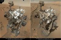
|
Posted by: Phil Stooke May 16 2014, 11:03 PM
Here's a circular version of Damia's sol 631 pan. We might head over the rocky ledge and across that nice smooth depression, but there's another path just behind us in this view with a turn south again that gets past the outcrop more easily.
I will post an updated map on Monday when in my office.
Phil

|
Posted by: neo56 May 17 2014, 09:36 AM
It has not been posted yet on the forum, so here is the panorama taken on sol 620 with MastCam 100mm:
https://www.flickr.com/photos/105035663@N07/14204072125/
http://www.gigapan.com/gigapans/155051
Posted by: wildespace May 18 2014, 10:37 AM
Nothing fancy. Are there any quirks specific to Curiosity I should know about when making these?Try not to have too much separation between red and cyan; human eyes will have a hard time joining them into a single picture. Does your anaglyph software allow to move the images relative to each other? (Personally, I use "Anaglyph Maker" http://www.stereoeye.jp/software/index_e.html )
Concerning depth, parts of the anaglyph where objects overlap exactly will be level with the computer screen. Red objects shifted to the right (and cyan objects shifted to the left) will seem to be in the distance, while red objects shifted to the left (and cyan objects shifted to the right) will seem to be closer to you than the screen. You can use this to make objects seem to stand out from the screen, like the drill tailing in this MAHLI from Sol 627:

|
See it in full-screen, and try to touch different part of the image on your screen.
I wonder if those images could be incorporated into the recent Sol 613 selfie.
Posted by: jvandriel May 18 2014, 01:47 PM
The Navcam Stereo panoramic view on Sol 631.
Jan van Driel

|
Posted by: neo56 May 18 2014, 08:03 PM
I think it's feasible. Shadows are about the same since Windjana pictures have been taken at 12h45 on sol 613 and at 13h15 on sol 627.
It's a good idea since it would show Curiosity with the two drilled holes.
I'll try to make it when I'll have time
Posted by: neo56 May 18 2014, 08:40 PM
Panorama taken on sols 631 and 632 with MC34:
https://www.flickr.com/photos/105035663@N07/14099159310/
Posted by: anticitizen2 May 19 2014, 01:22 PM
I appreciate the advice - just got Anamaker and Hugin. It is difficult compromising between foreground and background object separation, but I'll try not to hurt any more eyeballs in the future. I had just been using the GIMP for everything.
Here is the drive from a few days ago, sol 631, 20 frames
http://i.imgur.com/kRkn0j6.gif
And here is an anaglyph version - Updated
http://i.imgur.com/2n24jIv.gif
Posted by: neo56 May 19 2014, 03:47 PM
http://i.imgur.com/xlJNoqc.gif
Thanks antcitizen2 for this animation, it's really great to see the drives in 3D!
Posted by: Dig May 19 2014, 04:08 PM
A picture that I started a few days ago, but had not been able to finish today.
I like panoramas where Mount Sharp is in the background.
When I finished stitching the panorama of Sol 630, I quickly came to try to include Mount Sharp taken during Sol 610. Though the perspective is slightly different, with some work I managed to blend the two images.
The result is not perfect, but I think it is good enough to share in the forum.
https://flic.kr/p/nojWnG
Click for the full resolution
Posted by: anticitizen2 May 19 2014, 05:30 PM
Thanks Thomas, and excellent combination, Dig! I'm excited to get going, but I'm going to miss Mt Remarkable, I suspect. Good to look ahead to Mt Sharp!
Across the crater we go!
http://imgur.com/a/pmZkq#0
I recommend going fullscreen and using the arrow keys to switch images (let me know if the fullscreen option isn't there for anyone?)
I'm going to keep the image size and separation consistent for my 3D-spins, even if it is less optimal for the very close foreground. I would appreciate any suggestions or input others have, as I'm still new at these.
Making your own buzzing azimuth motor noises is optional, but encouraged.
Edit: Farewell to [the] Kimberley
http://i.imgur.com/LTBiUPw.jpg
http://i.imgur.com/i1UMluH.jpg
Posted by: elakdawalla May 19 2014, 07:04 PM
The sol 634 drive put the Kimberley in the rear-view mirror, so http://www.unmannedspaceflight.com/index.php?showtopic=7845.
Posted by: anticitizen2 May 19 2014, 10:25 PM
The second half of the 631 drive came down.
Updated anaglyph of the first drive segment - http://i.imgur.com/2n24jIv.gif
The view approaching the crater rim:
http://i.imgur.com/YXOcWjG.gif - LNav
http://i.imgur.com/onzBInk.gif - anaglyph minus one corrupted frame
Posted by: neo56 May 21 2014, 08:21 AM
The southernmost outcrop of The Kimberley imaged with MC100:
https://www.flickr.com/photos/105035663@N07/14235718704/
Posted by: CosmicRocker May 22 2014, 06:21 AM
It has been a long time since I have been inclined to use that f-word festoon-word regarding a http://mars.jpl.nasa.gov/msl-raw-images/msss/00631/mcam/0631MR0026080280401658E01_DXXX.jpg
Posted by: jvandriel May 22 2014, 06:46 AM
All the images are down and here is the complete Mastcam L panoramic view
taken on Sol 631.
Jan van Driel

|
Posted by: xflare May 22 2014, 01:54 PM
This has hexagonal veins through it http://www.midnightplanets.com/web/MSL/image/00632/0632MR0026150000401754E01_DXXX.html
Posted by: acastillo May 22 2014, 02:21 PM
Wow! Those look like mud cracks.
Posted by: Beauford May 22 2014, 03:33 PM
I'm a chemist, not a geologist, so what do I know, but this looks like columnar jointing with some kind of subsequent fill. I look forward to some experts chiming in.
Powered by Invision Power Board (http://www.invisionboard.com)
© Invision Power Services (http://www.invisionpower.com)