Printable Version of Topic
Click here to view this topic in its original format
Unmanned Spaceflight.com _ Mars Express & Beagle 2 _ HRSCview
Posted by: elakdawalla Mar 19 2007, 08:50 PM
I just received this press release and didn't see it on ESA's website so thought I'd post it in full here. But first, here's the URL for the new HRSC image viewer:
http://www.geoinf.fu-berlin.de/hrscviewweb/
Have fun, guys!
--Emily
FOR MARS EXPRESS HRSC IMAGES
Press Release: March 19, 2007
Issued By: Gerhard Neukum, HRSC Principal Investigator
The High Resolution Stereo Camera (HRSC) is one of the outstanding experiments on the ESA Mars Express Mission (MEX) (cf. Neukum et al., 2004, ESA SP-1240). MEX has been in orbit about Mars from January 2004. The mission has just been extended until May 2009. By now, the HRSC has covered close to 35% of the surface of Mars in stereo and color at a resolution of between 10 and 20 m/pixel. Much more of Mars has been covered at lesser resolution.
All data are and will be available in preprocessed form up to level 3 through the ESA Planetary Science Archive (PSA) and in parallel through the NASA Planetary Data System. So far, digital terrain models, although produced for the needs of the HRSC Co-Investigator Team from the stereo data, have not been archived with ESA or NASA and have only in exceptional cases been made available to the community at large outside the HRSC Team proper. The reason for that is that the DTMs produced so far are of non-certified, non-archivable quality.
We have received word from the community that generally better and faster access to the data would be appreciated and DTMs as the main asset of the HRSC experiment would be required for scientific needs and mission planning. Therefore, we are undertaking - with substantial support from our national space agency (DLR-Bonn) - the task of reprocessing all data for the derivation of high-resolution certified DTMs that will eventually be archived with ESA and NASA depending on successful negotiations and agreements.
The hi-res DTM production is being done in cooperation between my group at the FU and the Experiment Team under the leadership of Ralf Jaumann at DLR. Also, the need for faster access by the community at large for quick screening of the HRSC image data and some instant manipulation for a rough overview of the assets of the data through computer-based means before going to the ESA or NASA archives for substantial downloading efforts has been expressed to us. The solution we have come to is to establish the following:
HRSCview: Online visualisation of the Mars Express HRSC dataset
A website that provides the ability to explore within the nearly 2 TB of HRSC images is opened for public access thorough a joint website of the Freie Universitaet Berlin and the German Aerospace Center (DLR) at:
http://www.geoinf.fu-berlin.de/hrscviewweb/
HRSCview permits exploration within the images by carrying out on-the-fly data-subsetting, sub-sampling, stretching and compositing, and in the case of perspective views, projection. This means regions of interest can be explored at full resolution without needing to download full data-product sets.
It is possible to view colour and elevation composites with nadir images and select different colour stretches or infra-red channel substitution. It offers perspective views with a choice of viewpoint and exaggeration. The data are explored using Mars surface coordinates, making it simple to move between multiple images of the same location, between adjacent images, and also from a global image-footprint map directly into an HRSC image at a position of interest. The pixel scale of the view can be selected; distance and elevation scale bars are provided.
Images can be accessed by orbit/image number as well as via the footprint map. In either case, a link is provided to a data-product page, where header items describing the full map-projected science data-product are displayed, and a direct link to the archived data-products on the ESA Planetary Science Archive (PSA) is provided.
In general, the elevation composites are derived from the HRSC Preliminary 200m DTMs generated at the German Aerospace Center (DLR), which will not be available as separately downloadable data-products. These DTMs are to be progressively superseded by systematically generated higher resolution archival DTMs, also from DLR, which will be made available for download through the PSA, and be similarly accessible via HRSCview. A number of images which have already been processed in this way are immediately available for visualisation or download via HRSCview.
HRSCview differs from the service provided by the PSA in that it provides a means to explore within the individual (but very large) images, carrying out a preliminary on-the-fly processing of the science data.
HRSCview features:
* nadir, colour composite, elevation composite browsing
* footprint map, with direct navigation into images
* location selection by surface coordinates or orbit number
* perspective views
* direct switching between overlapping images at point of interest
* click off-the-edge of one image to move directly into adjacent coverage
* links to full level-2 and level-3 data-products from product description page
* links to high-resolution level-4 data-products for several images where archive-quality DTMs have been generated
* alternate archive-DTM footprint map
Comments, questions, or suggestions are very welcome, and should be directed to Greg Michael (gregory.michael at fu-berlin.de) and the HRSC Science Coordinator, Stephan van Gasselt (vgasselt at zedat.fu-berlin.de). A poster on the system was presented at the LPSC meeting last week in Houston and will be presented at the EGU conference in Vienna.
Posted by: djellison Mar 19 2007, 09:52 PM
I think we need a code monkey to get to work on the DT4 elevation format and the remaining Level 4 products.
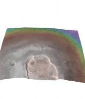
http://www.geoinf.fu-berlin.de/cgi-bin/ion-p?page=product.ion&image=2039_0000
The moment someone can get them converting into some sort of common 3d format....we'll be away.. 720p Anims-a-go-go. The attached is from the Level 3's. It's not really documented so far, but I assume L2 is the radiometric, L3 the map projected and L4 the very juicy elevation and then one presumes the image channels have been projected to fit the elevation model ( as they don't overlay because of the perspective of each channel )
Doug
|
|
Posted by: dilo Mar 19 2007, 10:24 PM
Thanks Emily for this link! 
|

|
Posted by: CosmicRocker Mar 20 2007, 03:55 AM
I just came to post the same email, and am glad to see you folks are already on top of it. What you are already pulling up is pretty impressive. You're way ahead of me.
Posted by: slinted Mar 21 2007, 12:27 AM
This is a very useful tool indeed! It has great linkage between the overview maps and the actual HRSC image products. Also, to our benefit here, you can directly link to an image+position+zoom.
Here's a couple images of the Columbia Hills almost 2 (earth) years apart, showing the effect of changing wind direction on the dark dust devil streaks.
http://www.geoinf.fu-berlin.de/cgi-bin/ion-p?ION__E1=UPDATE%3Aion%3A%2F%2Fhrscview.ion&image=0024_0000&lat=-14.777&lon=175.516&viewport=900x600&zoom=10&mode=nd&scale=25&pview=n&exag=1&UPDATE=Update+view&image0=0024_0000
http://www.geoinf.fu-berlin.de/cgi-bin/ion-p?ION__E1=UPDATE%3Aion%3A%2F%2Fhrscview.ion&image=2271_0000&lat=-14.777&lon=175.516&viewport=900x600&zoom=10&mode=nd&scale=25&pview=n&exag=1&UPDATE=Update+view&image0=2271_0000
Posted by: elakdawalla Mar 21 2007, 01:34 AM
Wow, slinted, great find! 
For those of you who've been following closer than I -- does this change in streak direction happen every Mars year?
--Emily
Posted by: mhoward Mar 21 2007, 02:34 AM

Is it a real change or a lighting difference? If it can't be a lighting difference, it seems like a pretty amazing change.
Posted by: slinted Mar 21 2007, 07:37 AM
With such a dramatic change, lighting differences seem a likely culprit, but I think we are seeing actual surface changes. Here are two images from THEMIS showing similar change in streak direction:
http://themis-data.asu.edu/img/V07909002.html
http://themis-data.asu.edu/img/V16932003.html (12 days before the second HRSC image linked in my previous post)
I am having a hard time finding the answer to your question Emily. In an early http://marsrovers.nasa.gov/gallery/press/spirit/20050819a.html about Spirit's dust devils, there was a mention of 2 dominant directions: southwest-to-northeast in early spiring, northwest-to-southeast in summer, but that doesn't explain the streaks seen in the later images since the neither of these directions align with them.
There is an http://www.lpi.usra.edu/meetings/lpsc2006/pdf/1829.pdf that makes reference to the 'new' wind direction ("...many dust-devil tracks in previous MOC imagery have been erased, replaced with NNW-trending wind streaks indicating winds from SSE"), but does not say if it is a regular, annual shift.
edit: I should qualify the streaks as being wind streaks, and not necessarily dust devil tracks. The features seen in the 10/05 images are so broad that it's not clear that dust devils are directly responsible. For a better understanding of the processes involved, see Greeley's http://europa.la.asu.edu/pgg/associates/members/williams/gw/pdf/2005GABCFHKLNNSSTWW.pdf which includes an analysis of the 2004-01-16 HRSC image.
Posted by: slinted Mar 22 2007, 01:41 PM
After a little more hunting, I found two wide angle MOC images that show exactly when the newer N-S streaks were formed. http://www.msss.com/moc_gallery/r22_s04/images/S04/S0400238.html was taken on March 5th, 2005 and http://www.msss.com/moc_gallery/r22_s04/images/S04/S0400558.html was taken on March 12th, 2005. The difference between the two images is dramatic given the short amount of time between them but what is even more shocking with regards to Spirit are the equivalent sols: 416 - 423. Much to my surprise, the formation of these N-S streaks corresponds to Spirit's first and most significant http://marsrovers.jpl.nasa.gov/gallery/press/spirit/20050323a.html, as well as the http://marsrovers.jpl.nasa.gov/gallery/press/spirit/20050314a.html sighting! 

http://www.lyle.org/~markoff/collections/S0400238_S0400558.gif
Posted by: ustrax Mar 22 2007, 02:04 PM
slinted...you have made a GREAT work!!!
Posted by: MarsIsImportant Mar 22 2007, 02:57 PM
Wow!
It's pretty clear in my mind that these are real surface changes. Lighting differences don't account for all the changes.
Posted by: CosmicRocker Mar 23 2007, 05:49 AM
Whoa! I don't think I fully appreciated the implications of your discovery when I first scanned this thread, slinted. I can't imagine that this is an effect of different lighting conditions. This must be a local, but quite large event that occurred some time within a 7 day window. The apparent correlations to the cleaning event and the first DD of the season really makes one pause to consider. Great work!
Posted by: CosmicRocker Mar 24 2007, 05:36 AM
Emily: That was a very nicely done blog entry on this topic today. I'm surprised this hasn't generated more discussion here. I think Dan's detective work is one of the best examples of I've seen of a space "enthusiast" making a significant scientific observation with publiclly available data.
Posted by: Steve Mar 24 2007, 05:56 PM
What surprised me is that when I checked the individual images, rather than the blink, the dark streak was in the later image, but there was a faint dark streak in the same place in the earlier image. Are we looking at the cleaning off of a light dust cover or is this the deposit of a second streak in the same place?
The second point is that the dark streak (or streaks if this is a generation of a new one rather than cleaning of an old one) begins at a crater. I seem to recall that many of the dust devil tracks in the early satellite images of Gusev began at craters and, of course, we've seen the streaks downwind of Victoria.
Can anyone hazard an informed guess of what's going on here?
Steve
Posted by: elakdawalla Mar 24 2007, 06:29 PM
My very basic understanding is that the dark stuff isn't "deposits," it's just areas of disturbed soil. That's why rover track marks start out dark too. Wind streks tend to start at crater rims because regional winds blowing over bits of topography generate turbulence that can kick up dust (and apparently, sometimes, dust devils). It wouldn't be a huge surprise to me to see some paleo-indication of a wind streak in the same area -- all you need is a wind coming from the same direction, acting on the same local topographic features. The question is then, what suddenly made this strong wind coming from the south-southeast?
--Emily
Posted by: ustrax May 21 2007, 10:16 AM
Some Deuteronilus Mensae http://www.esa.int/esaSC/SEMBS5V681F_index_1.html#subhead5...
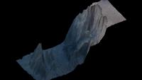
Posted by: djellison Jan 1 2008, 04:41 PM
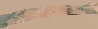
At the HRSCView site, they now have a downloadable IDL VM tool - and if you download the complete set of level 4's for an observation, you can do some primative processing yourself.
It includes a perspective viewer - which can do things like the attached. It has an export-to-vrml option, but the VRML's it produces are enormous files that no application I can find can use.
If only...if only I could get these HRSC DEM's into 3ds max 
Doug
|
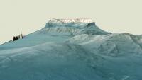
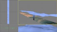
Posted by: djellison Jan 4 2008, 11:22 PM
Lady's and Gentlemen....bingo.
Emily was kind enough to put me in touch with Greg Michael who, within 24 hours, had an IDL script on the HRSCView website ( http://hrscview.fu-berlin.de/software.html - bottom of ) to export 8 bit tif's of all the imaging channels, and a 16bit tif of the DEM.
As a result - the attached out of 3ds max. And yes - a movie is rendering right now 720p, it'll be done by the end of tomorrow.
Doug
|
|
|
Posted by: lyford Jan 5 2008, 12:32 AM
Um, OMG?!?!?!? 
It's like UMSF is a massively parallel networked system a la SETI@home, except instead of sharing CPU cycles it channels "enthusiast resources" to create TEH MOST AWESOMEST IMAGERY EVER!!!*
I am so glad to be part of this board...
*If you can't take the hint, this was supposed to get you to post the movie, Doug. 
Posted by: Stu Jan 5 2008, 08:08 AM
Wow Doug, I genuinely felt a shiver run up my spine when I saw those images... this is the kind of breakthrough that really could help to show non space- and Mars-enthusiasts that Mars is a real world, with alien but strangely-familiar landscapes. When I highlighted those "MRO perspective views" a few days ago I fully expected someone to post a "They look great, but actually they are vertically exaggerated" reply, because they just look 'wrong' to me somehow (I'm sure they're not, it's just me!) but those images of yours look like the view through a spacecraft window... just stunning... thank you! I can't wait to see how this evolves.
We may just have found the door to a martian Narnia...
Posted by: djellison Jan 5 2008, 01:34 PM
Not sure on the vert exag myself with these yet. Thing is - the really big features (like Oly Mons) look crap without vertical exaggeration.
I'll try and do something to explain how I'm doing them - but I actually end up with two noodles for the data. One is a low res version which I actually have in 3d in 3ds max, maybe 200 x 1000 polygons, displaced by the elevation tif.
Then, there is a flat surface, which is also displaced by the tif, but in the rendering process - at it's full res, so it emulates the full res of the tif, maybe 8 million points ( 1000 x 8000 for example ).
To have the 8 million polys in real time would be murder to animate - so I drop a blank blue texture on my low res version and put it directly on top of the 'real' one. I keep increasing the displacement of the low res one until it matches (as they're displaced using different techniques they don't work exactly the same) - by rendering and re-rendering until the high res displacement, and the low res blue just about match.
THEN - I can set the blue to be none-rendered, but use it as a guide for animating the camera over.
As a result, I'm not entirely sure of the vertical elevation I'm getting. What I'll have to do is make a simple box with the length, width, and total height of the terrain from highest to lowest point - and then fit the other two to match it. I think.
Doug
|
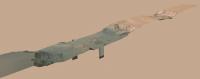
Posted by: djellison Jan 5 2008, 03:00 PM
Low res ( 3 meg) and High Res ( 9 meg ) available here
http://www.rlproject.com/HRSC/2039
H264 Quicktimes - the low res should play on anything, the high res, you might need a bit of grunt.
FYI - the render of 500 frames took 3hrs 20 mins on a Quad Core 3Ghz machine with 4 Gig of Ram running Win XP 64.
Doug
Posted by: RJG Jan 5 2008, 03:23 PM
Great stuff, Doug! The hi res runs perfectly on my fairly modest desktop so shouldn't be a problem for most.
Pity the strip is so narrow, seeing the edges takes away some of the feeling of 'immersion' (unless there is some way for me to zoom in with my viewer). Are you planning any other (ie not straight down the middle) fly-throughs? (*Not* wishing to sound ungrateful -just that you've whetted my appetite for more!)
This really is tremendous - thanks for sharing!
Rob
Posted by: djellison Jan 5 2008, 03:49 PM
That's the challenge, the data is taken in ribbons (push broom) and thus that's one observation.
I'm currently working on putting two observations in a mosaic ( by doing a mosaic of the imagery first, then simply having one terrain object in 3ds max ) which will, instead of being something like 10,000 pixels long and a 1000 across, be more like 3000 across and 6000 long (380_0001 and 420_0001)
They will always have the feel of looking 'at' a product rather than being in it - simply because it will fall apart if the camera is too close (low resolution).
Doug
Posted by: climber Jan 5 2008, 09:28 PM
Whouaouh ! Father Christmass is late, but what a present !
Thanks Doug
Posted by: OWW Jan 5 2008, 11:56 PM
Here's an idea: Put the camera right on the edge of a cliff and let the camera pan around into the valley like the viewer in Midnight Mars Browser. That should be spectacular, and I'm guessing the camera will still be far away enough from the valley floor...
Posted by: nprev Jan 6 2008, 12:02 AM
The high-res didn't work for me (got a plug-in error), but the low-res did...and that was enough. Damn!
Thanks, Doug; a very nice gift to us all!
Posted by: djellison Jan 6 2008, 12:22 AM
Hmm - what you using to play it? You'll need the latest quicktime. (Although VLC might do it) Save it to your desktop and run it from there, don't ask a browser to play it.
Two more tomorrow. One a bit 'soft' on the terrain (a mosaic with the stitching done with the imagery) and a double for Val-Mer (a mosaic of two with the stitching done with the geometry). The problem with MEX is that it really REALLY doesn't orbit at a standard time of day, so no two neigbour noodles will match up at all - even if you tweak all day. In one case, I've got thick fog in Val-Mer, and the stitch has thing fog. A bit hard to handle really.
Doug
Powered by Invision Power Board (http://www.invisionboard.com)
© Invision Power Services (http://www.invisionpower.com)