Printable Version of Topic
Click here to view this topic in its original format
Unmanned Spaceflight.com _ Dawn _ Ceres High Altitude Mapping Orbit (HAMO)
Posted by: Holder of the Two Leashes Aug 17 2015, 01:42 AM
DAWN arrived in its new lower mapping orbit on August 13th. The DAWN team is preparing to resume science observation tomorrow on the 17th.
From the Current Mission Status page at the DAWN website:
Dawn completed the maneuvering to reach its third mapping orbit and stopped ion-thrusting this afternoon. This was a little ahead of schedule because the spiral descent went so well that some of the allocated thrusting time was not needed. Since July 14, the spacecraft has reduced its orbital altitude from 2,700 miles (4,400 kilometers) to approximately 915 miles (1,470 kilometers). The orbit period has correspondingly decreased from 3.1 days to 19 hours.
Dawn is scheduled to begin its new observations on the evening of Aug. 17 (PDT) and continue for more than two months. First, however, the mission control team will measure the actual orbit parameters accurately and transmit them to the spacecraft.
Posted by: Steve5304 Aug 17 2015, 01:57 AM
Cant wait to see spot 5
Posted by: Habukaz Aug 22 2015, 09:57 AM
In the http://dawnblog.jpl.nasa.gov/2015/08/21/dawn-journal-august-21/ it is mentioned that pictures and other data from HAMO have started arriving on Earth, so it shouldn't be that long now before we get a look.
Nothing at all negative about the image release policy, but I have long since got bored of seeing the same terrain with the same resolution from a slightly different angle.  (HAMO and LAMO are of course more promising in this regard)
Posted by: RotoSequence Aug 25 2015, 02:13 PM
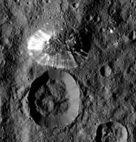
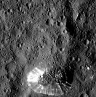
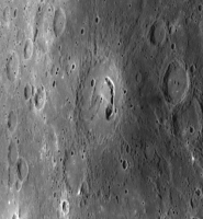
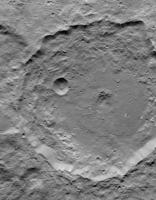
The first three HAMO images have been released: http://www.nasa.gov/jpl/pia19631/the-lonely-mountain
Posted by: Steve G Aug 25 2015, 02:37 PM
For a world that we expected to have slushy ice, that sure looks like a rocky surface. I was expecting a Calisto kind of look but that sure looks like the Lunar surface to my untrained eye.
Posted by: FOV Aug 25 2015, 02:59 PM
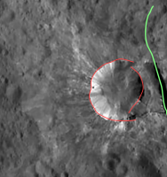
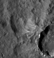
Cropped Ceres mountain image from today's release. Again the albedo variances creating a saturation/glare effect. To me it looks like the bright material could be deposited from several vents found on both the mountaintop and flanks.
|
Posted by: alk3997 Aug 25 2015, 03:30 PM

It is interesting that within the bright streaks there does not appear to be any craters, even though outside of the immediate area there is a good small crater population.
Whatever is going-on must be a very localized event, at least on the surface.
Andy
Posted by: Habukaz Aug 25 2015, 03:42 PM
Consistently in the three images, slopes (whether on mountains or crater walls) have few to none craters. This is presumably due to mass-wasting, relaxation or similar. I believe this is the norm on celestial bodies.
The summit itself looks like it could be cratered, but several shapes certainly look elongated.
Posted by: TheAnt Aug 25 2015, 04:10 PM
Yes there's craters on top, and that area looks as old as the surrounding terrain that IMO gives the impression that the mountain have been created by a force from below. In short, that it is a pingu or created in one somewhat similar process.
Posted by: Charles Aug 25 2015, 04:39 PM
If I have my compass bearings right, it's now clear that the North, West and East slopes of the mountain are not only "shiny" but craterless in contrast to the Southern slopes (partly in shadow) and plateau which appear heavily cratered. Presumably young versus old. Along the Western slope there is a circumferential discontinuity about halfway down, broken by a thick ridge that appears to have a splash of debris at the bottom. There appear to be two or three bright spots on the plateau, far from the slopes, and one partway down the cratered slope on the Eastern side.
I can't wait to read speculation on all this. What's going on?
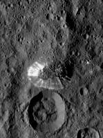
Posted by: atomoid Aug 25 2015, 10:28 PM
yes, its all too fascinating.. it really looks like some sort of plug thrust up pingo-style, slowly covering the surface outward as it grew, with one side becoming too steep and wasting down to erase craters and reveal underlying brighter material.
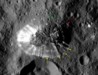
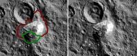
Many craters appear to have been gently lifted up along with the mountain surface (green arrows) a few of those higher up the incline appear to have been elongated by slippage.
Some landslide splashing out across the floor at the foot of the mountain (yellow arrows).
Apparent large mass-wasting event on shadowed side perhaps was too slow to disturb its surface. hard to say whether the splash smudge at the bottom post-dates that event (red arrow).
|
Posted by: Steve5304 Aug 25 2015, 10:45 PM
Many craters appear to have been gently lifted up along with the mountain surface (green arrows) a few of those higher up the incline appear to have been elongated by slippage.
Some landslide splashing out across the floor at the foot of the mountain (yellow arrows).
Apparent large mass-wasting event on shadowed side perhaps was too slow to disturb its surface. hard to say whether the splash smudge at the bottom post-dates that event (red arrow).
|
|
I see less of a indigenous mountain...more like a snowball hitting a wall. Thoughts?
Posted by: Bill Harris Aug 26 2015, 01:38 AM
http://photojournal.jpl.nasa.gov/catalog/PIA19631
Whoa. It's the Big Rock Candy Mountain. THE most primo example of pareidolia I've seen in a while.
Subsequent HAMO and LAMO images ought to be interesting...
--Bill
Posted by: Explorer1 Aug 26 2015, 02:49 AM
Imagine the surface view on that tiny flat strip between the base of the mountain and the crater rim. A big hole right next to a enormous mound; what a bizarre little world!
Posted by: nprev Aug 26 2015, 03:02 AM
Absolutely bizarre. Note also the large landslide of dark material on the top edge of the crater immediately adjacent to the mountain.
Haven't got a clue what's happening here.
Posted by: Yadgar Aug 26 2015, 08:51 AM
Hi(gh)!
Is it just me or does the mountain in fact look like an exact negative of the crater, rotated by 90 degrees?
See you in Khyberspace!
Yadgar
Posted by: hendric Aug 26 2015, 09:55 PM
If it was a pingo, how did it end up starting there instead of inside the (presumably) weaker crater floor to the south? It does look like it is at the intersection of a couple of valleys, so maybe those allowed deeper cracks to reach down, far enough away from the crater? I am not 100% on the crater being older than the mountain - the slopes on both show no craters, and interior of both don't qualitatively seem much different.
The horizontal banding on the slopes is what surprises me. Are those real layers or some kind of side effect of a talus at angle of repose? In either case, none of the nearby craters have horizontal banding, just typical vertical mass-wasting bands.
Definitely a head scratcher!
Posted by: HSchirmer Aug 26 2015, 10:04 PM
Is it just me or does the mountain in fact look like an exact negative of the crater, rotated by 90 degrees?
See you in Khyberspace!
Yadgar
Yes, I noticed the same thing.
The "Lonely Mountain" bears a striking resemblance to the adjacent crater.
It looks like a giant golf divot.
Posted by: antipode Aug 26 2015, 10:36 PM
I wonder if high resolution mapping might not eventually find more of these 'things', albeit at smaller scale.
It would be very strange if there truly was only 1.
P
Posted by: Habukaz Aug 27 2015, 09:59 AM
That, or older ones that have been eroded almost beyond recognition. I can only imagine that a direct hit on a feature like that with a sizeable impactor could do some serious damage (or destroy it completely).
Posted by: Bill Harris Aug 27 2015, 10:03 AM
Yess!!! That is a good decriptor-- the closer we look, the odder it looks back at us. As I have noted with some of the Rosetta-features, it looks almost M.C. Escher-esque.

My preliminary take on it is that it is a "mud volcano", a deposit driven by a hydrothermal vent composed of entrained detritus and residual salts. And much akin to the Occator Spot5, and the other large spots and the many many small spots scattered about. These spots will prove to be a major feature (and enigma) of Ceres.
Note, for example, the "small' 2000-meter diameter light-toned spot about 13000 meters to the southwest (to the right on the image-view) of "Tall Mtn". It was barely noticeable on the Survey Orbit images but is somewhat prominent on the initial HAMO image and who knows about future views.
--Bill
Posted by: Habukaz Aug 27 2015, 10:27 AM
By the way, I just realised that http://photojournal.jpl.nasa.gov/catalog/PIA19633 is similar in size (84 km) to Occator (90 km), so to get an idea of what Occator will look like to us shortly, take a look at the image of Gaue.
As far as I can see, we've also been https://twitter.com/NASA_Dawn/status/636631390197420032 a fresh HAMO image later today.
Posted by: HSchirmer Aug 27 2015, 01:06 PM
It still looks like a golf divot.
"Dantu's divot. An antipodal shock feature."
Ever seen an elliptical water-drop-basin? You let a drop of water fall at one focus, the ripples spread and reflect,
the reflections converge, and a drop of water jumps up from the other focus.
Mimas has a huge crater, and at the other side the crust is broken up by a series of cracks and chasms.
If you think back to Vesta, there is some interesting topography http://beyondearthlyskies.blogspot.com/2013/10/shockwaves-from-rheasilvia-impact.html and a few peer reviewed papers. Image of Vesta below.
Basically, at Vesta, the antipodal area is uplifted with a (probably) later crater at the focus and a "splat" area where craters are missing or disrupted.
At Ceres, Lonely Mountain is just about antipodal to Dantu crater. The antipodal area has valleys/faults, a crater, and the Lonely Mountain.
Situation is bizarre; looks as if a chunk of crust poped out, settled back to the surface, followed by weathering to create smooth talus slopes.
|
|
Posted by: hendric Aug 27 2015, 03:56 PM
Ice I surprised me at being stable to near gigapascal pressures when I checked, so I suppose it is possible that as a Cerean mantle/ocean freezed out, the pressure underground caused/causes water volcanism, or ice extrusion, or crustal tilting of large blocks like this. That's what I was just thinking, that it looks like a portion of crust has been pushed out along a couple of fracture lines.
I can buy a lack of cryovolcanic features on Ceres based on not having enough energy when the crust was thin, and now that the crust has thickened any water freezes before reaching the surface, pushing up on this block, similar to the dome at Mount St. Helens. (neat time lapse at https://www.youtube.com/watch?v=h6B1myUKAS4 ) The wrinkle is the singular rarity of this mountain - was this the weakest spot on the crust, and the pressure from beneath isn't high enough to push any where else?
With the layers visible in the slopes, I wonder if those are not typical angle-of-repose talus slopes, but slopes caused by sublimation off the original cliffs as they extruded, similar to the Grand Canyon with sunlight instead of water acting as the erosive force? With the original crust acting as a protective "cap" on the top. Except I would expect the south side (closest to the crater) to be less eroded. (scratch scratch)
Someone care to guess the volume of the Lonely Mountain? (I keep hearing dwarven singing!)
Posted by: Habukaz Aug 27 2015, 04:06 PM
Ooo, look at that: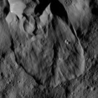
Something happened here.  (and not very long ago)
http://photojournal.jpl.nasa.gov/catalog/PIA19635
Posted by: Habukaz Aug 27 2015, 04:54 PM
After searching a bit, it seems almost certainly to be an area featured in Survey images http://photojournal.jpl.nasa.gov/catalog/PIA19581, http://photojournal.jpl.nasa.gov/catalog/PIA19592 and http://photojournal.jpl.nasa.gov/catalog/PIA19593.
Seems like a regular landslide related to a crater sitting on the rim of a much larger crater: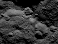
Posted by: HSchirmer Aug 27 2015, 05:06 PM
(snip)
That's what I was just thinking, that it looks like a portion of crust has been pushed out along a couple of fracture lines.
Yep, found the correct term = "hertzian cone". When a piece of glass is shot by a bb-gun, you get a conical hole and a conical chip.
The shiny sides make the mountain look like a conical chip that was knocked off, flipped over, and landed beside the hole.
Posted by: Herobrine Aug 27 2015, 05:18 PM
I'm looking forward to our first look at Occator from HAMO. In July, I put together this preview of what we can expect in terms of Occator size at HAMO and LAMO in Framing Camera imagery.
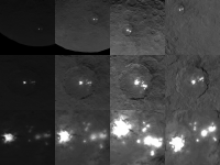
|
Note: That image is 1/4 actual resolution (each frame is shown at 256x256 instead of 1024x1024)
LAMO is going to be mind-blowing; the area of the spots will fill the entire frame.

In case it isn't obvious, the top row contains images from the second mapping orbit; the middle row contains simulated views from HAMO; the bottom row contains simulated views from LAMO.
Edit: Updated the image, adding the most recently published survey orbit image of Occator (as long as I'm reposting, I might as well update/improve it).
Posted by: Bill Harris Aug 27 2015, 05:38 PM
Yes. This relates to a very common Cerean feature, what I informally call a "flowage" or "slippage", for lack of an equivalent terrestrial analog. This has been seen in the SO images where a large (on the order of hundreds of Km) of the surface slip and flow in a fluidic manner. This occurs "internal" to craters as well as "external" to craters, and seems different than simple mass-wasting (although there are similarities).
This particular feature in HA-4 is on the order of 15-20 Km is size, which by terrestrial standards would be a continental catastrophe.
Tighten your seatbelts. This is only the fourth HAMO image...

--Bill
Posted by: Daniele_bianchino_Italy Aug 27 2015, 09:22 PM
Probably my eyes but resemble a cone ;-)
Posted by: MarsInMyLifetime Aug 27 2015, 09:50 PM
If the sunlight is from the right of this picture, then there is a peak with its shadow projected to the left. And it appears to have a small crater right at its peak. There may be more to find now that we have good enough resolution for this scale of object.
Edit: But now that I found where this clip came from, I see that it sits inside a depression and the slope is more "hummocky" than "conical." Its formation may have been fairly unexceptional.
Posted by: MarsInMyLifetime Aug 27 2015, 09:59 PM
Just a short distance to the 1:00 position of this mountain is a linear object. I took it to be a dike or scarp at first, but it almost has a platey appearance as if it were being thrust up. If this is in fact a pointy plate, the upthrust mechanism could be similar to what has lifted the regolith-covered peak of what I like calling Little Prince's volcano."
|
Posted by: antipode Aug 28 2015, 03:13 AM
Well spotted! Yeah that looks suspiciously related.
I also wonder if the top of the mountain really is exactly like the clearly ancient terrain that surrounds it.
It looks different to me - although possibly its just some kind of mass wasting...
P
Posted by: Daniele_bianchino_Italy Aug 28 2015, 09:06 AM
Edit: But now that I found where this clip came from, I see that it sits inside a depression and the slope is more "hummocky" than "conical." Its formation may have been fairly unexceptional.
Many Thanks for your explain
Posted by: Bill Harris Aug 28 2015, 09:45 AM
Three views, and musings, of "Tall Mountain", Ceres
Exaggerated View
https://univ.smugmug.com/Dawn-Mission/Ceres/i-6tDRc9d/0/L/PIA19578--SO-10--crop3--exagg3x--enh4--ref-L.png
Relief and Elevation Maps
https://univ.smugmug.com/Dawn-Mission/Ceres/i-QxXfq7H/0/L/Tall_Mtn--crop--PIA19625--cyl_map-names--invert--annot-L.png
First HAMO image
https://univ.smugmug.com/Dawn-Mission/Ceres/i-P5WVvw7/0/L/PIA19631--HO-1--orient-N--enh1-L.png
--Bill
Posted by: Daniele_bianchino_Italy Aug 28 2015, 10:36 AM
often, when I see these things in the Italy seas I think at the mountain of Ceres, I'm serious...
This not a speculation, obviously Cererean Mount is a geological structure.
Daniele
|
Posted by: Habukaz Aug 28 2015, 01:17 PM
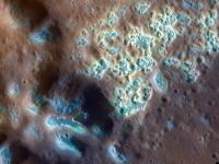
Two news articles from MPS and DLR:
http://dlr.de/dlr/en/desktopdefault.aspx/tabid-10081/151_read-14725/#/gallery/20333
http://www.mps.mpg.de/4087934/news_publication_9379333?c=6775
Posted by: ZLD Aug 28 2015, 03:15 PM
Thanks for those Habukaz.
It is especially intriguing that the plateau would have a surface in similar appearance to the much lower surrounding ground, while the sides are so smooth. Even more so if it is a result of some sort of fault uplift with the lack of a large amount of distortion.
It almost seems like the surface became extremely elastic when the impact occurred. Such as the case where you push on a water bed, the nearby ground was forced upward. This would require some liquid or something very near the liquid state to be heated during impact, for this to occur however.
Here's a cropped and enlarged version of the area with a little more processing.
|
Something else I hadn't noticed previously is the small debris(?) pile at the bottom of the mound near the 5:00 position. Seems to be the only one like it. The linear feature that extends above it also seems to extend away from the average slope as well.
Edit: Also, here's an enlargement of the HAMO 4 image as well.
http://i.imgur.com/pRZs3PN.png
(click to enlarge)
Most interesting to note here is the... smudgyness of the features extending northward (or towards the top of the image) from the uppermost large crater. Deep fault line maybe?
Posted by: Bill Harris Aug 28 2015, 03:36 PM
Digging out the soil mechanics and slope failure analysis reference books and hitting the 'Net for a bit of library work. Do we know of references for slope stability and/or angle of repose for low-gravity atmosphereless worlds? In the classical refs, all I can come up with for gravity is the tie-in to density, and an atmospheric/moisture effect for interparticle friction/internal friction. I'm looking for ways to analyze these "flowages" and "slumpages" that we see on Ceres. And I keep coming up with wet, liquid-y flow processes and I'm looking for alternative views.
BTW, the angle of repose for "Tall Mtn" is 2.5-3:1, which might be reasonable for a granular material in terrestrial conditions. FWIW.
--Bill
Posted by: Habukaz Aug 28 2015, 04:09 PM
The strange feature close to a crater from Survey orbit is back, and it still looks pretty weird to me:
http://photojournal.jpl.nasa.gov/catalog/PIA19881
(just like the apparent landslide, it also features in Survey images http://photojournal.jpl.nasa.gov/catalog/PIA19581, http://photojournal.jpl.nasa.gov/catalog/PIA19592 and http://photojournal.jpl.nasa.gov/catalog/PIA19593)
Nice catch, I also see it. I think there might be smaller versions of it around, though (both the ridge (it casts a shadow) above and the 'pile' itself).
Posted by: ZLD Aug 28 2015, 04:33 PM
Here's an enlargement of HAMO 5.
http://i.imgur.com/sRrIUtm.png
(click to enlarge)
The feature definitely continues to look strange. If the white material here was just slightly under a dusting of the grey material, why aren't we seeing it where this more rectangular edge is located? As I recall from the animations I did of this spot from the survey orbit images, the crater just south of of the rayed crater, is another uplifted mound with a large crater at the top. The craters with the white flecks always seem to have very sharply definitely edges and steep walls. I'll be very interested to see Spot 1.
Here's that animation once more:
http://i.imgur.com/wW0fJ5r.gif
(click to animate)
Posted by: Charles Aug 28 2015, 05:31 PM
https://univ.smugmug.com/Dawn-Mission/Ceres/i-P5WVvw7/0/L/PIA19631--HO-1--orient-N--enh1-L.png
--Bill
Let me go out on a limb on the lonely mountain. If this is an uplifted feature, I've been puzzled by the lack of debris around the base.
Now that I'm looking more carefully, I see relatively fewer small craters around the base to the North and East (12-4 o'clock), especially between the mountain and the crater (12-2 o'clock). There is obvious flow INTO the crater (11 o'clock). And to the Northwest and West, perhaps what looks like a splash or flow (11-9 o'clock).
What if the Northeastern half of the mountain lifted first? The ice (?) interior was exposed as the regolith sloughed off. By this interpretation, the Southwestern quarter of the mountain has uplifted more recently, carrying its cratered surface with it. The regolith has not yet sloughed away. I see no sign of debris flow (yet) there, around the base of the mountain (~9-4 o'clock).
Alternatively, the lonely mountain results from a single uplift event, but for whatever reason the rake of the NE half was steeper -- causing the powdered regolith to slough away there.
|
Posted by: ZLD Aug 28 2015, 06:07 PM
Looking at the crater with the shelf, I think the strange feature could be a very large slump.
|
In red is a rough outline of the crater wall. If it slumped forward and down I think it could result in what we see here. In green is entirely a speculative fault line that isn't apparent in any images yet returned.
Posted by: Bill Harris Aug 28 2015, 06:27 PM
...and why the unusual thin-and-splashy light-toned rays?
--Bill
EDIT= That is not Haulani. Look at pia19595 (SO-27)-- this unnamed "slump" crater is in the upper left edge and Haulani Crater is near the lower right edge. SO-27 is not oriented with North perfectly "up"-- it is a NNW track betw Haulani and this unnamed crater. And to further confabulate things, Haulani crater has it's own fine set of sparklies.
--Bill
Posted by: ZLD Aug 28 2015, 07:22 PM
Whoops, wasn't sure on the name of this crater and just took a guess. Thanks for the correction.
The rays wouldn't be related to the slump necessarily. Those could be from an impact blowing them outward followed by the slumping of the side of the crater inward after a quake at a nearby fault line or just because of uneven heating of the ground.
In this higher resolution image from HAMO, it looks very similar Haulani (I think previously Spot 1?) with the pattern of white material. In previous images theres a bit of evidence in my opinion, to show that Haulani is the remnant of a caldera and the white material is from sputtering magma outward. In this 'slump' or 'shelf' crater, it could be from a similar event. Possibly a single ejection event occurred and when the magma chamber emptied, it left a cavity that was partially filled by the slumped edge.
Posted by: Bill Harris Aug 29 2015, 12:29 AM
No problemo-- it's hard to tell who the players are. And on the "current best Ceres map" that area is near where the resolution goes from good to less-than-good and it's hard to tell. It may be some time before the maps get updated with all of the SO imagery.
I have most ("selected") of the SO images with added Feature and Annotation Overlays where I can outline the "slumpages and flowages" and Faculae (bright spots) and a couple of flavors of Lineations and plan to use the Survey images as an Index for the more detailed HAMO and LAMO imagery.
--Bill
Posted by: hendric Aug 29 2015, 12:36 AM
The lighting is really screwing with my head. Does anyone else see the double crater in HAMO4 as a caldera, a la Olympus Mons? I get a feeling that there was a pyroclastic flow to the NW that etched the ground, giving it those lineations and making that area fuzzy.
Posted by: Bill Harris Aug 29 2015, 01:24 AM
Yes, I have been thinking that many of these craters look quite un-impactlike. This takes us back to the early days of Lunar exploration where there was a vigorous debate on the Impact or Volcanic origin of craters.
And on the Second Day of HAMO...
--Bill
Posted by: dvandorn Aug 29 2015, 01:33 AM
Bill, you posted that exactly as I was bringing the thread up to post the same thing. These craters may be impact-formed, but if so, the target material has far different properties from what we've seen on rocky worlds, and also far different from what we've seen on icy worlds farther out from the Sun. Some of these flows look more like they were blurped onto the surface, not thrown as ejecta or erupted as volcanic units. More like a they were vomited onto the surface.
I wonder how much difference it makes that Ceres is too close to the Sun for the exposed ices to completely resist sublimation, yet too far from the Sun for a world with so much water to be primarily rocky. We're in a different thermal environment for a watery world than we've seen before. Perhaps that's what is driving the strangeness we're seeing in the surface features.
-the other Doug
Posted by: JohnVV Aug 29 2015, 01:39 AM
on that image ... No
normally if the shadows are UP or on the RIGHT the brain sees craters
if the shadow is DOWN or on the LEFT people see mounds
http://imgbox.com/cdsOj2RI
Posted by: Bill Harris Aug 29 2015, 02:08 AM
For sure, Doug. This world is going to be driving planetologists bonkers for years to come. I was hesitant to stir the pot again and suggest impact or non-impact, but I kept wondering if this or that feature is a cradera or a calter.
I'm almost giddy awaiting higher rez images of the Occator Fluctae (to get in step with proper terminology)...
--Bill
ADDED: In reflection, one thing we have learnt with Comet 67P/C-G is that crater-like structures are not always caused by impact. These active pits or vents are sublimation-related features where the icy material in warmed, loses it's volatile "cementation" and erodes in a circular manner with increasing depth. An icy world like Ceres formed near the frost line would be much more prone to this than our Moon, which by virtue of it's formation process was devolatilized, or other small bodies, like Vesta, which are rocky.
--b
Posted by: TheAnt Aug 29 2015, 11:10 AM
@MarsInMyLifetime: The "Little Prince's volcano." Cute name for the mountain. That's why I am advocating that this feature be named Saint-Exupéry, even though it seem less likely that it might be an actual volcano.
Now that I'm looking more carefully, I see relatively fewer small craters around the base to the North and East (12-4 o'clock), especially between the mountain and the crater (12-2 o'clock). There is obvious flow INTO the crater (11 o'clock). And to the Northwest and West, perhaps what looks like a splash or flow (11-9 o'clock).
What if the Northeastern half of the mountain lifted first? The ice (?) interior was exposed as the regolith sloughed off. By this interpretation, the Southwestern quarter of the mountain has uplifted more recently, carrying its cratered surface with it. The regolith has not yet sloughed away. I see no sign of debris flow (yet) there, around the base of the mountain (~9-4 o'clock)....
Yes I also noted that there's craters on part of the mountain slope, but not on the other sides, so yes also I wondered if it might one unusual pingu like iceplug that first tilted up on one side, and then on the other to give that appearance.
But since I am unable to even find a speculation why it should behave that way I left that idea rest here, until you now mentioned it.
So yes it's a possibility, but until someone can come up with a example of such a stepwise behaviour I will go with the idea that it is a single event that created the mountain and that we simply see crust material that happened to stick together in those positions.
I agree it is odd, unless the white material is salts, and the crack happened to contain a splinter of ice brought closer to the surface by the impact that sublimated afterwards. (This means that that crater could have more ice on adjacent sides that simply happened to have more ice that just got it lucky by being covered by more regolith / asteroid dust material - only said as one possible solution to what we're seeing here.)
Posted by: HSchirmer Aug 29 2015, 01:37 PM
These active pits or vents are sublimation-related features where the icy material in warmed, loses it's volatile "cementation" and erodes in a circular manner with increasing depth.
Actually, the best analog for Ceres may be Mercury. Both have surface material near the melting/sublimation point.
Some of the Mercurian crater pits share features with Cere's odd craters,
http://messenger.jhuapl.edu/gallery/sciencePhotos/pics/CN0162741014M_RA_3_web.png
And consider the stunning images of Mercury's "hollows"
http://news.nationalgeographic.com/news/2011/09/110929-mercury-nasa-messenger-new-hollows-sulfur-space-science/
Then compare those to Habukaz's croped image of the crater-
|
|
Posted by: Steve5304 Aug 29 2015, 01:59 PM
Maybe lonely mountain is an ice spike. We know ceres has liquid/slosh water below. An impactor.comes in and hits a spring and exposes it to the vacuum and low gravity of space and it freezes into this big ice mountain which is shaped so strange on its sides it has to be ice. I see lots of evidence of temporary flows on the surface and they are all adjancent to larger impactors.
https://en.m.wikipedia.org/wiki/Ice_spike
Posted by: Bill Harris Aug 30 2015, 01:59 AM
One good reference to refresh the impact vs volcanic discussion is The Measure of the Moon, by Ralph B. Baldwin. This is one of the seminal works in planetology which shifted thought towards lunar impact processes on the 1960's and influenced views on other planets. Although Baldwin was an impact advocate, he does present both sides of the debate. It's just hard to find a volcanic crater advocate nowadays.
A review of the book of you have a Science Mag account:
http://www.sciencemag.org/content/140/3565/374.1.citation
No e-book available, but here is the Google Books page:
https://books.google.com/books/about/The_Measure_of_the_Moon.html?id=LZMHAgAACAAJ
Ceres will prove to be a worthwhile world and will bring about some major changes in thought about impact processes.
--Bill
Posted by: dvandorn Aug 30 2015, 04:00 AM
Yes -- Both Spudis and Wilhelms (two of my favorite lunar science authors) give kudos to Baldwin. And wasn't it Baldwin who, after holding stubbornly to other theories for a time, finally pronounced Barringer Crater an impact feature?
I completely agree, Baldwin is seminal for impact theory. And much of the later work, from many people including the above-mentioned, has expanded on the dynamics of ejecta formation and re-emplacement, shock effects on the impact targets, and development and emplacement of impact melt sheets on rocky bodies and also on hydrated rocky bodies like Earth and Mars. And on the propagation of energy into the impact target, something I think is key to the festures we're seeing on Ceres. I think a lot of the cryovolcanism we're seeing might be the result of impact-generated temporary heating and agitation of Ceres' icy mantle (or perhaps subsurface ocean/convecting warm ice mantle), causing sudden movement and eruption of subsurface materials.
It appears that there has also been ejecta splash resurfacing going on around the larger basin-forming impacts. And the large, extremely relaxed basins we see wouldn't just have relaxed like that immediately -- the impacts would have moved and displaced a lot of the material around and below the impact site, which would have pushed back in (and up) to raise the basin floors back up. That movement would affect the entire mantle in one way or another, and I bet it would cause cryovolcanic processes and features.
Of course, all of this assumes that Ceres has some kind of either liquid or convecting warm ice mantle, and makes some assumptions about how globally contiguous of a unit it is. I'd be interested to see if some of the first papers to come out on Ceres from the Dawn data will deal with the qualities of the mantle deduced from the imagery and the spectroscopy...
-the other Doug
Posted by: Bill Harris Aug 30 2015, 02:42 PM
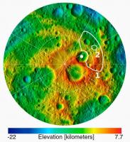
Even the crustal morphology of Ceres will prove to be engimatic.
By the Survey Orbit, Elevation maps were developed and they told a strange story. Ceres has a significant elevation relief of +/-- 7.5 Km around a zero datum. And it seems to be more relief than can be accounted for with a warm-ish icy crust without sagging down or up, back to the datum. But look at the distribution of elevations-- the highland areas are several discrete continents with the abyssal plains in between. Intuitively it would seem that the continental highlands are a low density, thick icy material floating isostatically on the higher density silicates of the upper mantle with the abyssal plains created by relict large impact craters. This is just arm-waving, and we'll learn more from upcoming gravity surveys and determination of the composition of the crust.
By terrestrial analogy, these are granitic crustal blocks bobbing about in basaltic ocean basins.
Illustrations:
A geomorphology map of Ceres showing surface features and continents and abysses:
https://univ.smugmug.com/Dawn-Mission/Ceres/i-74b8Pd9/0/O/PIA19606_fig1--geomorph-v1.jpg
Elevation map, cylindrical projection:
http://photojournal.jpl.nasa.gov/catalog/PIA19606
Elevation map, hemispherical projection:
http://photojournal.jpl.nasa.gov/catalog/PIA19607
Global animation:
http://photojournal.jpl.nasa.gov/catalog/PIA19605
Be thinking about the distribution of surface features on these two crustal provinces.
--Bill
Posted by: Bill Harris Aug 30 2015, 06:02 PM
A montage of SO and HAMO images of "Tall Mountain"
https://univ.smugmug.com/Dawn-Mission/Ceres/i-pDjSWGX/0/O/tall_mtn_montage.png
--Bill
Posted by: Herobrine Aug 31 2015, 04:59 PM
The terrain next to the young crater in today's HAMO release is some of the strangest I've seen on Ceres to date. I don't really know what to make of it.
|
It's times like these that I wish I'd paid more attention to the moons of the gas giants so I might have something to compare it to.
From http://photojournal.jpl.nasa.gov/catalog/PIA19882
Posted by: Habukaz Aug 31 2015, 05:18 PM
The interior of the crater looks rather interesting, too. The bright streaks running down the crater walls, and patches of smooth(er) floor terrain. Guess it's a relatively young crater.
Posted by: ZLD Aug 31 2015, 05:32 PM
Processed enlargement of http://photojournal.jpl.nasa.gov/catalog/PIA19882.
http://i.imgur.com/0HD32Gj.png
(click to enlarge)
Any ideas on the rough patch on the northern side of the crater rim? Strange feature I haven't seen before.
Floor of the crater is really interesting with a sinuous path of something...
On the northern outside of the crater, appears to have been a landslide, while the south side looks like it has slumped some but also looks like it could have been caused by a much less viscous flow into the nearby depression.
Very rough on the western edge as well. This seems pretty consistent with other craters with the white material.
Posted by: Betelgeuze Aug 31 2015, 06:15 PM
Looking at the latest pictures I sometimes wonder if Ceres is just full of sinkholes
Posted by: Bill Harris Aug 31 2015, 06:25 PM
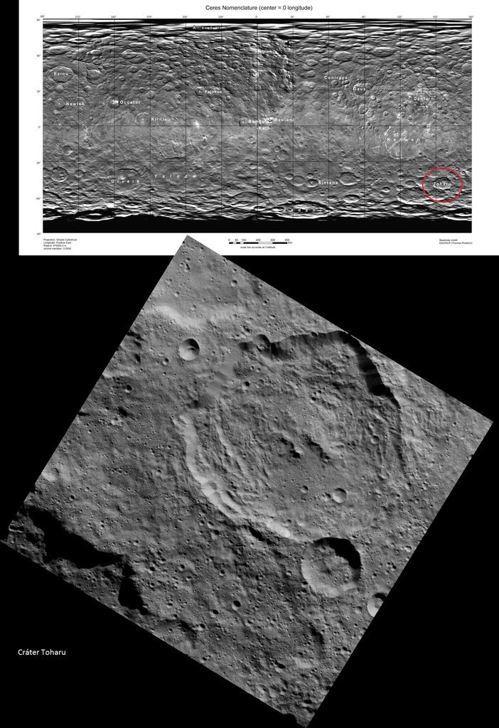
HO-6 is related to Survey Orbit image SO-22 and is located NE of the crater Toharu. It is an unusual Facula because it is located on a Highland area and not on a Lowland plain. This type of bright spot is evidently related to impact ejecta disturbing a zone of light-toned material, whereas the other type of Facula may be related to be an effusive process related to hydrothermal activity.
And looks to be a lot of mass-wasting (slumping) around this crater. And if you look closely there is a lineation (and possibly a line of craters) on the NW rim, cutting through alluvial fans at floor level.
https://univ.smugmug.com/Dawn-Mission/Ceres/i-m2HhrQx/0/L/PIA19882--HO-6--crop1--res3x--enh2-L.png
Just an arm-waving guess, seeing how the puzzle-pieces are fitting together.
I'll also guess that the Haulani crater area will be up within the next couple of orbits.
And this, the Third Day of HAMO...
--Bill
Posted by: Habukaz Aug 31 2015, 07:10 PM
Ah, now it strikes me that this area is very similar in appearance to the http://www.unmannedspaceflight.com/index.php?s=&showtopic=8077&view=findpost&p=225703 of the crater from the previous HAMO image (they are both roughly rectangular).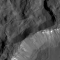
It does indeed look like it could be a landslide of sorts, one that went away from the crater rather than into it. The end result is a locally (relatively) symmetric crater wall, with slopes of similar steepness on both sides of the crater rim.
This topographic feature (note the shadows), partially shown in the previous cropped image, is also very interesting . My eyes want me to believe that there is an overhang in the middle there (the part with a "finger" sticking out), but I don't know if that's even possible to tell from this image.
And, uh, isn't that a plateau on the crater rim? I am starting to like this crater. 
As for the overall appearance of the crater, I am reminded of the way crater ejecta on Mars is interpreted: certain ejecta blankets are thought to be caused by subsurface water. Since Ceres is supposedly full of water, it makes sense to me that impacts here may temporarily liquefy water close to the surface and create a 'mud splash', as is thought to happen on Mars.
Posted by: alan Aug 31 2015, 07:58 PM
It appears that there may be unevenly distributed bright material hidden below a regolith which is being revealed by landslides. The bright spots in the center of some of the craters may be just the most recent places where it has reached the surface.
Posted by: nprev Aug 31 2015, 11:56 PM
Huh. There seem to be a fairly large number of mass-wasting events scattered around, all of which have a relatively fresh appearance. I wonder if Ceres' upper crust is somewhat fragile due to the presence of volatiles and the effects of solar heating; might not take much to trigger an avalanche, might take nothing more than enough solar exposure over time.
Oddly dynamic-looking little world, getting odder with every image. 
Posted by: Gladstoner Sep 1 2015, 01:09 AM
Some observations and thoughts on the recent HAMO release (some points mentioned in posts above):
1. The bits of white stuff in the upper parts of the crater wall are interesting as always. Similar features in craters on Vesta and Phoebe come to mind.
2. There is an almost complete (if not complete) lack of discernable craters of any size within the big fresh crater or its ejecta sheet. This is an indication of a very young crater, very recent mass-wasting events, or both.
3. The ejecta sheet has a degraded look to it. It is as if the material subsided or collapsed in places.
4. There is a straight linear feature (fracture?) running along the base of the wall from 9:30 to 11:30.
5. There appears to be a sinuous 'rille' running the length of the large valley on the north side.
|
Posted by: Bill Harris Sep 1 2015, 02:28 PM
...
Posted by: ZLD Sep 1 2015, 02:40 PM
Care to expand on that Bill? I've looked at the image with the gamma turned up already and didn't see too much to be revealed.
Posted by: MarsInMyLifetime Sep 1 2015, 02:53 PM
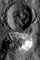
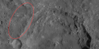
I agree that this crater is clearly a relatively fresh impact crater, but I suspect it is too small to have been a cause for any fractures or visible changes to the surface other than the obvious ejecta and some later slumping indicated by the detritus in the basin. The crater south of Tall Mountain seems quite a bit different to me in that it has no obvious ejecta and the basin floor looks suspiciously like the plains surface surrounding it. I'm strongly reminded of the sinkholes here in the Texas limestone country where the surface texture pretty much collapses intact into failed caverns, and naturally with no upheaval/ejecta material around them. So that's in the back of my mind as I compare the two craters (and ponder what subsurface activity may also account for the formation of Tall Mountain beside it--I am now under the impression that all the large craters around Tall Mountain may in fact be linked by subsurface activity).
Posted by: ZLD Sep 1 2015, 04:08 PM
Processed enlargement of http://photojournal.jpl.nasa.gov/catalog/PIA19883.
http://i.imgur.com/0rUAYaY.png
(click to enlarge)
Can't say with any certainty but the feature at the top left in the image has a very large shadow for its apparent size and may be a slight overhang.
Posted by: pac56 Sep 1 2015, 09:00 PM
1. The bits of white stuff in the upper parts of the crater wall are interesting as always. Similar features in craters on Vesta and Phoebe come to mind.
2. There is an almost complete (if not complete) lack of discernable craters of any size within the big fresh crater or its ejecta sheet. This is an indication of a very young crater, very recent mass-wasting events, or both.
3. The ejecta sheet has a degraded look to it. It is as if the material subsided or collapsed in places.
4. There is a straight linear feature (fracture?) running along the base of the wall from 9:30 to 11:30.
5. There appears to be a sinuous 'rille' running the length of the large valley on the north side.
|
|
The feature at 9 o'clock (number 3) reminds me of "half Tall Mountain". Tall Mountain is also very close to the rim of a crater. Could it be that the impacts lifted part of the surface à la pingo? Maybe the angle of impact makes a difference?
Posted by: Bill Harris Sep 1 2015, 10:26 PM
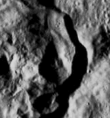
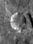
HAMO-7 is an example of crater internal slumpage:
http://photojournal.jpl.nasa.gov/catalog/PIA19883
The large crater is Toharu
--Bill
Posted by: Landru79 Sep 2 2015, 12:01 AM
Can't say with any certainty but the feature at the top left in the image has a very large shadow for its apparent size and may be a slight overhang.
I think the crater in the center of HAMO 7 is Toharu and the shadow on its left another big one

http://foro.sondasespaciales.com/index.php?topic=9441.msg130295#new
Posted by: ZLD Sep 2 2015, 04:36 PM
Processed enlargement of http://photojournal.jpl.nasa.gov/catalog/PIA19884.
http://i.imgur.com/dtAsPhG.png
Seems the compression is much higher on this image than the past several HAMO TIFFs. Not sure why.
Not many new revealing items in this release. One feature of note is the bright spot, previously visible as just a white blob in SO10, SO19, SO40, SO42, is indeed a crater, very similar in appearance to Haulani and other craters with the white material, just on a much smaller scale. Also, another crater to the north that is caving inward.
Posted by: hendric Sep 2 2015, 06:14 PM
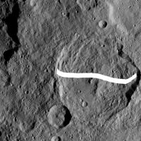
Please, tell me I am going crazy, there is no way Toharu is really a wide-area of sinking ground... But...The amount of correspondence is just downright creepy...
|
Posted by: ngunn Sep 2 2015, 07:10 PM
One feature of note is the bright spot, previously visible as just a white blob in SO10, SO19, SO40, SO42, is indeed a crater
Well I'd say that feature is very interesting indeed. At last we see clearly the crater within one of these small white spots. Not only that, but where there would normally be a pitch black shadow inside it we see details backlit by light from the sunlit part of the interior.
Posted by: ZLD Sep 2 2015, 08:12 PM
Took me a bit to understand why you painted a white line on the image Hendric then I realized finally that you cut and moved a section of the crater floor. This seems to lend some evidence to sinkholes being on Ceres. Based on other (suspected) impact craters with a lot of slumping, it could also be the result of an impact meeting a certain energy threshold that causes the surface to destabilize. Maybe the soil is made up of solidified mud with locked up water crystals that, when heated from a large enough impact, get released and sublimate away, leaving the soil very brittle and likely to collapse. Could also be driven by an annual cycle.
I know it isn't planned but I hope that when the mission is done and Dawn is left in it's final orbit, that they can drum up some support for a Cerian Summer mission. Would definitely bring some insite into how an ice body behaves at the frost line.
Posted by: charborob Sep 3 2015, 12:18 PM
If anybody has some free time, here's a suggestion for a project: trace the outlines of the published HAMO images on a map of Ceres.
Posted by: Bill Harris Sep 3 2015, 01:20 PM
Is there any reason you cannot do it? You've got many anagrams and panoramic mosaics on the forum.
Posted by: ZLD Sep 3 2015, 02:07 PM
Its funny you mention that charborob. Already had started this yesterday.
http://i.imgur.com/EyPXEFB.png
(click to enlarge)
HAMO 4 doesn't fit super well since it is so far north, so I've just noted it slightly to the southwest of its location. I'll get it fit eventually but my map skills are lacking. HAMO 8 hasn't yet been traced but I noted the location on there.
Posted by: charborob Sep 3 2015, 02:42 PM
Thanks, ZLD. That's exactly what I was thinking about. I could have done it myself, but I don't have any time to spend on this project. Maybe you could post your updated map once in a while.
Posted by: ZLD Sep 3 2015, 02:46 PM
I plan to update it with each HAMO release so I'll just include it with those.
Posted by: Habukaz Sep 3 2015, 04:34 PM
Interesting fissures in http://photojournal.jpl.nasa.gov/catalog/PIA19885. I had some trouble locating the crater, but it lies south-west of Occator and is visible e.g. in http://photojournal.jpl.nasa.gov/catalog/PIA19579 (there is a characteristic pawprint to its north-west that makes it easier to recognise).
An interesting question is where its bright stuff comes from - is there a fresh crater just outside the frame?
Posted by: ZLD Sep 3 2015, 05:10 PM
Processed enlargement of http://photojournal.jpl.nasa.gov/catalog/PIA19885.
http://i.imgur.com/su8jv9G.png
(click to enlarge)
I also had a lot of trouble finding this crater. I tried your suggested location Habakuz and it looks similar in SO11 but on the map, it doesn't seem to line up at all. Maybe I'm missing something.
Edit: It was the same area you mentioned in SO11, Habakuz. A slightly better lit capture is in http://photojournal.jpl.nasa.gov/catalog/PIA19624, at the very right edge near the top. On the map, the area is somewhat blurry so it was difficult to tell what was going on.
http://i.imgur.com/2UguGQG.png
(click to enlarge)
Survey orbit locations are simple approximations.
Posted by: charborob Sep 3 2015, 05:16 PM
Interesting slump or flow around the 4 o'clock position on the inside crater rim.
Posted by: ZLD Sep 3 2015, 06:00 PM
Also looks like the start of a massive slump here.
|
Posted by: Habukaz Sep 3 2015, 06:23 PM
That looks like it, yes. No obvious sign of any bright, smaller impact crater nearby from that angle, either; which is interesting (or have we already seen something similar elsewhere in the solar system?).
Posted by: Bill Harris Sep 3 2015, 06:46 PM
Thanks-- that spotting the HAMO images on the cylindrical map is a major (but burdensome) intitial task in plotting their footprint on the SO-imagery.
--Bill
Posted by: HSchirmer Sep 4 2015, 01:38 AM
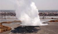
Perhaps this is similar to the https://en.wikipedia.org/wiki/Sidoarjo_mud_flow
Theories are that it was triggered when drilling breached the surface clay,
which let out mud and gas beneath.
http://www.berkeley.edu/news/media/releases/2008/06/09_lusi.shtml
Interesting thing, the area may be sinking into a sort of caldera.
Tons of pictues
http://www.crisp.nus.edu.sg/coverages/mudflow/
|
Posted by: ZLD Sep 4 2015, 04:32 PM
Processed enlargement of http://photojournal.jpl.nasa.gov/catalog/PIA19886.
http://i.imgur.com/TQvwi3u.png
(click to enlarge)
Doesn't seem to be much new to note here. Several very fresh looking craters scattered in this area.
Imaging map with HAMO 10 near the Toharu crater once again.
http://i.imgur.com/2rMZEB6.png
(click to enlarge)
Looking at the typical progression of images, there should be a good nadir position for capturing Occator for the next orbit but who knows if they'll release it or not.
Posted by: Daniele_bianchino_Italy Sep 4 2015, 08:26 PM
In september 2013 a new island formed by a 7.7 pakistan earthquake; The island is a mud volcano that had been caused by an emission of methane gas on the seabed.it resemble a big mount over Ceres: 
Posted by: Bill Harris Sep 4 2015, 09:59 PM
HAMO image HO-10 is noteworthy because it straddles two major Cerean terrains.
https://univ.smugmug.com/Dawn-Mission/Ceres/i-pgQrHFs/0/L/HO-7_HO-10--pano--enh2--orient-L.png
--Bill
Posted by: RotoSequence Sep 5 2015, 03:09 AM
Hmm. Good catch! The same mud volcano, from above:

Posted by: Habukaz Sep 6 2015, 05:24 PM
Theories are that it was triggered when drilling breached the surface clay,
which let out mud and gas beneath.
http://www.berkeley.edu/news/media/releases/2008/06/09_lusi.shtml
Interesting thing, the area may be sinking into a sort of caldera.
Tons of pictues
http://www.crisp.nus.edu.sg/coverages/mudflow/
Primarily thinking about the bright stuff scattered around the crater - not quite sure how this would relate to it. We have seen plenty of bright impact crater elsewhere in the solar system, but I don't recall seeing older craters with specks of bright stuff around them (but I guess it could simply be the last remnants of a more massive cover of bright stuff that the crater once was surrounded by).
Posted by: Bill Harris Sep 7 2015, 08:17 AM
New images to Ceres Gallery, including a study of a crater-facula in HAMO-8, stereo imagery in SO-24,-25, and episodic emplacement of fluidized flows in HO-4.
https://univ.smugmug.com/Dawn-Mission/Ceres
What a quirky little world.
--Bill
I am a traditionalist-- I like to do image montages ("stitching") and stereo pairs manually. But yesterday I finally broke down and got a copy of Stereo Photo Maker (freeware and a dang good program-- support your local developer!!) and last night I redid the two SO-24,-25 stereo pairs noted above. Enjoy.
--b
Posted by: ZLD Sep 8 2015, 05:07 PM
Processed enlargement of http://photojournal.jpl.nasa.gov/catalog/PIA19887.
http://i.imgur.com/XO8uxra.png
(click to enlarge)
Imaging location map.
http://i.imgur.com/HTE7lpg.png
(click to enlarge)
It took me a while to realize that HAMO 11 was located right in the middle of SO4. Smacked my forehead on that one. No further updates on SO locations with this one.
Posted by: Steve5304 Sep 8 2015, 07:51 PM
images of spot 5 are being held from the public because of a peer review pending paper. Im told that the new pictures are wonderful and reveal alot the spots appear to be resembling a lake bed and some sort of dusting material all over the place in and out. The material is still not known..tho its openly being speculated its some sort of new element. something we dont know about yet. It may be many more weeks before occator images are released.
Posted by: stevesliva Sep 8 2015, 08:36 PM
unobtanium or ice-9, definitely.
Posted by: Steve5304 Sep 8 2015, 08:40 PM
heh..maybe its elerium
whatever it is supposedly lt doesnt subliminate and yet is above the crater. but its not ice and not salt :shrug:
who knowsyet. the embargo on the images by nature mag it sucks
Posted by: Habukaz Sep 8 2015, 09:19 PM
After some searching, I was able to find an interview with Christopher Russell on a dubious website (though the interview itself seems fine enough) saying pretty much the same thing (about an embargo):
[...]
the trouble with getting involved with these journals, the paper's been sent out for review, but it isn't accepted, so we're in this Never Never Land of not knowing [the embargo date]. But the new pictures are lovely.
(https://www.earthfiles.com/news.php?ID=2349&category=Science)
I have seen nothing about this in other channels, though.
Posted by: ngunn Sep 8 2015, 09:44 PM
I'm expecting to se a clutser of impact craters somewhat modified by subsequent sublimation (including hazes).
Posted by: fredk Sep 8 2015, 09:49 PM
That sounds like a pretty extreme conclusion from very limited data.
Btw, Russell is quoted in that interview as saying "And this white stuff might have an albedo of 50 percent." I think that's the first mention I've heard of an albedo value.
Posted by: Habukaz Sep 8 2015, 10:05 PM
If this embargo is really happening, can we even be sure that we'll see the HAMO images of Occator before the LAMO images of it?
Posted by: ZLD Sep 8 2015, 10:10 PM
Thanks for that link Habakuz. That interview had several interesting points.
Posted by: Phylan Sep 9 2015, 12:55 AM
Somebody linked me to that on Twitter, and the interview (and the explanation) seem perfectly plausible, but it seriously bugs me that the only source for it is a website that, well, looks like that, and whose content is 80% UFO nuttery.
Posted by: Bill Harris Sep 9 2015, 12:56 AM
I could care less. It's their science and their papers-- after all, their career track is governed by the "publish or perish" rules. If they feel it necessary to embargo THE photo of the year til the paper gets out and oo'ed & ah'ed, that's fine. In the Big Picture, it'll just be another pretty picture. In the meantime there are a multitude of puzzle pieces coming out with each HAMO image. Nothing spectacular, but individual puzzle pieces generally aren't-- it's the sum that is important.
Anyways, with the Occator Spots, I think they are hydrothermal features-- various salts entrained in the escaping vapors and left behind as the gases expand and dissipate. The big surprise may be which salts in what gases.
--Bill
YAY TEAM-- we got HAMOs of the Occator Faculae. And first thing in the AM. Good show.
-b
Posted by: Phylan Sep 9 2015, 01:20 AM
Speak of the devil:
https://twitter.com/NASA_Dawn/status/641420466029113344
Posted by: tanjent Sep 9 2015, 02:15 AM
Regardless of the website source, the interview seems better than "perfectly plausible" in my estimation.
The questions were tough and well-informed, and the answers were candid and not at all evasive.
Ms. Howe gives a pretty good model of how to interview a researcher about delicate or breaking news, but of course it is not a substitute for the pictures themselves. I hope we will see them pretty soon.
Posted by: Steve5304 Sep 9 2015, 02:16 AM
im glad it was just a rumor. seemed to have a hint of credibilitg.
nice to get a name drop
Posted by: ZLD Sep 9 2015, 03:03 AM
So was this an actual misstep in communication among the team or is the interview bunk? It's a fairly well written work of fiction if that is the case. Strange slip-up otherwise if it is true...
Posted by: Phylan Sep 9 2015, 04:12 AM
If I'm understanding their twitter correctly, there was a paper submitted and embargo was a possibility but they've determined it doesn't extend to the pictures. Which probably means the interview was real.
Posted by: elakdawalla Sep 9 2015, 04:43 AM
In my view there's a lot of excessive caution with regards to Nature and Science embargo policies, but on the other hand I can't blame scientists for being skittish. I've often observed that the best way to be certain about exactly what the embargo policy means is for a scientist to make a public statement that an embargo prohibits them from sharing information -- then Nature or Science "clarifies" the policy and says it's okay to share
Posted by: ZLD Sep 9 2015, 01:41 PM
Photojournal was uploading pictures of Occator when suddenly, right after I had opened the nadir view, it disappeared...Just want to confirm with everyone that it would be ok to repost it here. It looks very intriguing indeed.
Apparently it's still there, the thumbnails is just incorrect. http://photojournal.jpl.nasa.gov/catalog/PIA19889
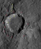
Posted by: Phil Stooke Sep 9 2015, 01:41 PM
Occator enlarged.
Phil

|
Posted by: marsbug Sep 9 2015, 02:10 PM
The brighter areas do look to be associated with the fault-like features to me. Also (only to my very ameatur eyes) I see nothing that looks like a conventional crater-and-ray. The central peak looks like it's, well, snow capped (salt capped possibly?).
Posted by: Habukaz Sep 9 2015, 02:23 PM
Still looking weird as heck. Lots of fissures in Occator, too.
The fact that it is a composite image of different exposure times make it somewhat harder to interpret.
What's this; topography or dark material?
And these dark patterns on the rim? Processing artefacts or real?

Posted by: dvandorn Sep 9 2015, 02:34 PM
I'm not thinking that the central feature is primarily a raised feature. Be it an impact crater or a caldera, the main bright area is nicely tucked into a circular feature, isn't it? But the very straight cracks, especially the one going straight up in your detail, Phil, are not very deformed by the circular feature. So, the cracks seem to have formed after the circular feature. And while the lighting doesn't give a lot of clues, I get the impression of there being a building central mound within the larger crater- or caldera-like depression.
I also think I may see what Russell, et al, have been discussing -- if you look at the very end of the crack that, again in this detail, runs straight up from the main bright area, there are a couple of very subtle dark streaks in the little bit of brightening around that end of the crack. While I can't, obviously, say this is happening for certain, these streaks resemble shadows cast on the surface from the densest portion of a fountain of material coming out of the top end of that crack. Recall that Enceladus is pumping out a lot of material along its tiger stripe cracks, and yet the only real visible clue it's happening when looking straight down into the cracks from Cassini has been such subtle shadowing.
The area of the secondary bright area, at the 2:00 position from the main bright area in the detail above, is sitting within an irregular boundary of a low, continuous scarp that makes something of a sausage- or cigar-shaped enclosure. Could represent cooling of a once-liquid body, akin to a lava lake, or could even represent a small, irregular caldera-like formation grown from escaping material from a crack that may have once run underneath it. If so, that crack appears to have been completely buried by now.
Finally, look for obvious impact craters. In the entire detail image, I see two very small ones. Even if this is a fairly new crater (and I dispute that, based on the amount of mass wasting I see in the walls), I would expect to see more small craters on its floor. The conclusion is that the floor, in the general vicinity of the bright areas, has been resurfaced by processes far more recent that the creation of Occator.
Now, let's get some LAMO images... 
-the other Doug
Posted by: Habukaz Sep 9 2015, 02:42 PM
The lack of impact craters inside Occator is a fair point; but there are not many impact craters outside it, either (i.e. where the ejecta blanket should be), which is consistent with Occator being a relatively young impact crater.
Posted by: climber Sep 9 2015, 02:52 PM
Side view from next orbits will help assessing the relief before LAMO.
Do I see a trianguler "hole" at 9 O'clock?
Posted by: ZLD Sep 9 2015, 03:03 PM
Processed enlargement of the http://photojournal.jpl.nasa.gov/catalog/PIA19889.
http://i.imgur.com/X8xUlks.png
(click to enlarge)
I would really like to see this composite separated. It played havoc with the overall quality. I'm not positive but I think the south edge of the central spot is even showing a misalignment, possibly due to a change in orientation of the spacecraft.

|
At the south of the crater is some interesting fracturing that seems to spread from a common point. Contrasting with the slumps on the edges of this and other craters, it appears that at the north, there is a slump or flow outward toward the crater wall as if something had flowed from the center out. This could be a lighting illusion though.
A while back I also made a blinking GIF comparing an unprocessed crop from SO16 with a processed enlargement which still seems to have relevant features.

|

|
----------
Edit
----------
I did a comparison between the SO 16 processed image and the current HAMO view and if it is not simply artifacts, there's a (limited) possibility that we could see some active movement in this area. Probably just artifacts though. I'm going to hope it isn't though.

|
Most notably, the dark patch that seems to disappear from the brightest area.
Posted by: Steve5304 Sep 9 2015, 03:45 PM
think we can rule.out abandoned mining colony. tho it made for some great reading.
i think the triangle at 9 oclock is an artifact same tging you see at 12 and on crater walls. what im seeing is totally bizzare..why cant it be ice? it looks like ice. it also looks like venting at 2 oclockor paradoliea
Posted by: centsworth_II Sep 9 2015, 03:58 PM
"I have heard no report back from the team on any signature of ice from the VIR spectrometer, so I'm going to say it must be some sort of salt."
Posted by: machi Sep 9 2015, 05:59 PM
It looks similarly to some Mercury's craters.

|
Posted by: Bill Harris Sep 9 2015, 05:59 PM
Initially, a comparison between an early Survey Orbit image of the "Occator Spot" and this first public HAMO image of this feature.
https://univ.smugmug.com/Dawn-Mission/Ceres/i-QRWNnMp/0/O/PIA19579--Spot5--PIA889_HAMO.png
Otherwise, I am somewhat giddy from what I'm seeing here.
--Bill
Posted by: hendric Sep 9 2015, 06:10 PM
Looks like at the 9 o'clock position that the flow from the central white spot, hit a rise and was diverted north.
But overall, to me Occator is starting to look less like an impact crater and more like a series of collapsed calderas, with the white spots the latest stage of rebuilding.
North of the central white spot, there is what looks like a lava flow front, with bands following the edge of the front.
There's a clear halo to the north of the CWS, ending a little north of the straight crack, but also extending to the right, up to where the small mound is located on the surface. The edge there could be the end of a lava flow, since it looks higher than the area further east. On the western side, it's hard to tell from the JPG but it looks like the flows have bypassed back and forth past some higher ridges, with some curves just the left of the bad spot on the imager (or those could be ringing from excessive edge enhancement, it's difficult to tell here). NW at 11 o'clock is what looks like an old flow, slightly lighter than the surroundings, extending past the halfway point to the rim.
Many of the smaller white spots away from the CWS and the NE quadrant appear on the side of a crack - maybe the cracks were tilted, with fountains aiming mostly down hill.
My bet is on the white material being salty slag left over after the cryovolcanic ice has sublimated away. As the activity on Ceres ramped down, this happened to be the last gasps, with Occator being a volcano that once it collapsed, continued to have some activity, but never enough to get past its outer collapsed caldera. Each active cycle laid down a little less new salt, with the older salts darkening over time.
Posted by: Gladstoner Sep 9 2015, 07:50 PM
I wonder if the other craters with central pits once had Occator-like events/processes but have since faded.
|

|

|
Posted by: Bill Harris Sep 9 2015, 08:31 PM
And how does the visually bright Facular material change with time if not renewed? Could it darken and fade to match the tone of the surface, or even darken and diffuse to look like a Macula? I have a feeling (hope?) that it will have a distinctive spectral signature and stand out in VIR imagery
--Bill
Posted by: MarsInMyLifetime Sep 9 2015, 08:37 PM
Just my own high level conjectures at this point: while the light material is clearly draping, we can classify draping as either new/durable or older/decayed. The draping features on several of Jupiter's moons represent new/durable and possibly ongoing accumulation. Here, if the draping is new, we'd have to explain its absence from many areas within the draped region. I'd expect salts, regardless of their type, to be a durable material whose draping would persist and perhaps discolor evenly, but not dissipate. So far, this is looking like an older event comprised of a material that has had time to either dissipate, become preferentially altered, or be partially covered by very localized dark draping events (that is, the dark circles may not be pits but spots). A final possibility is that the buildup is preferential, not sticking to some surfaces. The terrace-like nature of the big spot may be such a build-up. I don't see any mechanisms for particulate fallout to deposit preferentially. So I'm going with an older, volatile, decayed surface not involving salts, with a backup option of a newer surface (ice or salt) altered by "smokers" or sublimation. What else could explain the apparently differentiated draping?
Edit: I think Bill and I were experiencing similar thoughts about appearances while writing our posts!
Posted by: eliBonora Sep 9 2015, 08:41 PM
Hi all,
an anaglyph obtained with the last image and the latest from survey and a detail of the last photo.
https://flic.kr/p/y8ApXm
https://flic.kr/p/y8ArQS
It seems that a part of the main "Bright Spot" has slipped to the dirty-white area, upper right of the image, leaving two tracks.
Posted by: ZLD Sep 9 2015, 08:52 PM
It would seem reasonable to me that it has happened in at least one other location on Ceres, even if time has since made it difficult to observe. I still think Ceres has been a very cryovolcanically active body in the past and very possibly still now. The closer we get to the central area in Occator, the more similarities I see with other larger craters with the exposed white material, namely Haulani. I think Haulani represents a much older and possibly larger version of the events that are just beginning at Occator.
Updated imaging map:
http://i.imgur.com/Ww6BdNF.png
(click to enlarge)
----------
Edit
----------
Also, here is an attempt to pull out everything possible from the central and brightest blob.

|
Looks like there could be a fissure running through the center. Overall, looks like a mini version of the larger pit surrounding it.
Posted by: Charles Sep 9 2015, 09:24 PM
It also looks somewhat similar to an aerial view of Old Faithful (minus the public reception area).

|
Posted by: Gladstoner Sep 9 2015, 10:47 PM
If any fluids in the interior are able to collect in pockets (in the manner of petroleum and natural gas reservoirs on Earth), and not dissipate or freeze out, they could eventually make it to the surface as an eruption. It doesn't matter how long the planetary body has been otherwise 'geologically inactive'. This could be the case with gases in the Moon and Mercury as well as liquids and/or gases in Ceres. In any case, though, a conduit to the surface needs to be opened by some direct or indirect process(es) for an eruption to occur. The faults and fractures associated with an impact rebound could serve such a purpose.
Posted by: Steve5304 Sep 10 2015, 05:40 AM
played around with photoshop..bring out more details. zoomed in and im not sure if it is an actual feature or not. Some sort of dome appears be rising out of the center of the bright spots. have a look
http://m.imgur.com/sQP6wcA
it could also be an illusion..considering this is actually two pictures overlayed from nasa. guess we will have to wait till LAMO.
Posted by: dvandorn Sep 10 2015, 10:59 AM
A central, eruptive mound is how the main bright spot appears to me, as well. And while there are a number of bright spots around Ceres, this is the only feature that has the appearance of being eruptive.
-the other Doug
Posted by: Nafnlaus Sep 10 2015, 11:11 AM
Maybe I missed it, but are there any theories as to why grabens seem to be so common in these craters, and with directions that seem to lack any apparent regard to their location in the crater? I noticed that they seem in some cases to run straight across white spots, indicating that they're younger than the white spots (including if, as hendric suggests, that they're salt deposits left behind from sublimated saltwater ice - then time for all of the volatiles to sublime). This would seem to indicate that they're not all formed at the same time as whatever causes the saltwater to surface (if that is indeed what's actually happening here). The tectonic activity is proportionally young.
As for saltwater oceans, frozen or not... Enceladus seems to be producing an ultrabasic soda ocean with relatively little heat input via serpentinization of rocks with its core. If the spectra come back with significant Na2CO3 then we may be looking at something like that here. Which would be really interesting, as serpentinization also gives off H2.
Posted by: OrbitrapInSpace Sep 10 2015, 11:13 AM
I am surprised that in the interview with Christopher Russel, Russel seems to link Haze with an atmosphere -necessary - to levitate or maintain some material aloft. The LDEX instrument on LADEE was designed and operated around the moon in 2014 to "gauge the relative contributions of the two competing dust sources: (1) ejecta production due to the continual bombardment of the Moon by interplanetary micrometeoroids, and (2) lofting of small grains from the lunar surface due to plasma-induced near-surface electric fields"
paper http://link.springer.com/article/10.1007%2Fs11214-014-0118-7
description http://www.space.com/18538-moon-dust-ladee-lunar-mission.html
If the white material that deposited in occator is very fine (0.1 micron for the moon), the same process could take place and show variability along cerean day and eventually lead to time dependent haze...
Posted by: ngunn Sep 10 2015, 11:26 AM
I've just been looking at Emily's anaglyphs and thought I could see a hint of a central protuberance in Haulani crater. It will be interesting to compare it with the Occator feature when a similar anaglyph of central Occator becomes possible. http://www.planetary.org/blogs/emily-lakdawalla/2015/09091743-dawn-ceres-image-bonanza.html
Posted by: ZLD Sep 10 2015, 01:53 PM
Haha, hadn't seen that on her blog yet. Emily, that map took multiple aggravating hours I'm sure! Great to stereo images as well.
Posted by: JRehling Sep 10 2015, 02:10 PM
I did a Google Maps grab of the Old Faithful area in Yellowstone before seeing that Charles had posted a more close-up view of the same area. I'll try to provide a side-by-side comparison.
Ceres has 3% of Earth's surface gravity, so a projectile would travel 1/sqrt(3%) = 6 times farther across the surface.
So, here are the Occator bright spots next to geyser deposits at Yellowstone on Earth, with the Earth imagery magnified six times to illustrate how they might project under Ceres gravity. This, however, also scales up the distance between vents, which has no bearing on anything.
Occator ~ Yellowstone on Ceres?

|
Posted by: Nafnlaus Sep 10 2015, 02:51 PM
Why sqrt?
Posted by: elakdawalla Sep 10 2015, 03:01 PM
And thanks to you for your maps, you saved me many aggravating hours staring at craters to try to match them with the base map.
Posted by: ZLD Sep 10 2015, 04:44 PM
Processed enlargement of http://photojournal.jpl.nasa.gov/catalog/PIA19888.
http://i.imgur.com/PTw4hsn.png
(click to enlarge)
Seems consistent to past images we've seen of this area.
Imaging location map:
http://i.imgur.com/TwvW61f.png
(click to enlarge)
HAMO12 is located to the southwest of Toharu in the southeastern region. I will probably adopt a lot of the conventions in your map Emily and further refine positions over time.
Posted by: TheAnt Sep 10 2015, 05:11 PM
A bit early for theories, but we sure got plenty of ideas!
Some time back I made a post where I speculated it would turn out to be be salts in most of the bright areas. But the kept the door open for Occator, thinking it might perhaps be one exception.
Now since we see the graben run trough some parts of the white area, (thanks to eliBonora for those processed images) I'd say this rather strengthen the case for salts.
Ice would have to be relatively new, more recently exposed - geologically speaking, exposed ice will sublimate since it is exposed to near vacuum.
Now with those graben the date is pushed far back for the formation of Occator, and since I don't have any professional reputation to taint, - I now feel quite biased to think the bright Occator is made of salts after all.
This does not exclude the idea that the bright features once were formed by some eruption or geyser-like event - but it seem to have happened further back in time.
Posted by: JRehling Sep 10 2015, 06:37 PM
The distance a projectile will travel horizontally is proportional to the square root of the acceleration due to gravity. I'll leave the equations out of my answer and you can trust me or work it out for the fun of it.
ERRATUM: The distance a projectile will travel horizontally is inversely proportional to the acceleration due to gravity. The distance a ballistic projectile will travel on Ceres is about 35 times that of a similar projectile on Earth.
Posted by: Nafnlaus Sep 10 2015, 07:56 PM
If an horizontally-moving object needs to fall 1 meter to hit the ground and is in a 1 m/s^2 gravity well, it hits the ground 1 second later.
If the same object needs to fall 1 meter and it's in a 4 m/s^2 gravity well, it hits the ground 0.5 seconds later (4m/s^2 * (0.5s)^2 = 1m)
Quadruple the gravity, halve the fall time and thus the travel distance. Cut gravity in a quarter, double the fall time and travel distance.
Gravity squared is proportional to travel distance. Travel distance is proportional to gravity squared.
Ceres gravity is 3% that of Earth's. Travel distance on Ceres is proportional to 1/(3% earth gravity)^2, or about 1100 times as far.
Right?
Posted by: Mongo Sep 10 2015, 08:15 PM
t = sqrt(2d/a) = sqrt(2) = 1.4142... seconds
t = sqrt(2d/a) = sqrt(2/4) = 0.7071... seconds
Gravity squared is proportional to travel distance. Travel distance is proportional to gravity squared.
Ceres gravity is 3% that of Earth's. Travel distance on Ceres is proportional to 1/(3% earth gravity)^2, or about 1100 times as far.
Right?
The rest of the argument is correct.
Posted by: HSchirmer Sep 10 2015, 10:59 PM
Could be like the pits on mercury. Mass wasting of volatile material.
Big question is, what counts as "volatile" gone in a day, a year, a century, an eon?
Second question, is that wasting triggered by the heat of the impact,
by removal of an insulating dust layer, or both?
I'm thinking of recent Brown U. research that some weird lunar patters "swirls"
result from a transient atmosphere as a result of a comet and it's coma hitting the moon.
Not sure why, but I don't think just saltwater is likely, perhaps something more hygroscopic, some sort of silicate mud? \
That could create some neat formations, a mix of mid ocean ridge "black smokers", mono lake "tufa towers" or frozen geysers.

|
Posted by: JohnVV Sep 11 2015, 02:27 AM
i few different views of
http://www.jpl.nasa.gov/spaceimages/details.php?id=PIA19889
http://imgbox.com/yhbMAwww http://imgbox.com/Xioiblx9 http://imgbox.com/ITbw6634 http://imgbox.com/cH1tGqzs
the height is exaggerated
Posted by: ZLD Sep 11 2015, 05:43 PM
Processed enlargement of http://photojournal.jpl.nasa.gov/catalog/PIA19892.
http://i.imgur.com/IhOhGPG.png
Not sure why they have skipped HAMO 13.
More white material in this image. This is also from an area with a high number of linear streaks. One in particular appears rather dark in comparison to the others, noted in the image below.

|
This could just be an effect from lighting but I haven't seen anything similar to it elsewhere on Ceres yet. It also seems to be visible in SO37 (PIA19610).
Imaging location map
--------------------------------------------------
http://i.imgur.com/dtwpyQL.png
This one took a while to find. It was an area only imaged twice and once was near the edge in a limb view.
Posted by: JRehling Sep 11 2015, 07:06 PM
The dark "streak" looks to me like a shadow following a ridge, and there are indications of other, fainter ones parallel to the most obvious one.
Posted by: Bill Harris Sep 11 2015, 11:48 PM
Look closely and that dark streak in the Western corner (lower left) is real, and associated with another important (but very subtle) terrain type-- muted terrain. This is a draping and softening unit also associated with crater chains and lineations.
--Bill
Posted by: dvandorn Sep 12 2015, 01:55 AM
Thank you, Bill. I've been seeing this for quite some time. I've been calling these draping units "splash-emplaced terrain," and words to that effect, since some of the most obvious examples lie around the larger basins. But there seem to be many overlapping draping units of many ages. It's going to be tough to sort them all out.
-the other Doug
Posted by: Bill Harris Sep 12 2015, 02:33 AM
Yep, it's a big Rolling Conundrum. I have two similar units cataloged from the Survey Orbit imagery: Internal slumpage or flowage features, on the inside of craters and External flowage or slumpage features, occurring on the outside of craters. These two landforms are somewhat similar, but the better-resolution mapping imagery is showing more differences, and I'm starting to think of the "muted terrain" as different than some of the "external flowage terrain" and needing to go back and change the earlier SO-image annotation overlays.
One big headache is trying to figure out what to call these new landforms and find myself referring back to a lot of the USGS planetary reference material. I'll be glad once papers start getting cranked out on these "dwarves" and we start getting community-wide nomenclature standards established.
--Bill
Posted by: Bill Harris Sep 13 2015, 12:53 AM
New comparison between the June 2015 SO-11 image and the August 2015 HAMO image of the "Occator Faculae".
https://univ.smugmug.com/Dawn-Mission/Ceres/i-LTCgGvr/0/O/PIA19889--HAMO--res2x-%2B-PIA19579--SO-11--compar.png
--Bill
Posted by: MarsInMyLifetime Sep 13 2015, 02:16 AM
I had mentioned earlier that a static draping mechanism didn't seem right because the dark areas needed to be explained. Thanks to the scale of Bill's upper image, the dark areas appear to be not a dark draping, but pits that evidence removal of the ground from beneath the draping material, leaving deep voids like holes in Swiss cheese. I can't profess to understand what gas might be escaping from there, but it looks like a phased event: first the deposition of salts, perhaps with some ejection of globs of that material around the area, followed by a less dusty outgassing event that has etched out some of the cracks and dust between blocks under the desposits. Water vapor is not out of the question, but other gases released from under pressure also seem likely. For today, at least, this scenario lingers as I look at that image.
Posted by: JohnVV Sep 13 2015, 02:53 AM
those might be pits ?
there is a dark black line next to the light area

|
see the arrows
Posted by: MarsInMyLifetime Sep 13 2015, 03:13 AM
there is a dark black line next to the light area
|
|
see the arrows
Bill's upper image here https://univ.smugmug.com/Dawn-Mission/Ceres/i-LTCgGvr/0/O/PIA19889--HAMO--res2x-%2B-PIA19579--SO-11--compar.png shows that edge to be more of what I would call a curve fringed by a shadow falling on slightly less dark terrain below the edge. By my eyes, a pit. The more I stare at it, the more riddled the whole mound looks.
Posted by: fredk Sep 13 2015, 04:30 AM
Remember that two different exposures were merged for this image. The boundary you've marked is likely between the two images, so you can't trust any details you see there. We have to wait till we have access to the two original frames.
Posted by: Bill Harris Sep 13 2015, 08:03 AM
Exactly. They may be pits, but they may likely be not. If you enlarge and tweak that same spot from my comparison image this is a darker area of the floor with maybe a ledge and shadow next to it. And that gray triangular area to the left/upper-left of the Spot is the central peak of Occator crater. Remember, this is a difficult area to image-- the floor is a very dark gray and the spot is a very light white, almost like snow on a coalpile, and two different exposures were needed to photograph it.
In the Caption of that image I noted that an apparent significant change in the group of spots as insignificant:
==
Although the earlier SO image is less clear, similar features can be spotted on both images and over the time span it appears that no significant changes have taken place. Note that the pair of spots on the Eastern side are less prominent in the HAMO image than in the SO image. It may well be that this pair of spots shows decreased activity in the later image, but it might be that this is simply an artifact of NASA compositing the image.
==
Since this image was composited by NASA I'm being careful on making pronouncements. However, I do think I can see a system of radial fractures around the large Spot, which may be a clue to it's origin.
--Bill

|
Posted by: ZLD Sep 14 2015, 06:13 PM
Processed enlargement of http://photojournal.jpl.nasa.gov/catalog/PIA19893.
http://i.imgur.com/wM4o6av.png
Doesn't seem to be much here we haven't seen already.
Imaging location map:
http://i.imgur.com/4BAhTcf.png
Posted by: charborob Sep 14 2015, 07:23 PM
There seems to be a small flow-like structure in the small crater just below the large one in the lower left of the image:

|
(3x enlargement)
Posted by: Michel Uphoff Sep 15 2015, 01:52 PM

|
Blink comparison eastern part Occator (8/21 and 6/9 2015).
What is the best explanation for these changes?
Posted by: Phil Stooke Sep 15 2015, 01:56 PM
Hi - the best explanation is that no changes occurred. Some are produced by a small misregistration. The apparent change in brightness is almost certainly caused by the use of a high pass filter during processing of the high resolution image.
Phil
Posted by: fredk Sep 15 2015, 02:25 PM
Or the change in the two big spots in that image is simply due to replacing that portion of the long-exposure image with the short-exposure image, so they appear darker. We were told the two images were combined. But I agree with Phil that it looks like the portion of the short-exposure image that was spliced in may have been high-pass filtered as well.
Posted by: Michel Uphoff Sep 15 2015, 02:56 PM
Why doesn't that filter affect the other spots allso? All the smaller spots are brighter in the higher resolution.
Could the elevation angle of the Sunlight (seems lower in the low-res picture) be part of the explanation (illumination and reflection of brighter slopes, like on lonely mountain)?
Posted by: ZLD Sep 15 2015, 03:12 PM
There are lots of factors that are causing differences between those images. Different capture angles will receive differing amounts and positions of reflected light, different solar incidence will change the amount and position of reflected light, different exposure lengths will record the area differently, image compression can play a role, and finally image processing such as the histogram stretch and other filters can greatly change the appearance of the data.
Here's a rough modification of the higher resolution capture to appear more like the previous one.
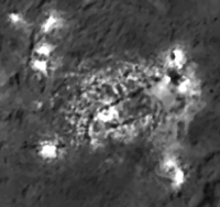
|
I could say I'm hopeful that the area at the far right in the survey orbit image is evidence for the 'haze' that disappears in the HAMO image but I think what we are seeing is more related to Dawn being closer and better able to resolve the spots than anything else. Most likely, any images featuring the supposed 'haze' have not been released, unfortunately...
Posted by: fredk Sep 15 2015, 04:13 PM
It looks very much like the longer-exposure image was used for the smaller spots (as it was for most of the new image). Only the largest spots were replaced with the short-exposure image. They may have simply selected by hand which parts of the long-exposure image to replace with the short-exposure image, or perhaps used some semi-automatic selection method.
We really can't say much from this new image and have to wait until we see the original two frames.
Posted by: Bill Harris Sep 15 2015, 05:47 PM
As I said in the caption to the Comparative images of the two timeframes:
Although the earlier SO image is less clear, similar features can be spotted on both images and over the time span it appears that no significant changes have taken place. Note that the pair of spots on the Eastern side are less prominent in the SO image than in the HAMO image. It may well be that this pair of spots shows decreased activity in the later image, but it might be that this is simply an artifact of NASA compositing the image...
https://univ.smugmug.com/Dawn-Mission/Ceres/i-LTCgGvr/0/O/PIA19889--HAMO--res2x-%2B-PIA19579--SO-11--compar.png
And looking closely at the floor of Occator in the HAMO image, I can say that there has been no obvious changes in the 9June to 21Aug time period, although this has been a very active area.
--Bill
Posted by: ZLD Sep 16 2015, 01:59 AM
Processed enlargement of http://photojournal.jpl.nasa.gov/catalog/PIA19894.
http://i.imgur.com/p4jD7m8.png
Imaging map:
http://i.imgur.com/N9wMb2V.png
Posted by: MarsInMyLifetime Sep 16 2015, 04:10 AM
This linear structure from that image seems to have a depression along part of its ridge line. It appears to be due to subsidence of whatever material formed the dike in the first place.
|
Posted by: bsharp Sep 16 2015, 09:27 AM
|
|
In the context of SO34 (http://photojournal.jpl.nasa.gov/catalog/PIA19603), it is a part of a ridge, but it even looks as if it could be the central peak of a much wider/less obvious crater. You will have to rotate HAMO16 90 deg counterclockwise to get the same perspective.
ZLD: could you please add SO34 to your awesome map?
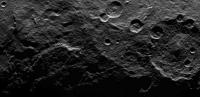
|
EDIT: I almost forgot, this is also visible in a different lightning in SO43 (http://photojournal.jpl.nasa.gov/catalog/PIA19616). The flowage features from the crater on the right ridge are more obvious here.
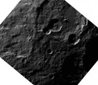
|
Posted by: Habukaz Sep 16 2015, 12:18 PM
In your enlarged version, it looks very obvious that there are boulders on the floor of the young, intriguing crater; but in the original image, it just barely looks that way. Hm.
Posted by: ZLD Sep 16 2015, 01:40 PM
bsharp: I'll try to include this in today's map. The Dawn releases have pretty commonly been occuring between 11h00 and 12h00 CST.
Habukaz: As for the magically appearing boulders, I wouldn't rule out the possibility of noise but most of the released HAMO images seem to be, for whatever reason, just slightly out of focus to begin with so who knows.
Posted by: Habukaz Sep 16 2015, 02:42 PM
I just had a look at the TIFF file, and it seems that JPEG was the culprit. For such fine details, even light JPEG compression can make a big difference, apparently. Lesson learnt.
Pretty sure now that the boulders are real. I hadn't noticed boulders earlier, though I had only been looking at the JPEGs. I can see boulder-like structures in HAMO #6 as well now.
Posted by: Bill Harris Sep 16 2015, 02:51 PM
There is so much happening in HO16. An apparent slumpage feature to the west, a mantling terrain flowage feature to the east and on the upper side, a conical hill with a central pit.
And we are getting the "Meh" HAMOs from last month. Think of what the reaallly good stuff shows!!!!
--Bill
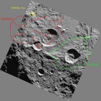
|
Posted by: ZLD Sep 16 2015, 03:34 PM
No kidding Bill. I think at this point, while the brights spots are tantalizing, Haulani is currently more intriguing to me. Really looking forward to that HAMO image. I will again hope that's what we'll be getting today but I'm not going to hold my breath (not interested in asphyxiating myself really).
Also, the conical hill you noted in your image Bill, there are several others in the area and to me it would seem that they may be related to ancient central crater peaks that have lingered longer than the crater rims.
Posted by: charborob Sep 16 2015, 04:24 PM
Spectacular slump feature in HAMO17:

|
(enlarged 3x)
Posted by: ZLD Sep 16 2015, 04:35 PM
Processed enlargement of http://photojournal.jpl.nasa.gov/catalog/PIA19895.
http://i.imgur.com/qOWV39J.png
Now that we've seen an appreciable number of slumped soil in HAMO, this one seems particularly smooth, with an obvious exception that it was already unique. It seems almost like it just melted away like a lava flow rather than the other seemingly stepped mass wasting at other sites.
Imaging map:
http://i.imgur.com/eTiwQEB.png
Posted by: alan Sep 16 2015, 05:02 PM
|
|
(enlarged 3x)
Seen previously with different lighting in HAMO4
http://www.unmannedspaceflight.com/index.php?showtopic=8077&view=findpost&p=225665
http://photojournal.jpl.nasa.gov/jpeg/PIA19635.jpg
Posted by: ZLD Sep 16 2015, 07:45 PM
Quick tweened animation between the slump in HAMO 4 and HAMO 17.
http://i.imgur.com/nagvv3t.gif
(click to animate)
Far more complex than one lighting angle would suggest, that's for sure.
Posted by: Bill Harris Sep 16 2015, 08:10 PM
ZLD--
The White Spots are interesting, but I think that are an analogue to Mercury's Hollows, but perhaps with a unique Cerean twist. The "flowages" and "slumpages" and "muted terrain" are going to subtly be the major landscape processes. And the closer we are able to look the more we see.
Alan--
Yes! And remember the "HO-4" slump is some 20 km longxwide, and even by Terrestrial standards it would be a major continental catastrophe.
I have a new comparative image set of it in the Ceres Gallery.
https://univ.smugmug.com/Dawn-Mission/Ceres
--Bill
Posted by: JohnVV Sep 17 2015, 12:35 AM
a few rendered images of the mesh of the slump in HAMO4
top left area in the first image -
http://imgbox.com/wteB3Wag http://imgbox.com/7jEZaPys http://imgbox.com/LkzsVVA0 http://imgbox.com/lNXKNaWJ http://imgbox.com/28ETVRTn http://imgbox.com/KhHP1sxj http://imgbox.com/deQKTpc8 http://imgbox.com/yYeTfFd8 http://imgbox.com/F3e3cW9n http://imgbox.com/vTcDQ96r
Posted by: Daniele_bianchino_Italy Sep 18 2015, 12:28 AM
This is a domes or craters? My eyes confused. .

|
Posted by: volcanopele Sep 18 2015, 12:31 AM
Sunlight's coming from the right, so those are craters.
Posted by: JohnVV Sep 18 2015, 02:40 AM
those are two small craters on the slope of the spill
because this area is raised ABOVE things ,there is a bit of an optical illusion .
using the image as a texture

|
rendered just the mesh ( sun in same spot )

|
Posted by: Daniele_bianchino_Italy Sep 18 2015, 04:46 AM
Many Thanks!
Posted by: Bill Harris Sep 18 2015, 08:34 AM
That flowage area looks a bit flat (relief)-- wonder how it would look with 3x-5x vertical exaggeration?
--Bill
Posted by: ZLD Sep 18 2015, 02:11 PM
Processed enlargement of http://photojournal.jpl.nasa.gov/catalog/PIA19896.
http://i.imgur.com/agQscCy.png
-----
Imaging map
http://i.imgur.com/qMxoifj.png
Posted by: ZLD Sep 18 2015, 04:42 PM
Processed enlargement of http://photojournal.jpl.nasa.gov/catalog/PIA19897.
http://i.imgur.com/6pK3GU0.png
-----
Imaging location map
http://i.imgur.com/sucCtXH.png
Posted by: alan Sep 18 2015, 06:12 PM
Is it my imagination or does it look like something flowed into the large crater on the lower right?
Posted by: MarsInMyLifetime Sep 18 2015, 06:21 PM
Seen in PIA 19616, http://photojournal.jpl.nasa.gov/jpegMod/PIA19616_modest.jpg, it could have been a rille. In this closer view, it certainly seems to originate from a hilltop and represent the meandering nature of a stream. But it is also highly degraded. I think an elevation map is needed to make sure it is not "flowing uphill" which would negate a flow of anything.
Posted by: ZLD Sep 18 2015, 06:25 PM
Could be but it's difficult to say at this scale. In the vicinity is a lot of deep cracks that have similar appearances to this.
Posted by: Holder of the Two Leashes Sep 18 2015, 06:43 PM
Seems there was a bit of a hiccup in imaging back on the 13th. From the mission status page ...
Assuming nothing further happens, the particular terrain that wasn't photographed on this pass will still be imaged five times instead of six. Since I expect they'll be anxious to move on to LAMO on schedule (as will most of us) this looks like a write off of those lost images but probably no big deal. Just hope it was a unique event. In the latest Dawn Journal a situation like this was anticipated ...
Posted by: antipode Sep 18 2015, 11:32 PM
On the right hand side of HAMO 19 there's what looks like a sinuous rille (if I think in Lunar terms).
I can almost convince myself that there's a 'cobra head' like source for some kind of liquid.
P
Posted by: monty python Sep 19 2015, 07:06 AM
yah. When I saw the photo I thought - apollo15 hadley rille. but the processes at work on these bodies could be very diferent and produce similar features
Posted by: Webscientist Sep 19 2015, 08:58 AM
A flyover animation of the conical mountain based on the Shape From Shading Technique with artificial colors (I always keep in mind the Mars-like color of a view obtained from the Hubble Space Telescope):
https://www.youtube.com/watch?v=drwlpqxPa9k
Posted by: Bill Harris Sep 19 2015, 12:00 PM
This is an annotated view of another peculiar slump feature from the PIA19896 HAMO-18 image, which shows an area of mass-wasting with multiple lobes which suggests episodic events. In addition, it shows a peculiar light-toned area in highlighted inYellow with unusual tabular, upturned beds and a downslope terrain with a jumbled and chaotic nature highlighted in Magenta. A fracture zone to the South is highlighted in Blue.
https://univ.smugmug.com/Dawn-Mission/Ceres/i-WKKq94r/0/O/PIA19896--HO-18--orient--annot.png
--Bill
Posted by: JohnVV Sep 19 2015, 08:43 PM
https://www.youtube.com/watch?v=drwlpqxPa9k
you might want to reuploade the vid
is is rather dark and way too contrasty
a screenshot of what i see

|
Posted by: Webscientist Sep 19 2015, 09:06 PM
MP4 recording was not ideal. The quality of each png file is of course better. I will try avi, next time.
MP4 recording took about 7 hours with my computer:lol: then wmv... How long would it take for png's?
Thanks for the feed back and the advice John!
Posted by: JohnVV Sep 20 2015, 03:54 AM
MP4 recording took about 7 hours with my computer:lol: then wmv... How long would it take for png's?
Thanks for the feed back and the advice John!
without making a huge long post
i have found that using ogv format , though BIG -- no compression , works best and is GPL .
then for uploading it , transcode to mkv to upload to youtube or to vimo
just your normal every day things
i am not sure what software you are using , i use Blender and the engine in Celestia for videos
Also a bit unsure on the software you use to make the heightmap or mesh ( some software outputs a *.ply )
from the video your heightmap looks a bit off
-- they ALL!! will from only using one image and sfs - fact of life
this is what i get from the Aug 25 image "PIA19631"
-- a 8 bit copy of the 32 bit float

|
Posted by: Webscientist Sep 20 2015, 06:07 AM
i have found that using ogv format , though BIG -- no compression , works best and is GPL .
then for uploading it , transcode to mkv to upload to youtube or to vimo
just your normal every day things
i am not sure what software you are using , i use Blender and the engine in Celestia for videos
Also a bit unsure on the software you use to make the heightmap or mesh ( some software outputs a *.ply )
from the video your heightmap looks a bit off
-- they ALL!! will from only using one image and sfs - fact of life
this is what i get from the Aug 25 image "PIA19631"
-- a 8 bit copy of the 32 bit float
|
|
Ok!
I use Blender for the topography (displace modifier) and I may need more vertices for a more "precise" rendering of the terrain.
Regarding the heightmap, there is the "arbitrary touch" I admit.
The shadow portion of the conical mountain is not well rendered due to the nature of the Shape From Shading Technique.
I've never used Celestia for a flyover animation. I may try in the future.
Posted by: Ken2 Sep 21 2015, 11:09 PM
Its been a little slow on the Dawn page so I figured Id finally make my Occator impact visualization Ive been campaigning for since the early days.
Hypothesis: binary low angle impact with secondaries (and even a tertiary) see figures:
1. Fig 1: Green is the bigger crater even though its a low angle impact - its not elongated much because it hits the side of the central Occator peak. From the dashed green impact trajectory line it just misses a hill and hits the broadside of the central peak. It looks like a normal crater "splat" signature to me - that has been sitting for awhile and all the expected white (ice) broader curtain dusting has had time to sublimate and darken and only the large deposits remain. The asymmetrical pattern is consistent with hitting a side of a mountain and unevenly spreading out between various bumps in the uneven terrain there.
2. Secondaries trajectories (dashed green triangle region) and impacts at hill tops are all consistent with this impact trajectory and the likely long distance secondary (spotted by someone months ago here) down range of it (see second figure) fits nicely in this range. The spread of secondaries means it is much less likely these are primary body impacts.
Also the fact that the main body hit the peak, means it is not a stretch that pieces of the central peak/ or impact body flung out causing large secondaries in a focused region high areas (hill tops) down range in the impact direction.
3. Fig 1: Crater #2 light orange. Since its trajectory missed the central peak it hit further down range and since it was a low angle impact it made a characteristic trench (with widening black rim shadows visible) and weak crater at the end (see MARs crater example Fig 3). The less intense white debris excavated along the trench and a weak low velocity crater IMO seems to be the cleanest match for this signature.
Of course I may be completely wrong and it may turn out be an ice volcano - but I think it is very unlikely on an 99%+ impact dominated world and it doesn't explain the secondaries and smaller crater.

|

|

|
Posted by: ZLD Sep 22 2015, 02:00 PM
Processed enlargement of http://photojournal.jpl.nasa.gov/catalog/PIA19898.
http://i.imgur.com/F30xC5W.png
This is a a close stereo view paired with HAMO 19. Haven't tried to align them yet however. Is there some extra importance to this location I'm missing that would make this a priority stereo imaging location or was it just an opportunity?
-----
Imaging map
http://i.imgur.com/AW3KmOi.png
Posted by: ZLD Sep 22 2015, 05:48 PM
Processed enlargement of http://photojournal.jpl.nasa.gov/catalog/PIA19899:
http://i.imgur.com/wamX52K.png
This is in a very similar location to the last two images. I had a mosaic made up then PSP crashed as I was saving. I'll see if I can remake it this afternoon.
-----
Imaging location map:
http://i.imgur.com/MJ0RLkY.png
Posted by: bsharp Sep 22 2015, 07:42 PM
Pity, looking forward to that. This is one of the most photographed areas indeed. SO31 (http://photojournal.jpl.nasa.gov/catalog/PIA19600) also provides good context. The "snake" (bottom right) seems to prolong further and follow a similar direction as other features.
Posted by: Bill Harris Sep 22 2015, 11:47 PM
This area is a small sliver crustal plate left over between, the impacts of Urvara and Yalode at longitudes 270 to 300 deg and the unnamed impacts to the south. Even though it is fractured and shattered it is still holding it's own as a highland area with a relief of 5-6000 meter above the datum. I think they are studying it because the grazing incidence of the sunlight exaggerates the appearance of the relief.
We'll see what comes of it.
--Bill
Posted by: ZLD Sep 23 2015, 07:09 PM
Processed enlargement of http://photojournal.jpl.nasa.gov/catalog/PIA19900:
http://i.imgur.com/r5DNhVV.png
This image focuses on the same region as the previous 3 releases.
Here is a 4 frame mosaic with includes the latest release:
http://i.imgur.com/pOq9kxw.png
Imaging location map:
http://i.imgur.com/0HVetGp.png
I had a large error in the placement of HAMO 20 that has been corrected int his map. I don't think its quite correct still but close enough.
Posted by: bsharp Sep 23 2015, 09:20 PM
Nice job! As Bill says, there are funky effects from the lightning. This feature stands out a little, plenty of deformed microcraters? Pits? What's going on?

|
It's at the bottom right of HAMO20 or center right in the mosaic
Posted by: charborob Sep 23 2015, 09:34 PM
Cluster of secondaries?
Posted by: ZLD Sep 23 2015, 09:56 PM
That's kinda what I would imagine from something small, breaking up after hitting the roche limit at a somewhat low relative speed and making a short decent before impacting.
Posted by: JohnVV Sep 26 2015, 11:48 PM
Dawn HAMO Image 24
http://photojournal.jpl.nasa.gov/jpeg/PIA19902.jpg
and a few renders at a low altitude
-- textured, then shaded mesh
http://imgbox.com/8fd4zML5 http://imgbox.com/hc7wJMj8 http://imgbox.com/zLpFn96j http://imgbox.com/wsSjDuNR
Posted by: nprev Sep 27 2015, 12:51 AM
Love your renderings, John. Extremely useful.
Posted by: dvandorn Sep 27 2015, 04:48 PM
Agreed -- they show exactly how thick some of these draping units actually are, especially where they pile up against the underlying terrain. In the right-most image, in particular, that ridge looks like it could rise up 500 meters or more above the surface it overlays.
-the other Doug
Posted by: JohnVV Sep 27 2015, 05:14 PM
you do need to be a bit careful on heights
the process i use removes all REAL height info but i end up with RELATIVE heights ( mostly)
if something looks to be twice as tall as something else, it likely is about twice as tall BUT not 500M taller
i can make BAD looking height maps with some what accurate height info ( dose NOT render well and " looks like c??p" )
or
a GOOD looking heightmap but with only relative height information
Posted by: JohnVV Sep 28 2015, 10:53 PM
Dawn HAMO Image 25
http://dawn.jpl.nasa.gov/multimedia/images/image-detail.html?id=PIA19903
and a few low angle images
http://imgbox.com/ryhuLmAz http://imgbox.com/wu2rJ2Kp http://imgbox.com/4CE4Yvc6
here is a link to the 16 bit heightmap i used
https://drive.google.com/file/d/0B6ZYAd08tZL-VXdRSGZXcHhnSG8/view?usp=sharing
JUST the 16 bit map and a README ( with short instructions)

|
this is a 2 meg tif image
VS. a 110 meg mesh
or a 150 meg .blend file
Posted by: djellison Sep 28 2015, 11:34 PM
What are you using to do the SFS?
Posted by: JohnVV Sep 29 2015, 12:07 AM
for the sfs
i do not have a license for Matlab so i can not use "SIRFS_release1.5"
but
there is a old "Carlotto.m" but that needs to be ran through ISIS3's "dstripe" TWICE and a highpass ran on it

|
i mix that output with the Mini_sfs ( minimization) code from the paper
"Derivation of surface topography and terrain parameters from single satellite image using shape-from-shading technique"."
i would be using the sfs in the NGT's "PhotometryTK" but i am having a boost and python issue with stereopipeline and Vision Workbench and a isis3 SEG fault in PhotometryTK
-- " fun" coding issues "ha ha ha ... "
Posted by: JohnVV Sep 29 2015, 11:49 PM
Dawn HAMO Image 26
http://dawn.jpl.nasa.gov/multimedia/images/image-detail.html?id=PIA19904
low angle set of images ( 1920x1080 )
http://imgbox.com/2AcZFnZd http://imgbox.com/NQwxmNEh http://imgbox.com/UnR6k1ZQ http://imgbox.com/wzmBv8W4 http://imgbox.com/fwrRpbZ1
http://imgbox.com/gbd4Fdgk http://imgbox.com/YZ0dCZrp http://imgbox.com/7pFf8k3c http://imgbox.com/hS9Cy44X http://imgbox.com/de7iTItA
a really neat looking hex crater
Posted by: ZLD Sep 30 2015, 03:20 PM
Four updates here.
Processed enlargement of http://photojournal.jpl.nasa.gov/catalog/PIA19901:
http://i.imgur.com/Im30wPY.png
Processed enlargement of http://photojournal.jpl.nasa.gov/catalog/PIA19902:
http://i.imgur.com/x6T3UZk.png
Processed enlargement of http://photojournal.jpl.nasa.gov/catalog/PIA19903:
http://i.imgur.com/44mJ2ZX.png
Processed enlargement of http://photojournal.jpl.nasa.gov/catalog/PIA19904:
http://i.imgur.com/6RHhOqb.png
-----
I probably won't have time to update the imaging map until this weekend at the earliest.
Posted by: Bill Harris Sep 30 2015, 03:50 PM
New Mapping images today:
http://photojournal.jpl.nasa.gov/keywords/dp
Good luck. I still haven't found the loc of HO-23 yet, I suspect it is in the distorted N or S Polar areas and nothing in the SO imagery has popped out.
HO-24 overlaps HO-8.
HO-25 is NE of Toharu (ref: SO-12,15,32) and HO-26 is Fejokoo (ref: SO-10,19).
--Bill
Posted by: ZLD Sep 30 2015, 04:00 PM
H23 is in the same location as H19, H20, H21 and H22. You can see the very prominent central peak from H23 very well in H20. H24 is a secondary capture of the same region in H8. H25 is a secondary capture of the region in H6. H26 I haven't yet had the time to location.Probably in the region around Toharu in the south. H26 is Fejokoo.
Posted by: Bill Harris Sep 30 2015, 05:08 PM
Yep, HO-26 is south of Urvara in the general HO-20-21-22-23 area, but on the south polar terminator line and way distorted on a cylindrical projection. Indexed on SO-10 and -19.
--Bill
Posted by: antipode Oct 1 2015, 06:40 AM
Putting this here seemed more logical than revisiting a very old thread.
From JGR: Planets
Thermal stability of ice on Ceres with rough topography
http://onlinelibrary.wiley.com/doi/10.1002/2015JE004887/full
Even the abstract is an interesting little read
P
Posted by: Bill Harris Oct 1 2015, 03:44 PM
Good paper. I believe that we will find that the tectonic framework of Ceres may be dependent on damp silicate crustal plates riding on somewhat drier lower-crustal/upper-mantle units with moister hydrothermal activity poking through that. At least, so goes my initial read on the compositional and topo data seen by peeking over the shoulders of others.
--Bill
Posted by: alan Oct 1 2015, 03:57 PM
http://photojournal.jpl.nasa.gov/catalog/PIA19975
and a http://photojournal.jpl.nasa.gov/catalog/PIA19977
Posted by: JohnVV Oct 2 2015, 12:56 AM
HAMO 27 image rendered at a low angle
-- 8 bit copy of the heightmap
http://imgbox.com/c1HDzQGz
http://imgbox.com/Fm7TJR2u http://imgbox.com/FDArBliK http://imgbox.com/YSNiSSKm
http://imgbox.com/8mszwuT0 http://imgbox.com/QaTxYFES http://imgbox.com/r50mDfds
Posted by: JohnVV Oct 2 2015, 02:43 AM
HAMO 28
-- rendered at a low angle
with the solar angle so low this makes making a heightmap and rendering a bit harder
http://imgbox.com/JjwLjrpo
http://imgbox.com/22AgUECA http://imgbox.com/W8TDGFMD http://imgbox.com/8xsDkdts http://imgbox.com/nVUlC4ax
http://imgbox.com/iAzdOP5y http://imgbox.com/FnDkZzX8 http://imgbox.com/g2ZbINGI http://imgbox.com/nFlbKtPL
Posted by: JohnVV Oct 2 2015, 08:59 PM
HAMO 29 has what looks to me as a disk read/write error
but............... one never knows

|
some close ups of the odd part of the image
http://imgbox.com/AcPhv9nU http://imgbox.com/Nlvyc7H3 http://imgbox.com/KEPY2xL9 http://imgbox.com/kxdKTQ7Q
could be a landslide ?
http://imgbox.com/hI3vskuk http://imgbox.com/kvathxdt
Posted by: ZLD Oct 2 2015, 09:18 PM
Could you point out what you see as an error? To me, this looks relatively unchanged from previous views of this area.
Posted by: Gladstoner Oct 2 2015, 10:00 PM
The 'read/write error' ( ) looks like a crater rim slump that 'bit off' more than usual. There may have been a pre-existing weakness along that straight line.
Posted by: Bill Harris Oct 2 2015, 10:14 PM
I don't understand, either.
The previous view was HO-5, but this pass has that peculiar crater more centered in the frame and is not a Nadir shot, so the perspective is different. I don't see structural changes between HO-5 and HO-29.
The feature is looking more like an evolving caldera and less like an impact crater.
And these polygonal crater have caught the attention of the Dawn team:
"The irregular shapes of craters on Ceres are especially interesting..." said Carol Raymond, Dawn's deputy principal investigator. "They are very different from the bowl-shaped craters on Vesta."
Read more at: http://phys.org/news/2015-10-dawn-team-insights-ceres.html#jCp
--Bill
Posted by: Ken2 Oct 3 2015, 12:07 AM
Hypothesis: binary low angle impact with secondaries (and even a tertiary) see figures:
1. Fig 1: Green is the bigger crater even though its a low angle impact - its not elongated much because it hits the side of the central Occator peak. From the dashed green impact trajectory line it just misses a hill and hits the broadside of the central peak. It looks like a normal crater "splat" signature to me - that has been sitting for awhile and all the expected white (ice) broader curtain dusting has had time to sublimate and darken and only the large deposits remain. The asymmetrical pattern is consistent with hitting a side of a mountain and unevenly spreading out between various bumps in the uneven terrain there.
2. Secondaries trajectories (dashed green triangle region) and impacts at hill tops are all consistent with this impact trajectory and the likely long distance secondary (spotted by someone months ago here) down range of it (see second figure) fits nicely in this range. The spread of secondaries means it is much less likely these are primary body impacts.
Also the fact that the main body hit the peak, means it is not a stretch that pieces of the central peak/ or impact body flung out causing large secondaries in a focused region high areas (hill tops) down range in the impact direction.
3. Fig 1: Crater #2 light orange. Since its trajectory missed the central peak it hit further down range and since it was a low angle impact it made a characteristic trench (with widening black rim shadows visible) and weak crater at the end (see MARs crater example Fig 3). The less intense white debris excavated along the trench and a weak low velocity crater IMO seems to be the cleanest match for this signature.
Of course I may be completely wrong and it may turn out be an ice volcano - but I think it is very unlikely on an 99%+ impact dominated world and it doesn't explain the secondaries and smaller crater.
|
|
|
|
|
|
The color map recently released adds weight to the Occator shallow impact hypothesis.

|
Posted by: Bill Harris Oct 6 2015, 10:53 AM
I'm having a look at the many polygonal craters we see on Ceres. What sort of analytic techniques are used nowadays? The usual technique I'm used to is "rose" or "rosette" diagrams for looking at the orientations of the walls (facets). Along with other linear features, such as lineations, floor-fill fractures and the odd linear central peak we see.
What is a good current (and maybe free) plotting software for the rose diagrams? Years ago we used ISM, "Interactive Surface Modeling", an ESRI product, but it was a big server-hosted program.
And do we know of current "polygonal crater" references? The recent work appears to be solely by "T Öhman, et al", and of course the classic work is by Baldwin, et al.
--Bill
Posted by: ZLD Oct 7 2015, 04:41 AM
Processed enlargement of http://photojournal.jpl.nasa.gov/catalog/PIA19905:
http://i.imgur.com/hAyE5Mr.png
Processed enlargement of http://photojournal.jpl.nasa.gov/catalog/PIA19906:
http://i.imgur.com/IVRLsqN.png
Processed enlargement of http://photojournal.jpl.nasa.gov/catalog/PIA19907:
http://i.imgur.com/4k4nwzA.png
Processed enlargement of http://photojournal.jpl.nasa.gov/catalog/PIA19908:
http://i.imgur.com/gOUcHcu.png
Processed enlargement of http://photojournal.jpl.nasa.gov/catalog/PIA19909:
http://i.imgur.com/9nVspCA.png
Imaging location map:
http://i.imgur.com/WiONPVl.png
Oxo morph from HAMO 5 --> HAMO29:
http://i.imgur.com/HGvKJOt.gif
(click to animate)
Posted by: Bill Harris Oct 7 2015, 12:08 PM
Caldera named Oxo crater:
https://univ.smugmug.com/Dawn-Mission/Ceres/i-72PTKVZ/0/O/PIA19907--HO-29--montage-annot.png
What a strange world.
--Bill
Posted by: ZLD Oct 7 2015, 01:57 PM
Thats continued to be my impression as well Bill. If you watch the animation I posted above, I think the crater is much deeper than would be initially apparent.
Here is a rough outline of the central pit I see:

|
Would still really like to see Haulani in HAMO. Instead we keep getting the same areas filled in which is great but they are also relatively benign as far as what makes Ceres unique.
Posted by: Bill Harris Oct 7 2015, 02:14 PM
I did some name-updating to my index map and this feature has been named Oxo.
I'd love to see a HAMO of Haulani also, but I suspect that it-- and a couple of other areas-- are so jaw-dropping that they are holding some areas back for Major Announcements. You have to wear a PT Barnum hat in planetary science sometimes. Spot5/Occator and Tall Mtn had to go public, they got a lot of Press.
But nevernomind. We've gotten spectacular crumbs.
--Bill
Posted by: alan Oct 7 2015, 03:19 PM
Something volatile below the surface that started vaporizing when the impact removed most of its cover?
ETA: the white patches near the lower right corner of the scarp, could they be left by brine flowing from the base of the cliff?
Posted by: Habukaz Oct 7 2015, 03:19 PM
Not only Haulani, but Dantu as well. It has some interesting patterns of the bright stuff.
Posted by: ZLD Oct 7 2015, 06:07 PM
Spectacular crumbs indeed. I guess I'm jaded by the strong desire of the New Horizons team to frequently and excitedly share results. Does anyone know of a PDF of a 'Dawn Data Management Plan' for the Ceres phase? Can't seem to find a release schedule anywhere.
Posted by: Bill Harris Oct 7 2015, 06:21 PM
In the 1960's one Big debate was the Impact or Volcanic origin of Lunar craters. As it turned out, many--if not most-- craters are impact craters. This is an old debate, but what we are seeing here may be a link to the non-impact origin of some--if not many-- of these features. But still, there is strong evidence for a volcanic origin of many craters or calderas. And/or volcanism as a secondary modifier of impact craters. Read up on "polygonal craters" and "polygonal calderas". Read up also on the Lunar crater Alphonsus-- the poster-child of the impact-caldera debate.
My thoughts are that the light-toned material is related to zones of hydrothermally-deposited salt which underlies a dark rocky regolith and is exposed by some impacts, anf the shocks of the impact may reactivate the hot-water plumbing. Some regions-- like Occator, Oxo, Haulani and Dantu-- have active zones of hydrothermal vents where the salts are being actively deposited.
The HAMO phase is giving us a good idea of where to look next and the LAMO phase will let us sort out all the chicken feet from the duck feet on our tabletop of Puzzle Pieces.
--Bill
ps--
HO-32 is Toharu, SO-12, 15 and HO-7
--b
Posted by: ZLD Oct 7 2015, 06:42 PM
Responding to myself here:
The Ceres data release schedule is half that at Vesta. Three months after the end of Survey Orbit, there's supposed to be an EDR release. That should take place at the end of this month or early next if that is still the case.
Relevant table:

|
This was buried in the Spring book overview of the mission. http://link.springer.com/chapter/10.1007%2F978-1-4614-4903-4_17
Posted by: stevesliva Oct 7 2015, 08:09 PM
Semantically, has "crater" taken on a meaning as nonvolcanic while "caldera" or (patera) is used for volcanic? Seems like as soon as a non-impact origin is considered, people start using terms other than crater.
Posted by: ZLD Oct 7 2015, 10:09 PM
The central pit of a volcano is still a form of crater but for clarity, it may be better to differentiate with terms when possible, especially when discussing bodies heavily covered with impact craters. In general use, the term 'crater' has been relegated to mean impact crater I think.
Posted by: Bill Harris Oct 8 2015, 12:03 AM
'Tis a semantic quagmire. Or can be.
I _tend_ to think in terms of crater/impact crater and caldera/volcanic crater. "Crater" ("cup" in Latin) does have the context of being an impact structure. "Caldera" ("cooking pot" in Spanish) has the context of being volcanic. In context I tend to lapse into talking about volcanic craters and sometimes just craters when the context is clear.
And to further confuse things, we have maar structures, which are a bowl-shape caused by a different kaboom.
Oy.
--Bill
Posted by: ZLD Oct 8 2015, 12:07 AM
Processed enlargement of http://photojournal.jpl.nasa.gov/catalog/PIA19910:
http://i.imgur.com/ytKvJik.png
Imaging location map:
http://i.imgur.com/y3guyOD.png
Posted by: ngunn Oct 8 2015, 07:05 AM
Thanks for posting these so regularly. I have one small suggestion. Could the new addition be highlighted in some way on the location map, perhaps in a different colour? With so many on there now, often overlapping, it's getting harder to find the new one each time.
Posted by: Bill Harris Oct 8 2015, 11:55 AM
I've finally re-reviewed and posted the Preliminary Geomorphology of Occator crater.
This is the preliminary assessment of the geological conditions of Occator crater showing the crater rim and mass-wasting processes, the floor and volcanic flows and the hydrothermal vents and deposits. All. of course, subject to revision and rethinking.
https://univ.smugmug.com/Dawn-Mission/Ceres/i-CmsS2zS/0/O/PIA19889--occator--geomorphology--v1.png
--Bill
Posted by: ZLD Oct 8 2015, 01:42 PM
@ngunn: Glad people are getting use from the map. I'll highlight the new additions in yellow starting today; good idea!. For past ones, you could load up the previous map in one tab and the new map in another tab and switch back and forth and the new addition(s) will be blinking.
Posted by: ZLD Oct 8 2015, 06:47 PM
Processed enlargement of http://photojournal.jpl.nasa.gov/catalog/PIA19971:
http://i.imgur.com/vFcQjhb.png
Imaging location map:
http://i.imgur.com/KqBBnHA.png
Got a tip on this one from Landru79. Thanks again!
Posted by: Bill Harris Oct 8 2015, 06:53 PM
Today's offering, HO-33, is just a little crumb stuck up way north with nothing noteworthy (except for a slumpage half in the shadows). Couldn't even find related SO- or HO- images for it. But again Team, thanks for sharing!
A color-coded index map:
--Bill

|
Posted by: ZLD Oct 8 2015, 07:26 PM
Here's a rough colorization of HAMO 33 from today:
http://i.imgur.com/An13z59.jpg
As I understand it, IR and red have been combined and added to the blue channel and then the green is some sort of albedo map according to the color map description http://photojournal.jpl.nasa.gov/catalog/PIA19977. I've been working on synthesizing a proper green channel from a known blue and red channel for a few months trying to get it as close to correct as possible and this process was used in the image above. Dark pinks are still rendered too orange in the process but it seems mostly reliable in broad use.
Posted by: nprev Oct 8 2015, 11:40 PM
Haven't seen this mentioned: There's gonna be a http://www.ustream.tv/NASAJPL2 tonight (9 Oct/0200 GMT, 8 Oct/1900 PDT) titled "Unveiling Ceres".
EDIT: Starting now.
Posted by: Gladstoner Oct 9 2015, 06:28 PM
Linear valleys featured today:

|
http://photojournal.jpl.nasa.gov/catalog/PIA19972
Posted by: Bill Harris Oct 9 2015, 06:53 PM
The cat-scratches and *poof* from that prominent crateroid are curious.
--Bill
Posted by: ZLD Oct 9 2015, 09:18 PM
Processed enlargement of http://photojournal.jpl.nasa.gov/catalog/PIA19972:
http://i.imgur.com/kXx08ya.png
Imaging location map:
http://i.imgur.com/qL1ZeDc.png
The terrain folding is pretty interesting. Definitely was interested in seeing this in HAMO. Looks like something flowed across the ground and buckled as it began to stall.
Posted by: alan Oct 10 2015, 09:21 PM
EDIT: Starting now.
Thanks for pointing that out, I had missed NASA's announcement of the discovery of water on
Posted by: Bill Harris Oct 11 2015, 01:03 AM
Summary, please, for those who don't do livestream?
--Bill
Posted by: djellison Oct 11 2015, 01:13 AM
If you don't Livestream, do you YouTube?
https://www.youtube.com/watch?v=_G9LudkLWOY
Posted by: FOV Oct 11 2015, 01:14 AM
"Unveiling Ceres" is also a YouTube: https://youtu.be/_G9LudkLWOY
Posted by: JohnVV Oct 11 2015, 07:31 AM
HAMO-34
-- rough remap to orthographic projection to remove camera tilt
-- North UP
http://imgbox.com/PWjE2rTa http://imgbox.com/SSrb347D
Posted by: Bill Harris Oct 13 2015, 03:07 AM
This series of images may trend northward between craters Urvara and Yalode and into the fractured continental terrain south of Occator. The montage will be updated as new images come in. Currently the five images in the montage are HAMO-19, -20, -21, -22 and -34.
https://univ.smugmug.com/Dawn-Mission/Ceres/i-SqmjMvN/0/O/PIA19897--HO-19-20-21-22-34--orient--enh--pano.png
--Bill
Posted by: Landru79 Oct 13 2015, 02:30 PM
Newbie composition/location. I hope no disturb 
Hamo 35 ¿close shot on "Zadeni"?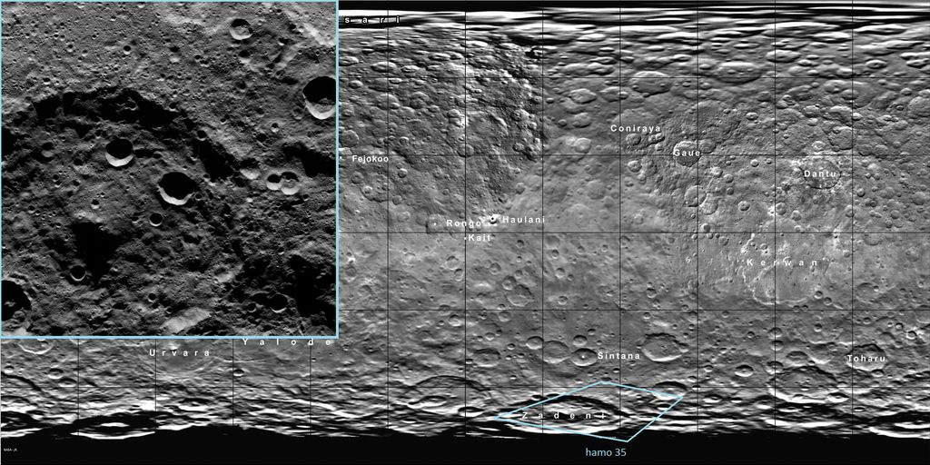
Posted by: Bill Harris Oct 14 2015, 04:38 AM
HO-36 is situated midway between HO-4 and HO-5. Has a nice flowage in the SE corner.
Presented simply as a purty picher:
Area of flowages and slumpages near crater Oxo
Peculiar mass-wasting processes near crater Oxo, which is in an area suspected of seismic and tectonic activity.
https://univ.smugmug.com/Dawn-Mission/Ceres/i-PqzMmcg/0/O/PIA19978--HO-36--orient--enh--pano.png
--Bill
Posted by: Daniele_bianchino_Italy Oct 14 2015, 09:11 AM
Good morning,
someone made a realistic color image of as Ceres appears to the human eye?..Many ThanKS
Posted by: Bill Harris Oct 14 2015, 04:37 PM
Today's HAMO-37 is Oxo crater with a different lighting angle ( HO-5, HO-29, HO-37 series ).
--Bill
Posted by: ZLD Oct 18 2015, 02:40 AM
Overdue update here.
-----------------------------------
Processed enlargements
-----------------------------------
http://photojournal.jpl.nasa.gov/catalog/PIA19973
http://i.imgur.com/NwpQIMJ.png
http://photojournal.jpl.nasa.gov/catalog/PIA19978
http://i.imgur.com/ir9b7YS.png
http://photojournal.jpl.nasa.gov/catalog/PIA19979
http://i.imgur.com/mY2XYqe.png
http://photojournal.jpl.nasa.gov/catalog/PIA19980
http://i.imgur.com/N2t7Oe9.png
http://photojournal.jpl.nasa.gov/catalog/PIA19981
http://i.imgur.com/XiupP5O.png
-------------------------
Imaging location map
-------------------------
http://i.imgur.com/7MmDZ6k.png
Edit: Just realized that when I enabled all the layers, I overlapped some labels. I'll correct this tomorrow.
Posted by: Gladstoner Oct 18 2015, 06:29 AM
Imaging location map
-------------------------
[url=[/url]
Edit: Just realized that when I enabled all the layers, I overlapped some labels. I'll correct this tomorrow.
Thanks much for the effort. It is nice to have an updated index map for the raws.
Posted by: Daniele_bianchino_Italy Oct 18 2015, 10:40 AM
Grazie ZLD : )
Posted by: Bill Harris Oct 18 2015, 02:13 PM
A Crateroid surrounded by Jumbled and Chaotic terrain
This initial image is a 2x-enlarged enhanced image of the northern portion of HAMO-39 and is shown without the usual descriptive annotations. It is an oblique image and has been rotated and cropped to give a better perspective view.
https://univ.smugmug.com/Dawn-Mission/Ceres/i-HLdBV8t/0/O/PIA19981--HO-39--orientN--crop1--res2x--enh3.png
This spot has to be "Where's Waldo" of Cerean locales. The more you look, the more you see.
--Bill
Posted by: Bill Harris Oct 20 2015, 02:03 PM
The current HAMO public image, HO-40, is noteworthy for... nothing. After the formation of the unnamed 100Km crater in the center and subsequent impact cratering this area has lain virtually undisturbed for aeons-- no hydrothermal activity, no tectonic activity and, with the exception of the mass-wasting event from the creation of a 25Km crater on the NW rim, no major slumpages.
This spot is a prime example of an undisturbed area and contrasts very well with the other images in the series across crater Toharu. Good work, Dawn Team.
https://univ.smugmug.com/Dawn-Mission/Ceres/i-xdvXGb2/0/O/PIA19982--HO-40--orient--enh.png
--Bill
Posted by: ZLD Oct 21 2015, 02:51 PM
-----------------------------------
Processed Enlargements
-----------------------------------
http://photojournal.jpl.nasa.gov/catalog/PIA19982
http://i.imgur.com/Jr69W3z.png
http://photojournal.jpl.nasa.gov/catalog/PIA19983
http://i.imgur.com/5YwvnAt.png
-----------------------------------
Imaging location map
-----------------------------------
http://i.imgur.com/1JW5vEe.png
Posted by: ZLD Oct 21 2015, 05:19 PM
----------------------------------------
Processed Enlargement
----------------------------------------
http://photojournal.jpl.nasa.gov/catalog/PIA19984
http://i.imgur.com/kPIfLRK.png
----------------------------------------
Imaging location map
----------------------------------------
http://i.imgur.com/5WMytCm.png
Posted by: JohnVV Oct 21 2015, 07:05 PM
Ceres dose seam to have a over abundance of the hexagon shaped craters .
Posted by: ZLD Oct 22 2015, 05:46 PM
----------------------------------------
Processed Enlargement
----------------------------------------
http://photojournal.jpl.nasa.gov/catalog/PIA19985
http://i.imgur.com/IhuWB7o.png
----------------------------------------
Imaging location map
----------------------------------------
http://i.imgur.com/EeEVGjg.png
Posted by: Bill Harris Oct 23 2015, 09:55 AM
Polygonal craters are a very important structural clue.
What is a good current (and maybe free) plotting software for the rose diagrams? Years ago we used ISM, "Interactive Surface Modeling", an ESRI product, but it was a big server-hosted program.
And do we know of current "polygonal crater" references? The recent work appears to be solely by "T Öhman, et al", and of course the classic work is by Baldwin, et al.
--Bill
I've ended up using a old database template I used to use for joint and fault orientation. Doesn't do much, but it keeps the data in neat rows and columns and outputs rose diagrams.
--Bill
Posted by: Floyd Oct 23 2015, 04:33 PM
I know they are releasing 1 image a day--thus the map coverage is filling up very slowly. Anyone know about how many images they actually take per day? By the end of HAMO aren't they supposed to have about 5-10 images deep coverage of every spot on the globe? So does that mean that they are taking 10 - 30 images /day?
Posted by: Holder of the Two Leashes Oct 23 2015, 05:09 PM
Pictures per day is probably a variable, since they are in a nineteen hour orbit. Besides, they store up everything for days and then transmit it all between mapping cycles, so for a couple of days in a row they don't take any pictures.
In any case, they have recently promised on the mission status page that the upcoming issue of the DAWN Journal will have a detailed recap of HAMO, so you will probably get some good answers in a few days.
The only missed pictures were a few from the third mapping cycle. Except for those, I expect every piece of visible real estate got scrutinized at least six times, with some overlap.
HAMO is about to be over. All the picture taking is done and everything transmitted to earth.
In a little over five hours from now, ion engine two will fire up and DAWN will begin its decent to LAMO.
Posted by: Bill Harris Oct 24 2015, 11:55 AM
Crater Victa--subject of HAMO-44-- now we can see why this 28 Km crater received it's own name.
https://univ.smugmug.com/Dawn-Mission/Ceres/i-PhpVvX3/0/O/PIA19986--HO-44--orient--crop2--res3xt--enh2--victa.png
And a montage of today's HO-45 image and an earlier image showing part of the Samhain Catena, a major tectonic feature south of Occator.
https://univ.smugmug.com/Dawn-Mission/Ceres/i-wjLHwvF/0/O/PIA19984--HO-42%2BHO-45_pano--orient--enh.png
--Bill
Posted by: fredk Oct 26 2015, 09:52 PM
The new Occator mosaic looks cleaner than the previous release:

|
However, it's still a merge of long- and short-exposure images, so interpret with caution...
Edit: Oops, sorry for posting to the wrong thread.
Posted by: ngunn Oct 26 2015, 10:34 PM
And it's still bleached out in the bright areas. We really need to see these locations with a much shorter exposure even if it means the surrounding dirt appears completely black. We're half way to the outer solar system but still snow blind.
Posted by: Bill Harris Oct 27 2015, 01:32 AM
It's snow-white and will look wrong if placed in Zone V, or even Zone VII.
--Bill
Posted by: ZLD Oct 27 2015, 09:18 PM
----------------------------------------
Processed Enlargement
----------------------------------------
http://photojournal.jpl.nasa.gov/catalog/PIA19986
http://i.imgur.com/3vbFujW.png
http://photojournal.jpl.nasa.gov/catalog/PIA19987
http://i.imgur.com/sSunYC1.png
http://photojournal.jpl.nasa.gov/catalog/PIA19988
http://i.imgur.com/daPeiIf.png
----------------------------------------
Imaging location map
----------------------------------------
http://i.imgur.com/twQCnwb.png
Posted by: Bill Harris Oct 28 2015, 02:18 PM
Interesting and apropos for our minor planets:
"Growing the Terrestrial Planets from the Gradual Accumulation of Sub-meter Sized Objects"
www.pnas.org/cgi/doi/10.1073/pnas.1513364112 (may be embargoed)
SwRI presser in Phys.org:
http://phys.org/news/2015-10-scientists-rocky-planets-pebbles.html
--Bill
Posted by: ZLD Oct 28 2015, 06:29 PM
----------------------------------------
Processed Enlargement
----------------------------------------
http://photojournal.jpl.nasa.gov/catalog/PIA19989
http://i.imgur.com/2UwvrCE.png
----------------------------------------
Imaging location map
----------------------------------------
http://i.imgur.com/PZmu22I.png
Posted by: Ken2 Oct 28 2015, 11:33 PM
|
|
However, it's still a merge of long- and short-exposure images, so interpret with caution...
It's quite a bit cleaner - great catch!
In fact it's so much cleaner that I'm going to scrap my previous big binary hypothesis and trench for the lessor spot and go with a single large impact for the main spot and lots of secondaries / or a large impact with a shotgun of associated moonlets/fragments.
Specifically I blew up and sharpened the image (I know artifacts are introduced - but it highlights the key features for visualization). Craters and associated ejecta circles are highlighted in various colors. The purple and orange one's centers are a bit sketchy but it conveys the idea. The green one looks like a separate later dark body impact - though it could be pre existing terrain bordering on a fault line.
now the agonizing seven week wait to LAMO to get the picts we've been waiting for - go Dawn go !
(click to animate)

|
Posted by: ZLD Oct 29 2015, 04:53 PM
----------------------------------------
Processed Enlargement
----------------------------------------
http://photojournal.jpl.nasa.gov/catalog/PIA19990
http://i.imgur.com/Gayy0A5.png
----------------------------------------
Imaging location map
----------------------------------------
http://i.imgur.com/OoqA8Dy.png
Posted by: Holder of the Two Leashes Oct 31 2015, 02:45 AM
The http://dawnblog.jpl.nasa.gov/2015/10/30/dawn-journal-october-30/ is now out with a complete overview of HAMO at Ceres. They took over 6700 pictures since the start of science operations August 17th. So from there to about October 21st they were averaging about a hundred pictures per day.
The most surprising thing for me was they were able to use some readings from the GRaND instrument to deduce what might be the presence of a magnetic field, although that is far from certain.
Posted by: Bill Harris Oct 31 2015, 07:02 AM
And the October Dawn Journal has many new feature names on it's cylindrical projection map. I've updated my Index map, which is good through HAMO-49.
https://univ.smugmug.com/Dawn-Mission/Ceres
https://univ.smugmug.com/Dawn-Mission/Ceres/i-WbVdb3f/2/O/_PIA19625--cyl_map-names--SO_HO--quickview_49.png
--Bill
Posted by: alan Oct 31 2015, 07:59 PM
From one of the AGU abstracts:
https://agu.confex.com/agu/fm15/meetingapp.cgi/Paper/74163
Posted by: Bill Harris Oct 31 2015, 08:42 PM
Whoa. I missed that abstract. "...ammoniated phyllosilicates mixed with other clays, Mg-carbonates..." is the eyebrow-raiser. But not totally unexpected-- some thought is that Ceres originated in the Oort neighborhood and moved downtown, so it could well be a clinker. And we see similarities in surface features on Ceres and Charon.
--Bill
Posted by: Gladstoner Oct 31 2015, 10:02 PM
Ammoniated phyllosilicates.... now that is different.
Plus, the thought of Ceres (and Jupiter trojans) being TNOs is quite intriguing, i.e. we wouldn't have to wait 50 years to sample one.
Posted by: stone Nov 1 2015, 06:29 PM
Plus, the thought of Ceres (and Jupiter trojans) being TNOs is quite intriguing, i.e. we wouldn't have to wait 50 years to sample one.
After 23 years this hypothesis looks to have found a prove.
King T. V. V., Clark R. N., Calvin W. M., Sherman D. M., and Brown
R. H. 1992. Evidence for ammonium-bearing minerals on Ceres.
Science 255:15511553.
Posted by: ngunn Nov 1 2015, 06:49 PM
LPSC abstract for that: https://www.google.co.uk/url?sa=t&rct=j&q=&esrc=s&source=web&cd=6&cad=rja&uact=8&ved=0CDsQFjAFahUKEwj138LV8O_IAhUJgj4KHTjUCyU&url=http%3A%2F%2Fadsabs.harvard.edu%2Ffull%2F1991LPICo.758...31K&usg=AFQjCNH4kDT5GSVDz2GEH9NIx3azKek2HQ
Posted by: monty python Nov 2 2015, 06:54 AM
Hats off and a case of beer to the people who wrote that paper. Amazing.
Posted by: MahFL Nov 2 2015, 11:51 AM
That was made from Earth observations, not the HAMO observations, so it's in the wrong topic ?
Posted by: ngunn Nov 2 2015, 12:22 PM
I don't think so. We're just filling in some historical background for the Dawn observation to show that it wasn't wholly unexpected.
Posted by: ZLD Nov 2 2015, 07:36 PM
----------------------------------------
Processed Enlargement
----------------------------------------
http://photojournal.jpl.nasa.gov/catalog/PIA19991
http://i.imgur.com/CisMl5N.png
http://photojournal.jpl.nasa.gov/catalog/PIA19992
http://i.imgur.com/IlUgMfq.png
----------------------------------------
Imaging location map
----------------------------------------
http://i.imgur.com/hZIdg8R.png
Didn't mention it last time but I've since added all of the most recent official nomenclature to the map. I increased transparency in order of lesser importance / size -- ~25% for the smallest, least important vs 75-100% for largest / most important.
Posted by: antipode Nov 2 2015, 08:12 PM
Some interesting bright exposures on the central peak in HAMO 50.
Unfortunately the geometry of the shot isn't ideal to really see the steep slopes in question.
P
Powered by Invision Power Board (http://www.invisionboard.com)
© Invision Power Services (http://www.invisionpower.com)