Printable Version of Topic
Click here to view this topic in its original format
Unmanned Spaceflight.com _ Dawn _ HAMO
Posted by: Phil Stooke Sep 1 2011, 01:12 PM
According to Dawn (who ought to know) the descent to the next mapping orbit is beginning now.
"NASA_Dawn NASA's Dawn Mission
I'm done with Survey science operations today!! Time for a several-week transfer down to High Altitude Mapping Orbit (HAMO)!!
20 hours ago"
Better pics on the way! Thanks, Dawn team, for the pictures so far. Will we learn of any preliminary nomenclature soon?
Phil
Posted by: mchan Sep 1 2011, 08:17 PM
http://dawn.jpl.nasa.gov/mission/journal_09_01_11.asp on HAMO --
"...they have been able to detect variations in the gravity field that are due to the uneven distribution of mass within the protoplanet. With their improved charts of the waters around Vesta, they plotted the ships course, and it is now under sail. Thrusting with the ion propulsion system began on August 31 at 4:05 p.m. PDT, and this trip to the high altitude mapping orbit will take a month."
Posted by: DrShank Sep 2 2011, 05:55 PM

"NASA_Dawn NASA's Dawn Mission
I'm done with Survey science operations today!! Time for a several-week transfer down to High Altitude Mapping Orbit (HAMO)!!
20 hours ago"
Better pics on the way! Thanks, Dawn team, for the pictures so far. Will we learn of any preliminary nomenclature soon?
Phil
Hi Phil!
Nomenclature work has only just begun. we have been "surveying' the Survey data as it were, simply getting a feel for the geography. Once the coordinate system has been fixed, we will proceed with names. A list of names is ready to go, we just need to identify which features are priority for the first batch of names.
cheers
paul
Posted by: Phil Stooke Sep 2 2011, 06:00 PM
Thanks, Paul.
Phil
Posted by: dilo Sep 3 2011, 07:19 AM
Thanks for updates, Paul!
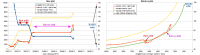
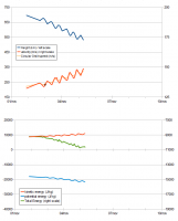
Here below the updated velocity/distance plots, current transfer orbit is clearly elliptical.
|
Posted by: DrShank Sep 3 2011, 04:29 PM
Here below the updated velocity/distance plots, current transfer orbit is clearly elliptical.
|
|
no problem. will try to be more informative as the mission goes on, but i get distracted easily . . .
btw, where are u getting that plot from? I should be monitoring it i suppose!
Posted by: dilo Sep 3 2011, 05:42 PM
I made by myself using http://dawn.jpl.nasa.gov/mission/live_shots.asp from JPL Dawn site. Obviously, not real-time data nor continuous coverage, if you have something better, pls give us! 
Posted by: Sarunia Sep 3 2011, 08:58 PM
First Message: Hello everybody 
Answering dilo:
You can use SPICE data from NAIF: ftp://naif.jpl.nasa.gov/pub/naif/DAWN/kernels/
For example, I product this http://www.youtube.com/watch?v=qWZbcAKXu-s from theses data.
The problem is that you should have some (but little  ) programming skill for using SPICE files.
But the good news is that the NAIF library (see upper node of link) is full of documentations and tools to learn and use it.
But maybe DrShank know a better way ?
Posted by: DrShank Sep 4 2011, 11:36 PM
Answering dilo:
You can use SPICE data from NAIF: ftp://naif.jpl.nasa.gov/pub/naif/DAWN/kernels/
For example, I product this http://www.youtube.com/watch?v=qWZbcAKXu-s from theses data.
The problem is that you should have some (but little
) programming skill for using SPICE files. But the good news is that the NAIF library (see upper node of link) is full of documentations and tools to learn and use it.
But maybe DrShank know a better way ?
not without doing some research into it . . .
Posted by: dilo Sep 5 2011, 11:10 AM
The problem is that you should have some (but little
) programming skill for using SPICE files. But the good news is that the NAIF library (see upper node of link) is full of documentations and tools to learn and use it.
Thanks Sarunia, not an easy task for me (unless someone wants to help on this).
For the moment, I'm still updating from simulator:
|
Posted by: Phil Stooke Sep 5 2011, 03:03 PM
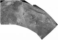
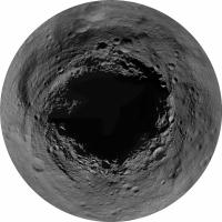
Great pictures recently - not from HAMO yet or even the descent to HAMO, but really giving a taste of what the surface will look like in the weeks to come.
http://dawn.jpl.nasa.gov/multimedia/imageoftheday/archives.asp?month=2011-September
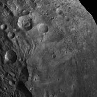
I'm especially interested at the moment in this area from the Sept. 3 release:
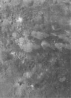
|
Interesting bright patches on a darker surface.
Phil
Posted by: Gsnorgathon Sep 5 2011, 03:36 PM
Dare I say those lobate margins look like flow features? Fun to think about, anyway!
Posted by: Bill Harris Sep 6 2011, 10:22 AM
> I'm especially interested at the moment in this area from the Sept. 3 release:
And why does this crater have an eccentric fill on the floor?
What a peculiar little world.
|
Posted by: DrShank Sep 6 2011, 01:19 PM
The Dawn team could not agree more!
as far as those bright and dark splotches, we are scratching our heads too. they do not seem to have much relief at this resolution (we are
still at ~250 meters and will move to HAMO resolution very slowly) but each significant increase in resolution has forced us to rethink some of our previous conclusions! Vesta is not a simple world.
Posted by: Phil Stooke Sep 6 2011, 01:49 PM
The eccentric fill may be a result of a local slope - the fill is horizontal, the crater's tilted. Of course, we need a proper shape model and interior mass distribution model to be sure, but that's my guess.
Phil
Posted by: Bill Harris Sep 6 2011, 03:05 PM
I considered this an, uh, occipital illusion, and briefly discounted a local slope phenomenon since this is not a grossly potato-shaped world, but the local slope phenomenon is likely the most tenable.
Still, ain't Kansas...
--Bill
Posted by: Phil Stooke Sep 6 2011, 03:46 PM
Several of the recent images can be joined to make a rough mosaic - the first one (left end) in its raw form and the rest distorted to fit it, very uncontrolled.
Phil
|
Posted by: pablogm1024 Sep 7 2011, 06:18 PM
Phil
Hi Phil,
First of all, great job at mosaicking. Second, I just would like to point out that the dark patch south east of the snowman (and including part of the middle crater) are the region formerly known as Olbers. This is the kind of surprises the Vesta holds for us.
We hope to see these mysteries resolved soon!
Regards
Posted by: nprev Sep 8 2011, 04:06 AM
 ...again. (That's why I've been hooked on UMSF since Mariner 9...)
Never gets old, not a bit. We NEVER find what we expect, and of course that's why we go.
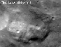
Posted by: Phil Stooke Sep 8 2011, 05:15 PM
Latest picture of the day - an unusual hill:
http://dawn.jpl.nasa.gov/multimedia/imageoftheday/image.asp?date=20110908
But they don't say what's unusual about it, so I'm forced to offer my own theory. It resembles a whale - eye, mouth, fin, tail... head at the top. I think it's the whale from the Hitchhikers Guide to the Galaxy. Of course it could be something boring like a volcano!
Phil
Posted by: PDP8E Sep 8 2011, 05:28 PM
Assuming the magma chamber is not uranium powered - what is the smallest body that can support a volcano?
Wouldn't Vesta be below that limit?
it could be a shadow of an unknown moon ...
Posted by: Phil Stooke Sep 8 2011, 06:36 PM
A whale-shaped moon!
Vesta is well known for its basalt crust, as shown by spectroscopy and the meteorites thought to have come from Vesta. So volcanoes can't be ruled out. The idea of a minimum size for volcanoes may crumble in the face of evidence. That's what Dawn is all about.
Phil
|
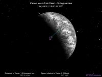
Posted by: dilo Sep 9 2011, 06:31 AM
Dawn is approaaching to final orbit through a complicate set of maneuvers:
|
Happy to see now precise distances indication on simulator (because we are under 1 thousand miles!):
|
Posted by: Tunglere Sep 10 2011, 04:49 PM
A glimpse of Vesta in colour!
http://photojournal.jpl.nasa.gov/catalog/PIA14697
(Alongside a visual/infrared false-colour image of the same bit of terrain.)
I wonder where on Vesta this is.
Posted by: Adam Hurcewicz Sep 12 2011, 09:52 AM
And today picture resized 400% and gamma corection for "best look"
From TIFF.
|
Source:
http://photojournal.jpl.nasa.gov/catalog/PIA14698
http://dawn.jpl.nasa.gov/multimedia/imageoftheday/image.asp?date=20110911
Posted by: dilo Sep 14 2011, 12:32 PM
More and more closer to final orbit...

|
Posted by: dilo Sep 15 2011, 06:19 PM
Simulator didn't update images in the last 14 hours! 

Do someone knows the reason?
Posted by: djellison Sep 15 2011, 06:27 PM
Have you tried sending them a friendly email rather than post an angry face here?
Posted by: dilo Sep 15 2011, 08:13 PM
Good suggestion, Dough (I was hoping someone here was informed, but direct contact is better).
I received a kind answer after only 7 minutes by Judy Counley (Dawn site webmaster) telling that the responsible for simulator is already working on the issue!
Posted by: MarkG Sep 16 2011, 04:52 AM
From TIFF.
|
|
Source:
http://photojournal.jpl.nasa.gov/catalog/PIA14698
http://dawn.jpl.nasa.gov/multimedia/imageoftheday/image.asp?date=20110911
This picture is starting to show some very fine surface detail and texture. I can see why the science pros are tossing out some of their early hypotheses. There is more than enough weird stuff not like anything else seen to make me want to shut up theorizing until I've had a closer look.
Some of the topics for thought on the shaping of Vesta...
Extreme seismic phenomenon from South Pole impact. Contributor to Equatorial grooves? To smaller terrain shapes?
Extreme-but-transient electromagnetic phenomenon. (Impact, CME?)
Large structurally detailed albedo features relatively independent of surface terrain. Impacts of globs of stuff? Exposed dike/craton forms?
Ring collapse onto wobbly Vesta? Unlikely, with many ridge-groove areas non-great-circle. But if the impact sent out heavily-"rayed" debris, could it produce the right terrain on fast-rotating Vesta?
So many questions. More than before Dawn arrived...
Posted by: Bill Harris Sep 16 2011, 11:47 AM
Yes, we'ev got a lot of puzzle-pieces to fit and assemble. The duck-feet look like chicken-feet which are starting to look like talons... 
--Bill
Posted by: Phil Stooke Sep 16 2011, 02:54 PM
Many great new pics at the Photojournal today including this new map:
http://photojournal.jpl.nasa.gov/catalog/PIA14703
including a gridded version. The coordinate system does not match the old one derived from Hubble images, a point that is causing some controversy, but I have little doubt that this will become the official coordinate system eventually. Another image in the new set defines the prime meridian marker:
http://photojournal.jpl.nasa.gov/catalog/PIA14715
Phil
Posted by: Phil Stooke Sep 16 2011, 03:39 PM
This is a montage of frames from the shape model rotation movie also included in this release.
Phil
|
Posted by: stevesliva Sep 16 2011, 05:55 PM
Also cataloged here:
http://dawn.jpl.nasa.gov/multimedia/vesta_dawn_gallery.asp
It's amazing how there are some very distorted ancient basins in the more tropical latitudes. And perhaps another giant basin that creates a gap in the south polar crater "rim." And the grooves aren't equidistant from the center of the southern crater, are they?
Posted by: DrShank Sep 16 2011, 07:19 PM
http://dawn.jpl.nasa.gov/multimedia/vesta_dawn_gallery.asp
It's amazing how there are some very distorted ancient basins in the more tropical latitudes. And perhaps another giant basin that creates a gap in the south polar crater "rim." And the grooves aren't equidistant from the center of the southern crater, are they?
Sharp eyes you have there! we have been discussing both aspects (ancient degraded craters, and the large "Giant basin" as you call it,
for several weeks. Vesta definitely has a history predating the large south polar basin.
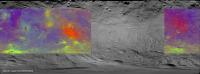
Posted by: Phil Stooke Sep 17 2011, 11:49 PM
http://www.dawn.mps.mpg.de/index.php?id=17&L=1&tx_ttnews%5Btt_news%5D=48&cHash=87b2bf3be6e011932de9d31da5358ace
False color map of Vesta - very nice! It's not the full range of longitudes, only about 240 degrees long, and it doesn't register exactly with the recent base map (different projection), but it is interesting. This barely gets into the south polar depression at its southern edge.
Phil
Posted by: Juramike Sep 18 2011, 12:14 PM
Love it! Sooo cool! How about that massive chasma across the middle? (Blue material in false color)
Posted by: Phil Stooke Sep 18 2011, 03:47 PM
Approximate fit to the previous map.
Phil
|
Posted by: alan Sep 19 2011, 04:12 PM
Could this be a basin?
|
Posted by: Gsnorgathon Sep 19 2011, 05:02 PM
It's clearly a basin. The trick is, what caused it? That wonderful south polar impact threw up a huge amount of ejecta, a fair portion of which would have fallen back to the surface in all sorts of interesting ways. Shaking from the impact doubtless created some interesting structures. Based on what we know so far, Vesta's going to be a tough (and tasty!) nut to crack.
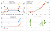
Posted by: dilo Sep 19 2011, 08:59 PM
I had an interesting and very pleasant communication with Dr. Marc Rayman; he explained me that, until few hours ago, Vesta distance reported in the Simulator was based on extrapolated values of distance from asteroid centre, not height. I corrected my database and now is clear that Dawn is very close to HAMO final orbit, both in terms of height and speed (685 km and 135 m/s):

|
update: in the bottom/left plot I changed potential energy (now represented with the correct negative sign) and I added total energy curve (kinetic+potential).
Posted by: pablogm1024 Sep 21 2011, 04:34 PM
Hi Mike,
The blue material in the false color composite seems to be the ejecta blanket from the snowman crater(s). It is known to be remarkably dark and it was named in the past... Olbers Regio.
Cheers.
Posted by: Phil Stooke Sep 21 2011, 05:24 PM
Yes! It's very interesting to overlay the Hubble compositional maps (in Li et al., Icarus 208 (2010) 238251, for instance) over the new maps. Even quite small crater ejecta deposits line up very well. The two 'red' patches (false color) were clearly seen, but mapped as different things (Eucrite and weathered materials). No doubt we'll be getting team publications on this in due course.
Phil
Posted by: belleraphon1 Sep 21 2011, 06:41 PM
In Universe Today is an interview with Prof. Chris Russell and Carol Raymond.
South pole impact feature has been officially named Rhea Silvia after the mother of Romulus and Remus, mthyical mother of the Vestal virgins.
Prof. Chris Russell
We have set ourselves a target to gather everything we know about the south pole impact feature and expect to have a press release from what ever we conclude at the GSA (Geological Society of America) meeting on October 12. We will tell the public what the options are.
We do not have a good analog to Vesta anywhere else in the Solar System and well be studying it very intently.
Sorry for the long url...
http://www.universetoday.com/89093/rhea-silvia-super-mysterious-south-pole-basin-at-vesta-is-named-after-romulus-and-remus-roman-mother/#more-89093
Craig
Posted by: belleraphon1 Sep 21 2011, 06:53 PM
GSA meeting 10/12/11... DAWN session
Dawn at Vesta: Initial Results from the Survey Orbit
http://gsa.confex.com/gsa/2011AM/finalprogram/session_28729.htm
12 presentations!
Craig
Posted by: Paolo Sep 22 2011, 04:18 PM
abstract mostly do not reflect the results of the first weeks in orbit. but there are some exceptions.
I found this intriguing:
from http://gsa.confex.com/gsa/2011AM/finalprogram/abstract_198143.htm
Posted by: Juramike Sep 22 2011, 05:11 PM
And along a similar vein (!):
Both quotes from: http://gsa.confex.com/gsa/2011AM/finalprogram/abstract_196317.htm
Intriguing to think that it could be pure endogenic. (where could all that energy come from?)
Posted by: volcanopele Sep 22 2011, 05:22 PM
It makes some sense. The reason you think everything outside of Rheasilvia is older is because of the plethora of little impact craters that saturate much of the rest of Vesta (except around the snowmen) that you just don't see in it. The age estimate from lower res images like uses craters larger than these little guys and for those you could make the argument that there really aren't that many more outside the big crater than outside.
Perhaps the saturated crater population are secondaries from the big giant impact which basically reset the cratering age of Vesta. Only those secondaries that fell outside the crater which shall not be named survived. The larger craters, like the snowmen, formed after it.
Posted by: Phil Stooke Sep 22 2011, 08:37 PM
When you say Rheasilvia, do you mean Rheasilvia or just Rheasilvia?
Phil
(just kidding!)
Posted by: volcanopele Sep 22 2011, 09:27 PM
Hey, I am just trying to get used to the name... 
Posted by: Phil Stooke Sep 22 2011, 09:32 PM
Well, you're getting lots of experience!
Phil
Posted by: stevesliva Sep 23 2011, 07:24 AM
I wouldn't mind if you called it Rheasliva.
It's got to be an impact crater, right? Not really? "Endogenic?" Would that be like the runaway radioactive-earth-birthing-the-moon hypothesis? Vesta just one day exploded like rotting fruit?
Posted by: Phil Stooke Sep 23 2011, 05:45 PM
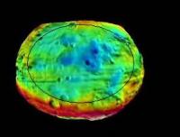
A little thing I've been playing with... the recently released map extended only to about 40 degrees north. I took the northern hemisphere and converted it to a pole-centred view. Many of the image releases including today's extend coverage into the north polar region, which I call 'Philstookia'. Here's the map so far.
Phil
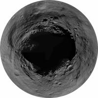
|
Posted by: dilo Sep 23 2011, 10:01 PM
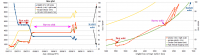
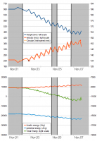
In the last 5 days, Dawn didn't use his engine and remained in a slightly eccentric orbit (665x700 km height):

|
According to last Mission Status, this provisional orbit will allow to set precise orbital parameters and make final orbit adjustment during next week.
UPDATE: According to Dr Marc Rayman private communication, they are now acquiring "Doppler and range data (both to improve the orbit knowledge and to refine the gravity field), and then design, build, and execute a trajectory correction maneuver on Monday night and Tuesday night of next week."
Posted by: DFinfrock Sep 23 2011, 10:42 PM
Philstookia appears to be an immense "abyss".
Posted by: Greg Hullender Sep 24 2011, 03:38 AM
In English, a space probe (like Dawn) is always "she" never "he." So you should say "Dawn didn't use her engine."
Non povo explicare. :-) That's just how it is.
--Greg
Posted by: monty python Sep 24 2011, 07:14 AM
Just looking at Phil's picture.
What if a rapidly spinning Vesta was hit by a huge body early in the asteroid belt formation?
Would you get spiral grooves and terrain jumbled at odd angles?
Brian
Posted by: tanjent Sep 24 2011, 07:59 AM
Indeed, Vesta's midsection does look as if it has been worked on a lathe. But the rotational axis on an actual lathe is maintained by a mechanically rigid piece of machinery. For a pair of free-spinning celestial bodies, it is hard to see how they could maintain just the right distance for several revolutions so to gouge out the grooves without bouncing off, melting, breaking up, merging, etc. The sort of light, plowing, contact that monty is considering is a pretty unstable situation. That said, I don't have a better idea to explain how the grooves got there. I assume some common cause must operate on vesta, phobos, lutezia, maybe even iapetus, but most of the contending stories have holes in them. Let's keep working on it.
Posted by: bk_2 Sep 29 2011, 01:53 AM
If the grooves are not associated with the southern impact, though I find that hard to accept, and predate the modern surface, they must be very old, perhaps from it's formative period. The only mechanism I can propose for parallel grooves is the same one I raised in the case of Phobos viz, intersection with co-planar rings. If in it's formation, Vesta was in an elliptical orbit around a larger body with coplanar circular rings, it could have encountered planar rings edge-on at each periapsis. The global extent of these grooves would indicate that Vesta, unlike Phobos, was not tidally locked at the time.
Posted by: Explorer1 Sep 29 2011, 06:40 PM
Latest journal entry shows that Rheasilvia is indeed the official name of the south pole crater!
Posted by: ilbasso Sep 29 2011, 10:02 PM
My total ignorance of geology is showing, but I could imagine a scenario in which the southern basin impact partially melted the entire surface of Vesta, with the asteroid "ringing" seismically for a while afterward. The concentric grooves in Phil's polar projection remind me of waves that froze as the surface cools.
Again, I am not a geologist...just relaying the impression that I get from that projection.
Posted by: SolarSystemRubble Sep 30 2011, 12:10 AM
Yes, here's the latest Dawn journal:
http://dawn.jpl.nasa.gov/mission/journal_09_27_11.asp
Posted by: Gsnorgathon Sep 30 2011, 04:08 PM
(snip)
Two things: 1) a good deal of the ejecta from the impact might have been molten, so you wouldn't need to melt the whole surface. Just melt some of it and then spray it all over the place. 2) You don't necessarily need anything molten. Seismic shaking from an impact that large on a body that small would be huge. Get some nice resonances going, pile a bunch of fresh ejecta on it, and poof! Troughs and ridges. Sound waves frozen in stone.
Posted by: machi Sep 30 2011, 04:23 PM
Two new stereoscopic images from my blog:
South polar mountain - http://4.bp.blogspot.com/-RSR4n8u4ToI/ToW1Px0wiLI/AAAAAAAAAA0/3ax2V9Ai0v8/s1600/spmce_s.png, http://3.bp.blogspot.com/-YnvbEcnz7C8/ToW1aPJv6hI/AAAAAAAAAA4/b1NrRBqhGMw/s1600/spm3d9z20gsi.png and http://my-favourite-universe.blogspot.com/2011/09/vesta-ve-3d-podruhe.html.
Posted by: dilo Oct 1 2011, 12:57 PM
Beautiful!
Posted by: antipode Oct 1 2011, 01:06 PM
Wow, what an extraordinary structure that has turned out to be!
P
Posted by: Hungry4info Oct 2 2011, 12:47 AM
Is http://dawn.jpl.nasa.gov/multimedia/imageoftheday/image.asp?date=20111001 the first image from HAMO?
Looks splendid either way!
Posted by: volcanopele Oct 2 2011, 01:48 AM
This image was released yesterday:
http://dawn.jpl.nasa.gov/multimedia/dawn_vesta_mapping_orbit.asp
It has a slightly lower pixel scale at 65 meters per pixel.
Posted by: dilo Oct 2 2011, 06:53 AM
Indeed, while yesterday's published image was snapped on Sept,17 from 750km height (based on resolution and according to simulator data), the Volcanopele highlighted one was probably taken the following day, when Dawn reached nominal HAMO height, slightly below 700 km.
Posted by: dilo Oct 3 2011, 01:47 PM
One question: do someone knows updated Vesta size after Dawn exploration?
I guess even preliminary estimates are a lot better than Hubble-based figures but, strangely, I cannot find anything else! (obviously, I am referring to average ellipsoidal 3 axes value)
Posted by: belleraphon1 Oct 3 2011, 04:09 PM
From the EPSC-DPS Joint Meeting 2011 ..
Media release
Dawn at Vesta: Massive mountains, rough surface, and old-young dichotomy in hemispheres
http://www.europlanet-eu.org/outreach/index.php?option=com_content&task=view&id=352&Itemid=41
"NASAs Dawn mission, which has been orbiting Vesta since mid-July, has revealed that the asteroids southern hemisphere boasts one of the largest mountains in the Solar System. Other results show that Vestas surface, viewed at different wavelengths, has striking diversity in its composition particularly around craters. The surface appears to be much rougher than most asteroids in the main asteroid belt. Preliminary results from crater age dates indicate that areas in the southern hemisphere are as young as 1-2 billion years old, much younger than areas in the north. The findings are being presented today at the EPSC-DPS Joint Meeting 2011 in Nantes, France"
This brieifing was webcast live at 6:15am Eastern U.S. and I missed the first 30 minutes.
Good stuff!
Craig
Posted by: volcanopele Oct 3 2011, 04:59 PM
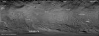
As mentioned in the press release, several names have been approved by the IAU for features that provide the names for mapping quadrants on Vesta. Here is a map identifying those craters (and one hill) :
|
Posted by: ElkGroveDan Oct 3 2011, 05:10 PM
As always, Emily has the answer:
http://www.planetary.org/blog/article/00003207/
Posted by: Phil Stooke Oct 3 2011, 06:16 PM
... or part of the answer. She doesn't give the three axes.
Phil
Posted by: dilo Oct 3 2011, 08:55 PM
Thanks for highlight, ElkGroveDan! And perfect timing, Emily!
Obviously, in the report volume exponent is missed (should be 7,532E+7 cubic km); average radius uncertain should be 850 m.
Posted by: belleraphon1 Oct 3 2011, 11:34 PM
The big thing to me was Dr. Russell's mention of an appreciable iron core, detected though the denity and j2 measurements. So we have a differentiated body.
What a shame they lost the magnetometer to budget. Dr. Russell even mentioned that when a questioner asked what other instruments he would have liked included.
Craig
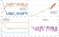
Posted by: dilo Oct 4 2011, 08:33 PM
Update with zoomed scale on last 3 weeks:
|
Height in the last days has been oscillating between 664 and 701 km above nominal 265 km radius.
Posted by: MarkG Oct 7 2011, 04:12 AM
Full inline quote - with image - removed - ADMIN
Looking at that orbital data, I would have to wonder if that is pretty much the closest to a constant-speed, constant-radius, circular orbit Dawn can manage, with Vesta so flattened and asymmetric.
I'm sure the little variations are yielding a picture of the source mass distribution. I can't devolve the gravity figure from the orbit data, doing the math in my head, unless I've had at least 2 beers, and it IS a weeknight. Maybe someone else can help...
Posted by: stevesliva Oct 9 2011, 05:54 PM
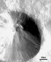
Today's image of the day is pretty fun to look at:
http://dawn.jpl.nasa.gov/multimedia/imageoftheday/image.asp?date=20111009
A lot going on there.
Also-- does anyone know of a good RSS feed to get the image of the day into their reader?
Posted by: monty python Oct 10 2011, 05:26 AM
Yea. It looks like there is a darker (older) layer of material the crater punched into. Is the darker material more loosely consolidated, as it looks to me that the north and south sides of the crater with more dark material slumped, and the pits in the crater bottom are in dark material.
I can't get over how the rays left grooves in the surface. I'm trying to picture in my mind how the impact happened and could do that.
Posted by: Juramike Oct 10 2011, 01:34 PM
Low gravity small body dynamics? The debris flying out gives a trajectory effectively parallel to the ground perhaps and just plows the surface for a really long way?
Posted by: alan Oct 11 2011, 04:36 PM
This paper written a few months before Dawn reached Vesta claims the impact near Vesta's south pole would have caused Vesta's axis to reorient and made some predictions based on this. Are we seeing any of the features they predicted?
http://www.es.ucsc.edu/~fnimmo/website/Isamu_Vesta.pdf
Posted by: stevesliva Oct 11 2011, 05:35 PM
3-D perspective view of the south:
http://dawn.jpl.nasa.gov/multimedia/vesta_south_polar_region.asp
Posted by: charborob Oct 11 2011, 05:53 PM
http://dawn.jpl.nasa.gov/multimedia/vesta_south_polar_region.asp
That image has 1.5x vertical exaggeration (Why? To make it more spectacular?). Here is the same image without vertical exaggeration (contrast enhanced):
|
|
Posted by: chuckclark Oct 11 2011, 06:02 PM
"That image" also flattens the surface. Why? Someone please tell me!
Can you restore the curvature?
Posted by: charborob Oct 11 2011, 08:54 PM
Can you restore the curvature?
The caption of the released image explains it thus:
"This perspective shows the topography, but removes the overall curvature of Vesta, as if the giant asteroid were flat and not rounded. An observer on Vesta would not have a view like this, because the distant features would disappear over the curvature of the horizon."
Someone with the necessary knowledge and appropriate software (that includes some members of this forum) and with access to the original DEM file (that could be more problematic) could produce a view of the surface of Vesta showing the curvature.
Posted by: ngunn Oct 11 2011, 10:22 PM
What a mess. Scientific disinformation in a place you wouldn't expect it. Thanks, members, for pointing it out. (So, can we pruduce the correct version here???)
Posted by: stevesliva Oct 12 2011, 03:24 AM
I would hazard a guess that projecting onto an plane allows for better comparisons to other craters. Except that if you're doing that, you might want to de-exaggerate the height of things, because you're probably comparing to craters on worlds with higher gravity.
Posted by: dilo Oct 12 2011, 04:10 AM
I suspect that realistic version (curved horizon instead of a flat map height) would be less interesting because it would show far less surface and would be very similar to Survey Orbit images, due to limited grid resolution. Things will be different when we will have a complete topography based on HAMO/LAMO data, in this case a virtual tour above surface would be really nice...
Posted by: chuckclark Oct 12 2011, 10:55 AM
Then, perhaps, it was a pragmatic decision taken on limited data or capability (this I could feel better about), rather than a willful aesthetic judgment within a large range of alternatives.
Posted by: Phil Stooke Oct 12 2011, 01:15 PM
Once you have a DEM you can project it any way you like. A DEM of North America might be represented without planetary curvature, in fact it probably would be most often. This one is shown with a plane datum, the next might be done with curvature added. No problem either way. Anyone may prefer one over the other, but don't represent the other as wrong. In time we'll have everything.
Phil
Posted by: stevesliva Oct 14 2011, 12:09 AM
Slew of new stuff:
http://dawn.jpl.nasa.gov/feature_stories/science_team_early_results.asp
http://dawn.jpl.nasa.gov/multimedia/vesta_dawn_gallery.asp
http://dawn.jpl.nasa.gov/multimedia/imageoftheday/image.asp?date=20111012
Some pretty cool slides:
http://dawn.jpl.nasa.gov/multimedia/images/slide5_image.jpg
etc.
Replay of conference here:
http://www.ustream.tv/recorded/17833902
Interesting comments about the troughs.
Posted by: Phil Stooke Oct 17 2011, 06:27 PM
The latest image releases at the Dawn site are much higher resolution - very nice indeed. And it will get even better!
Phil
http://dawn.jpl.nasa.gov/multimedia/imageoftheday/archives.asp?month=2011-October
Posted by: dilo Oct 18 2011, 05:30 AM
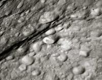
True. But Oct,12 image showing boulders in the crater floor is quite "flat" and deserves an enhanced version:
|
Posted by: pablogm1024 Oct 22 2011, 08:01 PM
Any opinions on the strange half-craters on the recent http://dawn.jpl.nasa.gov/multimedia/imageoftheday/image.asp?date=20111021?
Posted by: stevesliva Oct 22 2011, 09:57 PM
Sure looks like a trough between the two.
Posted by: JTN Oct 22 2011, 11:55 PM
Railway embankment between the two craters?
(Broad gauge, obviously.)
Posted by: monty python Oct 23 2011, 09:14 AM
It's strange isn't it. I see areas on vesta that look like hummocky flow features -like land slide debris - covering the surface. But the half craters look younger than this debris. Could it be that this debris is varying in thickness and distribution so that the the cratering events here punched into only parts of this less consolidated stuff which partially slumped into these craters?
Posted by: bk_2 Oct 24 2011, 07:59 AM
The differing depth of loose ejecta may come into it, the boundary of the slump in the lower crater certainly climbs the slope of the smooth wall to the south. But I think that the angle of incidence of the impact may also have an effect. The floor of the crater is not in the center.
Posted by: Gladstoner Oct 24 2011, 08:50 AM
.
Posted by: machi Oct 24 2011, 10:22 AM
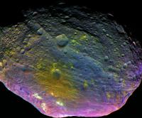
Vesta in almost natural colors (filters centered at 440, 650 and 750 nm).
Two basic images:
http://3.bp.blogspot.com/--9ixB2fzKVM/Tp2JYkpfDFI/AAAAAAAAABM/zqMX67v0R3s/s1600/rc2_b-g-r.png
http://2.bp.blogspot.com/-vjDACRxWBHs/Tp2MnxpgC7I/AAAAAAAAABc/AUlZKFP3n-Y/s1600/rc3_b-g-r_cor-f.png
English captions and 5 other versions are http://my-favourite-universe.blogspot.com/2011/10/vesta-nyni-vysilame-barevne.html.
Original "raw" images are available http://www.sendspace.com/file/5sctxp.
Posted by: pablogm1024 Oct 24 2011, 04:02 PM
Wow, it is very remarkable that, even in natural colors, the ejecta blanket around Oppia has an obviously different shade of gray. Congratulations, Machi, terrific images.
Posted by: Phil Stooke Oct 24 2011, 04:25 PM
... and the full disk one fills in a bit more of the northern hemisphere. Here's my current coverage map of the north pole. Locations may not be very accurate at the terminator but the general appearance is clear.
Phil
|
Posted by: dilo Oct 25 2011, 04:01 PM
Impressive, Phil!
Is grooves spiral structure real? Which is explaination?
I have impression that North pole is hiding something important but I suspect we have to wait looong time before seeing it! 
Posted by: pablogm1024 Oct 25 2011, 04:45 PM
Dilo,
We are all waiting to see what the north pole hides, and according to our calculations we should be able to see most of it by July 2012. We will keep you posted.
Posted by: DrShank Oct 26 2011, 01:04 AM
The spiral pattern is mostly a map projection effect. One of our team has located them and they fit great circles.
Posted by: dilo Oct 26 2011, 05:13 AM
Thanks pablo!
Posted by: alan Oct 27 2011, 04:07 PM
Sounds like they are due to the impacts of orbiting debris.
Posted by: Phil Stooke Oct 27 2011, 07:31 PM
On Iapetus, that process is called on to create a ridge... can it do both?
Phil
Posted by: stevesliva Oct 27 2011, 11:10 PM
If you watch the replay of the presentation that I linked to above, they mention that they are wide, flat-bottomed with steep sides. Certainly don't sound like crater chains. The also believe the ages of the equatorial ones correspond to the Rheasilvia impact and the northern ones to the older southern basin.
Posted by: DrShank Oct 28 2011, 02:50 AM
Impact debris here would form radial or spiral from the center. These are extension cracks formed from several possible sources. Examples include shape change and reorientation. Among others. It's proving difficult to get the exact ages however and we have some numerical models yet to test. Should be interesting!
Posted by: Sarunia Nov 1 2011, 09:47 AM
Two basic images:
English captions and 5 other versions are http://my-favourite-universe.blogspot.com/2011/10/vesta-nyni-vysilame-barevne.html.
Original raw images are available http://www.sendspace.com/file/5sctxp.
Wow ! Great work, and thank you for the raw. How did you get these ?
Posted by: machi Nov 1 2011, 05:43 PM
I haven't much informations about this, I know only, that it's from anonymous source in the Dawn team and it was one-time thing, so we must
wait now for another (raw) data until official release (~ end of year 2012).
Posted by: Sarunia Nov 2 2011, 07:27 PM
wait now for another (raw) data until official release (~ end of year 2012).
Ok. Thanks Machi.
Posted by: dilo Nov 3 2011, 07:32 AM
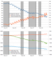
As probably you noticed in the simulator, starting from yesterday Dawn ignited engines and started spiraling toward LAMO:

|
Edit: I updated the plot with last data...
Posted by: Stefan Nov 3 2011, 05:32 PM
wait now for another (raw) data until official release (~ end of year 2012).
Hi Machi,
Our "raw" FC images are certainly not in 8 bit PNG format and we don't produce them in Photoshop, so what you obtained from this anonymous source cannot be described as raw. You had to work with what you had, and you did a fine job producing those color images, but it is beyond me how Emily can present your images on her blog as "nearly natural color".
Stefan.
Posted by: machi Nov 3 2011, 06:35 PM
Hi Stefan
so what you obtained from this anonymous source cannot be described as raw"
Yes, I wrote this inaccurately. What I wanted to write is, that this kind of images
(directly derived from real raw images, with some basic informations about them,
which allow this kind of processing), will not be available until next year.
All published images are without these informations, or they are strongly derived.
Thanks!
Because source images are not in appropriate spectral bands and even more, I have no idea, if these are calibrated or not,
I don't know exactly how close to "natural" these images are. Some http://curator.jsc.nasa.gov/antmet/hed/hed_howget.cfm looks flat for Vesta (in visible),
so I tried similar settings for final images.
For now, few images in "natural" colors was published (http://dawn.jpl.nasa.gov/multimedia/imageoftheday/image.asp?date=20111026) , so
direct comparison is possible (btw these images are using red on 700 nm).
ADMIN FORMATTING EDIT
Posted by: dilo Nov 5 2011, 06:35 AM
Engines cut-off few hours ago, around 530 km height... probably thrust will resume soon:
|
Posted by: Floyd Nov 5 2011, 02:44 PM
What is the target altitude for LAMO? Edit found it:180 km. That low to get gravity field. See Marc Rayman's December 10, 2010 post on the http://dawn.jpl.nasa.gov/mission/journal_12_30_10.asp
Posted by: dilo Nov 6 2011, 07:22 PM
Further update, showing in grey periods with engines off (with very indicative start/end times):
|
Based on a private comunication from Dr Rayman, these thrust interruptions will become more frequent while descending in Vesta's gravity field; main purpose is to re-orient spacecraft in order to transmit radiometric data and establish/transmit new thrust profile.
Edit: updated to Nov,7 18:00 UTC - new engine stop lasting 21 hrs, up to now!
Posted by: dilo Nov 9 2011, 06:03 PM
As anticipated, engine stops are more and more frequent (grey areas in the following updated plot):
|
Not sure about exact on/off times, also because yesterday there was a black-out in the Mystic page connection (maintenance issue?).
Edit: updated plot to Nov.10
Posted by: stevesliva Nov 11 2011, 11:30 PM
Some interesting "simulated true color" images added at the end of October.
http://dawn.jpl.nasa.gov/multimedia/imageoftheday/image.asp?date=20111028
Crazy contrast, really. So I guess that begs the question of whether it's simulated but stretched.
Posted by: Adam Hurcewicz Nov 14 2011, 07:11 AM
Two basic images:
http://3.bp.blogspot.com/--9ixB2fzKVM/Tp2JYkpfDFI/AAAAAAAAABM/zqMX67v0R3s/s1600/rc2_b-g-r.png
http://2.bp.blogspot.com/-vjDACRxWBHs/Tp2MnxpgC7I/AAAAAAAAABc/AUlZKFP3n-Y/s1600/rc3_b-g-r_cor-f.png
English captions and 5 other versions are http://my-favourite-universe.blogspot.com/2011/10/vesta-nyni-vysilame-barevne.html.
Original raw images are available http://www.sendspace.com/file/5sctxp.
Here is my colour version of Vesta. Thanks machi for this raw images.
|
Posted by: Phil Stooke Nov 14 2011, 02:22 PM
Cranking up the saturation on the last image to help reveal the extent of different color units...
|
Phil
Posted by: elakdawalla Nov 14 2011, 07:35 PM
Nice work, Adam! Phil, based on your experience with cranking up the saturation on photos of odd-shaped bodies, do you think that the change in color from north to south is real or does it have more to do with photometric effects?
Posted by: Phil Stooke Nov 14 2011, 09:43 PM
"Phil, based on your experience with cranking up the saturation on photos of odd-shaped bodies, do you think that the change in color from north to south is real or does it have more to do with photometric effects?
Hmmm... on any normal world I'd say I was worried about photometric effects, but we know the south polar terrain is different in this case, so I expect it's some combination of both things.
I think tree ornaments made to look like solar system objects would be a winner. I would buy them...
Phil
Powered by Invision Power Board (http://www.invisionboard.com)
© Invision Power Services (http://www.invisionpower.com)