Printable Version of Topic
Click here to view this topic in its original format
Unmanned Spaceflight.com _ Chang'e program _ Yutu-2 route map
Posted by: Phil Stooke Jan 3 2019, 09:04 PM
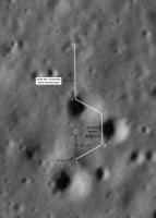
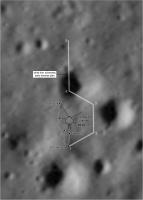
I am setting this up to record activities of Yutu 2, but it looks as if this will be difficult unless we start to see more data releases. As soon as LRO images the lander (and the image is released) I can put a rough background on the map. When descent images of the actual site are released thay can be improved on. Until then this will be very simple.
Let me know if you see any signs of maps or feature names, including in the background of a TV broadcast or on a forum.
Meanwhile, a first contribution. So simple it's almost not necessary, but you have to start somewhere. So rough I am not including a scale yet.
I welcome anyone else's maps as well.
Phil
|
Posted by: Phil Stooke Jan 4 2019, 06:13 PM
A second drive on Jan. 4. By the end of the first lunar day it will seem more useful to have a map!
EDIT: the new location is being called point A. On the previous mission the first stop was X, then each stop for the next few drives were A, B, C and so on.
Phil
|
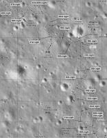
Posted by: Phil Stooke Jan 11 2019, 08:08 AM
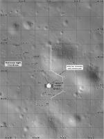
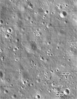
Here's a first crack at a proper route map. They will presumably turn west rather than east as the preliminary (probably pre-landing) plan suggested.
I will deal with scales etc. when I can get to it.
Phil
|
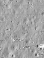
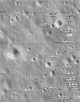
Posted by: Phil Stooke Jan 11 2019, 07:08 PM
Jan. 11 update. I am still working on getting the scale right but Gonetoplaid's scaled image in the other thread will help a lot.
The screenshot of a map - if enlarged - shows the site labels X, A, A', B.
Phil
|
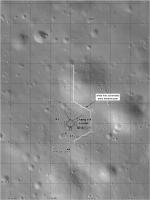
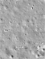
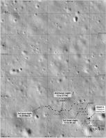
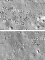
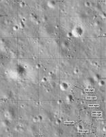
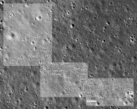
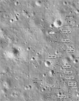
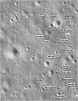
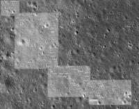
Posted by: Phil Stooke Jan 11 2019, 11:17 PM
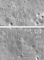
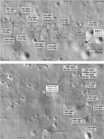
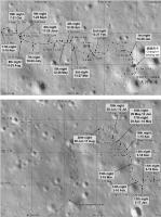
With new data and images, a new map. The base is now a mosaic of descent frames (with room for more details to be added), and the scale is shown by the 10 m grid. The path is redrawn to fit the new base. I hope this will be good for a couple of lunar days. please let me know if you see any mistakes or if you find anything I should add to the map.
Phil
|
Posted by: threadworm Jan 12 2019, 01:26 PM
Looking at the selfies posted from the rabbit earlier it looks to have circled round to the rear of the lander having first gone west. Look at the rover tracks heading south from the lander.
|
Posted by: Phil Stooke Jan 31 2019, 07:34 PM
According to tweets from China including this one:
https://twitter.com/ShanghaiEye/status/1090927343311286273
and post 1679 on this forum:
http://www.9ifly.cn/forum.php?mod=viewthread&tid=5819&extra=page%3D1&page=84
Yutu 2 appears to have moved 8 m northwest from the last position I knew about. Accordingly I have updated my route map:

|
Keep in mind the way information is released. You can expect to see a lot of iterations of this map as bits of news appear from various sources. It is possible the latest drive was the last before the lunar night began. EDIT - I have concluded that the drive did in fact take place before the lunar night, and changed the map accordingly.
Phil
Posted by: Explorer1 Jan 31 2019, 07:38 PM
LRO should be taking its image of the site today; should make your job at least temporarily a bit easier once that's down-linked and released
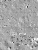
Posted by: Phil Stooke Feb 4 2019, 08:45 AM
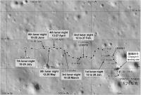
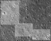
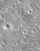
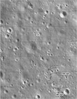
CCTV screen shots posted on the 9ifly forum show more drives this lunar day which are mapped here. My date labels may need a bit of editing but this is the best i can do right now.
Phil
|
EDIT - added a link to the forum page with the screenshots. Look at the next page as well for a picture of the lander taken about noon last lunar day.
http://www.9ifly.cn/forum.php?mod=viewthread&tid=5819&extra=page%3D1&page=87
Posted by: Station Feb 4 2019, 01:47 PM
Hi Phil,
I tried to locate the screenshots on chinese forum you mentioned, but ...unfortunately I've got nothing.. Could you please post here few screeens you're talking about? Thanks in advance.
Posted by: vikingmars Feb 4 2019, 02:54 PM

Phil
Thank you very much Phil

By the way, do you know how far Yutu 2 is able to explore within reach of radio contact with its lander ?
Or can it rove far away and transmit its data via the relay satellite ?
Thanks in advance for your answers and with warmest regards, VM
Posted by: Phil Stooke Feb 4 2019, 07:27 PM
Yutu can communicate with the relay on its own. It is designed to operate far away from the lander.
Phil
Posted by: vikingmars Feb 5 2019, 06:49 AM
Thanks Phil

Posted by: Phil Stooke Feb 5 2019, 07:50 AM
The last date on my map above should be 1 Feb., not 2 Feb. - now I have seen a better source image I can see the date. We are now in the noon siesta period.
Phil
Posted by: monty python Feb 5 2019, 09:18 AM
Just looking at the path it's taking, I would say the rover drivers prefer level ground.
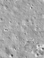
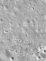
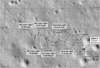
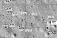
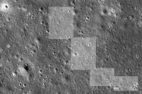
Posted by: Phil Stooke Feb 18 2019, 12:12 AM
No new information really, except the total distance driven (120 m) and an azimuth derived from the latest image of the lander against the hills of the SE horizon... but here is a new map showing the approximate location of Yutu-2 during the second night. The background image needs some minor adjustment of scale and position which I will deal with as soon as I can.
Phil
|
Posted by: kenny Feb 18 2019, 07:34 AM
So it has now exceeded the drive distance of Yutu-1?
Posted by: SpaceListener Feb 18 2019, 03:33 PM
A recent picture from LRO on Chang'e-4' landing site
http://www.spxdaily.com/images-hg/far-side-of-moon-iau-chang-e-4-lroc-m1303619844lr-hg.jpg
Further details: http://www.moondaily.com/reports/IAU_names_landing_site_of_Chinese_Change_4_probe_on_Far_Side_of_Moon_999.html
Posted by: Phil Stooke Feb 18 2019, 06:33 PM
Yes, Kenny, it has exceeded the first Yutu's distance. And Sojourner's.
Phil
Posted by: John Moore Feb 18 2019, 09:50 PM
Phil...to see rover tracks: presuming LRO will lower its in-orbit altitude downwards?
John
Posted by: Phil Stooke Feb 19 2019, 02:14 AM
No, don't look for any change in the orbit, they are conserving fuel. But images with higher sun angles will show the tracks very well. They show up in Chang'e 3 images from LRO at a higher altitude. What I really need is a Chinese map of the path, better than the oblique rendering we have seen up to now.
Phil
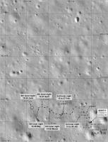
Posted by: Phil Stooke Feb 28 2019, 12:43 AM
Thanks, John.
Here is an update based on a map seen on the 9ifly forum. That map has some issues but for now it is the best source I have. I'm hoping to see a map at LPSC in a few weeks.
Note that the base image has been adjusted a bit since the last map.
Phil
|
Posted by: elakdawalla Mar 4 2019, 04:11 PM
Just a reminder that the route map threads are strictly for posting route maps; please converse about mission operations in the appropriate thread.
Posted by: Phil Stooke Mar 4 2019, 08:06 PM
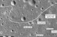
A very approximate location for our current position. It is based on the distance travelled, 7 m, an assumption that some of that was taken up with maneuvering to get the rock in the instrument field of view, and an interpretation of the wide angle image.
Phil
|
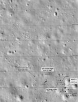
Posted by: Phil Stooke Mar 13 2019, 03:47 AM
Another iteration of the map. I wanted to get the first 2 lunar days on the close-up map.
Phil
|
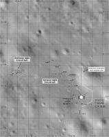
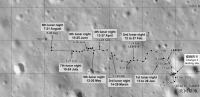
Posted by: Phil Stooke Mar 22 2019, 03:34 AM
A map update using the new LRO image to get an exact position for the second lunar night (it only needed a very small correction). I also estimate where the third lunar night location is.
Phil
|
Posted by: Phil Stooke Mar 25 2019, 05:58 PM
Andrew Jones tweeted a map here:
https://twitter.com/AJ_FI/status/1110035767697567746
(plus a nice image of tracks)
which allows me to update our map. Note that the Chinese map does not distinguish between daily end-of-drive locations and mid-drive waypoints, which I try to do in my map. In the later parts of the route there are too many stops for days, so some are waypoints. When I know which are which I can add date labels to stops.
Phil
|
Posted by: Phil Stooke Apr 27 2019, 12:14 PM
No real news but I decided to show an estimate for the new location at the end of day 4. We are told the day 4 drive was about 30 m, probably not in a straight line. I have no evidence for the location, this just lets me record the dates and I can update it when I actually know something. A new LRO image would be nice!
Phil
|
Posted by: Phil Stooke May 17 2019, 05:09 PM
This is a slightly tentative route map up to day 5, with the day 4 drive estimated from day 4 tracks visible in the new images. When I realized that the early day 3 rocks were visible in the track images I understood the track images better. The positions are still only approximate for the 4th day.
Phil
|
Posted by: Phil Stooke Jun 10 2019, 07:00 PM
China isn't exactly making my life easy at the moment, and my maps will not improve much until a Chinese version appears. Most likely that will be in a journal article in the coming months.
However, here is my current version of the map. The 6th night location is an estimate with very little (OK, nothing) to support it. I have plotted the 5th night location a little more securely from the latest images of tracks and a crater to the south. Anyone who spots new information - let me know!
Phil
|
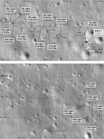
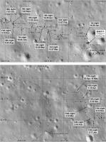
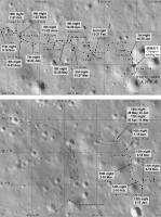
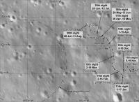
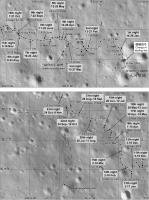
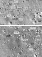
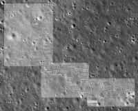
Posted by: Phil Stooke Jun 26 2019, 07:19 PM
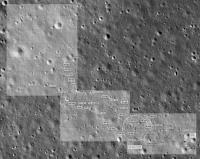
Pictures from lunar day 6, released at the start of lunar day 7, let me revise the route map. I don't really know that those images cover all the day 6 tracks or that I have joined them correctly, but this is what i have at the moment.
3 maps this time. The first is the updated version of the previous map. The other two are more detailed maps adding labels from a recent Chinese map noted in the other thread. I have changed symbols and added a legend to match previous work on Chang'e 3's route map.
Phil
|
|
|
Posted by: Phil Stooke Jul 9 2019, 08:30 PM
This is a preliminary update based on the reprojected image shown in the other thread. I think that image is from the mid-day siesta, based on illumination, and there is no indication how far Yutu 2 has moved since then. My scaling of the new drive is only approximate. So basically it's all guesswork so far. But I am suggesting a drive on the order of 40 m on the 7th day.
Phil
|
|
Posted by: Phil Stooke Aug 7 2019, 05:30 PM
Andrew Jones tweeted a total distance of 271 m after day 8 which lets me estimate a new position. Since the last map I have pulled my estimated position for the end of day 7 back a bit. This map extends the base to the west to show a sharp-rimmed crater ahead. Will it be a future target? I am trying to decide if this crater is shown as a bright band across one of the newly-released images (see discussion in the main thread).
Phil
|
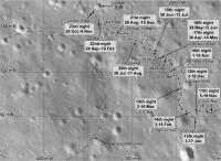
Posted by: Phil Stooke Sep 18 2019, 08:59 PM
Took a while to get this together from the latest data. As always, changes may be needed later!
Phil
|
Posted by: Phil Stooke Oct 2 2019, 10:06 PM
A new paper in Earth and Planetary Science Letters ( Gou et al., 2019. Lunar deep materials observed by Chang'e-4 rover. Earth and Planetary Science Letters, v. 528, 115829. https://doi.org/10.1016/j.epsl.2019.115829 ) provides more details of VNIS operations. I have used it to update the more detailed version of my map.
Phil
|
|
Posted by: Phil Stooke Nov 5 2019, 09:29 PM
This is my estimate of the location after the 11th day of operation. The point is chosen to give a distance from the lander of 218 m, a path in day 11 which avoids craters, and to reflect my hope that the prominent crater SW of the current position will be investigated. Needless to say, I may have to revise this when I get new images of the tracks.
My lunar night dates are a bit unreliable, but I have not found time to check the actual sunset-sunrise dates for each month. I will try to sort that out soon. I think my dates are mixing up UTC dates and dates in China, and are further messed up by my efforts to adjust them.
Also this is a composite of two maps joined together, and the join is not perfect. Mars has been interfering with the Moon in my life recently.
Phil
|
Posted by: Phil Stooke Dec 13 2019, 02:11 AM
A new map update using the newest Day 12 images.
Phil
|
Posted by: Phil Stooke Jan 4 2020, 03:43 AM
OK, new data! From maps and a video of the traverse tweeted by Andrew Jones I have updated the route map to the end of lunar day 13.
This base image (an LRO orthophoto) has been adjusted to match the Chinese maps. My grid is labelled with zero at the lander, which I prefer to their approach. The last few days are based on images of tracks including frames from the video. The tracks in the video show the actual traverse pattern but the landscape is schematic, not the real pattern of craters.
Phil
|
EDIT: Map replaced on 4 Jan 2020 - correcting two errors.
Posted by: Phil Stooke Jan 16 2020, 08:07 PM
This is my current route map, updated using the new panoramas from the PDS release and other recent images. Thanks to Doug for all his work on panoramas.
|
Yutu 2 will soon wake up for lunar day 14. The Chinese PDS node just released the lunar penetrating radar data for the first two lunar days.
Phil
Posted by: Phil Stooke Feb 7 2020, 08:52 PM
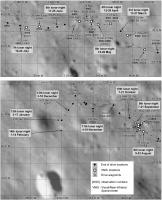
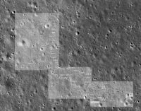
I am incorporating those observation numbers (or whatever we should call them) into the map, and correcting dates as I get more information. This is the enlarged version of the map, and I will repost the first panel of this map (the landing site) later when i have done more to it. Oh yes - and I am adding parts of reprojected panoramas where I have them - lots more to add.
I don't have any information on the 14th night location so it is only roughly indicated.
Phil
|
Posted by: Phil Stooke Feb 8 2020, 06:21 AM
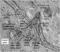
Here's a special map of the area around the impact glass crater. I'm not certain of every detail but this fits everything I know so far.
Phil
|
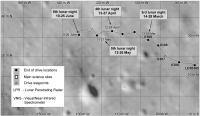
Posted by: Phil Stooke Feb 15 2020, 09:42 PM
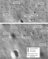
Here is an updated version of the map. Still no information on the day 14 activities but I have corrected dates and updated the 4th night location.
Phil
|
EDIT:
Stop the presses!!! Just learned more via a tweet from Andrew Jones with a link to a drive diary and new images. Now I can update day 14 properly.
Phil
|
Posted by: Phil Stooke Mar 5 2020, 06:04 PM
Here's a map update to day 15, which just ended. The details of the last few days have been adjusted to match new maps which Andrew Jones tweeted recently (I will put a link to the source in our main thread). I am having a bit of trouble reconciling that map with published drive distances, especially for day 15 which should show 33 m driving. The grid on this map is 50 m by 50 m. It is possible that the newly released map doesn't go right to the end of day 15. The large degraded crater now shown on the map is described in the Chinese source as an obstacle they have to avoid so they are going to pass it on the northeast side as they begin a long trek to the northwest. They have turned away from the prominent crater to the south of the 13th night position which was an earlier target.
Phil
|
Posted by: Phil Stooke Apr 8 2020, 09:37 PM
A very tentative update to the 16th lunar night, which we are in as I post this. It's based on nothing but drive distances, and since I am dubious about my 15th night location (see above) I show a large uncertainty in the location for the 16th night. I hope to know more soon.
Phil
|
Posted by: Phil Stooke Apr 8 2020, 11:42 PM
This is an updated version of the map shown a few posts ago, the impact glass (AKA 'gel') crater. The base image is more accurately projected based on a map in a new paper by Ding et al. in Geophysical Research Letters. Some changes to site designations as well. The paper suggests that this and other small blocky craters seen nearby are secondaries from Zhinyu crater, 40 km to the west.
Phil
|
Posted by: Phil Stooke Apr 12 2020, 07:09 PM
Another close-up map: this is the rock analyzed by VNIS on day 3:
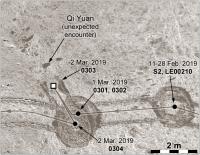
|
And look! One rock has a name, Qi Yuan, translated as 'unexpected encounter'. The first name I've seen for any feature along the traverse. This comes from here:
https://els2020.arc.nasa.gov/abstracts (PDF file)
- the abstracts for the upcoming European Lunar Symposium, which will be held virtually next month. On Page 52 of the PDF file is an abstract about this rock with the name included. A full paper is due out soon but not yet available.
Phil
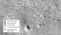
Posted by: Phil Stooke Apr 15 2020, 05:35 PM
I have updated the route map based on a map in the latest drive diary:
https://mp.weixin.qq.com/s/n7ic77uIA-QtniYSRD6gcg
(thanks to Andrew Jones for pointing it out to me).
The 15th night location has been moved to a point where the daily distance figures make sense.
Phil
|
Posted by: Phil Stooke May 1 2020, 08:12 PM
This map updates us to the end of lunar day 17. Using images from the latest drive diary tweeted by Andrew Jones I have been able to map the path reasonably well for day 17 (recent days have been based mostly on Chinese mapping). The exact locations of the last 2 points are a bit uncertain still.
Phil
|
Posted by: Paolo May 9 2020, 09:11 AM
I don't know how useful it can be, but this paper (in Chinese) includes some details of the route of the first and second lunar day:
http://engine.scichina.com/publisher/scp/journal/SST/doi/10.1360/SST-2019-0350?slug=fulltext
Posted by: Phil Stooke May 31 2020, 09:17 PM
Thanks, Paolo. This is interesting but doesn't add anything to the early route map which is well documented.
No move during day 18, but I believe we will be back in action for day 19. My map is not changed except for text updates, including the rock name mentioned earlier.
I have been enjoying seeing my map turn up on various Chinese forums and outlets, sometimes with little additions. It's fun to see it diffuse out into the world like that.
Phil
|
Posted by: Phil Stooke Jun 28 2020, 03:58 PM
A tentative update to the end of the 19th day. No information about the actual path, I am just guessing from descriptions of what was done. An image showing tracks doesn't include anything from day 19, it was taken close to the previous night stop. Possibly it was taken at the mid-day stopping place as it has roughly mid-day lighting, but only more distant tracks are visible.
Phil
|
Posted by: Phil Stooke Jul 30 2020, 02:38 AM
Another tentative update for the end of day 20. I hope to know more after the drive diary is published some time during the 20th lunar night.
Phil
|
Posted by: Phil Stooke Aug 2 2020, 07:26 AM
A new drive diary was published here:
https://www.bilibili.com/read/cv6997981
It gives me details for a corrected map:
|
Only the last drive is guessed here. I think the map published in that article is for the end of the mid-day siesta (it's dated July 23), not the end of the day.
Phil
Posted by: Antdoghalo Aug 13 2020, 03:08 AM
Hey Phil, could you please upload the map as 2 separate images every now and then so I can overlay them into Google Earth?
Posted by: Phil Stooke Aug 13 2020, 05:11 PM
OK! Send me a reminder when you need it if I forget. These are larger files as well.
Phil
|
|
Posted by: Antdoghalo Aug 13 2020, 05:27 PM
Many Thanks!
Posted by: Phil Stooke Aug 13 2020, 08:35 PM
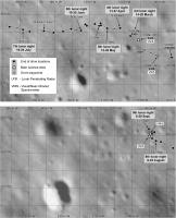
This is a bit of an experiment. I am plotting reprojected panoramas onto the base image, using only panoramas with morning to noon lighting (with one exception which I won't go into here). I'm working on the next section now. This version of the map has more information about where VNIS was used, the site numbers etc.
Phil
|
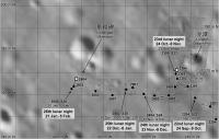
Posted by: Phil Stooke Aug 28 2020, 09:16 PM
Update to the end of day 21. The last 2 sections of the drive are pure guesswork and very tentative.
|
Phil
Posted by: Phil Stooke Oct 4 2020, 07:53 PM
Day 22 update. The last points on the previous map are corrected and day 22 should be good.
Phil
|
Posted by: Phil Stooke Oct 24 2020, 03:27 AM
This is a quick update for lunar day 23. The exact path will be updated later but the path and the end point should be roughly correct.
Phil
|
Posted by: Phil Stooke Nov 4 2020, 10:01 PM
This is still an approximation for the 23rd day drive, but it's based on much more information. It will probably be revised quite a bit when a Chinese map appears.
Phil
|
Posted by: Phil Stooke Nov 30 2020, 09:24 PM
No drive diary or other information yet so I still have nothing but a distance with which to update my map. This is just an estimate, but day 23 has been updated.
Phil
|
Posted by: Phil Stooke Dec 22 2020, 07:01 PM
Here is a map up to the end of day 25 (with the last drive just speculation on my part). I posted it in the main thread by mistake but now have moved it.
Phil

|
Posted by: Phil Stooke Jan 3 2021, 08:07 AM
A new drive diary tweeted about by Andrew Jones gives details allowing a proper update to the 25th night.
Phil

|
Posted by: Phil Stooke Feb 3 2021, 07:52 AM
Two maps for the end of the 26th day. The details of day 26 are estimated from the latest drive diary and are very much subject to revision.
Phil

|
|
Posted by: Phil Stooke Feb 20 2021, 08:16 AM
This is a corrected version of the map for the end of day 26. No news on day 27 yet except a distance of 24 m driven.
Phil
|
Posted by: kymani76 Mar 8 2021, 04:14 PM
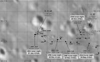
Yutu 2 drive map updated to lunar day 27. The rover just started its 28th lunard day of operations. Total drive distance is approximately 632 meters.
|
Original article used for the update:
https://www.163.com/dy/article/G4JNJOQG0531TTYW.html
Posted by: kymani76 Mar 8 2021, 04:47 PM
|
If I understand above mentioned article correctly, they plan to make 1.2 km traverse to the basalt area to the northwest on day 28.
If true it will triple the total distance driven so far.
Posted by: Phil Stooke Mar 8 2021, 09:16 PM
They are driving in that direction during the 28th day, but they will not reach the basalt for a long time. They will be hoping for a stray ejecta block from the basalt to get an analysis of that material during the long drive.
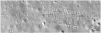
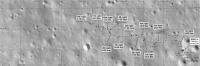
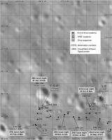
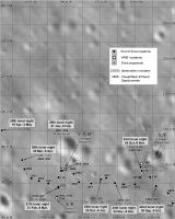
Here are my maps for lunar day 27 (I have to try very hard not to write 'sol 27'). There are slight discrepancies between different Chinese traverse maps with the exact positions of sites and drives, so this is an attempt to reconcile the sources. It's not guaranteed to be exactly right.
I am using names like Milestone and Stalagmite as if they are feature names. They might not be intended as real names but they are getting into social media and press accounts so my maps at least show where they are.
Phil
|

|
Posted by: John Moore Mar 8 2021, 11:19 PM
The nomenclature names confused me, too, Phil.
As none of these has been officially approved by the IAU (at this stage), their significance is purely for purposes of identification, I suspect.
I wonder did the Apollo team of missions do such too?
John
Posted by: Phil Stooke Mar 8 2021, 11:41 PM
All our Mars missions give informal names to features and targets around them, and so did the Apollo astronauts and China with the first Yutu. Most of the Apollo names were eventually made official. These will not be, I expect, but I think it is good to record them especially if they are being spread around in social media and publications.
Phil
Posted by: John Moore Mar 9 2021, 12:00 AM
Well, at least, the IAU gave official refence to https://planetarynames.wr.usgs.gov/Feature/15970 (on Mars), and the two craters of https://planetarynames.wr.usgs.gov/Feature/15938 and https://planetarynames.wr.usgs.gov/Feature/15959 on the Moon...at the start of 2021.
As to recording them around the social media, unofficial, as such ("I think it is good to record them especially if they are being spread around in social media and publications") then that will just lead to further confusion in the general, reporting media as such. But I know what/where you mean/are going.
John
Posted by: Phil Stooke Mar 9 2021, 12:51 AM
My feeling is that informal names are just as significant as formal names. They are all part of the history of exploration. Formal names are just a subset of all names.
Phil
Posted by: John Moore Mar 9 2021, 04:20 AM
Yeah, see your point, Phil...you're right.
John
Posted by: Phil Stooke Apr 8 2021, 03:20 AM
This map takes us up to the end of lunar day 28. We are just getting into day 29 so it looks like I will be needing a new map.
Phil
|
Posted by: Phil Stooke Apr 27 2021, 06:07 AM
This is a very rough map for lunar day 29. Up to the 28th night it is based on Chinese maps. For day 29 I only have a distance. If we get a drive diary I may be able to add more detail, but last month there was no drive diary (that I am aware of) for the first time in 2 years.
Phil
|
Posted by: Phil Stooke May 9 2021, 02:14 AM
A drive diary did show up here:
https://www.163.com/dy/article/G9E3124Q0531TTYW.html
(they can appear in various places. Thanks to Andrew Jones for pointing out another version of this)
And it allows me to update the map. Still a bit uncertain in the last 2 drives.
Phil
|
Posted by: Huguet May 12 2021, 01:01 PM
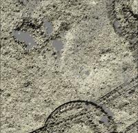
The PCAM stereo clusters of images from Yutu-2 allow to generate 3d models of the path on almost a mm resolution. Its interesting to understand the craters patterns on the path.
The smallest craters are within 20 cm of diameters and they exist all over the soil, like a pattern over it.
Its interesting to see how the craters overlap beetween each other.
They didn't choose a path without craters, but which path has the smallest craters.
Data working with from moon.bao.ac.cn, PCAM images from jan19 to mar20. I haven't seen any PCAM batch of images after this date, if anyone has that i would apreciate the link.
|
|
|
Posted by: Phil Stooke May 12 2021, 11:39 PM
The first big data release covered that period you mentioned. Since the there have been several smaller releases. They are listed here:
https://moon.bao.ac.cn/

|
(right side in the data release window)
You can see there also data sets from CE5 and the international experiments carried on CE4.
Phil
Posted by: Huguet May 13 2021, 10:53 AM
The most recents there are from Apr 2020. On Scientific Data, CE4, PCAM, 2B.
So i believe that they are puting the data online 1 year after geting it...

|
Posted by: Phil Stooke Jul 8 2021, 06:37 AM
Very little news about Yutu 2 except a statement about driving 30 m during the 31st day. This is just a rough idea of where the rover may be. We are into day 32 now (probably in the noon-time siesta period).
Phil
|
Posted by: Phil Stooke Sep 5 2021, 03:21 AM
Not much news lately except distances driven. Just for the sake of having something to post, here is a very crude estimate of locations up to the end of lunar day 33.
Phil
|
Posted by: Phil Stooke Sep 29 2021, 06:52 PM
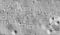
Finally - an update on Chang'e 4 and Yutu 2. Thanks to Andrew Jones for finding it. This map goes up to the 34th night - which is just ending as I post this. The 40 m drive in lunar day 34 was the longest since the 3rd lunar day.
Phil
|
Posted by: Phil Stooke Sep 30 2021, 12:44 AM
Here is a full route map for Yutu 2 combining the separate maps I have been making.
Phil
|
Posted by: Phil Stooke Oct 26 2021, 08:04 PM
An update at this site:
https://mp.weixin.qq.com/s/_zVG8NHfwZWzXWhdGWHJlg
gives a new map and some images. Here is an updated map:
|
The turtle name refers to a group of craters surrounding a shallow degraded crater which is the turtle shell (looks more like a turtle in images with more contrast and evening lighting). The valley mentioned here refers to a historic military event, a detour which took an army off the main route as part of a major campaign. The path here was a detour around a crater and to the northwest after a few days of moving mainly west.
Phil
Posted by: Phil Stooke Nov 4 2021, 01:59 AM
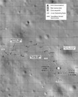
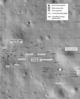
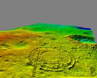
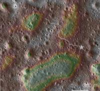
You might enjoy this map showing the landing region with topography and the route so far.
The base image is an ortho image from LRO. The topography is from Figure 1 in this paper:
Xiao, Z., Ding, C., Xie, M., Cai, Y., Cui, J., Zhang, K. and Wang, J., 2021. Ejecta From the Orientale Basin at the Chang'E‐4 Landing Site. Geophysical Research Letters, 48(3), p.e2020GL090935.
Blue and green areas are low, red and neutral shades are high. The total range of topography is about 20 m.
The top left corner of the map is the basaltic region which is a long-term goal for Yutu 2. It would take another 4 years to get there at the current rate.
Phil
|
Posted by: Phil Stooke Dec 3 2021, 08:19 AM
This is an update for lunar day 36. The drive during day 36 is an interpretation from the latest drive diary, partly based on images in that diary. I may be correcting this soon!
The large rock on the northern horizon (described and illustrated in the drive diary) is on the rim of the prominent crater about 75 m north of the current position. That crater and the blocks on its rim will be reached after 2 or 3 lunar days driving.
Phil

|
Posted by: Phil Stooke Dec 3 2021, 08:29 AM
And the full map including the last few months.
Phil
|
Posted by: marsbug Dec 5 2021, 10:29 PM
Thanks for keeping the updates going Phil, it's much appreciated!
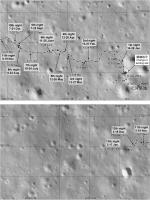
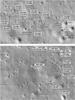
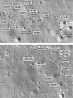
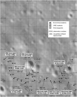
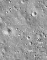
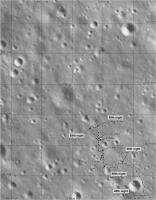
Posted by: Phil Stooke Jan 4 2022, 04:25 AM
A Chinese map up to the 37th day has been released, though not at a very legible scale yet. I have used it to update my map, but this might be improved when a better original shows up.
I am making the assumption that the 'Mystery House' is on the far rim of the crater, not the southern rim.
Phil
|
|
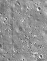
Posted by: kymani76 Jan 14 2022, 11:51 PM
|
My version in addition to Phil's.
Posted by: Phil Stooke Jan 16 2022, 08:38 AM
A very small map shown on sohu.com ( https://www.sohu.com/a/516861625_121218495 ) suggests the path during day 38. It is roughly sketched here, and I will update this when we get better data.
EDIT: Better map in a video on this site: http://www.hljtv.com/news/folder9/2022-01-16/848897.shtml
I removed the earlier map and replaced it with a better one.
Phil
|
Posted by: Phil Stooke Feb 4 2022, 03:38 AM
We are well into the 39th lunar day today so here is an updated full map.
Phil
|
Posted by: Phil Stooke Feb 27 2022, 12:06 AM
Using images from the drive diary I have estimated the route for the 39th day. This could be wrong! But it's the best I can do at this stage.
Phil
|
Posted by: Phil Stooke Feb 27 2022, 12:53 AM
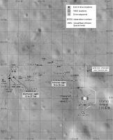
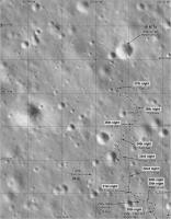
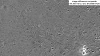
Good news on the map front. The LROC team have updated their featured sites page to include Chang'e 4 and Yutu 2. You can explore their images of the site here"
https://www.lroc.asu.edu/featured_sites/view_site/64
By taking the first (pre-landing) image and one near the end of the period covered with almost identical lighting, it is possible to make a difference image which shows the tracks. The later image was taken during day 35.
Phil
|
Posted by: Phil Stooke Apr 15 2022, 02:54 AM
The latest news discussed in the other thread leads to this updated map. The source is small and unclear so this might need an edit but it is a reasonable estimate at this time. My 40th night location should possibly be at the next stop.
Phil
|
Posted by: Phil Stooke Apr 15 2022, 03:00 AM
And the full map to go with it.
Phil

|
Posted by: Phil Stooke Apr 30 2022, 07:03 AM
Here is a corrected map for the end of lunar day 41. The last day of driving comes largely from a map in the latest drive diary and should be reasonably accurate (the Chinese map - good. My speculation about the last bit - probably OK). I am still not certain about the location of the day 40 stop.
The previous map was based on another chinese map, published quite small and not very clear, but it seems to me that it was not showing the end of day 41 location, it only mapped up to lunar noon on day 41. Speaking of which, as i post this it is noon in lunar day 42.
Phil
|
Posted by: Phil Stooke Jun 17 2022, 07:46 PM
This map for the end of lunar day 42 is updated using he latest drive diary, linked to in the other thread.
Phil
|
Posted by: Phil Stooke Jun 17 2022, 07:58 PM
This context map shows the traverse as of day 42 and the broader context. The rover is nearly half way to the basalt region it hopes to reach, but its goals could be met quite well by finding ejecta blocks thrown out of craters in that area.
Phil
|
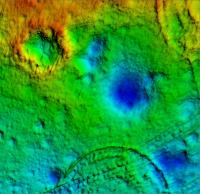
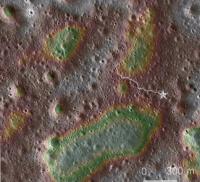
Posted by: Phil Stooke Jun 18 2022, 03:11 AM
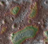
Another context map. A description of how it was made can be found earlier on this thread, but this is updated to lunar day 42.
Green areas are low, red and white areas are high.
Phil
|
Posted by: Phil Stooke Jul 25 2022, 03:25 AM
Here is the full map up to day 44. It leaves me uncertain about day 43 but maybe we will get the details later.
Phil

|
Posted by: Phil Stooke Jan 3 2023, 10:06 PM
The first part of a map update to the end of lunar day 50. I have to work really hard not to say 'sol 50'.
The major goal at this stage is to reach the bright-rimmed crater at top left, which is on the edge of the basalt region. Anywhere between the current location and that crater a basalt ejecta block might be found, so suitable rocks are inspected carefully as they are encountered. It looks like it would take 3 more years to reach the crater. Either Queqiao must last that long or a replacement will be needed, and one is planned for (approximately) 2024 to support Chang'e 6 and this mission.
As I understand it now, the sample return mission Chang'e 6 is aiming for the lava flows and crater ejecta inside Leibnitz crater, slightly north of Von Karman.
Phil
|
Posted by: Phil Stooke Jan 4 2023, 04:13 AM
Here are two sections of my Yutu 2 route map at the standard scale I have been using since landing. Later I will make the overview showing the whole path. Some of the recent night locations are only guessed for now until I have more information.
Phil
|
|
Posted by: Phil Stooke Jan 4 2023, 05:01 AM
And my update of the full map... which needs an extension now.
Phil
|
Posted by: Thorsten Denk Jan 6 2023, 11:10 AM
You could say "month"...

Thorsten
Posted by: Phil Stooke Jul 12 2023, 06:11 AM
Good point, Thorsten!
A new map at last! This small extension of what I had before is based on the two LRO images in the main thread. I will update this after every LRO release as time permits.
Phil
|
Posted by: Phil Stooke Sep 5 2023, 07:19 PM
Andrew Jones has tweeted ( I can't say 'Xed') new Yutu 2 images from Seger Yu:
https://twitter.com/AJ_FI/status/1698603095289221546
(follow the link for more images)
They allow a map update because the craters can be identified in LRO images and the tracks interpolated. Slow progress - suggesting either focussed science work in this area, or perhaps reduced communication opportunities via the aging Queqiao relay satellite.
So here is a Yutu 2 map update for June 2023:
|
Phil
Posted by: marsbug Sep 6 2023, 01:35 AM
As ever: Thanks for doing this Phil!
Posted by: Phil Stooke Sep 12 2023, 06:54 AM
You're welcome!
Here is the full traverse with my new additions. The bright ray crater at top left is a major goal of the mission, as is the basalt region just beyond it.
Phil
|
Posted by: Phil Stooke Sep 19 2023, 06:50 AM
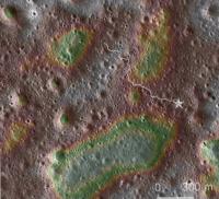
The same path shown on a topo map - green is low, red is high.
Phil
|
Posted by: Phil Stooke Sep 27 2023, 08:09 PM
https://m.weibo.cn/p/index?extparam=%E6%9C%88%E7%90%83&containerid=10080840c4a978b6d1fd790a0d21c1f24d1391
I'm not alone -
9-25 00:17 Super talk from the moon
Yutu 2's route during the first 56 months. It can be seen that Yutu 2 is about to enter a low-lying area.
It is produced based on the data header file of the Yutu-2 visible and near-infrared spectrometer and extracts the coordinate information.
Data source: Planetary Exploration and Data Release System
base map source: LRO
For more information, please see the public account: New Knowledge on the Solar System
Moon #月# #嫦娥4 successfully landed on the far side of the moon# # Popular science#
This weibo post included the following map:
|
It goes 1 month after my recent update. It doesn't show the actual route, just the points where the VNIS was used for composition observations. A large number recently, so possibly there is something different about this area - more basalt fragments?
If this is overlaid on my full map it agrees with the map early in the mission but drifts off (moving a bit further north and west, about 10 m total) in the later part. But the full map is based on Chinese maps when we were getting them, and images of the rover plus tracks in LRO images. These VNIS positions are a bit off. I don't know why, possibly an inexact registration with the base or a slightly different map projection.
In case you were wondering, we are in the 59th night right now.
Phil
Posted by: Phil Stooke Sep 30 2023, 02:33 AM
Andrew Jones tweeted a map up to the present date (end of day 59):
https://twitter.com/AJ_FI/status/1707666256625598753
So here is my updated map at last.
Phil
|
Posted by: Phil Stooke Oct 16 2023, 06:10 PM
My full map up to the end of day 59.
Phil

|
Posted by: Phil Stooke Mar 4 2024, 09:28 PM
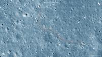
My estimate of the new position based on that new image. I still think only 1 or 2 drives per lunar day, but assuming it's the fault of Queqiao, not Yutu 2, we may see a change later this spring. Queqiao 2 is duu to launch on March 18th according to a recent report.
Phil
|
Posted by: Phil Stooke Jun 3 2024, 07:39 PM
Seger Yu has tweeted details about recent activities of Yutu 2, including images which can be found here"
https://x.com/SegerYu/status/1797559594610528614
I have used them to make a small update to the Yutu 2 map. Motion is still restricted but we may see that change soon (these details predate the new relay satellite). On day 65 Yutu 2 drove another 8 m, not shown here.
Phil

|
Powered by Invision Power Board (http://www.invisionboard.com)
© Invision Power Services (http://www.invisionpower.com)