Printable Version of Topic
Click here to view this topic in its original format
Unmanned Spaceflight.com _ Chang'e program _ Chang'e-4 farside landing mission
Posted by: A.Nemo Jul 15 2015, 01:35 PM
Preliminary Suggestions for International Cooperation on Chang'E-4 Lunar Probe
Xu Y. (China)
http://www.unoosa.org/pdf/pres/copuos2015/copuos2015tech08E.pdf
An Introduction of ChangE-4 Probe:
Probe(Lander,Rover)+ Relay Statellite
Soft-landing on lunar farside
Landing and roving exploration
Will be launched between 2018 and 2019
the probe:
ChangE-4 probe,lander and rover have the same technical status with the ChangE -3; but exploration will be redesigned; the payload will be reconfigered; The name of the probe might be changed.
ChangE-4 probe is a backup spacecraft of ChangE -3 probe. By now, all platform products of the probe have been manufactured, waiting for further AIT.
The probe will be launched by a long March 3B rocket from the Xichang Statellite Launch Center(XSLC) which is the same way with the Chang'E-3 between 2018 and 2019
The relay statellite:
will be first launched into a lunar transfer orbit about the end of 2018 in the whole mission, then starts its earth-to-moon jurnery alone, and will enter and run in a Halo orbit around the Earth-Moon L2 point; the design life is 3 years.
would provide relay service for the probe and the Earth, and carry out exploration.
Engineering objectives are as follow.
To realize the first soft landing on the lunar farside and perform exploration in human history.
To demonstrate technologies of lunar data relay, landing and roving on complicated terrains of the lunar farside, and lunar night power generation;
To perform further detailed survey on lunar environment in order to lay a foundation for subsequent lunar exploration mission.
Tentative Scientific objectives are as follow.
To study lunar surface dust features and its formation mechanism;
To perform in-situ measurement of lunar surface residual magnetism
and study its interaction with solar wind;
To study lunar surface temperature and particle radiation environment;
To perform lunar surface topology and material composition analysis,
shallow-layer structure survey and study;
To explore and study lunar interior structure of spheres;
To perform lunar based VLF astronomical observation and study
Posted by: A.Nemo Jul 15 2015, 01:43 PM
there is a puzzle news:
http://www.cnsa.gov.cn/n1081/n7529/n308608/725881.html
中欧深空探测研讨会在北京召开
发布日期:2015年07月14日 字体:【大】【中】【小】
2015年7月9日至10日,中国国家航天局与欧洲空间局在京召开中欧月球探测研讨会,会议围绕嫦娥四号目标任务和有效载荷搭载进行了讨论。
会上,欧洲空间局相关专家提出利用嫦娥四号搭载月震仪、快闪相机、激光反射器等载荷的建议。经商议,双方初步确定将月震仪和快闪相机等四个有效载荷纳入合作范围。欧洲空间局负责协商欧洲载荷以及其总成与接口,中方通过双边航天局长会晤推动建立载荷研制国技术团队,争取在2018年提交正样。
来自法国巴黎索邦大学、瑞士苏黎世理工、澳门科技大学以及中国国家航天局探月与航天工程中心、中国科学院、北京大学、中国科学技术大学、中国地质大学等单位的专家学者参加了会议。
laser reflector, it means Chang'e 4 will be landed on nearside, What will happened?
Posted by: Juramike Jul 15 2015, 01:49 PM
(Edited!)
Posted by: Phil Stooke Jul 15 2015, 03:52 PM
The current Chinese plan is to land on the far side. The laser reflector is suggested as a high priority payload by an ESA group looking at cooperation. The two don't work together, so we don't know which way it will go. But it's not a contradictory plan, it's an external suggestion to change the plan. Probably won't happen, because the prestige (and science value) of the first far side landing is likely to trump that one payload suggestion.
Incidentally, there's really no reason why that laser reflector shouldn't be mounted on the landing stage of the Chang'E 5 sample return lander, which will be near side. That's a far more likely outcome than flying it on CE4.
Phil
Posted by: Yeh Sep 8 2015, 01:38 PM
Today there's an official confirmation from Xinhua (the state media) that CE4 will be land on the farside: http://news.xinhuanet.com/tech/2015-09/08/c_1116498505.htm (in Chinese).
Posted by: tolis Sep 9 2015, 01:46 PM

In that case, they will need a relay satellite, either in lunar orbit or further afield eg Earth-Moon L2
Posted by: Phil Stooke Sep 9 2015, 01:54 PM
It's at L2. More details here:
http://forum.nasaspaceflight.com/index.php?action=dlattach;topic=33402.0;attach=1064984
Phil
Posted by: bobik Jan 6 2016, 12:55 PM
This refers probably to the micro-reflector array http://www.lnf.infn.it/esperimenti/etrusco/documentation/JAMP_2015013014523399.pdf (Instrument for landing-Roving laser Retroreflectors Investigations). INRRI has been sized to give the right signal for LOLA (Lunar Orbiter Laser Altimeter) on LRO. By the way, one INRRI was mounted on EDM Schiaparelli as long-time scientific asset.
Posted by: Thorsten Denk Jan 14 2016, 01:39 PM
It seems that Cháng'é 4 will go to the lunar farside end of 2018!
Chang'e 4 mission given goahead.
Relay sat in Jun 18, followed by landing on Moon far side in late 2018.
https://twitter.com/SinoDefence/status/687618528933998592
http://www.chinadaily.com.cn/micro-reading/china/2016-01-14/content_14484287.html
Thorsten
Posted by: bobik Apr 14 2016, 06:01 PM
German http://www.uni-kiel.de/pressemeldungen/index.php?pmid=2016-106-mondmission&lang=en experiment is going to the lunar far side.
Posted by: A.Nemo Apr 15 2016, 08:19 AM
China Follow-on Luna Exploration Projects:
2018,Chang'e-4 to farside of Moon
2023,Chang'e-6(?) ,sample&return from farside of Moon
2025,Chang'e-?, south pole landing & large area cruise
2027,Chang'e-?, north pole landing & ISRU Experimental

|
Posted by: bobik May 17 2016, 06:45 AM
A http://els2016.arc.nasa.gov/downloads/ELS_2016_Abstract_Booklet.pdf installed on the relay satellite and the Swedish http://gbtimes.com/china/sweden-joins-chinas-historic-mission-land-far-side-moon instrument for the rover are two other European contributions to the Chang'e-4 expedition.
Posted by: Phil Stooke Jun 3 2016, 02:58 PM
http://www.chinaspaceflight.com/satellite/Deepspace/CE-4/CE-4.html
Chang E IV: June 2018 Long March rocket four C relay communications satellite in late 2018 Long March III B rocket lander and inspection devices.
This item includes an image of the general landing area in the Apollo basin. Long Xiao had suggested to me at LPSC that this would be the (or a) target
http://www.chinaspaceflight.com/usr/uploads/2016/06/03/1464941417135287.jpg
Phil
Posted by: Phil Stooke Jun 20 2016, 11:14 AM
A fascinating new paper is now online - Wang and Liu (2016), A Change-4 mission concept and vision of future Chinese lunar exploration activities, Acta Astronautica (available online 11 JUne 2016). If you have access!
It suggests that Apollo basin is the most likely target but other farside basins are possible. Also looks ahead to future missions, including a suggestion that a robotic station could be built up, possibly as a precursor to human flights. From 3 to 5 landers near the south pole, carrying between them up to a dozen rovers, to build the station, which has obvious echoes of ESA's robotic lunar village.
Phil
Posted by: Explorer1 Oct 2 2016, 05:11 PM
http://spaceflightnow.com/2016/09/29/china-developing-mission-to-return-samples-from-far-side-of-the-moon/
Near side sample return might be launched next year, while the far side relay could be used by other space agencies for their own missions. It would certainly save good money!
Posted by: Phil Stooke Jun 6 2017, 04:15 PM
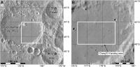
Chang'E 4 landing site:
https://www.chinaspaceflight.com/satellite/Deepspace/CE-4/CE-4.html
Landing area - 45.5 degrees south latitude, 178 degrees east longitude
This is on the flat floor of the large crater Von Karman, with a bit of ejecta from the relatively young crater Finsen. Until now most indications had been for a landing near the Apollo basin at about 42 south, 157 west (203 east).
Phil
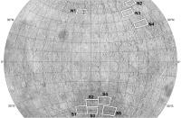
Posted by: Phil Stooke Jun 11 2017, 08:24 PM
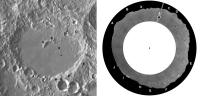
Here's a couple of maps showing the CE4 area.
Phil
|
Posted by: antipode Jun 12 2017, 04:37 AM
Phil
I take it Von Karman's walls are sufficiently lofty to be visible in any surface imagery taken from inside that box?
p
Posted by: Explorer1 Jun 12 2017, 05:35 AM
I wouldn't be so sure; the horizon is really close in the Chang'E 3 surface images. We shouldn't expect huge vistas anymore than we get them on Mars; cool terrain is by definition hazardous!
I would welcome being pleasant surprised to see anything more than a few km away, of course.
Posted by: Phil Stooke Jun 12 2017, 05:16 PM
Short answer - I think some relief will be visible. Von Karman is about 3500 m deep and some distant topography should show up.
I will post something on the Chang'E 3 thread about distant topography. There are distant hills to the north and west at distances of 10 to 15 km, protruding above closer topography. To the east the horizon is about 4 km from the lander.
Phil
EDIT: OK, I posted in the other thread. That was a very flat site, but local high spots can be seen about 10 km away. I would expect that either the central peak of Von Karman or the SE wall of the crater should be visible from the lander, and possibly both will be, as well as small crater rims closer to the landing site. Not high mountains like Taurus-Littrow, but distant features should be visible, appearing as low hills.
Posted by: Phil Stooke Jul 6 2017, 06:01 PM
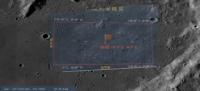
More information on site selection for CE4. This image:
https://www.chinaspaceflight.com/usr/uploads/2017/07/06/1499353834140857.jpg
from this site:
https://www.chinaspaceflight.com/satellite/Deepspace/CE-4/CE-4.html
shows a number of sites at about 45 degrees north or south. I am preparing something on this topic, so I will post a map later. Some sites are in mare-type areas of the SPA basin or the large craters in that area, but the northern sites are all in or between large craters in the highlands (Mare Moscoviense is not one of these areas).
This is from a presentation at the German Aerospace Centre DLR, where China and Germany have just agreed to cooperate on the mission, Germany joining several other countries.
Phil
Posted by: Phil Stooke Jul 7 2017, 12:22 AM
Here is a map of those sites from the slide linked to above.
Phil
|
Posted by: JRehling Jul 7 2017, 01:32 AM
Probably everyone knows this, but on the Moon, the horizon is inherently closer than from a similar vantage point on Earth or Mars. Though the bowl of a crater may make the global curvature locally moot.
Posted by: Phil Stooke Jul 7 2017, 06:00 PM
That's true, of course, but the distance to the ideal horizon is not as important as the height and distance of significant relief features. Von Karman is about 160 km across and up to 4 km deep (wall height varies quite a bit). A good comparison might be with Flamsteed P, the flooded crater which Surveyor 1 landed in. It is 80 km across, but mostly filled with lava and with hills 1500 m high protruding above the plains. Hills 20 km away were visible in the Surveyor 1 panorama. Scaling up, I am confident there will be some relief on the CE4 horizon. Maybe if the landing is in exactly the worst place for viewing relief there would not be much, but from many areas some features will be visible.
Phil
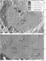
Posted by: Phil Stooke Feb 27 2018, 07:49 PM
The Von Karman site may not be the final word on site selection... it was identified in a paper in 2017, but two papers by Jia et al. in 2018 (one in the Chinese Journal for Deep Space Exploration, the other in Planetary and Space Science, essentially the same content) prefer the site numbered S5 in the map a few posts above. It is south of the Apollo basin and closer to the centre of the SPA basin than any other of those mapped sites. I think all we have right now is competing suggestions, and the final target may still be uncertain.
Phil
Posted by: Phil Stooke Mar 18 2018, 06:09 PM
I'm at the Microsymposium just prior to LPSC. It just concluded, with presentations on the Chang'E program and others. Specifically for this thread, Von Karman seemed to be the likely site again - Apollo was promoted as a good site but probably for a future mission.
Phil
Posted by: Phil Stooke Apr 11 2018, 05:10 PM
Suggest a name for the CE4 relay satellite:
http://www.nssc.cas.cn/tzgg2015/tzgg_tzgg/201803/t20180329_4987980.html
(Google translation)
Concerning the notification of the recruitment of the No. 4 relay star name
Article Source: Release Time:2018-03-29
All relevant units:
The fourth relay satellite will be launched in May 2018. Considering that the No. 4 mission will be the biggest bright spot in China's aerospace field in 2018, to further establish a good image of the lunar exploration project and expand the influence of the project, the Lunar Exploration and Space Engineering Center plans to use the project implementation unit as the main target for solicitation of No. 4 Relay star name.
The No. 4 relay star name collection activity will take place from March 27 to April 15, 2018. The names so collected should reflect the theme of lunar exploration, have innovative and significant technological and cultural characteristics, be positive, and conform to the socialist core values.
Specially invited your organization to participate in this solicitation. Please refer to the attachment for specific requirements.
Attachment: Program for Selection of Relay No. 4 Relay Stars
Moon Exploration and Aerospace Engineering Center
March 27, 2018
Posted by: Phil Stooke Apr 22 2018, 06:20 PM
This link is to the current issue of China's Journal of Deep Space Exploration:
http://jdse.bit.edu.cn/sktcxben/ch/reader/issue_list.aspx
A very interesting set of papers about the CE4 landing site including several suggestions for landing sites and even rover traverse routes. Chinese language with English abstract, but Google document translation will help, and the illustrations carry a lot of information even without translation. Many of these papers will probably appear in English elsewhere at a later date. I can feel a map coming on...
Phil
Posted by: Phil Stooke Apr 23 2018, 11:48 PM
After a suitable gestation period, here is a map of the sites suggested for Chang'E 4 in Von Karman crater. The references are from the previous post except the mention of Snape et al. (2010) which is an LPSC abstract, easy to search for if you need it. THe bottom map includes possible traverses suggested by Mou et al. (2018)
Phil
|
Posted by: Phil Stooke Apr 24 2018, 02:38 AM
http://news.cnstock.com/news,bwkx-201804-4214240.htm
Google translate:
China Securities News reported on April 24 from the National Bureau of Science, Technology, and Technology that during the opening ceremony of the "China Aerospace Day" home event in 2018, Wu Yanhua said that the Chang'e 4 is one of the major tasks for China's space industry this year...
Wu Yanhua announced at the opening ceremony that the No. 4 relay star was named "Bianqiao" and the two small satellites were named "Longjiang No. 1" and "Longjiang No. 2".
Phil
Posted by: Phil Stooke Apr 24 2018, 09:39 PM
Interesting that Google translates that website to give the relay satellite name 'Bianqiao', but all other sources - AND using Google to translate just the characters for that name, give 'Queqiao'. The names mean Magpie Bridge (relay) and Dragon River (the two small satellites), and there are numerous tweets and stories out there today giving the background.
Late in the year we will presumably get a name for the new rover.
Phil
Posted by: Phil Stooke May 20 2018, 10:08 PM
The relay satellite was just launched successfully.
Phil
Posted by: nprev May 20 2018, 10:23 PM
Ah, thanks, Phil! Was wondering; didn't seem to be a live feed available anywhere.
Posted by: Explorer1 May 20 2018, 10:29 PM
Someone at the site pointed their phone at a screen, and streamed it out via a Chinese media platform; looks like the micro-satellites also separated successfully.
Posted by: John Moore May 21 2018, 09:30 AM
https://www.youtube.com/watch?v=TC1bsPDsKgQ of launch, or https://www.youtube.com/watch?v=jgiEr13zkJo (with different aspect view).
John Moore
Posted by: Phil Stooke May 25 2018, 10:40 PM
It seems all is well with our new mission - the relay satellite has passed the Moon and is on its way to its L2 halo orbit. The two little moon orbiters are in lunar orbit. Hoping for an image or two from the Saudi camera on one of them.
Phil
Posted by: Phil Stooke May 27 2018, 09:56 PM
Twitter: Jonathan McDowell @planet4589 2 hours ago
So it looks like Longjiang-2 (DSLWP- is in a 350 x 13800 km x 21 deg lunar orbit. Longjiang-1 seems to have failed on May 21 and presumably remains in distant Earth orbit following its lunar flyby
------------------
I spoke prematurely in my last post - all seems well with the other two spacecraft but Longjiang 1 failed. The small camera is on Longjiang 2. I see some reports that radio enthusiasts will be able to download images from the camera, but I don't know the details yet.
Phil
Posted by: mcmcmc Jun 13 2018, 07:30 AM
"Are we there yet?" 
Posted by: Phil Stooke Jun 14 2018, 04:16 PM
We are!
http://spacenews.com/change-4-relay-satellite-enters-halo-orbit-around-earth-moon-l2-microsatellite-in-lunar-orbit/
Phil
Posted by: mcmcmc Jun 14 2018, 05:49 PM
http://spacenews.com/change-4-relay-satellite-enters-halo-orbit-around-earth-moon-l2-microsatellite-in-lunar-orbit/
Phil
Cool!
Posted by: mcmcmc Jun 14 2018, 06:53 PM
Hayabusa twitter aggregator
http://win98.altervista.org/hayabusa2/TwitterAggregator.html
Posted by: Thorsten Denk Jun 14 2018, 07:00 PM
Nice pic, but it's not new.
It's from Chang'e-5 T1, from october 2014.
This one is new, from the Longjiang-2 micro satellite.
The camera has captured its place of origin, Saudi Arabia. 
Thorsten
Posted by: John Moore Jun 14 2018, 07:13 PM
https://gbtimes.com/authors/658 are always useful for reference/updates.
John Moore
Posted by: mcmcmc Jun 15 2018, 06:51 AM
Better images from Saudi Arabia camera onboard Longjiang-2 satellite, the only survivor of the two small satellites launched together with Queqiao:
http://www.planetary.org/blogs/jason-davis/2018/20180614-longjiang-2-earth-pics.html
Posted by: Phil Stooke Aug 6 2018, 10:48 AM
Andrew Jones (https://twitter.com/AJ_FI) reports some new images from the Saudi camera. EDIT - Andrew has just pointed out to me that the image is not from the Saudi camera, but from a second camera which I was not aware of or had forgotten about. This was developed by students in China.
One, which I assume is a mosaic of many image strips, covers Mare Nubium. This shows the image coverage on a background from LRO Quickmap.
Phil
|
Posted by: djellison Aug 6 2018, 04:10 PM
I think those are just symptoms of SSTV ham radio downlink.
Posted by: Phil Stooke Aug 6 2018, 09:59 PM
Yes, looking at it now I'm inclined to agree.
Phil
Posted by: Phil Stooke Sep 19 2018, 06:47 PM
http://www.spaceflightfans.cn/39192.html#more-39192
Summarizing from the above link, using Google translation:
The Chang'e 4 rover will have a name soon. A competition was held starting on 15 August, and on 18 September a shortlist of the many submitted names was announced after a meeting in Beijing.
The shortlisted names are:
dream-by-dream
Guangming [= bright or brightness]
Yutu No.2
exploration
journey
elf
fearless
Wangshu (one of the former kingdoms of China 1000 years ago)
walker
golden rabbit
(the first one looks like a bad translation)
The final name will be picked in October.
Phil
Posted by: Explorer1 Sep 19 2018, 06:55 PM
Golden rabbit sounds really fun! It has my vote (for what it's worth...)
Posted by: Phil Stooke Sep 19 2018, 11:56 PM

|
Phil
Posted by: Xerxes Sep 20 2018, 02:34 PM
My Chinese is just ok, but I would translate them like so:
逐梦 = Dream Chaser
光明 = Bright (literally, but also as in a bright future)
玉兔二号 = Jade Rabbit #2
探索 = Explorer
征途 = Trek (like a long voyage, but not the same word as in Star Trek, oddly)
精灵 = Genius
无畏 = Fearless
望舒 = To Spread Across the Moon / To Spread Our Hopes (this one is sort of a subtle pun that's hard to translate)
行者 = Walker (as in the sense of walking the Earth like an ancient monk)
金兔 = Gold Rabbit
Posted by: Phil Stooke Sep 20 2018, 05:35 PM
Thanks!
And now Andrew Jones has these meanings:
逐梦 - Zhu Meng (chasing the dream, dream catching)
光明 - Brightness
玉兔二号 - Yutu II (Jade Rabbit 2)
探索 - Exploration
征途 - Expedition
精灵 - Genius (Fairy or elf)
无畏 - Fearless
望舒 - Wang Shu (a god that drives for the Moon in Chinese mythology; also can be used to refer to the Moon)
行者 - Stroller or Hiker
金兔 - Golden Rabbit
https://gbtimes.com/change-4-shortlist-of-10-names-revealed-for-chinas-lunar-far-side-rover?cat=chinas-space-program
EDIT: I would interpret 'genius' like the latin 'genius loci', or spirit of a place, associated with a place, rather than the modern English meaning of Genius.
Phil
Posted by: Phil Stooke Nov 9 2018, 10:30 PM
http://lilacsat.hit.edu.cn/dashboard/pages_en/pics-b.html
This website posts pictures from the little student camera (from the Harbin Institute of Technology) on Longjiang 2 (also know as DSLWP-, which can be commanded by radio amateurs on Earth. One of the most recent is this one:
|
- showing the farside and Earth. The green channel is severely underexposed so this is processed to remove a purplish tint and to brighten the image.
Phil
Posted by: mcmcmc Nov 9 2018, 11:19 PM
This website posts pictures from the little student camera
Really cool.
It's a pity they don't release any timestamp, which would allow an amazing animation!
Posted by: Phil Stooke Nov 10 2018, 06:00 AM
Here's another with a few missing lines.
The time data may be available. I will look for it.
Phil
|
EDIT: more data here:
https://charon.camras.nl/public/dslwp-b/
See also this very useful blog:
https://destevez.net/
Posted by: mcmcmc Nov 10 2018, 10:50 AM
I wonder what this sat will see while Chang'e4 is incoming.
Posted by: Phil Stooke Nov 18 2018, 08:34 PM
Check out this excellent blog by Daniel Estevez:
https://destevez.net/2018/11/november-dslwp-b-images-of-the-moon-and-earth/
- and if you go right to the end you will find an animation exactly like that mentioned above by mcmcmc.
Phil
Posted by: Phil Stooke Nov 18 2018, 08:45 PM
And a mosaic of two recent images (Mare Humboldtianum* in the top right corner)
Phil
|
EDIT: * corrected 'Moscoviense' to 'Humboldtianum' above - how could I have made that silly mistake?
Posted by: Phil Stooke Dec 6 2018, 07:04 PM
Chang'e 4 launch set for tomorrow. We still don't have the rover name yet.
Phil
Posted by: nogal Dec 7 2018, 05:08 PM
It seems that the name was to be decided by an on-line vote, similarly to Chang'e-3 rover, and the most popular was 光明 - guangming ("Brightness"). However a committee was supposed to have made a final choice by late October.
See https://gbtimes.com/online-vote-decides-top-three-names-for-change-4-lunar-far-side-rover?feature=chinas-change-4-mission-to-the-far-side-of-the-moon
The article has other interesting info on the mission and links to many relevant pages. In https://gbtimes.com/heres-what-you-need-to-know-about-the-change-4-mission-to-the-far-side-of-the-moonit says that live coverage of the launch seems unlikely.
Fernando
Edit: Liftoff was successful and Andrew Jones has tweeted an https://twitter.com/AJ_FI/status/1071111011380412416/video/1
Posted by: Thorsten Denk Dec 7 2018, 07:37 PM
It seems that the Cháng'é-4 launch has been successful! 
https://mp.weixin.qq.com/s/tUuiI9Ng6CJeQBqkFATguA
Thorsten
Posted by: kenny Dec 8 2018, 11:50 AM
This is fullest info I found , albeit no updates since launch.
Landing accuracy has to be more precise than Chang'e 3.
http://www.xinhuanet.com/english/2018-12/08/c_137659328.htm
Posted by: Phil Stooke Dec 10 2018, 06:10 PM
https://www.projectpluto.com/pluto/mpecs/18103b.htm
Interesting item on the CE4 upper stage, detected in an asteroid survey, with a comment on its post-lunar flyby orbit.
Phil
Posted by: kenny Dec 10 2018, 08:00 PM
Video showing the preparation of Chang'e-4 and rover, and some explanation of the descent profile compared with Chang'e-3.
http://www.parabolicarc.com/2018/12/09/video-closer-chinas-change4-lunar-mission/
Posted by: Hungry4info Dec 12 2018, 11:43 AM
Chang'e 4 is now in lunar orbit.
http://www.china.org.cn/china/2018-12/12/content_74268339.htm
Posted by: nprev Dec 12 2018, 06:20 PM
http://www.planetary.org/blogs/guest-blogs/2018/change-4-lunar-orbit.html?fbclid=IwAR0i1rWZKJPWEBf1tDoPAgUIfv6Lt0fktDvJ9XKt1JJ_3t0zWR3V7prl3b0on this milestone and anticipated future events.
Posted by: Steve G Dec 13 2018, 12:23 PM
I'm amazed by the size of their mission control for the spacecraft. I don't think Apollo 11 had half as many.

|
Posted by: Phil Stooke Dec 13 2018, 08:25 PM
A bit of concern here - let's hope all is well.
Phil
https://skyriddles.wordpress.com/2018/12/13/eating-static-from-the-moon/
Posted by: MahFL Dec 14 2018, 12:28 AM
Looks like the back two rows are hangers on....
Posted by: Hungry4info Dec 14 2018, 03:41 AM
Apparently the spacecraft is okay? Just not in the orbit we all assumed it would be in.
https://skyriddles.wordpress.com/2018/12/14/x-marks-the-orbit/
Posted by: kenny Dec 18 2018, 06:04 PM
According to this news story from Dec 17, the Chang'e-3 lander (which is still active) is being inhibited from "waking up" on Dec 18 so as not to interfere with the upcoming landing of Chang'e-4. So despite the general absence of news, it appears Chang'e-4 is still on track.
https://gbtimes.com/chinas-still-operational-change-3-moon-lander-to-hibernate-for-change-4-lunar-far-side-mission
Posted by: Explorer1 Dec 18 2018, 06:41 PM
From the amateur radio listener's post, it appears CE-4 remains in constant view of Earth; would need a heavy delta-vee change or longer wait for precession of the orbit to take it over the far side landing sight.
Given CE-3's surprise last minute change of landing location, I'm actually wondering if they've made another announced change on this mission as well...
Posted by: Phil Stooke Dec 18 2018, 09:06 PM
The moon rotates under that orbit plane, the landing site passes through the orbit plane twice a month, and no change in the orbit is needed for the landing site to be in the right place at the appropriate time.
China is not saying much, but assuming the spacecraft is healthy I can't see any cause for concern.
Phil
* Also there was no sudden change in the CE3 landing site. The landing area was called 'the Sinus Iridum landing area' but it extended well outside of Sinus Iridum. CE3 landed at its eastern end, which makes sense because if you target that and a technical problem causes a delay of a few orbits, you just land further west in the landing area (as the Moon rotates under the orbit plane). If you target the landing in central Sinus Iridum and have to delay, you risk the landing site slipping into mountainous terrain.
Posted by: JTN Dec 20 2018, 08:51 PM
gbtimes reports "Chang'e-4 has had several "phone calls" with Queqiao while around the Moon, with a 'good' signal".
https://gbtimes.com/change-4-lander-makes-contact-with-queqiao-relay-satellite-from-lunar-orbit
Posted by: Explorer1 Dec 20 2018, 09:13 PM
Thanks for the explanation Phil...I should have thought a bit more about the geometry!
I wonder if they will attempt another video of the landing, if the bandwidth is good enough. The Chang'E 3 footage was amazing!
Incidentally, I checked, and there is a slightly longer signal delay through the relay satellite (about 0.4 seconds) than there would be for a near side landing (since signal needs to travel to the Lagrange point past the Moon, the far side surface, and then back again.)
Posted by: Thorsten Denk Dec 30 2018, 06:01 PM
Hi all!
Cháng'é-4 is now in the final 15x100km orbit!
https://gbtimes.com/change-4-lowers-orbit-ready-for-first-ever-landing-on-far-side-of-the-moon
Very nice video there!
I herewith dare to predict the landing time:
02 January, 00:00 UTC (midnight) at 178.1° East.
How do I get there?
Quite simple calculations with the publicly available data:
First looking at the orbital plane:
Lunar orbit insertion (LOI) was on 12Dec at 08:39 (all times UTC)
in (- assumption! -) a plane exactly perpendicular to the earth vector, this means "face-on" and over the poles.
Furthermore: Landing site: Between 176.4° and 178.7° East. (This is from http://www.unmannedspaceflight.com/index.php?s=&showtopic=8057&view=findpost&p=236170.)
The orbital plane therefore has to rotate between LOI and landing between 271.3° and 273.6°.
Or, more precisely, the Moon under it.
Since a sidereal lunar rotation lasts 27.3217 days,
this corresponds to a time from LOI to landing of 20.590 and 20.764 days.
That falls between 01Jan 22:48 and 02Jan 02:59 (as said, UTC).
That's a period of just over 4 hours, enough for two passes.
And now, when exactly?
The insertion into the final orbit of 15x100km was early today (30Dec) at 0:55 UTC.
This injection occurs in the aposelene, this means half an orbit from periselene!
And the periselene is logically (almost) over the landing site.
The orbital period can be calculated (113.68min), so you just have to look
when a multiple-plus-zero-point-five of the orbit period falls into the the time frame calculated above.
This is the case (UTC) on 01 Jan at 23:58 (37.5rev) and on 02 Jan at 01:51 (38.5rev).
With uncertainty in the minute range and a bit of time for the final (slow) approach,
it will be midnight UTC on January 2nd.
And the backup opportunity at 177.0° East just before 2h UTC.
To all this also fits that on that day, the Moon in Beijing rises at 03:45 (Beijing time).
The landing would be at 07:58, the backup landing at 09:51, and the moonset at 14:23.
Perfect timing for the ground stations.
Some (dis-)agreement here? 
Best
Thorsten
Posted by: Bernard Dec 31 2018, 08:10 AM
No disagreement.
This looks brilliant to me.
Posted by: nprev Dec 31 2018, 09:14 AM
Very impressive orbital mechanical detective work, Thorsten! It will be fascinating to see how this plays out.
Posted by: charborob Jan 2 2019, 03:55 PM
1- Is there an official Chang'e 4 website?
2- Do we know if the landing will be transmitted live?
Posted by: nogal Jan 2 2019, 04:46 PM
1- Is there an official Chang'e 4 website? I've been combing the web and couldn't find any
2- Do we know if the landing will be transmitted live? All mentions I've seen say it will not
Andrew Jones of the https://gbtimes.com/how-the-change-4-spacecraft-will-land-on-the-far-side-of-the-moon?cat=chinas-space-programhas been providing coverage of the mission. On that page is this interesting https://twitter.com/coastal8049/status/1079566300135870464
https://www.thesun.co.uk/tech/8101134/china-probe-landing-dark-side-of-moon/ is reporting a Jan 3 landing at about 1:00 UTC, which matches with a tweet I've seen (but lost the reference to).
EDIT: techradar has a story about "https://www.techradar.com/news/how-to-watch-live-online-as-china-attempts-to-land-on-the-moon" by visiting the https://www.cgtn.com/ site. But this site is unavailable to several European countries, including mine.
Posted by: Thorsten Denk Jan 2 2019, 06:22 PM
It will be fascinating to see how this plays out.Thanks nprev.
But apparently something is wrong:

(1) The LOI plane was not perpendicular to Earth
(2) The orbital plane did not remain constant
(3) They will land somewhere else (not Von-Kármán)
(4) They already have landed but didn't tell
(5) I did a mistake somewhere
Will be interesting to see what was the reason...
Thorsten
Posted by: Phil Stooke Jan 2 2019, 09:33 PM
What are we about to see?
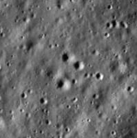
Almost everywhere i look in Von Karman southeast of the central peak the surface is characterized not only by the expected craters but also by a multitude of small troughs or valleys. This scene is about 4 km wide:
|
Hazard avoidance should allow CE4 to land in a level spot, but traverse planning may be interesting. I will not speculate as to the origin or depth of these features at the moment.
Phil
EDIT - 7 January - These grooves are further west than the actual landing site. Our area is free of them.
Posted by: Explorer1 Jan 3 2019, 02:46 AM
Unconfirmed social media reports of a successful landing at 2:26 UTC!
Presumably downloading the landing footage before any official announcement on state media (what I would do to maximize public outreach).
Posted by: Hungry4info Jan 3 2019, 04:24 AM
Official Chinese media are reporting successful landing.
Posted by: charborob Jan 3 2019, 04:25 AM
Landing announced on Xinhuanet http://www.xinhuanet.com/english/2019-01/03/c_137716800.htm
Posted by: Hungry4info Jan 3 2019, 04:59 AM

|
Posted by: nprev Jan 3 2019, 05:07 AM
Remarkable. Congratulations to China!
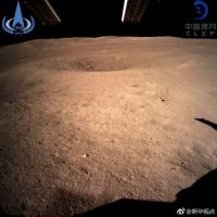
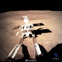
Posted by: Explorer1 Jan 3 2019, 05:08 AM
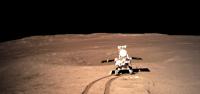
First surface image from the far side. A historic achievement!
Nearby crater and distant hills, should make finding the location easy enough; LRO should pass over the area on January 4th from what I've read.
Another image of the landing legs on social media; I can't find the original so I won't link it yet.
Video here (skip to 1:11 for apparent real time descent imagery, should make it easy for our resident cartographer to pinpoint the area )
https://krcom.cn/2656274875/episodes/1042194:4324354331200641
Posted by: Sym05 Jan 3 2019, 06:25 AM
Smartphone screenshot of CCTV 13 news cannel. 14:00 Beijing time edition. Screen in the control room shows the expected landing zone and expected landing point (only one decimal) 177.6 E, 45.5S

|
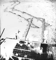
Posted by: Phil Stooke Jan 3 2019, 08:06 AM
Okey-dokey, here we go.
These are the views from that landing video:
|
|
This is an overlay of the landing site image posted just above this, overlain on a Quickmap image of the area:
|
Zooming in, the area looks like this:
|
And here two frames from the video are located.
|
That points to the approximate site. No doubt more tomorrow.
Phil
Posted by: Phil Stooke Jan 3 2019, 08:22 AM
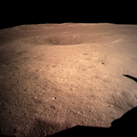
One other comment - the hills on the horizon in the one surface view we have are south of the lander. They are part of the rim of Von Karman, not the central peak. The direction of lighting in the image clearly shows that this must be looking south.
Phil
|
Posted by: Webscientist Jan 3 2019, 08:59 AM
Congratulation to CNSA and the engineers!
Surprised! I don't see a lot of stones in the first view and the surface seems to be particularly soft with a lot of dust.
It looks like dry clay (in a windy day), the kind of clay you find in Roland Garros for instance! 
Posted by: Baywa Jan 3 2019, 09:16 AM
What makes you think so? In https://krcom.cn/2656274875/episodes/1042194:4324354331200641 (link provided by Explorer1)at 0:21, from looking at the features that's von Kármán crater (I compared with the Virtual Moon atlas).
Thomas
Posted by: Thorsten Denk Jan 3 2019, 09:33 AM
Thomas
It's just one out of five points from a list of possible reasons why the calculations in post #76 are not correct.
It was written before the actual landing.
Now (after the landing) we know that this point is not the reason.
In any case, congratulations to the Chinese for the successful landing!
Thorsten
Posted by: Baywa Jan 3 2019, 10:25 AM
OK - so I mixed up the OR and the AND operator. But I would really, really want to figure out what actually happened starting at orbital insertion and ending with the landing approach. For example, maybe they changed the inclination of the orbit?
Thomas
Posted by: charborob Jan 3 2019, 11:03 AM
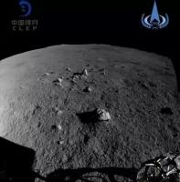
Photo of the landing pad on the Moon (http://en.people.cn/n3/2019/0103/c90000-9534393-7.html)
Posted by: Sym05 Jan 3 2019, 01:22 PM
From twitter:
https://twitter.com/Cosmic_Penguin/status/1080799826621587456?s=09
"Based on the few descent photos available right now someone in Chinese social media has provided finding charts for #ChangE4. (https://t.co/UiIjI3ngKY) Maybe someone here can get rough landing coordinates of it from the photos below?"
Original post on Weibo (Chinese language)
https://m.weibo.cn/status/HagktpCG8
Posted by: wildespace Jan 3 2019, 03:59 PM
Phil
|
|
I think the view is towards the largest crater in the immediate vicinity, to the east/south-east of the lander: http://bit.ly/2F5NB9U
P.S. QuickMap is strugging to serve so many requests today!
Posted by: Hungry4info Jan 3 2019, 04:42 PM
Yutu 2 deployment.
|
|
Posted by: tolis Jan 3 2019, 05:13 PM
My..that was quick!
A somewhat pedantic comment on Phil's earlier remark about viewing directions (Phil, please correct me if I messed up somewhere).
It is true that the direction of lighting implies that the mountain ridge on the horizon must be south of the lander and therefore part
of the rim of Von Karman, rather than its central peak, but this inference takes also into account the addiitonal
knowledge of time of (lunar) day. If the landing were to have taken place near local sunset, witnessing the same shadow direction
right after landing would imply a northwards view.
Further on the issue of mountains, I recall from looking at pictures of the Von Karman floor posted earlier with the likely
location of Ch4 in it that there is a "positive relief feature" just north of the landing site which >should< be closer
than either the central peak or the crater rim of VK. It would be interesting to see what that looks like from ground level.
Looking forward to those 360 deg panoramas!
Posted by: mmatessa Jan 3 2019, 05:18 PM
Rover/no-rover
|
Posted by: Steve G Jan 3 2019, 05:38 PM
The fact that you can see so far in the distance also indicates they have landed on a slight rise. Reminds me of the view from Stone Mountain on AS16.
Posted by: Phil Stooke Jan 3 2019, 08:11 PM
This is my interpretation of the view to the south and the crater rim - south up in the LROC wide angle mosaic. The rim is about 40 km away and the highest peak is 3 km above the plains. I wouldn't say it's 100% certain but I like it better than an interpretation where the relief is a nearby crater. I agree with Steve G that we are on a local rise. Sadly, not enough detail in the middle distance for an exact location yet.
Tolis, you are right about the time determining the direction if you base it on shadows, but we know the landing was mid-morning.
Phil
|
Posted by: John Moore Jan 3 2019, 08:37 PM
From mmatessa's animation, view of the shadows between each - Rover/No Rover - are shortening (note the change at the two small rocks nearby).
The sun is rising over the landed area, so, we must be viewing south as Phil suggests (if elsewise, looking northwards, the shadow changes would be reversed). The 'local sunset' mention may be due to that
of viewing the Moon from the Nearside, and anyways, why conduct a mission where the Sun is setting on the Farside, but more when it is rising - availing of its full potential to power-up (using the solar panels) the lander/rover overall.
John
Posted by: Decepticon Jan 4 2019, 01:59 AM
The pictures posted by China's media look like false color?
Are they using different color filters to bring details out?
The moon looks more like mars in the media released images.
Posted by: Phil Stooke Jan 4 2019, 03:23 AM
The surface images we have seen so far are just from a small monitoring camera - Chang'e 3 had several as well. The color is not accurate. We should soon see images from the much better cameras on the lander and rover, and they will have more realistic color.
Phil
Posted by: jccwrt Jan 4 2019, 10:20 AM
Edit: nevermind, wrong year. That will teach me not to post on no sleep...
Posted by: MahFL Jan 4 2019, 10:41 AM
https://twitter.com/siyuan0zhao/status/1080671203315122177?s=19
That was the previous mission.
Posted by: charborob Jan 4 2019, 11:49 AM
Yutu 2 moved a few meters (http://www.cnsa.gov.cn/n6759533/c6805086/content.html):

|
Posted by: Station Jan 4 2019, 12:47 PM
short animation concerning recent lunar events 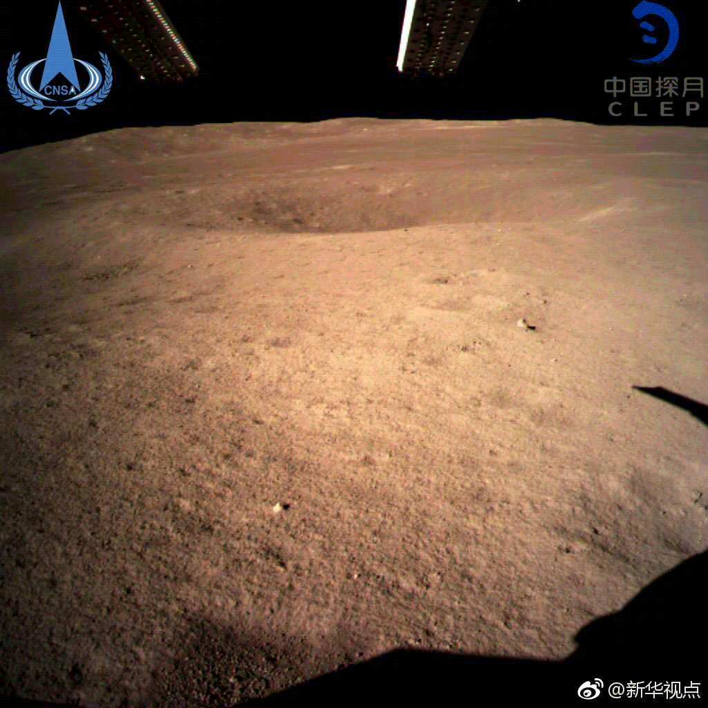
Posted by: Station Jan 4 2019, 12:53 PM
I've just created the comparison of the Change 3 and 4 mission landing sites, well, first impression - very similar thanks to neighbouring small crater next to the lander's ramp 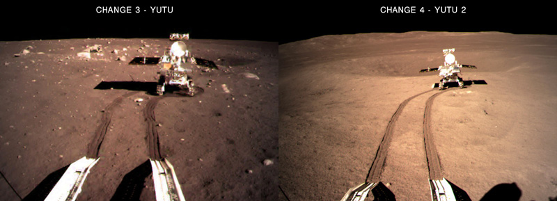
Posted by: Steve G Jan 4 2019, 02:03 PM
I'm amazed by the lack of rocks. We'll have to wait for a full panorama to see what the rest of the landing site is like.
Posted by: neo56 Jan 4 2019, 02:59 PM
Animation showing the deployment of Yutu 2 rover The second picture is a low resolution caption of Chinese TV.
I desaturated the 4 pictures to obtain more realistic colors of Moon surface.
|
Posted by: Hungry4info Jan 4 2019, 04:48 PM
Anyone have any more information about https://twitter.com/LiuyiYiliu/status/1081163287159496706?
Edit: "After making the historic first tracks on the far side of the Moon, the Yutu-2 rover is going to enter "noon break" sleep mode til January 10, according to China's lunar program, as a precaution for high temperatures "

|
Posted by: Phil Stooke Jan 4 2019, 05:54 PM
The first Yutu did exactly the same thing. They may also need to wait for the lander's camera to provide a good panorama to help plan the traverse.
Phil
Posted by: charborob Jan 4 2019, 05:57 PM
Edit: "After making the historic first tracks on the far side of the Moon, the Yutu-2 rover is going to enter "noon break" sleep mode til January 10, according to China's lunar program, as a precaution for high temperatures "
If you translate what is said in the link that I pointed to in my previous post (here it is again http://www.cnsa.gov.cn/n6759533/c6805086/content.html), that's what it says:
"After that, the No. 4 will usher in the high temperature test of the Lunar New Year. The patrol (= Yutu 2 rover) will enter the “noon break” mode and is expected to wake up on January 10." (Google translation)
Posted by: scalbers Jan 4 2019, 09:00 PM
Kind of neat to think of the rover taking a noon break when from the Earth's near-side perspective there's a new moon about that time.
Posted by: Hungry4info Jan 5 2019, 03:26 AM
https://mp.weixin.qq.com/s/7Eg-h_25VBO6_QjJiO_QIg
The three five-metre antennas for the radio spectrometer have been deployed, the German LND neutron dosimeter is working, and the lander's terrain camera is sending back images.
Posted by: Julius Jan 5 2019, 09:32 AM
Is the brown colour of lunar soil accurate? Is it dependent on lighting conditions on sun angle over horizon?
Posted by: MahFL Jan 5 2019, 10:04 AM
No, it's a low res simpler contex camera, the Moon is not red.
Posted by: Webscientist Jan 5 2019, 01:49 PM
It is surreal to observe a surface devoid of any significant stones or rocks.
I imagine that the area is particular since we are in a large crater which appears quite flat from outer space. A large amount of volatile material resulting from the impact event must have filled the area. That's probably why, to a certain extent, the surface seems so cottony with a significant layer of dust (marking of the wheels).
I anticipate that we would have to dig to find the rocks.
I may be wrong but that's my impression at first sight.
Posted by: Steve G Jan 5 2019, 03:51 PM
There are examples during the Apollo missions with few rocks and boulders. This very excellent Apollo 14 picture illustrates that. (I took the liberty to remove the extremely annoying Reseau crosses.)

|
Posted by: wildespace Jan 5 2019, 04:59 PM
Phil
|
|
I'd like to share this image posted at the Above Top Secret forum (where genuine discussion about space missions does happen), I think this guy did some excellent detective work:

|
(orbital image is from Chang'e 2)
Source: http://www.abovetopsecret.com/forum/thread1225796/pg4#pid24085188
Posted by: Phil Stooke Jan 5 2019, 06:37 PM
That confirms the interpretation given in post #103 above in this thread. I am really looking forward to seeing the full horizon. I don't know if the central peak will be visible but it might be. A small hill 10 km north might be as well.
Phil
Posted by: Hungry4info Jan 5 2019, 07:34 PM
I took some of the frames Phil gave us from that control room footage and tried to stabilize the last couple of them, hoping to get an idea of where to look based off that. The imagery in the original video appears to move around in some areas and I'm not sure if this is just my own inability to follow the surface features or if the lander's autonomous hazard avoidance kicking in. Here's an animation of the last two frames, stabilized.

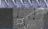
|
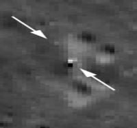
Based on this, and comparing it to imagery of the landing site, and knowing that there's a ~15-20ish metre crater just to the south of us, and assuming the lander continued all the way to the surface after the above animation without changing its course to avoid an obstacle, I think there's a good chance that the landing site is within a few metres of this location (marked with an X). Lat: -45.46738, Lon: 177.59876
|
It's not a perfect match, but I think it's a good candidate based on the above argument. I'm not very well satisfied with the difficulty in matching surface images seen in the rover deployment camera with what we see in this LROC image, but perhaps this can be explained with changes in illumination, and the difficulty in teasing out surface topology in a non-stereoscopic image at a more extreme viewing angle.
Posted by: Phil Stooke Jan 6 2019, 01:04 AM
I have been trying to make a match without success. This is as good as anything I had come up with. I was looking a bit further west.
http://m.bldaily.com/china/news/p-373798.html
A picture near the bottom of this report shows tentative plans for the early operations. It exactly mirrors what was done by the previous rover. Drive around the lander and image it from several positions.
Phil
Posted by: wildespace Jan 6 2019, 03:47 AM
After being deployed and travelling out for a short distance, Yutu-2 rover turned around 180 degrees for this photo:
|
(Source: http://www.abovetopsecret.com/forum/thread1228337/pg1 )
Hopefully, that means a photo of the lander coming up soon.
Posted by: John Moore Jan 6 2019, 05:22 PM
About the size of the crater - just a bit of supposition: let's say the rover travelled some 12 metres from the lander, and stopped some 7 metres before the edge of the crater, and then assume that the
wingspan of the rover is some 2 metres in all (not sure, the stats are probably available somewhere), then that would put the size of the crater at about ~ 22 metres (+/- a metre) in diameter.
If it is, in approximate, round that estimate, that's a pretty small crater to be looking for if just using the Quick-Map alone pushed at its max zoom. Therefore, one might have to go down the NAC route.
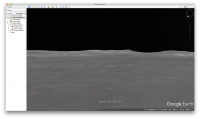
Posted by: scalbers Jan 6 2019, 06:06 PM
A somewhat similar view in Google Earth (switched to the moon).
|
Here is a video from Kaguya orbiting over Von Karman and Leibnitz, looking northward. Best view of the landing site is at about 0:27 into the video.
https://www.youtube.com/watch?v=D5oIoZkHYmY
Posted by: JRehling Jan 7 2019, 10:23 PM
I imagine that the area is particular since we are in a large crater which appears quite flat from outer space.
Material on a lunar plain is almost always either the reworked result of an impact locally or material flung long-distance from other impact(s). The material flying due to each impact will have its own function of distribution of size vs. distance (with, as we see looking at ray craters, some radial variation as well). To see a rockless site just tells us that somewhere in that function for some impacts is dust without rocks. But I wouldn't expect that to be, necessarily, a function of the immediate local history it could be telling us about the impacts that occurred tens and hundreds of km away, and in what sequence.
Posted by: wildespace Jan 8 2019, 07:17 AM
Is the floor of Von Karman crater basically one big lava flood plain? That would explain the relative smoothness and the pits and groves observed in many place (collapsed lava channels?).
BTW, the nearby Leibnitz crater has some nice https://en.wikipedia.org/wiki/Lunar_swirls, caused by local magnetic fields deflecting solar wind. I wonder if Von Karman crater had some localised magnetic activity.
Posted by: threadworm Jan 8 2019, 03:46 PM
I'd forgotten I had an account here!
I made the image identifying the features in the background of the lander image
I've also been busy downloading the Chang'e-2 data for the crater, and have made a 3D image of the hills in the distance, which you can get here:
https://www.dropbox.com/s/b0m5vb93rgozqkk/von%20karman2.zip?dl=0
Once extracted the open the index2.html file in either Microsoft Edge of Firefox (it won't work in Chrome). The base DEM layer is 20m resolution, and the photographic layer is the 7m resolution georectified (selenorectified?) on the 20m image. Here's a view from it:
I also did one from the Kaguya data:
https://www.dropbox.com/s/7je2v4ymzx1vhr5/von%20karman.zip?dl=0
same process for opening but this time the file is called index.html
Happy exploring
Posted by: Phil Stooke Jan 9 2019, 04:45 AM
Very nice!
I have been going nuts, or as my kids might say, more nuts, trying to find the site in pre-landing LRO images. Not easy when we have so little to compare with the LRO image. There was supposed to be a new LRO image on about the 6th, but possibly it missed the site (???). This article:
https://www.businessinsider.com/china-far-side-moon-landing-change4-site-map-2019-1
says we have to wait until the end of the month.
For a while I thought I had a great clue. This tweet:
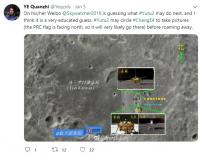
|
(Quanzhi was one of our students) shows somebody's idea of where the rover might go in the first week or so. Enlarging the middle of it we find this map:

|
For a while I thought the background might be a mission map made from descent images and I wasted many an hour looking for that pattern of craters. Then it dawned on me - it's the Chang'e 3 site flipped north-south! So still no idea.
Phil
Posted by: Phil Stooke Jan 9 2019, 07:33 PM
https://www.weibo.com/ttarticle/p/show?id=2309404326646026003185
This article was linked from the CLEP Weibo account. Link to it in Chrome to get a rough translation. It does not have much new in it but talks about the reason for taking a break in the middle of the day, to protect components from overheating. It confirms the lander is continuing to operate.
Chang'e 3 and Yutu did the same thing - a nap in the middle of the first day as a precaution against the noon heat. And it did it at the same place, after the second drive. If my memory is correct they did not plan to do this in the second day, but that is roughly when Yuyu stopped working. At the time I thought it might have been a heat-related problem, but we know now that it was an electrical fault instead. So it will be interesting to see if they do that again in lunar day 2.
The Lunokhods also took breaks around noon, but that was more to do with visibility for driving.
Phil
Posted by: Hungry4info Jan 11 2019, 02:07 AM
Panoramas!
http://www.xinhuanet.com/english/2019-01/11/c_137735844.htm
https://www.weibo.com/ttarticle/p/show?id=2309404327207332888406

|
|
|
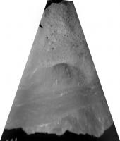
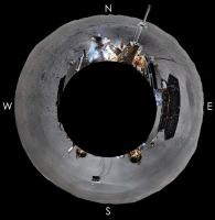
Posted by: Phil Stooke Jan 11 2019, 02:56 AM
At last! They are great. Here's a circular version in my geometry. Much more on the horizon than I expected.
Phil

|
Posted by: Phil Stooke Jan 11 2019, 03:00 AM
And that takes us immediately to the landing site:

|
Phil
Posted by: charborob Jan 11 2019, 03:06 AM
High resolution panorama:
http://www.cnsa.gov.cn/n6758823/n6758842/c6805147/content.html
Posted by: Explorer1 Jan 11 2019, 03:14 AM
Wow! Right between those craters; my congratulations to the landing hazard avoidance team! Great rim views too.
Strange to think this is a landscape (unique in the solar system and probably the galaxy!) where Earth is never visible, yet its right next door....
Here's a rotated version of the vertical (Chinese-style?) panorama charbob posted:
|
|
Posted by: neo56 Jan 11 2019, 06:44 AM
I made a 360x180 version of the panorama and put it https://roundme.com/tour/350106/view/1179570.
Posted by: threadworm Jan 11 2019, 09:18 AM
Fantastic stuff - great detective work all round
Just shows how deceptive distances are - I'd drawn some projection lines to the edge of the crater along the rover tracks and come up with a measurement of about 16m across for the crater immediately to the south but it looks to be more like 25m.
I've been looking at other sources for surface images and from what I can tell Japan's data is either too patchy or too dark to get a good look. India does have a swathe covering the crater but it is some way to the west of the landing zone, but if anyone wants to download it it's on orbit 3021 from the Chandrayaan site.
https://issdc.gov.in/CHBrowse/index.jsp
If you aren't registered you won't be able to browse to it, hence no direct link. It does at least show the craters to the north and south. There is another pass covering the far east of the crater, but frustratingly it's yet another one of those that is shown on their map but has no link and doesn't seem to be listed when you search for it.
Their own Chang'e-2 imagery barely catches the landing site.

|
Posted by: threadworm Jan 11 2019, 09:45 AM
The full resolution video has now been released:
http://www.cnsa.gov.cn/n6758823/n6758838/c6805157/content.html
Would have saved us a lot of time
Here's a screenshot from the final stages.

|
Posted by: wildespace Jan 11 2019, 10:55 AM
Yass! Now we see the landing site properly.
Here's 360-degree panorama from the master Andrew Bodrov: http://www.360cities.net/image/first-lunar-far-side-panorama-change-4
Posted by: GoneToPlaid Jan 11 2019, 12:02 PM
Attached is an enhanced LRO image of the Chang'e-4 landing site.

|
Posted by: charborob Jan 11 2019, 12:40 PM
It looks like Yutu-2 made an almost 180-degree clockwise turn around the lander in order to photograph the side of it showing the Chinese flag:
http://www.cnsa.gov.cn/n6759533/c6805166/content.html
Posted by: elakdawalla Jan 11 2019, 06:12 PM
Here is the mp4 of the landing. As far as I can tell, it contains all the full-resolution frames in order with numbers and time stamps. The computer I'm working on today choked when I tried to export all the frames using Photoshop, or I would've posted the whole archive for you. If someone is able to do that, I'd be glad to host them on our S3 server.
https://planetary.s3.amazonaws.com/assets/images/3-moon/2019/ce4-descent-video-clep-cnsa.mp4
Credit: CNSA / CLEP
Posted by: stevesliva Jan 11 2019, 06:48 PM
Amazing how fractal the cratering is. Well, amazing when I realize I have no idea of vertical height when looking straight down. Otherwise I suppose it's about to be expected.
Posted by: neo56 Jan 11 2019, 08:42 PM
Phil, where did you download this picture? I'm on the QuickMap LROC website but the resolution is not as good as your picture.
Posted by: charborob Jan 11 2019, 08:44 PM
I tried superposing Yutu-2's latest position on part of the panorama:
|
|
Posted by: Phil Stooke Jan 11 2019, 09:07 PM
"Phil, where did you download this picture? I'm on the QuickMap LROC website but the resolution is not as good as your picture."
This is the original image data, not the version used in Quickmap which is not nearly as nice.
In Quickmap you can use a selection tool to outline a polygon, and get a list of all LRO images crossing that area (the list is not really the full data set, some frames are not included depending on when it was last updated). Each item in the list is a link to a page which lets you zoom in on the image or download the raw data. I download the CDR 16 bit version.
You can also search for LRO camera images from their website:
http://wms.lroc.asu.edu/lroc
That is more likely to have everything currently available.
My next step is to use the landing video images to supplement the LRO coverage.
Phil
Posted by: HSchirmer Jan 11 2019, 10:05 PM
I've heard from family who flew over the Atlantic, Pacific and Gulf of Mexico that ocean waves are fractal.
You can't tell vertical height by looking down, waves at 10-feet up look just like waves at 100-feet up, which look just like waves at 1,000-feet up. That's why, when you're on a parachute, you don't look down; you look at the horizon to judge altitude, and you don't release the parachute harness until your feet hit the water.
- Interesting whether the fractal dimensions of cratering might constrain the atmospheric properties of moons and planets?
Curious- are there any papers on "fractal dimensions of lunar craters" addressing the range of sizes?
Posted by: neo56 Jan 11 2019, 10:07 PM
Thanks Phil. The resolution of images on the quickmap was enough to locate the landing site.
Here is a montage I did to help locate it.
https://www.flickr.com/photos/thomasappere/46653256822/sizes/o/
And my guess on the orientation of Chang'E 4 based on the shadows and position of craters:
|
Posted by: wildespace Jan 11 2019, 11:36 PM
For everybody's convenience, here's a high-quality NAC strip of the area:
http://wms.lroc.asu.edu/lroc/view_lroc/LRO-L-LROC-2-EDR-V1.0/M134022629LE
The landing site is slightly below the centre of the image strip.
200% scale crop:
|
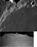
Posted by: Phil Stooke Jan 12 2019, 06:25 PM
I know several of us were looking for the landing location in images like these before we saw the panorama. I looked at this place among many others, but I thought the hazard avoidance system would divert the lander away from a place like that which is surrounded by craters. There are nice smooth spots close by, to the west or northeast. But it's all about the scale of the hazard avoidance, I suppose. We did get a nice level area between the craters.
Phil
Posted by: Phil Stooke Jan 12 2019, 10:23 PM
While waiting for news of any activity on the 12th, here is a comparison of horizon features between the panorama and an LRO wide angle (heavily processed) image.
The central peak is visible, but Ba Jie crater is not. More than half of the horizon is the rim of Von Karman. The small hill about 10 km north of the lander, which might make a good target for the traverse, is probably visible as a low ridge labelled X here.
Phil
|
EDIT: My crater 'C' might be the one higher up on the rim of the main crater, with ridge D adjacent to it.
Posted by: wildespace Jan 13 2019, 08:19 AM
Phil
The landing footage shows the craft pausing briefly when over that location, seemingly detecting an even space between those craters, and "making the decision" to land there. Simple and effective, just like what Chinese would do.
https://www.youtube.com/watch?v=JJi_YEubKCY&t=1m54s
Posted by: wildespace Jan 13 2019, 08:46 AM
"The space probe is moving south across the Mün"
Excellent video processing and analysis here. https://www.youtube.com/watch?v=unEbg_dt3DM
Posted by: Huguet Jan 13 2019, 02:02 PM
Panoramas from chang'e-3 and chang'e-4. I expected the number and pattern of the impact craters to be more diferent beetween the two landing sites, it apears to have double of small craters (less than 1 meter) on the darkside.
|
|
Posted by: Thorsten Denk Jan 13 2019, 02:19 PM
I think we have to be careful with generalizing
"lunar farside" = "heavily cratered" = "this landing spot".
The first "=" is generally true,
but the specific Cháng'é-4 landing site
is a lava flooded crater and hence
should rather have properties of (near side) Mare areas.
Untypical for far side in general.
The difference in craters should be more indicative
to age than to "near" vs "far" side.
Thorsten
Posted by: Steve G Jan 13 2019, 08:03 PM
Chang'e 3 landed on lunar maria, Chang'e 4 on lunar highlands, which is a big difference especially in age, so I'd expect more craters in a highland area. Of course, that depends on the age of the basin in Von Karman.
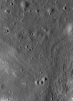
Posted by: Phil Stooke Jan 14 2019, 05:51 AM
Von Karman is filled with basalt lava flows, probably not very different in age than typical mare basalts on the Earth-facing side of the Moon. Von Karman is in the highlands but its floor is not highland, in other words. But these things are deceptive. Because highland surfaces are older they have a thicker regolith, and it affects the survival of small craters during impact-generated siesmic shaking. Sometimes highland surfaces can look smoother and younger just because their craters are more softened by shaking. A slope helps that process, so the rolling topography of highland areas is ideal for erasing craters in this way.
Here is an example from Flamsteed, the almost completely buried crater in which Surveyor 1 landed in 1966. Mare basalt at the top, low relief highland surface at the bottom. The image is about 800 m wide, 1.9 south, 43.0 west. More craters in a given area on the mare, but the highlands are older. At this scale they just don't preserve craters. Larger craters are not erased this way so at broad scales the basic rule 'older = more craters' is true.
Phil
|
Posted by: kenny Jan 14 2019, 07:30 PM
Lovely little color video of Yutu-2 driving away from the Chang'e-4 lander and executing the 180 degree turn ...
https://www.youtube.com/watch?time_continue=56&v=1ZmYX5nVwLc
Posted by: Hungry4info Jan 15 2019, 06:42 AM
China's Chang'e-4 probe conducts first bio test on moon as first plant grows
https://news.cgtn.com/news/3d3d414f7949444d32457a6333566d54/share_p.html
Edit: From https://gbtimes.com/change-4-cotton-seeds-are-sprouting-on-the-far-side-of-the-moon Global Times article.

|

|
Posted by: GoneToPlaid Jan 15 2019, 09:03 AM
[quote name='Phil Stooke' post='243419' date='Jan 13 2019, 09:51 PM']Von Karman is filled with basalt lava flows, probably not very different in age than typical mare basalts on the Earth-facing side of the Moon. Von Karman is in the highlands but its floor is not highland, in other words...
Phil
Very true. In fact, where Chang'e-4 landed is approximately -6km relative to the moon's mean radius. Definitely not highlands, and instead is lowlands within the huge Von Karman crater floor.
Posted by: Phil Stooke Jan 15 2019, 06:41 PM
I have been following the discussion here:
http://www.9ifly.cn/thread-5819-70-1.html
(in translation) which seems to be saying that a power failure has ended the biological experiment. Does anyone have any other information?
Phil
Posted by: Explorer1 Jan 15 2019, 08:03 PM
This (English) article says they were powered down for sunset (i.e. the experiment would not go past lunar night).
https://news.cgtn.com/news/3d3d414f7949444d32457a6333566d54/share_p.html
Posted by: Phil Stooke Jan 15 2019, 08:38 PM
OK, that's good. I had thought it was supposed to work through the lunar night with warmth and artificial light, though I know it piped in natural light during daylight. It does seem like a useful next step would be to allow longer operation on a future mission. Maybe that is more suited to polar missions, which we know are in the plan.
Phil
Posted by: wildespace Jan 16 2019, 11:30 AM
What the landing site will look in early morning. High incidence angle (86.68 degrees) view from http://wms.lroc.asu.edu/lroc/view_lroc/LRO-L-LROC-3-CDR-V1.0/M178833263LC
|
Posted by: Phil Stooke Jan 17 2019, 03:37 AM
|
I saw this picture tweeted on the 11th or 12th and then couldn't find it again to save it. Now I found it on this site (near the bottom):
http://py.qianlong.com/2019/0116/3064840.shtml
It is from the last position on the first lunar day, looking back on the tracks from that day's drive. Does anyone have a better version of it?
Phil
Posted by: kenny Jan 17 2019, 10:45 AM
According to the Google image-matching search function, that is the only version of that image on the internet at the moment.
Google's best guess for the subject of that image is a River Clyde steamer !
Posted by: Huguet Jan 17 2019, 01:23 PM
Yutu 2 will have a hard time avoiding all that craters, he will need to be making adjustments at almost every meter.
"From the images sent back from Chang'e 4, we can see the area surrounding the probe is dotted with craters of different sizes, and it's very difficult for the rover to drive in the region," explained Sun Zezhou, chief designer of the Chang'e 4 probe, according to Xinhua.
"We'll try to find the relatively safe areas and make a reasonable plan for the route of the rover based on the images taken by it," Sun said, adding, "we haven't found any insurmountable obstacle in the region."
Posted by: John Moore Jan 17 2019, 08:31 PM
Looks like the top-left (squiggly) tracks are those where it stopped at the crater south (classic image, well-published at this stage), the rover did a 180 deg there (and more), and from the current image,
we're still looking back southwards as the Rover travelled north after two wheel-abouts (the Lander would be to the left - some several metres away).
Have a simulated image put together of the possible track, but it would have been poor to post.
The stopped-off position of the Rover is well within the lunar night-time -175 deg C temperatures now; waiting for further activation round the 28/29 Jan 2019. Fingers crossed.
Posted by: Phil Stooke Jan 22 2019, 11:27 PM
This must be the first journal publication to come out of Chang'e 4 operations.... the DOI or title will lead you to the journal website, from which the paper, in English, can be downloaded free by anyone.
Phil
Di, K. C., Liu, Z. Q., Liu, B., Wan, W. H., Peng, M., Wang, Y. X., Gou, S., Yue, Z. Y., Xin, X., Jia, M. N. and Niu, S. L., 2019. Chang'e 4 lander localization based on multi-source data. Journal of Remote Sensing, v. 23, no. 1, pp. 177-184. DOI: 10.11834/jrs.2019015.
EDIT - here is the direct link to the journal site - I should have given it in the first place. Open in Chrome to translate.
http://www.jors.cn/jrs/ch/reader/view_abstract.aspx?file_no=ygxb-23-1-dikaichang
Posted by: Explorer1 Jan 30 2019, 02:55 AM
Looks like the lander and rover have woken up (judging from in the know social media accounts)! First science data release February 1st, apparently.
Posted by: charborob Jan 31 2019, 05:16 PM
http://www.xinhuanet.com/english/2019-01/31/c_137789743.htm
Posted by: tolis Feb 1 2019, 11:42 AM
One might wonder what is the contribution of the Earth, as a reflector of solar radiation, to lunar surface temperatures during the night
given that it has (i) 4x4 = 16 times more surface area, and (ii) a higher albedo than the Moon.
Anyone care to take up this exercise?
Posted by: ngunn Feb 1 2019, 12:12 PM
An interesting question (though maybe not for a farside mission thread). To the reflected solar you would need to add the Earth's own thermal IR
Posted by: tolis Feb 1 2019, 12:20 PM
Perhaps it is relevant to farside surface conditions insofar as the absence of the Earth in the sky would result in a lower nighttime temperature compared to the nearside (everything else being equal of course).
Posted by: ngunn Feb 1 2019, 07:19 PM
OK I've done some very crude calculations based on black bodies and a nominal night surface temperature of 100K and I'm getting answers on the order of 0.1K.
Posted by: tolis Feb 2 2019, 01:20 AM
I'd say that is ~100x less than anything that would contribute to the nighttime temperature in a significant way.
Thanks.
Posted by: Station Feb 3 2019, 03:40 PM
Here goes a new image taken from Yutu2. Apparently rover took it after driving few meters bit forward to NW.
Posted by: tolis Feb 3 2019, 04:18 PM
The tip of that vertically-erected antenna is sitting some 7m above the surface (say 5m for the antenna, 2m for the lander deck). Would that constitute the tallest
articifial structure on the Moon at the moment?
Posted by: Phil Stooke Feb 3 2019, 06:25 PM
Yes, I think it would be the highest structure.
The picture is newly released, and might be newly transmitted, but it was taken before sunset on the previous lunar day (based on the direction of the shadow). I have not seen any pictures or evidence of driving on this second lunar day.
Phil
Posted by: Steve G Feb 3 2019, 10:18 PM
What spectacular scenery! Will the cameras on the lander have survived the lunar night? I believe that on Chang'e 3 the colour cameras were not protected and did not function afterwards.
Posted by: Station Feb 5 2019, 09:39 AM
Newly released image (from first "sol") taken by Yutu2 shortly after deployment onto lunar surface.
Posted by: Phil Stooke Feb 6 2019, 06:28 PM
http://www.9ifly.cn/forum.php?mod=viewthread&tid=5819&extra=&page=89
This link is to the 9ifly forum, where a user has posted a map of Von Karman showing names "approved by the IAU" (the IAU planetary nomenclature site at USGS does not show it but they may not have updated yet, perhaps due to shutdown issues).
Three craters around the landing site take names from the 'summer triangle' of bright stars, Vega, Altair, Deneb but using their Chinese names. The landing site is Statio Tianhe, where Tianhe means Milky Way. The names refer to the story of the Weaver and the Cowherd, lovers separated by the Milky Way and allowed to meet by crossing on a bridge formed of magpies, the same story from which the relay satellite gets its name. Finally the central peak is named Mons Tai after Taishan, a mountain in China.
Phil
Posted by: volcanopele Feb 6 2019, 06:31 PM
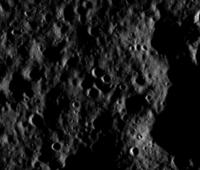
LROC got an oblique image of the landing site last week:
http://lroc.sese.asu.edu/posts/1090
Posted by: Phil Stooke Feb 6 2019, 07:20 PM
Spectacular, but I would hope a vertical view was obtained on a later orbit!
Phil
Posted by: Phil Stooke Feb 9 2019, 07:05 AM
Well, a few orbits later but still the same day, a less oblique view:
http://lroc.sese.asu.edu/posts/1091
Lander and rover both visible, just. A vertical view on the next day is probably still to be released. Here is a modified view of the landing site:
|
Posted by: Station Feb 11 2019, 06:22 AM
It's a pity there is no information about second lunar day on the surface. I wonder if the mission is in any trouble and therefore chinese officials don't want to give any further details about the encountered problems...
Posted by: Phil Stooke Feb 11 2019, 07:28 AM
We have information about the first few (Earth) days of the second lunar day as shown on the map. Since then there has been a big holiday period coinciding with New Year in China, and many government offices etc. will have been closed. We might learn more this week. But no reason to expect a problem at this point. Also, a COSPAR meeting coming up where news may be released.
Phil
Posted by: Paolo Feb 15 2019, 06:05 AM
welcome to Statio Tianhe
https://www.iau.org/news/pressreleases/detail/iau1901/
Posted by: Olympusmonsuk Feb 15 2019, 10:19 PM
Vertical LRO view of Chang'e 4 landing site-Statio Tianhe
http://lroc.sese.asu.edu/posts/1092
Posted by: Station Feb 20 2019, 07:58 AM
Hi,
Any further information about CH-4 mission status? Some chinese forum? This continuing lack of info is very disturbing. I wonder if something went wrong and chinese mission's directors don't want to publish it online untill resolution is found...
Posted by: Paolo Feb 20 2019, 08:31 AM
there was a very nice full moon this night, which means that it's night on the farside and CE4 and Yutu are sleeping peacefully
Posted by: Station Feb 20 2019, 08:47 AM
I know CH4 and Yutu2 are resting now but I meant SOL-2 which already passed and there is no single photo from this day. (btw. we had plenty of photos, movie clips etc from first SOL so I wonder what's the cause of current situation.).
Posted by: Thorsten Denk Feb 20 2019, 07:31 PM
I've seen one new picture that seems to be from the second month. Maybe.
It's from https://twitter.com/LaunchStuff/status/1096354988765384705 linking to https://mp.weixin.qq.com/s/DILOVmbCJPL_oh1Ix13Qdg.
Thorsten
Posted by: Phil Stooke Feb 27 2019, 09:33 PM
This chinese forum page:
http://www.9ifly.cn/thread-5819-98-1.html
includes a route map for the first 2 lunar days. I assume it is based on real data and will update my map shortly. Any further information would be much appreciated.
Phil
Posted by: Phil Stooke Mar 4 2019, 06:14 PM
https://www.weibo.com/5386897742/HjniODYsW?type=comment#_rnd1551722722531
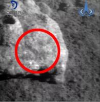
New images in a post on Weibo. Open in Chrome to get a translation. One is from a 'hazard camera' (to use MER/MSL terminology) or ICC (Insight) type of camera, mounted low and very wide angle. It looks northwest with the central peak on the horizon. The rover is only about 7 m further from the last night resting place. The second image is a closeup of the rock in front of the rover taken by the camera in the infrared spectrometer instrument. It shows the IR target on the rock.
Posted by: John Moore Mar 4 2019, 07:33 PM
So, if during the first lunar day the Rover travelled some 44.185 metres, travelled some 75.815 metres during the second day, the third lunar day involved some travelling by the Rover of ~ 7 metres in all to the rock.
John
Posted by: Phil Stooke Mar 4 2019, 08:02 PM
Only the first half of the 3rd day, March 1 to 3, followed by the noon siesta we are in right now. They probably took quite a bit of that time to adjust the position of the rover to get the fixed field of view of the instrument pointing at the rock. And actually we don't know this is the only rock they have analyzed in these last few days.
The original Yutu only used the instrument on soils so pointing was not such an issue. It was heading for some light-toned rocks on the rim of the crater just north of the lander when the rover stopped moving, so the science team may have been planning a rock analysis that never happened.
Phil
Posted by: Paolo Mar 4 2019, 08:29 PM
It does not work for me. I land on the weibo login page
Posted by: Hungry4info Mar 4 2019, 08:51 PM
I occasionally have the same trouble. Here are the two referenced images (not modified, the image quality really is that low, clearly the post on Weibo was not the true original images).
|
|
Posted by: Phil Stooke Mar 10 2019, 08:44 PM
I don't know what happened with the above link, but it works fine for me.
Andrew Jones tweeted this:
https://twitter.com/AJ_FI/status/1104269021829128192
- giving some new images and a link to the source. The new images include a half-panorama taken at the end of lunar day 2, showing a group of small rocks which became the target of activities on the 3rd lunar day. If you go through the source you can piece it together: early in day 3 Yutu 2 moved on a dogleg path towards the rocks to put the VNIS (Visible and Near-Infrared Spectrometer) field of view on a small rock. The first attempt had the field of view just off the rock (Andrew did not reproduce that image, you have to go to the source to see it). The rover turned slightly and moved forwards and now the FOV was correctly placed. That takes us back to the images posted above.
Today, March 10th, Yutu 2 is waking up after a noontime nap.
Here is the panorama - patched with bits from the other images to cover sun glints etc. - and reprojected to show the area. My orientation might be slightly off but should not be too bad.
Phil
|
Posted by: Phil Stooke Mar 11 2019, 04:57 PM
This is the image showing the VNIS image that missed the target.
Phil
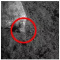
|
Posted by: John Moore Mar 11 2019, 08:36 PM
Third lunar night begins approximately on March 14, 2.30 UT, leading later to the fourth lunar day beginning approximately on 28 March 22.30 UT.
Note, above dates are related to terminator times over the landing site, not sleep-times/awakening-times of the Lander/Rover, which usually involves a day or two before or after the terminator dates occur.
Posted by: kenny Mar 16 2019, 11:06 AM
Nice summary of current status of Chang'e-4 here, as Yutu-2 attains its design lifetime...
https://spacenews.com/change-4-spacecraft-enter-third-lunar-night-yutu-2-reaches-design-lifetime/
Posted by: Phil Stooke Mar 25 2019, 06:07 PM
https://twitter.com/AJ_FI/status/1110035767697567746
Andrew Jones tweets a Chinese map and a nice picture of tracks. That was one of several track images shown in a presentation by Xiao Long at LPSC. I spoke to Long before his talk and he asked where I got the map information, as he didn't have access to it. I showed him the informal sites I had information from. In his talk he showed a redrawn version of my map! This new map solves that problem for Long, a proper Chinese map. I hope we will see this on a regular basis. Next I hope to see a few names for craters along the path.
Phil
Posted by: Phil Stooke Mar 25 2019, 10:24 PM
Here's another Chinese forum page:
https://club.6parkbbs.com/life2/index.php?app=forum&act=threadview&tid=15228936
This is notable for a very early traverse plan. A hexagon around the lander, about 10 m on each side. They could follow either the clockwise or counterclockwise paths around the lander, photographing it from the vertices of the hexagon before departing. The counterclockwise path is blocked by large craters so the clockwise path was adopted, but modified so there was no imaging from D, north of the lander. This is exactly like the original CE3 - Yutu plan, but flipped north-south. This time I am adding the map here:
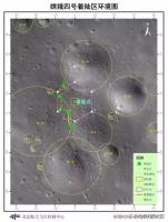
|
Posted by: Hungry4info Mar 29 2019, 07:30 PM
A paper in Nature that I can't access has some images.
https://www.nature.com/articles/s41561-019-0341-7
https://twitter.com/LaunchStuff/status/1111679252355784704 has the images attached, but there's not a lot of context.
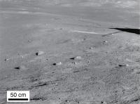
|
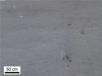
|
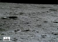
|
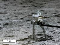
|
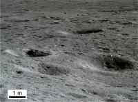
|
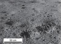
|
Posted by: djellison Mar 29 2019, 09:54 PM
The paper itself contains nothing of merit beyond those images really.
Posted by: Phil Stooke Mar 30 2019, 05:41 PM
I agree, just a summary of what the mission will do (at the 'uncover the secrets of the far side' level, not a day to day plan), not what it has done except for the nice new images.
Weibo has this story today:
https://www.weibo.com/ttarticle/p/show?id=2309404355633053836186
(Thanks to Andrew Jones for tweeting the link). It has new images, very compressed, including this one:
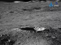
|
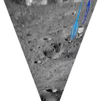
|
The hills show it was pointing north. The light shows it was taken at sunset, not dawn on day 4.
Phil
Posted by: fredk Mar 30 2019, 06:01 PM
In the upper right image (the one at very low phase angle) does the large rock near bottom have a blast shadow from landing? The short paper says nothing about it.
Posted by: Phil Stooke Mar 31 2019, 05:05 AM
No, the short paper says nothing at all, really. But I would be surprised if this is anything other than an internal reflection in the optics. We don't know where the rock is but it would have to be pretty close to the lander to present anything like a blast shadow. The location and shape are a BIG coincidence if I am right.
Phil
Posted by: Phil Stooke Apr 9 2019, 06:43 PM
Andrew Jones tweets about an update on Weibo:
https://twitter.com/AJ_FI/status/1115508152487829504
Two images are attached to his tweet. Here I try to locate them:
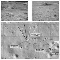
|
The view to the northwest has evening lighting, and must have been taken at the end of lunar day 3. The other image showing a crater on the inner wall of an older crater is probably pointing northeast as I show it with white lines, and if so it is taken with morning illumination on lunar day 4.
Phil
Posted by: Phil Stooke Apr 12 2019, 04:44 AM
This Weibo article:
https://www.weibo.com/ttarticle/p/show?id=2309404360195798102342
reports on the end of lunar day 4 - Yutu 2 just shut down - and includes an image of two craters. Total distance now 179 m, so only another 8 m after the noon break. That probably means more work on nearby rocks or other targets. The same article reports on Beresheet.
Phil
Posted by: Phil Stooke Apr 18 2019, 09:03 PM
No word yet on details of the 4th lunar day activities. I will save any map updates until I actually know something. However, the first data release from the radio astronomy experiment has done now, though only to the foreign partners, not to the public. Maybe other information will be coming soon (I am always an optimist).
Phil
Posted by: Phil Stooke Apr 27 2019, 12:09 PM
Yutu 2 should be just about waking up for Lunar Day 5. Andrew Jones has tweeted a newly released image:
https://twitter.com/AJ_FI/status/1122025757516226561
Which I have roughly reprojected:
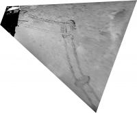
|
I am only guessing the orientation, where the pattern of tracks and the crater seem to match the last few drives on the most recently released route map from China (and the basis for my last update). If that is correct the image was taken with a fairly high sun a few days after sunrise on the 4th day, and the rover had not moved far at that point. It might have made a very small move or turned in place to put a target in view of its VNIS, but it has not moved far. But my guess might not be correct.
Phil
Posted by: Phil Stooke Apr 28 2019, 08:22 PM
Another tweet by Andrew Jones with 2 images:
https://twitter.com/AJ_FI/status/1122455703103389696
One image superficially resembles the previous one, but it's not the same place. Here it is projected in two different versions, but the orientation may not be correct. I should be able to figure out where this is but I'm not having any luck so far.
Phil
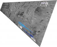
|
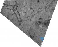
|
Posted by: Phil Stooke May 11 2019, 03:37 PM
http://news.sciencenet.cn/htmlnews/2019/5/426119.shtm
This Chinese science news site says the total drive after day 5 is 190.7 m.
Andrew Jones has tweeted two new images:
https://twitter.com/AJ_FI/status/1127074091767406592
New results are supposed to be published next week, so I hope there will be enough information to update the map.
EDIT: one of the new images tweeted by Andrew Jones shows tracks and, in the top right corner where the logo is inserted, a little cluster of rocks. I think they are the rocks examined early on day 3, the tracks were made later in day 3 and the image is from the morning of day 4, based on lighting. The tracks in the previous post are still not identified (by me at least).
Phil
Posted by: Paolo May 15 2019, 07:19 PM
That was quick... the first results from CE4 were published today in Nature:
https://www.nature.com/articles/s41586-019-1189-0
and an explanatory article:
https://www.nature.com/articles/d41586-019-01479-x
Posted by: Phil Stooke May 18 2019, 07:14 PM
This article:
https://media.weibo.cn/article?id=2309404372965893514367
includes this image:
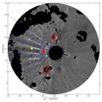
|
It shows a panorama projected into map form using a stereo topographic model to remove distortions - the black areas are hidden from the camera. A yellow dot is a science target, and red circles are craters to be avoided.
I have matched this with LRO images to confirm that it is from the end of lunar day 3, planning the science target work for day 4.
Phil
Posted by: Phil Stooke Jun 9 2019, 05:59 PM
As lunar day 6 nears its end, no specific news but I am hearing that Yutu 2 has exceeded 200 m total distance. Looking for confirmation.
Phil
Posted by: Phil Stooke Jun 10 2019, 06:51 PM
https://twitter.com/AJ_FI/status/1137933968584712192
Andrew Jones tweets about the end of day 6. 213 m total drive, 22 m in day 6. He tweets two pictures, and the one which shows a larger crater in the foreground is looking south-southwest (you can just see part of the rim at the very top of the image to help locate it). Knowing the direction we can see it has morning lighting, presumably from early in day 6. Here is a reprojected view:
|
That crater can be identified in the map, south of the 5th night location in my map.
Phil
Posted by: Phil Stooke Jun 10 2019, 07:08 PM
Looking roughly east, here is a composite of track images from the last few releases.
Phil
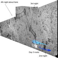
|
Posted by: Phil Stooke Jun 13 2019, 08:14 PM
Woohoo! (to coin a phrase). Check this out:
https://www.hou.usra.edu/meetings/planetdata2019/pdf/7030.pdf
An abstract for the Planetary Data meeting with a map of Yutu 2's path and other information.
Phil
Posted by: Phil Stooke Jun 13 2019, 10:59 PM
Meeting abstracts are here:
https://www.hou.usra.edu/meetings/planetdata2019/pdf/planetdata2019_program.htm#sess101
Phil
Posted by: Phil Stooke Jun 14 2019, 05:35 PM
This is the map from the abstract (hopefully considered 'fair use' for educational purposes). It is an excellent illustration of how the rover is driven, not with a 'joystick' controller and live (slow-frame) TV like the Lunokhods, but by mapping a safe route from end-of-drive images like the various Mars rovers. Sites are labelled, so I will be updating the route map soon.
Phil
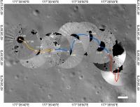
|
Posted by: John Moore Jun 20 2019, 02:23 PM
Below, an attempt to match the doughnut track positions to Phil's map. But don't take them as literal, as with most tracks, they all look the same, so open to correction (it all has to do with viewing/estimating the angles between each doughnut track - some approach angles under 90 degrees, others over 90, not to mention the paths taken, where some are straight-like, some curvable).
John
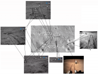
|
Posted by: Phil Stooke Jun 26 2019, 05:36 PM
That looks good, John.
Several new images were tweeted by Andrew Jones.
https://twitter.com/AJ_FI/status/1143769296973291521
Here I have reprojected them to make it easier for me to compare with a map, but so far I don't have good matches to locations for them. They suggest that the rover moved a bit to the west and then turned south during day 6 (so a map revision is needed), but I don't know enough to draw the route yet.
The article linked by Andrew says (according to Google Translate) that there were control problems during day 6 caused - apparently - by a single bit flip error on a chip. The Mars rovers have seen these occasionally and recovered. They are caused by cosmic ray strikes. Yutu 2 has been recovered successfully.
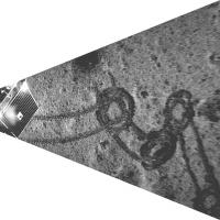
|
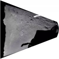
|
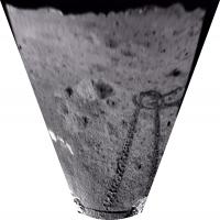
|
EDIT: I replaced the middle image with a different version. The orientation is changed, but please bear in mind that these Hazcam images have a wider field of view than I show here.
Posted by: John Moore Jun 27 2019, 10:56 AM
When I first saw the left-most image, Phil, I immediately thought 'Oh, that doesn't look good - some kind of surface-gripping struggle going on there.' But then thought that perhaps the rover was just doing more than one pivot on its axis as it planned its next route.
Btw, the doughnut images are probably wrong, as while the date they appear publicly are always out by several earth days to weeks, the actual lunar day date that they were taken is tricky to pin down (of course, CLEP, has that data).
John
Posted by: charborob Jul 2 2019, 03:06 PM
Two images of the lunar surface http://www.cnsa.gov.cn/n6759533/c6806675/content.html.
Posted by: Phil Stooke Jul 9 2019, 07:29 PM
Andrew Jones tweets two new images:
https://twitter.com/AJ_FI/status/1148511189216956416
They can be fitted together to make a mini-panorama:
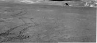
|
(here with some contrast enhancement).
And that can be roughly reprojected to give a more map-like view:
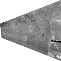
|
The lighting is around noon, so the rover may have travelled further since they were taken. No details on the distance travelled yet.
Phil
Posted by: Phil Stooke Jul 9 2019, 08:24 PM
That last view with the 6th night location shown.
Phil
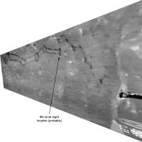
|
Posted by: Phil Stooke Jul 16 2019, 03:40 AM
A new paper on topo mapping of the landing site:
http://www.pmrslab.cn/publications/publications/isprs-archives-XLII-2-W13-1383-2019.pdf
Here is a very small panorama from it (I have cleaned up some glare in it):
|
|
and a circular version for mapping:
|
These are from the end of lunar day 1.
Phil
Posted by: Phil Stooke Jul 27 2019, 05:33 AM
This 'rover driving diary':
http://"%20<a%20href=" target="_blank">https://mp.weixin.qq.com/s/ULbPx6V957kW9CtR_cTU5g</a>
has some new images in it from day 7. Andrew Jones had tweeted some of them. The impression I have is that the rover did not move very far after its lunch break in day 7, so the estimate in my last map was overly optimistic. The drive was 25 m in day 7.
Here is a reprojected version of a mini-panorama from the link:
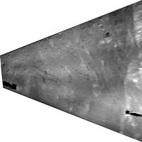
|
It is similar to the one I posted above but shows a little more progress, and the rover shadow at left shows it is taken with afternoon lighting.
There are also two sun-struck images, which can be fitted together like this:
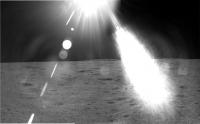
|
The view is to the northwest (showing the central peak) near sunset, presumably on day 7.
Phil
Posted by: Phil Stooke Jul 29 2019, 02:40 AM
Daniel Estevez has an analysis of the Longjiang 2 impact expected on 31 July:
https://destevez.net/2019/07/dslwp-b-mission-end-prediction/
It will crash near 15.5 north, 157.5 east, SE of Mare Moscoviense and about 300 km north of the Lunar Orbiter 1 impact site.
Phil
Posted by: John Moore Jul 29 2019, 12:23 PM
Looks like somewhere northeast of Van Gent T.
John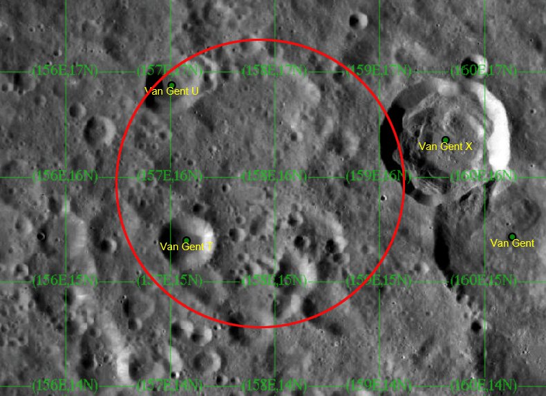
Posted by: charborob Jul 31 2019, 05:26 PM
Two images on the CNSA webpage, presumably taken on lunar day 8: http://www.cnsa.gov.cn/n6759533/c6807005/content.html
Posted by: Paolo Jul 31 2019, 06:37 PM
meanwhile, DSLWP-B has crashed on the moon, as expected
https://twitter.com/cgbassa/status/1156575266153648128
Posted by: Phil Stooke Jul 31 2019, 10:31 PM
A map of the impact area. The ellipse does not represent the formal uncertainty, it just indicates the approximate area and the direction of approach. I am assuming that Daniel Estevez's analysis did not take into account actual topography and just assumed a spherical Moon, so the along-track dispersion could be larger than this suggests.
Phil
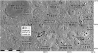
|
Posted by: Phil Stooke Aug 7 2019, 05:37 PM
https://twitter.com/AJ_FI/status/1159087623882903552
Andrew Jones tweets a drive distance of 33 m and a total of 271 m for day 8 (I have to work really hard not to write 'sol 8'). Two images are released, one showing tracks, the other taken with a high sun and showing bright crater rims. It looks southwest. The big crater with a few visible blocks might be the large sharp-rimmed crater shown in the latest route map, but I am not sure yet. If it is, most of the 33 m must have been driven early in the lunar day and only a bit after this was taken. I think. More information might overturn my speculations.
Here is the crater image in a rough perspective view:
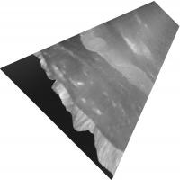
|
Phil
Posted by: Phil Stooke Aug 18 2019, 08:14 PM
A very detailed analysis of the Longjiang 2 impact location:
https://destevez.net/2019/08/trying-to-find-the-dslwp-b-crash-site/
Phil
Posted by: John Moore Aug 19 2019, 09:20 PM
Was close - initially posted on UMSF http://www.unmannedspaceflight.com/index.php?s=&showtopic=8057&view=findpost&p=245354
Below, an attempt of impact location according to Estevez's https://destevez.net/wp-content/uploads/2019/08/dem_map.png from https://destevez.net/2019/08/trying-to-find-the-dslwp-b-crash-site/.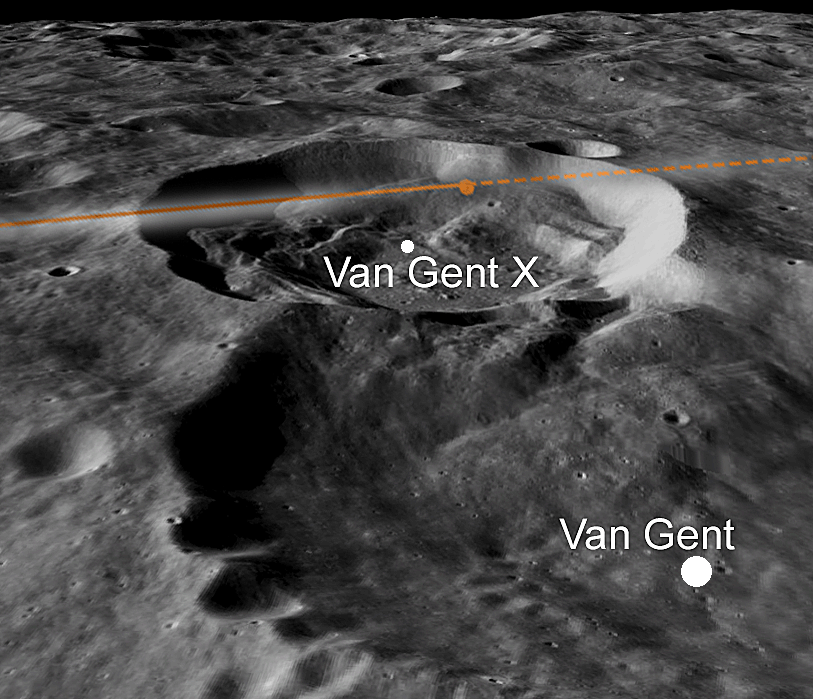
John
Posted by: Phil Stooke Aug 20 2019, 08:32 PM
There is a drive log for lunar day 8 https://mp.weixin.qq.com/s?__biz=MzU4MzQxMjI0OA==&mid=2247517450&idx=1&sn=e64fcb544a3e3aef64d3ef535795cfec&chksm=fdabba7dcadc336bdc666b1755c6a6c6319d109685b6969813bea8aecc429e9ca0809abc90da&mpshare=1&scene=1&srcid=&sharer_sharetime=1565993617652&sharer_shareid=e15413810aee17d969d78a7c9af0b426&key=e8b343f779d182b92e2220a706ea44d2f9f0f3453727638965f73bb82b76619b1e844b4c482eb28d81461e63aef51465d84088a2b31dfcff6a2b55dac0ad12388ca1a7d120b49a48bd60e9618f8e5653&ascene=1&uin=MTkyMjU0MzUyMA%3D%3D&devicetype=Windows+10&version=62060833&lang=zh_CN&pass_ticket=xUuzq7j8G34RkJ3%2Fz1f8GE8PxxsFXDQOBUR687hfsjdxSyzLALn1Y0o2%2BPTD3Mxe.
(That's a horrible URL, there must be a more direct way to link to the site).
Yutu 2 drove mostly to the west but turned off the path, probably to the southwest, to investigate a small very fresh crater which had an unusual object in or beside it. Sounds like a blob of impact glass. Then they backed up a bit, away from the crater.
I got this from here:
https://twitter.com/zengxingguo
Phil
Posted by: Phil Stooke Aug 23 2019, 09:23 PM
This is a composite of several images from the above driver's blog, reprojected very roughly to give a picture of the recent travels.
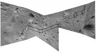
|
Phil
Posted by: Phil Stooke Aug 25 2019, 11:54 PM
There is a newly accepted paper in Geophysical Research Letters from Hu et al., on VNIS compositions at six sites over the first two lunar days. This builds on the paper on day 1 results which came out earlier. Bottom line is that the sampled materials are probably from the South Pole - Aitken basin impact melt sheet rather than basin ejecta.
Phil
Posted by: Explorer1 Aug 31 2019, 08:38 PM
A bit more detail on the small impact crater and the detour here: https://www.space.com/china-far-side-moon-rover-strange-substance.html
Might be impact glass, indeed!
Posted by: dudley Sep 2 2019, 03:08 PM
It seems very likely that the Chinese scientists would already know of natural glass, caused by meteorite impacts. Why, then, refer to this unidentified substance as 'gel-like'? They presumably had grounds for doing so. Moldavites and Libyan desert glass are usually green or yellow-green in color and not transparent. Perhaps this mysterious substance on the Moon was of some other color, or transparent, as gels often are.
Posted by: Explorer1 Sep 2 2019, 06:38 PM
My bet is something got lost in translation, rather than it being an actual gel as understood on earth.
Posted by: marsbug Sep 2 2019, 07:59 PM
In English 'gel' is something that is mostly liquid by weight, but behaves much like a solid due to a scaffold of long molecules runningthrough it... My memory of that definition may be off but my point it is that in English that word refers to a specific state of matter. Is it possible that, in Chinese, the word or phrase is more nubulously defined, or more descriptive of appearance than material state? I can imagine impact glass looks my gel like. I could also imagine a 'glass gel' of an impure glassy (by which I just mean non crystalline) material mixed with crystalline materials that might qualify as 'gel like' in another language, or specific context.
Posted by: dudley Sep 3 2019, 12:15 AM
The Chinese language appears to have distinct, specific words for both 'glass' and 'gel'--' boli' and 'ning jiao' respectively. They seem to mean the same, specific things that we do, when we use the words 'glass' and 'gel'.
Posted by: Phil Stooke Sep 3 2019, 02:36 AM
Nevertheless, this report is not from scientists but via a journalist or media outreach person working with the mission. Blobs of impact glass were seen by every Apollo mission and there is no other reasonable interpretation of this, as far as I am concerned. We may have to wait for a journal paper to know more, maybe in a few months.
Phil
Posted by: nprev Sep 3 2019, 10:35 PM
Agreed.
Furthermore, the difficulties of translation from Chinese dialects to English and vice versa are many, and that fact is rather well-known. Those become compounded if idiom is involved, or even many adjectives. But this case doesn't really seem that complicated. I can easily see how amorphous melt glass might be described as gel-like in appearance.
Bottom line is no, Chang'e-4 has not found jelly on the Moon.
Posted by: atomoid Sep 5 2019, 09:50 PM
We'll have to wait. For now im holding out hope for some https://www.reddit.com/r/forbiddensnacks/comments/7uwf4z/forbidden_moon_gummies/, even if https://www.candyindustry.com/articles/86890-moonpie-bites may be s'more fun 
Posted by: Phil Stooke Sep 14 2019, 06:40 PM
post 2287 on this forum page:
http://www.9ifly.cn/thread-5819-115-1.html
gives a summary of the mission including confirming what I had thought, that in May autonomous hazard detection and avoidance was tested on Yutu 2. It includes two images of a route map which I will se to update our map, when I can get to it (I'm on the road at the moment).
Phil
Posted by: Phil Stooke Sep 16 2019, 06:43 PM
Andrew Jones directed me to this drive diary for the 9th day:
https://mp.weixin.qq.com/s/NAm3JQHLJymMOofpGX4pHQ
It includes a mosaic which can be roughly reprojected to give this:
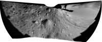
|
The day 9 tracks are at left. The diary describes efforts to analyze the odd material in the crater (open in Chrome for a rough translation).
Here I show an interpretation of the pattern of tracks. Not sure I have it right. The mosaic is from the end of day 9.
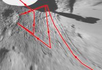
|
Map update will follow when I can get to it (I'm on vacation in Brittany)
Phil
Posted by: John Moore Sep 16 2019, 08:20 PM
I'll assume that the first image below is a track-image of where Yutu-2 pulled back (because of the first VNIS wasn't suitable), and then progressed forwards to conduct a second view as highlighted below in the second image (colouration is simply for clarification of the area concerned).
John

Also, I'm assuming, the highlighted sector (on left of the third image below) is relative to the sharp angles pronounced in Phil's image. 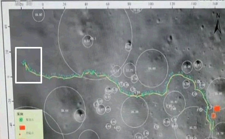
John
Posted by: Phil Stooke Oct 8 2019, 05:55 PM
https://www.weibo.com/ttarticle/p/show?id=2309404425030623690756
This link is to a rover diary for lunar day 10. Using Chrome to translate, it seems that some technical issues had to be overcome (sun sensor and knowledge of attitude) so not much movement this month - Andrew Jones tweeted that the drive was only about 5 m. Yutu 2 is still near the small crater with a bit of glass in it (and there's a photo of the sparkly glass in the article) and either made a new analysis with better lighting or is going to do that before they leave.
Phil
Posted by: Phil Stooke Oct 15 2019, 12:11 AM
https://twitter.com/AJ_FI/status/1183671036958642176
Here Andrew Jones tweets some more images from Yutu 2 including nice views of the central peak and the tracks behind the rover. I have projected those images (very roughly) to help with mapping.
Phil
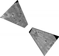
|
Posted by: Phil Stooke Oct 15 2019, 10:35 PM
That was a very crude reprojection of the tracks image for initial planning work. Here is a better version.
Phil
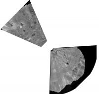
|
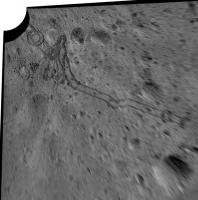
|
Posted by: atomoid Oct 25 2019, 08:41 PM
latest on the starch wreck gummies.. new https://www.space.com/china-far-side-moon-strange-substance.html has some processed images
Posted by: John Moore Nov 14 2019, 09:12 PM
Latest by LRO - finding the probable http://lroc.sese.asu.edu/posts/1132.
John Moore
Posted by: Phil Stooke Nov 14 2019, 09:46 PM
A very nice bit of work there by Cees Bassa, Daniel Estevez and others. This comparison of the before and after images shows the difference between the two frames, with increased contrast. The images were just taken from the release, obviously.
At first I thought the ejecta was deflected off the approach vector by the steep slope, but the difference image makes me feel it is more symmetrical.
Phil
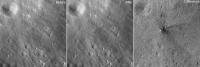
|
Posted by: John Moore Nov 14 2019, 10:32 PM
It truly is extraordinary from the LRO perspective -- given the very minute change in the terrain texture surface (barely noticeable by none of us, really).
John More
Posted by: Phil Stooke Nov 20 2019, 07:09 PM
There is a new drive diary for CE4's day 11 here:
https://mp.weixin.qq.com/s/XpmEyGIC9GmLWvB40L_CkA
(in Chinese). It includes links to past reports, which is really useful.
Here are versions of the images posted, processed to help make sense of the surroundings and tracks. Orientations are only approximate.
Thanks to Andrew Jones for drawing attention to this via a tweet. He also reports that Yutu 2 is just starting its 12th lunar day.
Phil
Before a tricky drive; after that drive, partial panorama late in the day (note faint tracks if you zoom in).
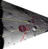
|
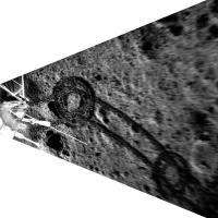
|
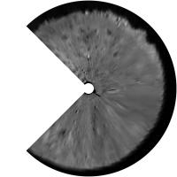
|
Posted by: zengxingguo Nov 21 2019, 02:45 PM
Great work Phil!
I am a Cartographer and a GISer working for NAOC, China. Our team are doing the data
preprocess and release for CE4 science data, according to the the data release policy of China
Lunar Exploration Program(CLEP), the CE4 science data will
be released in a year after the data are acquried, since CE4 started to get lunar image in Jan 3rd,2019;
so the first batch of CE4 science data will be released around Jan 3rd,2020.(http://moon.bao.ac.cn)
Hope it would be useful for you.
PS. We have planned to build a China Lunar and Planetary Data Node in 2020, Using PDS Standard,
then international cooperation are neccessary, and any suggestion or
questiones are warmly welcomed.
zengxingguo
zengxg@nao.cas.cn
https://mp.weixin.qq.com/s/XpmEyGIC9GmLWvB40L_CkA
(in Chinese). It includes links to past reports, which is really useful.
Here are versions of the images posted, processed to help make sense of the surroundings and tracks. Orientations are only approximate.
Thanks to Andrew Jones for drawing attention to this via a tweet. He also reports that Yutu 2 is just starting its 12th lunar day.
Phil
Before a tricky drive; after that drive, partial panorama late in the day (note faint tracks if you zoom in).
|
|
|
|
|
|
Posted by: Phil Stooke Nov 21 2019, 09:24 PM
Thanks for your very useful information. I had seen your tweet about the new data node, and it will be very exciting for all of us to see the released data. I will be especially interested in seeing assembled panoramas, on the multimedia site at http://moon.bao.ac.cn or in the archive. It has been very interesting to follow the mission even though our information is limited.
Phil
Posted by: Hungry4info Nov 25 2019, 10:11 PM
A lot of new, high-resolution Chang'e 4 images have now appeared on that website.
http://moon.bao.ac.cn/mul/index/list
Posted by: Phil Stooke Nov 25 2019, 11:56 PM
Yes! Something I had been waiting for. Click a thumbnail, and then click the larger version to get the full size. Here is a panorama made by the lander late in Day 1, in a circular projection to show a more map-like view of the landing site.
Phil
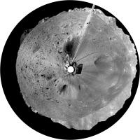
|
Posted by: Hungry4info Nov 28 2019, 08:23 PM
The Netherlands-China Low Frequency Explorer (NCLE) experiment has (partially) deployed its antennas. According to the commentary on https://phys.org/news/2019-11-dutch-chinese-radio-telescope-antennas-unfolded.html, Queqiao will function as a radio astronomy observatory during the lunar farside night.
However, they have had some difficulty deploying the antennas to full length.
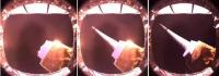
|
Posted by: Hungry4info Dec 12 2019, 09:37 PM
The latest released imagery (https://t.co/QKi3Z96Qnl?amp=1) appears to show this crater, though I'm not skilled enough to determine where this image was taken or if it represents a move toward that crater, however the text on the site appears to suggest that's the case. Translated with Google,

|
Posted by: Phil Stooke Dec 13 2019, 02:09 AM
I think it is that crater. Here is my interpretation of the new imaging, two views approximately identified, with a trace of the tracks from one of them. I used that to update the map.
Phil
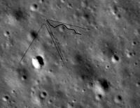
|
Posted by: Hungry4info Jan 3 2020, 10:26 PM
There has been a massive data release to the Chinese PDS at http://moon.bao.ac.cn, apparently comprising 38 Gb of data. I haven't quite figured out how to get to it myself, but there are some pointers in https://twitter.com/Yeqzids/status/1212995189498957824.
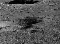
|
Posted by: djellison Jan 4 2020, 05:14 AM
WOAH....this is the first thing I could download and generate....just the first 6 images from the rover panoramic camera data.
Heads up - download the label AND the product.... and then open the label using the PDS4 viewer here : http://sbndev.astro.umd.edu/wiki/PDS4_Viewer
Straight up stitch, and debayered stitch attached.
(I'm dumping stuff here as I process it : https://dougellison.smugmug.com/Change-4-Yutu-2/i-SsB4MDr )
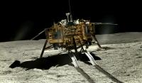
|
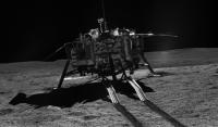
|
Posted by: Phil Stooke Jan 4 2020, 08:11 AM
Fantastic stuff, Doug. As is my wont, I had to make a circular projection of the 23 November panorama (after a bit of cosmetic work) (on the picture, not on me personally).
Phil
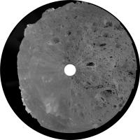
|
The crater with the glass in it is near the outer edge at 4 o'clock. I have roughly oriented it with north near the top.
Posted by: djellison Jan 4 2020, 10:51 AM
So this mosaic from July 29th 2019 is maybe the glass?
https://dougellison.smugmug.com/Change-4-Yutu-2/i-Dsn3GTd/A
I can see why it got their attention, but oh boy was that a case of lost in translation.
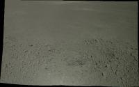
|
Posted by: djellison Jan 5 2020, 01:53 AM
Did a lot of processing last night - and tweeted out a thread on how to process the images as well
https://threadreaderapp.com/thread/1213326411370389504.html?refreshed=1578189033
This 6 frame mosaic from site 48 is probably my favorite.
https://dougellison.smugmug.com/Change-4-Yutu-2/i-hgFGNnh/A
Posted by: Phil Stooke Jan 5 2020, 07:34 AM
Doug has been tweeting site numbers, which are in the filenames along with the date. Here is a map with the site numbers I have seen so far. Please let me know if any more can be added, or if there is a map or table in the data release with this information.
Phil
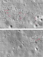
|
Posted by: Phil Stooke Jan 5 2020, 08:57 PM
Another of Doug's panoramas reprojected. This is the one from 28 February with severe sun glare in the east - taken soon after sunrise and showing the cluster of rocks which were the subject of the first VNIS analysis of a rock rather than regolith. I cleaned up some of the contrast variations.
Phil

|
Posted by: Phil Stooke Jan 8 2020, 07:10 PM
Doug posted another panorama, this time from Feb. 11th at site 10. It is exactly the same location as the image above, from the Feb. 28th panorama at site 11, but with evening lighting instead of morning.
Phil
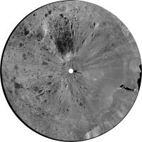
|
Posted by: Phil Stooke Jan 8 2020, 07:38 PM
... and Doug's new panorama from site 5, 31 January. This was very bland in the original so I have pulled out detail in the down-sun direction.
Phil
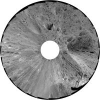
|
Also - this is the updated site numbers map. Maybe they should be called panorama numbers, if end of day and start of the next day panoramas at the same site have different numbers.
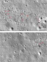
|
Posted by: djellison Jan 10 2020, 06:48 AM
Is there a gap in the panorama numbers that would be a helpful panorama, Phil?
Posted by: Phil Stooke Jan 10 2020, 07:30 AM
I would like to see anything around number 40, lunar day 6. The tracks there are complicated, it would be good to see them. But I'm happy with anything and everything!
Phil
Posted by: djellison Jan 11 2020, 06:05 AM
There are some gaps in the numbers....but here's what there was
Pan 38
https://dougellison.smugmug.com/Change-4-Yutu-2/i-4CGVmKJ/A
Pan 42
https://dougellison.smugmug.com/Change-4-Yutu-2/i-6V8tN8w/A
Pan 43
https://dougellison.smugmug.com/Change-4-Yutu-2/i-MTfQQVJ/A
Pan 47
https://dougellison.smugmug.com/Change-4-Yutu-2/i-Cx9z5NN/A (Pan)
https://dougellison.smugmug.com/Change-4-Yutu-2/i-9Bwk8mC/A (Polar)
Pan 92
https://dougellison.smugmug.com/Change-4-Yutu-2/i-ddLRMKL/A
Posted by: Phil Stooke Jan 11 2020, 07:21 AM
My hero!
Phil
Posted by: Phil Stooke Jan 12 2020, 01:38 AM
OK, to get started... this is a circular version (with considerable contrast enhancement) of the May 30 panorama. It shows how we can learn things from the images. The tracks show that this location is what I show on the map as the 6th lunar night stop. If Yutu 2 was there on May 30, it probably drove on May 27, 28, 29 and 30 and then stopped for its noon break. In the afternoon it did no driving and stayed there until waking for the next day.
EDIT: No... not quite. Now I have done the June 9 panorama, I see that the position on my map labelled June 9th was incorrect. So now I can see that there was a drive in the afternoon, and I can label the locations properly. I will update the map when I have all these things sorted out, but having the panoramas is very useful. Mapping like this is an iterative process.
Phil
|
Posted by: Phil Stooke Jan 12 2020, 07:41 PM
This is the updated map of panorama numbers. The base includes a correction for the end of lunar day 6. A full map update taking all panorama locations and dates into account will follow soon. Trying to map in real time is always going to be iterative!
Phil

|
Posted by: djellison Jan 12 2020, 08:19 PM
Yeah - the area around Pan 50 - the 'gel' crater - they certainly approach it a few times... https://dougellison.smugmug.com/Change-4-Yutu-2/i-H7Zxsqr/A
Posted by: Phil Stooke Jan 12 2020, 08:55 PM
One of Doug's panoramas in circular form.
Phil
July 6:
|
Posted by: Phil Stooke Jan 13 2020, 05:51 AM
This is the June 9th panorama reprojected.
Phil
|
Posted by: Phil Stooke Jan 13 2020, 06:21 AM
And here's a drive diary for the last lunar day. Open in something that will translate it for you.
Phil
https://www.bilibili.com/read/cv4340966
Posted by: Phil Stooke Jan 13 2020, 10:34 PM
This is the Oct. 25th panorama made by Doug and reprojected to show the area in a somewhat map-like form (but still full of topographic distortions) (are there DEMs in the data release?).
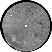
|
And an updated panorama number map. Doug says some numbers are missing. They may be other types of observation rather than panoramas.
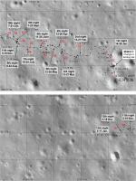
|
Phil
Posted by: djellison Jan 13 2020, 11:26 PM
I don't see DEMs in the release. I've tried some photogrammetry with the images with very very mixed results
Pan 10
https://sketchfab.com/3d-models/change-4-yutu-2-site10-d25b1b5ced5945df938c0f4cecab14ab
Pan 18
https://sketchfab.com/3d-models/change-4-yutu-2-site18-fe432bebb1c24ea1aa86461b3c3728bd
Pan 22
https://sketchfab.com/3d-models/change-4-yutu-2-site-22-174b8dcbd6a14cf3a578d458f0c84130
Posted by: Phil Stooke Jan 14 2020, 02:48 AM
Hi Doug - can you post the original Pan 18? I don't think it's on Smugmug yet.
Phil
Posted by: djellison Jan 14 2020, 04:45 AM
https://dougellison.smugmug.com/Change-4-Yutu-2/i-sbJvjxd/A
Posted by: Phil Stooke Jan 15 2020, 01:07 AM
Thanks so much. Here's a circular view.
Phil
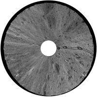
|
Posted by: Phil Stooke Jan 16 2020, 08:04 PM
Yutu 2 is just about to wake up for lunar day 14. This is a mosaic of two recently released images showing the road ahead towards a prominent crater (top left).
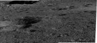
|
And a rough reprojection:
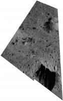
|
Phil
Posted by: Nordren Jan 19 2020, 08:14 PM
Lunar day 14 is underway. Yutu-2 rover awoke at 14:00 UTC January 18 and the lander following at 09:55 Sunday, according to a social media post from https://www.weibo.com/ttarticle/p/show?id=2309404462554129760548. Two images released.
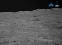
|
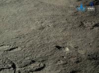
|
Posted by: djellison Jan 22 2020, 01:20 AM
So - I went thru every pan number there is for the rover, opened the label file for the first image listed and pulled out the start time, lat and long, and the X, Y, Z from the lander.
While other data sets do have some points at Pan numbers not listed below....they do not have the Lander frame X,Y,Z data
Zipped up XLSX attached, as well as a crude X vs Y scatter plot.
Pan Start Time Rover Longitude Rover Latitude Lander X Lander Y Lander Z
1 2019-01-04T04:15:18.011Z 177.599017 -45.44502 -1.759764 -12.692296 -0.834688
2 2019-01-10T21:11:29.451Z 177.598821 -45.444298 -5.91543 9.126358 -0.088721
3 2019-01-12T10:08:36.801Z 177.598632 -45.444101 -9.922689 15.07963 -0.429371
5 2019-01-31T17:25:22.255Z 177.598225 -45.443865 -18.552117 22.211425 -0.146258
6 2019-02-01T14:23:58.141Z 177.597694 -45.443521 -29.810781 32.606861 -0.249397
7 2019-02-08T20:45:47.117Z 177.59707 -45.443625 -43.041079 29.463715 -0.726265
9 2019-02-09T14:48:29.173Z 177.596713 -45.444048 -50.610007 16.680557 -0.230944
10 2019-02-11T02:59:33.023Z 177.596055 -45.443988 -64.561216 18.49327 -0.386951
11 2019-02-28T08:15:19.262Z 177.596055 -45.443988 -64.561216 18.49327 -0.386956
18 2019-03-03T07:24:14.968Z 177.595598 -45.444084 -74.250569 15.591778 -0.483145
19 2019-03-10T02:17:34.646Z 177.595597 -45.444073 -74.27177 15.924191 -0.830961
20 2019-03-10T15:11:37.602Z 177.595189 -45.444017 -82.922409 17.616099 -0.72672
21 2019-03-11T19:21:06.350Z 177.594663 -45.443716 -94.075368 26.711671 -0.401053
22 2019-03-12T07:54:14.510Z 177.594439 -45.443621 -98.824882 29.582277 -0.504348
30 2019-04-01T07:21:17.218Z 177.594177 -45.443472 -104.380201 34.084686 -0.722461
32 2019-04-11T02:06:15.518Z 177.593814 -45.443491 -112.076686 33.51002 -0.819108
33 2019-04-29T14:37:38.249Z 177.593636 -45.443368 -115.85098 37.226793 -1.013572
34 2019-05-01T03:04:12.505Z 177.593599 -45.443429 -116.63537 35.383341 -0.715814
35 2019-05-08T02:32:58.229Z 177.593603 -45.443427 -116.55055 35.443782 -0.925472
38 2019-05-10T10:01:15.233Z 177.593479 -45.443385 -119.179746 36.712826 -1.08647
42 2019-05-30T12:42:26.488Z 177.593088 -45.443538 -127.469635 32.088611 -0.784407
43 2019-06-09T02:41:56.276Z 177.592582 -45.443543 -138.198076 31.936669 -1.151678
44 2019-06-28T04:13:46.863Z 177.592056 -45.443531 -149.350636 32.298365 -1.162575
47 2019-07-06T11:30:53.779Z 177.591667 -45.443557 -157.598359 31.511912 -1.044718
48 2019-07-08T04:33:58.347Z 177.591486 -45.443507 -161.436147 33.022538 -1.172553
50 2019-07-29T01:18:59.329Z 177.590606 -45.443137 -180.095548 44.20197 -1.333302
53 2019-08-06T11:34:52.535Z 177.59065 -45.443311 -179.162096 38.943837 -1.152623
60 2019-08-27T09:42:41.591Z 177.590575 -45.443274 -180.75239 40.061796 -1.34759
67 2019-09-05T07:18:18.365Z 177.590437 -45.44312 -183.678869 44.715327 -1.204995
76 2019-09-25T03:18:38.935Z 177.590256 -45.443022 -187.516844 47.676434 -1.551671
92 2019-10-25T05:31:54.960Z 177.589671 -45.442755 -199.921397 55.7437 -1.410534
94 2019-11-03T01:21:53.512Z 177.589142 -45.442875 -211.137216 52.115973 -1.607826
95 2019-11-23T09:18:29.232Z 177.588667 -45.442573 -221.209778 61.241073 -1.127004
97 2019-12-02T05:21:08.786Z 177.588335 -45.442877 -228.247941 52.05335 -0.883405
I've also added a few more panoramas to the gallery including this one of Pan 0060 - probably the best of the 'gel' crater - https://dougellison.smugmug.com/Change-4-Yutu-2/i-ptMhv5d/A
Agisoft was able to extract a good model - https://sketchfab.com/3d-models/change-4-yutu-2-site-60-6771c8b961754cc5bf5679e069263852
|


Powered by Invision Power Board (http://www.invisionboard.com)
© Invision Power Services (http://www.invisionpower.com)