Printable Version of Topic
Click here to view this topic in its original format
Unmanned Spaceflight.com _ Perseverance- Mars 2020 Rover _ Jezero Delta Campaign, Sols 414-1000
Posted by: Julius Apr 21 2022, 07:21 PM
Think we can kick off the new phase of exploration at Jezero.
Posted by: Phil Stooke Apr 22 2022, 02:28 AM
Yes, I was thinking that. The new delta campaign has begun according to the press release.
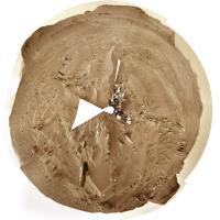
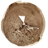
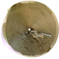
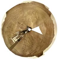
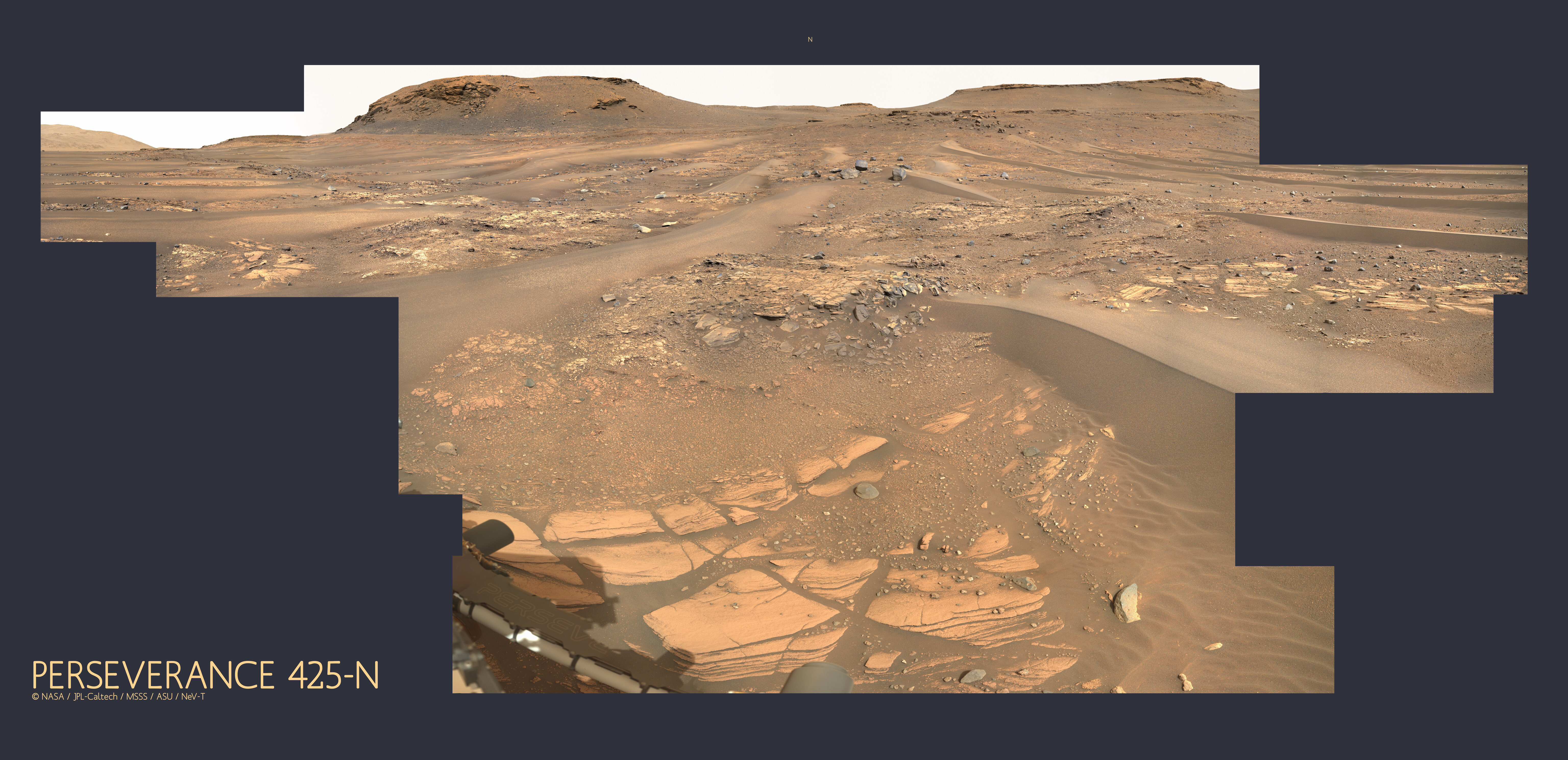
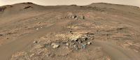
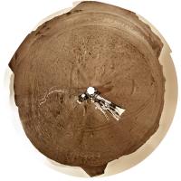
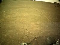
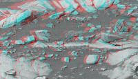
This is the sol 415 circular panorama showing us between the big drifts or ripples (aeolian bedforms), reminiscent of Opportunity many years ago. I haven't done the sol 414 version because I don't really want to deal with the multi-tile Navcams (4 tiles is bad enough, 16 is way too much for me to tackle with other work piling up). If someone makes a panorama for sol 414 I will use that to make a circular view.
Phil
|
Posted by: nprev Apr 22 2022, 08:20 AM
Topic title edited to include sol range- admin 
Posted by: PaulH51 Apr 22 2022, 01:04 PM
There's a NavCam thumbnail image of the sun from sol 416 with metadata that suggests there was a drive to site 23-1180 from site 23-0824. Looks like the images are late or they'll acquire them the following morning 
Posted by: tau Apr 22 2022, 05:01 PM
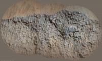
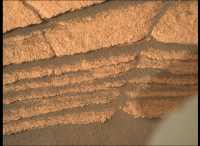
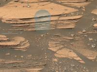
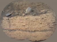
Sol 416 Supercam Remote Micro-Imager with Mastcam-Z and Navcam context
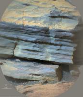
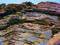
Finely laminated horizontal layering at the base of the hillside - are these the lake sediments we are looking for?
|
|

|
Posted by: Phil Stooke Apr 22 2022, 06:35 PM
Very nice images, Tau. I hope we can get to those outcrops.
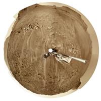
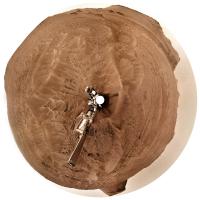
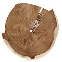
I changed my mind and made a sol 414 circular pan, using just the upper tier of the multi-tile Navcams to save time. Because of the projection I use the coverage even in just the upper tier is quite extensive.
These circular images don't need a special viewer. They are like a standard polar projection except that the radial scale is changed (roughly equivalent to a stereographic projection). The basic idea is that the middle part is like a map:

|
and the full image includes the horizon features all displayed at the correct azimuth. North is always at the top (or very near it):
|
Phil
Posted by: neo56 Apr 22 2022, 08:32 PM
End of sol 416 afternoon on Kodiak hill, taken with Navcam Left.
https://flic.kr/p/2ng3fYN
Posted by: Phil Stooke Apr 23 2022, 03:13 AM
Sol 416, lots of rocks here but the biggest drifts are behind us.
Phil
|
Posted by: Saturns Moon Titan Apr 23 2022, 08:39 AM
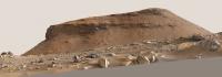
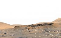
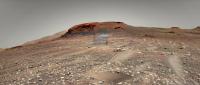
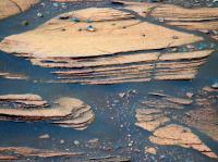
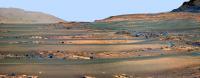
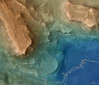
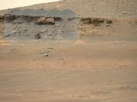
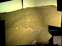
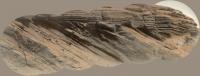
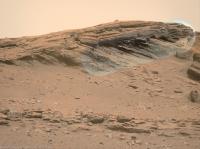
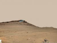
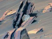
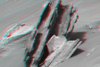
Remember that huge Mastcam-Z panorama from Sol 406? and at the left in the far distance there was an erosional surface preserved in the strata, but the image quality was quite poor? Well we now have our first high resolution view of that outcrop, taken on Sol 415. It shows the same tripartite system we've seen on Kodiak and elsewhere: inclined strata sandwiched between two horizontally bedded units.

|
Posted by: Toma B Apr 23 2022, 10:21 AM
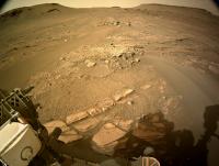
Kodiak Hill imaged by Mars Perseverances Mastcam-Z.camera on sol 416.
Just about 450 meters away from Kodiak hill. I think this is as close as we are going to see this feature ever.
https://flic.kr/p/2ngaZLAhttps://flic.kr/p/2ngaZLA by https://www.flickr.com/photos/tomabandin/, on Flickr
Posted by: tau Apr 23 2022, 12:04 PM
Yet another mosaic of Kodiak on sol 416, rotated to the horizontal
Interesting the multiple and partially opposed discordances in the upper center of the image
|
Posted by: serpens Apr 23 2022, 03:14 PM
Nice image Tau. There appears to be a transition in depositional environment from left to right with the distance between topsets and bottomsets narrowing with an apparent transition to a more energetic, turbulent flow. Unfortunately much of the transition point is obscured by detritus.
Posted by: StargazeInWonder Apr 23 2022, 04:35 PM
Perhaps this was noted in earlier threads, but when we see a feature like this stand so tall above the surrounding plains, but cover such a small part of the area, that means that locally the erosion of other delta material must have been absolutely massive, right? And likely the only agent capable of carrying so much material away would have been catastrophic flooding, right? So while we see, in the hill and more generally in the delta layers built up by one era of water flow, there must have been subsequent eras (or episodes) of water flow that tore a lot of that down in the direction from the remaining delta material towards the center of the crater. Does that sound right or am I missing some other possible agent of erosion? Wind, impacts, and seismic activity from Syrtis Major seem like other possible agents in the destruction of the delta's original edge, but for so much material to be carried away, it seems like water had to be a major player.
Posted by: Gladstoner Apr 23 2022, 05:36 PM
It's possible the thick cross-bedded unit in Kodiak butte was formed by eolian processes. Sand dunes and drifts likely formed across the delta during dry periods. The cross-beds seem to dip to the southwest (or somewhere between south and east), which would be unexpected with those formed by fluvial processes on the delta. Perhaps coastal dunes formed as the lake level dropped and sediment became available to wind transport.
As for Kodiak butte itself, it could be an old crater pedestal, where the rock altered by the impact became slightly more resistant than the surrounding material. Over time, the rest is eroded away by mass wasting and wind, leaving the neat little butte.
Posted by: djellison Apr 23 2022, 06:55 PM

Nope. Hundreds of millions of years and wind erosion are capable of this. See the best understood evolution of Gale Crater for similar massive volumes of wind erosion.
An incredibly slow mode of erosion, over incredibly long periods of time can literally vanish mountains.
Posted by: serpens Apr 24 2022, 03:16 AM
The maximum extent of the original deltas is not known but there are delta remnants similar to Kodiak some 3 km to the East of the current Neretva Vallis delta edge. Mars was probably a quite energetic environment when the lake dried out with reasonably rapid (in geological terms) erosion and step-back of the delta front. This occurred between the final drying out of the lake and the effusive lava that spread across the crater floor and embayed the delta and outlying remnants. As djellison indicates the environment now is most benign and any erosion is painfully slow.
Posted by: Ant103 Apr 24 2022, 01:51 PM
Sol 415 MastcamZ mosaic of that wonderful mesa :
https://db-prods.net/marsroversimages/Perseverance/2022/Sol415_Mastcam110.jpg
And the same Sol, Navcam full panoramic :
https://db-prods.net/marsroversimages/Perseverance/2022/Sol415_pano.jpg
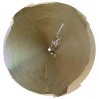
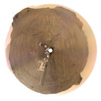
Posted by: Phil Stooke Apr 25 2022, 06:10 AM
Very nice, Damia. I couldn't resist making a circular version, hope you don't mind. This is without any extra processing. Later i will look at a higher contrast version.
We just had another drive on sol 418.
Phil
|
Posted by: Gladstoner Apr 25 2022, 06:27 PM
They have begun to image the light-colored beds at the base of Cape Nukshak:

|
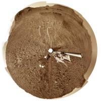
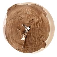
Posted by: Phil Stooke Apr 25 2022, 07:03 PM
The sol 418 panorama in circular form. Another drive on sol 419! - but not very long.
Phil
|
Posted by: Phil Stooke Apr 25 2022, 09:08 PM
Sol 419. Not sure if we are turning to examine something interesting, or to improve helicopter communications for a new flight (or those parachute images).
Phil
|
Posted by: Bill Harris Apr 25 2022, 09:44 PM
I presume that we've driven up on that Nukshak plateau.
Posted by: Julius Apr 25 2022, 10:03 PM
From the latest rover position it looks like Percy is still on the crater floor but probably plans to access the lower strata of the delta plateau from this location..easier access to avoid sand dunes perhaps?
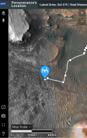
Posted by: Bill Harris Apr 26 2022, 02:24 AM
Sol 419 update of Rover's location (quick screengrab).
|
Posted by: Ant103 Apr 26 2022, 09:40 AM
Sol 419 Navcam panoramic. I just love here that feel of climbing up a hill.
https://db-prods.net/marsroversimages/Perseverance/2022/Sol419_pano.jpg
Posted by: Phil Stooke Apr 26 2022, 05:48 PM
That's a very nice panorama! Thanks, Damia.
This is sol 420's view in circular form. We moved about 60 m north to a rocky ledge.
Phil
|
Posted by: tau Apr 26 2022, 07:41 PM
1. Sol 419 Mastcam-Z left eye filters 1 to 6 multispectral principal components false colors
2. Navcam context
3. Mastcam-Z left eye filter 0 (RGB) raw image for comparison
1
|
|

|
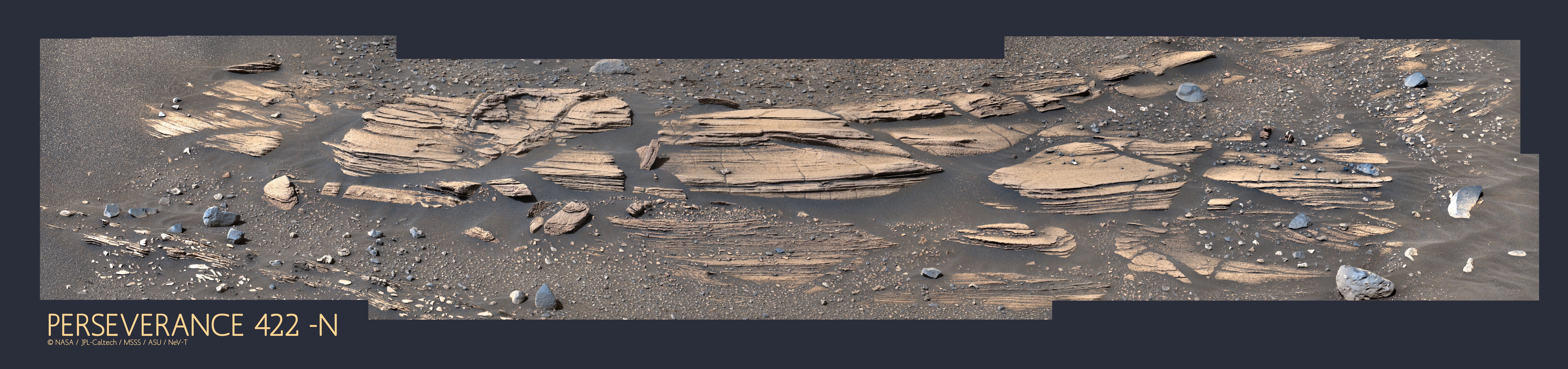
Posted by: neville thompson Apr 26 2022, 08:16 PM

Gigapan - http://www.gigapan.com/gigapans/229203
© NASA/JPL-Caltech/MSSS/ASU/NeV-T
Posted by: john_s Apr 26 2022, 10:07 PM
Spectacular! And welcome to the forum.
John
Posted by: neville thompson Apr 27 2022, 02:38 AM

Gigapan - http://www.gigapan.com/gigapans/229163
© NASA/JPL-Caltech/MSSS/ASU/NeV-T
Posted by: Ant103 Apr 27 2022, 09:03 AM
Thanks Phil
Sol 420 Navcam panoramic. I really love this place, it's nice to finally see changes in the landscape.
https://db-prods.net/marsroversimages/Perseverance/2022/Sol420_pano.jpg
Also deserved a Postcard :
https://www.db-prods.net/blog/2022/04/27/leaving-jezero/
Posted by: Saturns Moon Titan Apr 27 2022, 10:05 AM
© NASA/JPL-Caltech/MSSS/ASU/NeV-T
I think this portion of your panorama might be our best view of Neretva Vallis yet. Neretva Vallis is the canyon cutting through the crater wall of Jezero Crater about 7 km to the NW, through which the river that formed the Jezero delta flowed. Once the rover drives ontop of the delta, we'll finally get to see an unobstructed view of the canyon which we'll be driving through in a year or two.
|
Posted by: tau Apr 27 2022, 10:31 AM
Sol 420 Supercam Remote Micro-Imager mosaic with sol 419 Navcam context
The mosaic shows the upper right corner of the sol 419 Mastcam-Z multispectral photo (see post #27), but from a slightly different perspective.
|
|
Posted by: tau Apr 27 2022, 01:07 PM
Another sol 420 Supercam Remote Micro-Imager mosaic with sol 420 Mastcam-Z context
|
|
Posted by: Keltos Apr 27 2022, 01:09 PM
The mosaic shows the upper right corner of the sol 419 Mastcam-Z multispectral photo (see post #27), but from a slightly different perspective.
|
|
|
|
very nice view tau !
Distance: 310 m (rmi scale is 2.2 cm per pixel at 2000 m - source Dr. Gwénaël Caravaca)
Posted by: john_s Apr 27 2022, 01:38 PM
First closeup of the bedrock hereabouts. The texture looks like the Séítah rocks at first glance. But we may not have transitioned to the sub-delta layered unit yet.
John
Posted by: john_s Apr 27 2022, 05:23 PM
...aaand now we've transitioned to the layered unit:
|
Posted by: HSchirmer Apr 27 2022, 06:51 PM
Gigapan - http://www.gigapan.com/gigapans/229163
© NASA/JPL-Caltech/MSSS/ASU/NeV-T
Wow, amazing shot.
Definitely should be "Jakku lithofacies" due to the resemblance to fictional planet covered in crashed star destroyers...
Posted by: Phil Stooke Apr 28 2022, 03:34 AM
Sol 421, circular panorama with some nice outcrops between the aeolian ridges.
Phil
|
Posted by: Saturns Moon Titan Apr 28 2022, 08:57 AM
I concur with john_s. The rocks on Sol 420, best seen in Ant103's panorama, in my opinion look like the igneous rocks we saw earlier. Their colour, texture, and subdued relief reminds me of the upper Maaz formation members encountered early in the mission, remember the first failed coring attempt? Meanwhile the Sol 421 lithology is very different and is all consistent with prodelta mudstones, which must be an exciting moment for the mission's geologists.
That means sometime in the last drive, the rover crossed the geological contact between the two units. On the surface, this contact may not have been spotted, as the area is covered in sand ripples and the contact is between two quite soft rock types. However, perhaps they've detected the contact in the subsurface using Rimfax, the radar instrument. In fact, the last two drives look very well suited for doing such a radar survey: the rover pivoted northwards and has conducted a nearly straight, N-S transect across the boundary, so I expect that's what they're doing right now. The rover did this same thing the last time it crossed a major boundary, when it entered the Seitah Formation around Sol 200 (see image for the results of that survey). I wonder if this was a major motivation for the rover planners choosing to come here in the first place instead of going to Hawksbill Gap: because this area better preserves the contact between the delta and the lava flow, allowing them to do a transect & Rimfax survey.
|
Posted by: serpens Apr 28 2022, 12:41 PM
Given the step back of the delta and what appears to be a contact between the effusive lava and sedimentary deposits I feel the layered unit is more likely later delta deposits than prodelta/lake bed remnants. Getting close up and personal will tell the tale.
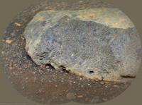
Posted by: tau Apr 28 2022, 12:56 PM
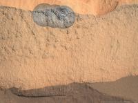
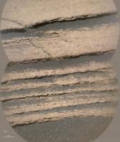
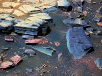
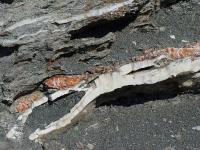
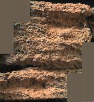
Layered outcrops at the base of Cape Nukshak.
1. Sol 420 Mastcam-Z image mosaic from a distance of about 44 m, with enhanced colors. I see two different layered units here: a bluish-gray unit on top of a orange-brown unit.
2. Sol 420 Mastcam-Z anaglyph
3. Sol 421 Navcam, now very close (about 5 m)
1
|
|
|
Posted by: Saturns Moon Titan Apr 28 2022, 08:32 PM
I agree, there's two distinct units here, corresponding to the different colours of the "bacon strip". I wonder what the significance of that colour difference is? This Mastcam zoom-in taken today shows cm or mm-scale layering. Perhaps that represents annual cyclicity. The grain size seems to be too fine to resolve individual grains, certainly it's finer-grained than the aeolian sediment ontop of it. I hope the rover does an abrasion here so we can see how thin the layering is & try and resolve some grains with the hand lens.
|
Posted by: PaulH51 Apr 28 2022, 09:42 PM
Sol 422 NavCam after a short bump
I have a feeling we could be here for a while
|
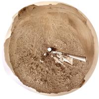
Posted by: Phil Stooke Apr 29 2022, 03:25 AM
Sol 422 circular view. As Paul says, just a small move.
Phil
|
Posted by: neo56 Apr 29 2022, 01:36 PM
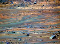
Peaceful sight of the rover's tracks winding across the floor of Jezero crater, imaged on sol 422 by Mastcam-Z Left.
https://flic.kr/p/2nhpKCA
Posted by: tau Apr 29 2022, 04:46 PM
Indeed, a very peaceful and beautiful picture. It looks like a romantic painting.
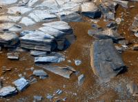
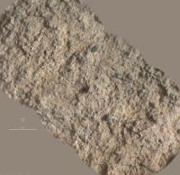
Layered outcrops at the base of Cape Nukshak, seen from a distance of about 6 m on sol 422
1. Supercam Remote Micro-Imager. A very rough grain-size estimate: in the rock about 0.4 to 0.5 mm, dark sand 0.2 to 0.3 mm
2. Mastcam-Z context
3. Mastcam-Z left eye filters 1 to 6 multispectral principal components
|
|
|
Posted by: tau Apr 29 2022, 07:58 PM
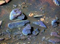
More layered outcrops at the base of Cape Nukshak in Mastcam-Z images from sol 423
1. Raw image filter 0 (RGB)
2. Left eye filters 1 to 6 multispectral principal components. A few stones have alternating blue/purple layers.
3. Right eye infrared filters 1 to 6 multispectral principal components 1 and 2
4. Anaglyph

|
|
|
|
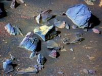
Posted by: Keltos Apr 30 2022, 08:19 AM
1. Raw image filter 0 (RGB)
2. Left eye filters 1 to 6 multispectral principal components. A few stones have alternating blue/purple layers.
3. Right eye infrared filters 1 to 6 multispectral principal components 1 and 2
4. Anaglyph
|
|
|
|
|
|
|
|
Tau : any clue as to what minerals the colors represent?
do we have mudstone here ? grain is not visible but the resolution lacks a bit it seems
Posted by: neville thompson Apr 30 2022, 03:09 PM

Gigapan - http://www.gigapan.com/gigapans/229244
© NASA/JPL-Caltech/MSSS/ASU/NeV-T
Posted by: neville thompson Apr 30 2022, 07:54 PM

Gigapan - http://www.gigapan.org/gigapans/229249
© NASA/JPL-Caltech/MSSS/ASU/NeV-T
Posted by: neo56 Apr 30 2022, 08:18 PM
Panorama taken with Navcam Left (my first attempt to this tricky dataset!) on sol 422 at 14:12 LMST.
https://flic.kr/p/2nhBQpZ
Posted by: tau Apr 30 2022, 08:40 PM
Sorry, no clue. The colors are somewhat arbitrary, because the results of the principal components analysis depent on the overall image content and some manual adjustments.
Irrespective of this, radiometrically calibrated multispectral image data are required for mineral determination.
An idea of the calibration and processing pipeline is given by https://link.springer.com/article/10.1007/s11214-021-00795-x, https://doi.org/10.1007/s11214-020-00774-8, and https://pds-imaging.jpl.nasa.gov/data/mars2020/mars2020_mastcamz_sci_calibrated/document/mastcamz_derived_product_sis_v1.3.pdf.
With radiometrically calibrated data and mineral spectra libraries, it might be possible, see the "Mineralogy" chapter and Fig. 3 in https://doi.org/10.1007/s11214-020-00755-x.
The rover has further instruments for elemental and mineral analysis (https://en.wikipedia.org/wiki/SuperCam, https://en.wikipedia.org/wiki/Scanning_Habitable_Environments_with_Raman_and_Luminescence_for_Organics_and_Chemicals).
Posted by: StargazeInWonder Apr 30 2022, 09:11 PM
I think with PCA, all that you can safely say about two highly contrasting colors is that there is a difference between two things, but there's no definite information about the nature of that difference, and it could easily be some combination of illumination, texture, composition or possibly other things, in any unknown combination.
For example, when you see the color patterns where oil or gasoline and water are on wet pavement, the color differences have absolutely nothing to do with compositional differences.
An image of snow and ice might show considerable variation in color even though every bit of solid present is pure H2O.
Moreover, with the PCA, the contrasts seen across one part of the image are further altered by what happens to be present in other parts of the image.
We may easily be looking at one more or less constant composition of the rocks in these photos with different history of weathering, burial, dust cover, etc.
Posted by: neville thompson Apr 30 2022, 09:19 PM
Gigapan - http://www.gigapan.org/gigapans/229250
© NASA/JPL-Caltech/MSSS/ASU/NeV-T
Posted by: Bill Harris Apr 30 2022, 10:34 PM
Very good, Tau. My sense suggests to me that the finely-bedded bluish rocks are silt- or mudstones. Fine particle sizes that remained in suspension and settled away from the early delta. The purplish rocks are a different mineralogy and are somtimes associated with the siltstone units, which may well.be cyclic. Some purplish rocks appear to be coarse grained and may represent rocks that have tumbled down from higher in the section, or may represent cataclysmic flows in the streams or may represent turbidites from the delta. The mineralogical difference may be the result of intense chemical weathering of volcanic rocks in wet basins of the upland that were breached during intense rainfall events and entered the streams as a slug.
--Bill
Posted by: serpens May 1 2022, 05:54 AM
If you are right that the deposition was fallout in the lake prior to delta formation Bill then couldn't the banded layers reflect variations in oxygenation conditions within the lake? Assuming an abiotic influence, say periodic changes in cloud or ash cover affecting levels of UV at the surface and potentially shallow water.
Posted by: tau May 1 2022, 09:47 AM
Moreover, with the PCA, the contrasts seen across one part of the image are further altered by what happens to be present in other parts of the image.
We may easily be looking at one more or less constant composition of the rocks in these photos with different history of weathering, burial, dust cover, etc.
Another example with relation to Mars:
A solid piece of crystalline hematite (like the famous https://en.wikipedia.org/wiki/Martian_spherules) is steel gray and may appear blue after PCA transformation.
Hematite powder is red (used as pigment Red ochre).
The nature of the difference here is the different particle size, the mineral is the same.
I hesitated to write it down until we get more details (high resolution images, mineral analyses).
Posted by: HSchirmer May 1 2022, 01:19 PM
Another example with relation to Mars:
A solid piece of crystalline hematite (like the famous https://en.wikipedia.org/wiki/Martian_spherules) is steel gray and may appear blue after PCA transformation.
Hematite powder is red (used as pigment Red ochre).
The nature of the difference here is the different particle size, the mineral is the same.
I had the same impression due to the smooth surfaces and thin layering.
I hesitated to write it down until we get more details (high resolution images, mineral analyses).
I'll mention again - might want to check the "Newark Basin Coring Project" out of Rutgers-
They were able to correlate orbital orientation to rainfall, correlated to lake depth, such that blueshales are deep-water anoxic,
redshales are shallow water-playa exposed and oxidized.
Some terrestrial basins have tell-tale enrichment of rare-earth elements from the deepest lakestands, I'd be quite curious to see if any of those compounds turn up, or are detectable.
Meanwhile- What's that? Everyone's looking at the silt layers, what's with the 'worm castings?"
|
Posted by: tau May 1 2022, 04:45 PM
A SuperCam image of this little pile would be interesting,
and a SuperCam image of the bumpy surface of this purple rock in the foreground of the sol 423 Mastcam-Z image below.
|
Posted by: tau May 1 2022, 04:49 PM
Here comes a sol 424 SuperCam RMI mosaic of the presumed siltstone/mudstone with sol 423 Mastcam-Z context.
The graininess in the bluish-gray parts of the SuperCam image is most likely image noise.
Possible mineral grains are too small to be visible. If there are grains, their diameter should be less than 0.15 mm assuming that at least 3 pixels are necessary to resolve a grain.
The vertical sequence of laser shots in the center of the SuperCam mosaic indicates that a chemical-mineralogical analysis is in progress.
|
|
Posted by: neville thompson May 1 2022, 07:48 PM
Gigapan - http://www.gigapan.com/gigapans/229259
© NASA/JPL-Caltech/MSSS/ASU/NeV-T
Posted by: Bill Harris May 1 2022, 09:26 PM
Meanwhile- What's that? Everyone's looking at the silt layers, what's with the 'worm castings?"
I'm not willing to stick my neck out on that just yet!! Aeolian weathering can create the strangest shapes!!
--Bill
Posted by: Bill Harris May 1 2022, 09:42 PM
Absolutely. In (polluted) terrestrial waters you can have low dissolved oxygen due to BOD (Biological Oxygen Demand) and COD (Chemical Oxygen Demand). The chemistry of the water can scavenge oxygen. And still water in the bottom of a basin or Cup (
 ) can certainly produce anoxic zones.
 --Bill
Posted by: tau May 2 2022, 09:54 AM
Sol 424 SuperCam RMI mosaic no. 2 with Mastcam-Z context and sol 422 Navcam context
|

|
|
Posted by: tau May 2 2022, 10:04 AM
Sol 425 SuperCam RMI mosaic with sol 423 Mastcam-Z context and sol 422 Navcam context
|
|
|
Posted by: HSchirmer May 2 2022, 11:29 AM
|
|
Interesting shapes- they remind me a bit of the raindrop casts you find in some eastern USA Triassic red shales.
Anyone heard any guesses on what size raindrops on Mars would grow to?
Posted by: AndyG May 2 2022, 11:57 AM
I know Ralph Lorenz has 'https://www.researchgate.net/publication/316312208_The_Changing_Nature_Of_Rainfall_During_The_Early_History_Of_Mars' on this matter!
In brief - it appears to depend on the atmospheric pressure.
Andy
Posted by: Phil Stooke May 2 2022, 07:09 PM
We have had some really nice panoramas posted by Damia and Thomas recently, certainly much better than I could manage. I have been playing with circular versions of them so here are some examples.
Damia, sol 419:
|
Thomas, sol 422:
|
and the same with some contrast enhancement and other processing:
|
And we just had another drive, this time to the east, looking like we will approach an interesting outcrop north of where we are now.
Phil
Posted by: Phil Stooke May 3 2022, 06:11 PM
Just reporting in from the MEPAG meeting. Ken Farley reports that the rover will now move back to the Three Forks area and up into Hawksbill Gap. It will survey outcrops on the way up, then sample them on the way down. At the end of 2022 it will be back at Three Forks and that may be the site of the first sample cache, because it is so flat and benign for operation of the later sample collection missions. Then Perseverance will climb onto the delta top for more sampling. It is possible that the cache will be closer to the crater Belva on the delta top, some time in 2023, but there is a desire to get a good cache safely deployed fairly soon. Later the rover moves to the main channel of the delta and finally up onto the crater rim in about 2024. A second cache would be further southwest after more sampling.
Phil
Posted by: Phil Stooke May 3 2022, 08:08 PM
This is Damia's panorama for sol 419 (as posted above) but with enhanced contrast and adjusted colour. Changing contrast messes up the colour, which is why I make changes to it. I know it's not realistic.
I have not worked on the latest panorama, hoping someone else will do it first.
Phil
|
Posted by: charborob May 4 2022, 02:23 AM
Sol 425 RMastcam-Z (34mm):
|
|
Posted by: Phil Stooke May 5 2022, 06:56 AM
sol 426, a circular panorama with lots of aeolian bedforms AKA drifty-like ripply-like objects.
Phil
|
Posted by: PaulH51 May 5 2022, 09:05 AM
More of those lovely aeolian bedforms (See Phil's post) this time after the drive on sol 428 (site 24-1970)
|
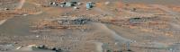
Posted by: Ant103 May 5 2022, 11:22 AM
Sol 428 Navcam panoramic. Look at this very nice place !
https://db-prods.net/marsroversimages/Perseverance/2022/Sol428_pano.jpg
Posted by: MarkL May 5 2022, 12:47 PM
The graininess in the bluish-gray parts of the SuperCam image is most likely image noise.
Possible mineral grains are too small to be visible. If there are grains, their diameter should be less than 0.15 mm assuming that at least 3 pixels are necessary to resolve a grain.
The vertical sequence of laser shots in the center of the SuperCam mosaic indicates that a chemical-mineralogical analysis is in progress.
|
|
|
|
Very interesting. Rather than strata these layers have the appearance of striations given the uniformity of the mineralogy and almost invisible grains and a colour which seems to match that of other igneous rock in the region. It seems very unlikely that distinct layers deposited in different periods would appear so uniform and cohesive with uniformly microscopic grain size and exhibit such stable fractures. Admittedly the orientation seems wrong but could be the result of a kinetic event. Glaciation or rock glaciation might explain the unusual erosion evident in the geography of the delta front.
Here's an example:
|
Posted by: tau May 5 2022, 01:29 PM
The mineralogy of many rocks here is most likely not homogeneous.
There are color variations (bluish/purple) parallel to the layers. They are particularly well visible in multispectral images like http://www.unmannedspaceflight.com/index.php?act=attach&type=post&id=50953 in post #48.
I would exclude a glacial influence on the shape of the rocks here.
Here come some more multispectral images. The next three were taken around SuperCam RMI investigations.
Sol 425 no. 1 Mastcam-Z left eye filter 0 raw image and filters 1 to 6 multispectral principal components

|
|
Posted by: tau May 5 2022, 01:31 PM
Sol 425 no. 2 Mastcam-Z left eye filter 0 raw image and filters 1 to 6 multispectral principal components
|
|
Posted by: tau May 5 2022, 01:33 PM
Sol 425 no. 3 Mastcam-Z left eye filter 0 raw image and filters 1 to 6 multispectral principal components

|
|
Posted by: tau May 5 2022, 01:34 PM
Sol 425 no. 4 Mastcam-Z left eye filters 1 to 6 multispectral principal components.
Links to filter 0 raw images: https://mars.nasa.gov/mars2020-raw-images/pub/ods/surface/sol/00425/ids/edr/browse/zcam/ZL0_0425_0704660028_988EBY_N0240000ZCAM03355_0340LMJ01.png and https://mars.nasa.gov/mars2020-raw-images/pub/ods/surface/sol/00425/ids/edr/browse/zcam/ZL0_0425_0704660240_988EBY_N0240000ZCAM03355_0340LMJ01.png part
|
Posted by: neville thompson May 5 2022, 06:39 PM

Gigapan - http://www.gigapan.org/gigapans/229280
© NASA/JPL-Caltech/MSSS/ASU/NeV-T
Posted by: Phil Stooke May 5 2022, 08:49 PM
Sol 427 panorama in circular form. I thought this area would be difficult to cross but it seems not. I only used the upper tier of tiles in the multi-tile image to save time.
Phil
|
Posted by: Phil Stooke May 5 2022, 09:15 PM
And this is Damia's very nice panorama from sol 428 in circular form, with a closeup of the area around the rover. Still lots of terrain relief distortion in this. Thanks for a timely panorama, Damia.
Phil
|

|
Posted by: neville thompson May 5 2022, 11:29 PM
Gigapan - http://www.gigapan.com/gigapans/229284
© NASA/JPL-Caltech/MSSS/ASU/NeV-T
Posted by: tau May 6 2022, 09:24 PM
Two SuperCam RMI mosaics from sol 428 with Navcam context image
|
|
|
Posted by: PaulH51 May 9 2022, 02:37 AM
A drive on Sol 432 takes the rover to site 24-2770
Trimmed this roughly assembled / processed end-of-drive tiled L-NavCam to remove a little image drop out.
JSON drive data not yet available.
|
Posted by: Phil Stooke May 9 2022, 07:42 AM
Now the map is updated - a good drive out of the ripple area and out into the plains of Three Forks. According to the MEPAG presentation we will head for the bacon buffet now.
Phil
Posted by: Bill Harris May 9 2022, 06:00 PM
Which map is updated, Phil? The last Route Map uodate ia 3May22.
Posted by: Phil Stooke May 9 2022, 07:31 PM
I was referring to the JPL map:
https://mars.nasa.gov/mars2020/mission/where-is-the-rover/
It is updated after every drive, usually within half a day.
Phil
Posted by: Gladstoner May 9 2022, 11:52 PM
Has Perseverance taken RIMFAX scans since it was at South Séítah? A scan around sol 419-422 could help determine whether the crater-floor volcanic unit onlaps or underlies the sedimentary beds of the delta.
Edit: Two possibilities:
|
Posted by: Phil Stooke May 10 2022, 02:39 AM
RIMFAX is used on almost every drive. A place as significant as this will certainly be probed by RIMFAX, but it may be quite a while before we get to hear about the results.
Phil
Posted by: tau May 11 2022, 12:36 PM
Sol 425 SuperCam Remote Micro-Imager mosaic with Mastcam-Z context and sol 422 Navcam context
Here is a http://www.unmannedspaceflight.com/index.php?act=attach&type=post&id=51004 to a multispectral image of the Mastcam-Z context
|
|
|
Posted by: Julius May 11 2022, 11:37 PM
Do we know what slope angles will Percy have to drive climbing up the delta?
Posted by: Phil Stooke May 12 2022, 07:12 AM
A circular panorama for sol 432, coming back into the Three Forks area.
Phil
|
Posted by: PaulH51 May 12 2022, 08:10 AM
After the short drive on Sol 434

|
Posted by: tau May 12 2022, 11:58 AM
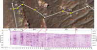
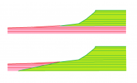
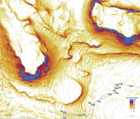
Here is a map of slope angles derived from a digital terrain model with a horizontal resolution of 1 m. Local small-scale slope angles may be greater than shown on the map.
Thick elevation contour lines every 10 m, thin lines every meter.
The steepest slope Curiosity has climbed so far in Gale crater was about 31 degrees to my knowledge, most probably on solid ground.
I wouldn't try this with Perseverance on a scree slope.
|
|
Posted by: MahFL May 12 2022, 05:59 PM
Don't forget Perseverance's wheels have twice as many treads as Curiosity's wheels, so that could mean less slippage when traversing slopes ?
Posted by: Phil Stooke May 12 2022, 08:44 PM
Sol 433 circular panorama. A good landing strip for the sample return lander!
Phil
|
Posted by: StargazeInWonder May 13 2022, 02:57 AM
Given tau's very nice topo map, it looks like Perseverance can reach some delta layers by climbing a slope no steeper than 6° in the direction of motion. That doesn't account for the need to negotiate some dunes in the early going, which is also tricky. But it looks like nothing harder than what Curiosity has already done.
Posted by: Phil Stooke May 13 2022, 03:45 AM
This is the description of future activities shown by Ken Farley at MEPAG (public information, will be online shortly). We are at point 4 now.
Phil

|
Posted by: Phil Stooke May 13 2022, 07:16 AM
The sol 434 panorama in circular form - I only had time to use the top tier of frames from the full resolution 4x4 Navcams.
Phil

|
Posted by: PaulH51 May 13 2022, 09:06 AM
A drive on sol 436 takes the rover closer to the bacon
Assembled in MS-ICE

|
Posted by: neville thompson May 13 2022, 03:27 PM

Gigapan - http://www.gigapan.org/gigapans/229339
© NASA/JPL-Caltech/MSSS/ASU/NeV-T
Posted by: neville thompson May 13 2022, 03:35 PM

Gigapan - http://www.gigapan.com/gigapans/229340
© NASA/JPL-Caltech/MSSS/ASU/NeV-T
Posted by: tau May 13 2022, 05:37 PM
Sol 436 Mastcam-Z with enhanced colors and anaglyph of a layered outcrop at Hawksbill Gap

|

|
Posted by: tau May 13 2022, 05:40 PM
Sol 436 SuperCam Remote Micro-Imager mosaic with Mastcam-Z context and sol 435 Navcam context.
The bright stripe at the lower edge of the SuperCam mosaic is part of the so-called "Bacon strip" at Hawksbill Gap.
|
|

|
Posted by: Keltos May 13 2022, 06:49 PM
The bright stripe at the lower edge of the SuperCam mosaic is part of the so-called "Bacon stripe" at Hawksbill Gap.
|
|
|
|
|
|
first one is a beaut Tau !!
Posted by: Phil Stooke May 13 2022, 09:31 PM
Circular view on sol 436, near the base of the slope.
Phil
|
Posted by: PaulH51 May 14 2022, 01:15 AM
Abother drive closer to the bacon on Sol 437

|
Posted by: Phil Stooke May 14 2022, 07:30 AM
Paul kindly let me use his assembled Navcams for a mosaic which let me produce this circular view for sol 437, saving me quite a bit of time. Thanks, Paul!
Phil
|
Posted by: tau May 14 2022, 05:59 PM
Sol 437 SuperCam Remote Micro-Imager mosaic with context by Mastcam-Z and Navcam
|
|

|
Posted by: PaulH51 May 16 2022, 06:52 AM
Another drive closer to the bacon: Sol 439

|

|
Posted by: Keltos May 16 2022, 08:55 AM
at the interface sol 439
stitched in photoshop and msice, location aprrox at end of blue line
|
Posted by: Phil Stooke May 16 2022, 05:49 PM
This circular view for sol 439 is compiled using Paul's Navcam images. Thanks, Paul!
Phil
|
Posted by: neville thompson May 16 2022, 07:08 PM

Gigapan - http://www.gigapan.com/gigapans/229361
© NASA/JPL-Caltech/MSSS/ASU/NeV-T
Posted by: PaulH51 May 18 2022, 07:59 AM
2 of the 5 end-of-drive 4-tile NavCams after the sol 441 drive to site 25/0000, map not yet updated, but it looks like a drive to the north (beyond the large ripples) and then westwards in the direction of Hawksbill Gap
I have assembled one further 4-tile NavCam, but the remaining end-of drive NavCam's currently have a number of missing tiles or suffer from some data drop out. Hopefully those issues will be addressed in the next downlink.
|

|
Posted by: Keltos May 18 2022, 12:07 PM
another 4 navcams of point a
layers are 3 per cleat space or 3.7 cm
|

|

|
Posted by: Phil Stooke May 18 2022, 08:31 PM
This circular panorama was compiled using Paul's Navcam images. Thanks, Paul! It wasn't easy to get them to fit together because quite a lot of the horizon is missing, but it worked in the end. Uphill a bit and then a left turn.
Phil
|
Posted by: tau May 19 2022, 12:05 PM
Sol 442 SuperCam Remote Micro-Imager mosaic with Navcam context
|
|
Posted by: tau May 20 2022, 05:44 PM
Sol 443 Mastcam-Z
1. Left eye raw image. A SuperCam RMI imaging of the bright stone in the center could be interesting.
2. Left eye filters 1 to 6 multispectral principal components. Five laser impacts are faintly visible on the yellowish slab.
3. Anaglyph
|
|
|
Posted by: Cherurbino May 21 2022, 04:09 AM
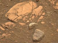
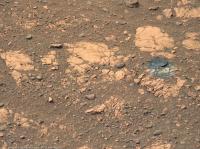
On Sol 441 one of the wheels uncovered the ocher/terracota-colored layer under the thin 'common dust' stratum and (crushed? / smashed? / smeared?) it. What substance can this layer consist of?
Link to the full-res NAVCAM_LEFT photo NLF_0441_0706100331_824ECM_N0250000NCAM03441_10_195J01 https://mars.nasa.gov/mars2020-raw-images/pub/ods/surface/sol/00441/ids/edr/browse/ncam/NLF_0441_0706100331_824ECM_N0250000NCAM03441_10_195J01.png.
Attachment: clipping from this photo in 4x magnification

|
Posted by: PaulH51 May 22 2022, 07:35 AM
This one took a long time to arrive, but it was worth the wait
end-of-drive NavCam from sol 443, roughly assembled / processed

|
Posted by: Phil Stooke May 22 2022, 08:44 PM
This is the sol 443 circular pan, constructed from the frames Paul kindly prepared.
Phil
|
Posted by: PaulH51 May 25 2022, 07:44 AM
Looks like a short drive to the West on Sol 448:
8-tile (4x2) mid-drive NavCam at site 25/0294 roughly assembled in MS-ICE

|
EDIT: I've editted the description as this was aquired during a pause mid-drive.
The drive continued further to the west, but the post drive images are incomplete at the time of this post
Posted by: Phil Stooke May 25 2022, 08:00 PM
This is from earlier in the mission but I didn't want to bury it in an old thread, so I hope you will forgive me for posting it here.
I have been going through the Analysts Notebook in PDS, collecting the uplink and downlink reports and trying to condense them into a reasonable narrative. This is for sols 1-178 only but more will follow.
It is not complete and needs editing - it still has some little notes to myself to look something up, and I am aware it is repetitive and not very exciting (it's not a novel, after all). But I post it here in case anyone finds it useful. It is just a plain text file.
Phil sols_edited.txt ( 54.29K )
: 226
sols_edited.txt ( 54.29K )
: 226
(PS you have no idea how time-consuming this is)
Posted by: PaulH51 May 25 2022, 09:56 PM
The drive on sol 448 had at least two stops for imaging. Here's one of the end-of-drive NavCams roughly merged with two later images that included a little more of the horizon that was missed due to the >10 degree roll of the rover, hopefully using those additional tiles might assist Phil to compile the polar view

|
Posted by: neville thompson May 25 2022, 10:31 PM

Gigapan - http://www.gigapan.org/gigapans/229423
© NASA/JPL-Caltech/MSSS/ASU/NeV-T
Posted by: Phil Stooke May 26 2022, 06:22 AM
This is the sol 448 panorama in circular form, made using Paul's Navcams. The addition of part of the horizon was very helpful.
Phil

|
Posted by: Keltos May 26 2022, 07:37 AM
Sol 449 mosaic of zcams and the scam closeup (center right of mosaic)
looks like a foamy structure again.. sandstone prob

|

|
Posted by: tau May 26 2022, 10:50 AM
Sol 449 SuperCam Remote Micro-Imager mosaic with Mastcam-Z context
|
|
Posted by: tau May 26 2022, 10:54 AM
Another sol 449 SuperCam Remote Micro-Imager mosaic with Navcam context

|

|
Posted by: Phil Stooke May 26 2022, 03:48 PM
https://www.science.org/doi/10.1126/sciadv.abn3783
Great new paper on dust devils and wind gusts in Jezero.
Phil
Posted by: PaulH51 May 27 2022, 02:28 AM
The L-NavCam workspace after a drive on Sol 449, resized to match the 4 tile versions from a 9-tile version
Roughly assembled in MS-ICE

|
Posted by: Phil Stooke May 27 2022, 06:57 AM
Well, that was a tricky one but I managed to put Paul's images together (he let me have a full set) - thanks, Paul. Here is the sol 449 circular panorama. It was a small move to put a tasty rock in the workspace.
Phil

|
Posted by: tau May 29 2022, 09:36 AM
Sol 450 SuperCam Remote Micro-Imager mosaic no. 1 with Navcam context

|

|
Posted by: tau May 29 2022, 09:38 AM
Sol 450 SuperCam Remote Micro-Imager mosaic no. 2 with Navcam context

|

|
Posted by: PaulH51 May 29 2022, 01:12 PM
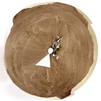
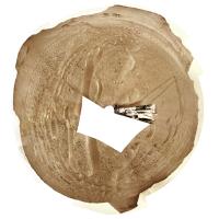
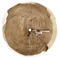
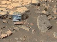
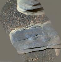
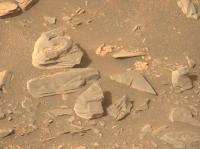
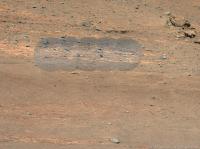
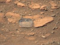
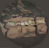
Sol 452 - Contact Science:
The first 1st abrasion of the delta campaign (Hazcam tile and SHERLOC WATSON)
I've rotated the S-WATSON frame to bring it closer to view from the other cameras on the rover
Both images have been cropped / processed

|
Posted by: Bill Harris May 29 2022, 04:07 PM
.dupe.
Posted by: Nahúm May 29 2022, 06:29 PM
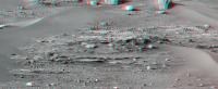
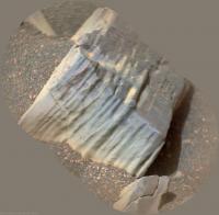
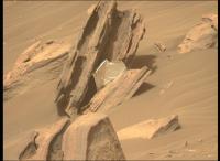
I think this is one of the most beautiful outcrops with a cross bedding seen by Perseverance.
This is a slice of the panorama taken on sol 451.

|
Posted by: StargazeInWonder May 29 2022, 07:37 PM
Looking at the horizontal layers in Post #136 (beautiful work, tau!) I wonder if this would mechanically allow a sample that grabs many layers in one tube, and imagine the science that could be performed on Earth, analyzing the differences from one layer to the next, potentially developing an account for how the local (planetary?) environment evolved from one specific martian year (?) to the next at some time in the remote past. It would be curiously specific in relative time, where we'd speak of Year Y, Y+1, etc., without ever knowing precisely when Y was.
This is incredible stuff in these pictures.
Posted by: Bill Harris May 29 2022, 07:41 PM
Tau, nice (apparent) grainsize distribution on these micro-images. They suggest higher stream load capacity and variability.
--Bill
Posted by: tau May 29 2022, 08:08 PM
The central part of the sol 451 Mastcam-Z panorama with enhanced colors

|
Posted by: tau May 30 2022, 03:23 PM
Sol 453 SuperCam Remote Micro-Imager mosaic with sol 449 Mastcam-Z context.
They were obviously taken from different waypoints, hence the distortion of the mosaic in the context image.

|

|
Posted by: tau May 30 2022, 04:37 PM
Meanwhile, sol 453 Mastcam-Z context images for the sol 453 SuperCam RMI mosaic in the previous post have arrived.
Here are left eye filter 0 RGB context with SuperCam inset, and multispectral filters 1 to 6 principal components.

|

|
Posted by: tau May 30 2022, 04:51 PM
Sol 453 Mastcam-Z image of the abrasion patch (with enhanced colors).
The surrounding area appears to be heavily disturbed by the abrasion process.

|
Posted by: tau May 31 2022, 12:00 PM
Even more colorful - the abrasion area in multispectral images
1. Mastcam-Z sol 453 left eye filter 0 (RGB) raw image for comparison (https://mars.nasa.gov/mars2020-raw-images/pub/ods/surface/sol/00453/ids/edr/browse/zcam/ZL0_0453_0707153419_081EBY_N0260000ZCAM03372_1100LMJ01.png to original image)
2. Left eye multispectral filters 1 to 6 principal components
3. Right eye infrared multispectral filters 1 to 6 principal components (unfortunately with strong filter flatfield inhomogeneities)
The pebble at pixel 190 from the left and 430 from the top looks unremarkably gray in image 2, but intensely blue in infrared image 3.

|

|

|
Posted by: charborob May 31 2022, 09:08 PM
Sol 454 LMastcam-Z:
|
|
Posted by: Phil Stooke May 31 2022, 11:16 PM
Earlier I posted a map showing potential routes into the delta from a presentation at the MEPAG meeting earlier this month. All presentations can be found here (linked from a PDF of the agenda):
https://www.lpi.usra.edu/mepag/meetings/mepag-39/Agenda.pdf
The Perseverance caching presentation by Farley is in the Tuesday session, top of page 2.
Phil
(PS - you're welcome, 65)
Posted by: PaulH51 Jun 1 2022, 02:19 PM
Sol 455: Drive to the north
4-tile NavCam roughly assembled in MS-ICE

|
Posted by: Phil Stooke Jun 1 2022, 08:32 PM
This is a circular view made from a full set of Paul's images from sol 455. Moving uphill. It's interesting that the rocky surface we are sitting on is so much less apparent from the surface than in the HiRISE images. Thanks, Paul, much appreciated.
Phil

|
Posted by: PaulH51 Jun 2 2022, 11:19 PM
Sol 456: Processed EOD 4-tile NavCam, roughly assembled in MS-ICE
|
Posted by: vjkane Jun 3 2022, 12:58 AM
Article on Nature on Perseverance's current campaign
https://www.nature.com/articles/d41586-022-01543-z
Posted by: neville thompson Jun 3 2022, 02:54 AM

Gigapan - http://www.gigapan.com/gigapans/229500
© NASA/JPL-Caltech/MSSS/ASU/NeV-T
Posted by: Phil Stooke Jun 3 2022, 06:51 AM
The sol 456 circular panorama made from Paul's Navcam composites. Thanks, Paul! Look at that tasty rasher of bacon!
Phil

|
Posted by: neville thompson Jun 3 2022, 10:59 PM

Gigapan - http://www.gigapan.org/gigapans/229506
© NASA/JPL-Caltech/MSSS/ASU/NeV-T
Posted by: climber Jun 4 2022, 08:04 AM
Whoa! I can see at least two places with reddish soil.
Your recent work on both rovers imagerys bring something different and very much appreciate Neville.
Posted by: neo56 Jun 4 2022, 08:50 AM
Panorama taken with Navcam Left on sol 456 at 15:20 LMST. Nice slice of bacon indeed Phil
https://flic.kr/p/2npNEmT
Posted by: PaulH51 Jun 6 2022, 01:42 PM
Close to the 'Bacon Strip' after a drive on Sol 460 (Site 26-470)
Attached are two of the end-of-drive 4-tile NavCam mosaics, giving us a wide view of the 'Strip'.
The mosaics were roughly assembled in MS-ICE

|

|
Posted by: Phil Stooke Jun 6 2022, 09:18 PM
Thanks to Paul's images, here is a circular view of the sol 460 panorama, almost at the bacon strip.
Phil

|
Posted by: Phil Stooke Jun 7 2022, 06:11 PM
Today, sol 461, we are on the bacon strip. More details later...
Phil
Posted by: neville thompson Jun 7 2022, 08:18 PM

Gigapan - http://www.gigapan.com/gigapans/229563
© NASA/JPL-Caltech/MSSS/ASU/NeV-T
Posted by: neville thompson Jun 7 2022, 10:54 PM

Gigapan - http://www.gigapan.org/gigapans/229564
© NASA/JPL-Caltech/MSSS/ASU/NeV-T
Posted by: PaulH51 Jun 7 2022, 11:20 PM
Phil
Not many post-drive NavCams frames available for processing yet, but here's the one that shows the rover on the 'Strip'
4-tile Sol 461 photomosaic roughly assembled in MS-ICE and de-greened in Photoscape (Site 26-630)
I've also added a drive data table extracted from the mission JSON files.

|

|
Posted by: serpens Jun 8 2022, 09:55 AM
Siltstone?
Posted by: tau Jun 8 2022, 07:25 PM
Sol 456 SuperCam Remote Micro-Imager mosaic no. 1 with Mastcam-Z and Navcam context
|
|
|
Posted by: tau Jun 8 2022, 07:27 PM
Sol 456 SuperCam Remote Micro-Imager mosaic no. 2 with Mastcam-Z and Navcam context
|
|
|
Posted by: tau Jun 8 2022, 07:30 PM
Sol 457 SuperCam Remote Micro-Imager mosaic with sol 459 Mastcam-Z and sol457 Navcam context

|

|

|
Posted by: tau Jun 8 2022, 07:36 PM
Sol 459 SuperCam Remote Micro-Imager mosaic with sol 459 Mastcam-Z and sol457 Navcam context

|

|

|
Posted by: Phil Stooke Jun 8 2022, 08:04 PM
Great images, Tau. Thanks!
And with some images from Paul and a bit of black magic, here is a circular view for sol 461. Bringing home the bacon!
Phil
|
Posted by: neville thompson Jun 8 2022, 09:20 PM

Gigapan - http://www.gigapan.com/gigapans/229574
© NASA/JPL-Caltech/MSSS/ASU/NeV-T
Posted by: tau Jun 9 2022, 11:58 AM
Sol 459 Mastcam-Z multispectral images of the context of the two SuperCam RMI mosaics in posts #167 and #168
1. Left eye filter 0 (RGB) raw image (https://mars.nasa.gov/mars2020-raw-images/pub/ods/surface/sol/00459/ids/edr/browse/zcam/ZL0_0459_0707691661_159EBY_N0260218ZCAM03376_1100LMJ01.png to original raw image)
2. Left eye filters 1 to 6 principal components
3. Right eye infrared filters 1 to 6 principal components (greenish to the right due to filter flatfield inhomogeneities)
4. Same as 3, enlarged, with the two SuperCam mosaics in the brightness channel for detail. Exact match not possible due to parallax between cameras.
1

|

|

|

|
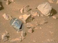
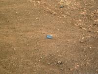
Posted by: tau Jun 9 2022, 03:02 PM
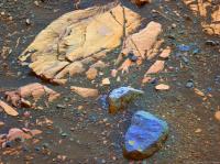
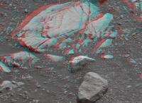
What's that? A piece of hardware lost during descent? A special and rare kind of rock?
1. Enlarged details of Mastcam-Z raw images
2. Mastcam-Z filter 0 RGB enhanced by principal components
3. Anaglyph

|

|

|
Links to original raw images: https://mars.nasa.gov/mars2020-raw-images/pub/ods/surface/sol/00461/ids/edr/browse/zcam/ZL0_0461_0707863568_428EBY_N0260470ZCAM08482_1100LMJ01.png https://mars.nasa.gov/mars2020-raw-images/pub/ods/surface/sol/00461/ids/edr/browse/zcam/ZR0_0461_0707863568_428EBY_N0260470ZCAM08482_1100LMJ01.png https://mars.nasa.gov/mars2020-raw-images/pub/ods/surface/sol/00461/ids/edr/browse/zcam/ZL0_0461_0707863594_428EBY_N0260470ZCAM08482_1100LMJ01.png https://mars.nasa.gov/mars2020-raw-images/pub/ods/surface/sol/00461/ids/edr/browse/zcam/ZR0_0461_0707863594_428EBY_N0260470ZCAM08482_1100LMJ01.png
Posted by: serpens Jun 10 2022, 07:06 AM
Nice Tau. At first sight the rock on the left looks like a contact between siltstone and sandstone deposits, possibly a deltaic upward coarsening succession. Where the silt would have deposited in relation to the delta front would depend in the difference in density between lake water and inflow. The bacon strip should raise a lot of questions/speculation.
Posted by: tau Jun 10 2022, 08:38 AM
Sol 462 SuperCam Remote Micro-Imager mosaic no. 1 with Navcam context

|

|
Posted by: tau Jun 10 2022, 08:42 AM
Sol 462 SuperCam Remote Micro-Imager mosaic no. 2 with 10 laser holes and Navcam context

|

|
Posted by: tau Jun 10 2022, 10:24 AM
Sol 463 SuperCam Remote Micro-Imager mosaic with 10 laser holes and Navcam context

|

|
Posted by: neville thompson Jun 10 2022, 07:50 PM

Gigapan - http://www.gigapan.com/gigapans/229610
© NASA/JPL-Caltech/MSSS/ASU/NeV-T
Posted by: neville thompson Jun 10 2022, 09:13 PM

Gigapan - http://www.gigapan.com/gigapans/229613
© NASA/JPL-Caltech/MSSS/ASU/NeV-T
Posted by: PaulH51 Jun 10 2022, 10:48 PM
A small selection of post drive L-NavCam tiled mosaics after a short drive on sol 464 to site 26/756.
All were roughly assembled in MS-ICE, & de-greened in PhotoScape

|

|

|
Posted by: Phil Stooke Jun 11 2022, 07:29 AM
Using a full set of Paul's images, here is a circular view of the sol 464 position.
Phil

|
Posted by: tau Jun 11 2022, 08:19 PM
Sol 464 Mastcam-Z
1. Left eye raw image
2. Left eye filters 1 to 6 multispectral principal components
Judging by the multispectral false colors, the conglomerate in the upper halfth of the image consists of a variety of different rock types an minerals.

|
|
Posted by: tau Jun 12 2022, 05:10 PM
Sol 464 SuperCam Remote Micro-Imager mosaic with Mastcam-Z context
|

|
Posted by: HSchirmer Jun 12 2022, 07:38 PM
Nice to be able to sample the rocks from an entire watershed, not just one site...
Posted by: tau Jun 12 2022, 08:22 PM
Sol 466 SuperCam Remote Micro-Imager mosaic with three laser holes (no context image available yet).
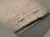
The SuperCam mosaic reminds me of veins of fibrous gypsum in claystone (see second photo) that I found just a few days ago on a small Gipskeuper formation hill in Thuringia.
It would be a nice coincidence if also Perseverance had found a vein of fibrous gypsum.
|
|
Posted by: charborob Jun 12 2022, 10:54 PM
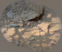
Interesting rock formations seen on sol 466:

|
Posted by: dburt Jun 13 2022, 04:10 PM
Virtually all the white Mars veins and veinlets probably consist of Ca-sulfates, but daily and seasonal temperature and humidity variations can cause apparent amorphization of surface sulfates (Ca-sulfates cycle among gypsum and the less hydrous forms bassanite and anhydrite). Therefore, nice fibrous gypsum crystals are unlikely at the surface. You might find them if you could dig.
dburt
Posted by: neo56 Jun 13 2022, 08:16 PM
Mastcam-Z Left mosaic made of 123 pictures taken on sol 466 (12 June, 2022) at 12:20 LMST.
http://www.gigapan.com/gigapans/229651
https://flic.kr/p/2nrQSRG
Posted by: PaulH51 Jun 14 2022, 11:08 AM
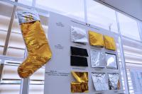
Looking suspiciously like a piece of EDL Hardware (FOD)
Sol 467 - L-MastCam-Z (full zoom)
|
Posted by: neo56 Jun 14 2022, 12:44 PM
Indeed, it really looks like a piece of multi-layer insulation. See this picture in the JPL shield shop from https://www.nasa.gov/image-feature/jpl/meet-a-spacecraft-dressmaker
|
Posted by: tau Jun 14 2022, 01:32 PM
Sol 467 Mastcam-Z left eye filter 0 (RGB) color-enhanced image and anaglyph
|
|
Edit Deleted size and distance values, have to check my calculations.
Does anybody know the exact distance between neighboring pinholes in the thermal blanket material?
Second edit Here are the results (without guarranty) of stereophotogrammetry again:
The distance from Mastcam-Z to the thermal blanket material is about 10.4 meter. The size of the visible part is about 21 cm.
The distance between neighboring small holes in the material is about 1.25 cm (about half an inch).
Posted by: tau Jun 14 2022, 05:00 PM
But much more interesting than the lost EDL hardware parts are the Martian rocks in a sol 467 Mastcam-Z image,
especially the one with the textured surface in the upper right part of the image.
Is the texture an effect of wind abrasion, or reflects it an internal property of the rock, or both?
Distance to the rock about 4.4 m, size about 2.6 cm (calculation results as usual without guarranty).
|
|
|
Posted by: neo56 Jun 14 2022, 07:28 PM
Just to share my calculations regarding the piece of (likely) thermal material that has been imaged: located at ~10.5m, it's 18cm x 10 cm.
Assuming a wind speed of 15 m/s (maximum measured by MEDA as far as I know), with a drag coefficient of 1.05 (cubic section, that's the closer I found), I compute a drag force of 0.044 N.
If the material is composed of Mylar (volumic mass = 1.38 g/cm^3), a layer of 6 µm has a weight of 0.00057 N.
So this drag force could lift a material composed of about 76 layers of Mylar.
Hence, it seems plausible that wind alone moved that thermal material.
Posted by: tau Jun 14 2022, 08:27 PM
Merci beaucoup, Thomas, for your calculations.
The difference between our independently determined distances to the object is about one percent, which is a very good agreement and dispels my doubts about my results.
The size of 21 cm I calculated is the largest diagonal of the piece, respectively the smallest diameter of a circle that contains the piece completely.
Posted by: PaulH51 Jun 14 2022, 08:48 PM
Did we get a context image of this target yet, just wondering of it's in the RA Workspace to try and get an idea of scale
Posted by: Cherurbino Jun 15 2022, 11:03 AM
out 1.25 cm (about half an inch).
See the https://www.sheldahl.com/sites/default/files/2020-02/RedBook.pdf of Sheldahl, p. 15 and further on

|
Posted by: HSchirmer Jun 15 2022, 11:39 AM
|
|
|
|
The distance from Mastcam-Z to the thermal blanket material is about 10.4 meter. The size of the visible part is about 21 cm.
Curious, it looks like there may be another fragment?

|
Posted by: Cherurbino Jun 15 2022, 11:54 AM
Attachment: a small smooth rolled pebble in 8× magnification.
Context: sol 467, ZL0_0467_0708387668_428EBY_N0260756ZCAM08487_1100LMJ01
442px from left, 43 px from the top of this original raw photo (including black margins)
https://mars.nasa.gov/mars2020-raw-images/pub/ods/surface/sol/00467/ids/edr/browse/zcam/ZL0_0467_0708387668_428EBY_N0260756ZCAM08487_1100LMJ01.png

|
Posted by: Cherurbino Jun 15 2022, 12:09 PM
If the material is composed of Mylar (volumic mass = 1.38 g/cm^3), a layer of 6 µm has a weight of 0.00057 N.
So this drag force could lift a material composed of about 76 layers of Mylar.
Hence, it seems plausible that wind alone moved that thermal material.
At this point it's a good reason to think about the non-zero probability of the event when next time the wind shall lift this piece of aluminium-covered material again and throw it on the rover. Especially onto the naked wires of the MEDA sensor.
Posted by: tau Jun 15 2022, 01:45 PM
Regarding the sol 466 SuperCam Remote Micro-Imager mosaic in this post:
Meanwhile we did, but it was the proverbial search for the needl in a haystack.
A Mastcam-Z stereo-pair of the vein was taken on sol 461 from an earlier waypoint.
The calculated distance to the stone with the vein was about 19 m on sol 461.
That gives a width of the entire http://www.unmannedspaceflight.com/index.php?act=attach&type=post&id=51250 of about 70 mm, and a thickness of the vein of about 4 to 7 mm.
The Supercam images of the vein were taken on sol 466 from a shorter distance (roughly estimated about 3 m).
Here are the context images:
1. Sol 461 Mastcam-Z, site 26 drive 470
2. Sol 464 Navcam, site 26 drive 694, blue dot above the image center
3. Sol 464 Navcam, site 26 drive 756
4. Sol 464 Navcam, site 26 drive 756 (3. and 4. same site and drive as the Supercam image)
1

|

|

|

|
Links to original raw images: https://mars.nasa.gov/mars2020-raw-images/pub/ods/surface/sol/00461/ids/edr/browse/zcam/ZL0_0461_0707862716_428EBY_N0260470ZCAM08482_1100LMJ01.png, https://mars.nasa.gov/mars2020-raw-images/pub/ods/surface/sol/00464/ids/edr/browse/ncam/NLF_0464_0708136209_896ECM_N0260694NCAM00301_01_295J01.png, https://mars.nasa.gov/mars2020-raw-images/pub/ods/surface/sol/00464/ids/edr/browse/ncam/NLF_0464_0708139709_055ECM_N0260756NCAM03464_07_195J01.png, https://mars.nasa.gov/mars2020-raw-images/pub/ods/surface/sol/00464/ids/edr/browse/ncam/NLF_0464_0708138841_380EBY_N0260756NCAM00708_07_0LLJ01.png
Posted by: tau Jun 15 2022, 05:37 PM
Regarding the perforation of the thermal blanket piece:
Thank you, Cherurbino, for your information.
I couldn't find a pattern in the book that matches well with the one on Mars.
Maybe, the imaged material does not have a standard perforation pattern, or it is from another provider,
or perspective shortening does not allow an exact calculation of the pattern on Mars.
Posted by: tdemko Jun 15 2022, 07:44 PM
especially the one with the textured surface in the upper right part of the image.
Martian beasties must have had three sets of chompers!
It looks like wind-enhanced differential weathering of cementation. Some minerals, especially carbonates, exhibit a cone-shaped pattern as the cement precipitates in the pore spaces of the rock or sediment. A least in this piece of float, it looks like there were at least three times in which the precipitation stopped and started, nucleating on the previous episode.
Check out these terrestrial examples:
https://ars.els-cdn.com/content/image/1-s2.0-S2095383615300523-gr3.jpg
https://ars.els-cdn.com/content/image/1-s2.0-S2095383615300523-gr9.jpg
from this paper:
https://www.sciencedirect.com/science/article/pii/S2095383615300523

|
Posted by: tau Jun 15 2022, 09:18 PM
And what's that?
Detail in a sol 467 Mastcam-Z image, enlarged and enhanced

|
Posted by: PaulH51 Jun 15 2022, 09:55 PM
Great images guys
Here's a new handy dandy info page that recently appeared on the https://mars.nasa.gov/mars2020/. Or you can access it directly on this https://mars.nasa.gov/mars-rock-samples/
It provides details on the cores and atmospheric samples acquired (so far) on the mission, some of the details are new (to me) including core length and rock type.

|
Posted by: Phil Stooke Jun 15 2022, 10:15 PM
Detail in a sol 467 Mastcam-Z image, enlarged and enhanced
Those are Shiitake mushrooms.
Phil
Posted by: tdemko Jun 16 2022, 12:51 AM
Although I love Phils answer, Im going to go with concretions. As with the previous cone/teeth structures, concretions and nodules are also cement phenomena. However, this time the pore fluid flow and geochemical gradients were such that the cement precipitated in spherical to mushroom shaped masses, rather than cones. Id attribute the flat tops to some kind of permeability boundary that prevented upward cementation past it.
I make the differentiation between concretions and nodules at obvious compositional banding or layering (concretion) and more or less uniform masses (nodules), although there can also be differences in whether the cement is pore-filling (concretions) or displacive (nodules).
The broken one shows some very obvious compositional banding, with a lighter internal band, possibly a sulfate mineral.
Posted by: nprev Jun 16 2022, 07:35 AM
ADMIN MODE: Seems like a good time to remind everyone, esp. our newer members, to carefully read the http://www.unmannedspaceflight.com/index.php?act=boardrules section with particular attention to rule 1.3.
Pareidolia is entertaining, but if it's given any credence whatsoever it's tin-hat time. We don't do that here. Period.
Thanks.
Posted by: Cherurbino Jun 16 2022, 09:45 AM
Thank you, Cherurbino, for your information.
I couldn't find a pattern in the book that matches well with the one on Mars.
And what about these two (p 16 and p.17, top)?
I doubt that NASA has other provider than Sheldahl for this stuff. Sheldahl has supported lots of projects for 20 years, including Mars-2020.
Perspective distortion is what matters most of all in this case.
You have chosen the right way to start with perforation holes: we know that they are ideal circles.
After that you calculated the diameter which found to be very close to the Sheldahl's standard which is 0.0450.
The last step is to choose between the patterns.It seems to me that there are only two to choose from: 045-0270 (page 16) and 045-0405 (page 17, top)
Source: the https://www.sheldahl.com/sites/default/files/2020-02/RedBook.pdf of Sheldahl.
Additional information: https://mashable.com/article/nasa-mars-rover-finds-debris-trash

|
Posted by: tau Jun 16 2022, 04:38 PM
I didn't calculate the diameter of the holes in the image because they are quite small, just about two pixels in diameter in the raw images (about 0.05 inch).
According to the http://www.unmannedspaceflight.com/index.php?act=attach&type=post&id=51257 we are looking almost perpendicularly at the sheet. Apparently it has a 60° staggered perforation pattern.
The distance between neighboring holes is about 1.25 cm (about 0.49 inch), calculated by stereophotogrammetry.
The most similar type in the catalog is 045-0405, but its distance between neighboring holes is 0.405 inch = 1.0287 cm, which is 18 % less.
When scaling the drawing in the book so that 1 inch of the drawing is equal to 1 inch on the piece on Mars, as in the image below, the patterns do not match.
Even scaling and projecting the other patterns in the book by looking at them at an angle (not perpendicularly), I haven't found one that fits.

|
Posted by: tau Jun 16 2022, 08:12 PM
Back from terrestrial material to Martian geology with a sol 467 Mastcam-Z anaglyph (enlarged).
The protruding thing (concretion?) at 1400 pixels from the left and 240 pixels from the top is 11 mm in diameter.
The smaller round ones on the rock in the center of the image are about 2 mm in diameter.
The distance from the camera was about 2.9 m.

|
Posted by: neville thompson Jun 17 2022, 07:55 AM

Gigapan - http://www.gigapan.com/gigapans/229703
© NASA/JPL-Caltech/MSSS/ASU/NeV-T
Posted by: neville thompson Jun 17 2022, 10:19 AM

Gigapan - http://www.gigapan.org/gigapans/229704
© NASA/JPL-Caltech/MSSS/ASU/NeV-T
Posted by: Keltos Jun 17 2022, 03:53 PM
1. Left eye raw image
2. Left eye filters 1 to 6 multispectral principal components
Judging by the multispectral false colors, the conglomerate in the upper halfth of the image consists of a variety of different rock types an minerals.
|
|
|
|
Can you tell me (i have photoshop) how you do that : turn the raw into those enhanced images that show different minerals / different colors ?
great work you do btw !!
here is a small ms ice panorama of the sol 470 watson images (laser stikes to the left)

|
Posted by: PaulH51 Jun 17 2022, 09:38 PM
The freshest abraded patch in Jezero (sol 471 SHERLOC-WATSON image)
Looks like the rock fractured during the abrasion process. I guess that may be considered a bonus as it shows the abraded surface and a freshly fractured surface, but maybe not perfect for PIXL?
A small light toned inclusion is also present.

|
Posted by: HSchirmer Jun 18 2022, 02:31 PM
Good point- I'm curious now, since the drill is an impact drill, perhaps future rovers would be able to split larger rocks using ancient technique of drilling a line of holes and then using a chisel to split the stone?
Would be interesting to see if it's possible to swap one of the spare drill bits for a splitting chisel and disable the 'rotate' function on the percussion drill to allow the rover to split rocks and reveal fresh faces.
A follow up thought- is the underside of these overhands also coated with dust? Curious whether the laser has been used to determine whether the underside of overhangs is also coated with dust? Question is whether the Martian dust has electrostatic properties which cause it to stick to all sides of the rocks, in contrast to simple 'air fall' where it coats the top surfaces?
Posted by: neo56 Jun 18 2022, 08:22 PM
My take on the WATSON mosaic of Bacon Strip, taken on sol 470 at 13:30 LMST.
Color corrected and correction of the artifacts due to dust on sensor.
It really reminds me the mudstones encountered by Curiosity at Pahrump Hills.
https://flic.kr/p/2nsQXjK
Posted by: tau Jun 19 2022, 04:07 PM
1. Sol 472 Supercam RMI mosaic with
2. Mastcam-Z left eye filter 0 context and
3. Mastcam-Z left eye multispectral filters 1 to 6 (visible to near infrared light) principal components image
1

|

|

|
Posted by: fredk Jun 19 2022, 06:30 PM
I get a distance to the sheet of around 10.6m (or 11.0m using the Bell etal toe-in angle rather than measuring it myself). That gives 1.36cm (or 1.42cm) for the neighbouring-hole separation (in the horizontal direction, which is closest to perpendicular to the line of sight). I don't know if this helps or not.
Looking carefully, there's some movement of the sheet between the two frames (so they can't've been exactly simultaneous) - that might affect these calculations a bit.
Posted by: tau Jun 20 2022, 02:35 PM
1. Sol 473 Supercam RMI mosaic of the abrasion patch
2. Sol 473 Supercam RMI mosaic in sol 472 Mastcam-Z left eye filter 0 context image
3. Sol 472 Mastcam-Z left eye multispectral filters 1 to 6 (visible to near infrared light) principal components
4. Sol 472 Mastcam-Z anaglyph
1

|

|

|

|
Posted by: Phil Stooke Jun 20 2022, 06:46 PM
Via Paul (who is helping me a lot lately) comes a name for the sol 471 abrasion patch: Elkwallow Gap.
Phil
Posted by: PaulH51 Jun 21 2022, 05:35 AM
Sol 474 Drive...
A selection of the post drive tiled NavCam's from site 26/0850 (roughly assembled in MS-ICE)
Looks like a nice layered target in the arm workspace

|

|

|
Posted by: tau Jun 21 2022, 06:23 PM
Sol 474 Mastcam-Z
1. Left eye raw image (without black frame)
2. Left eye multispectral filters 1 to 6 (visible to near infrared light) principal components
3. Anaglyph

|

|

|
Posted by: Saturns Moon Titan Jun 21 2022, 09:21 PM
1. Left eye raw image (without black frame)
2. Left eye multispectral filters 1 to 6 (visible to near infrared light) principal components
3. Anaglyph
Wow, the principle component colour composite really does an excellent job of picking out the layering in that rock.
Posted by: Phil Stooke Jun 21 2022, 09:40 PM
Paul's full set of images were used to make this circular view for sol 474 (I added one missing bit at the top of the hill).
Phil

|
Posted by: tau Jun 22 2022, 03:33 PM
A scenic Martian landscape with rover tracks in a small part of the sol 470 Mastcam-Z panorama looking south.
The horizontal ridge behind the nearest hill on the left is Séítah.
Around pixel coordinates 200 pixels from the left and 1575 from the top, the rover track of Sol 413 is clearly visible.
At pixel coordinates (520, 1610), the rover track of Sol 433 is very faintly visible.
What looks like a rover track at (100, 1500) is not a track, but a filled-in fracture with slightly raised edges.
Colors are enhanced.

|
Edit Corrected typo in sol number 470
Posted by: Bill Harris Jun 23 2022, 07:48 AM
This is a technique used since Spirit/Opportunity times to suggest compositional differences, although Tau has taken it to the next level.
--Bill
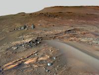
Posted by: neo56 Jun 23 2022, 09:20 AM
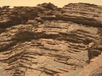
Panorama taken with Navcam Left on sol 474 at Hogwallow Flats, at 14:25 LMST. Really nice layered block near the rover. Does someone know if it has a name?
https://flic.kr/p/2ntJ12J
Speaking about that rock, I didn't have time yet to process the nice RMI mosaic taken on sol 436. Here it is, with the corresponding Mastcam-Z Left picture.
https://flic.kr/p/2ntQsMW
Posted by: tau Jun 23 2022, 01:08 PM
Sol 476 Sherloc Watson camera mosaic of this layered block near the rover.
Two blurred raw images at the top and bottom are not included.
|
Posted by: tau Jun 23 2022, 03:09 PM
Sol 476 SuperCam Remote Micro-Imager mosaic, most probably a detail of the layered block

|
Posted by: Phil Stooke Jun 23 2022, 08:57 PM
"Does someone know if it has a name?"
Paul sent me this link:
https://sketchfab.com/3d-models/m2020-zcam-bettys-rock-sol-467-2fa590899d254fb5b288c3ec9de27d4d
It is called Betty's Rock.
Phil
Posted by: PaulH51 Jun 24 2022, 03:24 PM
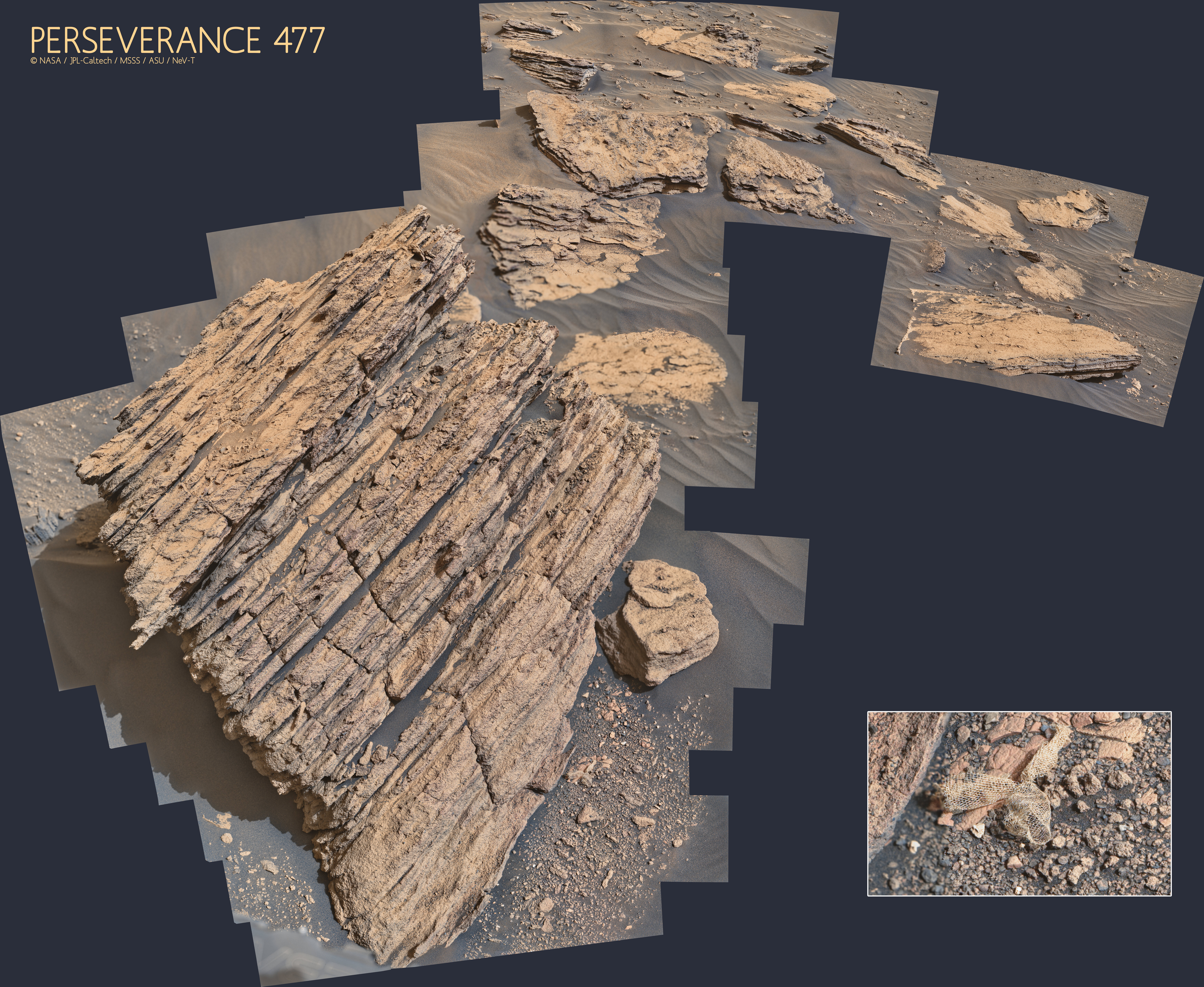
Sol 477 - A Short drive away from Betty's Rock:
A selection of 2x2 and 2x1 tiled NavCam photomosaics roughly assembled in MS-ICE

|

|

|

|

|
Posted by: Phil Stooke Jun 24 2022, 08:28 PM
Paul's images make this circular panorama for sol 477.
Phil

|
Posted by: Bill Harris Jun 26 2022, 04:08 AM
Two blurred raw images at the top and bottom are not included.
|
|
Fascinating distribution of angularity and of sorting.
Posted by: neville thompson Jun 26 2022, 01:38 PM

Gigapan - http://www.gigapan.com/gigapans/229771
© NASA/JPL-Caltech/MSSS/ASU/NeV-T
Posted by: tau Jun 26 2022, 04:04 PM
1. Sol 477 SuperCam Remote Micro-Imager mosaic, same detail of Betty's rock as the http://www.unmannedspaceflight.com/index.php?act=attach&type=post&id=51336, but with different sun illumination
― Sol 476: sun elevation 47°, sun azimuth 190°, light incidence almost perpendicular to the rock surface
― Sol 477: sun elevation 29°, sun azimuth 132°, longer shadows
2. Sol 477 SuperCam RMI mosaic in Mastcam-Z context
3. Sol 477 Mastcam-Z left eye multispectral filters 1 to 6 principal components
4. Sol 477 Mastcam-Z anaglyph
|
|
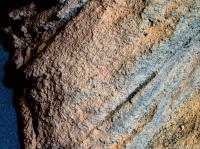
|
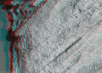
|
Posted by: tau Jun 26 2022, 04:10 PM
http://www.unmannedspaceflight.com/index.php?act=attach&type=post&id=51336 at the foot of Betty's rock in sol 474 Navcam context (same context for sol 477 mosaic)

|
Posted by: tau Jun 26 2022, 05:54 PM
Quite a soft piece of hardware on sol 477. Mastcam-Z right eye with enhanced colors.

|
Posted by: neville thompson Jun 26 2022, 08:57 PM
Gigapan - http://www.gigapan.org/gigapans/229773
© NASA/JPL-Caltech/MSSS/ASU/NeV-T
Posted by: neville thompson Jun 26 2022, 10:24 PM

Gigapan - http://www.gigapan.com/gigapans/229774
© NASA/JPL-Caltech/MSSS/ASU/NeV-T
Posted by: Cherurbino Jun 26 2022, 11:48 PM
One more artifact?
File details: ZR0_0477_0709275870_285EBY_N0260850ZCAM08498_1100LMJ Sol 477 09:48:27
2022-06-23 17:12:04.900
https://mars.nasa.gov/mars2020-raw-images/pub/ods/surface/sol/00477/ids/edr/browse/zcam/ZR0_0477_0709275870_285EBY_N0260850ZCAM08498_1100LMJ01.png

|
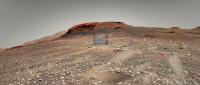
Posted by: PaulH51 Jun 27 2022, 07:30 AM
Having a closer look at 'Oventop Mountain'
Animated GIF: 5 HazCam frames from sol 480

|
Source for target name https://sketchfab.com/3d-models/m2020-zcam-oventop-mountain-sol-477-21ddf211a0a84c3f8d563a3d5f9cd4e3
Posted by: tau Jun 28 2022, 11:59 AM
"Betty's ribbon" on sol 477 with scale bar. The mesh size is about 2 mm.
1. Mastcam-Z right eye with scale. This piece of hardware wasn't there on sol 474, compare with this http://www.unmannedspaceflight.com/index.php?act=attach&type=post&id=51355.
2. Anaglyph as usual. If you have a display with only sRGB color space, you will see a strong ghosting of the right (cyan) image in the left (red filter) eye.
This is due to the highly unsaturated green sRGB display pixels with a significant amount of red in their spectrum.
3. To reduce this ghosting, I tried the following:
- Decreased the maximum green histogram value from 255 to about 100 or less.
- Decreased the maximum red histogram value from 255 to about 200.
The result is a darker image with quite a purple cast, but the stereoscopic effect on sRGB displays is improved.

|

|

|
Links to raw images: https://mars.nasa.gov/mars2020-raw-images/pub/ods/surface/sol/00477/ids/edr/browse/zcam/ZL0_0477_0709275870_285EBY_N0260850ZCAM08498_1100LMJ01.png, https://mars.nasa.gov/mars2020-raw-images/pub/ods/surface/sol/00477/ids/edr/browse/zcam/ZR0_0477_0709275870_285EBY_N0260850ZCAM08498_1100LMJ01.png
Posted by: Phil Stooke Jun 28 2022, 09:12 PM
Another name pops up: Skinner Ridge Rock.
https://mars.nasa.gov/mars2020/mission/status/388/sometimes-things-get-complicated/
Phil
Posted by: Bill Harris Jul 1 2022, 09:26 AM
Two blurred raw images at the top and bottom are not included.
|
|
Again, I am impressed with the sorting in this sediment view. It looks almost as if it was poured in. Is it a cataclysmic flow, such as a dam breaking? Or is it a turbidite from a collapsing delta front?
More clues from the outcrop!
--Bill
Posted by: neville thompson Jul 2 2022, 01:19 PM

Gigapan - http://www.gigapan.com/gigapans/229860
© NASA/JPL-Caltech/MSSS/ASU/NeV-T
Posted by: neville thompson Jul 2 2022, 09:49 PM

Gigapan - http://www.gigapan.com/gigapans/229871
© NASA/JPL-Caltech/MSSS/ASU/NeV-T
Gigapan - http://www.gigapan.com/gigapans/229869
© NASA/JPL-Caltech/MSSS/ASU/NeV-T
Posted by: neville thompson Jul 2 2022, 09:51 PM

Gigapan - http://www.gigapan.com/gigapans/229870
© NASA/JPL-Caltech/MSSS/ASU/NeV-T
Posted by: tau Jul 3 2022, 06:01 PM
The layered cliff of "Rocky Top" on sol 483
1. Mastcam-Z left eye filter 0 raw image, black frame removed
2. Mastcam-Z left eye, principal components of multispectral filters 1 to 6
3. Anaglyph
4. Navcam context
|
|
|

|
Posted by: charborob Jul 7 2022, 02:14 PM
Sol 489 LMastcam-Z:
|
|
Posted by: charborob Jul 7 2022, 02:40 PM
Sol 489 anaglyph:
|
|
Posted by: neville thompson Jul 7 2022, 04:43 PM

Gigapan - http://www.gigapan.com/gigapans/229911
© NASA/JPL-Caltech/MSSS/ASU/NeV-T
Posted by: Phil Stooke Jul 7 2022, 11:04 PM
https://mars.nasa.gov/mars2020-raw-images/pub/ods/surface/sol/00490/ids/edr/browse/ncam/NRF_0490_0710456117_926ECM_N0261004NCAM00709_01_095J02_800.jpg
A brand new sample on sol 490!
Phil
Posted by: neville thompson Jul 8 2022, 11:37 PM

Gigapan - http://www.gigapan.com/gigapans/229933
© NASA/JPL-Caltech/MSSS/ASU/NeV-T[size="5"][/size]
Posted by: neville thompson Jul 9 2022, 04:48 PM

Gigapan - http://www.gigapan.com/gigapans/229938
© NASA/JPL-Caltech/MSSS/ASU/NeV-T
Posted by: scalbers Jul 10 2022, 03:52 PM
Great display by Neville. Curious feature lurking if it's real.

|
Posted by: fredk Jul 10 2022, 06:46 PM
We're just seeing a gap between the rocks, as you can see from stereo views. Anaglyph:

|
Cross-eyed:

|
Posted by: tau Jul 10 2022, 07:34 PM
1. The sol 482 abrasion patch in a combination of enhanced colors from SHERLOC WATSON camera (sol 485) and higher-resolution details from SHERLOC ACI (sol 489).
2. The context of 1. in the SHERLOC WATSON camera raw image.
3. One of the SHERLOC Autofocus and Context Imager (ACI) raw images used for the focus stack.
Note: The faintly visible regular pattern of small circles is not a property of the Martian rock,
but presumably an effect of SHERLOC's ultraviolet laser used for Raman and fluorescence spectroscopy.

|

|

|
Posted by: scalbers Jul 10 2022, 08:45 PM
Yes indeed it is a gap, though I wonder about the bowling pin shaped feature within.
Posted by: mcaplinger Jul 10 2022, 09:51 PM
Isn't it just a rock on top of another rock?
Posted by: serpens Jul 11 2022, 05:32 AM
Or two small, adjacent rocks. Nice image though.
Posted by: scalbers Jul 11 2022, 05:02 PM
Yes would be interesting if it's possible to see the context of the rocks later on. The lighting regime is different from the foreground and one might guess where the more distant horizon is placed.
Posted by: PaulH51 Jul 11 2022, 11:36 PM
The 1st sedimentary core has been named 'Swift Run'
https://mars.nasa.gov/mars-rock-samples/

|
Posted by: Bill Harris Jul 12 2022, 01:17 AM
2. The context of 1. in the SHERLOC WATSON camera raw image.
3. One of the SHERLOC Autofocus and Context Imager (ACI) raw images used for the focus stack.
Note: The faintly visible regular pattern of small circles is not a property of the Martian rock,
but presumably an effect of SHERLOC's ultraviolet laser used for Raman and fluorescence spectroscopy.
1
|
|
|
|
|
|
And as seen in weathered outcrop, it has an unsorted, poured-in look.
Posted by: tau Jul 12 2022, 08:06 AM
Regarding the quoted post #256:
There seems to be a glitch in UMSF's content management system.
Originally I had the thumbnails and their numbers arranged in a horizontal row, and they were displayed that way after upload.
Now they are suddenly arranged in a vertical column, with a line break before each thumbnail, resulting in irritating numbering (see the quote in post #262 above).
Presumably this effect is triggered when a post is quoted.
This vertical arrangement of the thumbnails can be undone in the edit preview, but not in the uploaded post, so I removed the numbers in post #256.
Can anyone give a hint on how to avoid this effect?
Posted by: serpens Jul 12 2022, 01:18 PM
I'm a bit lost as to the depositional environment we are looking at with Oventop Mountain. I assume deltaic and poor sorting is common to foresets and bottom sets with slumps, sediment gravity flow and turbidity currents. But Oventop Mountain seems to lack any sizeable clasts, nothing more than sand and granules under the Wentworth scale. So I would hesitate to term it poorly sorted and posit it being the result of sorting with the delta slope fining downwards to pro delta.
Posted by: HSchirmer Jul 12 2022, 02:32 PM
Curious- having seen how some 'flashy' streams will dam the creeks they flow into, until the creek overtops the debris, and also seeing this in estuaries on Earth where sand dunes block a large slow estuary or river:
Could Martian dunes moving block and backup braided channels / estuaries with the eventual overtopping sluicing away well sorted sand as turbidity currents?
Posted by: PaulH51 Jul 13 2022, 02:08 AM
The second core has been extracted from the 'Skinner Ridge' rock seen in this NavCam tile from sol 495
Also what appears to be some EDL debris? captured in this HazCam tile from just in front of 'Skinner Ridge' on the same sol. Note: It was not in that location on sol 491.

|

|
Posted by: serpens Jul 13 2022, 06:15 AM
From your post #240 and link Paul, I thought this rock exposure was called Oventop Mountain?
Posted by: Phil Stooke Jul 13 2022, 07:55 AM
The previous name is the rock, the new name is for the sample. The second core will get another name.
Phil
Posted by: PaulH51 Jul 13 2022, 01:05 PM
It was referred to as Oventop mountain in one report, but looks like it may have changed, or someone slipped up.
Here is the JPL log of sample names, it does not include the latest sample yet, but you can see they now call the rock 'Skinner Ridge', the first core at Skinner Ridge was called 'Swift Run'
https://mars.nasa.gov/mars-rock-samples/

|
Posted by: fredk Jul 13 2022, 05:14 PM
In stereo - anaglyph:

|
Cross-eyed:

|
Give a hoot - don't pollute? Keep Mars tidy?
Posted by: PaulH51 Jul 13 2022, 11:17 PM
The second sedimentary core from 'Skinner Ridge' has been called 'Skyland' has been added to the mission samples page. A little shorter than 'Swift Run' at just 5.85cm

|
https://mars.nasa.gov/mars-rock-samples/
Posted by: Phil Stooke Jul 14 2022, 03:08 AM
Here are the names put on an image.
Phil

|
Posted by: tau Jul 14 2022, 08:18 PM
Sol 497 SuperCam Remote Micro-Imager mosaic with Mastcam-Z context and anaglyph

|

|

|
Posted by: tau Jul 15 2022, 09:16 AM
Sol 497 SuperCam Remote Micro-Imager mosaic no. 2 with sol 492 Mastcam-Z context
and sol 489 Mastcam-Z left eye multispectral filters 1 to 6 principal components
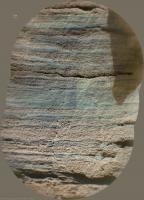
|
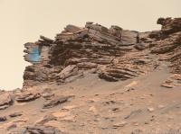
|
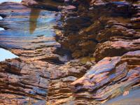
|
Posted by: PaulH51 Jul 16 2022, 03:26 AM
Apologies...
Posted to wrong thread.
Admin please remove post
TIA
Posted by: Phil Stooke Jul 16 2022, 07:52 AM
oops! Wrong rover...
Phil
Posted by: HSchirmer Jul 16 2022, 11:53 AM

|
Credit to Fredk for his Bayer reconstructed frames
Meh, better described as Hersey kiss on a brownie.
Posted by: Bill Harris Jul 16 2022, 05:16 PM
So much for the S:N ratio.
Posted by: Phil Stooke Jul 16 2022, 08:34 PM
I recently posted an image showing the abrasion and drill holes at Skinner Ridge, and it seemed like a good idea to do this for other sampling sites as well. This is the previous sample site at Sid:

|
For some reason the second drill hole at Atsah was not documented in images before we drove away.
Phil
Posted by: tdemko Jul 16 2022, 10:14 PM
and sol 489 Mastcam-Z left eye multispectral filters 1 to 6 principal components
I love this view because we see lamination-scale sedimentary structures very well. Although this view shows seemingly boring, horizontal centimeter-scale units, the close (zoom in!) view gives some important details:
1) the structure is visible due to differential weathering on a fracture (probably a joint formed during exhumation), probably controlled by varied degrees of cementation
2) the centimeter-scale units seem to be fining- and better-sorted-upward, probably graded, couplets
3) although dominantly horizontal and planar parallel, the finer tops of some of the couplets are capped by an erosion surface about half of a couplet in amplitude (this is how we can say which is the top or bottom of the couplet), and they are distinctly wavey in profile
4) there is an overall fining-upward trend in the view
My interpretation would be that this is the deposit of a single, waning, but pulsing, sediment-gravity flow. The couplets are a record of the passage and aggradation of individual traction carpets, with bypass and erosion between. This facies is not inconsistent with deposition on a the outer mouth bar or front of a delta. The traction carpets could have been part of an expanding sheet-like flow, or associated with larger bedforms like antidunes or cyclic steps.
Not sure if this helps or hurts the S:N, Bill!
Posted by: Bill Harris Jul 17 2022, 12:59 AM
Tim, it helps the S:N !
Posted by: PaulH51 Jul 18 2022, 11:11 PM
Drive during Sol 501: 19.4m ~Southwest, but still on the Bacon strip.
2x2 tiled NavCam and extracts from the JSON data.

|

|
Posted by: Phil Stooke Jul 20 2022, 05:55 PM
Here is a circular view of the sol 501 position from a full set of Paul's images. There is another small move on sol 502.
Phil

|
Posted by: vikingmars Jul 21 2022, 02:46 PM
Another small debris spotted Sol 484, while building a panoramic picture.
It has a more 'bluish' color when compared to other small rocks nearby.
Enjoy
Processed picture:

|
Weblink to the raw image:
https://mars.nasa.gov/mars2020/multimedia/raw-images/ZL0_0484_0709906568_098EBY_N0261004ZCAM08513_0340LMJ
Posted by: PaulH51 Jul 21 2022, 09:30 PM
Sol 504: The latest 5cm dia. abrasion patch on Mars.
Located on a rock called 'Wildcat Ridge' in the Hogwallow Flats area.
This time the fine-grained rocks of the Bacon Strip have not fragmented during abrasion.
Looks like there maybe be an existing fracture and what looks like a light toned fracture fill (more fun for the science team)
Source for the rock name: https://sketchfab.com/3d-models/m2020-zcam-wildcat-ridge-sol-502-aa7a278ba53e428ca8f7103eff79987a

|

|
Posted by: Phil Stooke Jul 22 2022, 03:39 AM
This circular view of the current location was made from Paul's sol 502 images.
The full panorama contains five full Navcam frames, pointing low, and 3 or (in this case) 4 partial frames extending it up to the horizon. Combining them is time-consuming (even with Paul's much appreciated help making the composites from smaller tiles). The whole process would be easier if the five frame pan was aimed high to get the horizon and the bottom was filled in with partial frames (covering mainly the workspace). I suppose there is a reason for doing it the other way - better stereo of the workspace, most likely.
Phil

|
Posted by: charborob Jul 25 2022, 06:29 PM
Sol 507 LMastcam-Z:

|
Another view on sol 507 (LMastcam-Z):
|
|
Posted by: tau Jul 25 2022, 07:40 PM
1. The sol 504 abrasion patch in a combination of enhanced colors from SHERLOC WATSON camera (sol 504) and higher-resolution details from SHERLOC ACI (sol 505).
The largest grain size is about 120 µm (light grains). The diameters of small grains are hardly discernible, but they are definitely smaller than 40 µm. Black dots are presumably pores.
2. The context of 1. in the SHERLOC WATSON camera raw image.
3. A wider context in a sol 504 Navcam image

|

|

|
Links to raw images:
https://mars.nasa.gov/mars2020-raw-images/pub/ods/surface/sol/00505/ids/edr/browse/shrlc/SC3_0505_0711798017_585ECM_N0261222SRLC11420_0000LMJ01.png (one out of five images)
https://mars.nasa.gov/mars2020-raw-images/pub/ods/surface/sol/00504/ids/edr/browse/shrlc/SI1_0504_0711684070_949ECM_N0261222SRLC08038_000065J01.png
https://mars.nasa.gov/mars2020-raw-images/pub/ods/surface/sol/00504/ids/edr/browse/ncam/NLF_0504_0711684404_926ECM_N0261222NCAM00709_01_095J01.png
Posted by: tau Jul 25 2022, 07:55 PM
Sol 505 SuperCam Remote Micro-Imager mosaic with sol 505 Mastcam-Z context and sol 502 Navcam context

|

|

|
Posted by: HSchirmer Jul 26 2022, 01:49 PM
Curious- now that we're seeing such fine layers, what is the rover's accuracy to sample one specific layer?
I know you'd get better arc-minute resolution as you get closer, but I never thought whether the sample line can be selected for spacing and for angle e.g. level versus 10º slope vs 45º slope.
Posted by: neville thompson Jul 26 2022, 07:15 PM

Gigapan - http://www.gigapan.com/gigapans/230064
© NASA/JPL-Caltech/MSSS/ASU/NeV-T
Posted by: Saturns Moon Titan Jul 26 2022, 09:26 PM
What a wonderful outcrop, the sedimentary log practically writes itself especially in this section here. I think there are two facies here, the tan-coloured erosion-succeptible laminated facies (siltstone?) and the blue-grey tabular erosion-resistant thick beds (sandstone?). In the bottom half of the exposed stratigraphy the tan facies dominates, but this reverses in the top half where thick blue-grey beds dominate. If these tabular sandstone beds were deposited on the delta slope in turbidite events, then perhaps the transition here marks the arrival of a prograding delta ontop of bottomset muds.

|
Posted by: neville thompson Jul 27 2022, 01:17 AM

Gigapan - http://www.gigapan.org/gigapans/230066
© NASA/JPL-Caltech/MSSS/ASU/NeV-T
Posted by: PaulH51 Jul 27 2022, 03:49 AM
Another sedimentary rock core acquired, processed and sealed on Sol 509

|

|

|

|
Posted by: serpens Jul 27 2022, 05:44 AM
That does look like scour fill.

|
Posted by: tdemko Jul 27 2022, 10:34 PM
I would interpret this outcrop as a succession of coarsening- and thickening-upward sandstone units, characterized by low-angle inclined lamination and truncations. Close-ups of the bedding and lamination show that the units are made up of fining-upward, cm-scale, coarse/fine couplets. Some of the erosional truncations are broad, meter-scale, and remove decimeters of underlying strata, while others are more localized, with steeper margins.
My interpretation would be that this succession was deposited by supercritical sediment gravity flows (turbidity currents and/or hyperpyncnal flows) that formed large-scale, migrating and aggrading bedforms, like antidunes and cyclic steps, on the delta front and outer part of the stream mouthbar. The geometry of the truncations is more indicative of scour in the trough of crescentic or sinuous-crested bedforms or bedform trains rather than channel incision.
I studied deposits like this in the Eocene of the Catalan Coastal Range in Spain:
https://www.researchgate.net/publication/339487995_Reconstruction_of_bedform_dynamics_controlled_by_supercritical_flow_in_the_channel-lobe_transition_zone_of_a_deep-water_delta_Sant_Llorenc_del_Munt_NE_Spain_Eocene
I was inspired when working on these deposits by work done on the modern Squamish River delta in British Columbia, nicely detailed in this recent paper:
https://www.sciencedirect.com/science/article/pii/S0012821X19301815
My biggest uncertainty in this interpretation is whether there are backset (indicating up-flow accretion rather than down-flow from foresets) strata, which would only be discernible in outcrops that show the strata in a depostional dip sense...I think these particular outcrops are more of a depositional strike view. Looking forward to getting 'round the corner!
Posted by: tdemko Jul 27 2022, 10:45 PM
I agree, but the "stuff" in the scour is curious...
I think this "stuff" might be an outsized, reworked clast, transported from somewhere in the drainage basin, in its final resting place in the delta front deposits. Outsized clasts like this can move surprisingly long distances by getting scoured around and then flipping, flopping and rolling in flows that otherwise don't have the competence to move them. I've seen big clasts like this far out on supercritical lobes in fan deltas, and they typically sit, proudly, in the final scoured pit where they stopped. The geometry of the scour (quite localized), and the fill (onlapping and flattening-upward) support this interpretation. There is even a much smaller scour just above this one, that looks like it was generated by a current shadow around the clast before is was completely buried by subsequent flows.
Posted by: charborob Jul 28 2022, 02:52 AM
Sol 507 Mastcam-Z anaglyph:

|
Posted by: neville thompson Jul 28 2022, 04:46 PM
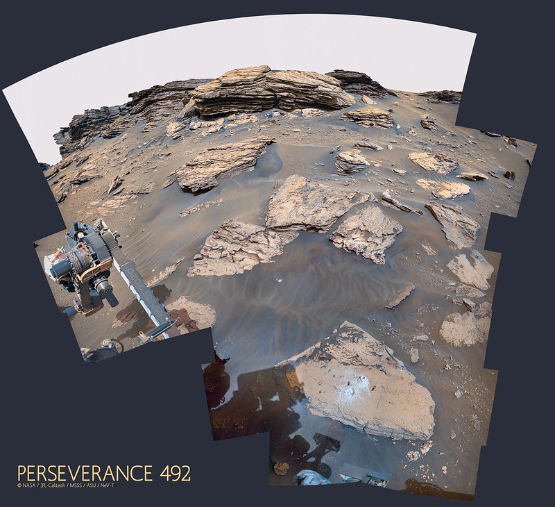
Gigapan - http://www.gigapan.com/gigapans/230074
© NASA/JPL-Caltech/MSSS/ASU/NeV-T
Posted by: Bill Harris Jul 28 2022, 04:55 PM
To get across the delta and be able to start assembling these wonderful outcrop views into a larger picture. There are going to be complex and dynamic ptocesses at work here. I'm waiting to get higher in the section and in altitude to see subaerial landforms of the delta top.
--Bill
Powered by Invision Power Board (http://www.invisionboard.com)
© Invision Power Services (http://www.invisionpower.com)