Printable Version of Topic
Click here to view this topic in its original format
Unmanned Spaceflight.com _ Perseverance- Mars 2020 Rover _ Perseverance Lands In Jezero Crater
Posted by: nprev Feb 2 2021, 10:04 AM
Percy is down!!! Congratulations to the team!!!!
We'll talk about it here. What a great day!!!
Posted by: Phil Stooke Feb 18 2021, 09:03 PM
It never gets old and boring.
Phil
Posted by: Pando Feb 18 2021, 09:05 PM
My gosh, this is absolutely amazing. Congratulations to the team!
Posted by: Antdoghalo Feb 18 2021, 09:06 PM

First image
Posted by: Pertinax Feb 18 2021, 09:07 PM
Congratulations Perseverance team and - Horray!!
Posted by: Bjorn Jonsson Feb 18 2021, 09:07 PM
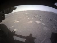
At first glance the landing site looks a bit less rocky to me than most of the earlier landing sites did.
Congratulations to the Perseverance team!
Posted by: ap0s Feb 18 2021, 09:09 PM
On the JPL feed there is a map that has been in view a few times. If the green dot is the estimated landing site it looks pretty dead center of the landing ellipse.
Posted by: Olympusmonsuk Feb 18 2021, 09:10 PM
That is how you land on Mars. Excellent.
Posted by: Phil Stooke Feb 18 2021, 09:10 PM
"At first glance the landing site looks a bit less rocky to me than most of the earlier landing sites did."
Except for the Viking and Pathfinder sites.
Phil
Posted by: fredk Feb 18 2021, 09:10 PM
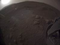
And here's the RHAZ view:
|
Posted by: Antdoghalo Feb 18 2021, 09:11 PM
Looks like it landed amidst a small cluster of rocks in a field of sand (hopefully not spirit killer quicksand).
Posted by: kenny Feb 18 2021, 09:14 PM
Fantastic, and not as rocky as the Viking or Pathfinder sites. A few blocks with angualr edges upright, and maybe some low sand drifts further back. The excitment of landing on another planet never pales...
Posted by: PDP8E Feb 18 2021, 09:17 PM
Congrats to all members of all the Perseverance Teams!
We're breathing again
Posted by: Greenish Feb 18 2021, 09:17 PM
An educated guess at landing location https://twitter.com/jccwrt/status/1362509961700536323?s=20
Posted by: Mercure Feb 18 2021, 09:19 PM
Congrats to the team!
JPL: world and outta-this-world champions at landing on other planets.
Posted by: antipode Feb 18 2021, 09:21 PM
Congrats to all involved. EDL went so fast I hardly had time to breathe.
Any idea of the rover's current orientation?
P
Posted by: kenny Feb 18 2021, 09:22 PM
above image extracted...

|
Posted by: Steve5304 Feb 18 2021, 09:23 PM

|
|
Interesting terrain....
Much different then the curiosity bedrock.
Posted by: Ectahoosis Feb 18 2021, 09:23 PM
Does one of the hazcam images show the impact/explosion of the upper stage, as they did with Curiosity?
Posted by: kenny Feb 18 2021, 09:29 PM
They are getting good data from the Rover, including its orientation in 3 dimensions. Not yet anything from the descent imager.
Posted by: scalbers Feb 18 2021, 09:29 PM
Will be interesting to learn about hazard avoidance during EDL, given that the landing ellipse includes some of the delta. Good view of the hazard maps in post #17.
Posted by: fredk Feb 18 2021, 09:30 PM
We seem to be pointing very roughly towards the SE according to the hazcams. The FHAZ view seems to show some of the SE rim or the hill just outside the SE rim (arrowed):

|
Posted by: Hungry4info Feb 18 2021, 09:30 PM
Once we get all the Sol 0 imagery down, we'll be in a better position to evaluate what's in it.
Posted by: fredk Feb 18 2021, 09:34 PM
And the RHAZ view shows what might be some of the west rim (arrowed):

|
There's probably crud on the lens cover, though they don't look all that bad.
And congratulations to the team!

Posted by: Hungry4info Feb 18 2021, 09:37 PM
That being said, this does look a lot like a crash plume.

|
Posted by: ap0s Feb 18 2021, 09:38 PM
Or just dust from the landing itself.
Posted by: Mercure Feb 18 2021, 09:40 PM
Yeah, that would be way too close for a crash plume.
Posted by: Hungry4info Feb 18 2021, 09:44 PM
I'm not sure how you managed to determine it's distance. But it does look very similar to the MSL descent stage crash plume (attached).

|
Posted by: fredk Feb 18 2021, 09:45 PM
A reminder of what MSL's plume looked like:
This new one does look similar and is also in the rear hazcam.
Edit: scooped by Hungry!
Posted by: Phil Stooke Feb 18 2021, 09:46 PM
"Interesting terrain....
Much different then the curiosity bedrock. "
Different from the current rock around Curiosity, but this is quite similar to the actual Curiosity landing site (at least in these very early hazcams)
Phil
Posted by: ap0s Feb 18 2021, 09:48 PM
The plume crash plume in the MSL photo is on/over the horizon. The apparent dust cloud in the Perseverance image appears closer than the horizon.
Posted by: Mercure Feb 18 2021, 09:52 PM
Yes, with the dust-cloud well below the horizon on such a wide-angle view it must be very close.
Remember the first Oppy hazcam shots. We thought they showed a huge outcrop. Turns out it was just a few centimeters high.
Posted by: MERovingian Feb 18 2021, 09:53 PM
First images coming in
https://mars.nasa.gov/mars2020/multimedia/raw-images/
Posted by: Hungry4info Feb 18 2021, 10:03 PM
Using the images from MERovingian's link and increasing the contrast, it is clear that the feature is at/over the local horizon.

|
|
|
Posted by: atomoid Feb 18 2021, 10:07 PM
Such a great start! the new landing system spoiled us with what seems to be perfect placement, so the interactive ESA Jezero map may not even need to relocate their 'Perseverance landing site' pin.. to get the probable skycrane crash plume in just the second downlinked image is more icing on the cake and hopefully there will be more frames to help determine how quickly the plume settles, and not to mention congrats to JPL on returning that meteorite fragment to its original home!
Posted by: climber Feb 18 2021, 10:08 PM
This one looks better

|
Posted by: jamescanvin Feb 18 2021, 10:10 PM
Only one partial that is not a thumbnail. Cropped, curves adjusted and enlarged 200%
|
|
Posted by: climber Feb 18 2021, 10:13 PM
Post landing conference scheduled at 22h30 UTC in another 15 minutes or so
Posted by: Tom Tamlyn Feb 18 2021, 10:22 PM
I guess there will always be an essential similarity to the immediate vicinity of safe landing sites... 
Posted by: Hungry4info Feb 18 2021, 10:27 PM
The landing site is likely the white dot. I suspect the "top" horizon in the Rear HazCam images is probably the cliff that defines the delta.
|
Posted by: John Moore Feb 18 2021, 10:37 PM
Super achievement...congrats to you Mars's guys and team (would love to be involved in its future exploration).
John
Posted by: climber Feb 18 2021, 10:38 PM
This would be in Canyon de Chelly square

|
Posted by: Phil Stooke Feb 18 2021, 10:39 PM
I'd rather not if you don't mind. Mapping from beyond the grave is not on my bucket list.
EDIT: Darn.. the post I was joking about has been changed!
.
Phil
Posted by: jccwrt Feb 18 2021, 10:41 PM
That's my estimate from a hazard map I saw on NASA's livestream. My sources on the mission team have told me that I'm probably within 100 m of the actual landing site (about the width of the dot in all directions), but they're still in the process of refining the position from thumbnails and HiRISE DTMs, probably won't know for sure until data comes down from an MRO pass this evening.
Looks like a good early traverse ahead! We're on the edge of the mafic floor unit, the etched floor unit is only a few days' drive away (probably doable within a day if the Ops team really wanted to move that quickly), and a relatively big crater where the rover can look deep into the crater floor materials with only a short detour.
Posted by: PDP8E Feb 18 2021, 10:41 PM
My take on the non-thumbnail-partial image...

|
Posted by: ap0s Feb 18 2021, 10:42 PM
Hm, I think you're right. Initially thought that hill was the local horizon.
Posted by: climber Feb 18 2021, 10:42 PM
Ok, I guess I have to cool down a bit...
Edit after Phil's edit : wondering if I misunderstood your post but I have to cool down a bit anyway
Posted by: Reed Feb 18 2021, 10:45 PM
Partial image combined with thumb, plus a little contrast and sharpening

|
Posted by: Steve G Feb 18 2021, 10:46 PM
Hopefully, they'll have a peek at the backshell. Curiosity didn't even get a photo op of its landing hardware.
Posted by: serpens Feb 18 2021, 10:54 PM
It is somehow reassuring to again have two rovers operating on Mars.
Posted by: kenny Feb 18 2021, 10:57 PM
not just the back-shell, Steve G, but also the skycrane which departed with a big load of unsued fuel... wonder how that ended up?
Posted by: MarT Feb 18 2021, 10:58 PM
Quick and dirty contrast enhanced equirectangular projections from the first images. Use FSP Viewer for example on Windows.
Youtube version:
https://www.youtube.com/watch?v=2AJqoiLhdkk

|

|
Posted by: Tom Tamlyn Feb 18 2021, 10:58 PM
Press conference starting now.
Posted by: Greenish Feb 18 2021, 11:04 PM
Hazcam images (thumbnails) projected rectilinearly with nominal rover level and centerline at center of image.
The diagonal FOV of these things is almost 180 deg! Lots of distortion but aiming to get a feel for horizon & may be useful for locating features.
Front Left image width: 240 deg. (boresight nominally 28 deg down, 10 deg left)

|
Front Left image width: 300 deg. (boresight nominally 45 deg down, straight)

|
Edit: MarT, nice, and you beat me to it

Posted by: kenny Feb 18 2021, 11:06 PM
how MSL Curiosity's early Hazcam image (below) looked, albeit with color, hence later than the very first B&W images.
Seems like more dust on the lens than with Perseverance.

|
Posted by: jccwrt Feb 18 2021, 11:09 PM
I have heard through the grapevine that was partially for ITAR reasons. The engineers wanted to evaluate the heat shield performance and take measurements, but because these would have been public data it was deemed to fall within ITAR restrictions. So the combination of driving out of the way and not being able to take pictures to make the trip worthwhile is why we never got landing hardware photos like we got from MER.
Posted by: MarT Feb 18 2021, 11:16 PM
The diagonal FOV of these things is almost 180 deg! Lots of distortion but aiming to get a feel for horizon & may be useful for locating features.
Front Left image width: 240 deg. (boresight nominally 28 deg down, 10 deg left)
|
|
Front Left image width: 300 deg. (boresight nominally 45 deg down, straight)
|
|
Edit: MarT, nice, and you beat me to it
Yeah, but I have corrections to make
I went with 130° FOV according to this https://www.ncbi.nlm.nih.gov/pmc/articles/PMC7686239/
Posted by: PDP8E Feb 18 2021, 11:18 PM
kenny -- that's insight ... i think
Posted by: JRehling Feb 18 2021, 11:19 PM
Hopefully, those rocks mean that some layers on the delta have been crumbly recently.
One of the things they're hoping for is to have rocks accessible that represent sediments that have been shielded from billions of years of radiation. Ideally, we could find lots of places where new rock has been exposed in the last blink on evolutionary time scales.
Posted by: JTN Feb 18 2021, 11:27 PM
Landing site from the briefing.
"Tilt of 1-2 degrees"
"We think we're facing SE"

|

|
Posted by: kymani76 Feb 18 2021, 11:30 PM

|
Congratulations to JPL on what almost seemed almost routine Mars landing.
Going to bed with best possible landing map solution at this moment. Unofficially Percy landed somewhere in the middle of Canyon de Chelly quad to the southeast of the ellipse center. We will know exactly where soon.
Does anyone know when the first HiRise imaging pass is planned?
Posted by: kenny Feb 18 2021, 11:39 PM
" kenny -- that's insight ... i think "
You're correct PDP8E -- my mistake. The dusty color image I posted is from the Insight static lander, not Curiosity.
Posted by: atomoid Feb 18 2021, 11:47 PM
Fwiw, in regards to previous post, the below appears to have been the first image sent from Curiosity, in an http://www.unmannedspaceflight.com/index.php?s=&showtopic=7397&view=findpost&p=186863
Posted by: kymani76 Feb 18 2021, 11:52 PM

|
Percy resting on the surface at the approximate landing location with delta rim on the horizon.
Posted by: Pando Feb 19 2021, 12:06 AM
Closeup of the landing area

|

|
Posted by: xflare Feb 19 2021, 12:07 AM
This is very cool https://mars.nasa.gov/mars2020/mission/where-is-the-rover/
Posted by: fredk Feb 19 2021, 12:12 AM
Does this view extend to the rim?
I estimate the rim to be roughly 2.7 degrees high from Percy (500m at 10.5km), versus around 1.7 deg for the delta (60m at 2km). On the 1/16th scale thumbnails returned so far, those correspond to around 6 and 4 pixels, respectively. I measure the feature in RHAZ to be very roughly 4 pixels high. That's consistent with the delta height, but considering the uncertainties probably also with the rim. Since the south rim (maybe actually SW) seems to be visible in the FHAZ, it seems more likely that we're seeing the rim in RHAZ and that the delta is below it and hard to see.
Posted by: JTN Feb 19 2021, 12:20 AM
Ken Farley confirmed that that is the quadrangle.
(In response to a question from Leo Enright https://youtu.be/9OCxouQGnns?t=5793 if they might fancy nipping over to Channel Islands which looks like a bit of delta outcrop, rather than / before going to the main delta, IIRC.)
Posted by: atomoid Feb 19 2021, 12:29 AM
Thanks, compare it with the https://www.esa.int/Science_Exploration/Space_Science/Mars_Express/An_interactive_map_to_explore_Jezero_crater similar but sports contour lines and panoramic view though hasnt yet updated their pin location, but it turned out to be only about 400 meters off..
Posted by: Sean Feb 19 2021, 12:32 AM
Here is an image made with HiRISE data and a color map of Jezero by Justin Cowart, using latest location & orientation info ...


Posted by: kymani76 Feb 19 2021, 12:50 AM
Short answer, no. Here is a new view with crater rim included, but I needed to lower 3D rendering resolution to get everything in one view and
there is no accounting for the atmosphere's opacity.
Clearly, crater rim is way higher than the delta.

|
Posted by: fredk Feb 19 2021, 01:12 AM
Thanks for extending that render!
I'm sure folks noticed that the hazcams were provided as pngs:
https://mars.nasa.gov/mars2020-raw-images/pub/ods/surface/sol/00000/ids/edr/browse/fcam/FLR_0000_0666952977_663ECM_N0010044AUT_04096_00_2I3J01.png
Wouldn't that be lovely if more public images were pngs...
Posted by: Phil Stooke Feb 19 2021, 01:13 AM
MarT posted the reprojected (cylindrical) versions of the hazcam images. I combined them (in a very rough way, not controlling anything properly) and put the result in a circular format, and then oriented it to face roughly to the SE. Those sort of teardrop-shaped dust drifts resemble lots of features in HiRISE images at the landing site, but I can't match these to any specific drift yet. The horizon roidge in the front hazcam imahge looks to be the south rim of the crater. The mountain on the SE rim of Jezero appears not to be visible.
Phil

|
Posted by: ollopa Feb 19 2021, 01:19 AM
(In response to a question from Leo Enright https://youtu.be/9OCxouQGnns?t=5793 if they might fancy nipping over to Channel Islands which looks like a bit of delta outcrop, rather than / before going to the main delta, IIRC.)
As far as I can see, a "quick" divert to Channel Islands is unavoidable - if Sun and Stack are right (I do not have a strong view on this).
Posted by: Phil Stooke Feb 19 2021, 01:35 AM
I would say the Channel Islands area is not likely, it's in the opposite direction to where they want to go. They might go towards it to get around the rough area but no need to go all the way.

|
Phil
Posted by: ollopa Feb 19 2021, 01:48 AM
The question is: what do you really care about? Mafic floor material? Delta material? If your rover could die tomorrow, what would you pick? And where would you go?
Posted by: ollopa Feb 19 2021, 02:04 AM
So: if your mission is to collect delta material, why would you take a sharp left when it's (putatively) right in front of you? Sorry: this arose at a meeting last month and I'm still puzzled!
Posted by: MahFL Feb 19 2021, 02:40 AM
What time is the orbiter pass this evening ?
Posted by: ap0s Feb 19 2021, 02:56 AM
The delta deposits in Channel Islands appear to have a relatively shallow slope. If they do plan to go that way maybe they're thinking that the exposure would be good and easy to access.
Posted by: Phil Stooke Feb 19 2021, 03:09 AM
They don't just plan to collect delta material. They have a whole multi-kilometer traverse mapped out which will let them sample many things. Plus, it's not certain that the hills in the Channel Islands quad are delta remnants. They have been mapped as such but that's not a guarantee. I agree they might decide to go there but it is off the intended traverse.
Phil

|
Posted by: Tom Tamlyn Feb 19 2021, 04:01 AM
So apparently an image has been received that shows skycrane in action looking up from the rover. But not released yet. 
The news was mentioned in a now-deleted tweet. But other people are now tweeting about it. E.g.,"minds are going to be blown."
It may be that so far mostly thumbnails have come down, and I can understand why JPL wants to wait until it has enough full-scale content to make a huge splash. But it's frustrating.
Posted by: Explorer1 Feb 19 2021, 04:52 AM
Press conference tomorrow, it's the best way to get gasps from the audience in the auditorium, such as it is. I still remember when the thumbnail version of the Curiosity EDL was played, and when the famous New Horizons photo was shown. Easy way to make PR buzz.
Posted by: MahFL Feb 19 2021, 05:05 AM
Jennifer Trosper did say we'd get some pics down tonight, hope she was talking about us public too... 
Posted by: Marz Feb 19 2021, 05:24 AM
[quote name='Phil Stooke' post='249809' date='Feb 18 2021, 10:09 PM']They don't just plan to collect delta material. They have a whole multi-kilometer traverse mapped out which will let them sample many things. Plus, it's not certain that the hills in the Channel Islands quad are delta remnants. They have been mapped as such but that's not a guarantee. I agree they might decide to go there but it is off the intended traverse.
Phil
/quote]
If the traverse to the Timanfaya quad is the most likely path, is that about 2 km from the landing site? Will the Ingenuity copter be used to scout the terrain first before the rover gets moving, or will it be deployed later after some critical mission objectives are completed?
Posted by: Pando Feb 19 2021, 05:32 AM
Here's the fact sheet for the helicopter. Its primary objective is a technology demonstration and concept testing, not mission support for the rover.
https://mars.nasa.gov/files/mars2020/MarsHelicopterIngenuity_FactSheet.pdf
Posted by: Greenish Feb 19 2021, 05:45 AM
Here's a stereographic nadir-pointed projection of the hazcams. Or as Phil would say, a circular view. I used the same nominal hazcam positions/orientations as http://www.unmannedspaceflight.com/index.php?s=&showtopic=8591&view=findpost&p=249776

|
(and MarT, I think we were both right; working from the same doc....horizontal FOV 136 deg/Vert 102/Diag 172. In any case, a significantly wider view than Curiosity's.)
Posted by: jccwrt Feb 19 2021, 05:48 AM
The thinking is going to be different here from other missions. Since it has a mission to collect a suite of samples to be collected and sent off to Earth, you have to assume your rover's good for its warranty and do what you can to get your sample suite. So in this case the mindset is primarily "where can I get to and what can I collect before getting myself somewhere where the Sample Retrieval Rover can pick everything up?"
To speculate on the path a bit with my geology hat, I would guess that the "Channel Islands" bluffs are deemed to be too far out of the way relative to the value they would add to the sample suite. If they do go it's probably because someone made an extremely good argument that those bluffs have a much higher chance of biosignature preservation potential than the delta rocks that they'll see by driving west. Otherwise I think we'll probably see Percy go NW, and sample the mafic and etched floor units along the way. (Both of these are a pretty high return priority, the mafic floor unit because it's a tiepoint for geomorphological surface dating, and the etched floor unit because it'll provide information on lake chemistry.) If there is a detour, it'll probably be to that crater to its north. Then they're really close to connecting up with a pre-planned traverse. It's worth noting that the JPL traverse map that Phil posted was developed for an operations training program, not a hard-and-fast plan. I suspect they'll probably stick somewhat closely to that route since it reduces duplicated work on feasibility. But I do expect there were be all types of changes made as the orbital data that traverse was developed around gets ground-truthed.
Posted by: climber Feb 19 2021, 06:26 AM
Jennifer made it clear that they want to « get rid of » the copter ASAP because it limits the use of some instruments. She said twice that theyll look for the best place around and drive to it. At least my understanding during the conference...
Posted by: MahFL Feb 19 2021, 06:35 AM
Also limits auto-nav driving as the cover protecting the copter reduces the ground clearance.
Posted by: Greenish Feb 19 2021, 06:52 AM
A first local contour map at moderate scale, with Sol0 position shown.

|
It's really great to have the https://astrogeology.usgs.gov/search/map/Mars/Mars2020/JEZ_hirise_soc_006_orthoMosaic_25cm_Eqc_latTs0_lon0_first https://astrogeology.usgs.gov/search/map/Mars/Mars2020/JEZ_hirise_soc_006_DTM_MOLAtopography_DeltaGeoid_1m_Eqc_latTs0_lon0_blend40 easily accessible right at the start from USGS. This first map here is from lower-resolution CTX and MOLA-based products produced alongside them.
Posted by: PaulH51 Feb 19 2021, 07:30 AM
Lovely map ; but I have to ask the question . Does anyone know of a map covering around the rover's current location with finer scale contours? Or any other maps that may cover the potential path of the rover with contours of any scale but the finer the better 👍
TIA
Paul
Posted by: phase4 Feb 19 2021, 08:07 AM
https://mars.nasa.gov/mars2020-raw-images/pub/ods/surface/sol/00000/ids/edr/browse/fcam/FLR_0000_0666952977_663ECM_N0010044AUT_04096_00_2I3J01.png
Wouldn't that be lovely if more public images were pngs...
FLR_0000_0666952977_663ECM_N0010044AUT_04096_00_2I3J01.png
Look at the size of that filename.

Posted by: climber Feb 19 2021, 08:42 AM
Here is what youve got when you dont set up Google Earth on the right planet 

|

|
Posted by: ollopa Feb 19 2021, 08:48 AM
(to amplify PaulH51) Does anyone have a traversibility map for Jezro? I know they've popped up at meetings, but can't find one just now.
Posted by: kymani76 Feb 19 2021, 09:31 AM
Now we know where more exactly where Perseverance landed, it is time for new maps. I just hope Phil will create mapping thread soon.
I'm using coordinates from JPL's interactive Mars2020 map (reading long: 77,450811, lat: 18,44675 from the map).
First the "clear version" map, with only HiRise image for background.

|
Posted by: kymani76 Feb 19 2021, 09:33 AM
Elevation map...

|
Posted by: kymani76 Feb 19 2021, 09:35 AM
Geologic/HiRise blend...

|
Posted by: kymani76 Feb 19 2021, 09:40 AM
..and detailed 1m contour map of the landing site environs. Still working on future traverse map.

|
Posted by: antipode Feb 19 2021, 09:45 AM
Fantastic! Thanks Kymani76.
P
Posted by: kenny Feb 19 2021, 12:54 PM
They're saying the Sol 1 (February 19) press conference will be at 18:00 GMT / UTC.
So in about 5 hours from the time of this post...
https://www.youtube.com/watch?v=Xz-Id5ZNopM
We can expect some spectacular images...
Posted by: climber Feb 19 2021, 01:03 PM
Let's try some prospectives.
I understand that they want to release Ingenuity ASAP on a as flat terrain as possible.
Experience also shows that they generally choose the easiest possible ride at the beginning of a mission.
So, my bet will be driving 850 m strait to the approx. 300 m diameter crater to the north-est which happen to be roughly half Victoria crater diameter but of the same deep (750 m - 75 m deep).
This will both be the best chance to study outcrops from Jezero floor as well as a very scenic copter flight.
My 2c as usual but why not keeping the fun at this stage ?
Dying waiting for tonight conference...
Posted by: kymani76 Feb 19 2021, 04:23 PM
As promised, first version of the map of planned traverse. It's based on the map presented yesterday by Phil (couldn't find original reference so far) and covers traverse up to sol 850.
This track is 63 km long and goes all the way to the Una Vallis which it means there will be a lot of driving ahead (Opportunity covered 23.796 km so far).
I guess they will first go around the dune field to reach starting point of this track, but this is of course pure speculation.

|
Posted by: Marvin Feb 19 2021, 04:54 PM
I found a video from JPL from Dec. 2018 called "Mars 2020 Landing Site: Jezero Crater Flyover" which I found interesting for two reasons:
1. The "landing site" is pretty close to what actually happened.
2. It shows the rover moving directly through the rough area. Would they risk moving the rover through rough terrain and sand dunes? Maybe they didn't have enough high resolution images of the area yet?

|
https://www.youtube.com/watch?v=qnZ_sidmr4Y
Anyway, it's probably just a curious coincidence.
Posted by: JRehling Feb 19 2021, 04:55 PM
I think you mean Curiosity has covered 24 km. Opportunity went about twice that.
Posted by: JRehling Feb 19 2021, 05:02 PM
I'm eager to see what possibilities exist for "remote" sensing (about 5-50 meters) when Perseverance approaches the edge of the delta deposits. SuperCam has a laser that can be aimed a few meters away. Will they be able to / choose to approach the steep slope of the delta deposits close enough to examine those layers? Obviously, we'll see them from MastCam. We will soon be looking right at some of the most interesting materials for which the landing site was chosen, but they could turn out to be just a little out of reach for now. The meter and sub-meter morphology of the edge of the delta deposits will be interesting to see as soon as those first panoramas come back.
Posted by: scalbers Feb 19 2021, 05:05 PM
I noticed that Phil's "Extended Mission" map shows a more extensive drive on top of the delta, that I hope will be closer to the actual track
1. The "landing site" is pretty close to what actually happened.
Posted by: kymani76 Feb 19 2021, 05:09 PM
Yes, thanks for correcting me...I meant Curiosity of course...
Posted by: kymani76 Feb 19 2021, 05:11 PM
1. The "landing site" is pretty close to what actually happened.
2. It shows the rover moving directly through the rough area. Would they risk moving the rover through rough terrain and sand dunes? Maybe they didn't have enough high resolution images of the area yet?
|
|
https://www.youtube.com/watch?v=qnZ_sidmr4Y
Anyway, it's probably just a curious coincidence.
This is old version of the track...refered to as western landing option...Note that landing ellipse is 2018 workshop version, not the final one.
Posted by: MahFL Feb 19 2021, 06:06 PM
Wow indeed.
Posted by: MarT Feb 19 2021, 06:09 PM
Here we go! Fresh from the conference..
High res image from MRO:
https://www.uahirise.org/releases/perseverance/perseverance-descent-large.jpg

|

|

|

|
Posted by: Explorer1 Feb 19 2021, 06:10 PM
Spectacular, truly!
And a new avatar at last.
Posted by: Bjorn Jonsson Feb 19 2021, 06:27 PM
From today's press conference, a *very* quick-and-dirty color adjustment of a screenshot showing a color image from one of the hazcams:

|
Posted by: fredk Feb 19 2021, 06:28 PM
Lots more detail on the SE rim in the new FHAZ frame. And I think we can now see the hill to the east (arrowed):

|
Posted by: JRehling Feb 19 2021, 06:35 PM
Here is an undistorted version of that I just whipped up in Photoshop, plus a selective contrast adjustment to show that distant hill.

|

|
Posted by: JRehling Feb 19 2021, 06:39 PM
In many ways, this looks like the Huygens landing site. And in some ways it is just east of an upslope feature from which fluid flowed in this direction. However, the history here should have involved much, much more reworking after the last fluid flowed, while the Huygens site is still almost certainly still being reworked by rain and flowing liquid.
Posted by: Pando Feb 19 2021, 06:40 PM
The MRO image from the press conference showed the landing site slightly more west than the actual landing location. Not a huge deal but it's an interesting discrepancy.

|
Posted by: anticitizen2 Feb 19 2021, 07:19 PM
im surprised skycrane flew northwest towards the delta, i figured it would go east.
Posted by: fredk Feb 19 2021, 07:20 PM
I was curious how steep the near delta slopes are and the answer is not very, ranging from 15 to 27 degrees:

|
15 degrees even sounds drivable, though of course the proposed route to the south is less steep and slope isn't the only factor in choosing a route.
Anyway, it's for sure not fair to call them "cliffs".
Posted by: MahFL Feb 19 2021, 07:25 PM
Can you imagine all of this with MastCamZ ?
Posted by: marsophile Feb 19 2021, 07:48 PM
If the skycrane portion has left-over fuel, could it take off again, and image some more terrain?
Maybe this would steal some of the thunder from the helicopter, but it's a disposable asset...
Posted by: MarT Feb 19 2021, 07:51 PM
My attempt at color corrections, contrast, vingette, sharpening and crop. A cylindrical projection version is also attached.

|

|

|

|
Posted by: Explorer1 Feb 19 2021, 07:58 PM
Maybe this would steal some of the thunder from the helicopter, but it's a disposable asset...
Impossible. It was violently destroyed on impact.... and cannot relay data without the umbilical. Everything was downloaded on touchdown or else lost forever.
Posted by: algorithm Feb 19 2021, 08:05 PM
I was looking at the great image FredK just posted and couldn't visualise what 15deg etc looked like, so I came across this on the net and thought it might help others as well.

|
Posted by: charborob Feb 19 2021, 08:08 PM
The raw images page is still showing only the first three images sent yesterday. Do we know if that page will be updated as soon as images come down? What is the image policy for this mission?
Posted by: kenny Feb 19 2021, 08:18 PM
One of the speakers at the recent press conference said the new images would be uploaded to the Raw Images public webste "fairly soon", but I did not detect any urgency about it.
Posted by: Steve G Feb 19 2021, 08:18 PM
Didn't we used to have a swear jar?
It's going to be a long weekend until Monday's press conference, and I'd be surprised if they released any raw images before then.
I'm not sure about the skycrane being violently destroyed on impact. It burns its fuel until depletion, so no explosion, just breakup. But I'm curious as to what speed it might have had on impact with 25% of fuel reserves remaining and no rover weight. I believe the reason they didn't want to look at the skycrane for Curiosity was fear of residual fuel that is highly corrosive.
Posted by: Steve5304 Feb 19 2021, 08:19 PM
those rocks with holes in them

What sort of process does that? I dont remember ever seeing anything like that at Gale Crater
Really hoping the team looks at those first.
Posted by: HSchirmer Feb 19 2021, 08:33 PM
What sort of process does that? I dont remember ever seeing anything like that at Gale Crater
Usually that's due to 'evaporites' that form on dry lake beds, the salt crystals get mixed in with sand or clay, then when the rock is exposed to water the salts dissolve away leaving voids. You often see that texture in 'caliche' or 'natural cement' that forms in desert regions.

|
Posted by: Steve5304 Feb 19 2021, 08:34 PM
Thanks man! Fascinating none the less. Don't recall seeing that at Gale
Posted by: algorithm Feb 19 2021, 08:38 PM
What sort of process does that?
From watching the recent press conference, I recall one of the science team was asked about the porous nature of the rocks near the rover wheels.
Her answer IIRC was that if they are volcanic basaltic rocks, then the holes (wrong term) are caused by the venting of gasses during cooling, and that if the rocks are sedimentary, the the same holes are produced from the interaction with chemically enriched water.
Posted by: atomoid Feb 19 2021, 08:41 PM
I would have suspected it to travel much further away than it did if it was programmed to fly in a line until it emptied the tank, but so much for intuition maybe that was similar to Curiosity skycrane distance travelled with the simple impact dust plume being much bigger and further away than it seems, but hopefully this time its closer to the proposed path to do some imaging if ITAR concerns aren't prohibitive, seems it would be valuable from an engineering perspective given the effort put into the suite of forensic tools for the EDL sequence.
Posted by: algorithm Feb 19 2021, 08:47 PM
Personally, if I were looking ahead to entry into this, or other atmospheres in the future, I would love to learn as much as is possible about the performance of the heatshield.
Posted by: scalbers Feb 19 2021, 08:52 PM
The rocks with holes remind me of Viking 2 (see figure 4a,4b): https://www.polartrec.com/files/members/jacquelyn-hams/docs/head_et._al_2011.pdf

|
Posted by: Tom Ames Feb 19 2021, 08:52 PM
I was also wondering what the cost/risk would be for future missions to include some rudimentary scientific and comms hardware on the skycrane, to be used in the event that there was remaining fuel. (Though on reflection I'm not certain what the benefit would be: given the high resolution imagery available from the orbiters, would an instrumented skycrane give us anything of significant extra value to the mission?)
Also, I can understand the reluctance to mess with a system whose main objective at touchdown has to be to get as far away, as safely and quickly as possible, from the rover.
Posted by: JRehling Feb 19 2021, 08:58 PM
Adding extra complexity to something like Skycrane is how you end up being asked difficult questions when an expensive mission fails.
Skycrane also, at the moment the rover is detached, is in the dead center of an area we have already imaged on the way down.
Posted by: Steve G Feb 19 2021, 09:01 PM
Throwing away a piece of hardware that could be used as a stationary lander with a seismometer and weather station is maddening, but it would take the weight away from the rover and they do want to keep some fuel margins. Exo Mars will have a functioning lander after rover deployment. I'm not sure about Tianwen-1 lander but I doubt it will be functioning independently.
Posted by: Phil Stooke Feb 19 2021, 09:03 PM
The bubbles in volcanic rocks are called vesicles. As scalbers pointed out, lots were seen at Viking 2's site. Also found on the Moon and of course right here. The crater floor may include volcanic rocks which are high priority samples for dating.
Phil
Posted by: mmatessa Feb 19 2021, 09:07 PM
Newbie here. Does the sky crane picture seem to be missing some blue?

Posted by: MahFL Feb 19 2021, 09:07 PM
Normally they are there straight away, but it's pretty obvious right now they are withholding images for the press conferences, which in my opinion is quite disappointing.
Posted by: Phil Stooke Feb 19 2021, 09:11 PM
Also maybe to get less compressed versions before release. The image policy will be the same as we are used to, just give it a bit of time to set it all up. The page can't be just a copy of MSL because there are so many different cameras. It is probably all set up offline while they check it with real data.
Phil
Posted by: James Sorenson Feb 19 2021, 09:24 PM
https://flic.kr/p/2kDcJsS
https://flic.kr/p/2kDcJuq
In regards to the color, I'd expect the PDS images when they are released to show better color correction and fidelity.
Posted by: djellison Feb 19 2021, 09:30 PM
It does not do this. See Mars Science Laboratory Flyaway Guidance, Navigation, and Control System Design. Behçet Açıkmeşe et.al.
The bridle umbilical device (BUD) has built-in retraction
springs to retract the now free bridles away from the rover top deck.
Once the flyaway controller on the DS assumes control, it first
holds the current altitude for 600 ms to allow sufficient time for the
umbilical to be cut. After the requisite hold time, the thrusters throttle
up and the DS ascends vertically for a predetermined amount of time.
Then, the DS begins to execute a turn to approximately 50 deg pitch.
The DS holds this attitude with the thrusters at 60% for 4 s. The hold,
ascent, and turn take place within 2 s, which corresponds to a total
flyaway time of 6 s
There is fuel and high pressure gas still onboard when this is finished. Flyaway consumes ~20-22kg of fuel. M2020 had ~90kg of fuel remaining so there were ~70kg of fuel left on the descent stage at burnout.
To burn to depletion would be to risk an explosive event at fuel exhaustion causing a debris field the rover would be well within.
https://static.uahirise.org/images/2012/details/cut/ESP_028401_1755.jpg < The crime scene of the MSL descent stage impact. Note the explosive nature of the scar.
The descent stage doesn't have a proper flight computer. It doesn't have it's own communications. It doesn't have it's own power generation. It doesn't have its own instruments. It doesn't have landing gear. It doesn't have enough fuel to land anyway.
This is a big discussion we all had in this place 8+ years ago. The descent stage is not a missed opportunity for a lander.
Posted by: Phil Stooke Feb 19 2021, 09:55 PM
Best I can do at the moment - I think these are the approximate fields of view of the hazcams (early version with covers on). The outlines only show he near field, the view extends beyond them. A large rock to the southeast is visible to the lower right of my SE-facing outline. The SE view doesn't match as well as the NW view, maybe I should have them closer together or my placing is a bit off.
Phil

|
Posted by: Phil Stooke Feb 19 2021, 10:06 PM
Also... arising out of a point made at the recent press conference, the Hazcam images are big and can be cropped so only part is transmitted. This shows how the wheel image fits on the wider view.
Phil

|
Posted by: djellison Feb 19 2021, 10:10 PM
I think the full frame is actually the whole frame from Front Left - and the wheel subframe is from the Front Right.
Posted by: Steve G Feb 19 2021, 10:17 PM
The bridle umbilical device (BUD) has built-in retraction
springs to retract the now free bridles away from the rover top deck.
Once the flyaway controller on the DS assumes control, it first
holds the current altitude for 600 ms to allow sufficient time for the
umbilical to be cut. After the requisite hold time, the thrusters throttle
up and the DS ascends vertically for a predetermined amount of time.
Then, the DS begins to execute a turn to approximately 50 deg pitch.
The DS holds this attitude with the thrusters at 60% for 4 s. The hold,
ascent, and turn take place within 2 s, which corresponds to a total
flyaway time of 6 s
There is fuel and high pressure gas still onboard when this is finished. Flyaway consumes ~20-22kg of fuel. M2020 had ~90kg of fuel remaining so there were ~70kg of fuel left on the descent stage at burnout.
To burn to depletion would be to risk an explosive event at fuel exhaustion causing a debris field the rover would be well within.
https://static.uahirise.org/images/2012/details/cut/ESP_028401_1755.jpg < The crime scene of the MSL descent stage impact. Note the explosive nature of the scar.
The descent stage doesn't have a proper flight computer. It doesn't have it's own communications. It doesn't have it's own power generation. It doesn't have its own instruments. It doesn't have landing gear. It doesn't have enough fuel to land anyway.
This is a big discussion we all had in this place 8+ years ago. The descent stage is not a missed opportunity for a lander.
Thanks for the clarification. The NASA landing simulation stated it burns the remaining fuel.

|
Posted by: fredk Feb 19 2021, 10:17 PM
The press release images seem to be full-resolution pngs, so that's not bad in the meantime.
With a 136 deg fov and 5120 full-res horizontal pixels (which the wheel shot is a subsample of), these hazcams will give us pretty decent one-shot colour panoramas!
The two FHAZ views are clearly with different cameras, probably L vs R (as opposed to A vs B), but there is some overlap:

|
I'll leave colour matching to the pros.
This also means we can make the first anaglyph from Jezero. First parallel-eyed:

|
And anaglyph:

|
Edit: scooped on the inset by Phil!
Posted by: Phil Stooke Feb 19 2021, 10:18 PM
Circular version of the nice cylindrical projection posted earlier today by MarT. A 'circular' version in my terminology is a polar projection, except that the radial scale is modified to shrink the foreground and expand the distant scene.
Phil

|
Posted by: Phil Stooke Feb 19 2021, 10:20 PM
Doug is (of course) right about the pics being from the left and right cameras - that's why in my version the wheel frame is skewed to match the other image.
Phil
Posted by: atomoid Feb 19 2021, 10:36 PM
interesting, they even went to the trouble of clarifying the apparent mistake by "..crashes into the terrain with no remaining fuel"
There must be good reason why an emptied fuel tank poses enough an explosion hazard they take measures to avoid, but seems counterintuitive, any explanation?
Posted by: nprev Feb 19 2021, 11:04 PM
Because there's no such thing as a completely empty fuel tank, I imagine, esp. with hypergolic fuels. There are always remnants (vapor, liquid) that won't be fully vented, so it remains an explosive hazard.
Actually was within a kilometer of so of what turned out to be a couple of guys in Korea welding an empty fuel tank many years ago...the explosion was extremely loud.
Posted by: PDP8E Feb 19 2021, 11:27 PM
here is a PHIL-O-VISION of the forward hazcam (contrast stretch)

|
Posted by: Julius Feb 19 2021, 11:46 PM
interesting to note the varying colour of surface rocks from white to grey.
Posted by: Phil Stooke Feb 19 2021, 11:50 PM
"PHIL-O-VISION"
Ouch - my precious eyes!!!
Nice view of the distant hills and mountain. The cameras on the mast will give views of these features that will blow us away.
Phil
Posted by: atomoid Feb 19 2021, 11:58 PM
Actually was within a kilometer of so of what turned out to be a couple of guys in Korea welding an empty fuel tank many years ago...the explosion was extremely loud.
hmm, nonetheless, more fuel seems to track with increased risk, as the opposite of a partially empty tank hazard for aircraft which would seem to have to do with oxygen from the atmosphere occupying the vacated space, so the hypergolic issue would seem to worsen with more fuel, assuming its stored in separate tanks, so getting rid of as much as possible seems prudent unless you desire to have a larger explosion upon impact, which is good for getting a bigger crash plume so works in our favor in that sense. Not to dither too much on the safety question as im sure theres good reason for it, my misunderstanding on this subject has my curiosity piqued.
Posted by: Julius Feb 20 2021, 12:25 AM
The adjacent olivine unit looks to be at a lower level than the spot where Percy landed. Does that mean its older terrain?
Posted by: djellison Feb 20 2021, 12:43 AM
Yup - the 'eyes' caption is just flat out wrong - I've let them know.
As you run out of fuel you can get a mix of fuel and pressurizing gas coming through the pipelines together and bad things can happen.
tl;dr don't run a rocket dry. Bad things happen.
Shut the engines down after they've done all they need to and the problem goes away. Moreover - the longer you run those engines, the longer you need to maintain attitude to keep firing in a good direction - away from the rover. As the paper I cited earlier details - that's not trivial.
6 seconds is enough.
Posted by: Steve5304 Feb 20 2021, 02:20 AM
Actually was within a kilometer of so of what turned out to be a couple of guys in Korea welding an empty fuel tank many years ago...the explosion was extremely loud.
Yes its nasty stuff. Only takes a a few ML to blowout for example, everything in a car. Nasty stuff, you want it away from the rover and science site. It only takes a minor static charge to turn it into C4
Posted by: akuo Feb 20 2021, 05:57 AM
I assumed the right front wheel image was one of the cameras on the mast looking sideways or something. So it's a full resolution subframe of the other front hazcam.
These cameras are something else than the b/w one megapixel cameras we've been used to since MER.
Posted by: Eutectic Feb 20 2021, 06:12 AM
Her answer IIRC was that if they are volcanic basaltic rocks, then the holes (wrong term) are caused by the venting of gasses during cooling, and that if the rocks are sedimentary, the the same holes are produced from the interaction with chemically enriched water.
Yup, that was Katie Morgan. If the rock is volcanic, the holes would be caused by expanding gasses and be called vesicles. Vesicular basalt has been observed on Earth, the Moon, and Mars. Alternatively, the holes, or vugs (more generically) could be caused by fluids dissolving and removing soluble material from a sedimentary rock. Oppy saw some of that.
The topic was discussed here: https://youtu.be/Xz-Id5ZNopM?t=2600
Posted by: Eutectic Feb 20 2021, 06:19 AM
The olivine unit could be simply more easily eroded. Consider Gale Crater, where much of the current topography is the result of differential erosion by wind. Soft stuff gets removed first, harder rock makes hills and ridges. However, it could also be that the olivine unit is stratigraphically lower and hence older. So stay tuned.
Posted by: Marz Feb 20 2021, 02:32 PM
This slide set has a simplified anticipated geologic history of Jezero:
https://marsoweb.nas.nasa.gov/landingsites/msl/workshops/2nd_workshop/talks/Fassett_Nili.pdf
The olivine unit is expected to have been eroded and transported, mostly as crater floor sands.
Posted by: Explorer1 Feb 20 2021, 03:14 PM
While we wait for images, Ingenuity reported in yesterday; all is well with the batteries and the base station: https://www.jpl.nasa.gov/news/nasas-mars-helicopter-reports-in
Posted by: pioneer Feb 20 2021, 03:56 PM
That rock with "holes" next to Perseverance's wheel reminds me of the rock Barnacle Bill from Pathfinder in 1997. Did it remind anyone else of it?
Posted by: MarT Feb 20 2021, 04:11 PM
Something to go by till Monday...
The youtube 360 videos are still being processed:
Sol 0 front Hazcam image:
https://youtu.be/2AJqoiLhdkk
Sol 1 front Hazcam image:
https://youtu.be/D2e6opsz6ZI
The transition from sol 0 to sol 1:
https://youtu.be/xEzCCecAn0Q
Sources:
https://mars.nasa.gov/mars2020/mission/science/landing-site/
https://mars.nasa.gov/resources/25610/hirise-captured-perseverance-during-descent-to-mars/
https://mars.nasa.gov/resources/25609/high-resolution-still-image-of-perseverances-landing/
https://mars.nasa.gov/resources/25612/perseverances-first-full-color-look-at-mars/
https://mars.nasa.gov/resources/25611/perseverances-big-wheel/

|

|

|

|

|
Posted by: HSchirmer Feb 20 2021, 05:41 PM
Phil
Yep, Barnacle Bill looks very similar- apparently BB is 'andesite', which is interesting, because that rock is mostly associated with "wet" ocean rocks being subducted and re-melted (on Earth by plate subduction, on Mars, who knows?)
Posted by: Jim Gagnon Feb 20 2021, 05:49 PM
The bridle umbilical device (BUD) has built-in retraction
springs to retract the now free bridles away from the rover top deck.
Once the flyaway controller on the DS assumes control, it first
holds the current altitude for 600 ms to allow sufficient time for the
umbilical to be cut. After the requisite hold time, the thrusters throttle
up and the DS ascends vertically for a predetermined amount of time.
Then, the DS begins to execute a turn to approximately 50 deg pitch.
The DS holds this attitude with the thrusters at 60% for 4 s. The hold,
ascent, and turn take place within 2 s, which corresponds to a total
flyaway time of 6 s
There is fuel and high pressure gas still onboard when this is finished. Flyaway consumes ~20-22kg of fuel. M2020 had ~90kg of fuel remaining so there were ~70kg of fuel left on the descent stage at burnout.
To burn to depletion would be to risk an explosive event at fuel exhaustion causing a debris field the rover would be well within.
https://static.uahirise.org/images/2012/details/cut/ESP_028401_1755.jpg < The crime scene of the MSL descent stage impact. Note the explosive nature of the scar.
The descent stage doesn't have a proper flight computer. It doesn't have it's own communications. It doesn't have it's own power generation. It doesn't have its own instruments. It doesn't have landing gear. It doesn't have enough fuel to land anyway.
This is a big discussion we all had in this place 8+ years ago. The descent stage is not a missed opportunity for a lander.
I went looking to see if a feasibility study had ever been done about soft landing Sky Crane. Came up with nothing, though I did find a number of interesting articles for those wishing to read more about Sky Crane:
https://trs.jpl.nasa.gov/bitstream/handle/2014/49150/CL%2318-6030.pdf
https://trs.jpl.nasa.gov/bitstream/handle/2014/41708/08-0255.pdf
https://trs.jpl.nasa.gov/bitstream/handle/2014/44159/13-0606_A1b.pdf
https://trs.jpl.nasa.gov/bitstream/handle/2014/44137/13-0737_A1b.pdf
Posted by: Phil Stooke Feb 20 2021, 05:51 PM
No - see the vesicular basalts collected on the Moon, e.g. at the Apollo 15 site.
"Lunar Sample 15016, better known as the "Seatbelt Basalt", is a lunar sample discovered and collected on the Apollo 15 mission in 1971 in the Hadley-Apennine region of the Moon. The rock is a 0.923 kg (2.03 lb) vesicular olivine basalt."
Posted by: Marvin Feb 20 2021, 06:09 PM
Madrid is currently "talking" to three Martian Orbiters (Mars Reconnaissance Orbiter, Mars Odyssey, and MAVEN), which are part of the Mars Relay Network.
I would guess they're testing the rover hardware, downloading images, updating the rover's software etc.
What's even more amazing (if that's possible) is that Canberra is listening to Voyager 2 which is not even in our solar system anymore!
https://eyes.nasa.gov/dsn/dsn.html

|
Posted by: neo56 Feb 20 2021, 06:17 PM
Awesome work MarT! That's really impressive for your 6th post! Keep going
Posted by: fredk Feb 20 2021, 06:41 PM
Weren't all the hazcams so far released from sol 0?
Posted by: vjkane Feb 20 2021, 07:04 PM
The color images are from Sol 1 I believe.
Posted by: mcaplinger Feb 20 2021, 07:11 PM
All the press release says is "this is the first high-resolution, color image to be sent back by the Hazard Cameras (Hazcams) on the underside of NASA's Perseverance Mars rover after its landing on Feb. 18, 2021" but I encourage you to look at the shadows from the first raw image (obviously taken on sol 0) and this image, the rover heading, the time of the press conference, and the LMST at landing and intuit which sol it was.

Posted by: Blue Sky Feb 20 2021, 07:32 PM
I thought these tall rocks in the near distance in JRehling's photo were interesting. They seem different from their neighbors and the usual flat white rocks we see most places on Mars. Brought here in outflow from the delta?

|
Posted by: MahFL Feb 20 2021, 07:52 PM
|
|
They look like mission ending rocks too...
Posted by: Greenish Feb 20 2021, 08:17 PM
It's hard to believe that these images are from "engineering" cameras... the quality of the Hazcam color image is nuts, and I think it's not even full resolution (all of the ECAMs use the same 5120 x 3840 sensor.) Really excited to see what people are doing with them. And the maps posted here too are excellent quality - just as one example, so much better than the contour maps I have recently hacked out as a QGIS newbie for Curiosity's region.
Given the number of enthusiastic new voices and new data sources, it seems a useful time to say something about image credit and copyright. I don't have any bones to pick, just want to make it easy as others did for me to "get it right" and make sure all sources have proper credit and nobody gets themselves or each other upset or in trouble. (Hard to believe, I know... but it has happened here before.)
- Short version: CREDIT YOUR IMAGES. Preferably ON the image. Scientists spend literally their entire careers doing the work to generate these. They just might stop sharing them before publication if we abuse the privilege.
- Longer version: http://web.archive.org/web/20190913115709/http://www.planetary.org/explore/space-topics/space-imaging/copyright.html a on this a few years back (it was on planetary.org until recently, thus the link to archived version). Excerpt:QUOTEProper attribution is important to the space imaging community, both professionals and amateurs. For space images, credit is due not only to the image processor, but also to the organizations that produced the original data. Each data set from each instrument on each spacecraft might have a different proper attribution.
There is also an https://www.planetary.org/articles/20120608-rush-copyright-nasa-images on copyrights. And http://www.unmannedspaceflight.com/index.php?act=boardrules have the following to say:QUOTE5. Copyright
Images from NASA missions are in the public domain. The creation of mosaics, composites, anaglyphs, projections, and other treatments of NASA-based raw data constitute the creation of an original work. As such, the copyright for this derived imagery lies with the individual who created it. Copyright does not have to be explicitly stated to be enforceable.
The European Space Agency (ESA) has different policies regarding copyright and use of their mission images and data. Some data is in the public domain while other material is restricted in its uses. We recommend you familiarise yourself with these policies. [1 2] Users of data from other space agencies (eg: JAXA, INSA) should familiarize themselves with the agency's copyright policy before posting.
5.1 If you wish to use images from unmannedspaceflight.com, ask permission from its creator first, especially if you intend to use the images for profit. For legal advice on copyright, http://www.studentservices.soton.ac.uk/copy/copylegal.html%20.
5.2 Give credit where it's due. Credit should be given to the institutions responsible for generating the data as well as to the person who processed it.
[If better placed folks and/or site MODS want to clarify or expand on anything, or move this to a different spot, please do.]
Does anyone already have a list of the proper instrument credit lines we should be using for Mars 2020 where different from MSL?
Posted by: JRehling Feb 20 2021, 08:54 PM
The rocks around the landing site, I would presume, arrived in one of two ways:
1) Carried downslope over 3 billion years ago in the river.
2) Flung long distances by spallation from impacts.
Where we see a huge boulder, (2) seems more likely than (1). Where we see two huge boulders near one another, that's even more true.
I don't think the Nile, Mississippi, Yangtze, etc. carry huge boulders downstream. A catastrophic flood caused by impact melt or volcanism could do that. But that's not the supposed story of Jezero.
The fairly consistent flat surface, even where rocks rise through the sediment/dust seems to me to indicate erosion, either chemical or aeolian. Where a couple of boulders stick up above that general plain would seem to indicate a different composition that resisted erosion.
Posted by: Explorer1 Feb 20 2021, 08:58 PM
Putting my lawyer hat on (how rarely I can do that on this forum!), can you clarify what you mean by this? The raws are public domain, and that can't be changed by the science team (at least as far as NASA is concerned; ESA images are another matter!).
Those links are an excellent explainer, by the way. I recommend everyone read them!
Posted by: mcaplinger Feb 20 2021, 09:08 PM
The below would be my preferences, but MSSS has no PIs on this mission so my opinion counts for even less than usual. MSSS is frequently omitted in such cases, e.g., explicit guidance for LROC is just NASA/GSFC/ASU.
Engineering cameras should be the same as MSL: NASA/JPL-Caltech
LCAM: NASA/JPL-Caltech/MSSS
SHERLOC: NASA/JPL-Caltech/MSSS/LANL
Mastcam-Z: NASA/JPL-Caltech/ASU/MSSS
I'm not sure about the others.
Posted by: Blue Sky Feb 20 2021, 09:32 PM
It is hard to tell how far away those rocks are - it might just be 5m. As far as I can make out in pictures, the cameras are only about 50cm above the ground. Those rocks do not extend above the horizon, so might be only 15cm tall. But they are definitely of a different composition then the general white stuff.
Posted by: fredk Feb 20 2021, 10:30 PM
The sun was lower in the west for the colour FHAZ, compared to the nearly 4pm LMST of the sol 0 image. Considering that that colour frame was released less than 24 hours after landing it had to be taken sol 0, late afternoon.
Posted by: fredk Feb 20 2021, 10:34 PM
The hazcam wheel crop is a full-resolution crop, and the [released (and maybe downlinked too)] uncropped colour hazcam is downsampled 4x4. And yeah, they are really nice cameras!
Posted by: climber Feb 20 2021, 10:35 PM
When the first picture came in I heard somebody saying that we were 15 m (or was it 25 ?) from a rock visible on MRO pictures.
Posted by: alan Feb 20 2021, 11:21 PM
Are there L and R hazcam images down? I would like to see Mystery Man standing next to one of those odd boulders.
Posted by: Explorer1 Feb 21 2021, 01:33 AM
Keith Cowing of NASA Watch says that a full initial panorama has been successfully taken and images are coming down soon. He has been very accurate over the years, I trust him and his sources completely: https://twitter.com/NASAWatch/status/1363293299562475525
Posted by: mcaplinger Feb 21 2021, 05:18 AM
The specifics might be true (I can neither confirm nor deny) but his spin is basically garbage. See Emily L's twitter for a more accurate take, specifically
Posted by: John Whitehead Feb 21 2021, 05:30 AM
There must be good reason why an emptied fuel tank poses enough an explosion hazard they take measures to avoid, but seems counterintuitive, any explanation?
Posted by: Webscientist Feb 21 2021, 09:24 AM
Some diversity on Mars!
The stones near the wheel are quite weird! in particular this stone which looks more like a sponge or old gruyère than a stone 
If blocks of water ice are hidden inside the rocks why not sublimation events that generate the holes?

|
Posted by: kymani76 Feb 21 2021, 09:38 AM

|
I made a new 3D interactive map of the Perseverance landing site. It's available by clicking at:
https://arkeomapia.si/3d/M2020sol0/
No large boulders visible...it looks quite flat.
Posted by: xflare Feb 21 2021, 10:38 AM
Kind of weird that we are having to rely on "leaks" and cryptic tweets to find out what is happening with Perseverance.
Posted by: nprev Feb 21 2021, 11:25 AM
Every program has its own strategy for EPO. My impression is that they want to have something--maybe a few somethings--to hopefully blow some minds at the Monday presser, and in order to do that they need time to process & integrate the data coming down for the past few days.
There's something to be said for that. Instead of holding daily press conferences with a few frames here and there from (for example) a fairly complete EDL video--perhaps even with sound!--why not wait till the whole thing's down & processed & assembled? Then follow that up with a full color panorama, then answer amazed & delighted questions in front of the news cameras.
Now that's a press conference worth covering live on the major networks right there. Not a lot of people are gonna complain about something spectacular like that preempting an "I Love Lucy" rerun. Plus, it's a much more efficient use of time for all involved, esp. the science leads, most of whom would likely much rather be poring over the data as it comes in instead of sitting on the stage at the Von Karman Theater every day for the next week wishing it was over so they could go back to work.
But that's just my guess.
Posted by: mcaplinger Feb 21 2021, 02:35 PM
For some definition of "they" that doesn't include the team that may be true. Do you really think we can't process the data in a couple of minutes to a release-ready state?
You (and we) are just going to have to wait until Monday at 11 AM PST for the press conference.
Posted by: Blue Sky Feb 21 2021, 03:58 PM
Wasn't the European mission to a comet was criticized for holding back data from public release? Their excuse was that their academic institutional partners wanted to see it first. Some academics just hate releasing information to the public because they would rather get the credit when their papers are published. Its a stupid system.
Posted by: Art Martin Feb 21 2021, 04:34 PM
These early major press conferences are going to be over with after this week and releases should go back to normal. It makes perfect sense to make them the focal point of attention and awe. NASA needs the public to be wowed and supportive when they have attention like this. We are the minority segment here and not the target but I have no doubt the staff know our value to distribution and analysis after the luster fades away. We'll be awash in images and data very soon.
Posted by: ugordan Feb 21 2021, 04:41 PM
Yes, but does that explain that even the single full resolution, greyscale hazcam image posted on the raw site has still not been finalized?
Not to mention the color hazcams they already showed at the presser. I can wait for the EDL engineering camera sweetness until the presser for that maximum wow factor, they deserve that chance as far as I'm concerned, but they sure could have put a filter on uploading those camera data and not prevent "basic" hazcam imagery from being posted.
It's as if the raw image site is just plain dead, almost 3 days after the landing. My memory might be fading, but I don't recall this sort of thing happening with MSL.
Then again, I'm not a U.S. taxpayer so I'm not allowed to complain, this is just an observation. I see a lot of comments on the web about "entitlement" and, to be fair, yes, we were spoiled by NASA's raw image release policies in the past. On the other hand, doesn't NASA pride themselves on full disclosure and public engagement? Unless this raw image site thing is a bug, it sort of indicates a revert to ESA and other space agency policies. Well, you can't have your cake and eat it, can you? Unless "public engagement" nowadays simply means taking questions from social media during live broadcasts.
Posted by: Greenish Feb 21 2021, 05:35 PM
I am not a lawyer, so I won't speak to the legality; nor an academic scientist, so I won't pretend to know their whole perspective. But as I was perusing the UMSF archives prior to my post above, I learned a lot from http://www.unmannedspaceflight.com/index.php?showtopic=3817, including a message from the Cassini Imaging PI, Carolyn Porco, http://www.unmannedspaceflight.com/index.php?showtopic=3817&view=findpost&p=84211.
I suggest reading the full post... but here's some snips that I found compelling.
....
[I]magine sending out an invitation to a party, describing how fantastically wonderful your party will be, working for weeks on end making all the arrangements for this party, expecting to have a big blow-out that no one will ever forget, and then having all your invitees go instead to the party next door. That would be pretty deflating, wouldn't it?
Now, instead of party and all I've described above, imagine it's not weeks but 14 years of very hard work, requiring enormously long periods of time during which you had to clear the decks of everything, including any semblance of a normal life, to achieve success. And that one of the things you *most* looked forward to, from all your hard work, was presenting to the world the best, most beautiful, most memorable images anyone had seen. In other words, having the world come to your party. And after all your hard work, someone else cuts you out of the equation, throws a party without you. After all your hard work, someone else presents your work to the world.
I ask you: Would *you* be disappointed?
....
As I said I've mostly benefitted from people's lessons learned on this site. It's clear there was some drama at the time, but the resolution I suspect has contributed to the healthy balance we have now.... and probably we should move any further discussion to some other thread. Cheers.
Posted by: Greenish Feb 21 2021, 05:39 PM
LCAM: NASA/JPL-Caltech/MSSS
SHERLOC: NASA/JPL-Caltech/MSSS/LANL
Mastcam-Z: NASA/JPL-Caltech/ASU/MSSS
Thanks a ton Mike, exactly what I wanted to confirm. IMO your preferences carry a lot of weight here, at least -- given that your ongoing engagement has been a huge part of maintaining that healthy balance of public use of the raws vs. letting the scientists do their work and present it!
Posted by: vikingmars Feb 21 2021, 06:15 PM
I totally agree with you. There is so much at stake with this release and, obviously, it can wait a few more hours.
The goal is to make front line titles in the media to help gaining more budgets for space programs, such as the MSR mission and the future of Artemis.
The space policy still has to be reviewed by the new Administration and we can wait: the more this release impress people (and their representatives at Congress), the more budget you will get in the near future
Posted by: Steve G Feb 21 2021, 06:20 PM
One thing that we have never seen are rocket exhaust plumes on Mars. The upward looking shots of the skycrane will give us that first glimpse.
Posted by: nprev Feb 21 2021, 07:25 PM
Alright. Reminder for everyone to read and heed rule 1.3 right http://www.unmannedspaceflight.com/index.php?act=boardrules re astrobiology, and also to note that the topic of this thread is the early days of Percy's sojourn on Mars, not astrobiology.
Yes, we the admin/mod team know that the mission has some explicit astrobiological data acquisition goals. No, we are not going to allow that discussion to monopolize coverage of this mission nor the inevitable secondary speculation that equally inevitably would veer into tin hat territory.
There are innumerable other places on the web for that sort of thing. This is not one of them.
Three posts hidden.
Posted by: MahFL Feb 21 2021, 08:20 PM
I think rule 1.3 may need amended as they are looking for fossils...that's the whole point of the mission...
Posted by: Aldebaran Feb 21 2021, 08:28 PM
|
|
Ejecta seems to be a more likely explanation. They are interesting though.
Posted by: xflare Feb 21 2021, 08:36 PM
Yes, we the admin/mod team know that the mission has some explicit astrobiological data acquisition goals. No, we are not going to allow that discussion to monopolize coverage of this mission nor the inevitable secondary speculation that equally inevitably would veer into tin hat territory.
There are innumerable other places on the web for that sort of thing. This is not one of them.
Three posts hidden.
Some???
Well This is going to be tricky
OBJECTIVE B: ASTROBIOLOGY
Determine whether an area of interest was suitable for life, and look for signs of ancient life itself.
Perform the following astrobiologically-relevant investigations on the geologic materials at Jezero Crater:
Determine the habitability of an ancient environment.
For ancient environments interpreted to have been habitable, search for materials with high biosignature preservation potential.
Search for potential evidence of past life using the observations regarding habitability and preservation as a guide.
Once Perseverance has a chance to study the landing site and its history, the team should be able to identify whether any locations in the crater were habitable (were liquid water and the chemical building blocks of life present there in the past).
Posted by: JRehling Feb 21 2021, 08:54 PM
With exoplanets, there hasn't been any trouble with discussing the "habitable zone" without the discussion going off the deep end. The key is that it is plainly just a term relating to a range of a single parameter, temperature a range that certainly exists without any speculation of a sci fi nature.
Perseverance is looking for "habitable" times/places in Mars's past. I don't think that forces anyone into wild speculation. We're looking for places that were warm and wet, with the possibility of carbon chemistry. If this proceeds nominally, I don't think Perseverance will require rules changes (or board chaos) any more than Curiosity did.
Posted by: xflare Feb 21 2021, 08:58 PM
Thosewere Curiosity mission objectives, Perseverance will do that and much more......
Posted by: nprev Feb 21 2021, 09:11 PM
Everybody, 1.3 will not be amended or modified at this time nor at any time in the foreseeable future, and this is the consensus opinion of the admin/mod team after discussions.
As to why, consider what happened this morning. There were two throwaway comments by two members re astrobiology. A third member posted a link with excerpts from a full-up astrobio paper.
That escalated quickly. All OT, all in violation of 1.3. Like life itself, it would quickly evolve and envelop the Forum.
We ain't havin' it. As has been said many times, there are other places to have such discussions.
Moving on.
Posted by: mcaplinger Feb 21 2021, 10:06 PM
MSL conveniently landed on a Monday. Most of this, as far as I can tell, is due to a "5-day-a-week during business hours" mentality on the part of somebody and not being able to have a press conference over the weekend.
I don't know of anyone on the team that agrees with this policy, but it is above our pay grade.
Posted by: climber Feb 21 2021, 11:28 PM
Thomas Zurbuchen tweet

|
Posted by: alan Feb 21 2021, 11:31 PM
Lots of hazcam images at the raw image site https://mars.nasa.gov/mars2020/multimedia/raw-images/
Posted by: Explorer1 Feb 21 2021, 11:35 PM
Fresh pasture at last!
Interesting to see material already in the wheels, blown in from the landing thrusters.
Posted by: Marcin600 Feb 21 2021, 11:38 PM
"Mission controllers (...) have received the first status report from the Ingenuity Mars Helicopter": https://mars.nasa.gov/news/8867/nasas-mars-helicopter-reports-in/
"... both the helicopter, which will remain attached to the rover for 30 to 60 days, and its base station (...) are operating as expected..."
Posted by: JRehling Feb 22 2021, 12:06 AM
The rear left hazcam shows one pronounced but small dune nearby. It also shows what appears to be a single streamer of a cloud in the sky.
Posted by: Marvin Feb 22 2021, 12:17 AM
Yeah, I thought I saw some in an earlier image. I wonder if there's any material on the top deck?
I'm really impressed by the new wheel design:

|
"Made of titanium tubing formed with the same process used to make high-end mountain bike frames."
The MMRTG power source has an operational life of 14 years. So if they take care of it, this rover could last for years and years.
Posted by: fredk Feb 22 2021, 12:21 AM
And we're continuing to see pngs, even with the Bayered images! So we can now trivially deBayer, without having to deal with jpeg artifacts, at least with the hazcams:

|
Posted by: Tom Ames Feb 22 2021, 12:37 AM
Re. the front Hazcams: is "A" the outboard of each L/R pair and "B" inboard?
Posted by: machi Feb 22 2021, 12:41 AM
Quick panorama from the rear Hazcam.

|
Posted by: djellison Feb 22 2021, 12:48 AM
A is the pair connected to the A flight computer, and B is the pair connected to the B flight computer
Image from https://link.springer.com/article/10.1007/s11214-020-00765-9
|
Posted by: djellison Feb 22 2021, 12:50 AM
I genuinely have no insider info for M2020 ECAM stuff - I'm guessing like everyone else - but it would appear....
Mars_Perseverance_RLB_0002_0667129492_604ECM_N0010052AUT_04096_00_2I3J01
Mars_Perseverance_RLG_0002_0667129481_373ECM_N0010052AUT_04096_00_2I3J01
Mars_Perseverance_RLR_0002_0667129466_057ECM_N0010052AUT_04096_00_2I3J01
Stack to an RGB image...... RLB being the Blue, RLG being the Green etc etc
Images like Mars_Perseverance_FRE_0000_0666958359_772ECM_N0010052AUT_04096_00_0LLJ01 - the E is raw and needs to be debayered ( I used Fitswork )

|
|

|
Posted by: erwan Feb 22 2021, 01:16 AM

|
Here is the corresponding rear right hazcam image. I think we see the delta remnants as a long mesa, between the plain in the foreground and the crater rim high hills in the background.
Posted by: Greenish Feb 22 2021, 01:29 AM
Hopefully of use to folks here! A query that returns JSON for the raws.

|
The full URL is https://mars.nasa.gov/rss/api/?feed=raw_images&category=mars2020&feedtype=json&num=50&page=0&order=sol+desc&&&extended=
Posted by: machi Feb 22 2021, 02:00 AM
Thank you Doug for your remarks about colors!
Here is color panorama from rear Hazcam (Sol 2).
https://www.flickr.com/photos/109586958@N03/50967979076/
Posted by: erwan Feb 22 2021, 02:17 AM
|
Posted by: Bill Harris Feb 22 2021, 02:19 AM
Not really. Academia is driven by "publish or perish" and the people doing the science need to have first dibs on the data. We can wait; the Universe will be around for a while.
--Bill
Posted by: PaulH51 Feb 22 2021, 02:33 AM
Interesting to see material already in the wheels, blown in from the landing thrusters.
And no Morse code holes for them to escape. Should be nicely polished in there are a few years time
Posted by: tdemko Feb 22 2021, 02:44 AM
Could the vesicular-looking loose rocks on the surface be eolian weathering of regolith from a vuggy bedrock, with the vugs filled with a softer mineral and subsequently weathered out?
Maybe chicken-wire gypsum or some other evaporite sulfate?
The fresher looking bedrock looks like it is structureless and mottled at the hazcam resolution.
Posted by: JRehling Feb 22 2021, 03:25 AM
The immediate vicinity of the landing site is not the terrain that motivated Jezero as the destination but it's still interesting to contemplate: Are we seeing material that was emplaced in an aqueous environment, or are we seeing material that was emplaced over a once-aqueous environment?
I suspect the latter. In Gusev Crater, Spirit (through no fault of engineering or its drivers) failed to make direct contact with the lacustrine environment for which it was chosen, and a considerable depth of regolith was emplaced after Ma'adim Vallis flowed into it. The age of Gusev's river and Jezero's should be relatively comparable to the long subsequent era of impact and wind emplacement of material that followed. Those boulders we see, also, seem to indicate impact emplacement.
If there's anything lake-based in the immediate vicinity of Perseverance now, then it had to have come downwards, either as erosion mixed a once-higher lakebed with the sort of windborne/impact-flung material that filled Gusev, or in mass movement from the delta deposits, which are still relatively far away.
I suspect that not much of what we're seeing within 50 meters of the rover now ever touched the lake that was here. That will change profoundly as we approach the delta. I'd be happy to be proven wrong about the first part.
Posted by: fredk Feb 22 2021, 03:29 AM
Posted by: MahFL Feb 22 2021, 04:25 AM
The small cliffs on the delta remind me of Victoria crater's rim.

|
Posted by: Don1 Feb 22 2021, 05:04 AM
Wasn't this supposed to be a lava flow? The stuff in the foreground looks sedimentary. I recall some rocks from Gale Crater near Glenelg that looked a lot like reef rock but turned out to be mudstone with vugs. In the background there are some angular black shards that could be basalt thrown out of a crater.
Posted by: JRehling Feb 22 2021, 05:39 AM
The 2015 literature interpreted the immediate area of the landing site (as well as quite a bit that's around it) as "volcanic flow" but a 2020 USGS work calls it "volcanic ash or eolian airfall deposit that drapes underlying topography."
So, as I'd posited earlier, I don't think much of what we see soon is likely to be related to the aqueous environment that Perseverance came to Jezero for. Maybe some baubles here and there that took a curious journey?
https://pubs.er.usgs.gov/publication/sim3464
"Volcanic ash or eolian airfall deposit that drapes underlying topography. Correlates with unit Nnp2 based on common stratigraphic position and shared textural and morphologic characteristics. Emplaced during the Late Noachian before deposition of unit NHjf1. May have been modified by subsequent lacustrine activity during deposition of units NHjf1 and NHjf2. Dark, smooth surface texture near unit NHjf2 is due to a dark mantle deposit or erosional lag derived from erosion of unit NHjf2. Previously interpreted by Schon and others (2012) and Goudge and others (2015) as an extrusive volcanic flow."
Posted by: Don1 Feb 22 2021, 07:05 AM
I think we are on the Nle unit which is mid-Noachian and therefore really old. If that is correct then these might be the oldest rocks ever visited by a Mars rover.
They do mention carbonates associated with some of the crater floor units. When I saw the light tone of the rocks I thought about carbonate, but I suppose it is more likely to be volcanic ash that got saturated in water producing the vugs.
It'll do for instrument tests. I'm quite curious to see how the new tech preforms, especially the Raman. Then they can head for the delta.
Posted by: Phil Stooke Feb 22 2021, 07:31 AM
A rough reprojection of the current hazcam views gives a nice view of the landing site - north approximately at the top.

|
The delta edge is clear with the hills of Jezero's rim behind it (height exaggerated in this projection). At lower right the forward view includes some bright rocky patches among the drifts which made the location clear to me. This is a HiRISE image (number in the file name if you save it) with Percy superimposed at close to the correct size and orientation.

|
Phil
Posted by: kenny Feb 22 2021, 08:16 AM
Bravo Phil.... that is beautiful!
Plenty of flat space around to launch a chopper.
Posted by: Ant103 Feb 22 2021, 11:56 AM
Few pictures I did after the release of the first batch of "raw" images
https://db-prods.net/marsroversimages/Perseverance/2021/RRGB_0000_0666958309_241ECM_N0010052AUT_04096_00_2I3J02.jpg
And Sol 2 (just RGB, no reprojections) :
https://db-prods.net/marsroversimages/Perseverance/2021/RLRGB_0002_0667129466_057ECM_N0010052AUT_04096_00_2I3J01.jpg
https://db-prods.net/marsroversimages/Perseverance/2021/FLRGB_0002_0667129448_123ECM_N0010052AUT_04096_00_2I3J01.jpg
All I can say is those camera are AMAZING ! And the pictures we have are just downsampled versions. Can't wait for the full sampled !
Posted by: HSchirmer Feb 22 2021, 01:49 PM
Yep, interesting though, without any holes, the interior of the wheels should eventually accumulate heavy materials like panning for gold, and act like a slow motion "gem tumbler" to wear off "desert varnish" eventually revealing the underlying mineralogy.
On the other hand for "a curious journey" after seeing the "eccentrics" I couldn't help but think of "racetrack playa" where large rocks embedded in ice move impossibly long distances across an ephemeral lake in a normally dry lakebed.
Which raises the possibility that those eccentrics are "depth charges" i.e. rocks deposited onto the frozen surface of the lake which eventually melt through the ice and fall to the lake bottom.
Posted by: Decepticon Feb 22 2021, 02:27 PM
Feb. 22, Monday
2 p.m. EST Mars 2020 Perseverance briefing (All Channels)
Posted by: Marvin Feb 22 2021, 02:48 PM
2 p.m. EST Mars 2020 Perseverance briefing (All Channels)
Maybe we'll get some images from the mast cameras. The hazard cameras are better than those of Curiosity, and the protective covers did their job preventing lens damage during powered descent.
Posted by: neo56 Feb 22 2021, 06:03 PM
Here is my take on these marvelous first Hazcam pictures. Correction of the vignetting, of the lens distorsion and levels.
That's such a lovely place!
https://flic.kr/p/2kDZCEp
https://flic.kr/p/2kE4L7u
https://flic.kr/p/2kE4dXu
https://flic.kr/p/2kE4LxV
https://flic.kr/p/2kE4P9L
Posted by: JRehling Feb 22 2021, 06:21 PM
There may be some interesting stories for individual rocks, but I have trouble seeing how any lake-related rocks would be near Perseverance now. Some rocks surely made it to the bottom of the lake when it existed, but there have been billions of years of aeolian and impact deposit after the lake was gone, and the depth of the deposit is probably much greater than the diameter of any individual rock.
Perhaps a rock rolled off the deposit at considerable velocity, but there's a lot of dusty ground for any such rock to roll hundreds of meters.
If I had to guess, out of any hundred rocks around Perseverance now, how many are lake-related, I'd bet on zero. If there are any, though, they have an interesting story behind them.
Posted by: Pando Feb 22 2021, 06:26 PM
2 p.m. EST Mars 2020 Perseverance briefing (All Channels)
I'm really looking forward seeing the landing video!!!
Posted by: Marz Feb 22 2021, 06:28 PM
here's a geologic map of Jezero:
https://agupubs.onlinelibrary.wiley.com/cms/asset/0266bf57-fcd3-475f-8602-65b56aa7076f/jgre20381-fig-0004-m.jpg
If my bearings are correct, we are on what is called the Volcanic Floor, which was post-depositional to the delta-fan units.
The map is from this paper: https://agupubs.onlinelibrary.wiley.com/doi/full/10.1002/2014JE004782 by Goudge et al
Posted by: machi Feb 22 2021, 06:34 PM
That's such a lovely place!
Great images Thomas!
Here are two enhanced resolution images (using super-resolution techniques) from front and rear hazcams:
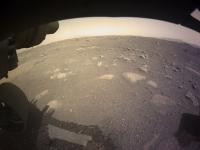
|

|
Posted by: markril Feb 22 2021, 06:51 PM
|
It just keeps speaking to me...
Posted by: Phil Stooke Feb 22 2021, 06:53 PM
There was a rock at the Pathfinder site called 'Mini-Matterhorn'.
Phil
Posted by: fredk Feb 22 2021, 06:54 PM
Yikes those are impressive. I was thinking that, since the R, G, and B frames are subsamples of different pixels on the original Bayer sensor, there should be some way of recovering more resolution from them. Did you take advantage of the RGGB pattern or is that generic super-resolution?
Posted by: stevesliva Feb 22 2021, 06:57 PM
You guys keep mentioning these Pathfinder names, and it keeps reminding me of downloading some basic HTML tables of thumbnails on pink webpages over dialup. That was a lot cooler than getting AW&ST from the library.
Posted by: Pando Feb 22 2021, 07:15 PM
Holy **** these videos :0
Astounding!
Posted by: machi Feb 22 2021, 07:18 PM
Thanks!
It's generic super-resolution which takes advantage of the RGGB patern.
(At least I suppose that's the case.)
Better SNR thanks to summing images also helps with processing.
Posted by: Marvin Feb 22 2021, 07:25 PM
The supersonic parachute in action:

|
They hinted there may be a message in there, where are the crypto guys
Posted by: stevesliva Feb 22 2021, 07:51 PM
Astounding!
Yup! https://www.jpl.nasa.gov/news/nasas-mars-perseverance-rover-provides-front-row-seat-to-landing-first-audio-recording-of-red-planet
The loose spring rolling around the heat shield was an interesting detail they pointed out...
Posted by: stevesliva Feb 22 2021, 07:59 PM
EDL microphone did not record data during EDL. 
Posted by: alan Feb 22 2021, 08:16 PM
New color images on the raw page.
Posted by: Phil Stooke Feb 22 2021, 08:23 PM
I had my rover too big in the landing site image above - but in the right place so that's something.
Phil
Posted by: Steve G Feb 22 2021, 08:50 PM
Mars is really picking on the microphones. The two previous ones sent; one on the Mars Polar Lander, which crashed, and Phoenix, which was never turned on, and now the EDL audio was lost on this mission.
Posted by: kyokugaisha Feb 22 2021, 08:53 PM
Looks like some exposed delta outcrops visible in the new images.
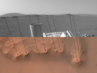
|
Posted by: Phil Stooke Feb 22 2021, 08:55 PM
OK, now we know we are really on Mars - first circular panorama.
Phil

|
Posted by: Pando Feb 22 2021, 09:28 PM
All the parts on the surface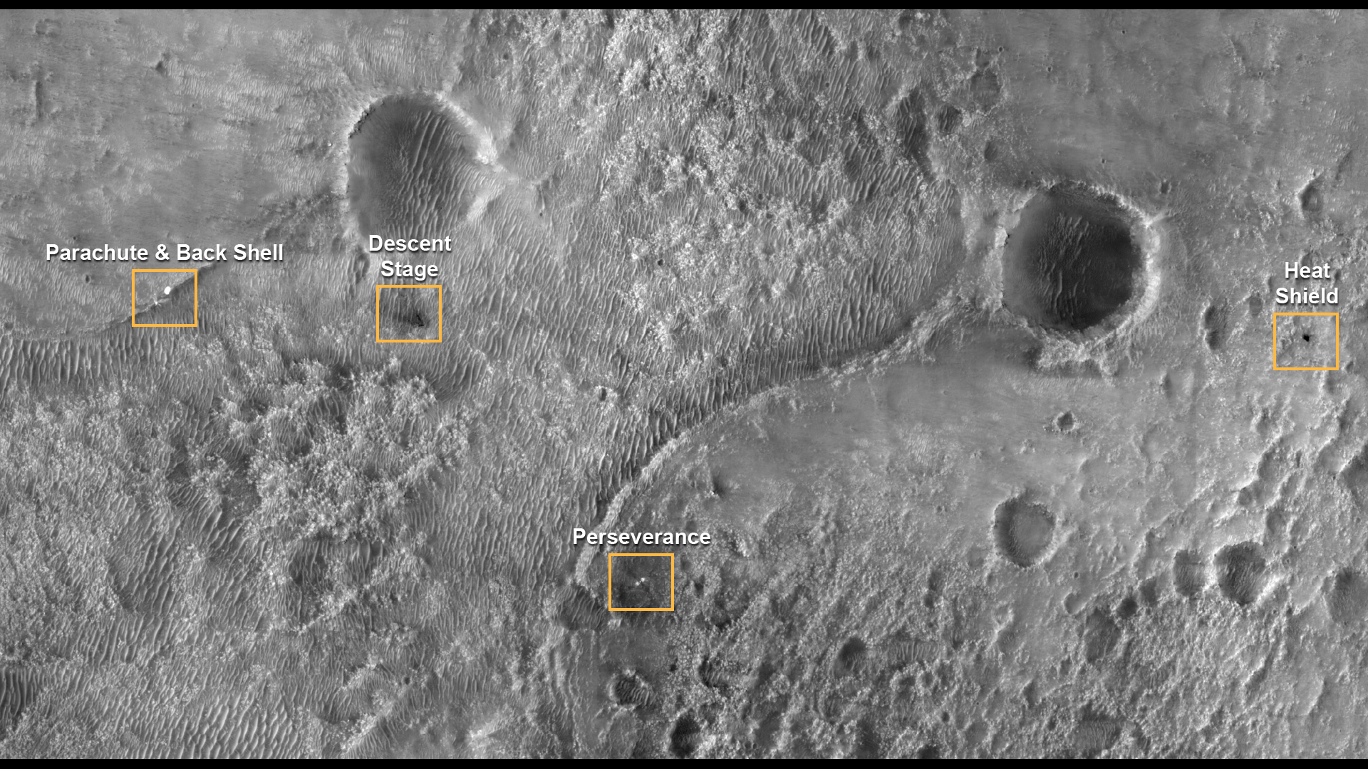
https://mars.nasa.gov/resources/25630/perseverance-and-mars-2020-spacecraft-components-on-the-surface/
Posted by: neo56 Feb 22 2021, 09:29 PM
Well done Phil! I was looking forward to this one.
Posted by: imipak Feb 22 2021, 09:34 PM
Can't stop watching the EDL videos. Astounding, and yet just what you'd expect, and I for one got a bit emotional during Skycrane -- I hadn't registered that there were cameras on the descent stage and rover upper deck, pointing at each other, so that was quite unexpected.
Also interesting to compare to the various interpolated videos people (I forget who, sorry) made from the still frames from Curiousity's downward pointing camera. The first such that showed up on a search on YouTube was this -- the faked up audio is a slight twist of a small knife, but no matter, they'll get EDL audio next time no doubt )
https://www.youtube.com/watch?v=Esj5juUzhpU
Posted by: JRehling Feb 22 2021, 09:35 PM
Amazing, Phil. This is quite the landing site with that scientifically portentous delta over there in the distance, and the crater rim much of the rest of the way around!
Posted by: Phil Stooke Feb 22 2021, 09:42 PM
And a different reprojection to look further out.
Phil

|
Posted by: neo56 Feb 22 2021, 10:10 PM
I played with the Navcams, it's fantastic to have them in color! But the large FOV will make it more difficult to stitch them together.
https://flic.kr/p/2kE7BqE
https://flic.kr/p/2kE7SEn
https://flic.kr/p/2kE4wVA
https://flic.kr/p/2kE8vbV
https://flic.kr/p/2kE4s8Q
Posted by: ugordan Feb 22 2021, 10:17 PM
There's been a new batch of color navcams posted on the raw site, but these ones have an odd blue hue to them. https://mars.nasa.gov/mars2020-raw-images/pub/ods/surface/sol/00002/ids/rdr/browse/ncam/NRF_0002_0667130543_401CPG_N0010052AUT_04096_0A00LLJ01.png.
I hope it's a raw image site issue and not something with the camera.
Posted by: Art Martin Feb 22 2021, 10:20 PM
My first attempt at a quick and dirty anaglyph. Most Nav cam shots are only from the left. This was one I found with both left and right. Not sure if they are a perfect match but it gives some sense of the distance of things.
https://flic.kr/p/2kE4QUbhttps://flic.kr/p/2kE4QUb
Posted by: Marvin Feb 22 2021, 11:01 PM
Joey Murphy has found a morse code message in the parachute pattern:

|
https://twitter.com/spacecomm_joey/status/1363936680466644995?s=21
Now I can back to enjoying the images. You guys here are wizards.
Posted by: alan Feb 22 2021, 11:19 PM
There's been a new batch of color navcams posted on the raw site, but these ones have an odd blue hue to them.
If I click on color processed nothing comes up.
Ima guess these are blue because they are unadjusted.
Posted by: MahFL Feb 22 2021, 11:40 PM
The rise of the slope between Percy and the valley is quite a bit greater than it first appears.
Posted by: Tom Ames Feb 23 2021, 12:45 AM
|
|
https://twitter.com/spacecomm_joey/status/1363936680466644995?s=21
Now I can back to enjoying the images. You guys here are wizards.
I don't think that's the real code. (If you follow the scheme given--red = dit, white = dah--it actually spells out "BPL".
It looks instead like there are 71 4-bit words, in 3 groups of (37, 17, 17).
Not ASCII, AFAICT.
Posted by: Marz Feb 23 2021, 12:51 AM
Is that the northern delta-fan in this image? I know we're headed to the western delta, but was curious if and when percy may get a better view.
https://flic.kr/p/2kE4wVA
Posted by: mcaplinger Feb 23 2021, 12:57 AM
https://mobile.twitter.com/FrenchTech_paf/status/1363992051734478852
There may be more stuff though.
Posted by: atomoid Feb 23 2021, 01:00 AM
https://mars.nasa.gov/resources/25630/perseverance-and-mars-2020-spacecraft-components-on-the-surface/
It looks like the parachute/backshell got caught straddling that little ridge, might be hard to reach it if that is a target, but should be visible to supercam once we get a few tens of meters past the foreground, i think in the direction of https://mars.nasa.gov/mars2020/multimedia/raw-images/NRR_0002_0667130999_035ECM_N0010052AUT_04096_00_2I3J01 ?

|
Posted by: Tom Tamlyn Feb 23 2021, 01:11 AM
I hope it's a raw image site issue and not something with the camera.
I get an error message when I click on the example link.
Posted by: Steve G Feb 23 2021, 01:16 AM
You can definitely see something in the NavCam panorama released today. Likely the backshell.

|
Posted by: MikeH Feb 23 2021, 01:19 AM
This guy and his father solved the parachute message riddle:
https://mobile.twitter.com/FrenchTech_paf/status/1363992051734478852
It was an A=1, B=2 encoding, using 10-bit numbers.
Posted by: fredk Feb 23 2021, 01:24 AM
Interesting how the blasted areas are lighter than the pristine areas - from my recollection usually the dust is lighter so the ground darkens when you remove the dust.
Posted by: fredk Feb 23 2021, 01:42 AM
This navcam is a crop at full resolution, and standard deBayering works fine:

|
But the hue is wonky out of the box.
This is 1/16th of a full frame! I wonder if we'll ever see a full-res full frame sent down.
Posted by: Explorer1 Feb 23 2021, 01:45 AM
Nice catch! Curiosity's hardware was hidden by local topography the entire time it was on the crater floor. The backshell is also between the landing site and delta, so perhaps a higher chance of sneaking a peak during the traverse? The dunes don't look that bad in the MRO imagery, with plenty of hard ground between them to navigate.
Posted by: serpens Feb 23 2021, 01:47 AM
The deck is remarkably clean after landing compared to Curiosity's experience.
Posted by: fredk Feb 23 2021, 01:53 AM
Posted by: PDP8E Feb 23 2021, 02:08 AM
Steve G - I'm pretty sure that is the backshell too.
The sightlines to the southernmost closest delta match up (well... with my 6-inch rule on my monitor and my map of Jezero at least)

|
EDIT
Sol-1 rear Hazcam

|
...well will see...
Posted by: Steve G Feb 23 2021, 02:27 AM
The "forbidden zone" they want to circumnavigate looks a lot more benign from the ground than the HIRISE orbital imagery.
Posted by: alan Feb 23 2021, 03:13 AM
https://twitter.com/ucidennis/status/1363946097379446787
https://twitter.com/3Dmattias/status/1363677824566104064

|
Posted by: erentar Feb 23 2021, 03:13 AM
Ive spent some time georeferencing the available images, here is the result (https://drive.google.com/file/d/1kZEU5YhnQFMLWsFt13MzARCnxZ0mM6ET/view?usp=sharing)
I'd eyeball the error to be ~2-4m
You can import the gtiff file to any gis and measure distance and bearing accurately, maybe it'll help locating the debris
Rough locations in decimal lat long:
Parachute: 77.4319, 18.4517
Descent stage: 77.4418, 18.4522
Heatshield: 77.4743, 18.4553
Perseverance: 77.4508, 18.4446
Is there a release date for the raw products with the labels in them?
Posted by: Pando Feb 23 2021, 03:54 AM
The sightlines to the southernmost closest delta match up (well... with my 6-inch rule on my monitor and my map of Jezero at least)
EDIT
Sol-1 rear Hazcam
...well will see...
It doesn't match up with any known debris.
I've annotated the panorama showing roughly where the debris should be on the horizon. Unfortunately nothing is visible due to topography.
Image credit: NASA/JPL-Caltech
|
|
Posted by: JRehling Feb 23 2021, 05:30 AM
Odd quirk to the mystery object: It appears to be reflecting light on the side that, on all of the rocks in the vicinity, is shaded. That seems to imply a very reflective surface on a flat object. But we're close to the limit of resolution to pick out useful details.
Posted by: MahFL Feb 23 2021, 06:06 AM
Setting sun on Sol4.

|
Posted by: atomoid Feb 23 2021, 06:21 AM
right, it does seem to have the wrong side shaded, given the limit of resolution. It shows up in all 3 of the image pairs taken in that minute or so sequence, but shows up best in the https://mars.nasa.gov/mars2020/multimedia/raw-images/NRB_0002_0667131054_903ECM_N0010052AUT_04096_00_2I3J01, so if it truly doesnt map out to a piece of EDL hardware and is a chance glint off a polished rock face, it should be unnoticeable once an image with the sun at a different angle comes down. The crosseye/anaglyph/parallel view shows its indeed on the further of those ridges:

|

|

|
Posted by: markril Feb 23 2021, 07:16 AM
Here's a before-and-after gif animation of the skycrane debris field (needs to be clicked to animate):

|
I wish the https://www.uahirise.org/releases/perseverance/descent-stage-irb.jpg was of higher quality, but you can still make out quite a few pieces scattered about.
Posted by: Phil Stooke Feb 23 2021, 07:53 AM
Nice animation!
Regarding the bright feature on the near horizon. The bright side is not facing the other way compared with nearby rocks. Note that many rocks in the area have a bright flat top. The extra-bright feature is sloping towards us and to the left a bit, but it's getting its upper (sloping) surface illuminated. Some foreground rocks have a very bright right side but the other faces are in shadow because they are near-vertical. There is nothing off about the illumination, it's just the rock shapes.
Phil
Posted by: ugordan Feb 23 2021, 08:29 AM
Yes, those images seem to have been pulled. I can't find the corresponding-looking Navcam-L image anymore.
Posted by: Quetzalcoatl Feb 23 2021, 11:14 AM
Thank you for this good Gif.
I admit that I have a hard time distinguishing them. But living near Paris (France) Im probably far too far away.
Posted by: climber Feb 23 2021, 11:43 AM
Regarding the bright feature on the near horizon. The bright side is not facing the other way compared with nearby rocks. Note that many rocks in the area have a bright flat top. The extra-bright feature is sloping towards us and to the left a bit, but it's getting its upper (sloping) surface illuminated. Some foreground rocks have a very bright right side but the other faces are in shadow because they are near-vertical. There is nothing off about the illumination, it's just the rock shapes.
Phil
Back when Oppy was driving to Victoria crater we had such rock we called « The Beacon » that proved to be a rock. We had a lot of arguments and a lot of fun with it until weve been close enough to be sure what it was. Are you saying weve got another beacon here ?
Posted by: Marvin Feb 23 2021, 12:32 PM
I zoomed in, with some quick enhancements. I like the rock with a reflective side idea...

|
Posted by: Ant103 Feb 23 2021, 12:45 PM
My first attempt at stitching the full panoramic from Navcam, Sol 2. So far, so good, but still perfectible. I'll try adding the bottom part of the rover deck later.
https://db-prods.net/marsroversimages/Perseverance/2021/Sol2_pano.jpg
Posted by: erentar Feb 23 2021, 12:59 PM
With panoramas, having compass bearing on the pictures would help a lot with coordinating what we see with what's on the map. I do not know if this is achievable without the product label (tell me)
like we have with MSL, but unfortunately that has to go through JPL MIPL which is apparently very secretive. JPL really is conservative when it comes to releasing their code.
|
|
Posted by: eoc Feb 23 2021, 01:21 PM
Right Rear Hazcam, Sol 0, processed to emphasize differences in saturation.

|
Posted by: Steve5304 Feb 23 2021, 02:44 PM
So in everyone of the images their appears to be a faint object in the air. Im sort of ruling out a spec of dust because its the same altitude in every shot...but im no expert
Could that be diemos? Just wondering.
You gotta look hard or you will miss it in the sky
https://db-prods.net/marsroversimages/Perseverance/2021/Sol2_pano.jpg
Posted by: Explorer1 Feb 23 2021, 02:52 PM
If it's in every image in the same spot, then it is certainly a speck of dust! Couldn't be anything else.
Posted by: fredk Feb 23 2021, 02:58 PM
If you mean the dark spot, for sure not Deimos, since that would not appear dark (it's surface would be just slightly brighter than the sky since it's light would be added to that of the sky and likely invisible in navcam during the day). Dust speck is a good bet.
Posted by: djellison Feb 23 2021, 03:35 PM
There are reasons to be critical about how things have gone in terms of getting data out to the public over the past few days. But this is absolutely untrue.
Those mosaics from Curiosity are auto-generated after images are received after every drive, and every time there are updated images to add to them. They get sent out to the MSL internal server, a thumbnail gets emailed out to the team, and it gets uploaded to the MSL public website all using the same end-of-pass script. https://mars.nasa.gov/msl/multimedia/mosaics/ . This is not very secretive. Its about as proactively open as its possible to be. It happens entirely hands off - no human in the loop - automatically. If I have been on shift sequencing images ...that public website is the place I go to see the end result first thing in the morning. I would expect that M2020 will probably get to the same point in the near future.
MIPL isnt secretive. They have posters and presentations about their work at almost every planetary science conference Ive seen. See https://trs.jpl.nasa.gov/handle/2014/42355 for example. As for conservative when it comes to releasing their code - most of the MIPL code base is open source
https://www-mipl.jpl.nasa.gov/vicar_open.html
Powered by Invision Power Board (http://www.invisionboard.com)
© Invision Power Services (http://www.invisionpower.com)