Printable Version of Topic
Click here to view this topic in its original format
Unmanned Spaceflight.com _ Juno _ Juno Perijove 57
Posted by: volcanopele Oct 19 2023, 09:08 PM
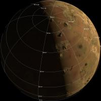
I know the first close Io flyby is still a couple of months away but I'm going to go ahead and start up the topic now with a few preview images that the global map from PJ55 into the pixel scale, lighting conditions, and orientation of the highest resolution images that JunoCam would take (illuminated by the sun, there's always a chance for Jupiter-shine images), based on the current reference spk and c-kernel:
|
|
|
|
|

|
This also assumes an image cadence of 1 every other rotation (so 1 per minute).
info about the encounter:
PJ57 12/30/2023 08:36:00.681 1500.021 63.694 94.641 30.047 108.885 3.418 228.269 248.805 21.175
Posted by: volcanopele Oct 20 2023, 10:32 PM
Edited to include the first six instead of the first and third (skipped one) using the global map I generated from PJ55 images.
Posted by: Antdoghalo Oct 21 2023, 12:42 AM
Will this flyby get an entry on the Gish Bar Times?
Posted by: volcanopele Oct 22 2023, 01:08 AM
at this point, probably not (grumble grumble prior publication). That being said, I've considered doing a follow-up video for Youtube and might do some live events for the flyby and stream my processing work.
Posted by: Decepticon Oct 22 2023, 03:37 AM
Very excited to see any changes at Loki.
Posted by: Tom Tamlyn Oct 23 2023, 01:39 AM

Juno is going even closer?

Posted by: Explorer1 Oct 23 2023, 03:34 AM
Yes, December 30th and February 3rd, only 1500 km!
Posted by: StargazeInWonder Oct 23 2023, 04:51 AM
The next two flybys will be close enough that Doppler radio science is expected/hoped to provide meaningful science regarding Io's interior. The Galileo Orbiter made several flybys even closer than this; I am unsure what, if any, benefits may be obtained as a result of superior technology or differences between the geometry of these flybys and those made by Galileo.
The combination of PJ55 and the next three close Io flybys will provide something approaching global coverage at about the resolution of PJ55 or better. So all told, it's going to be a pretty nice dataset given that the surface of this world changes over time and the last detailed imagery of many areas is ~20-25 years old.
Posted by: john_s Oct 23 2023, 05:33 PM
I've heard that the Juno gravity data will have higher precision than the Galileo data, so a couple of close Juno flybys will provide a considerable improvement in understanding Io's gravity, beyond the half-dozen flybys that Galileo accomplished.
John
Posted by: mcaplinger Dec 23 2023, 11:22 PM
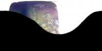
We're less than a week out from the Io flyby. The first Junocam image should be taken at 2023-364T08:37:21 +/- 15s and the first four images are at 60s spacing.
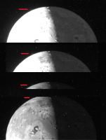
Posted by: volcanopele Dec 24 2023, 03:11 AM
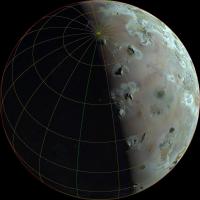
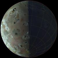
Preview images using the latest ephemeris and c-kernel. First image according to that kernel has the green frame centered on Io at 2023-Dec-30 08:37:07.177. Preview images are spaced every 2 rotations.
|
|
|
|

|
|
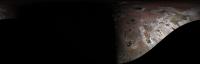
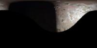
I take it that there are not images prior to C/A/ Looked like there might be some decent imaging at ~19 km/pixel of the anti-Jovian hemisphere. A bit disappointed at the lack of Jupiter-shine images but given what happened in PJ56 I totally understand.
Posted by: mcaplinger Dec 24 2023, 04:10 AM
Correct. Maybe we should have taken one, but Io starts leaving the FOV illuminated limb first by the time the resolution has gotten decent, so we judged it wasn't worth it.
Posted by: Antdoghalo Dec 24 2023, 01:28 PM
Would have been cool to test if there was airglow from the volcanoes. Will the SRU be taking pictures of the night side?
Posted by: volcanopele Dec 24 2023, 02:57 PM
They can take one. I'm hoping they can get one showing Tonatiuh, a large lava flow (~500 km long) north of Zal that formed between 2008 and 2018 (between first ground based detection of a hotspot to a 150-km shifting of the flow front in 2018). Kinda difficult given the longitude (~65-85°W) but even something just showing the general morphology of the flow would be useful enough. For example, I'm pretty sure that the eastern end is the source based on ground-based data, but there are no visible edifices at that end in older imagery. There is one toward the western end in Galileo imagery, and maybe the "western expansion" in 2018 was just a fresh, westward flow from that source.
Posted by: volcanopele Dec 24 2023, 08:32 PM
|
having a bit too much fun prepping for a preview video...
Posted by: volcanopele Dec 28 2023, 02:39 AM
Wow, okay, so an hour long preview video is processing now on Youtube. Should be available in a few hours.
Posted by: Antdoghalo Dec 28 2023, 12:53 PM
https://www.youtube.com/watch?v=pLRPS9LZmn0 It finally posted!
Posted by: kymani76 Dec 28 2023, 05:48 PM
Wonderful video, thank you Jason!
I also made an approximate flyby "map" to mark the occasion.
|
Posted by: scalbers Dec 30 2023, 07:55 PM
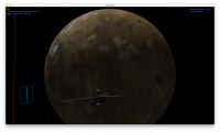
Just checking on the outbound portion of the flyby with Eyes on the Solar System.
https://eyes.nasa.gov/apps/solar-system/#/sc_juno/distance?to=io
Thanks Jason for your very nice preview video.
Posted by: mcaplinger Dec 31 2023, 12:21 AM
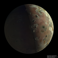
First Io image is up on social media, e.g., https://www.facebook.com/NASASolarSystem/
missionjuno data post to follow shortly.
Posted by: vjkane Dec 31 2023, 12:50 AM
missionjuno data post to follow shortly.
That's a nice sharp image
Posted by: Phil Stooke Dec 31 2023, 01:03 AM
Yes, and great detail on the night side too.
Phil
Posted by: StargazeInWonder Dec 31 2023, 01:39 AM
Wow. My eyes watered. That first image is already great.
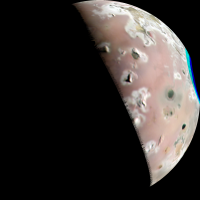
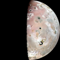
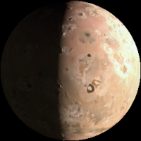
Posted by: volcanopele Dec 31 2023, 01:52 AM
after fretting for a month about these images after seeing the PJ56 images.... Mike, if I ever see you at a conference, I owe you a beverage of your choice.
Posted by: StargazeInWonder Dec 31 2023, 02:22 AM
When I saw the color image on missionjuno, I said, "You're kidding me." Holy smokes, there is surely science value to follow, along with the beauty.
Posted by: mcaplinger Dec 31 2023, 02:28 AM
Images are on missionjuno now.
Here's the lat/lon grid for the first image.
|
Posted by: Kevin Gill Dec 31 2023, 02:46 AM
First pass on PJ57-22:
https://flic.kr/p/2ppCrZL
https://flic.kr/p/2ppCrZL
Posted by: scalbers Dec 31 2023, 02:51 AM
Yes this is amazing and will be interesting to add to the cylindrical maps. One previously named feature I can note is Vivasvant Patera as per https://stevealbers.net/albers/sos/features/combined_io_lon_zero_center.png.
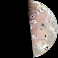
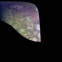
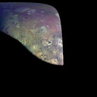
Posted by: volcanopele Dec 31 2023, 03:13 AM
My take:

|
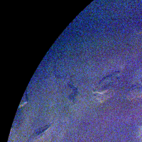
Posted by: Hungry4info Dec 31 2023, 04:05 AM
Here's the only thing I've found that vaguely appears to resemble a plume. It's visible in at least four different raw image slices.
|
Posted by: volcanopele Dec 31 2023, 04:31 AM
I haven't gotten that far yet but my best guess at this point would be Xihe.
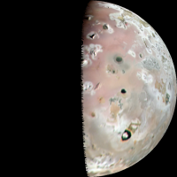
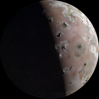
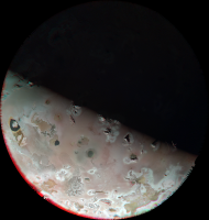
Posted by: volcanopele Dec 31 2023, 05:03 AM
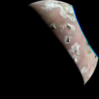
My new favorite volcano is visible in Jupiter Shine!!!!!
|
this is Tonatiuh, a 500-km long lava flow that wasn't there 15 years ago, at all. This is also the site of that plume that JunoCam saw at the end of 2018.
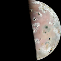
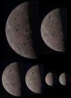
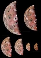
Posted by: volcanopele Dec 31 2023, 06:17 AM
Full set of six:
|
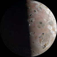
|
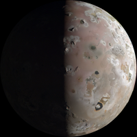
|
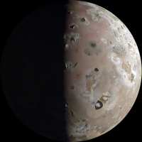
|
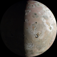
|
|
Plus a nice bonus color anaglyph
|
Posted by: ugordan Dec 31 2023, 06:27 AM
Absolutely spectacular stuff, well worth the wait. Congrats to the team for pulling it off.
Posted by: Greenish Dec 31 2023, 08:51 AM
Couldn't resist brushing off StereoPhotoMaker for a crosseye stereo pair, hope you don't mind borrowing your image (from @volcanopele on twitter before I even got here).
Somewhat tortured view but really puts it in perspective for me.
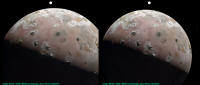
|
Posted by: Bjorn Jonsson Dec 31 2023, 09:01 AM
Congratulations to the Juno team. The high quality of these images compared to PJ56 is a nice surprise to me. Even the blue images have clear details on the nightside.
Posted by: Nahúm Dec 31 2023, 09:14 AM
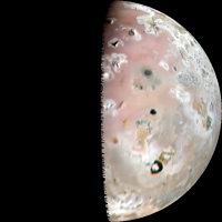
Congratulations to Juno team! There seems to be some "visible" changes at Loki compared to Voyager 1 images!
|
Posted by: john_s Dec 31 2023, 02:48 PM
Wow- there's real stereo information on those big mountains- nice job, Jason!
Has the camera performance actually improved since PJ56? It looks like it.
John
Posted by: Webscientist Dec 31 2023, 03:29 PM
A captivating time in the Juno mission around Jupiter !
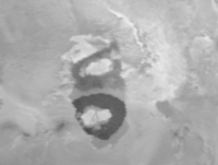
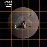
Regarding the mountains or volcanoes of Io, there is a remarkable shadow of a mountain or volcano in a high-resolution view of Io during that flyby. I think we can approximate the potential height of the mountain.
I took one of the images presented by Jason to evaluate the size of the topographic structure and to evaluate the potential height of the mountain or volcano.
I assume a diameter of around 1302 pixels for the disk of Io (real diameter of 3643.2 km).
From the peak of the mountain to the limit of the shadow, there is a distance of around 56 pixels (From location A to B, there is a distance of 56 pixels).
That distance of 56 pixels must represent aroud 157 km (56 pixels /1302 pixels * 3643.2 km).
If we have the angle of the Sun above the horizon from location B (location of the limit of the shadow related to the peak of the mountain), we should be in a position to approximate the potential height of that mountain that may be closer, in appearance, to "Mont Cervin" (The Matterhorn) in Switzerland than "Le Piton de la Fournaise" (Peak of the Furnace) in the island of "La Réunion" !
|
Posted by: fredk Dec 31 2023, 04:42 PM
There is enough information in the image itself to determine the angular height of the sun at that peak, based on the position of the terminator. But the peak is pretty close to the terminator so the angle is quite low and will exagerate the relief considerably.
Posted by: mcaplinger Dec 31 2023, 05:35 PM
Yes, certainly.
Buried in the Facebook comments from NASA Solar System Exploration:
Credit to Jamie Carter at Forbes.com for actually finding that comment and reporting it.
Posted by: Bjorn Jonsson Dec 31 2023, 05:37 PM
Yes, definitely a very large improvement since PJ56. The image quality is now probably comparable to PJ55.
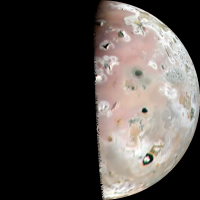
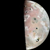
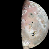
This is a preliminary version of image PJ57_22:
|
North is up. The brightness of the nightside has been increased to show details there.
Posted by: StargazeInWonder Dec 31 2023, 05:40 PM
There's some detail around Loki in the color that implies changes, too, although to be absolutely certain we'd have to check against differences in filters.
Posted by: StargazeInWonder Dec 31 2023, 05:47 PM
At the hazard of gushing too much for board rules, this is just amazing stuff, way better than expected. Amazing work by the team and the citizen imagery mavens. I notice that the good stuff came out much sooner after the flyby than with P55; I was ready to chew my fingernails waiting a little longer.
Add this to the long list of tremendous opportunistic science where a mission funded for one purpose wonderfully observed another target. The Ganymede and Europa observations were very nice but this is astonishing. I look forward to learning what the radio science tells us about Io's innards.
Posted by: scalbers Dec 31 2023, 06:47 PM
A very rough / preliminary idea of how one of volcanopele's images fits in a cylindrical map (before and after)
|
|
Posted by: Kevin Gill Dec 31 2023, 07:22 PM
Another go using PJ57-23 with decorrelated colors and darkness boosting. I'm so happy the camera performed as well as it did and am loving the results that everyone is coming up with :-)
https://flic.kr/p/2ppMscT
https://flic.kr/p/2ppMscT
Cylindrical Map:
|
Posted by: Nahúm Dec 31 2023, 07:38 PM
Of course, mine was a quick comparison and it clearly needs a thorough alignment and analysis but both images were compared using the blue bands, so there might be some changes after all!
Posted by: john_s Dec 31 2023, 08:40 PM
The color around Loki is certainly fascinating. These are, I think, the highest resolution color images of Loki ever obtained (the nearest competition being the Voyager 1 approach 4-frame color mosaic). Same goes for the terrain further north, of course.
John
Posted by: Brian Swift Dec 31 2023, 09:37 PM
Kicked off the processing pipeline this morning, expecting to be greeted by PJ56 quality images that were going to require a lot of TLC, and gasped when this came up...
|
A fine ChristMSSS present for us all.
Posted by: Brian Swift Dec 31 2023, 10:05 PM
And Exaggerated Color/Contrast version
|
Posted by: StargazeInWonder Dec 31 2023, 10:37 PM
There are at least three (apparent) calderas in the imagery that show a diffuse, reddish coloration that trails off to the west (from this view, clockwise). Is this
Evidence of a Coriolis effect on plumes?
Evidence of something of a faint exospheric wind, or something to do with the jovian EM environment?
Purely coincidence? (n=3, not much to write home about
and perhaps there are also contrary cases to be pointed out)
Posted by: scalbers Jan 1 2024, 02:49 AM
Here are a some 4K maps using one image from volcanopele and one from Kevin Gill, first before:
https://stevealbers.net/albers/sos/jupiter/io/io_rgb_cyl_in_4k.png
now with the new images added:
https://stevealbers.net/albers/sos/jupiter/io/io_rgb_cyl_2023_4k.png
I wonder if the changes at Loki represent a switch in the location of active plumes or simply deposits? Happy New Year to you all!
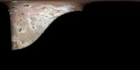
Posted by: volcanopele Jan 1 2024, 05:47 AM
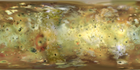
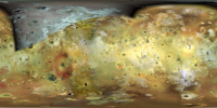
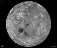
Preliminary versions of maps. No photometric correction, and I won't want to average the final product, but the Jupiter shine product is probably final:
|
|
Posted by: scalbers Jan 1 2024, 02:59 PM
A blinking animation between the second map I posted above with Jason's nighttime map (some filtering applied):
https://stevealbers.net/albers/sos/jupiter/io/io_4k_day_night_roll.png
Posted by: Antdoghalo Jan 1 2024, 04:23 PM
The Jupitershine area really improves coverage on almost the entire area of that large northern hemisphere low resolution area. I really hope we can get further processing of that.
Posted by: StargazeInWonder Jan 1 2024, 04:55 PM
The ideal processing of the Jupitershine areas might benefit from applying an asymmetrical filter to the pixels. Low signal to noise produces a speckling effect which is clearly an artifact and brings out some hot pixels that over-respond, and this makes the colors garish on a very small scale. Smoothing out the values in each filter to bring the hot ones down to the local median might improve this greatly.
Posted by: scalbers Jan 1 2024, 05:15 PM
Fyi I had applied the https://docs.gimp.org/en/gimp-filter-noise-reduction.html with a setting of 12. This may be related to what StargazeinWonder mentions, and would work better if applied to the original image prior to reprojecting onto the cylindrical projection.
Posted by: vjkane Jan 1 2024, 05:16 PM
Slightly off topic, but since this is the current active Juno forum: I understand that the Juno extended mission is expected to end by September 2025. Is this driven by a decision to dispose of the orbiter (presumably into Jupiter)? Or is this a current funding deadline with another extension possible?
Posted by: mcaplinger Jan 1 2024, 05:37 PM
I thought it was stated somewhere (OPAG?) that disposal was no longer required with the current orbit, so I suspect it's the latter. Depending on ongoing spacecraft health and funding availability, of course.
Posted by: volcanopele Jan 1 2024, 05:58 PM
I'll look into some post-processing steps today. My first thought was running each mosaic through a median filter in ISIS prior to stacking.
EDIT: really not liking the results. The red filter, while noisy, has pretty good detail so I really don't want to smooth that. I suspect that using the noise filter in ISIS would help a lot, but I am not wanting to dive into yet another research topic today after spending all day yesterday trying to wrangle the geometry...
Posted by: StargazeInWonder Jan 1 2024, 09:32 PM
To zoom in on the problem, here are magnified patches of one of Jason's images, blue filter only, from the dayside and Jupitershine side, normalized to about the same overall brightness.
Obviously, the difference isn't due to Io itself, but the higher share of noise compared to signal in the darker imagery.
Median over a local window (3x3?) is one solution, which of course loses some spatial resolution.
We might beat this by combining information from the three color filters, presuming that the peaks and valleys of the speckles will vary from one filter to another and there is usually not sharp color contrast on the same spatial scale as edges in general albedo. So, maybe average the three filters to produce a grayscale image, apply median (2x2?) to that, and then color it with images that apply a larger median (eg, 4x4) to each of the color filters.
I've gone down a similar road with some astrophotography images, and there may be more wisdom out there in the community that processes images of deep sky objects (galaxies and nebulae). It's almost an entirely different paradigm than the imagery of planets (dayside), where you can always get all the luminance you want.
|
Posted by: scalbers Jan 1 2024, 10:00 PM
Yes this may take some doing to set things up in an optimal way. Another example is in the IDL environnment with an FFT related filter. This is more of a random noise situation as I know FFT's can also work with periodic noise.
https://www.nv5geospatialsoftware.com/docs/RemovingNoise.html
Posted by: mcaplinger Jan 1 2024, 10:11 PM
Is there really useful color information in the Jupitershine part of the image? A quick look at pj57-031 (the only image with TDI of 6) suggests to me that the green channel by itself is telling you most of what there is to know. Certainly the blue channel is pretty noisy.
We will almost certainly take more nightside images on PJ58, but my inclination is to go with longer TDI and only one channel (green, or perhaps red.)
Posted by: Antdoghalo Jan 2 2024, 12:04 AM
Will there be an SRU image for PJ58 as well?
Posted by: volcanopele Jan 2 2024, 01:10 AM
Posted by: StargazeInWonder Jan 2 2024, 01:19 AM
Taking one of Jason's images and applying a 3x3 median to the Jupiter shine side, I noted first that the blue was much brighter than it was on the dayside, no doubt due to greater noise. So, I turned the blue down about 40%.
This was the result. There is real color information at some resolution, but that is binning at a greater level than 3x3.
I guess that reducing the blue in a linear way was incorrect, and it would have been better to reduce it more in the areas where blue was darkest and kept it higher where blue was brighter (the terrain is a more neutral white/gray). As mentioned earlier, the noise is not symmetric because in either dark areas or bright it can push the output brighter, but in dark areas, it can't push the output into negative.
|
Posted by: mcaplinger Jan 2 2024, 01:36 AM
Have to think about that. There are timing/cadence tradeoffs between TDI and number of bands. Could do green on one spin, red on the next, probably.
Posted by: volcanopele Jan 2 2024, 03:47 AM
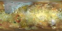
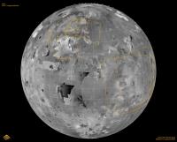
daylit map (includes images 22 to 25)
|
Posted by: volcanopele Jan 2 2024, 05:43 AM
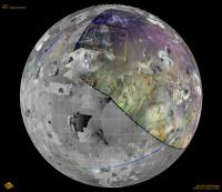
Jupiter shine map, with and without 3x3 median smoothing
|
|
For those who need it, this map is in simple cylindrical projection, lat range is -90 to 90 and so is the longitude range. Pixel scale is 2 km/pixel
Posted by: chlegrand Jan 2 2024, 06:40 AM
Hello UMSF members,
I follow everyday all your exchanges about lunar and planetary missions.
I'm one of the co-authors of the "Virtual Moon Atlas" (VMA) and "Virtual Planets Atlas" (VPA) freewares.
https://ap-i.net/avl/en/start
https://ap-i.net/avp/en/start
Our goal is to provide for general public and scientists, easy to use basic tools for improving lunar and planetary knowledge.
As you will see if you download and try it, VPA presents telluric planets and Galileo satellites real time maps. For that, we use with permission equirectangular "textures" in the 2:1 ratio buit from various planets maps found on the Internet and publically available.
I would like to add in VPA Juno's maps of the Galileo satellites since presently, there are only Voyagers and Galileo maps used in the freeware.
Using the VPA "double window" functionnality, it will certainly be useful to look for planetary surface evolutions between these various missions for VPA users.
Does anyone could help us and provide such best resolution equirectangular Juno maps for Io (Sure !) but also for Europa and Ganymede that can be used in VPA with permission and thanks ? (Natural or enhanced colors / B&W / 2:1 ratio / jpg format / 4000x2000 pixels minimum or more)
Thank you in advance for your support to our action if you agree.
Ch. Legrand
PS : Sorry for my rather poor english
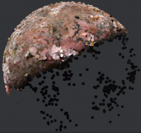
Posted by: kymani76 Jan 2 2024, 11:44 AM
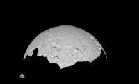
|
I managed to extract preliminary shape model of Io from all the imagery. It might be possible to refine it further,
but I encountered some hardware limitation with processing, which need more time to resolve.

|
The tall Matterhorn-like mountain really stands out.
Model is available for download by clicking https://www.dropbox.com/scl/fi/tdfou3cosdmdqwljq5rgb/io_juno_v1.obj?rlkey=i6nv2zpg98qinvjbcphqlpce6&dl=0.
Posted by: Decepticon Jan 2 2024, 05:50 PM
The nightside image is a wonderful bonus!
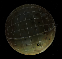
Posted by: kymani76 Jan 2 2024, 10:51 PM
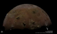
|
I refined Io shape model further with more images and added texture overlay.
The mountains are not as prominent as I thought they whey would be, as stereo information is not sufficiently dense.
The resulting DEM is consequently also of low resolution. The model would benefit from the entire sequence of images
from the same hand.
|
I can also get some cloud points for the nightside (image above), but would need more imagery to model it.
You can download the new model https://sketchfab.com/3d-models/io-juno-pj57-shape-model-768ccaae9b2f4d598dc94e36db32ea32.
Posted by: mcaplinger Jan 3 2024, 02:39 AM
The Jupiter images have been posted to missionjuno. I think we're still waiting on some partials for the approach images, some which are pretty neat (GRS with a distance Io).
Posted by: Decepticon Jan 3 2024, 05:22 AM
Does the next flyby cover the same region?
Posted by: mcaplinger Jan 3 2024, 05:55 AM
It's more equatorial but the same hemisphere.
|
Posted by: chlegrand Jan 3 2024, 06:56 AM
Hello UMSF members,
Here are my first attempts for introducing Volcanopele work in VPA freeware.
Screen captures are :
PJ 57 et PJ 55 comparison showing resolution increase
PJ57 & Voyager-Galileo texture
PJ57 & Voyager-Galileo texture annotated
PJ57 & Voyager-Galileo texture close-up
Hope that this will be helpful to everyone
Sincerely yours
Ch. Legrand


Posted by: StargazeInWonder Jan 3 2024, 05:22 PM
Fortunately, the next flyby covers almost exactly the opposite side of Io. If that is successful, with comparable jupitershine imagery, we could come away with about as close as possible to global coverage with just two flybys.
Posted by: Brian Swift Jan 4 2024, 07:35 AM
I assume the two SAMPLING_FACTOR": 2 images were included just to mess with us. ;-)
Posted by: volcanopele Jan 4 2024, 04:06 PM
Mike, I am definitely coming around to the idea that if you can get well exposed Jupiter-shine images in the green filter, being able to stack them to improve SNR and getting more of them would be fine. While RED has the best SNR, GREEN has the best balance of SNR and albedo information.
Posted by: mcaplinger Jan 4 2024, 04:46 PM
Are you sure? The outbound sub-spacecraft point was about 40N,30E for PJ57 and it's about 0N,15E for PJ58. The inbound imaging on PJ58 is pretty poor resolution while the illuminated limb is still in the Junocam FOV.
Posted by: volcanopele Jan 4 2024, 05:09 PM
maybe they meant the area covered in Jupiter-shine? Because it would be fairly complimentary to the PJ57 coverage, getting more of the southern hemisphere coverage compared to the northern hemisphere coverage of PJ57. I'm looking forward to seeing East Kanehekili (-18/24) at visible wavelengths, as an example.
Posted by: StargazeInWonder Jan 4 2024, 06:07 PM
I'll defer fully on the question of which flybys offer which coverage since my visual interpretation of Jason's map was my only source, and leave that topic both to better informed people and the new threads.
Posted by: Bjorn Jonsson Jan 5 2024, 01:36 AM
ImagePJ57_23:
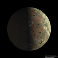
|
North is up. The brightness of the nightside has been increased to show details there.
By the way, I have noticed that the spacecraft's distance from Io as determined from the SPK kernels isn't totally accurate and this must be corrected. This is not unexpected and was also the case when processing images from the Ganymede and Europa flybys. The error is small but depending on the software used, artifacts may show up in the processed images if this is not corrected (and the START_TIME must also be corrected). The most common artifact seems to be a 'truncated' limb, I have noticed this in several processed images I have seen, in particular PJ57_22. I think ISIS3 does this (I remember also seeing this in a few Jupiter images processed using ISIS3) and my processing pipeline also does this on occasions if the geometry/time is very inaccurate. One example I saw is Kevin's otherwise excellent PJ57_22 image (IIRC he's using ISIS3) - clearly some care has to be taken when using ISIS3 to process the JunoCam images, also these artifacts aren't always obvious.
Posted by: volcanopele Jan 5 2024, 02:11 AM
For my images, I did have to set jigsaw to correct for spacecraft position to get the limb in the right spot. Plus I had to add many tie points near the limb of 57_22 to avoid color fringing. But given that we only have the predict SPK available, yeah this makes sense.
Posted by: Kevin Gill Jan 5 2024, 08:05 PM
A couple attempts at the Jupiter images, all processed with my Rust pipeline (I did my Io stuff with my ISIS+Blender method).
https://flic.kr/p/2pqGDVd
https://flic.kr/p/2pqGDVd
https://flic.kr/p/2pqK3rv
https://flic.kr/p/2pqK3rv
https://flic.kr/p/2pqKHmD
https://flic.kr/p/2pqKHmD
Posted by: Phil Stooke Jan 5 2024, 10:51 PM
So the closest images... were they lost or just degraded to they point they cannot be used? Or was imaging at closest approach not feasible?
Phil
Posted by: mcaplinger Jan 5 2024, 11:12 PM
Closest to what? Io? Io C/A was over the nightside and we didn't try to take any images.
Posted by: Phil Stooke Jan 6 2024, 12:57 AM
That answers my question - imaging at closest approach was not feasible, it was over the night side.
Phil
Posted by: scalbers Jan 6 2024, 08:51 PM
Here's a try with the GIMP-GEGL noise filter on one of volcanopele's images, brightened to show the night side. Noise setting is 10 and brightness is +6 f/stops.
|
And indeed the geometry was quite interesting to deduce in terms of corrections to what was seen in Jason's preview video. Here is how I had gridded a couple of the images with assumed values of sub-point lat/lon and distance.
|
|
Posted by: scalbers Jan 8 2024, 01:24 AM
Present version of 4K map with both daytime and nighttime regions from the post #90 Juno images. These were additionally processed and added to a prior map.
|
EDIT: The nighttime region is using just the brightness information blended with the color from the prior map. This suggests the strategy of taking only green channel images at the next flyby can work pretty well.
Posted by: scalbers Jan 8 2024, 01:33 AM
A blinking comparison of the new and prior maps:

|
Posted by: OWW Jan 8 2024, 02:30 PM
Phil
The SRU image was on the night side, but it hasn't been released yet I think. The Ganymede and Europa SRU images were released pretty quickly after the flyby, but maybe it didn't work at Io this time?
Posted by: Kevin Gill Jan 8 2024, 04:26 PM
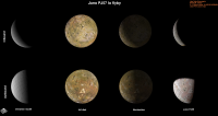
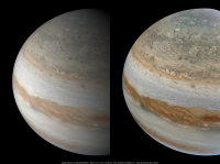
Family Portrait: Ganymede, Io, Europa, Callisto, and Jupiter. The right three moons and Jupiter are from PJ57-21, however Ganymede was just out of frame to the left. Ganymede last appeared in PJ57-12, so I grabbed it from that and composited it into the approximate location as it would have appeared. The moons have been brightened for visibility.
On a side note, that GRS is looking pretty small...
https://flic.kr/p/2prk2eM
https://flic.kr/p/2prk2eM
Posted by: Antdoghalo Jan 24 2024, 02:36 PM
Any update on the jupitershine SRU image?
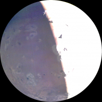
Posted by: Bjorn Jonsson Feb 3 2024, 11:23 PM
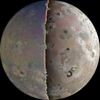
An approximately true color/contrast version (left) of image PJ57_50 and an enhanced version (right):
|
Posted by: kymani76 Feb 20 2024, 09:55 AM
|
Prediction map for where the two SRU1 images will be located should/when they appear. Calculated form SPK.
Also shown Galileo's high resolution imagery.
Posted by: volcanopele Feb 20 2024, 02:58 PM
Can you do a plot where the SRU image is one rotation later for PJ57? The one you have plotted would be too far west and right on the terminator for Jupiter-shine. I would think that the SRU image is either the rotation after that one or two rotations, though I personally really hope that it is one rotation to get all of Tonatiuh.
Posted by: kymani76 Feb 20 2024, 06:03 PM
|
|
Here is the plot as requested. One with your PJ57 map overlaid. I haven't thought about where jupitershine ends when selecting the frame.
It was a tossup which frame to select in the first place, so the new map shows all possibilities.
The footprints as shape files:
 io_JNO_SRU.zip ( 2.88K )
: 93
io_JNO_SRU.zip ( 2.88K )
: 93Any chance of PJ58 map update?

Posted by: Julius Sep 23 2024, 03:52 PM
Seeing the pictures of Io from Voyager, Galileo and now Juno, the colour of the surface seems to differ, the Voyager ones seem to picture Io as being very orange, Galileo less orangy and Juno pinkish ? Which colour is the most accurate?
Posted by: stevesliva Sep 23 2024, 05:16 PM
Some prior discussion of that here:
http://www.unmannedspaceflight.com/index.php?showtopic=4059
Posted by: volcanopele Sep 25 2024, 04:38 PM
PDS release for PJs 57 and 58 was officially yesterday. Pretty much everything is available now except for SRU oddly. Not sure if there was an issue with the instrument or issue with the release. EDIT: the PDS Imaging site has this to say: "SRU data is temporarily delayed" So it looks like they will be released just not yet.
But yeah, the data for all the other instruments is now available. I've been working with the JIRAM data for a few days now and it is going pretty well. They got quite a few postage stamps across the surface and they are of pretty good quality.

|
Instrument: Juno/JIRAM
Lat/Lon: 43 N/355.7 W
JIRAM Time: 12/30/2023 08:37:19
JNC Time: 12/30/2023 08:37:45
Resolution: 597 m/pixel

|
Comparison between Voyager ISS and JIRAM. JIRAM data inverted in brightness to make it easier to compare the two data sets. Lots of islands are consistent between the two.
Posted by: Antdoghalo Sep 25 2024, 09:22 PM
Of ALL things, it was the instrument I needed to be released!
Powered by Invision Power Board (http://www.invisionboard.com)
© Invision Power Services (http://www.invisionpower.com)