Printable Version of Topic
Click here to view this topic in its original format
Unmanned Spaceflight.com _ OSIRIS-REx _ Asteroid approach
Posted by: Holder of the Two Leashes Aug 24 2018, 06:48 PM
NASA update on the OSIRIS-REx mission, includes first picture of the asteroid from the spacecraft.
https://www.nasa.gov/feature/goddard/2018/nasas-osiris-rex-begins-asteroid-operations-campaign
Posted by: B Bernatchez Oct 6 2018, 10:33 PM
First Approach Maneuver completed:
https://www.asteroidmission.org/?latest-news=nasas-osiris-rex-executes-first-asteroid-approach-maneuver
Posted by: Explorer1 Oct 19 2018, 02:12 PM
New images! (they will be leaving the '8-bit' phase pretty soon)
https://www.asteroidmission.org/bennu-oct-2018-pixel-zoom/
Posted by: mcaplinger Oct 19 2018, 04:16 PM

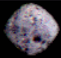
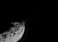
When I first read this I assumed that there was an error in the captions: at a little under 10,000 km range Bennu is only 3.7 pixels in Polycam? But it's true, and that just goes to show how dinky Bennu is. Polycam's IFOV is 13.5 urad so at range R Bennu (246 meters mean radius) subtends 0.246*2/(R*13.5e-6) pixels.
Posted by: Explorer1 Oct 24 2018, 08:03 PM
https://www.asteroidmission.org/bennu-jupiterosirisrexobservations/
New image, plus a comparison with the Jupiter observation from last year to illustrate the albedo difference. Seems like another Ryugu so far....
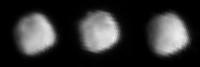
Posted by: Hungry4info Oct 26 2018, 01:18 AM
New rotation movie from 3000 km taken on 23 Oct 2018. We can see surface features, even if it's not clear exactly what they are.
https://www.asteroidmission.org/bennu-13px/
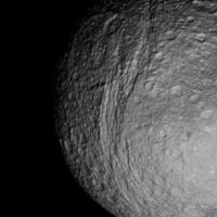
Posted by: Phil Stooke Oct 26 2018, 05:37 AM
These are the 3 frames in that short movie, a bit processed. One suggests a crater, maybe bigger (relatively) than any on Ryugu.
Phil
|
Posted by: mcmcmc Oct 29 2018, 01:39 PM
Countdowns:
https://programmi.000webhostapp.com/osiris/osiris-counter.html
They are based on odd data: "future telemetries" available as "http://www.asteroidmission.org/wp-content/uploads/2018/10/, which always says 00:00 is the time of the maneuvers, and http://www.asteroidmission.org/wp-content/uploads/2018/10/SPP-Approach-Poster-10-03-18.pdf, I don't know where to find better data.
Posted by: mcmcmc Oct 29 2018, 02:39 PM
Found more rich but less embellished countdowns:
http://www.whereisroadster.com/osiris_rex/
Posted by: Paolo Oct 30 2018, 07:41 PM
https://www.asteroidmission.org/20181029t1019ut_bennu/
looking a lot like Ryugu
Posted by: Phil Stooke Oct 30 2018, 09:43 PM
One very good thing about this is that I can use exactly the same map projection for Bennu as I used for Ryugu. Only the scale has to change.
Phil
Posted by: mcmcmc Oct 31 2018, 01:44 PM
These direct query links to NASA Horizons provide objects distance from the Sun in km:
https://ssd.jpl.nasa.gov/horizons_batch.cgi?batch=1&CENTER=%20%27500@0%27&MAKE_EPHEM=%20%27YES%27&TABLE_TYPE=%20%27VECTORS%27&STEP_SIZE=%20%271%20m%27&OUT_UNITS=%20%27KM-S%27&REF_PLANE=%20%27ECLIPTIC%27&REF_SYSTEM=%20%27J2000%27&VECT_CORR=%20%27NONE%27&VEC_LABELS=%20%27YES%27&VEC_DELTA_T=%20%27NO%27&CSV_FORMAT=%20%27YES%27&OBJ_DATA=%20%27NO%27&VEC_TABLE=%20%276%27&START_TIME='2018-10-31%2014:40'&STOP_TIME='2018-10-31%2014:41'&COMMAND='-64'
https://ssd.jpl.nasa.gov/horizons_batch.cgi?batch=1&CENTER=%20%27500@0%27&MAKE_EPHEM=%20%27YES%27&TABLE_TYPE=%20%27VECTORS%27&STEP_SIZE=%20%271%20m%27&OUT_UNITS=%20%27KM-S%27&REF_PLANE=%20%27ECLIPTIC%27&REF_SYSTEM=%20%27J2000%27&VECT_CORR=%20%27NONE%27&VEC_LABELS=%20%27YES%27&VEC_DELTA_T=%20%27NO%27&CSV_FORMAT=%20%27YES%27&OBJ_DATA=%20%27NO%27&VEC_TABLE=%20%276%27&START_TIME='2018-10-31%2014:40'&STOP_TIME='2018-10-31%2014:41'&COMMAND='1999%20RQ36'
Look for "$$SOE" in result; distance in km is value 3 counting from 0.
Resulting current distance between OSIRIS-Rex and Bennu:
2018-Oct-31 14:40 - 236.16 km
It looks quite precise despite the big distance: this method gives 7 km as Hayabusa2-Ryugu distance, which is https://programmi.000webhostapp.com/hayabusa2/simulator/haya2-dates-5000.html.
I think the distance is based on light travel time.
Posted by: mcaplinger Oct 31 2018, 04:09 PM
There are SPICE kernels for Orex at https://naif.jpl.nasa.gov/pub/naif/ORX/kernels/ -- AFAIK this is what the flight team is using.
Posted by: mcmcmc Oct 31 2018, 04:58 PM
I have no idea of what SPICE kernels are.

Posted by: mcaplinger Oct 31 2018, 08:44 PM
They are files that capture the position and orientation of spacecraft and solar system bodies, used for mission planning and data analysis. https://naif.jpl.nasa.gov/naif/aboutspice.html
If NASA Horizons does what you want, then by all means use it. I'm not certain how frequently it's updated, however.
Posted by: mcmcmc Nov 1 2018, 04:21 PM
If NASA Horizons does what you want, then by all means use it. I'm not certain how frequently it's updated, however.
It's not clear to me how these data about spacecrafts are produced; are they recorded data up to current date and calculated data from now on? i.e. are they daily updated? or just calculated from mission schedules? OSIRIS data clearly show the trajectory correction maneuvers occurred during last months, but Hayabusa data show almost constant distance 7000m from Ryugu for same period, which is not true because Hayabusa actually passed from 20.000 to 20m and the other way round several times.
Posted by: djellison Nov 1 2018, 05:34 PM
Yes. All of the above. Sometimes they are reconstructed. Sometimes they are predicted. Sometimes updated very regularly. Sometimes not. Metadata is usually included to explain the source of the data used.
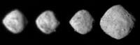
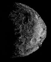
Posted by: Phil Stooke Nov 2 2018, 08:07 PM
An approach GIF was just released - these are the 4 best frames, rescaled. The surface is becoming clearer.
Phil
|
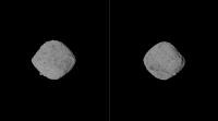
Posted by: Hungry4info Nov 6 2018, 01:22 AM
https://www.asteroidmission.org/bennu-at-160-and-200-px/
|
Posted by: Explorer1 Nov 6 2018, 03:46 AM
Interesting dark patches in the southern hemisphere on the right image, and what might be a crater on the far right limb?
EDIT: rotation movie out! I'll leave it to the experts.... https://www.asteroidmission.org/bennu-rotation_20181102/
Posted by: charborob Nov 6 2018, 09:09 PM
https://www.asteroidmission.org/bennu-rotation_20181102/
Posted by: Phil Stooke Nov 7 2018, 12:10 AM
Beautiful! That should be enough for a preliminary shape model and map.
Phil
Posted by: mcmcmc Nov 7 2018, 11:13 AM
Phil
Shape model (just look, don't touch :-( ):
https://twitter.com/3Dmattias/status/1059936642612502529
Posted by: walfy Nov 8 2018, 06:05 AM
Here's a quickly rotating GIF in 3D of it, with contrast boost. Will post a slower next.
|
Posted by: walfy Nov 8 2018, 06:11 AM
This version spins much slower, at 3 second intervals, less jarring on the eyes:

|
Posted by: Phil Stooke Nov 8 2018, 07:33 AM
Nice! And another way of presenting the data in the animation, a set of frames. The last one is a repeat of the first one. A bit of a contrast stretch was applied.
Phil
|
Posted by: Roman Tkachenko Nov 9 2018, 01:17 PM
Asteroid Bennu Rotation (3D animation)

Posted by: mcmcmc Nov 12 2018, 09:15 PM
Interactive video:
http://win98.altervista.org/space/exploration/osiris/player/rotation.html
(allow several seconds until all 250 frames load).
Updated monitoring page:
http://win98.altervista.org/space/exploration
Posted by: charborob Nov 23 2018, 07:53 PM
https://www.asteroidmission.org/bennu-at-300-px/
Posted by: Spock1108 Nov 24 2018, 09:07 AM
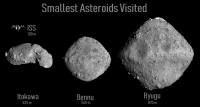
Bennu is really very small compared to Ryugu, it's as big as Itokawa ... but why doesn't Itokwa have the same shape?
|
Posted by: Holder of the Two Leashes Nov 30 2018, 05:17 PM
I guess the best word I can think of here is "ironic".
Hayabusa 2 was planned with three sample acquisitions in mind, with the idea of getting diverse samples. But Ryugu turned out to appear fairly homogeneous so now they are only planning one sample (what about the sub surface sampling though? But I digress... ).
Then you have OSIRIS-REx only planning one single sample grab from Bennu.
I know they haven't reported anything yet about any of Bennu's compositional differences but, well... just look at it.
Technically, they could make three tries at sampling, provided the canister didn't fill up on the first try, so I wonder if they might rethink things.
Also, I'm a little worried at this point. OSIRIS-REx seems to be counting on there being dust and small pebbles for its sampling. It is still too far from Bennu to tell, but if the surface turns out to be like Ryugu with nothing but larger pebbles and rocks available, I wonder how they will deal with that.
Posted by: tanjent Nov 30 2018, 07:08 PM
That's a nice side-by side comparison of the three bodies, and it is consistent with the unexpectedly rocky surface of Ryuku and likely Bennu too.
Isn't that how panning for gold works? If you put heterogeneous gravel in a pan and agitate it, the smaller particles will settle to the bottom and the larger chunks will "float" to the top, even if they are intrinsically denser, because their irregular shapes prevent them from packing together as tightly. So in a rubble pile asteroid, the finer material will tend to migrate to the center. Itokawa probably had a bit more structural rigidity than the other two, at least enough to prevent this sorting process from proceeding quite so far.
The similar slightly oblate shapes of Ryugu and Bennu seem to reflect a balance between centrifugal force and their minimal gravity which may prove to be the norm for very loosely accreted piles of variously-sized junk.
If so, it may well complicate the sample collection process as Holder suggests.
Posted by: Adam Hurcewicz Dec 2 2018, 01:05 PM
OSIRIS-REx Arrival to Bennu (3-18 Dec 2018)
https://www.youtube.com/watch?v=Yrc4jR3Gy5M
I use SPICE (bsp,bc,tsc,tpc,tf) files from NAIF/NASA
Model of OREX is from NASA 3D models converted to cmod.
Soft is Celestia 1.7 64bit
More info apout arrival :
https://www.asteroidmission.org/asteroid-operations/
|
Posted by: Daniele_bianchino_Italy Dec 3 2018, 11:30 AM
I allowed myself to revisit Emily's comparison (Itokawa + Ryugu) and add asteroid Bennu: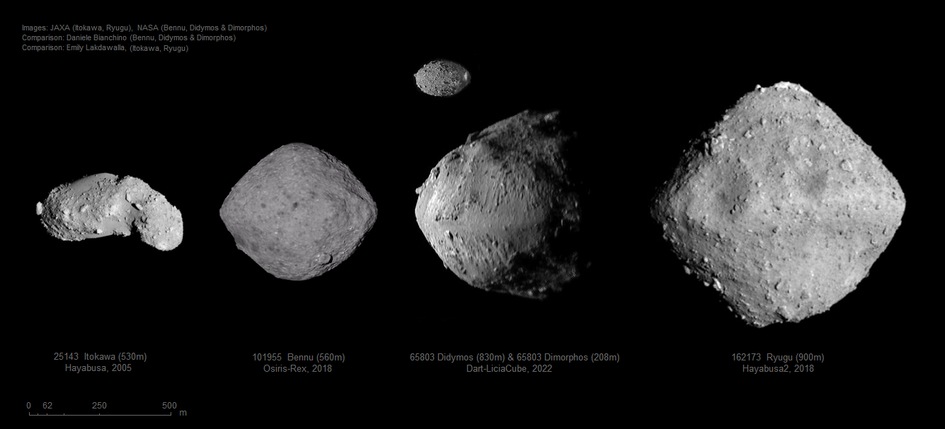
Posted by: PhilipTerryGraham Dec 3 2018, 05:55 PM

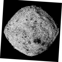
This is what I'm assuming to be new, higher-resolution MapCam imagery. This GIF is featured on the mission's front page and the "spacecraft imagery" page, but clicking on the link (https://www.asteroidmission.org/?attachment_id=12095#main) leads to a 404... Anyways, many congratulations to the OSIRIS-REx team for completing the long journey to Bennu! I wish nothing but the very best for the mission ahead!
Posted by: Holder of the Two Leashes Dec 3 2018, 07:08 PM
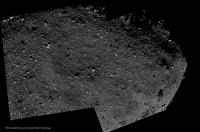
At the OSIRIS-REx website, the caption for the above image sequence reads as follows:
Date Taken: Nov. 25, 2018
Instrument Used: OCAMS (PolyCam)
Credits: NASA's Goddard Space Flight Center/University of Arizona
Congratulations to the spacecraft team for a successful arrival today!
Posted by: vjkane Dec 3 2018, 08:31 PM
I suspect it may take a lot of careful planning to find a safe touchdown surface on that asteroid.
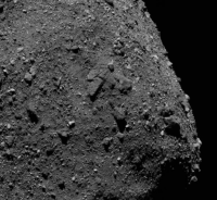
Posted by: ElkGroveDan Dec 3 2018, 08:54 PM
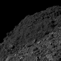
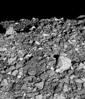
The first thing that stands out is how unusually sharp and angular the surface debris appears.
Posted by: Y Bar Ranch Dec 4 2018, 02:33 AM
The animation makes it look like boulders should be flying off of it left and right. 
It'd be interesting to run a "Project Crowbar" to lever off one of the bigger boulders and drag/toss it into orbit for a full grapple and analysis.
Posted by: elakdawalla Dec 4 2018, 06:17 AM
I pride myself on being able to discern solar system worlds, but if it were not for Ryugu's special polar boulder and Bennu's "pimple" boulder I would not be able to tell the two apart without consulting reference images.
Posted by: Hungry4info Dec 5 2018, 12:33 AM
One thing that will help will be that the camera views aren't going to be constantly at full phase.
Here's Bennu at half phase from MapCam.
https://www.asteroidmission.org/20181203_mapcam/
Posted by: nprev Dec 5 2018, 03:13 AM
Sure is a jagged little beast. Makes me wonder if the regolith is relatively fresh with less thermal & micrometeoritic weathering than we've seen on other comparable bodies.
Posted by: HSchirmer Dec 5 2018, 04:03 AM
Isn't that how panning for gold works? If you put heterogeneous gravel in a pan and agitate it, the smaller particles will settle to the bottom and the larger chunks will "float" to the top, even if they are intrinsically denser, because their irregular shapes prevent them from packing together as tightly.
Actually, what you're describing is "the Brasil Nut Effect" and there's even a paper on this
"The spherical Brazil Nut Effect and its significance to asteroids" https://academic.oup.com/mnras/article-pdf/443/4/3368/6291556/stu1388.pdf
Panning for gold is kinda the opposite, based on bulk density rather than grain size. Since gold is denser than stone, it is retained in the pan, or settles out into the grooves of a sluice, or if you're really old-school, settles out in the wool of a sheepskin...
Posted by: Holder of the Two Leashes Dec 5 2018, 05:47 PM
https://www.asteroidmission.org/20181203_mapcam/ taken seven hours before arrival by MapCam (click on link).
There will be a press conference December 10th to discuss the initial scientific results from approach, along with presentations at the AGU (American Geophysical Union) meeting on the 11th and 12th.
https://www.asteroidmission.org/osiris-rex-agu-2018/
Posted by: Steve5304 Dec 7 2018, 01:05 PM
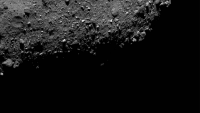
The thing on the bottom left looks like a flat curled up sheet

Its probably an optical illusion but man this thing has definitely collected a lot of rocky stuff over the years. Much different than Ryugu
Full Rotation
https://www.asteroidmission.org/?attachment_id=12182#main
Posted by: Holder of the Two Leashes Dec 10 2018, 06:45 PM
News conference ready to start in fifteen minutes. (2pm EST December 10th)
http://live.projectionnet.com/AGUPress/FM2018.aspx
Posted by: pbanholzer Dec 11 2018, 02:24 AM
http://live.projectionnet.com/AGUPress/FM2018.aspx
The AGU link has expired but it is available on Youtube https://www.youtube.com/watch?v=WRCzK8uZvoY
Posted by: elakdawalla Dec 11 2018, 06:46 PM
Here are a few images from the https://fallmeeting.agu.org/2018/files/2018/12/AGU-Press-Event_HR-Revision_FINAL_SMALL_SIZE.pdf, including a color MapCam portrait. If you break the MapCam view down into its channels, you can see that they didn't reproject the images before combining them into an RGB product -- there's evident rotation of the asteroid between red, green, and blue channels. They're also massively stretched. Can any of you image processing sorcerers do a better job with the image processing and maybe create a nice color portrait of Bennu?
|
|
|
|
Posted by: elakdawalla Dec 11 2018, 06:58 PM
This is the best I can do -- please someone here do better than me so I don't have to post this garbage on my website 
|
Posted by: Ian R Dec 12 2018, 12:18 AM
Here's a mediocre effort of my own, Emily 
|
Posted by: charborob Dec 22 2018, 08:03 PM
https://www.asteroidmission.org/bennunorthpolepassdec4/.
Posted by: kenny Jan 1 2019, 12:17 PM
OSIRIS-REx has successfully entered orbit around Bennu.
It is orbiting a mere 1 mile (1.75km) from the centre of the asteroid !
More details here...
https://solarsystem.nasa.gov/news/805/nasas-osiris-rex-spacecraft-enters-close-orbit-around-bennu-breaking-record/
Happy New Year to all, and looking forward to an extraordinary few days in solar system exploration...
Posted by: MarkG Jan 1 2019, 10:18 PM
[quote ...It is orbiting a mere 1 mile (1.75km) from the centre of the asteroid !
[/quote]
I believe the orbital period is 62 hours, which makes the orbital velocity about 3 meters/minute, 50mm/sec. (10ʻ/min, 2"sec).
Posted by: Marcin600 Jan 23 2019, 12:11 AM
New image - Bennu’s south pole: https://www.asteroidmission.org/mapcam-south-pole-flyby-20181217t061345/
I see a nice little crater with a flat bottom and a typical (?) grouping of large boulders in the pole region
|
Posted by: Explorer1 Feb 28 2019, 04:45 AM
Very nice high-res view near the north pole: https://www.asteroidmission.org/mapcam-north-pole-20190220/
Posted by: Marcin600 Mar 14 2019, 09:55 PM
New pics - region of Bennu’s northern hemisphere close up: https://www.asteroidmission.org/2019-02-25-regolith-image-compilation-3/
with: "pond” of regolith that is mostly devoid of large rocks" and "15 meter boulder"
Posted by: Hungry4info Mar 19 2019, 07:24 PM
Bennu has plumes! (or perhaps rather ejections of material)
The OSIRIS-REx team initially spotted the particle plumes in images while the spacecraft was orbiting Bennu at a distance of about one mile (1.61 kilometers). Following a safety assessment, the mission team concluded the particles did not pose a risk to the spacecraft. The team continues to analyze the particle plumes and their possible causes.
https://solarsystem.nasa.gov/news/877/nasa-mission-reveals-asteroid-has-big-surprises/
|
More images:
https://svs.gsfc.nasa.gov/13154
Posted by: Explorer1 Mar 20 2019, 03:37 AM
So Bennu apparently has temporary moons every once in a while. I wonder if the spacecraft could get close to one of the larger ones to resolve it. Hopefully the team is confident these events won't be too big a deal and they can narrow the site they occur (I wouldn't want one nearby during sample collection!).
Posted by: PhilipTerryGraham Mar 20 2019, 05:42 AM
So we've uncovered a contact binary KBO that's really flat, and a Near-Earth asteroid that's spewing rocks into its orbit. What other weeeird stuff is 2019 gonna give to us, I wonder? On topic though, has the OSIRIS-REx team been able to locate where the sources of these ejections are on Bennu? I anticipate that'll be a new priority.
Posted by: nprev Mar 20 2019, 06:30 AM
Hard to think of anything that would cause this aside from straight-up thermal expansion. Pockets of volatiles sublimating would presumably produce far more energetic (and dense, and visible) plumes.
Maybe it does something similar at aphelion when contraction happens, or maybe that's just how the mechanical energy gets 'loaded' for perihelion passage burps like these. Still...without any significant surface gravitation that's not gonna cause much compression of surface materials at all.
Regardless: Cool. That's why we're here. 
Posted by: stevesliva Mar 20 2019, 02:06 PM
You mention thermal and mechanical/gravity. There's also electrostatic...
Posted by: Gerald Mar 20 2019, 02:09 PM
Agreed, https://agupubs.onlinelibrary.wiley.com/doi/pdf/10.1002/2015JA021738 may do it, as well. Even a weak repulsive force would be sufficient. I think, that 10V are considered reasonable in direct sunlight. Impacts of micrometeorites might be another approach. Tracking particles, and their acceleration due to solar radiation pressure and some potential weak electrostatic field could clarify the physics at work. Those fields would change with solar irradiation.
Posted by: Marcin600 Mar 20 2019, 07:11 PM
Or maybe Bennu is a body reassembled from fragments scattered after a relatively recent breakdown by impact and it is still undergoing a rearrangement of its surface (creation of the equatorial ridge) under the influence of its own gravity. Such small surface movements could throw small particles into space (?)
Posted by: bsharp Mar 21 2019, 12:56 PM
Image processing artifacts or a lot more particles orbiting around Bennu?
Cranked up brightness levels in original image https://www.asteroidmission.org/?attachment_id=15595

|
|
Posted by: fredk Mar 21 2019, 03:14 PM
Recall that that press release image was a composite of two frames, differing by a factor of a few thousand in shutter speed. So if you're referring to the arc of bright pixels reaching clockwise around Bennu from the main "jet", the sharpness of that arc's inner edge suggests that edge is the splice between the two frames. Since the outer exposure was much longer, it was probably picking up some glare from the main asteroid's body, which appeared as a sprinkling of bright pixels.
The main "jet" would appear much, much fainter (or be invisible) if this was a single exposure.
Posted by: bsharp Mar 21 2019, 06:17 PM
Thx, yes, I guessed just as much. The other composite (posted here yesterday) shows the glare and the thorough identification process by the team, this wouldn't have escaped them. "Jet" particle sizes were said to be cm size, even as much as 30cm.
Posted by: tolis Mar 21 2019, 08:04 PM
if memory serves, the charge-to-mass ratio of cm-sized particles would be far too low for electrostatic forces to play a role. This is some combination of day-to night thermal cycling + rotational state + composition.
Posted by: Roman Tkachenko Mar 27 2019, 05:41 PM
This 3D visualization is based on my preliminary 3D shape model and data taken by NASA's OSIRIS-REx spacecraft.
https://youtu.be/QRWdBoQm7J0
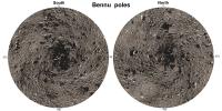
Posted by: Phil Stooke Mar 27 2019, 07:11 PM
Very nice!.
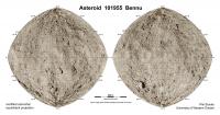
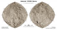
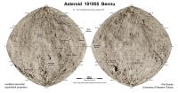
Here is a map of Bennu. The main part of the surface is derived from a map on the mission website which extends from 70 N to 70 S. I had to fudge the poles (as we cartographers say) from other images. A couple of rocks have informal names (The Gargoyle is one of them), which I will add when I figure out where they are. If anyone knows of any other informal names let me know.
The map projection is the same as I used for the Ryugu map, as they are so similar in shape.
Phil
|
Posted by: elakdawalla Mar 27 2019, 08:46 PM
Nice map! I believe that the rock at 45S 130E is "Ben-Ben." https://twitter.com/elakdawalla/status/1079919898514485248
Posted by: charborob Mar 27 2019, 10:09 PM
https://www.asteroidmission.org/bennus-boulder-1-stereo-pair-cross-eyed-version/
Posted by: Marcin600 Apr 7 2019, 05:04 PM
New pictures on the OSIRIS-REx website:
Bennu’s Equatorial Ridge - https://www.asteroidmission.org/20190329-fb4-equator-view/,
Global Mosaic with a coordinate grid - https://www.asteroidmission.org/bennu-sides-and-global-mosaic/ ,
3D view from Laser Altimeter (OLA) measurements - https://www.asteroidmission.org/bennu-visualized-by-ola-large/
and collection of 7 Nature papers (free and with many interesting pictures and conclusions) - https://www.asteroidmission.org/?latest-news=osiris-rex-special-collection-nature
|
Posted by: Marcin600 Apr 7 2019, 07:22 PM
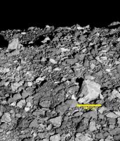
Two Bennu's pictures ( https://www.asteroidmission.org/20190329-fb4-equator-view/ and https://www.asteroidmission.org/?attachment_id=15551#main), turned, cropped and brightened (as Bennu is very dark) - give a bit of sense of view from above the surface
I added a scale
For future astronauts, the terrain would be difficult to move around (large boulders everywhere), and microgravity would probably not help walking (constant danger of "flying away" into space)
I think it would be a bit like trying to walk on the bottom of the sea with an oxygen bottle on your back. This would require lengthy practice. And no one, even a large rock, gives support, because it can "fly away" with you. Anyway, big boulders, carelessly pushed too much and fluttering around your head is quite scary vision.
|
|
|
|
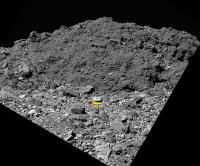
Posted by: Marcin600 Apr 11 2019, 10:21 PM
Interesting photos from OSIRIS-REx:
really huge boulder in the northern hemisphere - https://www.asteroidmission.org/20190307-polycam-northern-boulder/
cracked boulders on the equator - https://www.asteroidmission.org/20190307-polycam-cracked-rock/
I changed the first one slightly
|
Posted by: Marcin600 Apr 12 2019, 07:47 PM
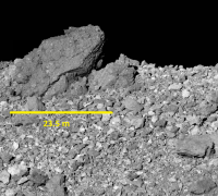
More beautiful boulders: https://www.asteroidmission.org/20190307-southern-boulder-region/
(I love big boulders in small worlds  )
)
Many meteor collectors (including me) would like to have such "pebble" - it is CM chondrite, like Murchison (or something very similar)
|
Posted by: Daniele_bianchino_Italy Apr 14 2019, 09:03 AM
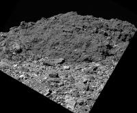
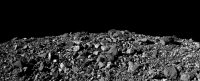
This revolutionizes a bit how I imagined the surface of asteroids forever and how we all imagined it, I think. It does not seem something anomalous or alien but something very common, any valley of terrestrial stones that is often found in the high mountains. I am trying to imagine the men in scale in these photos, exploring among those numerous rocks and I realize that there are so many that it would be difficult to walk there. So many "common" rocks let me think of the remains a part of an already existing and exploded world rather than an agglomeration formed with millions and millions of years. I probably can't conceive.
[]
Posted by: Marcin600 Apr 15 2019, 10:17 PM
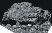
"Benben" - largest boulder on Bennu: https://www.asteroidmission.org/20190307-polycam-benben/
(I found in reliable Wikipedia: "Benben was the mound that arose from the primordial waters Nu upon which the creator deity Atum settled in the creation myth of the Heliopolitan form of ancient Egyptian religion. The Benben stone (also known as a pyramidion) is the top stone of the pyramid. It is also related to the Obelisk." - https://en.wikipedia.org/wiki/Benben
And for fun, and for scale - a brave future astronaut exploring this huge rock with pickax
|
|
Posted by: Marcin600 Apr 16 2019, 01:29 AM
[]
"So many "common" rocks let me think of the remains a part of an already existing and exploded world rather than an agglomeration formed with millions and millions of years."
In the case of Ryugu, according to http://science.sciencemag.org/content/early/2019/03/18/science.aaw0422, one of the models of its origin assumes that it (or rather its parent body) was broken into pieces by catastrophic impact and reaccumulated, at least a couple of times! Maybe the same applies to Bennu (?)

|
Posted by: AndyG Apr 16 2019, 10:36 PM
I need help here.
I can see a protoplanetary disc containing silicon and oxygen, and I can see these elements combining to make molecules that may later join together to form rock-dust-bunnies, bonded by electrostatic forces.
Here on Bennu I'm looking at consolidated rocks, alongside other 'conglomerates' that do not appear, at least at first glance, as particularly rock-like.
What is the step from dust to solid rock? Does it imply gravity (there's precious little here), heat from impacts (but, then, what keeps the dust together in such a collision?)
How does it potentially occur?
Andy
Posted by: Marcin600 Apr 16 2019, 11:26 PM
I can see a protoplanetary disc containing silicon and oxygen, and I can see these elements combining to make molecules that may later join together to form rock-dust-bunnies, bonded by electrostatic forces.
Here on Bennu I'm looking at consolidated rocks, alongside other 'conglomerates' that do not appear, at least at first glance, as particularly rock-like.
What is the step from dust to solid rock? Does it imply gravity (there's precious little here), heat from impacts (but, then, what keeps the dust together in such a collision?)
How does it potentially occur?
Andy
Remember that small rocky asteroids like Bennu or Ryugu are not substantially primordial bodies, but formed from the breakdown of much, much larger asteroids. On these larger parent bodies (primordial), gravity was much higher, impact resistance was greater and, at the beginning, there was a lot of heat from the decomposition of short-lived elements, like aluminium (aluminum
isotope Al26
Posted by: Marcin600 Apr 16 2019, 11:34 PM
As far as I know, the details of the transition "from dust to rocks" are not well known (?) and it is being investigated (and its vision changes) before our eyes! The only "truly" primordial object we have seen so far is Ultima Thule, but it has a different composition (a lot of "ice"), because it is located (and always was there) far from the Sun.
Posted by: alan Apr 17 2019, 08:44 PM
The popular model these days is that in the protoplanetary disk dust grews into pebbles, probably mm sized in the inner solar system. In some parts of the disk these be came concentrated enough by one of a variety of of mechanisms to undergo a gravitational instability which caused clumps of them to collapse into asteroids ~100km in diameter. The consolidated rocks would form in these asteroids and be broken up and scattered in later collisions.
Posted by: JRehling Apr 18 2019, 01:53 AM
My understanding, via meteorites:
Parent bodies were either differentiated (large enough to have possessed sufficient radiogenic heat to melt) or not. From those that were smaller, we have chondrites, whose solid minerals date back to the first millions of years after the origin of the solar system. Chondrites have iron in abundance along with other stone a lot like the overall composition of the Earth or Venus if you count the cores and mantles both but in the chondrites, iron and stone are mixed on a fine level.
From larger parent bodies, exemplified near the larger end by Vesta, we have achondrites. Like smaller versions of the Earth and Venus, these were large enough to melt through, and their iron descended into a core, leaving a relatively iron-poor mantle/crust. Meteorites from Vesta therefore have elemental composition approximately like the crusts of Earth or Venus.
Bennu sure looks like some interesting geology has taken place, but it is classified as carbonaceous and is thus likely a fragment of a smaller, undifferentiated parent body rather than a larger one. If so, we'll expect to find higher levels of iron when we get those samples.
http://meteorites.wustl.edu/metcomp/index_files/image002.gif
Posted by: charborob May 10 2019, 02:05 AM
Looking at the published images of Bennu (https://www.asteroidmission.org/galleries/spacecraft-imagery/), I noticed that two of them could be stitched together:
|
Posted by: Marcin600 May 14 2019, 11:46 PM
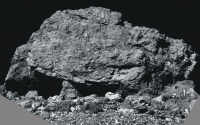
https://www.asteroidmission.org/20190329-benben-north/ (nicknamed Benben) - rotaded, brightened and with scale bar. In the third picture for scale is Apollo 12 astronaut Pete Conrad with Surveyor 3
|
|
|
Posted by: Marcin600 May 15 2019, 12:45 AM
And a bit more "free" version of https://www.asteroidmission.org/20190329-benben-north/ with Apollo 12 astronaut Pete Conrad with Surveyor 3 for scale
|
Posted by: climber May 15 2019, 08:08 PM
Why did you choose the shortest men on the Moon? 
Posted by: Marcin600 May 15 2019, 08:32 PM
Because he was most photogenic
Posted by: charborob Jul 2 2019, 03:01 PM
Two of the recently posted images of Bennu could be stitched together:
|
Posted by: Holder of the Two Leashes Aug 13 2019, 01:23 PM
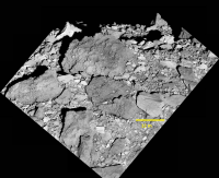
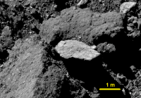
Four candidate sample sites on Bennu have been selected.
https://www.asteroidmission.org/?latest-news=nasa-mission-selects-final-four-site-candidates-asteroid-sample-return
Posted by: stevesliva Aug 13 2019, 01:59 PM
Granted it's in bold at the bottom of the release, but I almost missed it... this web-media feature has a bunch of imagery and discussion and analysis of all four sites:
https://www.asteroidmission.org/candidate-sample-sites/
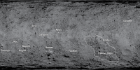
Posted by: Phil Stooke Aug 13 2019, 05:22 PM
Time to update my map.
Phil
|
Posted by: John Moore Aug 29 2019, 07:07 PM
Nice animation (and explanation) https://www.asteroidmission.org/?latest-news=flyover-candidate-sample-sites of the four possible sites (definitely do a full screen on this).
John
Posted by: Marcin600 Oct 1 2019, 01:10 AM
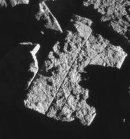
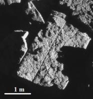
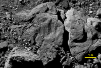
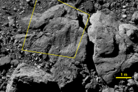
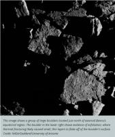
Surprisingly regular pattern of cracks on Bennu's boulder ( from https://www.asteroidmission.org/20190720largefracturedboulders/ ).
The beauty of natural physical processes common in the Universe...
|
|
Posted by: Holder of the Two Leashes Dec 12 2019, 04:51 PM
The down selection to a primary and backup sampling site could occur as early as today.
In the meantime here are a couple of article links. One is an update and another is about a close call that almost postponed the sampling a great deal.
LINK: https://phys.org/news/2019-12-nasa-osiris-rex-midst-site.html
LINK: https://phys.org/news/2019-12-osiris-rex-asteroid-mission.html !!!
Quote from the end of the second article:
Posted by: Holder of the Two Leashes Dec 13 2019, 02:25 PM
It will be Nightingale. Osprey is the backup site.
Spaceflight Now Article: https://spaceflightnow.com/2019/12/12/nasa-selects-site-for-osiris-rex-to-collect-asteroid-samples/
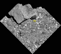
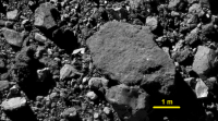
Posted by: Marcin600 Feb 1 2020, 02:00 AM
New, detailed pictures of the surface of Nightingale, taken January 22, 2020 from 600 m - on https://www.asteroidmission.org/galleries/spacecraft-imagery/ (and also nice mosaics).
Pictures: NASA/Goddard/University of Arizona, slightly changed.
|
|
|

|
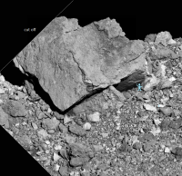
Posted by: Marcin600 Feb 6 2020, 12:04 AM
More https://www.asteroidmission.org/galleries/spacecraft-imagery/ from a 600 m (pictures from OSIRIS-REx: NASA/Goddard/University of Arizona, slightly changed)
The first one looks a bit like cracked erratic with glacial polish
|
|
|
Posted by: Marcin600 Feb 15 2020, 04:13 PM
From the OSIRIS-Rex https://www.asteroidmission.org/?latest-news=status-update-osiris-rex-osprey-flyover: "On Feb. 11, NASAs OSIRIS-REx spacecraft safely executed a 0.4-mile (620-m) flyover of the backup sample collection site Osprey... Preliminary telemetry, however, indicates that the OSIRIS-REx Laser Altimeter (OLA) did not operate as expected during the 11-hour event. The OLA instrument was scheduled to provide ranging data to the spacecrafts PolyCam imager, which would allow the camera to focus while imaging the area around the sample collection site. Consequently, the PolyCam images from the flyover are likely out of focus. The other science instruments... all performed nominally during the flyover... The mission team is currently reviewing the available data from the flyover in order to fully assess the OLA instrument..."
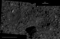
Posted by: Marcin600 Mar 7 2020, 04:52 PM
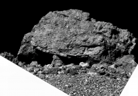
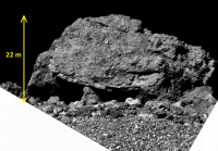
First official (approved by IAU) Bennu surface feature https://www.asteroidmission.org/?latest-news=first-official-names-given-to-features-on-asteroid-bennu: 11 boulders (Saxum) and 1 Regio.
Most prominent boulder (22 m high) is officially designated Benben Saxum.
|
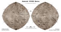
Posted by: Phil Stooke Mar 20 2020, 02:32 AM
Time to update my map! No craters are named yet but I expect we will get a few more names later. When I can get a version of the new map without text I will put it into this map.
Phil
|
Posted by: stevesliva Mar 20 2020, 02:51 AM
Google translate: saxum == stone. That's a new one to me.
I enjoy this sort of thing. Had to give my doctor wife a hard time when I discovered the posterior fossa isn't where I'd expect it to be.
Posted by: Marcin600 Mar 20 2020, 08:16 AM
This is a new category in the Solar System nomenclature. So far, "saxum's" (actually: Saxa) names https://planetarynames.wr.usgs.gov/nomenclature/SearchResults;jsessionid=43216D2C193AE5B5EBA185A642EAC75E only for Ryugu (only 3, e.g. Otohime Saxum) and Bennu (11).
PS. When I hear: "posterior fossa", I think about one of these things (I know it's Chasma - not fossa - on Tethys, but it looks good):

|
|
|
Posted by: Marcin600 Mar 20 2020, 09:24 AM
https://www.asteroidmission.org/bennu_global_mosaic/ - version without text
Posted by: Marcin600 Mar 20 2020, 09:59 AM
New, sharp and amazing resolution https://www.asteroidmission.org/20200303pebblesincrevices/ from 0.3 km
|
|
Posted by: Marcin600 Mar 20 2020, 10:04 AM
https://www.asteroidmission.org/20200303blockrock/ of surprisingly geometric shapes of boulders on Bennu

|
Posted by: Phil Stooke Mar 20 2020, 04:08 PM
Marcin600 - yes, I just noticed the mosaic has been released without names. When I can get to it I will put it in my map.
Phil
Posted by: Marcin600 Mar 20 2020, 10:13 PM
Phil
I get it (I gave the link just in case). Me and many people are waiting for your works - they are always perfect !
Marcin
Ps. Is it possible to make polar projections (maps) from the materials you have so far from OSIRIS-REx?
Posted by: Phil Stooke Mar 21 2020, 08:05 PM
Polar projections...
|
These are not full polar hemispheres, they extend from 60 degrees N and S to the pole. Later I will make versions with grids, and full polar hemispheres. These are using the new mosaic.
Phil
Posted by: Marcin600 Mar 22 2020, 04:47 AM
|
|
These are not full polar hemispheres, they extend from 60 degrees N and S to the pole. Later I will make versions with grids, and full polar hemispheres. These are using the new mosaic.
Phil
Wow! How fast!
 You're the best!
Posted by: mcaplinger Mar 25 2020, 03:52 AM
Here's some more info about Natural Feature Tracking.
https://www.nasa.gov/feature/goddard/2020/bennus-boulders-shine-as-beacons
Somehow, this blurb completely omits describing the camera being used for NFT or the organization that built it. 
As far as I can tell, the plan is still to execute the first TAG rehearsal in April.
At some point we may want a new thread.
Posted by: Phil Stooke Mar 28 2020, 09:27 PM
Here is a new map using the recently-released mission map as background.
Phil
|
Posted by: Phil Stooke Mar 31 2020, 08:57 PM
https://astrogeology.usgs.gov/news/nomenclature/twelve-new-names-approved-for-bennu
A new set of names for Bennu's rocks, added to those already given. I will get them on the map as time permits. Nice to see Thorondor among them, me being a Tolkien addict from way back.
Phil
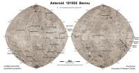
Posted by: Phil Stooke Mar 31 2020, 09:32 PM
Time permitted. New map, new names.
Phil
|
Posted by: Phil Stooke Apr 4 2020, 06:42 PM
OK, now I'm adding the locations of the three particle ejection events reported so far.
Phil
|
Posted by: chuckclark Apr 5 2020, 12:40 PM
Hmm. Three. And all in the same hemisphere. Ain't that kinda curious . . .
Three debris fields . . . hmm again:
Let's abstract the situation: Three relatively closely spaced points on a roughly spherical object make a triangle.
Now toy with it . . . connect each point with the center of its opposing side to find the triangle's centroid (where the lines intersect inside the triangle); extending those lines across [around?] the opposite hemisphere determines another point of intersection.
Use this antipodal intersection point to interrupt the surface and "unpeel" it along those extended medians a little bit——say 30 arc-degrees so we stay well distant from the debris fields——and use that extent of unpeeling-the-orange to create a Constant-Scale Natural Boundary map well suited to comprehensively study the debris fields and their interactions if any.
Alternatively, assuming no access to CSNB software, use
1) the antipodal point as the edge of an azimuthal equidistant projection to get a standard map crudely suitable for the same purpose, with severe distortion causing trouble only within say 30º of the map's edge. This won't be a problem if semi-orbital dust transport is not in play. The severe edge distortion can be eliminated by
2) an Oblique Peirce Quincuncial projection centered on the nearside centroid, rotated so the cross is a best fit with the medians. You'll get four far-side 45º "flaps" instead of the three 30º flaps you'd get with CSNB, so expect some map-edge interruption of the debris fields if semi-orbital dust transport is occurring. This could be minimized by
3) Setting up a digital 3-D model and glancing back and forth between it and either of the imperfect conventional maps and——assuming you've got above-average short-term memory——thereby sniffing out airborne debris interactions if any.
Just thinking out loud while Sopranos S2 E13 loads . . .
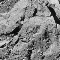
Posted by: Quetzalcoatl Apr 7 2020, 03:13 PM
Greetings to you all,
Looking back on two recent images of Bennu proposed by Marcin:
http://www.unmannedspaceflight.com/index.php?act=attach&type=post&id=45133
http://www.unmannedspaceflight.com/uploads/post-7860-1584699384_thumb.png
I'm not a geologist, but I know the cleavages and cleavage planes in mineralogy or crystallography, the sometimes surprising forms that nature offers us and all things proper to cause our perplexity.
For the case of these geometric forms on this scale, present on a rubble pile, does anyone have explanations, hypotheses or even ideas that would distance us from mere chance?
Are you aware of other similar examples in the large catalogue of spatial imaging of asteroids?
Posted by: john_s Apr 7 2020, 10:09 PM
Straight-line fractures ("joints") are pretty common on Earth- here's https://classconnection.s3.amazonaws.com/201/flashcards/2107201/jpg/joint1354150305467.jpg. They are a natural result of tectonic or other stresses in homogeneous rocks, and are different from the cleavage patterns you see in single crystals. The interesting question is what type of stresses (impact? thermal?) might do this on an asteroid surface.
John
Posted by: JRehling Apr 8 2020, 08:20 AM
Bennu originated as a fragment of a larger body, so both the breakup event and the possible forces within the parent body seem to be more likely sources of fractures than anything that would occur in a body the size of Bennu.
Posted by: Quetzalcoatl Apr 8 2020, 10:44 AM
John
Thank you very much John for your answer.
The Earth example you give us to see is spectacular and I know of others quite similar for our planet:
https://upload.wikimedia.org/wikipedia/commons/thumb/f/fe/0729_Orgelpfeifen_Damaraland.JPG/800px-0729_Orgelpfeifen_Damaraland.JPG
http://cirquedebarrosa.free.fr/Images/robdiaclase6.JPG
But the context and the training processes are well known, there is no mystery. I never thought of comparing the large rock fractures on Bennu with crystalline cleavages. I was simply referring to natural geometries.
It is the observation that you make at the end of your intervention, specific to asteroids, that intrigues me. The question can indeed be asked about the type of stress but perhaps also about the type of rock involved (or at least some of its characteristics).
Posted by: Quetzalcoatl Apr 8 2020, 10:48 AM
Good morning JRehling,
I had come to make this assumption, namely that these fractures and geometric forms did not come from in-situ processes but, more probably, were prior to the formation of Bennu, resulting from events having occurred on a parent body, The scars of an ancestor, I might say.
But my modest level of knowledge in this area is greatly enhanced by your expertise. Thank you.
Posted by: Marcin600 Apr 9 2020, 03:41 PM
Since „...the most prominent joints occur [on Earth] in the most well-consolidated, lithified, and highly competent rocks, such as sandstone, limestone, quartzite, and granite...” (https://en.wikipedia.org/wiki/Joint_(geology)), I think we can say - at least - that these two specific boulders (rock fragments) on Bennu are quite compact, and not „fluffy”, like http://www.hayabusa2.jaxa.jp/en/topics/20200318_nature/. But such rocks on Bennu are probably an exception, because so far only very few such geometric cracks have been photographed (?)
I'm not geologist, but I would bet on thermal stress for the reasons for these cracks.
Alternatively, it may have something to do with generating of stresses in rocks during collisions (impacts) - - maybe even on the parent body (although this second stone seems to have broken quite "recently" - on a cosmic time scale).
Posted by: Quetzalcoatl Apr 10 2020, 07:36 AM
Hello Marcin,
Some remarks to explain my point of view :
The object of my curiosity concerns the geometric shapes on the scale of the meter with two images that you had posted, namely a large straight fracture and what seems to me to be relatively flat surfaces with right angles.
Significant differences in daytime and nighttime T° can certainly cause rock fractures. But Id be surprised if that were the case here, for a straight fracture approximately three metres long.
Even more, on the second image that I had selected, what appears as flat surfaces seen from above (Strata?) with right angles do not seem to me to be able to be explained by thermal, mechanical processes (impact) or others affecting an asteroid with a gravity as low as Bennu.
My advice is given with caution, because I know very little.
Posted by: Marcin600 Apr 10 2020, 03:59 PM
Quetzalcoatl, are you suggesting some sort of bedding on Bennu or his perent body? That would be an interesting issue.
For me, these rectangular forms and flat plates on this little asteroid are quite mysterious, but - as I wrote - I am not a specialist...
On the other hand, on comets, such as Churyumov-Gerasimenko, we have a fractal structure: from microcrystals, through crystals to very large structures - everything reflects the original way of forming. Maybe in these two boulders on Bennu we actually see some "huge, original crystal structure", but it seems to me quite unlikely...
I think the biggest problem is that we really know very little about the nature of these rocks, their structure, origin, mechanical properties, mineralogical composition, etc. That is why we need samples of Bennu rocks in Earth's labs so much. Having them in our hands (with a little luck there will also be tiny fragments similar in properties to these interesting boulders) we will solve many puzzles.
From https://en.wikipedia.org/wiki/Joint_(geology)#/media/File:Joints_Caithness.JPG - Orthogonal joint sets on a bedding plane in flagstones, Caithness, Scotland, Earth and negative picture:
|
|
Posted by: Quetzalcoatl Apr 10 2020, 06:42 PM
For me, these rectangular forms and flat plates on this little asteroid are quite mysterious, but - as I wrote - I am not a specialist...
In any case, that is what I seem to see, in view of this image alone.
It would take others, taken in a more razing way to know exactly the shape of what is hidden under this flat surface. The thickness of what I think is a plate, a sheet, could be an element of a originally layered rock structure. If this were true, an exogenous origin in Ryugu would be, in my opinion, unquestionable. But these are speculations, I readily admit.
Mini-landers Minerva of the type Hayabusa 2 had dropped on Itokawa could have done wonders to examine closely the rocks of Ryugu. However, the possible rarity of the rock examples we are talking about here would certainly have made the desired observations very unlikely.
Posted by: Quetzalcoatl Apr 10 2020, 06:47 PM
I am often reserved enough to compare the geological characteristics of what we observe on asteroids with terrestrial examples. The physical conditions are too different. To a lesser degree, the similarities between cometary and asteroid surfaces must certainly be done with caution. I wont say any more.
Posted by: Quetzalcoatl Apr 10 2020, 06:52 PM
On that point, I completely join you. I am too impatient and it is very likely that the analysis of the samples will change our knowledge. They may also be able to shed light on our questions?...
Posted by: Marcin600 Apr 11 2020, 06:08 PM
Three days left until https://www.asteroidmission.org/?latest-news=rehearsal-time-for-nasas-asteroid-sampling-spacecraft
I wonder: can back-away burn at 75 m pick up any debris from Bennu's surface?
Posted by: Brian Swift Apr 11 2020, 08:54 PM
Any OSIRIS-REx navigation people here?
I'm wondering if SPICE kernels with predicts for Tuesday's “Checkpoint” rehearsal are publicly available anywhere.
The kernels I looked at from NAIF don't appear to include the maneuver.
Posted by: mcaplinger Apr 12 2020, 12:07 AM
I presume you looked at https://naif.jpl.nasa.gov/pub/naif/ORX/kernels/spk/orx_200305_200421_200410_od239-N-TR1P2-L_v1.bsp
I don't know what the TR1P2 maneuver is (TAG Rehearsal 1 Phasing 2?) but it's small and happened today, and that's the latest file out there. I'd check the mission status update on Monday to see if there are any new tidbits.
I don't know of a public site other than NAIF.
Posted by: Holder of the Two Leashes Apr 12 2020, 05:51 PM
A "trim" maneuver would be named TRnTn (fill in the n with some number). Two similarly named adjustments were cancelled according to this status report:
https://www.asteroidmission.org/status-updates/
I'm not sure what a "P" maneuver would be. Maybe phasing like you suggested. They did mention phasing burns in the status report.
Posted by: Brian Swift Apr 12 2020, 06:03 PM
Thanks Mike. Yup, that is what I'm looking at.
Posted by: mcaplinger Apr 12 2020, 07:16 PM
I think the first letters are the mission phase, for example there was a maneuver R3R (Recon 3R?). Not sure what the second letter means, there have been P, R, D, T. But I could be wrong.
I'm sure this is documented somewhere, but my access to OREx documents is limited and I couldn't tell you if I knew for sure anyway, so I'm just speculating.
Posted by: mcaplinger Apr 13 2020, 10:53 PM
See if https://naif.jpl.nasa.gov/pub/naif/ORX/kernels/spk/orx_200401_200421_200413_od240-N-TR1D-L-TR1BO_v1.bsp is what you're looking for.
Posted by: Marcin600 Apr 14 2020, 08:17 AM
Checkpoint rehearsal activities start today, April 14, at 2:45 pm EDT = 18:45 (6:45 pm) UTC - https://twitter.com/OSIRISREx
Operations plan - https://www.asteroidmission.org/wp-content/uploads/2020/04/Checkpoint-Rehearsal-Poster-9.pdf
https://www.asteroidmission.org/where-is-the-spacecraft/ is the current distance from Bennu - but I don't know how often it will be updated?
Posted by: Daniele_bianchino_Italy Apr 14 2020, 11:15 AM
For years I have imagined the small meteorites that fall to Earth like small-craterized, black, burnt, melted rocks. Only when I was older did I discover that burnt and melt is given by the heat of the impact with the atmosphere. So I imagine that the small meteorites that fall on Earth and give rise a Fireballs, if we observed them before the impact with our terrestrial atmosphere, are common rocks, very similar to the terrestrial ones, one of the many as seen above the Bennu terrain in this picture (Am I saying well?):
http://www.unmannedspaceflight.com/index.php?act=attach&type=post&id=45604
Posted by: mcaplinger Apr 14 2020, 04:45 PM
Here's a text file with the predicted position of OREx in the Bennu frame every minute for 24 hours starting at 2020-04-14T00:00:00 (time X Y Z) as extracted from orx_200401_200421_200413_od240-N-TR1D-L-TR1BO_v1.bsp tagr.txt ( 103.64K )
: 282
tagr.txt ( 103.64K )
: 282
Posted by: Brian Swift Apr 14 2020, 06:10 PM
Here's a visualization of the March 3, 2020 low (250m) pass over Nightingale. https://youtu.be/Px9JpK9PtZ0
Posted by: Marcin600 Apr 15 2020, 10:02 PM
Everything https://www.asteroidmission.org/?latest-news=one-step-closer-to-touching-asteroid-bennu And in large part thanks to the remote work of OSIRISRex team, in spite of the f... virus!
https://www.asteroidmission.org/checkpoint-rehearsal-movie/ on the OSIRISRex website: SamCam pictures (covering 10 minutes of descent) from 120 to 65 m (so, a bit lower than the planned 75 m), with extended sampling arm
|
|
|
Posted by: Holder of the Two Leashes Apr 16 2020, 01:13 PM
The approach test was a success. Here is Spaceflight Now's coverage of the event:
https://spaceflightnow.com/2020/04/15/osiris-rex-spacecraft-carries-out-first-of-two-rehearsals-before-sampling-asteroid/
Posted by: Brian Swift Apr 18 2020, 06:14 AM
If you'd like to walk around Bennu or set it on your desk, I've posted some AR Quick Look (Augmented Reality) globes at:
http://www.mandelbits.com/arworlds.html
These are viewable in Safari on devices running iOS 13 or later.
|
Posted by: JRehling Apr 18 2020, 07:59 PM
In at least one case, we have the answer, which is the Moon. Although a small fraction of found meteorites have a lunar origin, we know very well that rocks on the surface of the Moon are not burned or melted looking, and often look rather pristine, at least since the moment when they were last broken, shattered, and refused by impacts.
The diversity of meteorites is a large topic, and certainly Earth is very different from asteroid parent bodies. Stony achondrites, originating from larger parent bodies, including the Moon, sometimes can look a lot like an Earth rock, which is why stony achondrites are extremely hard to find except in locations where meteorites are easily distinguished from the local landscape, such as Antarctic ice. This is why virtually all lunar and martian meteorites have been found either in African deserts or Antarctica.
Chondrites, however, with small, unevolved parent bodies, are pretty easy to tell from Earth rocks, and it would seem like Bennu is composed of the same stuff as carbonaceous chondrites. If so, they may look like Earth rocks from OSIRIS-REx's cameras, but when sliced open will be completely different. It will be nice to get to verify this in 2023!
Posted by: Daniele_bianchino_Italy Apr 20 2020, 11:43 AM
The diversity of meteorites is a large topic, and certainly Earth is very different from asteroid parent bodies. Stony achondrites, originating from larger parent bodies, including the Moon, sometimes can look a lot like an Earth rock, which is why stony achondrites are extremely hard to find except in locations where meteorites are easily distinguished from the local landscape, such as Antarctic ice. This is why virtually all lunar and martian meteorites have been found either in African deserts or Antarctica.
Chondrites, however, with small, unevolved parent bodies, are pretty easy to tell from Earth rocks, and it would seem like Bennu is composed of the same stuff as carbonaceous chondrites. If so, they may look like Earth rocks from OSIRIS-REx's cameras, but when sliced open will be completely different. It will be nice to get to verify this in 2023!
Many thanks for the reply. Yes, I know that these rocks will be very different internally than the terrestrial ones. I was surprised to see common rocks, chipped, squared as in any terrain on Earth. In fanasia I expected a little more "alien" landscapes, instead I see landscapes very common and familiar to all of us, :-)
Posted by: Marcin600 Apr 20 2020, 06:53 PM
This is because the basic laws of physics are the same throughout the Universe. But if you stood on Bennu and kicked these stones you would immediately see the difference - if you found yourself in a cloud of rock fragments flying everywhere (due to microgravity, like https://www.youtube.com/watch?v=-3hO58HFa1M) - such things on Earth are impossible
Posted by: Marcin600 Apr 28 2020, 08:56 PM
Nice new pictures from the latest Checkpoint Rehearsal on the OSIRS-REx website, e.g. https://www.asteroidmission.org/20200414navcamcheckpoint/.
Here is my (very limited) play with a view towards Bennu's horizon.
No, this is not a real panorama (it's from 115 m above the surface) - not yet, unfortunately...
[only Harrison Schmitt is missing - that's a request to Neo ]
|

|
Posted by: Marcin600 Apr 28 2020, 11:05 PM
Just for fun - limited edition of Bennu (for Mars lovers) :

|
Posted by: Brian Swift May 12 2020, 12:45 AM
A simulated panorama and fisheye view from 50m below checkpoint rehearsal lowest point.
https://flic.kr/p/2j17cVShttps://flic.kr/p/2j17cVS by https://www.flickr.com/photos/bswift/, on Flickr
https://flic.kr/p/2j17cU4https://flic.kr/p/2j17cU4 by https://www.flickr.com/photos/bswift/, on Flickr
Posted by: Brian Swift May 17 2020, 07:41 AM
Checkpoint Rehearsal visualization on YouTube https://youtu.be/y3q9UtEDXOQ
Posted by: Explorer1 May 21 2020, 12:37 AM
Touchdown delayed to October 20th:
https://www.asteroidmission.org/?latest-news=nasas-osiris-rex-ready-for-touchdown-on-asteroid-bennu
Posted by: Marcin600 Jun 8 2020, 11:08 PM
https://www.asteroidmission.org/osprey-recon-c-mosaic-reduced-size/ of Osprey (backup site) on the OSIRIS-REx website - 347 PolyCam images collected on May 26 from 250 m, stitched together and corrected - 5 mm per pixel at full size!
Posted by: Marcin600 Jun 9 2020, 08:43 PM
Today, June 9, a very interesting article appeared in Nature Communications, regarding the issues we recently discussed in this forum thread:
https://www.nature.com/articles/s41467-020-16528-7.pdf
It has been summarized on the OSIRIS-REx website: https://www.asteroidmission.org/?latest-news=nasas-osiris-rex-discovers-sunlight-can-crack-rocks-on-asteroid-bennu
Few quotes:
“...This is the first time evidence for this process, called thermal fracturing, has been definitively observed on an object without an atmosphere...”
„ ...[OSIRIS-REx] found evidence of exfoliation, where thermal fracturing likely caused small, thin layers (1 – 10 centimeters) to flake off of boulder surfaces. The spacecraft also produced images of cracks running through boulders in a north-south direction, along the line of stress that would be produced by thermal fracturing on Bennu...”
„...Meteoroid impacts do occur on Bennu and can certainly crack rocks, but they would not cause the even erosion of layers from boulder surfaces that were seen. Also, there’s no sign of impact craters where the exfoliation is occurring...”
“...We don’t have good constraints yet on breakdown rates from thermal fracturing, but we can get them now that we can actually observe it for the first time in situ,” said OSIRIS-REx project scientist Jason Dworkin of NASA’s Goddard Space Flight Center in Greenbelt, Maryland. “Laboratory measurements on the properties of the samples returned by the spacecraft in 2023 will help us learn more about how this process works...”
|
Posted by: Holder of the Two Leashes Jun 17 2020, 01:49 PM
NASA has released a mosaic picture of the prime landing site Nightingale.
Here is a https://www.nasa.gov/feature/goddard/2020/osiris-rex-produces-nightingale-mosaic to the news release which in turn will provide a link to picture selection.
The full resolution mosaic is 345 PolyCam images stitched together, at a resolution of 4mm, is a 152 MB download and is 14371 X 14488 in size.
Posted by: Marcin600 Jun 19 2020, 05:08 PM
https://www.asteroidmission.org/20200526samplingrocks/, close to Osprey - taken by OSIRIS-REx PolyCam on May 26, from 0.3 km
|
Posted by: palebutdot Jul 14 2020, 07:09 AM
Earth and Moon seen from Asteroid Bennu
https://sbnarchive.psi.edu/pds4/orex/orex.t...ta_raw/orbit_a/

Posted by: Holder of the Two Leashes Aug 12 2020, 02:27 PM
According to the mission's Twitter site, the matchpoint rehearsal appears to have gone okay. They are still downloading data so there is yet to be any formal news release or status update.
https://twitter.com/OSIRISREx
Posted by: Explorer1 Aug 12 2020, 10:09 PM
Video is up!
https://www.youtube.com/watch?v=a1IdyXAwDXQ
Posted by: Phil Stooke Sep 11 2020, 11:03 PM
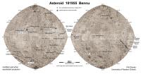
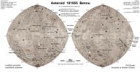
In preparation for the sampling I have updated my Bennu map. This uses a new paper in JGR-Planets to identify more particle ejection sites. With so many I have decided to remove the dates. Also added: dates of the imaging and rehearsal events for the candidate sites.
Phil

|
Posted by: Phil Stooke Sep 19 2020, 11:16 PM
Here is an interesting abstract from the Apophis workshop coming up in November:
http://www.hou.usra.edu/meetings/apophis2020/pdf/2008.pdf
It's an extended mission for OSIRIS-REx, which would orbit Apophis in 2029. This is just one of several suggestions for Apophis missions at:
https://www.hou.usra.edu/meetings/apophis2020/pdf/apophis2020_program.htm
Phil
Posted by: vjkane Sep 20 2020, 12:58 AM
As the abstract points out, OSIRIS-REx was designed to explore asteroids like this. I wonder if operations costs for the eight year flight time might be too much.
Posted by: Marcin600 Sep 23 2020, 05:48 AM
New, interesting results on the OSIRIS-Rex website: https://www.asteroidmission.org/?latest-news=nasas-osiris-rex-to-asteroid-bennu-youve-got-a-little-vesta-on-you
"...six boulders (1.5 to 4.3 m) scattered across Bennu’s southern hemisphere and near the equator...[are] almost ten times brighter than their surroundings...
[Spectrum] signature from the boulders [analyzed by OVIRS spectrometer] was characteristic of the mineral pyroxene, similar to what is seen on Vesta and the vestoids..."
Posted by: Phil Stooke Sep 23 2020, 06:48 AM
I just couldn't go to bed without adding those locations to the map. Very interesting!
Phil
|
Posted by: marsbug Sep 24 2020, 09:06 AM
That's an awesome map (I do have a soft spot for maps of strange and distant places)!
Posted by: Marcin600 Sep 24 2020, 06:07 PM
This is undoubtedly the best Bennu map!
I dream that one day Phil will make a complete atlas of small, non-spherical bodies of the Solar System (asteroids, comets, small moons) photographed so far by space probes
Posted by: Marcin600 Sep 26 2020, 03:18 AM
The first attempt of TAG sample collection event https://www.asteroidmission.org/?latest-news=osiris-rex-begins-its-countdown-to-tag
Posted by: Marcin600 Oct 12 2020, 01:44 AM
https://www.asteroidmission.org/?latest-news=nasas-osiris-rex-unlocks-more-secrets-from-asteroid-bennu
- carbon-bearing, organic material -> bright veins on boulders made of carbonate -> Bennus parent asteroid had an extensive hydrothermal system
- Bennus colors variations -> Nightingales regolith has only recently been exposed to the space weathering
- two main types of boulders: 1: dark, rough, weaker and more porous, and 2: bright, smooth, stronger and less porous (host the carbonates) -> formed at different depths in the parent asteroid -> both types are weaker than expected -> dark boulders would not survive the journey through Earths atmosphere -> this type of material is not currently represented in meteorite collections
- 3D digital terrain model of Bennu at 20 cm resolution (Laser Altimeter data) -> revealed ridge-like mounds that extend from pole-to-pole; northern and southern hemispheres have different shapes
- gravity field of Bennu determined by tracking the trajectories of the spacecraft and the particles naturally ejected from surface -> interior of Bennu is not uniform -> pockets of higher and lower density material inside; a void at Bennus center, within which you could fit a couple of football fields; the bulge at equator is under-dense -> Bennus rotation is lofting this material...
Posted by: Explorer1 Oct 12 2020, 04:21 AM
I don't understand how you could have a void at the centre of Bennu; where would all the fine material absent from the surface have migrated to? Don't get me wrong, a hollow asteroid would be an amazing discovery, but the paper itself ( https://advances.sciencemag.org/content/6/41/eabc3350 ) does not mention the 'void' quoted in the articles.
Posted by: mcaplinger Oct 12 2020, 06:42 AM
The article is IMHO an oversimplification (it says "as if" there was a void, not that there's really a void), but the paper does say that the core is underdense.
Posted by: Phil Stooke Oct 12 2020, 07:10 AM
"I dream that one day Phil will make a complete atlas of small, non-spherical bodies of the Solar System (asteroids, comets, small moons) photographed so far by space probes"
If people would stop doing things on the Moon and Mars I might have time for that.
Phil
Posted by: Marcin600 Oct 12 2020, 07:49 PM
Oversimplification can sometimes be the best way to attract people to "boring" science articles (describing reality)...
But in fact, doing so can be risky!
As for the loose structure of the interior and the migration of material, we should remember that on Bennu there is very, very little gravity and in these conditions the centrifugal force (as a result of rotation) becomes really important
Posted by: Marcin600 Oct 12 2020, 08:09 PM
If people would stop doing things on the Moon and Mars I might have time for that.
Phil
Well, then we will have to wait a long time - unfortunately

(the hope is that some great solar storm will damage all probes on Mars and the Moon at once
)
Posted by: HSchirmer Oct 12 2020, 09:37 PM
I believe that somewhere I found a paper on how the "brazil nut effect" (big pieces jostle to the top) can be reversed under certain conditions of temperature and gravity.
So, while we imagine Bennu as a spherical version of a 2 dimensional freeze-thaw "stone circle" it is at least possible that the inverse can happen, with fines preferentially sorting onto the surface.
Posted by: Holder of the Two Leashes Oct 15 2020, 02:21 PM
NASA will carry a live broadcast of the first sample collection attempt on Tuesday.
LINK: https://www.nasa.gov/press-release/nasa-to-broadcast-osiris-rex-asteroid-sample-collection-activities
Posted by: JRehling Oct 16 2020, 01:06 AM
The packing density of a conglomeration of random fragments can be in the ballpark of 0.36.
Then, a region near the center packed at that density would give you the same under-density as if there were a complete void somewhat smaller than that region.
Whether or not a world could evolve such that the central region is less packed than the "mantle" is an exercise left to the reader.
https://www.pnas.org/content/pnas/early/2014/06/04/1403768111.full.pdf
Posted by: Explorer1 Oct 20 2020, 05:41 PM
Livestream of simulated spacecraft events has started, link here:
https://www.asteroidmission.org/livestream/
NASA TV will go live at 5:00 EST.
Posted by: fredk Oct 20 2020, 06:39 PM
That's 5pm EDT, or 21:00 UT, for the live NASA TV coverage.
Posted by: Holder of the Two Leashes Oct 20 2020, 07:27 PM
The OSIRIS REx team is updating their Twitter account fairly often for the current hours leading up to collection. For those wanting to check in with those updates between now and NASA TV going live (and maybe after) you can go https://twitter.com/OSIRISREx.
Posted by: nprev Oct 20 2020, 09:30 PM
Coverage is live on https://www.nasa.gov/multimedia/nasatv/#public.
Posted by: mcaplinger Oct 20 2020, 09:43 PM
Livestream seems to have collapsed due to load. http://cristianopi.altervista.org/as/sonde_orx/a_temporea.html is a view from the SPICE predict files but without any spacecraft events [EDIT which seems to have errors of some sort, so ignore, livestream is back.]
Posted by: Explorer1 Oct 20 2020, 10:15 PM
TAG completed! Spacecraft going back up!
Posted by: mcaplinger Oct 20 2020, 10:16 PM
Sampling complete! Now to get the images back and verify sample mass.
Posted by: nprev Oct 20 2020, 10:19 PM
Outstanding!
One of the best parts of watching these live is seeing the joy of the team as years of hard work come to fruition. Congratulations to the people of OSIRIS-REx!!!!
Posted by: MahFL Oct 20 2020, 10:49 PM
Awesome. Now to see if they got enough sample.
Posted by: Marcin600 Oct 20 2020, 11:17 PM
Exciting !!!
From the https://www.nasa.gov/press-release/nasa-s-osiris-rex-spacecraft-successfully-touches-asteroid:
"The team can’t wait to receive the imagery from the TAG event late tonight and see how the surface of Bennu responded to the TAG event.”
“Our first indication of whether we were successful in collecting a sample will come on October 21 when we downlink the back-away movie from the spacecraft,” Moreau said. “If TAG made a significant disturbance of the surface, we likely collected a lot of material.”
"All spacecraft telemetry data indicates the TAG event executed as expected. However, it will take about a week for the OSIRIS-REx team to confirm how much sample the spacecraft collected."
Posted by: Brian Swift Oct 20 2020, 11:18 PM
Anyone have insight into why contact time (2020-10-20 21:50:10) from recent SPICE file
( orx_200827_201103_201019_od292-N-T1D-L-T1R1_v1.bsp )
was a 3 minutes off from actual time which was listed (with added light delay) in a press release on 10/14?
MEDIA ADVISORY M20-113 shows 6:12 p.m. EDT as collection time, -18.52min light travel time gives 21:53 UTC.
Posted by: mcaplinger Oct 21 2020, 03:35 PM
Data flowing to the DSN at 900 kbps. Press conference at 2 PM PDT today (10/21) on NASA TV.
Posted by: Explorer1 Oct 21 2020, 09:11 PM
IMAGES UP:
https://www.nasa.gov/feature/goddard/2020/osiris-rex-tags-surface-of-asteroid-bennu/
Posted by: Marcin600 Oct 21 2020, 10:14 PM
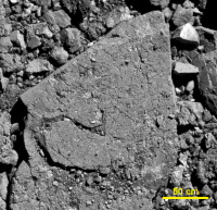
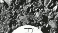
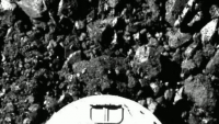
"Upon initial contact, the TAGSAM head appears to crush some of the porous rocks underneath it." (from https://www.nasa.gov/feature/goddard/2020/osiris-rex-tags-surface-of-asteroid-bennu/)
Dark porous rock crushed by the TAGSAM head (I think so):
|
|
Posted by: fredk Oct 22 2020, 02:59 AM
Aligned on the ground:
|
Posted by: abalone Oct 22 2020, 04:34 AM
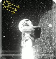
Good spray of material with the nitrogen blast. This is what they were looking for to indicate a good potential for a sample
https://youtu.be/LJBv4reH9IU
Posted by: Brian Swift Oct 22 2020, 07:59 AM
Here is a re-timed version of TAG images, running about 2-3x realtime. https://youtu.be/6X10esr6Snw
Posted by: Explorer1 Oct 22 2020, 11:59 AM
The dark shadow of the debris cloud is especially impressive towards the end.
Would any images of the site taken later on to see surface changes? The official website says they are not returning to the vicinity if there is enough sample collected.
From: https://www.asteroidmission.org/asteroid-operations/
It seems that any scientific benefit to observing the excavated subsurface is outweighed by spacecraft safety?
Posted by: john_s Oct 22 2020, 02:56 PM
I'm having a little trouble understanding the dark background, starting the instant the gas is released and debris starts flying. Is the debris cloud so dense that it instantaneously blocks almost all sunlight from reaching the ground below? I guess that's the case, but it seems surprising. And then why is there such a well-defined edge to the shadow in the final frames? Why does the debris cloud have sharp enough edge to cast a shadow like that?
John
Posted by: Brian Swift Oct 22 2020, 04:31 PM
I assumed the sharp edge shadow at the end was from the rim of the crater that was just created. Would be nice if more images from high up get released before proprietary times up.
I wonder if Bennu is so loosely packed, the a spacecraft could bore a hole all the way through, if it had a sufficient gas supply.
Posted by: neo56 Oct 22 2020, 04:52 PM
I'm asking the same question John. Some people suggest a crater could have formed due to nitrogen gas expulsion. Wait and see!
By the way, I played myself with the sequence of TAG images. Here I aligned on the ground several pictures taken when OSIRIS-REx moved away from Bennu:
https://www.flickr.com/photos/thomasappere/50516292028/sizes/o/
Posted by: Marcin600 Oct 22 2020, 06:18 PM
Since the shadows in the pictures are to the right of the stones (and not on the left), it seems to me that this big sharp shadow is caused by an object protruding above the surface - such as a nearby large boulder (located to the left and "up" from the field of view).
If it were a depression (the alleged crater), we would see its slope illuminated rather than shaded (shade opposite to that of stones).
So I think it's a big boulder and not a "crater".
All this is combined with a "fuzzy shadow" of a great mass of debris carried away by nitrogen and - above all - by the ship's engines
(picture "borrowed" from neo56)
|
Posted by: Bagelvoid Oct 22 2020, 06:33 PM
https://youtu.be/LJBv4reH9IU
Thank you for making the retimed video. Really like it touchdown on the rocky equivalent of styrofoam or cheese puff.
The rocks are "just" hold" together. Nitrogen pressure might have been overkill.
Hope they got a good sample.
Posted by: JRehling Oct 22 2020, 06:45 PM
Wow, the expectation was that these rocks would be unlike anything in our meteorite collections because they couldn't survive entering the Earth's atmosphere. That turns out to be a profound understatement. These samples really could represent something we've never seen before.
Posted by: walfy Oct 22 2020, 08:28 PM
John
I was wondering exactly the same thing. Very perplexing. Neo56's excellent sequence (https://www.flickr.com/photos/thomasappere/50516292028/sizes/o/) makes me think it's a crater and not a shadow, but then again, the edge of the "crater" seems to shift, like it's a dust shadow.
Or perhaps the edge of the crater is settling and shifting slowly. Considering that the astroid is active, popping up little parts of itself that slowly settle back on the surface, played out over billions of years the surface might be somewhat like a children's ball bit with light plastic balls to easily sink into.
Posted by: HSchirmer Oct 22 2020, 11:28 PM
It reacts like a frozen clump of sand or gravel.
Not unlike the lumps you get in a salt shaker near the ocean -
Random video- https://www.facebook.com/watch/?v=10155535292172786
Posted by: Holder of the Two Leashes Oct 23 2020, 03:22 PM
Maybe a possible reason why we never found any large samples - only possible dust microsamples - from the Tunguska event?
Posted by: john_s Oct 23 2020, 04:33 PM
Or perhaps the edge of the crater is settling and shifting slowly. Considering that the astroid is active, popping up little parts of itself that slowly settle back on the surface, played out over billions of years the surface might be somewhat like a children's ball bit with light plastic balls to easily sink into.
Thanks- Neo56's sequence makes things clearer. It does look like the gas release rapidly excavated a surprisingly large crater, which is responsible for most of the shadowing. In that sequence the crater shape appears to be relatively stable (because the shadow edge is relatively stable) but the stuff inside it is still churning around in the microgravity. I hope there are frames later in the sequence that we haven't seen yet, which show the view from a greater distance.
Hopefully the surface put up enough resistance to provide the back-pressure necessary to propel material upward into the sample chamber.
John
Posted by: Decepticon Oct 23 2020, 09:20 PM
Is there a minimum weight requirement in the sample to be considered a successful sample return?
Posted by: mcaplinger Oct 23 2020, 09:28 PM
Yes, 60 grams. https://www.asteroidmission.org/?latest-news=nasas-osiris-rex-spacecraft-collects-significant-amount-of-asteroid-bennu
Posted by: Guillermo Abramson Oct 23 2020, 09:58 PM
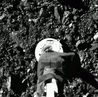
So much sample was collected that some of it is actually slowly escaping the sampling head. Sample mass measuremente has been cancelled to protect the sample, and they will store it as it is.
https://twitter.com/OSIRISREx/status/1319750746741612546

|
Posted by: Marcin600 Oct 23 2020, 10:54 PM
"...Analysis by the OSIRIS-REx team suggests that bits of material are passing through small gaps where the head’s mylar flap is slightly wedged open. The mylar flap (the black bulge on the left inside the ring) is designed to keep the collected material locked inside, and these unsealed areas appear to be caused by larger rocks that didn’t fully pass through the flap..."
"All data so far suggest that the collector head is holding much more than 2 ounces of regolith" (https://www.nasa.gov/press-release/nasa-s-osiris-rex-spacecraft-collects-significant-amount-of-asteroid)
I wonder if these escaping pieces of rocks will not cause a problem with the tight closure of the sampler head in the return capsule 
Posted by: Explorer1 Oct 23 2020, 11:09 PM
Wow, it is literally chock-full of sample! A nice problem to have....I almost expected that given the enormous cloud, but good to know for sure!
Posted by: Brian Swift Oct 23 2020, 11:14 PM
From the audio teleconference:
- Estimating 400g collection
- Proceeded 24-48cm into regolith with gas being expelled
- Continued to move forward for an additional 3 seconds after gas release while backoff thrusters were firing before moving away
- 90-95% of TAGSAM screen blocked with material
- Didnt test deep penetration on ground
- Didnt plan on material coming out of TAGSAM during stow
- Trying to get DSN time for continuous coverage during stow for "ground in the loop" operations
- Moving away from Bennu at 40cm/s. Cancled breaking burn to minimize imparting forces on samples
- Cant do sample mass measurement after stow
- Minimizing exposure to sun to prevent overheating sample. So wont be able to have camera on it while "parked" before stow
- Can have up to 5mm particle on TAGSAM face for stow, currently largest is 4mm
- Only one of several latches required for earth re-entry
Posted by: Marcin600 Oct 23 2020, 11:36 PM
"...Continued to move forward for an additional 3 seconds after gas release while backoff thrusters were firing before moving away..."
Could the gases from the backoff thrusters "contaminate" the samples?
Posted by: Tom Tamlyn Oct 23 2020, 11:55 PM
Is the audio teleconference available online?
Posted by: mcaplinger Oct 23 2020, 11:56 PM
One thing that surprised me was Dante talking about "dust loading" (I think he said) on Navcam and SamCam. I wonder how dirty the nadir panel of the spacecraft is now?
Posted by: Brian Swift Oct 24 2020, 01:07 AM
I don't see it archived online. I listened to it through https://t.co/mzKW5uV4hS?amp=1 which came from a NASA tweet.
Posted by: Explorer1 Oct 24 2020, 03:47 AM
Could the gases from the backoff thrusters "contaminate" the samples?
Their composition is well know, it should not be an issue.
Also, given that there has been a sadly permanent departure from Bennu, perhaps it is time for a new thread? It's the opposite of an approach now....
Posted by: nprev Oct 24 2020, 07:04 AM
Good idea. For everything happening post-boop please discuss it in this http://www.unmannedspaceflight.com/index.php?showtopic=8573.
Posted by: Greenish Nov 1 2020, 05:30 AM
Aligned sequence helping to show where the TAG happened.
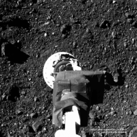
|
Full-res/all frames: https://imgur.com/a/OMXXS55
Single frame/multi-exposure version:
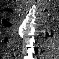
|
Powered by Invision Power Board (http://www.invisionboard.com)
© Invision Power Services (http://www.invisionpower.com)