Opportunity Route Map |

  |
Opportunity Route Map |
 May 24 2005, 08:34 AM May 24 2005, 08:34 AM
Post
#451
|
|
|
Member  Group: Members Posts: 877 Joined: 7-March 05 From: Switzerland Member No.: 186 |
Hi alan, certainly that's the shortest route map about the rovers ever seen - congratulation!

-------------------- |
 |
 
|
|
Jun 5 2005, 08:20 AM
Post
#452
|
||
 The Insider Group: Members Posts: 669 Joined: 3-May 04 Member No.: 73 |
Well, now that Oppy is free, time for maps again...
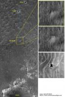
Big congrats to JPL/NASA for the job well done! You guys are just awesome, what can I say... Anyway, I've been trying to localize the exact spot of Oppy's quagmire, based on orbital images and using the overhead projection posted by JPL a few weeks ago. Check it out...
Attached thumbnail(s)
|
|
|
|
|
|
| Guest_Sunspot_* |
Jun 5 2005, 08:37 AM
Post
#453
|
|
Guests |
Wow.........by sheer bad luck it looks like they hit the biggest dune/drift there is in the area

|
|
|
|
| Guest_Sunspot_* |
Jun 5 2005, 09:56 AM
Post
#454
|
|
Guests |
http://www.msnbc.msn.com/id/8098155/
"The Erebus Highway" Where will Opportunity go? Eventually, Opportunity will resume its southward trek, heading first for a bright feature nicknamed the Erebus Highway, about 130 yards (120 meters) away, Squyres said. The "highway" could be a stretch of exposed bedrock, leading toward Erebus Crater which would be a very good thing for Squyres and his colleagues. Or it could be a huge pile of Martian dust. |
|
|
|
|
Jun 5 2005, 12:24 PM
Post
#455
|
|
 Member Group: Members Posts: 524 Joined: 24-November 04 From: Heraklion, GR. Member No.: 112 |
Great job Pando !
"Erebus Highway" must be the bright linear feature at the bottom of your image. It looks like the dunes go right through it, I am not so sure there will be a lot of outcrop exposed there. Should be more stable to navigate, hopefully 
|
|
|
|
|
Jun 5 2005, 12:57 PM
Post
#456
|
|
|
Senior Member Group: Members Posts: 2998 Joined: 30-October 04 Member No.: 105 |
RE: Pando's Quagmire map
Interesting. She got stuck at the transition between the NE-SW trending dunes we've been travelling in and the "mottled" area around Erebus. The small crater to the SW of the sandtrap does not have the characteristic Evaporite Halo around it, so I presume that this terrain is deep and dusty... --Bill -------------------- |
|
|
|
|
Jun 5 2005, 05:53 PM
Post
#457
|
|
 Senior Member Group: Members Posts: 1887 Joined: 20-November 04 From: Iowa Member No.: 110 |
Those "fish scales" must be larger dunes with the drifts lying on top of them. Oppy had the bad luck of running head on into the last one in her path. A short drive to the west should get her around it.
|
|
|
|
|
Jun 5 2005, 05:57 PM
Post
#458
|
|
 Member Group: Members Posts: 753 Joined: 23-October 04 From: Greensboro, NC USA Member No.: 103 |
Looks like we'll have to be very careful in and around Erebus, too. There are some very pronounced dunes throughout the northeast part of the crater.
-------------------- Jonathan Ward
Manning the LCC at http://www.apollolaunchcontrol.com |
|
|
|
|
Jun 5 2005, 10:40 PM
Post
#459
|
|
 Member Group: Members Posts: 813 Joined: 8-February 04 From: Arabia Terra Member No.: 12 |
QUOTE (ilbasso @ Jun 5 2005, 05:57 PM) Looks like we'll have to be very careful in and around Erebus, too. There are some very pronounced dunes throughout the northeast part of the crater.  With any luck they'll be so large that Oppy can drive comfortably between them. |
|
|
|
|
Jun 6 2005, 01:27 AM
Post
#460
|
|
 Junior Member Group: Members Posts: 24 Joined: 6-March 05 Member No.: 185 |
QUOTE (alan @ Jun 5 2005, 05:53 PM) Those "fish scales" must be larger dunes with the drifts lying on top of them. Oppy had the bad luck of running head on into the last one in her path. A short drive to the west should get her around it. Oppy looks close to the edge of a large flat looking area just to the south. Oppy can drive accross that in a south x south east direction to reach the "rock highway to Erebus." (sounds like a good name for a song) |
|
|
|
|
Jun 6 2005, 08:47 AM
Post
#461
|
|
 Member Group: Members Posts: 593 Joined: 20-April 05 Member No.: 279 |
QUOTE (Bill Harris @ Jun 5 2005, 12:57 PM) Interesting. She got stuck at the transition between the NE-SW trending dunes we've been travelling in and the "mottled" area around Erebus. The small crater to the SW of the sandtrap does not have the characteristic Evaporite Halo around it, so I presume that this terrain is deep and dusty... Hi Bill! I'm not so sure...If the white flecks on the photo depict the sort of dunes Oppy was in, and got stuck in, they disappear within a few tens of metres to the south of her current position. That makes me think that these dunes are virtually spent. The crater you mention as potentially in deep dust, is perhaps half the size of Viking & Voyager, and possibly the reason for a lack of an EH is this small size. Compare, for example, this little crater to the one on the border of the photo to the east of Voyager - same sort of size, no evaporite. Is it a scale thing? Were I behind the wheel, I'd send Opportunity sse/s to skirt the edges of the rippled dune-sea, driving on the less topographically obvious (flatter?) dark terrain, and then have a rethink once I reached the lighter material marking the start of the Erebus highway. Andy, optimism returning for Victoria... |
|
|
|
|
Jun 6 2005, 09:06 AM
Post
#462
|
|
 Senior Member Group: Members Posts: 3419 Joined: 9-February 04 From: Minneapolis, MN, USA Member No.: 15 |
QUOTE (Buck Galaxy @ Jun 5 2005, 08:27 PM) Oppy looks close to the edge of a large flat looking area just to the south. Oppy can drive accross that in a south x south east direction to reach the "rock highway to Erebus." (sounds like a good name for a song) Sounds like a song cue for a Hope-Crosby road picture -- "Ohhh, we're off on the highway to Erebus. You never know when we'll get stuck! Yes, as we salley fore, we'll see some dunes and more -- the odds are even we'll run into Dorothy Lamour!" -the other Doug -------------------- The trouble ain't that there is too many fools, but that the lightning ain't distributed right. -Mark Twain
|
|
|
|
|
Jun 6 2005, 05:21 PM
Post
#463
|
||
|
Member Group: Members Posts: 753 Joined: 23-October 04 From: Greensboro, NC USA Member No.: 103 |
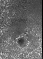
Is it just me, or does the "Erebus Highway" appear to be the eastern edge of a very large and shallow circular depression, with the NW edge of Erebus forming the SE edge of the depression? It looks like an ancient crater that has been almost completely filled in.
Attached thumbnail(s)
-------------------- Jonathan Ward
Manning the LCC at http://www.apollolaunchcontrol.com |
|
|
|
|
|
|
Jun 6 2005, 06:18 PM
Post
#464
|
|
|
Solar System Cartographer Group: Members Posts: 10169 Joined: 5-April 05 From: Canada Member No.: 227 |
Ilbasso, it's not just you. I thought the same.
Phil -------------------- ... because the Solar System ain't gonna map itself.
Also to be found posting similar content on https://mastodon.social/@PhilStooke Maps for download (free PD: https://upload.wikimedia.org/wikipedia/comm...Cartography.pdf NOTE: everything created by me which I post on UMSF is considered to be in the public domain (NOT CC, public domain) |
|
|
|
|
Jun 6 2005, 06:32 PM
Post
#465
|
|
 Member Group: Members Posts: 510 Joined: 17-March 05 From: Southeast Michigan Member No.: 209 |
I believe that's the part of the rim of the old crater they refer to as "Terra Nova".
See Squyres update, April 18. But I think that Erebus Highway is actually the NW rim, however, as I always thought Erebus was imbedded in the western half of Terra Nova, with the eastern-most rim of Erebus being the center of Terra Nova. Now where did I put my PaintShop PRO.... -------------------- --O'Dave
|
|
|
|
|

|
Lo-Fi Version | Time is now: 27th May 2024 - 04:52 PM |
|
RULES AND GUIDELINES Please read the Forum Rules and Guidelines before posting. IMAGE COPYRIGHT |
OPINIONS AND MODERATION Opinions expressed on UnmannedSpaceflight.com are those of the individual posters and do not necessarily reflect the opinions of UnmannedSpaceflight.com or The Planetary Society. The all-volunteer UnmannedSpaceflight.com moderation team is wholly independent of The Planetary Society. The Planetary Society has no influence over decisions made by the UnmannedSpaceflight.com moderators. |
SUPPORT THE FORUM Unmannedspaceflight.com is funded by the Planetary Society. Please consider supporting our work and many other projects by donating to the Society or becoming a member. |
|