Endeavour Drive - Drivability analysis |

  |
Endeavour Drive - Drivability analysis |
 Sep 23 2008, 01:55 AM Sep 23 2008, 01:55 AM
Post
#166
|
|
 Senior Member  Group: Members Posts: 1229 Joined: 24-December 05 From: The blue one in between the yellow and red ones. Member No.: 618 |
Fran O's point is IMHO an important one. It reminds us that it is very difficult to improve upon the information content of a high resolution HiRISE image of the ground we want to cross. Why would we prefer a color-coded indication of the average size or interval or direction of ripples over a broad area, when we can see each and every ripple ahead of us on the photograph? We can literally measure the distance between two particular ripples and know whether the rover will fit between them. We can see whether one particular trough leads to an interesting cobble and choose to follow it for that reason. We can see that there is an open roadway of exposed bedrock trending in the direction we want to go, and so move directly toward it to facilitate our progress, while getting a good look at the nature of the bedrock along the way.
I would like to reiterate the goal of our PIs to examine ejecta cobbles which may be samples of subsurface Meridiani rock not yet studied. The 'randomly scattered' small cobbles exposed throughout the region are not especially likely to represent the former. They may have traveled any distance, from a few kilometers to thousands of kilometers, and so represent any Martian area. It is the large clusters of cobbles that are more likely to have come from fresh craters in the immediate area, e.g. Beagle Crater, that are likely to include samples from the Meridiani subsurface. These should be a primary goal of our track. We really should go over the best HiRISE mosaic of the southeast quandrant from Victoria to highlight these clusters and try to work them into our proposed track. -------------------- My Grandpa goes to Mars every day and all I get are these lousy T-shirts!
|
 |
 
|
|
Sep 23 2008, 01:56 AM
Post
#167
|
|
|
Junior Member Group: Members Posts: 20 Joined: 9-August 08 From: Lucens, CH Member No.: 4309 |
I find imipak's idea great.
QUOTE One of the gurus drops a reasonably fine-scale grid over a the best HiRISE shots of the entire area. Make each grid square, say, 100m x 100m My 2 cents: Each square would have a model of the rover to scale embedded (so you could drive around the ripples.  . If you scale the image the rover would scale too. . If you scale the image the rover would scale too. In addition each square would have an arrow with the general direction of driving (to determine this, is the tricky part; maybe another guru could). The volunteer would then select 3-5 routes with the least crest crossings (which I understand is the major concern of the whole drive). Some other guru would then assemble the individual squares and determine the consensus route(s). |
|
|
|
|
Sep 23 2008, 03:49 AM
Post
#168
|
|
 Member Group: Members Posts: 236 Joined: 5-June 08 From: Udon Thani Member No.: 4185 |
Both the direction and the 'wavelength' of the ripples (compared to the length of the rover) are of great importance. Having to run straight against the direction of the ripples, even for a very short while, can cost you a lot of delay. From this point of view 'avoiding the dots' might not necessarily be the best option, if it results in a route where, somewhere along the way, you have to run against some bad ripples. If you create a route where you run in between the ripples you might still be able to make reasonable speed, even in a field of ripples.
Normally in my job I guide big containerships across the oceans, which has a bit in common with this situation in that we know our point of departure and our destiny and we have a fixed departure date and a scheduled arrival time. In between is a big ocean which we divide in squares with each square having its own predicted weather (with a given percentage of certainty), waves of a certain direction and a certain length, wind from a certain direction, etc, etc. Once you have all these squares filled in with their predicted wave-condition it is quite easy to let the computer calculate the most optimal route. For this we use a polar diagram stating the speed and fuel consumption of the vessel when meeting waves of a certain height and certain wavelength from a certain direction. Given the experience with oppy it might be possible to make a similar diagram: how much progress can it make when meeting ripples of a certain wavelength at a certain angle? Once you have this diagram it is reasonable easy to have a computer figure out the best route through a complex ripple-field. Note for ships we normally find that the height of the waves is of less importance then their wavelength (compared to the ships length), I guess it is more or less similar for oppy: a low but steep ripple will give you far more trouble then a high but 'long' ripple. Is there a way we can use the sun-angle in the various HiRISE images to predict wavelength and direction of the ripples? Ripples will reflect more or less light depending on the sunangle and their own wavelength and direction. Even the filter used on the particular image might help to identify direction and wavelength of the ripples. Looking at only the colour of the terrain in one particular image seems too vague for me, you can only compare it to known terrain if the sun angle in both images is the same. I guess the biggest issue is not 'plotting a route' but 'filling in the squares', finding a method to predict direction and wavelength of the ripples etc, from the HiRISE images, only once we have figured this out and we have a 'polar diagram' for oppy given the expected progress in a certain direction in any type of terrain, we can start plotting a route. With a bit of software-engineering you might even be able to leave the final route-planning completely up to oppy itself, just upload a detailed digital map of the terrain (stating direction and wavelength of ripples and sort of terrain in any position) and enter a position where you like to go to and a date and time of scheduled arrival and it should be able to plot its own optimal route through any terrain, no matter how complex, we do this for ships on a daily basis so it's not really that complicated, the BIG trick is finding a way to get an accurate digital map of the terrain. |
|
|
|
|
Sep 23 2008, 04:23 AM
Post
#169
|
|
 Senior Member Group: Members Posts: 2228 Joined: 1-December 04 From: Marble Falls, Texas, USA Member No.: 116 |
QUOTE (imipak @ Sep 22 2008, 03:18 PM)  Good/bad idea? It sounds like a very good and doable idea to me.QUOTE (SFJCody @ Sep 22 2008, 03:30 PM) ...load the data into Surfer as a grid and contour it to make a colour coded overlay. I think you would have to import the data as a csv or a spreadsheet, then create a grid from it using the algorithm of your choice. Then you could contour the grid. I own a copy of Surfer, so if the project gets this far, I'd be happy to grid and contour the data.QUOTE (Phil Stooke @ Sep 22 2008, 05:01 PM) OK, OK, I said I couldn't do it, but I couldn't resist an experiment. That's pretty impressive for a quick experiment, Phil. I'm glad you couldn't resist. Here's hoping you continue to not resist. ... Phil [attachment=15704:south_of...map_post.jpg] 
-------------------- ...Tom
I'm not a Space Fan, I'm a Space Exploration Enthusiast. |
|
|
|
|
Sep 23 2008, 04:50 AM
Post
#170
|
|
 Senior Member Group: Admin Posts: 4763 Joined: 15-March 05 From: Glendale, AZ Member No.: 197 |
QUOTE (Phil Stooke @ Sep 22 2008, 04:01 PM) OK, OK, I said I couldn't do it, but I couldn't resist an experiment. I mosaicked several screen shots off the IAS viewer at 25% scale - which is fine for identifying large drifts. I high pass filtered it to take out gradients. I grossly increased contrast, so every shaded drift surface was black, most of the rest white. [attachment=15704:south_of...map_post.jpg] Now if someone were to repeat Phil's experiment at three different levels of contrast, and then drop each of the three into a different color layer you would get a nice colored spectrum of possible dune size/density. -------------------- If Occam had heard my theory, things would be very different now.
|
|
|
|
|
Sep 23 2008, 05:46 AM
Post
#171
|
|
 The Poet Dude Group: Moderator Posts: 5551 Joined: 15-March 04 From: Kendal, Cumbria, UK Member No.: 60 |
QUOTE (Shaka @ Sep 23 2008, 01:06 AM) In fact, if I could choose just one person to be cast away on a desert island with Stu, I'd choose you. I can't decide if that's very funny, or very hurtful...  -------------------- |
|
|
|
|
Sep 23 2008, 06:38 AM
Post
#172
|
|
 Member Group: Members Posts: 813 Joined: 8-February 04 From: Arabia Terra Member No.: 12 |
QUOTE (CosmicRocker @ Sep 23 2008, 05:23 AM) I think you would have to import the data as a csv or a spreadsheet, then create a grid from it using the algorithm of your choice. Then you could contour the grid. I own a copy of Surfer, so if the project gets this far, I'd be happy to grid and contour the data. Of course, should have said 'convert to a grid.' Another copy of Surfer here. If it becomes necessary it might be good to make a record of which software tools people on the forum have access to so we know who to pass data to for particular kinds of processing.
|
|
|
|
|
Sep 23 2008, 06:58 AM
Post
#173
|
||
|
Member Group: Members Posts: 202 Joined: 9-September 08 Member No.: 4334 |
If I may butt into a discussion by far more knowledgeable people -
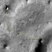
Looking at that map made by Phil and the path by TheChemist, there looks to be a section where even the best path will go through a nasty section. I took the liberty of marking that part of the route red. Will something special have to be done here? Is there a realistic possibility that good HiRISE imagery will show a good path not visible with this picture, or will Oppy simply have to forge on through? (The places I put yellow spots look a little nasty, too, but not nearly as bad). I'm not criticizing the route - just asking how this will be handled. By the way, what portion of the distance to Endeavour does this map cover? Are we aiming for a certain point on the rim, so that we should angle left or right leaving the bottom of this map? How does the risk of crossing dune fields compare to the risk of taking a longer but safer route, giving the wheels more time to fail? Or is dune travel slow enough that it's always more risky?
Attached thumbnail(s)
|
|
|
|
|
|
|
Sep 23 2008, 07:10 AM
Post
#174
|
|
 Special Cookie Group: Members Posts: 2168 Joined: 6-April 05 From: Sintra | Portugal Member No.: 228 |
QUOTE (Shaka @ Sep 23 2008, 01:06 AM) In fact, if I could choose just one person to be cast away on a desert island with Stu, I'd choose you.  Me - Hey! Stu!... looks like I caught a fish for dinner... Stu - This surely deserves a sonet! Let me work on it! ... Stu - Rui! Isn't that a boat?! They've come to rescue us! Me - Rescue...boat...us...(processing information...)... My friend...Who are we, Mankind, but the rescue, the boat, the sea, the Onward?... And then we would battle ourserlves to death with coconuts...  --- Fran, a pleasure to have you around! Your blog's last entry about Opportunity is, for sure, one of the most elucidative I've read since the beggining of the mission! I'll keep an eye on your work waiting for the one you've promised about Spirit... Incredible to see all those brains working...I really like Geert's approach, don't know if it is feasible, but surely would bring Oppy to a point that, with no additional mechanical problem, would take her even further, and faster, away... David, I love those maps too... If, in the future, you think about coming to Portugal I would suggest you to visit the Jerónimos and to take some time and thoughts in front of Vasco da Gama's tomb...closing your eyes, I am sure you'll be able to listen to the waves... -------------------- "Ride, boldly ride," The shade replied, "If you seek for Eldorado!"
Edgar Alan Poe |
|
|
|
|
Sep 23 2008, 07:15 AM
Post
#175
|
||
|
Newbie Group: Members Posts: 14 Joined: 23-October 06 Member No.: 1277 |
A little route from me..
There is this small, but prehaps pretty deep cater half way that I think we should see.. The crater next to it is much more shallow.. ("non deep"). I asume this is a matter of age ? than drive on to the big one.. and there is that crater in the rim (is it so smooth, because water flowed in ??) that.. if we reach it.. could be very useful to examine.. it has about the same size as Vicotria, but because of the location -in the rim- seems very different .. if 'something' indeed flowed into the crater(s) there.. there will be many great things to discover there (too).. OOoh it has already been such a great journey.. and it will continue ! From now on.. I sit back and enjoy every ride ... It is like an early Sinterklaas .. an early december Thanks !
Attached thumbnail(s)
|
|
|
|
|
|
|
Sep 23 2008, 07:38 AM
Post
#176
|
|
|
Member Group: Admin Posts: 976 Joined: 29-September 06 From: Pasadena, CA - USA Member No.: 1200 |
QUOTE (Shaka @ Sep 22 2008, 05:55 PM) Fran O's point is IMHO an important one. It reminds us that it is very difficult to improve upon the information content of a high resolution HiRISE image of the ground we want to cross. Why would we prefer a color-coded indication of the average size or interval or direction of ripples over a broad area, when we can see each and every ripple ahead of us on the photograph? We can literally measure the distance between two particular ripples and know whether the rover will fit between them. We can see whether one particular trough leads to an interesting cobble and choose to follow it for that reason. We can see that there is an open roadway of exposed bedrock trending in the direction we want to go, and so move directly toward it to facilitate our progress, while getting a good look at the nature of the bedrock along the way. You are correct in saying that the original HiRISE image has the maximum content of information, but I do not think that laying down the path precisely to the single ripple crossing makes much sense. Very likely along our way science might find some interesting targets. Maybe Pancams will show that crossing the ripple at a different location is more advantageous. HiRISE, for the great tool it is (it is an amazing tool!) does not reliably provide information on the details the drivers need for each individual drive. Since we have seen that there are areas where we can drive more easily and areas where it is more difficult, this map will give us a general idea of where the potentially dangerous terrain is and maybe where the faster terrain to traverse is. When we planned the drive down from Endurance we really did not have all the details laid out. This was partly due to the fact that at that time we only had MOC imagery, but mostly because it is extremely expensive to define the minute details and very likely those details will need to be changed to accommodate contingencies. We will definitely use the full-res images for mid- and near-term planning, but at this time we need to have a general idea of how to get to our destination. QUOTE I would like to reiterate the goal of our PIs to examine ejecta cobbles which may be samples of subsurface Meridiani rock not yet studied. The 'randomly scattered' small cobbles exposed throughout the region are not especially likely to represent the former. They may have traveled any distance, from a few kilometers to thousands of kilometers, and so represent any Martian area. It is the large clusters of cobbles that are more likely to have come from fresh craters in the immediate area, e.g. Beagle Crater, that are likely to include samples from the Meridiani subsurface. These should be a primary goal of our track. We really should go over the best HiRISE mosaic of the southeast quandrant from Victoria to highlight these clusters and try to work them into our proposed track. I'm fully aware that we are there for science, not driving. I respect that and am glad we are there for this reason but from what Steve Squyres told me, the cobbles are randomly scattered, nor I heard from him to differentiate between isolated cobbles and clusters. I'm not disputing your statement (I don't have any competence in this matter) and will leave the science to the science people. If they will indicate that they want to go to specific locations along the path we will take notice, see if the science targets are reachable and advise them if they are not. So far I have not received any indication of specific targets. This does not mean we will not get indications, simply I have not received any so far. So for the time being my problem still is "find the quickest and safest path to Endeavour". Paolo -------------------- Disclaimer: all opinions, ideas and information included here are my own,and should not be intended to represent opinion or policy of my employer.
|
|
|
|
|
Sep 23 2008, 08:34 AM
Post
#177
|
|
|
Senior Member Group: Moderator Posts: 4279 Joined: 19-April 05 From: .br at .es Member No.: 253 |
QUOTE (Geert @ Sep 23 2008, 05:49 AM) I guess the biggest issue is not 'plotting a route' but 'filling in the squares', finding a method to predict direction and wavelength of the ripples etc, from the HiRISE images, only once we have figured this out and we have a 'polar diagram' for oppy given the expected progress in a certain direction in any type of terrain, we can start plotting a route. Completely agree. And perhaps we could even "simplify" this process by assuming a fixed direction (NNW - SSE) for the ripples because we are talking of a small area (tens of Kms) when comparing to oceanic proportions. |
|
|
|
|
Sep 23 2008, 09:45 AM
Post
#178
|
|
 Member Group: Members Posts: 524 Joined: 24-November 04 From: Heraklion, GR. Member No.: 112 |
Please, don't waste any time looking at the "path" I posted earlier here.
 I specifically said this was a late night game of avoiding the dots (or big concentrations of them), the line was drawn in 10 sec ! My apologies, I thought the tone and copious use of smilies made the (lack of) seriousness of the post clear. Please go on working on making sure Oppy is safe during her trip to Ithaca, kicking some Laestrygon b..tt on the way. |
|
|
|
|
Sep 23 2008, 11:31 AM
Post
#179
|
|
|
Member Group: Members Posts: 206 Joined: 15-August 07 From: Shrewsbury, Shropshire Member No.: 3233 |
The BBC website has a news article about the trek to Endeavour:
http://news.bbc.co.uk/1/hi/sci/tech/7630617.stm This seemed to be largely based upon the JPL press release. However it did contain a statement that I had not read before: "The rover will stop to study rocks on the way, and in winter months it cannot move because there is not enough sunlight to provide sufficient power for driving." I had thought that because Oppy is frequently cleaned by the wind and because Oppy is much nearer to the equator than Spirit that Oppy would have no problem in driving during the Winter. |
|
|
|
|
Sep 23 2008, 12:09 PM
Post
#180
|
|
|
Founder Group: Chairman Posts: 14432 Joined: 8-February 04 Member No.: 1 |
Yup - the BBC are overstating there. Being equatorial, and clean, Oppy doesn't suffer anything like the trouble Spirit does.
Doug |
|
|
|
|

|
Lo-Fi Version | Time is now: 27th April 2024 - 07:34 PM |
|
RULES AND GUIDELINES Please read the Forum Rules and Guidelines before posting. IMAGE COPYRIGHT |
OPINIONS AND MODERATION Opinions expressed on UnmannedSpaceflight.com are those of the individual posters and do not necessarily reflect the opinions of UnmannedSpaceflight.com or The Planetary Society. The all-volunteer UnmannedSpaceflight.com moderation team is wholly independent of The Planetary Society. The Planetary Society has no influence over decisions made by the UnmannedSpaceflight.com moderators. |
SUPPORT THE FORUM Unmannedspaceflight.com is funded by the Planetary Society. Please consider supporting our work and many other projects by donating to the Society or becoming a member. |
|